Embed Size (px)
Citation preview
Active Low-Angle Reverse Fault and Wide
Quaternary Deformation Identified in Jhura Trench across the Kachchh Mainland Fault,
Kachchh, Gujarat, India
Michio Morinoa, Javed N. Malikb, Gadhavi Mahendrasinh S c,
Khalid Ansarib, Chandrashekhar Bhuiyan b,
Prashant Mishra b, and Fumio Kaneko a
Abstract
The Kachchh region has suffered from at least four damaging moderate to large earthquakes since the 17th
century. However, none of these earthquakes except the 1819 Allah Bund earthquake accompanied surface
rupture. Even the recent 2001 Bhuj earthquake with Mw7.6 occurred on a blind fault. Several faults in the
Kachchh viz. the Island Belt Fault, the Kachchh Mainland Fault (KMF), and the Katrol Hill Fault were suggested
to be active during Late Quaternary time by previous studies. But there is no such supportive evidence available
in the historical documents; also none of recent studies except ours (Morino et al., 2007, Malik et al., 2008, and
Morino et al., 2008) reported ground truth that these fault are active.
<BR>We in our earlier paper reported faulting in Late Pleistocene to Holocene age sediment near the Lodai
Village along the KMF. To confirm further active faulting along the KMF, paleoseismic investigation near
Jhura Village about 30 km west of Lodai revealed an active fault displacing overbank deposits of Kaila River.
Two fault strands Fl and F2 were identified in the trench. The northern Fl shows a low-angle reverse fault with
inclination of 15° towards the south. At least two faulting events were inferred on the basis of upward fault
termination with clear angular unconformity. The net-slip during a single faulting event considering deformation
on the hanging wall of Fl fault is over 5 m.
1. Introduction
The Kachchh region, which lies in the western part of the
Indian shield, has suffered severe damages from moderate
to large intra-plate earthquakes since the 17th century, viz.,
the 1668 Indus Delta earthquake (M7), the 1819 Allah Bund
earthquake (M7.8), the 1956 Anjar earthquake (Mw6.0), and the
recent 2001 Bhuj earthquake (Mw7.6) (Johnston and Kanter,
1990; Chung and Gao, 1995). The 1819 event along the Allah
Bund Fault (ABF) is a well documented earthquake in literature
(right top inset of Fig. 1), resulting in formation of 4-6 m
high fault scarp with rupture extending along the E-W strike
up to 80-90 km (Quittmeyer and Jacob, 1979; Johnston and
Kanter, 1990; Bilham, 1998). However, other earthquakes were
generated along blind faults. Though the magnitude of the 2001
event was Mw7.6, the rupture remained concealed below the
ground at a depth of 7-10 km (Mandal and Horton, 2007). So,
if blind faults in the Kachchh region are capable of generating
earthquakes with magnitude as large as Mw7.6, it is possible that
active faults with larger rupture area also have the potential to
generate a similar or larger magnitude earthquake.
The Island Belt Fault (IBF), the Kachchh Mainland Fault
(KMF), and the Katrol Hill Fault (KHF) except the ABF are
well-known as major E-W trending faults in the Kachchh region
(Fig.1). The IBF, the KMF, and the KHF mark geological
OYO International Corporation, Rokubancho Kyodo Bldg. 2F, 6 Rokubancho, Chiyoda-ku, Tokyo, Japan
Department of Civil Engineering, Indian Institute of Technology Kanpur, Kanpur 208-016, India
Institute of Seismological Research, Gandhinagar 382018, Gujarat, India
boundary between Lower Jurassic-Upper Triassic and Middle
Jurassic, Middle Jurassic and Tertiary deposits, and Upper-
Middle Jurassic and Lower Cretaceous, respectively (Biswas
and Deshpande, 1970; Biswas, 1980). Based on the occurrence
of uplifted Late Quaternary fluvial and alluvial fan surfaces
along the northern fringe of the Northern Hill Range (NHR) and
along the Katrol Hill Range (KHR), the KMF and the KHF were
suggested to be active (Sohoni et al., 1999; Malik et al., 2001b).
However, no active fault exposure was reported till now. Based
on the satellite photo interpretation, Malik et al. (2001a) inferred
several active fault traces along the KMF and the KHF. But
the field survey and trench investigation were not carried out.
Morino et al. (2007), Malik et al. (2008) and Morino et al. (2008)
were the first to undertake paleoseismic investigations and report
evidence of active faults displacing Quaternary deposits in the
Kachchh region.
We reexamined the satellite photo interpretation made by
Malik et al. (2001a), and conducted field survey along the KMF.
From trench investigation carried out during March-April 2007
near Lodai Village across the KMF, we were able to establish
the KMF as an active fault displacing Late Quaternary alluvial
fan deposits and Banni Plain sediments (Morino et al., 2007;
Malik et al., 2008). To know the further extent of the paleo-
surface rupture that was identified in the Lodai trench, we
carried out trench investigation on the left bank of Kaila River
near Jhura Village about 30 km west of Lodai site, during May
2007 and December 2007 to January 2008 (Figs. 1 and 2a).
A low-angle reverse fault displacing channelized overbank
deposits of Kaila River was identified. In this paper, we report
the nature of active fault, event horizons, and a net-slip during a
single faulting event, though the dating for Optically Stimulated
Luminescence (OSL) is still in process. The data generated from
this study will be very significant for seismic disaster assessment
in the Kachchh region.
2. Geomorphology around the Jhura trench
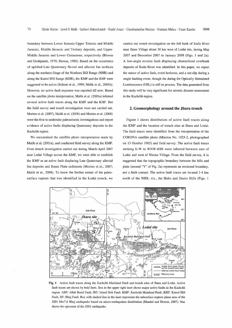
Figure 1 shows distribution of active fault traces along
the KMF and the location of trench sites at Jhura and Lodai.
The fault traces were identified from the interpretation of the
CORONA satellite photo (Mission No. 1025-2, photographed
on 13 October 1965) and field survey. The active fault traces
striking E-W to WNW-ESE were inferred between east of
Lodai and west of Nirona Village. From the field survey, it is
suggested that the topographic boundary between the hills and
plain (around "Y" of Fig. 2a) represents an erosional boundary,
not a fault contact. The active fault traces are located 1-4 km
north of the NHR, viz., the Habo and Jhurio Hills (Figs. 1
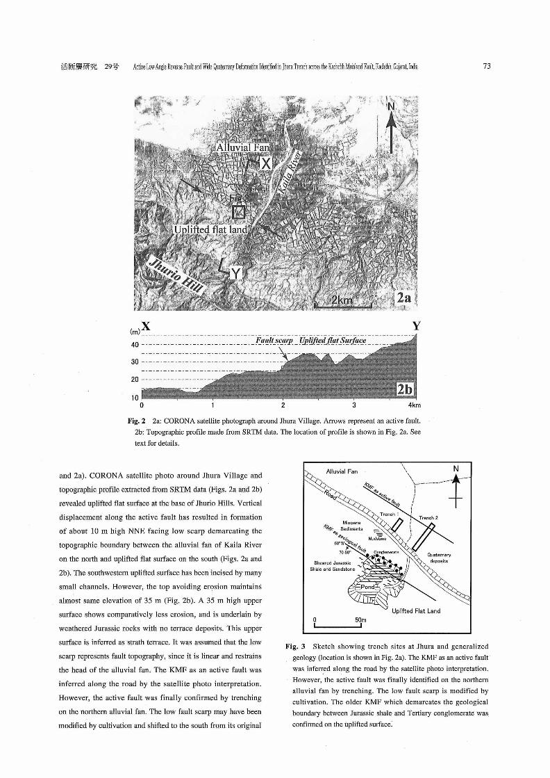
and 2a). CORONA satellite photo around Jhura Village and
topographic profile extracted from SRTM data (Figs. 2a and 2b)
revealed uplifted flat surface at the base of Jhurio Hills. Vertical
displacement along the active fault has resulted in formation
of about 10 m high NNE facing low scarp demarcating the
topographic boundary between the alluvial fan of Kaila River
on the north and uplifted flat surface on the south (Figs. 2a and
2b). The southwestern uplifted surface has been incised by many
small channels. However, the top avoiding erosion maintains
almost same elevation of 35 m (Fig. 2b). A 35 m high upper
surface shows comparatively less erosion, and is underlain by
weathered Jurassic rocks with no terrace deposits. This upper
surface is inferred as strath terrace. It was assumed that the low
scarp represents fault topography, since it is linear and restrains
the head of the alluvial fan. The KMF as an active fault was
inferred along the road by the satellite photo interpretation.
However, the active fault was finally confirmed by trenching
on the northern alluvial fan. The low fault scarp may have been
modified by cultivation and shifted to the south from its original
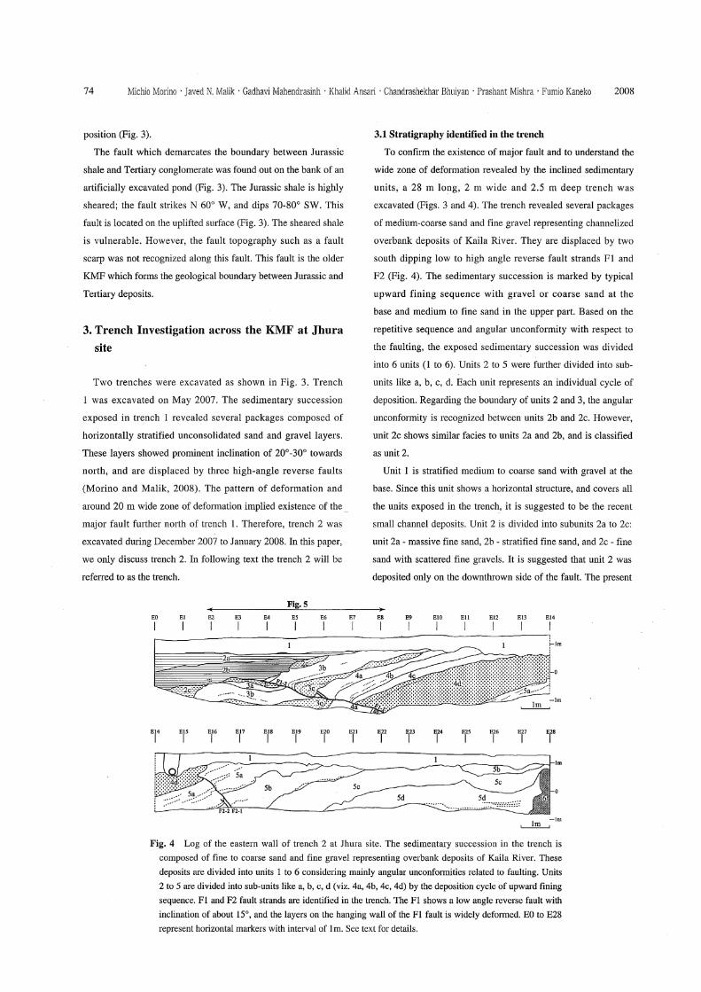
position (Fig. 3).
The fault which demarcates the boundary between Jurassic
shale and Tertiary conglomerate was found out on the bank of an
artificially excavated pond (Fig. 3). The Jurassic shale is highly
sheared; the fault strikes N 600 W, and dips 70-80° SW. This
fault is located on the uplifted surface (Fig. 3). The sheared shale
is vulnerable. However, the fault topography such as a fault
scalp was not recognized along this fault. This fault is the older
KMF which forms the geological boundary between Jurassic and
Tertiary deposits.
3. Trench Investigation across the KMF at Jhura
site
Two trenches were excavated as shown in Fig. 3. Trench
1 was excavated on May 2007. The sedimentary succession
exposed in trench 1 revealed several packages composed of
horizontally stratified unconsolidated sand and gravel layers.
These layers showed prominent inclination of 20°-30° towards
north, and are displaced by three high-angle reverse faults
(Morino and Malik, 2008). The pattern of deformation and
around 20 m wide zone of deformation implied existence of the
major fault further north of trench 1. Therefore, trench 2 was
excavated during December 2007 to January 2008. In this paper,
we only discuss trench 2. In following text the trench 2 will be
referred to as the trench.
3.1 Stratigraphy identified in the trench
To confirm the existence of major fault and to understand the
wide zone of deformation revealed by the inclined sedimentary
units, a 28 m long, 2 m wide and 2.5 m deep trench was
excavated (Figs. 3 and 4). The trench revealed several packages
of medium-coarse sand and fine gravel representing channelized
overbank deposits of Kaila River. They are displaced by two
south dipping low to high angle reverse fault strands Fl and
F2 (Fig. 4). The sedimentary succession is marked by typical
upward fining sequence with gravel or coarse sand at the
base and medium to fine sand in the upper part. Based on the
repetitive sequence and angular unconformity with respect to
the faulting, the exposed sedimentary succession was divided
into 6 units (1 to 6). Units 2 to 5 were further divided into sub-
units like a, b, c, d. Each unit represents an individual cycle of
deposition. Regarding the boundary of units 2 and 3, the angular
unconformity is recognized between units 2b and 2c. However,
unit 2c shows similar facies to units 2a and 2b, and is classified
as unit 2.
Unit 1 is stratified medium to coarse sand with gravel at the
base. Since this unit shows a horizontal structure, and covers all
the units exposed in the trench, it is suggested to be the recent
small channel deposits. Unit 2 is divided into subunits 2a to 2c:
unit 2a - massive fine sand, 2b - stratified fine sand, and 2c - fine
sand with scattered fine gravels. It is suggested that unit 2 was
deposited only on the downthrown side of the fault. The present
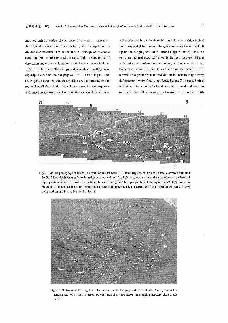
inclined unit 2b with a dip of about 3° due north represents
the original surface. Unit 3 shows fining upward cycle and is
divided into subunits 3a to 3c: 3a and 3b - fine gravel to coarse
sand, and 3c - coarse to medium sand. This is suggestive of
deposition under overbank environment. These units are inclined
10°-15° to the north. The dragging deformation resulting from
dip-slip is clear on the hanging wall of Fl fault (Figs. 4 and
5). A gentle syncline and an anticline are recognized on the
footwall of Fl fault. Unit 4 also shows upward fining sequence
with medium to coarse sand representing overbank deposition,
and subdivided into units 4a to 4d. Units 4a to 4d exhibit typical
fault-propagated-folding and dragging movement near the fault
tip on the hanging wall of Fl strand (Figs. 4 and 6). Units 4a
to 4d are inclined about 25° towards the north between E6 and
El0 horizontal markers on the hanging wall, whereas, it shows
higher inclination of about 60° due north on the footwall of Fl
strand. This probably occurred due to intense folding during
deformation, which finally got faulted along Fl strand. Unit 5
is divided into subunits 5a to 5d: unit 5a - gravel and medium
to coarse sand, 5b - massive well-sorted medium sand with
scattered cobbles, 5c - poorly sorted fine to medium sand, and
5d - stratified medium sand. Unit 6 is weakly consolidated sandy
silt with coarser angular fragments representing older debris
deposits probably derived from the hanging wall.
3.2 Paleoseismic interpretations
Two prominent fault strands Fl and F2 dipping towards the
south were identified in the trench (Fig. 4). Fl strand is a low-
angle reverse fault with inclination of about 15°. Two seismic
events are properly understood by dividing Fl fault into two
fault strands F1-1 and F1-2. F1-1 strand extends from E8 to
20 cm north of E6 horizontal marker. F1-2 strand extends
from E6 to E4 (Fig. 5). Upper two faults observed around E6
are not subsidiaries of Fl fault. These faults are inferred to be
the extension of F1-1 strand. F1-1 strand displaces units 4a to
4d, and is covered with unit 3c. Furthermore, the F1-1 strand
reactivated after the deposition of units 2c to 3c, and the F1-2
strand propagated northward from E6. F1-2 strand displaces
units 2c to 3c, and is covered with unit 2b. The layers on the
hanging wall of Fl fault are deformed widely between E4 and
E23. The width of the deformation is about 20 m. Another set of
high-angle reverse faults (F2-1 and F2-2) with inclination of 50
° towards the south were identified around E16 to E17 . Judging
from the 20 m. wide deformation associated with Fl fault, it is
suggested that the F2 fault may be a secondary fault.
Two clear angular unconformities (shown by thick lines in
Fig. 5) were observed along F1-1 and F1-2 fault strands. One
unconformity is marked by prominent variation in inclinations
between units 4a to 4d with dip of about 25° and that of units 2c
to 3c about 10°-15°. Also the thickness of unit 3c between E6
and E9 is about 20 cm, whereas, between E5 and E6 it is about
60 cm. This suggests that unit 3c was deposited after a faulting
event occurred along F1-1 strand displacing unit 4. The unit 4
became inclined by the activity of F1-1 fault. Similarly, units
2a and 2b covering units 2c to 3c mark another major angular
unconformity.
Based on the stratigraphic cross-cutting relationship, variation
in inclination of the units and angular unconformities, at least
two seismic events are inferred. The F1-2 fault displaces unit 2c
and is covered unconformably with unit 2b. The latest seismic
event occurred after the deposition of unit 2c and before the
deposition of unit 2b. Also the F1-1 fault displaces unit 4 and is
covered unconformably with unit 3c. Therefore, it is suggested
that the penultimate seismic event occurred after the deposition
of unit 4a and before the deposition of unit 3c.
F2-1 strand displaces the lower part of unit 4d. However, the
fault dies out upward in the unit 4d, without showing upward
fault termination against an unconformity. The event occurred
after the deposition of unit 4d is only inferred. The F2-1 strand
may have activated accompanied by the latest or penultimate
event along Fl fault. However, unit 4d seems to cover unit 5a
unconformably, though the depth of the trench is not enough. If
the unconformity was formed by the activity of Fl fault, then the
third-to-the-last event may have occurred after the deposition of
unit 5a and before the deposition of unit 4d.
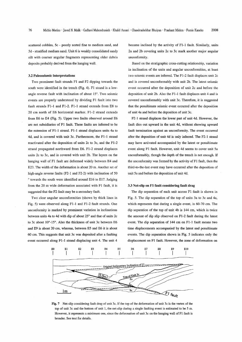
3.3 Net-slip on Fl fault considering fault drag
The dip separation of each unit across Fl fault is shown in
Fig. 5. The dip separation of the top of units 3a to 3c and 4a,
which represents that during a single event, is 60-70 cm. The
dip separation of the top of unit 4b is 144 cm, which is twice
the amount of dip slip observed on F1-2 fault during the latest
event. The dip separation of 144 cm on F1-1 fault means two
time displacements accompanied by the latest and penultimate
events. The dip separation shown in Fig. 5 indicates only the
displacement on Fl fault. However, the zone of deformation on
the hanging wall of Fl fault is very wide. This clearly indicates
that most of the displacement accompanied by the activity
of Fl fault is accommodated by folding at shallow depths on
the hanging wall. Therefore, we considered the wide zone of
deformation to estimate the true net-slip.
Since units 2c, 3a, and 3b are eroded, we discuss the
deformation of unit 3c for calculating net-slip during a single
event. The estimated net-slip is shown in Fig. 7. Because unit 3c
is deformed both on the hanging wall and on the footwall, the
true net-slip should be calculated by restoring the deformation
to original sedimentary inclination. On the hanging wall of Fl
fault, the net-slip is estimated as the vertex of the observed fault
and the line inclined 3° towards the north drawn from the top
of the deformation. On the footwall of Fl fault, unit 3c shows
a gentle syncline and an anticline. Therefore, we assumed that
the middle line between the top and bottom of the deformation
is regarded as original sedimentary surface of unit 3c. The top
of the deformation of unit 3c on the hanging wall is unknown,
since the unit 3c is eroded accompanied by the deposition of
unit 1. If the top of the deformation of unit 3c is the vertex of the
top of unit 3c and the bottom of unit 1, the net-slip is about 5 m.
However, it represents a minimum one, since the deformation of
unit 3c on the hanging wall is broader.
4. Conclusion
From the present study we are able to draw the following
conclusions:
1) Our study shows that the KMF has been active during
Late Quaternary time and has the potential to produce large
magnitude earthquakes in the future. There are no historical
records suggesting occurrence of earthquakes along the KMF
during historic past.
2) Trench data revealed occurrence of at least two major
faulting events on the KMF. The faults in young alluvium
terminate dip-slip against clear angular unconformities in the
Jhura trench. The time of events is expected to be decided with
narrow range.
3) The KMF is a low-angle reverse fault with inclination of 15°
towards the south.
4) The amount of net-slip at depth during a single event is
estimated to be more than 5 m, which is much larger than the
slip measured in trench. This is because most of the deformation
is accommodated by drag folding in young alluvium at shallow
depths.
Acknowledgements
The authors are thankful to Rajesh Kishore, Chief Executive
Officer, GSDMA, for his permission to publish this work.
The authors are grateful to Dr. B. K. Rastogi, Institute of
Seismological Research, Prof. S. K. Jain, India Institute of
Technology Kanpur, and Dr. Alpa Sheth, VMS Consultants
Private Limited, for the discussion on this study.
References
Bilham, R., 1998, Slip parameters for the Rann of Kachchh, India,
16 June 1819 earthquake quantified from contemporary accounts.
in Coastal Tectonics Stewart, I. S. and Vita-Finzi, C. (editors),
Geological Society of London, 146, 295-318.
Biswas, S. K., 1980, Structure of Kutch-Kathiawar Region, Western
India. Proc. 3rd Ind. Geol. Congr. Pune, 255-272.
Biswas, S. K. and Deshpande, S. V., 1970, Geological and tectonic
maps of Kutch. Bulletin of Oil Nat. Gas Comm., 7, 115-123.
Chung W-Y. and Gao H., 1995, Source parameters of the Anjar
earthquake of July 21, 1956, India, and its seismotectonic
implications for the Kutch rift basin. Tectonophysics, 242,
281-292.
Johnston, A. C. and Kanter, L. R., 1990, Earthquakes in stable
continental crust. Scientific American, 262, 69-75.
Malik, J. N., Nakata, T., Sato, H., Imaizumi, T. Yoshioka, T., Philip,
G., Mahajan, A. K., and Karanth, R. V., 2001a, January 26, 2001,
the Republic Day (Bhuj) earthquake of Kachchh and active faults,
Gujarat, western India. Active Fault Research, 20, 112-126.
Malik J. N., Sohoni, P. S., Merh, S. S., and Karanth, R. V., 2001b,
Active tectonic control on alluvial fan architecture along the
Kachchh Mainland Hill Range, Western India. Zeithschrift fiir
Geomorphologie, 45, 1, 81-100.
Malik, J. N., Morino, M., Mishra, P., Bhuiyan, C., and Kaneko,
F., 2008, First active fault exposure identified along Kachchh
Mainland Fault: evidence from trench excavation near Lodai
village, Gujarat, Western India. Journal of the Geological Society
of India, 71, 201-208.
Mandal, P. and Horton, S., 2007, Relocation of aftershocks, focal
mechanisms and stress inversion: Implications toward the
seismo-tectonics of the causative fault zone of Mw7.6 2001 Bhuj
earthquake (India). Tectonophysics, 429, 61-78.
Morino, M., Malik, J. N., Mishra, P., Bhuiyan, C., and Kaneko, F.,
2007, Trench survey across Kachchh Mainland Fault at Lodai
village, Kachchh, Gujarat, India. Journal of the Geological
Society of Japan, 113, pictorial, 15-16.
Morino, M. and Malik, J. N., 2008, Field trip guide to international
workshop on active fault in Kachchh (18-19 January 2008 at Bhuj, Kachchh). Zip.
Morino, M., Malik, J. N., Mishra, P., Bhuiyan, C., and Kaneko, F.,
2008, Active fault traces along Bhuj Fault and Katrol Hill Fault,
and trenching survey at Wandhay, Kachchh, Gujarat, India.
Journal of Earth System Science, 117, 181-188.
Quittmeyer, R. C. and Jacob, K. H., 1979, Historical and modern seismicity of Pakistan, Afghanistan, North-western India and
South-eastern Iran. Bulletin of the Seismological Society of
America, 69, 773-823.
Sohoni, P. S., Malik, J. N., Merh, S. S., and Karanth, R. V., 1999,
Active tectonics astride Katrol Hill Zone, Kachchh, Western
India. Journal of the Geological Society of India, 53, 579-586.
Received : June 9, 2008
Accepted : September 18, 2008
Key words : active fault, trench investigation, Kachchh Mainland Fault, Gujarat