Embed Size (px)
Citation preview
An overview of regional experiments on biomass burning aerosolsand related pollutants in Southeast Asia: From BASE-ASIA and theDongsha Experiment to 7-SEASq
Neng-Huei Lin a,*, Si-Chee Tsay b, Hal B. Maring c, Ming-Cheng Yen a, Guey-Rong Sheu a,Sheng-Hsiang Wang a,d, Kai Hsien Chi e, Ming-Tung Chuang f, Chang-Feng Ou-Yang g,Joshua S. Fu h,i, Jeffrey S. Reid j, Chung-Te Lee f, Lin-Chi Wang k,l, Jia-Lin Wang g,Christina N. Hsu b, Andrew M. Sayer b,m, Brent N. Holben b, Yu-Chi Chu n,Xuan Anh Nguyen o, Khajornsak Sopajaree p, Shui-Jen Chen q, Man-Ting Cheng r,Ben-Jei Tsuang r, Chuen-Jinn Tsai s, Chi-Ming Peng t, Russell C. Schnell u, Tom Conway u,Chang-Tang Chang v, Kuen-Song Linw, Ying I. Tsai x,y, Wen-Jhy Lee z, Shuenn-Chin Chang n,Jyh-Jian Liu n, Wei-Li Chiang n, Shih-Jen Huang aa, Tang-Huang Lin bb, Gin-Rong Liu bb
aDepartment of Atmospheric Sciences, National Central University, Chung-Li, TaiwanbNASA Goddard Space Flight Center, Greenbelt, MD, USAcNASA Headquarters, Washington, DC, USAdNASA Postdoctoral Program Fellow, Goddard Space Flight Center, NASA, Greenbelt, MD, USAe Institute of Environmental and Occupational Health Sciences, National Yang Ming University, Taipei, TaiwanfGraduate Institute of Environmental Engineering, National Central University, Chung-Li, TaiwangDepartment of Chemistry, National Central University, Chung-Li, TaiwanhDepartment of Civil and Environmental Engineering, The University of Tennessee, Knoxville, TN, USAiUTK-ORNL Center for Interdisciplinary Research and Graduate Education, Knoxville, TN, USAjNaval Research Laboratory, Monterey, CA, USAkDepartment of Chemical and Materials Engineering, Cheng Shiu University, Kaohsiung, Taiwanl Super Micro Mass Research and Technology Center, Cheng Shiu University, Kaohsiung, TaiwanmGoddard Earth Sciences Technology And Research (GESTAR), Universities Space Research Association (USRA), Columbia, MD, USAnTaiwan Environmental Protection Administration, Taipei, Taiwano Institute of Geophysics, Vietnam Academy of Science and Technology, Hanoi, Viet NampDepartment of Environmental Engineering, Chiang Mai University, Chiang Mai, ThailandqDepartment of Environmental Engineering and Science, National Pingtung University of Science and Technology, Nei-Pu, Pingtung, TaiwanrDepartment of Environmental Engineering, National Chung Hsing University, Taichung, Taiwans Institute of Environmental Engineering, Nation Chiao Tung University, Hsinchu, TaiwantWeatherRisk Explore Inc., Taipei, TaiwanuNOAA ESRL Global Monitoring Division, Boulder, CO, USAvDepartment of Environmental Engineering, National Ilan University, Yilan, TaiwanwDepartment of Chemical Engineering and Materials Science, Yuan Ze University, Chung-Li, TaiwanxDepartment of Environmental Resources Management, Chia Nan University of Pharmacy and Science, Tainan, TaiwanyDepartment of Environmental Engineering and Science, Chia Nan University of Pharmacy and Science, Tainan, TaiwanzDepartment of Environmental Engineering, National Cheng Kung University, Tainan, TaiwanaaDepartment of Marine Environmental Informatics, National Taiwan Ocean University, Keelung, TaiwanbbCenter for Space and Remote Sensing Research, National Central University, Chung-Li, Taiwan
q This is an open-access article distributed under the terms of the Creative Commons Attribution License, which permits unrestricted use, distribution, and reproduction inany medium, provided the original author and source are credited.* Corresponding author.
E-mail address: [email protected] (N.-H. Lin).
Contents lists available at SciVerse ScienceDirect
Atmospheric Environment
journal homepage: www.elsevier .com/locate/atmosenv
1352-2310/$ e see front matter � 2013 The Authors. Published by Elsevier Ltd. All rights reserved.http://dx.doi.org/10.1016/j.atmosenv.2013.04.066
Atmospheric Environment 78 (2013) 1e19
https://ntrs.nasa.gov/search.jsp?R=20140010868 2020-04-23T10:37:28+00:00Z
h i g h l i g h t s g r a p h i c a l a b s t r a c t
� First comprehensive field study ofbiomass burning conducted in thenorthern SEA.
� First in-situ measurements of airchemistry and physics in South ChinaSea/East Sea.
� A conceptual model of circulationflows constructed for transport ofbiomass burning.
� Characterization of biomass-burningaerosols in source/sink region innorthern SEA.
� Spatial distribution of Hg and POPsover northern SEA is illustrated.
a r t i c l e i n f o
Article history:Received 8 February 2013Received in revised form18 April 2013Accepted 22 April 2013
Keywords:Biomass burningAerosolAir toxicsSoutheast Asia7-SEASBASE-ASIADongsha Experiment
a b s t r a c t
By modulating the Earth-atmosphere energy, hydrological and biogeochemical cycles, and affectingregional-to-global weather and climate, biomass burning is recognized as one of the major factorsaffecting the global carbon cycle. However, few comprehensive and wide-ranging experiments have beenconducted to characterize biomass-burning pollutants in Southeast Asia (SEA) or assess their regionalimpact on meteorology, the hydrological cycle, the radiative budget, or climate change. Recently, BASE-ASIA (Biomass-burning Aerosols in South-East Asia: Smoke Impact Assessment) and the 7-SEAS (7-South-East Asian Studies)/Dongsha Experiment were conducted during the spring seasons of 2006and 2010 in northern SEA, respectively, to characterize the chemical, physical, and radiative properties ofbiomass-burning emissions near the source regions, and assess their effects. This paper provides anoverview of results from these two campaigns and related studies collected in this special issue, entitled“Observation, modeling and impact studies of biomass burning and pollution in the SE Asian Environ-ment”. This volume includes 28 papers, which provide a synopsis of the experiments, regional weather/climate, chemical characterization of biomass-burning aerosols and related pollutants in source and sinkregions, the spatial distribution of air toxics (atmospheric mercury and dioxins) in source and remoteareas, a characterization of aerosol physical, optical, and radiative properties, as well as modeling andimpact studies. These studies, taken together, provide the first relatively complete dataset of aerosolchemistry and physical observations conducted in the source/sink region in the northern SEA, withparticular emphasis on the marine boundary layer and lower free troposphere (LFT). The data, analysisand modeling included in these papers advance our present knowledge of source characterization ofbiomass-burning pollutants near the source regions as well as the physical and chemical processes alongtransport pathways. In addition, we raise key questions to be addressed by a coming deployment duringspringtime 2013 in northern SEA, named 7-SEAS/BASELInE (Biomass-burning Aerosols & StratocumulusEnvironment: Lifecycles and Interactions Experiment). This campaign will include a synergistic approachfor further exploring many key atmospheric processes (e.g., complex aerosolecloud interactions) andimpacts of biomass burning on the surfaceeatmosphere energy budgets during the lifecycles of biomass-burning emissions.
� 2013 The Authors. Published by Elsevier Ltd. All rights reserved.
1. Introduction
Over the last several decades the region extending from theMaritime Continent and greater Southeast Asia (SEA) to Taiwan hasseenmassive economic growth, and with it, high particulate matterloads (Hopke et al., 2008; Kim Oanh et al., 2011). Anecdotal reportsof increased air pollution levels over the last decade are prevalentin SEA, and a positive aerosol optical depth (AOD) trend has beenseen offshore (Zhang and Reid, 2010; Hsu et al., 2012). At the sametime, biomass burning is a recurring problem, further reducing airquality, with a deleterious effect on human health (e.g., Dawud,1998; Aditama, 2000; Kunii et al., 2002; Tipayarom and KimOanh, 2007; Wiwanitkit, 2008; Pengchai et al., 2009; Hyer andChew, 2010; Silva et al., 2010; Kim Oanh et al., 2011; Pavagadhiet al., 2013). Even so, at times, SEA can exhibit some of the lowestlower troposphere aerosol particle concentrations in the world(Reid et al., 2013). Such a sharp contrast presents an excellentnatural laboratory for studying aerosolemeteorology interactions
in tropical to sub-tropical environments. While extremely inter-esting and complicated atmospheric phenomena occur throughoutSEA, the region’s high cloud cover, heterogeneous land/ocean sur-face, and complex pattern of emitters pose massive observabilitychallenges to the scientific community (Reid et al., 2013). WithSEA’s importance to global climate change and atmospheric sci-ences as a whole, an extensive effort is required to consolidate andevaluate previous measurement datasets and guide the next gen-eration of targeted observations.
While isolated field measurements of SE Asian smoke are pre-sented in the literature (e.g., Gras et al., 1999; Ikegami et al., 2001;Okada et al., 2001; Balasubramanian et al., 2003; See et al., 2007;Betha et al., 2012), overall there have been limited comprehensiveor wide coverage in-situ experiments conducted to characterize thephysical, radiative, and chemical properties of biomass-burningpollutants in SEA. There have been even fewer field efforts toassess biomass burning’s regional impact on meteorology, the hy-drological cycle, the radiative budget, and climate change. To some
N.-H. Lin et al. / Atmospheric Environment 78 (2013) 1e192
extent, the NASA TRACE-P (Jacob et al., 2003) and UNEP ABC/EAREX2005 (Nakajima et al., 2007) campaigns conducted in spring2001 and 2005, respectively, cover a few topics and part of the SEAsian region. Until recently, NASA’s BASE-ASIA (Biomass-burningAerosols in South-East Asia: Smoke Impact Assessment; cf. http://smartlabs.gsfc.nasa.gov/; Tsay et al., 2013) field campaign, oper-ated at a rural site in Phimai, Thailand, was the only comprehensivebiomass-burning measurement suite in the region. Several tracegases, aerosol optical and microphysical properties, surface radia-tion, and meteorological parameters were measured with theNASA/SMART (Surface-sensing Measurements for AtmosphericRadiative Transfer) and COMMIT (Chemical, Optical, and Micro-physical Measurements of In-situ Troposphere) mobile laboratories.To cope with the lack of adequate field data, the Seven South-EastAsian Studies (7-SEAS; Reid et al., 2013) project was established toperform interdisciplinary research in aerosolemeteorology andclimate interaction in the SE Asian region, with particular emphasison the impact of biomass burning on cloud, atmospheric radiation,hydrological cycle, and regional climate. As part of 7-SEAS,numerous sun photometer sites have been established and the firststrategically placed intensive studies have been conducted. Theseinclude the establishment of a supersite at the National Universityof Singapore in 2009, to assess boreal summertime smoke in theMaritime Continent, research cruises in 2011 and 2012, and acomprehensive international campaign centered at Dongsha Island(aka Dongsha Experiment, http://aerosol.atm.ncu.edu.tw/DongSha; Wang et al., 2011) in the northern South China Sea (orEast Sea; hereafter referenced as SCS/ES) during MarcheJune 2010.The Dongsha Experiment provided a relatively complete dataset ofaerosol chemistry and physical observations conducted in thesource/sink region for the marine boundary layer and lower freetroposphere of biomass burning/air pollutants in the northern SEA.Relevant papers on data collected in these campaigns can be foundin this special issue as well as a previously published special issue inAtmospheric Research (Volume 122, 2013).
In this overview paper, we concentrate primarily on results fromnorthern SEA, summarizing results from the BASE-ASIA and 7-SEAS/Dongsha Experiment campaigns presented in this specialissue. Additional papers from field work under 7-SEAS and relatedstudies in the Maritime Continent are also included. The twenty-eight papers collected in this volume can be categorized into (1)3 overview papers, to summarize the experiments and regionalweather/climate; (2) 9 papers on aerosol chemistry and trace gasanalyses, to characterize biomass-burning pollutants in source andsink regions; (3) 4 papers on air toxics, to explore the measure-ments of atmospheric mercury (Hg) and Dioxins in source andremote areas; (4) 8 papers on aerosol physical characterization, tostudy microphysical, optical, and radiative properties of biomassburning pollutants; and (5) 4 papers on modeling and impactstudies, to assess the effects of biomass-burning pollutants in thisregion. Taken together, these papers advance our present knowl-edge regarding the characterization of biomass burning near thesource regions, and of the physical and chemical processes alongthe transport pathways (i.e., high- and low-altitude transport). Inaddition to the conventional approach to aerosol chemical char-acterization, observations of Hg, dioxins, and organic acids associ-ated with biomass burning are also presented. These chemicalspecies have rarely been studied in SEA, particularly using networkmeasurements. The NASA mobile laboratories were operated dur-ing the BASE-ASIA and Dongsha Experiment providing 3 contin-uous months of observations over northern SEA and SCS/ES,respectively, for the first time.
This paper provides a brief overview of most of the studies inthis special issue. The results from mobile laboratories equippedwith a suite of remote sensing and in-situ measurements along
with satellite data analysis are reviewed in a separate paper (Tsayet al., 2013). In this paper we first introduce the BASE-ASIA and 7-SEAS/Dongsha Experiment and their experimental designs, andbriefly describe regional weather and climate. Secondly, we pre-sent an overall description of the chemistry of biomass-burningaerosols and related pollutants, and air toxics on a regionalscale. Thirdly, we summarize the physical, optical, and radiativeproperties of aerosols observed by remote sensing techniquesdeployed at surface platform and network sites. Finally, we discussmodel performance and provide a preliminary impact assessmentof biomass burning.
2. Field experiments of biomass burning in northern SEA
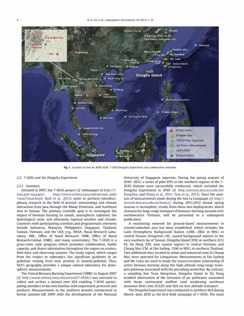
In recent years, several international and national field experi-ments such as INDOEX (Ramanathan et al., 2001a, 2001b), ACE-Asia(Huebert et al., 2003), TRACE-P (Jacob et al., 2003), APEX (Nakajimaet al., 2003), PEACE (Kondo et al., 2004), ABC (Ramanathan et al.,2007), and EAREX (Nakajima et al., 2007) have been conducted inAsia, to characterize aerosols and precursor trace gases, as well asstudy their environmental and climatic effects. For example, Asianaerosols were generally found to be a mixture of anthropogenic airpollutants and mineral dust particles in spring season, causing astrong negative surface radiative forcing (e.g., Nakajima et al.,2007). Only very limited regional campaigns (e.g., TRACE-P, Jacobet al., 2003) were focused on biomass-burning aerosols in SEA.More recently, BASE-ASIA (Tsay et al., 2013) and 7-SEAS/DongshaExperiment (Wang et al., 2011, 2013b) characterized the chemical,physical, optical, and radiative properties of biomass-burningaerosols and related air pollutants over the northern SEA. Fig. 1shows the site locations of BASE-ASIA and 7-SEAS/DongshaExperiment and collaborating networks. Table 1 further lists moredetailed information of site location and type of measurements atindividual sites. The instrumentation, deployment, and objectivesof these two experiments are related to the broader 7-SEAS project,which are described briefly below.
2.1. BASE-ASIA
Located at Phimai on a vast agricultural plain in central Thailand,the BASE-ASIA campaign was conducted late February to early Mayin 2006 which corresponds to the monsoonal dry season and amaximum in agricultural and forest fire activity (e.g., Giglio et al.,2006; Reid et al., 2005a, 2013; Tsay et al., 2013). In addition tothe major objective of extending the current understanding of howbiomass-burning aerosols affect atmospheric remote sensing andradiative energetics, BASE-ASIA provided an essential foundation inregional capacity building (Tsay et al., 2013).
NASA’s COMMIT mobile laboratory as well as instrumentationfor aerosol composition fromUniversity of Hawaii were deployed atthe Phimai observatory and radar station (15.18�N, 102.56�E, 206 mMSL), which is operated by Thailand’s Bureau of Royal Rainmakingand Agricultural Aviation. Thus, comprehensive surface measure-ments of various trace-gas concentrations, aerosol chemical/microphysical/optical properties, and meteorological parameterswere acquired (cf. Table S1 of Tsay et al., 2013 for a detailed listing ofthe remote sensors and in-situ instruments). Because Phimai isrelatively distant from the major transport routes of biomass-burning emissions from the northern region of SEA, BASE-ASIAmeasurements at Phimai often represent typical local backgroundconditions. Phimai is under the influence of prevailing northeastflow fromNovember to mid-March and southwest monsoonal flowfrom mid-May to September, seasonal aerosol loadings at Phimaiconsist of local biomass-burning smoke and anthropogenic aero-sols transported from distant sources.
N.-H. Lin et al. / Atmospheric Environment 78 (2013) 1e19 3
2.2. 7-SEAS and the Dongsha Experiment
2.2.1. SummaryInitiated in 2007, the 7-SEAS project (cf. whitepaper in http://7-
seas.gsfc.nasa.gov/; http://www.nrlmry.navy.mil/aerosol_web/7seas/7seas.html; Reid et al., 2013) seeks to perform interdisci-plinary research in the field of aerosolemeteorology and climateinteraction from Java through the Malay Peninsula, and SoutheastAsia to Taiwan. The primary scientific goal is to investigate theimpact of biomass burning on clouds, atmospheric radiation, thehydrological cycle, and ultimately regional weather and climate.Countries with participating scientists and programmatic elementsinclude Indonesia, Malaysia, Philippines, Singapore, Thailand,Taiwan, Vietnam, and the USA (e.g., NASA; Naval Research Labo-ratory, NRL; Office of Naval Research, ONR; Office of NavalResearch-Global, ONRG; and many universities). The 7-SEAS is agrass-roots style program which promotes collaboration, buildscapacity, and shares information throughout the region on science,field data, and observing systems. The study region, which rangesfrom the tropics to subtropics, has significant gradients in airpollution varying from near pristine to heavily-polluted. Thus,SEA’s geography provides a unique natural laboratory for atmo-spheric measurements.
The Virtual Biomass Burning Experiment (VBBE) in August 2007(cf. http://www.nrlmry.navy.mil/aerosol/7-SEAS/) was executed tocollect and archive a dataset over SEA enabling 7-SEAS partici-pating members to become familiar with experiment protocols andproducts. Measurements in the southern domain commenced inboreal summer-fall 2009 with the development of the National
University of Singapore supersite. During the spring seasons of2010e2012, a series of pilot IOPs in the northern regions of the 7-SEAS domain were successfully conducted, which included theDongsha Experiment in 2010 (cf. http://aerosol.atm.ncu.edu.tw/DongSha/ and Wang et al., 2011; Tsay et al., 2013). Since the anal-ysis of measurements made during the Son La Campaign (cf. http://aerosol.atm.ncu.edu.tw/SonLa/) during 2011/2012 boreal springseasons is incomplete, results from these two deployments, whichcharacterize long-range transport of biomass-burning aerosols overnorthwestern Vietnam, will be presented in a subsequentpublication.
A monitoring network for ground-based measurements inremote/suburban area has been established, which includes theLulin Atmospheric Background Station (LABS, 2862 m MSL) incentral Taiwan, Hengchun (HC, coastal background station) in thevery southern tip of Taiwan, Dongsha Island (DSI) in northern SCS/ES, Da Nang (DN, near coastal region) in central Vietnam, andChiang Mai (CM, at Doi Suthep, 1396 m MSL) in northern Thailand.Two additional sites, located in urban and industrial zone in ChiangMai, were operated for comparison. Measurements at Doi Suthepand Mt. Lulin are used to study the source/receptor relationship ofactive biomass burning along the high-altitude long-range trans-port pathway associated with the prevailing westerlies. By contrast,a sampling line from Hengchun, Dongsha Island to Da Nangenabled observation of the intrusion of air pollutants associatedwith Asian continental outflow (and weakening northeastmonsoon flow) into SCS/ES and SEA via low-altitude transport.
The Dongsha Experiment was conducted in northern SEA duringMarcheJune 2010 as the first field campaign of 7-SEAS. The main
Fig. 1. Location of sites for BASE-ASIA, 7-SEAS/Dongsha Experiment and collaborative networks.
N.-H. Lin et al. / Atmospheric Environment 78 (2013) 1e194
goals of the Dongsha Experiment were to develop Dongsha Island(about 2 km2, 20�4205200N, 116�4305100E) in the SCS/ES as an atmo-spheric observation platform for atmospheric chemistry, radiationand meteorology, and to characterize the chemical and physicalproperties of biomass burning aerosols from the northern SE Asianregion. In addition to the five primary sites listed above and twocomplimentary sites, the Mobile Air Quality Station of Taiwan EPAand NASA/COMMIT were shipped to Dongsha Island for continuousmeasurements of CO, SO2, NOx, HC, O3, aerosol particles, and
aerosol optical properties and vertical profiles. Two IOPs wereconducted, one during 14e30 March and the other 10e20 April2010. Aerosol chemistry and air toxics instrumentation deployed atfive sites are listed in Table S1. Detailed descriptions of the in-struments deployed at DSI and LABS are listed in Tables S2 and S3,respectively. Concurrent with IOP-1, the Taiwanese R/V OceanResearch No. 1 (ORO) cruised from southern Taiwan to SCS/ESduring 14e19 March. Sounding balloon launches were increased to4 times per day at Dongsha Island.
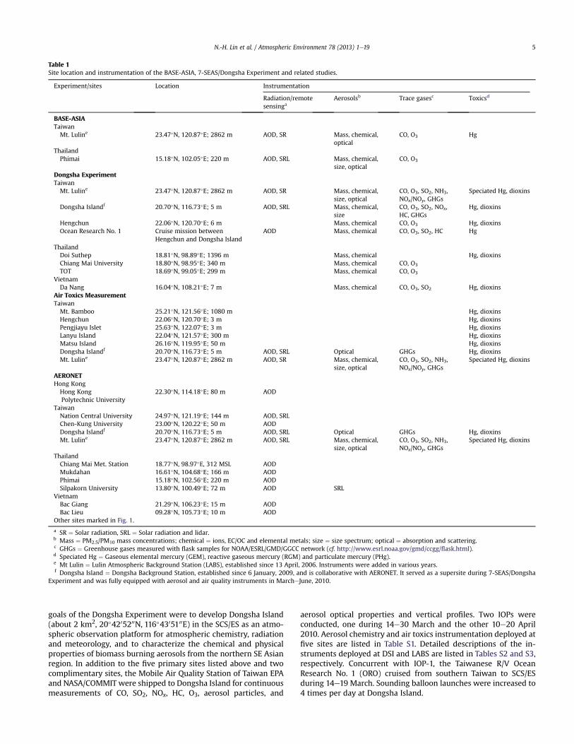
Table 1Site location and instrumentation of the BASE-ASIA, 7-SEAS/Dongsha Experiment and related studies.
Experiment/sites Location Instrumentation
Radiation/remotesensinga
Aerosolsb Trace gasesc Toxicsd
BASE-ASIATaiwanMt. Luline 23.47�N, 120.87�E; 2862 m AOD, SR Mass, chemical,
opticalCO, O3 Hg
ThailandPhimai 15.18�N, 102.05�E; 220 m AOD, SRL Mass, chemical,
size, opticalCO, O3
Dongsha ExperimentTaiwanMt. Luline 23.47�N, 120.87�E; 2862 m AOD, SR Mass, chemical,
size, opticalCO, O3, SO2, NH3,NOx/NOy, GHGs
Speciated Hg, dioxins
Dongsha Islandf 20.70�N, 116.73�E; 5 m AOD, SRL Mass, chemical,size
CO, O3, SO2, NOx,HC, GHGs
Hg, dioxins
Hengchun 22.06�N, 120.70�E; 6 m Mass, chemical CO, O3 Hg, dioxinsOcean Research No. 1 Cruise mission between
Hengchun and Dongsha IslandAOD Mass, chemical CO, O3, SO2, HC Hg
ThailandDoi Suthep 18.81�N, 98.89�E; 1396 m Mass, chemical Hg, dioxinsChiang Mai University 18.80�N, 98.95�E; 340 m Mass, chemical CO, O3
TOT 18.69�N, 99.05�E; 299 m Mass, chemical CO, O3
VietnamDa Nang 16.04�N, 108.21�E; 7 m Mass, chemical CO, O3, SO2 Hg, dioxins
Air Toxics MeasurementTaiwanMt. Bamboo 25.21�N, 121.56�E; 1080 m Hg, dioxinsHengchun 22.06�N, 120.70�E; 3 m Hg, dioxinsPengjiayu Islet 25.63�N, 122.07�E; 3 m Hg, dioxinsLanyu Island 22.04�N, 121.57�E; 300 m Hg, dioxinsMatsu Island 26.16�N, 119.95�E; 50 m Hg, dioxinsDongsha Islandf 20.70�N, 116.73�E; 5 m AOD, SRL Optical GHGs Hg, dioxinsMt. Luline 23.47�N, 120.87�E; 2862 m AOD, SR Mass, chemical,
size, opticalCO, O3, SO2, NH3,NOx/NOy, GHGs
Speciated Hg, dioxins
AERONETHong KongHong KongPolytechnic University
22.30�N, 114.18�E; 80 m AOD
TaiwanNation Central University 24.97�N, 121.19�E; 144 m AOD, SRLChen-Kung University 23.00�N, 120.22�E; 50 m AODDongsha Islandf 20.70�N, 116.73�E; 5 m AOD, SRL Optical GHGs Hg, dioxinsMt. Luline 23.47�N, 120.87�E; 2862 m AOD, SRL Mass, chemical,
size, opticalCO, O3, SO2, NH3,NOx/NOy, GHGs
Speciated Hg, dioxins
ThailandChiang Mai Met. Station 18.77�N, 98.97�E, 312 MSL AODMukdahan 16.61�N, 104.68�E; 166 m AODPhimai 15.18�N, 102.56�E; 220 m AODSilpakorn University 13.80�N, 100.49�E; 72 m AOD SRL
VietnamBac Giang 21.29�N, 106.23�E; 15 m AODBac Lieu 09.28�N, 105.73�E; 10 m AOD
Other sites marked in Fig. 1.
a SR ¼ Solar radiation, SRL ¼ Solar radiation and lidar.b Mass ¼ PM2.5/PM10 mass concentrations; chemical ¼ ions, EC/OC and elemental metals; size ¼ size spectrum; optical ¼ absorption and scattering.c GHGs ¼ Greenhouse gases measured with flask samples for NOAA/ESRL/GMD/GGCC network (cf. http://www.esrl.noaa.gov/gmd/ccgg/flask.html).d Speciated Hg ¼ Gaseous elemental mercury (GEM), reactive gaseous mercury (RGM) and particulate mercury (PHg).e Mt Lulin ¼ Lulin Atmospheric Background Station (LABS), established since 13 April, 2006. Instruments were added in various years.f Dongsha Island ¼ Dongsha Background Station, established since 6 January, 2009, and is collaborative with AERONET. It served as a supersite during 7-SEAS/Dongsha
Experiment and was fully equipped with aerosol and air quality instruments in MarcheJune, 2010.
N.-H. Lin et al. / Atmospheric Environment 78 (2013) 1e19 5
Flask samples of whole air were collected weekly using two 2 Lglass flasks along with a portable sampling unit (PSU) at DSI andLABS starting in March 2010 and August 2006, respectively. Thesesamples were analyzed by the NOAA/ESRL/GMD/Carbon CycleGreenhouse Gases Group (CCGG) in a manner identical to samplesfrom their other network sites. Detailed descriptions of the sam-pling and analytical methods can be found on the NOAA/ESRL/GMDwebpage (cf. http://www.esrl.noaa.gov/gmd/ccgg/flask.html).
2.2.2. Air Toxics MeasurementThe Air Toxics Measurement (ATM) project funded by Taiwan
EPA was established in 2008. Atmospheric mercury and dioxinswere measured in remote areas and islands in and around Taiwan.Fig. 1 shows the location of six remote sampling sites (Chi et al.,2013). Samples were intentionally collected during southwest andnortheast monsoon flow. At the same time, samples were collectedat LABS to enable comparison between the boundary layer and theLFT (Chi et al., 2010; Sheu et al., 2010). The site at ATM was oper-ational during 7-SEAS/Dongsha Experiment.
2.2.3. Space-borne remote sensing and regional surface networksThe NASA/EOS program (cf. http://eospso.gsfc.nasa.gov/, EOS
Mission Profiles for details of satellite and instrumentation), polar-orbiting satellites/sensors (e.g., SeaWiFS, Terra, EO-1, Aqua, ICESat,OMI, POLDER, CALIPSO, and Suomi NPP) provided comprehensivemeasurements of regional aerosol properties during BASE-ASIA and7-SEAS operations. In addition, international and regional ground-based networks also provide data, which enrich the studies ofbiomass-burning aerosols in SEA. These networks include: AERONET(cf. http://aeronet.gsfc.nasa.gov/ and Holben et al.,1998), MPLNET (cf.http://mplnet.gsfc.nasa.gov/ and Welton et al., 2001), SKYNET (cf.http://atmos.cr.chiba-u.ac.jp/ and Sano et al., 2003), Silpakorn Uni-versity’s Solar Radiation Monitoring Network (Janjai et al., 2009,2012), and the ABC Project (Ramanathan et al., 2007) sites in the re-gion supported by the United Nations Environment Programme.
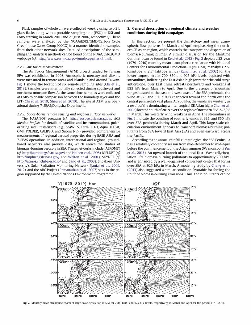
3. General description on regional climate and weatherconditions during field campaigns
In this section, we present the climatology and mean atmo-spheric flow patterns for March and April emphasizing the north-ern SE Asian region, which controls the transport and dispersion ofbiomass-burning plumes. A similar discussion for the MaritimeContinent can be found in Reid et al. (2012). Fig. 2 depicts a 32-year(1979e2010) monthly mean atmospheric circulation with NationalCenters for Environmental PredictioneII (NCEP-II) reanalysis 2.5�
longitude � 2.5� latitude winds (Kanamitsu et al., 2002) for thelower troposphere at 700, 850 and 925 hPa levels, depicted withstreamlines, indicating the East Asian high (or rather the cold surgeanticyclone) over East China retreats northward and weakens at925 hPa from March to April. Due to the presence of mountainranges located at the east and west coast of the SEA peninsula, thewind at 925 and 850 hPa is channeled toward the north over thecentral peninsula’s vast plain. At 700 hPa, the winds are westerly asa result of the dominating winter tropical SE Asian high (Chen et al.,2002) located south of 20�Nover the region of northern SEA-SCS/ESin March. This westerly wind weakens in April. The streamlines inFig. 2 indicate the coupling of southerly winds at 925, and 850 hPaover SEA peninsula during March and April. This large-scale cir-culation environment appears to transport biomass-burning pol-lutants from SEA toward East Asia (EA) and even eastward acrossthe Pacific.
According to the annual rainfall climatologies, the SEA Peninsulahas a relatively cooler dry season frommid-December to mid-Aprilbefore the commencement of the Asian summer SWmonsoon (Yenet al., 2013). An upward branch of the local EasteWest cell/circu-lation lifts biomass-burning pollutants to approximately 700 hPa,and is enhanced by a well-organized convergent center that formsover SEA at 925-hPa in March. A modeling study by Cheng et al.(2013) also suggested a similar condition favorable for forcing theuplift of biomass-burning emissions. Thus, these pollutants can be
Fig. 2. Monthly mean streamline charts of large-scale circulation in SEA for 700-, 850-, and 925-hPa levels, respectively, in March and April for the period 1979e2010.
N.-H. Lin et al. / Atmospheric Environment 78 (2013) 1e196
further transported downwind to the east at high-altitudes in thevicinity of Taiwan (Wai et al., 2008; Sheu et al., 2010; Lee et al.,2011; Ou-Yang et al., 2012; Chuang et al., 2013a; Chang et al., 2013).
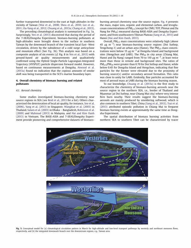
The preceding climatological analysis is summarized in Fig. 3a.Surprisingly, Yen et al. (2013) discovered that during the period ofthe 7-SEAS/Dongsha Experiment, biomass-burning pollutants athigh-altitudes were brought down to the surface in southernTaiwan by the downward branch of the transient local EasteWestcirculation, driven by the subsidence of a cold surge anticycloneand mountain effect (See Fig. 3b). This analysis was based on acomposite analysis of six events (cf. Fig. 8 in Yen et al., 2013) withground-based air quality measurements and qualitativelyconfirmed using the Hybrid Single-Particle Lagrangian-IntegratedTrajectory (HYSPLIT) particle dispersion forward model. However,based on continuous measurements at Dongsha, Atwood et al.(2013a) found no indication that the copious amounts of smokealoft was being transported in the SCS’s marine boundary layer.
4. Overall chemistry of biomass burning and relatedpollutants
4.1. Aerosol chemistry
Some studies investigated biomass-burning chemistry nearsource regions in SEA (see Reid et al., 2013 for a list). Others char-acterized the deterioration of local air quality, for instance, See et al.(2006), Yang et al. (2013) in Singapore, Wangkiat et al. (2003) inThailand, Salam et al. (2003) in Dhakae Bangladesh, Robinson et al.(2009) and Mahmud (2013) in Malaysia, and Hai and Kim Oanh(2013) in Vietnam. The BASE-ASIA and 7-SEAS/Dongsha Experi-ment provide pioneering and comprehensive datasets of biomass-
burning aerosol chemistry near the source region. Fig. 4 presentsthe mass, major ions, organic and elemental carbon, and levoglu-cosan concentrations of PM2.5 (except for CMU, TOT, Phimai and DaNang for PM10) measured during BASE-ASIA and Dongsha Experi-ment, and from southeastern Tibetan Plateau (Sang et al., 2013) andHanoi (Hai and Kim Oanh, 2013).
Overall, PM2.5 mass concentrations were relatively high (above45 mg m�3) near biomass-burning source regions (Doi Suthep,Tengchong-1) and an urban area (Hanoi). The PM2.5 mass concen-trations were below 15 mg m�3 at Dongsha Island and backgroundsites (Hengchun and LABS). The PM10 in city areas (Chiang Mai,Hanoi and Da Nang) ranged from 70 to 110 mg m�3, at least twicemore than those in remote and background sites. The ratios ofPM2.5/PM10 were greater than 0.70 for Doi Sethup and Hanoi, whilebelow 0.45 for Dongsha Island and Hengchun, indicating that fineparticles for the former were elevated due to the proximity ofburning source(s) and/or secondary aerosol formation. This ratiowas close to unity for LABS. Evidently, fine particles accounted formost of aerosol mass at LABS during the biomass burning season.
To our knowledge, Chuang et al. (2013a) is the first study tocharacterize the chemistry of biomass-burning aerosols near thesource region in the northern SEA, i.e., border of Thailand andMyanmar (at Doi Suthep, near Chiang Mai city) where very intensefires burn nearby. Their results suggest the biomass-burningaerosols are mainly produced by smoldering softwood, which isalso common in southern Tibet, China (Sang et al., 2013). Tsai et al.(2013) attributed episodic pollution in Chiang Mai to frequentbiomass burning events at approximately the same time as Dong-sha Experiment.
The spatial distribution of biomass burning activities fromnorthern SEA to southern Tibet can be characterized by tracer
Fig. 3. Conceptual model for (a) climatological circulation pattern in March for high-altitude and low-level transport pathways by westerly and northeast monsoon flows,respectively, and (b) the integrated downwash branch over the downstream regions, e.g., Taiwan area.
N.-H. Lin et al. / Atmospheric Environment 78 (2013) 1e19 7
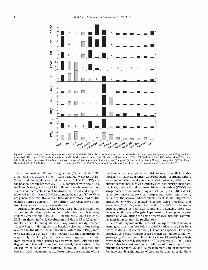
species, for instance, Kþ and levoglucosan (Cachier et al., 1991;Simoneit and Elias, 2001). The Kþ was substantially elevated at DoiSuthep and Chiang Mai city, as shown in Fig. 4. The Kþ in PM2.5 atthe near-source site reached 2.5 � 0.3%, compared with about 1.5%in Chiang Mai city, and about 1.1% in Hanoi where biomass burningsources are the combustion of hardwood, softwood, and crop res-idue (Hai and Kim Oanh, 2013). In contrast, the ratios of Kþ to PM2.5are generally below 1.0% for most field and laboratory studies. Thebiomass-burning aerosols in the northern SEA obviously distinctfrom those measured in previous studies.
Among anhydrosugar species, levoglucosan has been confirmedas the most abundant species in biomass-burning aerosols in manystudies (Simoneit and Elias, 2001; Engling et al., 2006; Pio et al.,2008). As shown in Fig. 4, levoglucosan in PM2.5 is 1.2 � 0.5 mg m�3
for Doi Suthep. In Chiang Mai city, levoglucosan in PM10 reached1.2 � 0.5 mg m�3 during biomass burning episodes. In Tengchong,over the southeastern Tibetan Plateau, levoglucosan in PM2.5 were0.7� 0.3 and 0.2� 0.1 mgm�3 at amountain site and a suburban site,respectively. The levoglucosan concentrations appear to decreasefrom biomass burning sources to downwind areas. Although thedegradation of levoglucosan has been widely hypothesized to becaused by oxidation with hydroxyl radical (OH) (Holmes andPetrucci, 2007; Hoffmann et al., 2010), direct observations of this
reaction in the atmosphere are still lacking. Nevertheless, thismechanismmayexplain certainpart of productionof organic carbon,for example the humic-like substances (Schmidl et al., 2008). Otherorganic compounds such as dicarboxylates (e.g., oxalate, malonate,succinate, glutarate) and water-soluble organic carbon (WSOC) arealso produced in biomass-burning aerosols (Yang et al., 2013).WSOCin aerosols may enhance cloud droplet production and growth,enhancing the aerosol indirect effect. Recent studies suggest theproduction of WSOC is related to aerosol aging (Aggarwal andKawamura, 2009; Miyazaki et al., 2009). The WSOC in biomass-burning aerosols at both near-source and downwind areas wasdetermined during the Dongsha Experiment to investigate the pro-duction of WSOC during the aging process (Lee, personal commu-nication, in preparation for publication).
Particulate organic matter accounts for up to 85% of biomassburning particle mass (see Reid et al., 2005b; Akagi et al., 2011 for alist of studies). Organic carbon (OC) contains species like anhy-drosugars and water-soluble species which can influence the hy-groscopicity. Furthermore, elemental carbon (EC) usually has a highcorrespondencewith black carbon (BC) (Lavanchy et al., 1999). ThusEC can also be considered as an indicator of absorption of solarradiation. Therefore, OC and EC measurements are of importancefor understanding the impact of biomass-burning aerosols. Fig. 4
Suthep
CMU
TOT
Phimai
Tengchong-1
Tengchong-2
Hanoi
DaNang
Dongsha-1
Dongsha-2
Dongsha-3
OceanOne
Hengchun
Lulin
0
50
100
PM10
0
40
80
PM2.5
0
5
10
15
SO4
2-
0
2
4
6
NO3
-
0
4
8
NH4
+
0
1
K+
0.0
0.5
1.0
LEVO
0
2
4EC
0
10
OC
0
5
10
15
X
X
X
X
XX
X
XX
X
X
XX
XX
X
X
X
XXXXX
XX
XX
XOC/EC
X
X X
X
XX
Fig. 4. Comparison of aerosol chemistry measured at sites of BASE-ASIA, 7-SEAS/Dongsha Experiment, and related studies. Black and gray histograms represent PM2.5 and PM10,respectively. Unit: mg m�3. ‘X’ stands for no data available for that species. Suthep (near BB source): Chuang et al. (2013a); CMU (urban site) and TOT (industrial site): Tsai et al.(2013); Dongsha-1 (air masses from Asian continent), Dongsha-2 (air masses from Philippine) and Dongsha-3 (air masses from Pacific Ocean): Chuang et al. (2013b); Hanoi:Hai and Kim Oanh (2013); Lulin: Lee et al. (2011) ; Hengchun: Tsai et al. (2012); Tengchong-1 (suburban site) and Tengchong-2 (mountain site): Sang et al. (2013).
N.-H. Lin et al. / Atmospheric Environment 78 (2013) 1e198
shows OC and EC are abundant in SEA and the southern China, butmuch less abundant outside SEA. In Fig. 4, the ratios of OC/EC werehigher in SEA during Dongsha Experiment than other places, exceptat LABS, suggesting that LABS is affected by biomass-burningemissions from SEA. Besides, biomass-burning aerosols are highlyrelated to the formation of clouds (Hsu et al., 2003). As described inReid et al. (2005b, 2013), there are significant amounts of sulfate inbiomass-burning aerosols, which is very hygroscopic. Indeed, thesmall inorganic fraction of smoke particle mass is seen as the bestindicator of particle hygroscopicity (Carrico et al., 2010). Sulfatetogether with other water-soluble ions like ammonium and nitrateobserved in Hanoi were higher than other locations (Fig. 4)implying the urban and industrial sources of hygroscopic aerosols isgreater than that from biomass burning during the wintertime inHanoi.
The biomass-burning plume from northern SEA was sampled atseveral locations along the transport pathway. Plume signatureswere observed at LABS in central Taiwan (Lee et al., 2011), aboveboundary layer over Hong Kong (Chan et al., 2003; Deng et al.,2008), and possibly even near the surface in the southern Taiwan(Tsai et al., 2012; Yen et al., 2013). Modeling studies by Tang et al.(2003), Satake et al., 2004, Verma et al., 2009, and Fu et al. (2012)suggested SEA to EA biomass burning emissions can spread oversoutheastern China, SCS/ES, and migrate to Central Pacific, or shiftto northeastern China, even to Japan. Wang et al. (2007) modeledthe radiative forcing of these biomass-burning aerosols in March of2001 during the TRACE-P experiment. The monthly mean clear-skydirect shortwave radiative forcing ranged from�1.9 to 0.4Wm�2 atthe top of the atmosphere and from �0.5 to �12.0 W m�2 at thesurface, resulting in an increase in the atmospheric heating ratefrom 0.01 to 0.3 �C day�1. Atwood et al. (2013a) inferred thebiomass-burning plume was transported aloft over the boundarylayer from northern Vietnam and Dongsha Island, to Taiwan. Thusthe near-surface aerosol concentrations observed at Dongsha Islandwere relatively unaffected by biomass burning during the experi-ment. This observation is consistent with Chuang et al. (2013b) whonoted biomass tracer Kþ was hardly ever observed at Dongsha Is-land during the 7-SEAS experiment. Nevertheless, Tsai et al. (2012)observed the biomass-burning plume from SEA can impact airquality in the southern Taiwan, which was confirmed by Yen et al.(2013) for the cold surge events.
Aside from the transport of biomass-burning plume by high-altitude westerly winds, air masses traveling into SCS/ES via low-level transport (See Fig. 3) have significantly different characteris-tics. Air quality and atmospheric chemistry are rarely investigated inthis oceanic region. Zhang et al. (2007) reported water-soluble ionsand trace elements in atmospheric aerosols collected during twocruise missions in northern SCS/ES in 2003. Hsu et al. (2007) inves-tigated marine aerosol during the northeastern monsoon on twowintertime cruises between Taiwan and Dongsha Island, suggestingthat massive amounts of air pollutants from China and South Asia/SEA affected air quality in SCS/ES. They foundnearly 90% chlorine lossfrom marine aerosol. Similar chlorine loss was also found for OROcruise mission during the Dongsha Experiment. The high chlorineloss is due to heterogeneous reactions between sea salt aerosols andnitric and sulfuric acids produced by anthropogenic sources. Forcomparison, Chuang et al. (2013b) found chlorine loss at DongshaIsland to be about 70% for PM2.5. This difference may result from themeasurement locations for Hsu et al. (2007) being nearer anthro-pogenic sources.
Fig. 4 shows the PM2.5 chemistry for Dongsha-1 (Asian source)and �2 (Philippine source) (Chuang et al., 2013b), ORO (NNW andSW airflows were prevailing for the first and second half periodduring 7-day cruise mission, respectively), and HC (NE and SWairflows were prevailing during two IOPs) are similar, particularly
for aerosol mass and most of water-soluble ions, while weresignificantly lower than those measured in SEA. In contrast, PM2.5mass (w7 mg m�3, on average) and all chemical compositions forDongsha-3 (which is associated with clean air mass from WestPacific) were about 40e60% of the aforementioned measurementsin SCS/ES and the southern Taiwan. For the above studies in thenorthern SCS/ES, the observed acidic pollutants represent the ma-jor anthropogenic contaminants to the region, especially sulfate(SO4
2�). On average, SO42� ions were 4.4 and 12.3 mg m�3 during two
cruises near the coast of the southern China (Zhang et al., 2007);1.4e6.4 mg m�3 during wintertime (Hsu et al., 2007) and 4.2e6.7 mgm�3 during springtime (this study) ORO cruise missions; and1.3e5.5 mg m�3 at Dongsha Island (Chuang et al., 2013b). The NO3
�
ions were nearly half of SO42� for the two cruises, reported by Zhang
et al. (2007), and only 10e20% of SO42� in the other studies. Obvi-
ously, the emissions of S and N compounds from the Chinesecontinent to SCS/ES are significant. By contrast, SO4
2� ions ranged in0.21e4.3 mg m�3 (average: 1.9 mg m�3) and were more than 3 timesNO3
� during a cruise mission in fall in Central India Ocean, repre-senting a relatively polluted condition in region (Balasubramanianet al., 2013).
The biggest dust storm on record to reach Taiwan occurredduring the Dongsha Experiment. This dust event had its genesis inChina on 19e20 March 2010 (Bian et al., 2011; Li et al., 2012), andreached the southern tip of Taiwan Island (Tsai et al., 2012) andDongsha Island (Wang et al., 2011; Chuang et al., 2013b) on 21March 2010. Both Bian et al. (2011) and Han et al. (2012) applied airquality models to simulate the dust event on 19e22 March 2010,and confirmed airborne dust can dramatically impact SCS/ES andSEA. The hourly and daily PM10 average concentrations surprisinglyreached 570 and 94.1 mg m�3, respectively (Wang et al., 2011) atDongsha Island. A number of studies suggest the events, whichtransport dust to SCS/ES, are usually accompanied by frontal pas-sages in springtime (Cohen et al., 2010; Atwood et al., 2013a). Inaddition, Asian dust was occasionally observed at Mt. Lulin incentral Taiwan during the peak of biomass burning (Lee et al., 2011)suggesting the atmospheric dust layer reaches as high as 3 km. Linet al. (2009) and Wang et al. (2012) characterized the impact ofAsian dust aerosol on biogeochemistry in SCS/ES using satellitedata. Wang et al. (2011) suggested the dust aerosols in heavy dustevents contain bioavailable iron and enhance the phytoplanktongrowth in the oligotrophic northern SCS/ES.
4.2. Trace gases
During the 7-SEAS/Dongsha Experiment, overall mean mixingratios of ozone were 44.2 ppb at LABS, 40.9 ppb at Dongsha Island,and 40.8 ppb at Hengchun (Table 2). At Chiang Mai, the sourceregion for episodic pollution (PM10 S 120 mg m�3), the mean levelof ozone was approximately 39.6 ppb and NOx 17.9 ppb (Tsai et al.,2013), typical of urban conditions. Satellite data indicates biomassburning in SEA usually peaks in March, coincident with the COseasonal maximum based on surface measurement at Srinakarin(14.36�N, 99.12�E, 296 m MSL) in rural Thailand (Pochanart et al.,2004). Ozonesonde measurements over Hong Kong as well asaircraft observations of ozone detected increases in ozone in airimpacted by biomass burning over SEA in spring during the PEM-West B (Pacific Exploratory Mission-West B) and TRACE-P (Chanet al., 2003; Kondo et al., 2004). At the LABS mountain top site,which is downwind of biomass burning emissions from SEA, theseasonal maximum of CO and ozone were regularly observed inMarch (Ou-Yang et al., 2009, 2012). However, at sea level, e.g.,Hengchun and Dongsha Island, elevated CO and ozone (i.e., 60 ppb)concentrations indicate strong northeasterly winds during thewinter Asian monsoon, which transport polluted air masses from
N.-H. Lin et al. / Atmospheric Environment 78 (2013) 1e19 9
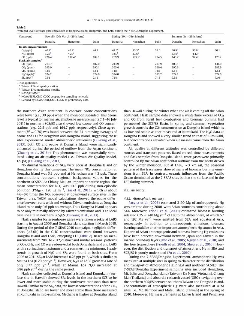
the northern Asian continent. In contrast, ozone concentrationswere lower (i.e., 30 ppb) when the monsoon subsided. This ozonelevel is typical for marine air. Shipborne measurements (11e16 July2011) in northern SCS/ES also showed low ozone and CO concen-trations (e.g., 22.5 ppb and 164.7 ppb, respectively). Close agree-ment (R2 ¼ 0.76) was found between the 24-h moving averages ofozone and CO for Hengchun and Dongsha Island, suggesting thesesites experienced similar atmospheric influences (Ou-Yang et al.,2013). Both CO and ozone at Dongsha Island were significantlyenhanced during the period of outflow from the Asian continent(Chuang et al., 2013b). This phenomenon was successfully simu-lated using an air-quality model (i.e., Taiwan Air Quality Model,TAQM) (Ou-Yang et al., 2013).
No diurnal variations of NOx were seen at Dongsha Island orHengchun during this campaign. The mean NOx concentration atDongsha Island was 3.3 ppb and at Hengchun was 4.3 ppb. Theseconcentrations represent regional background values for thenorthern SCS/ES. At Chiang Mai, an important source region, themean concentration for NOx was 19.8 ppb during non-episodicpollution (PM10 < 120 mg m�3, Tsai et al., 2013), which is about4.6e6.0 times the NOx observed at downwind surface sites in theTaiwan area. TAQM model calculations showed the ozone differ-ence between runs with and without Taiwan emissions at DongshaIsland to be only 0.6 ppb on average. Thus Dongsha Island appearsto be only minimally affected by Taiwan’s emissions and is an idealbaseline site in northern SCS/ES (Ou-Yang et al., 2013).
Flask samples for greenhouse gases were taken weekly at LABSstarting in August 2006 and Dongsha Island starting in March 2010.During the period of the 7-SEAS 2010 campaign, negligible differ-ences (<3.0%) in the GHG concentrations were found betweenDongsha Island and LABS, excepting CO (Table 2). Based on mea-surements from 2010 to 2012, distinct and similar seasonal patternsof CO2, CH4, and COwere observed at both Dongsha Island and LABSwith a springtime maximum and a summertime minimum. Steadytrends in growth of N2O and SF6 were found at both sites. From2006 to 2011, SF6 at LABS increased 0.28 ppt yr�1, which is similar toMauna Loa (0.29 ppt yr�1). However, N2O at LABS grew at a rate ofonly 0.77 ppb yr�1, while at Mauna Loa N2O increased at0.86 ppb yr�1 during the same period.
Flask samples collected at Dongsha Island and Kumukahi (sur-face site in Hawaii) showed SF6 levels in the northern SCS to belower and more stable during the southwest monsoon than nearHawaii. Similar to the SF6 data, the lowest concentrations of the CH4at Dongsha Island are lower and more stable than those measuredat Kumukahi in mid-summer. Methane is higher at Dongsha Island
than Hawaii during the winter when the air is coming off the Asiancontinent. Flask sample data showed a wintertime excess of CO2and CO from fossil fuel combustion and biomass burning hadpermeated the SCS/ES Basin. In spring and summer, vegetationgrowth controls the CO2 concentration at Dongsha Island which isas low and stable as that measured at Kumukahi. The N2O data atDongsha Island showed a very similar trend to that of Kumukahi,but concentrations elevated when air masses come from the Asiancontinent.
Air quality at different altitudes was controlled by differentsources and transport patterns. Based on real-time measurementsand flask samples from Dongsha Island, trace gases were primarilycontrolled by the Asian continental outflow from the north drivenby the winter monsoon. But at LABS, w3 km asl, the seasonalpattern of the trace gases showed signs of biomass burning emis-sions from SEA. In contrast, oceanic influences from the PacificOcean dominated at the 7-SEAS sites both at the surface and in theLFT during summer.
4.3. Air toxics
4.3.1. Atmospheric mercuryPacyna et al. (2006) estimated 2190 Mg of anthropogenic Hg
was emitted during 2000, with Asian countries contributing about54%. Moreover, Friedli et al. (2009) estimated biomass burningreleased 675 � 240 Mg yr�1 of Hg to the atmosphere, of which 57and 192 Mg yr�1 were emitted from SEA and equatorial Asia,respectively. In addition to anthropogenic emissions, biomassburning could be another important atmospheric Hg source in Asia.Exports of Asian anthropogenic and biomass-burning Hg emissionshave been detected downwind between Japan and Taiwan in themarine boundary layer (Jaffe et al., 2005; Nguyen et al., 2010) andthe free troposphere (Friedli et al., 2004; Sheu et al., 2010). How-ever, the distribution and transport of atmospheric Hg in SEA andSCS/ES is poorly understood (Fu et al., 2010).
During the 7-SEAS/Dongsha Experiment, atmospheric Hg wasmeasured at multiple sites in spring to characterize the distributionand transport of atmospheric Hg in SEA and northern SCS/ES. The7-SEAS/Dongsha Experiment sampling sites included Hengchun,Mt. Lulin and Dongsha Island (Taiwan), Da Nang (Vietnam), ChiangMai (Thailand) and aboard a research vessel (ORO) navigating overthe northern SCS/ES between southern Taiwan and Dongsha Island.Concentrations of atmospheric Hg were also measured at ATMsites, i.e., Mt. Bamboo and Matsu Island (Taiwan) in the spring of2010. Moreover, Hg measurements at Lanyu Island and Pengjiayu
Table 2Averaged levels of trace gases measured at Dongsha Island, Hengchun, and LABS during the 7-SEAS/Dongsha Experiment.
Compound Overall (10th Marche26th June) Spring (10the31st March) Summer (1ste26th June)
Dongsha Hengchun Lulin Dongsha Hengchun Lulin Dongsha Hengchun Lulin
In-situ measurementsO3 (ppb) 40.9b 40.8a 44.2 44.6b 43.3a 53.0 30.9b 30.9a 30.1NOx (ppb) 3.29b 4.29a e 3.59b 3.96a e 3.15b 4.42a e
CO (ppb) 226.4c 178.4a 189.1 259.9c 222.9a 234.5 140.2c 97.4a 120.2Flask air samplesd
CO (ppb) 213.7 e 187.0 243.9 e 227.9 109.5 e 134.0CO2 (ppm) 395.0 e 390.1 395.4 e 390.4 390.6 e 387.9CH4 (ppm) 1.86 e 1.84 1.88 e 1.85 1.81 e 1.83N2O (ppb)e 324.2 e 324.0 324.0 e 323.7 324.1 e 324.0SF6 (ppt)e 7.51 e 7.14 7.54 e 7.16 7.38 e 7.10
� Not applicable.a Taiwan EPA air quality station.b Taiwan EPA monitoring mobile.c NASA/COMMIT.d NOAA/ESRL/GMD CCGG cooperative sampling network.e Defined by NOAA/ESRL/GMD CCGG as preliminary data.
N.-H. Lin et al. / Atmospheric Environment 78 (2013) 1e1910
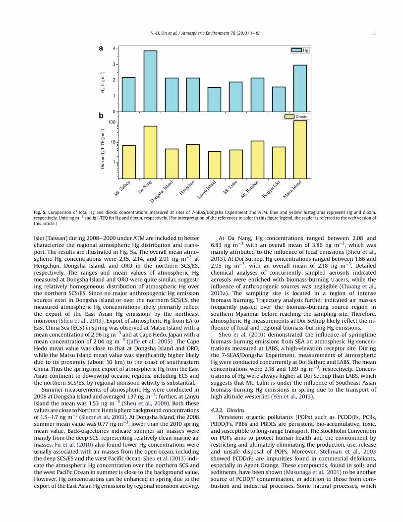
Islet (Taiwan) during 2008e2009 under ATM are included to bettercharacterize the regional atmospheric Hg distribution and trans-port. The results are illustrated in Fig. 5a. The overall mean atmo-spheric Hg concentrations were 2.15, 2.14, and 2.01 ng m�3 atHengchun, Dongsha Island, and ORO in the northern SCS/ES,respectively. The ranges and mean values of atmospheric Hgmeasured at Dongsha Island and ORO were quite similar, suggest-ing relatively homogeneous distribution of atmospheric Hg overthe northern SCS/ES. Since no major anthropogenic Hg emissionsources exist in Dongsha Island or over the northern SCS/ES, themeasured atmospheric Hg concentrations likely primarily reflectthe export of the East Asian Hg emissions by the northeastmonsoon (Sheu et al., 2013). Export of atmospheric Hg from EA toEast China Sea (ECS) in spring was observed at Matsu Island with amean concentration of 2.96 ng m�3 and at Cape Hedo, Japan with amean concentration of 2.04 ng m�3 (Jaffe et al., 2005). The CapeHedo mean value was close to that at Dongsha Island and ORO,while the Matsu Island mean value was significantly higher likelydue to its proximity (about 10 km) to the coast of southeasternChina. Thus the springtime export of atmospheric Hg from the EastAsian continent to downwind oceanic regions, including ECS andthe northern SCS/ES, by regional monsoon activity is substantial.
Summer measurements of atmospheric Hg were conducted in2008 at Dongsha Island and averaged 1.37 ng m�3; further, at LanyuIsland the mean was 1.53 ng m�3 (Sheu et al., 2009). Both thesevalues are close toNorthernHemispherebackgroundconcentrationsof 1.5e1.7 ng m�3 (Slemr et al., 2003). At Dongsha Island, the 2008summer mean value was 0.77 ng m�3, lower than the 2010 springmean value. Back-trajectories indicate summer air masses weremainly from the deep SCS, representing relatively clean marine airmasses. Fu et al. (2010) also found lower Hg concentrations wereusually associated with air masses from the open ocean, includingthe deep SCS/ES and the west Pacific Ocean. Sheu et al. (2013) indi-cate the atmospheric Hg concentration over the northern SCS andthe west Pacific Ocean in summer is close to the background value.However, Hg concentrations can be enhanced in spring due to theexport of the East Asian Hg emissions by regional monsoon activity.
At Da Nang, Hg concentrations ranged between 2.08 and6.83 ng m�3 with an overall mean of 3.86 ng m�3, which wasmainly attributed to the influence of local emissions (Sheu et al.,2013). At Doi Suthep, Hg concentrations ranged between 1.66 and2.95 ng m�3, with an overall mean of 2.18 ng m�3. Detailedchemical analyses of concurrently sampled aerosols indicatedaerosols were enriched with biomass-burning tracers, while theinfluence of anthropogenic sources was negligible (Chuang et al.,2013a). The sampling site is located in a region of intensebiomass burning. Trajectory analysis further indicated air massesfrequently passed over the biomass-burning source region insouthern Myanmar before reaching the sampling site. Therefore,atmospheric Hg measurements at Doi Sethup likely reflect the in-fluence of local and regional biomass-burning Hg emissions.
Sheu et al. (2010) demonstrated the influence of springtimebiomass-burning emissions from SEA on atmospheric Hg concen-trations measured at LABS, a high-elevation receptor site. Duringthe 7-SEAS/Dongsha Experiment, measurements of atmosphericHgwere conducted concurrently at Doi Sethup and LABS. The meanconcentrations were 2.18 and 1.89 ng m�3, respectively. Concen-trations of Hg were always higher at Doi Sethup than LABS, whichsuggests that Mt. Lulin is under the influence of Southeast Asianbiomass-burning Hg emissions in spring due to the transport ofhigh altitude westerlies (Yen et al., 2013).
4.3.2. DioxinsPersistent organic pollutants (POPs) such as PCDD/Fs, PCBs,
PBDD/Fs, PBBs and PBDEs are persistent, bio-accumulative, toxic,and susceptible to long-range transport. The Stockholm Conventionon POPs aims to protect human health and the environment byrestricting and ultimately eliminating the production, use, releaseand unsafe disposal of POPs. Moreover, Stellman et al., 2003showed PCDD/Fs are impurities found in commercial defoliants,especially in Agent Orange. These compounds, found in soils andsediments, have been shown (Masunaga et al., 2001) to be anothersource of PCDD/F contamination, in addition to those from com-bustion and industrial processes. Some natural processes, which
0
1
2
3
4a
b
Hg
(ng
m-3
)
Hg
Mt. S
uthep
Da Nan
g
Dongs
ha Is
land
Hengc
hun
Lanyu
Islan
d
Mt. L
ulin
Mt. B
ambo
o
Pengji
a Isle
t
Mats
u Isla
nd
1
10
100
Dio
xin
(fg
I-T
EQ
m-3
)
Dioxin
Fig. 5. Comparison of total Hg and dioxin concentrations measured at sites of 7-SEAS/Dongsha Experiment and ATM. Blue and yellow histograms represent Hg and dioxin,respectively. Unit: ng m�3 and fg I-TEQ for Hg and dioxin, respectively. (For interpretation of the references to color in this figure legend, the reader is referred to the web version ofthis article.)
N.-H. Lin et al. / Atmospheric Environment 78 (2013) 1e19 11
generate PCDD/Fs in small amounts, have been identified to beassociated with biomass burning (Kolenda et al., 1994). It is wellknown that the main areas of wild fires lie in the tropical and sub-tropical areas of Africa, South America, SEA, and Australia. Previousstudies also indicated (Gullett and Touati, 2003) the PCDD/Femission factor during biomass burning to range from 15 to 25 ng I-TEQ kg�1 burned. The mass-specific emissions are about 20 timeshigher than the concentration in the extracted biomass, suggestingthat PCDD/F emissions are not simply a result of vaporization ofcuticle-bound PCDD/Fs but are formed predominantly duringbiomass combustion.
Fig. 5b combines the atmospheric POPs measured (Chang et al.,2013; Chi et al., 2013; Thuan et al., 2013) at ATM and during theDongsha Experiment, illustrating the background and elevatedlevels at remote sites and source region, respectively. Thuan et al.(2013) present the first detailed measurements of atmosphericPCDD/F in central Vietnam, they report relatively high atmosphericPCDD/F concentrations (23.4e146 fg I-TEQ m�3) in Da Nang city.Additionally, significantly higher fractions of PCDDs (82 � 12%)were also observed in Da Nang city. In Vietnam, dioxin contami-nation by Agent Orange can be characterized by the predominanceof PCDDs, the contaminant of the herbicide 2,4,5-T. Hence, the highfraction of PCDDs observed in Vietnam in this study probablyoriginated as anthropogenic emission from specific sources inVietnam.
Chi et al. (2013) indicated that the highest PCDD/F concentra-tions (10.2e65.2 fg I-TEQm�3) and PCDD/F contents (132e620 pg I-TEQ/g-TSP) in ambient air were measured in northern Taiwan andat two islands in the Taiwan Strait close to mainland China duringthe northeast monsoon periods. Recent studies (Li et al., 2007a,2007b) further indicated 972e51,200 fg-I-TEQ m�3 and 223e3454 fg-I-TEQ m�3 PCDD/Fs were found in the vicinity of electronicplant wastes in Guangdong and Zhejiang provinces of China,respectively. These values are dramatically higher than othersmeasured around theworld. Since Taiwan is an island located in thesubtropics, PCDD/F concentrations should be relatively low. How-ever, in the winter and spring, Taiwan and its surrounding areas areoften influenced by northeast monsoon flow from October toMarch that originates from central Asia. Chi et al. (2013) concludethe significant increase in atmospheric PCDD/Fs measured duringthe northeast monsoon period was attributable to long-rangetransport of emissions from the coastal regions of mainland China.
Chang et al. (2013) is the first study to comprehensively explorethe long-range atmospheric transport behavior of the five groups(PCDD/Fs, PCBs, PBDD/Fs, PBBs and PBDEs) of POPs and investigatethe atmospheric characteristics of the POPs near the biomass-burning source regions of Chiang Mai in northern Thailand andDa Nang in central Vietnam along with LABS as a receptor of SEAsian biomass burning. The affected atmospheric POP concentra-tions at LABS were generally at least one order of magnitude lowerthan those in other two sites, except for elevated brominated POP(PBDD/Fs, PBBs and PBDEs) concentrations, especially PBDEs,which were attributed to biomass burning and were consideredunlikely to be related to the local use of brominated flameretardants.
During the ATM and Dongsha Experiment (Chi et al., 2013;Chang et al., 2013; Thuan et al., 2013), mean PCDD/F concentra-tions in ambient air were 13.7 and 52.2e65.2 fg I-TEQ m�3 inChiang Mai and Da Nang, respectively. These two sites weresignificantly affected by the biomass-burning and anthropogenicactivities. In contrast, the atmospheric PCDD/F concentrationsranged from 1.43 to 35.2 fg I-TEQ m�3 at the background sites inTaiwan and several remote islands in Taiwan Straight, ECS, westernPacific Ocean and SCS/ES. These concentrations were considerablylower than those measured in other Asian countries (Lee et al.,
2007; Makiya, 1999). However, the mean PCDD/F concentrationof 35.2 fg I-TEQ m�3 measured in Matsu Island in Taiwan Straight(only 10 km from Mainland China, but 210 km from Taiwan Island)was significantly higher than that measured at any other site,especially during the northeast monsoon periods. This elevatedmean PCDD/F concentration observed during the northeastmonsoon periods can be attributed to the transport of anthropo-genic emissions from mainland China. Meanwhile, atmosphericPCDD/F concentrations increased by a factor of 2e3 during theAsian dust storm event (March, 2010; see Wang et al., 2011) at thebackground site (from 3.06 increased to 6.69 fg I-TEQ m�3) atHengchun in southern Taiwan and Dongsha Island (from 1.43increased to 4.20 fg I-TEQ m�3) in SCS/ES. The PCDD/F concen-trations at these two sites were mostly unaffected by local sourcesand possibly considered as background levels. Evidently, theelevated PCDD/F concentrations should be through the long-rangetransport of Asian dust that originated from northern China andtraveled along coastal China (Wang et al., 2011). The dust particlesmixed with anthropogenic aerosols, which greatly facilitated thetransfer of PCDD/Fs emitted from local facilities in the coastal areaof China to the solid phase.
5. Aerosol physical and optical properties
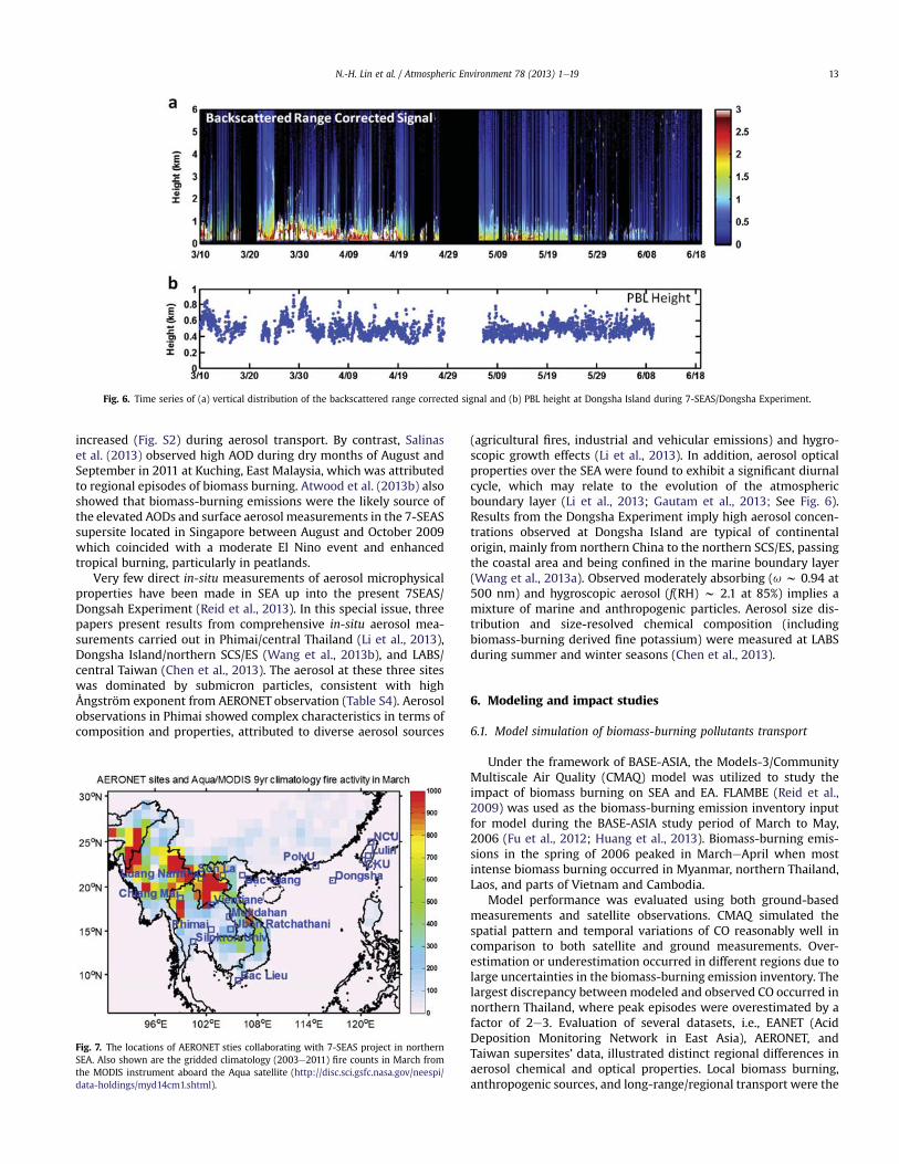
Aerosol optical and microphysical properties are important pa-rameters, which are commonly used for interpreting aerosolloading, types, and hygroscopicity, as well as to estimate aerosolradiative effects. It is valuable to link those parameters, which canbe measured in-situ, with satellite observations (Reid et al., 2013).However, the relationship between in-situ and satellite measure-ments over northern SEA is not straightforward due to the complexnature of aerosol dynamics and the dearth of in-situmeasurementsin this region (e.g., Tsay et al., 2013; Given an example as in Fig. 6).Further, consistency between in-situ measurement of bulk chem-istry, microphysical, and optical properties with a theoreticalaerosol model in the dynamic aerosol-rich environment at DongshaIsland is elusive (Bell et al., 2013). Understanding the discrepancybetween measured and modeled parameters is important foradvancing remote sensing and climate studies.
From satellite observations, the regional picture of biomassburning in northern SEA has been described. Based on analysis ofinter-annual variations of AOD and fire counts from MODIS, Hyeret al. (2013) and Gautam et al. (2013) report significant biomass-burning activities encompassing Myanmar, Laos, and Thailandusually reaching maximum intensity in March (also shown inFig. 7). A strong gradient in aerosol loading and vertical distributionwas observed over SEA from the relatively clean equatorial envi-ronment to heavy smoke-laden northern SEA (Gautam et al., 2013).Smoke near source regions was typically confined to the lower 2 kmboundary layer, but was sometimes found as high as 4 km (e.g.,Huang et al., 2011; Campbell et al., 2013; Gautam et al., 2013).
To help bring some consistency to comparisons across northernSEA, AERONET data are provided and compared to other observa-tions in the literature. Fig. 7 shows the AERONET sites (also seeFig. 1) in the 7-SEAS experimental region and gridded climatology(2003e2011) fire counts in March from theMODIS. A more detaileddiscussion of site-by-site differences can be found in Reid et al.(2013). Fig. S1 shows the monthly variations of AOD during 2008and 2010 for five selected AERONET sites. The ChiangMai, SilpakornUniversity, and Mukdahan sites are considered as source regions,while LABS and Dongsha Island are considered more remote. Wefound the five sites showed consistent seasonal variations, sug-gesting a consistent sourceereceptor relationship between thesesites. During March at Chiang Mai and LABS, AODs decreased(Fig. S1) while single scatter albedo and asymmetry parameter
N.-H. Lin et al. / Atmospheric Environment 78 (2013) 1e1912
increased (Fig. S2) during aerosol transport. By contrast, Salinaset al. (2013) observed high AOD during dry months of August andSeptember in 2011 at Kuching, East Malaysia, which was attributedto regional episodes of biomass burning. Atwood et al. (2013b) alsoshowed that biomass-burning emissions were the likely source ofthe elevated AODs and surface aerosol measurements in the 7-SEASsupersite located in Singapore between August and October 2009which coincided with a moderate El Nino event and enhancedtropical burning, particularly in peatlands.
Very few direct in-situ measurements of aerosol microphysicalproperties have been made in SEA up into the present 7SEAS/Dongsah Experiment (Reid et al., 2013). In this special issue, threepapers present results from comprehensive in-situ aerosol mea-surements carried out in Phimai/central Thailand (Li et al., 2013),Dongsha Island/northern SCS/ES (Wang et al., 2013b), and LABS/central Taiwan (Chen et al., 2013). The aerosol at these three siteswas dominated by submicron particles, consistent with highÅngström exponent from AERONET observation (Table S4). Aerosolobservations in Phimai showed complex characteristics in terms ofcomposition and properties, attributed to diverse aerosol sources
(agricultural fires, industrial and vehicular emissions) and hygro-scopic growth effects (Li et al., 2013). In addition, aerosol opticalproperties over the SEA were found to exhibit a significant diurnalcycle, which may relate to the evolution of the atmosphericboundary layer (Li et al., 2013; Gautam et al., 2013; See Fig. 6).Results from the Dongsha Experiment imply high aerosol concen-trations observed at Dongsha Island are typical of continentalorigin, mainly from northern China to the northern SCS/ES, passingthe coastal area and being confined in the marine boundary layer(Wang et al., 2013a). Observed moderately absorbing (u w 0.94 at500 nm) and hygroscopic aerosol (f(RH) w 2.1 at 85%) implies amixture of marine and anthropogenic particles. Aerosol size dis-tribution and size-resolved chemical composition (includingbiomass-burning derived fine potassium) were measured at LABSduring summer and winter seasons (Chen et al., 2013).
6. Modeling and impact studies
6.1. Model simulation of biomass-burning pollutants transport
Under the framework of BASE-ASIA, the Models-3/CommunityMultiscale Air Quality (CMAQ) model was utilized to study theimpact of biomass burning on SEA and EA. FLAMBE (Reid et al.,2009) was used as the biomass-burning emission inventory inputfor model during the BASE-ASIA study period of March to May,2006 (Fu et al., 2012; Huang et al., 2013). Biomass-burning emis-sions in the spring of 2006 peaked in MarcheApril when mostintense biomass burning occurred in Myanmar, northern Thailand,Laos, and parts of Vietnam and Cambodia.
Model performance was evaluated using both ground-basedmeasurements and satellite observations. CMAQ simulated thespatial pattern and temporal variations of CO reasonably well incomparison to both satellite and ground measurements. Over-estimation or underestimation occurred in different regions due tolarge uncertainties in the biomass-burning emission inventory. Thelargest discrepancy betweenmodeled and observed CO occurred innorthern Thailand, where peak episodes were overestimated by afactor of 2e3. Evaluation of several datasets, i.e., EANET (AcidDeposition Monitoring Network in East Asia), AERONET, andTaiwan supersites’ data, illustrated distinct regional differences inaerosol chemical and optical properties. Local biomass burning,anthropogenic sources, and long-range/regional transport were the
Fig. 7. The locations of AERONET sties collaborating with 7-SEAS project in northernSEA. Also shown are the gridded climatology (2003e2011) fire counts in March fromthe MODIS instrument aboard the Aqua satellite (http://disc.sci.gsfc.nasa.gov/neespi/data-holdings/myd14cm1.shtml).
Fig. 6. Time series of (a) vertical distribution of the backscattered range corrected signal and (b) PBL height at Dongsha Island during 7-SEAS/Dongsha Experiment.
N.-H. Lin et al. / Atmospheric Environment 78 (2013) 1e19 13
main factors controlling the aerosol chemistry. The highest con-centrations of particulate Kþ, SO4
2�, NO3�, and NH4
þwere observed atHanoi in Vietnam. Correspondingly, the model estimated thehighest AOD and AAOD (absorption AOD) at Bac Giang in Vietnam.The contribution of biomass burning to AOD was estimated to beover 56%. In Thailand, the magnitudes of major aerosol chemicalcomponents, AOD, and AAOD were much lower than in Vietnam.The contribution of biomass burning to AOD was about 18e50%.The contribution of biomass burning to AOD at Hong Kong andTaiwan was also significant (within the range of 26e62%). Theobserved monthly mean single scattering albedo was around 0.90during intense biomass-burning periods, suggesting high produc-tion of strongly absorbing substances (i.e., EC) due to biomassburning. Modeled concentrations of aerosol chemical componentswere biased low in most circumstances, and the modeled AODvalues were biased low by about a factor of 2, probably due tounderestimation of biomass burning emissions.
The Asian spring monsoon facilitated the impact of biomassburning extending from SEA to the SCS/ES, the Taiwan Strait, andsome provinces in southern China. Different spatial distributionpatterns of biomass-burning AOD between March and April werecaused by variable wind fields. In March, the average wind fields atthe latitudes of 17�Ne25�N blew primarily fromwest to east, whichcarried pollutants eastward. Below 17�N, winds blew from the eastover the western Pacific and then circulated to higher latitudeswhich formed an anticyclone, carrying large quantities of biomass-burning emissions over the SCS/ES. Biomass burning contributedabout 30e60%, 10e20%, and 20e70% to the total CO, O3 and PM2.5concentrations, respectively. In April, the wind fields changed andmostly blew from low to high latitudes, which pushed pollutantsnorth and eastward, while the SCS/ES was less impacted. Biomassburning CO reached the Yangtze River Delta with concentrations of60 ppb (10e20%). High concentrations of O3 extended farther inApril. The O3 concentration reduction ranged from 9 to 11 ppb inthe Pearl River Delta region, the Guangxi province in China, andlarge areas of the SCS/ES. PM2.5 was transported more widely andinfluenced major areas of southern China, with particulate contri-butions from biomass burning ranging from 10 to 30%.
Two intensive episodes during BASE-ASIA were furtheranalyzed. For the first episode on March 27, the influence ofbiomass burning in the source region contributed to CO, O3, andPM2.5 concentrations as high as 400 ppb, 20 ppb, and 80 mg m�3,respectively. They were reduced by 10e60%, 10e20% and 30e70%,respectively, when no biomass burning occurred. Long-rangetransport spread these pollutants over the southeastern parts ofmainland China, including the Pearl River Delta region and theFujian province in China. Biomass burning in this region resulted in160e360 ppb CO, 8e18 ppb O3 and 8e64 mg m�3 PM2.5, respec-tively; and the percentage could reach 20e50% of CO,10e30% of O3,and as high as 70% of PM2.5. During the second episode period onApril 13, transport was weaker to the southern areas of China thanthe first episode, probably reflecting differences in both biomass-burning intensity and wind patterns. The amount of biomassburning derived CO and O3 in SEA and southern China reachedapproximately 100 ppb and 6 ppb, respectively, while amount ofPM2.5 was not very significant.
Two cross-sections at 15�N and 20�N were selected to comparethe vertical flux of biomass burning. In the source region (SEA), CO,O3, and PM2.5 concentrations showed transport from the surface tohigh altitudes (Also referred to Yen et al., 2013). The transportbecame strong from 2 to 8 km in the free troposphere, and thepollutants were quickly transported eastward due to a strongwesterly. The subsidence during the long-range transport contrib-uted 60e70% CO, 20e50% O3, and 80% PM2.5, respectively, to thesurface in the downwind area.
6.2. Impact studies of biomass burning
In SEA, biomass-burning smoke often degrades air quality andalters aerosol composition. For example, Mahmud (2013) evaluatedPM10 levels in August 2004, the peak month of biomass-burningactivity, at seven air quality stations in Sarawak state that liesalong the northern coast of Borneo, Malaysia, and are locateddownwind from the centers of intensive fires. The daily averagePM10 concentration limit of 50 mg m�3 by WHOAQG (World HealthOrganization Air Quality Guidelines) was exceeded by 74e90% forsix stations, and by 29% for one station distant from the fire source.Meanwhile, relatively high AOD, greater than 0.9was detected fromthe last week of August when the intense biomass-burning activ-ities occurred in the western, central and southern Borneo.
In Singapore, particulate matter is significantly elevated bytransboundary biomass-burning smoke during peak fall season(Hyer and Chew, 2010;Wang et al., 2013a; Atwood et al., 2013b). Forexample, it increased by about 40% for both average PM2.5 and PM10mass concentrations for the one-month experiment during 8September to 5 October, 2008 (Yang et al., 2013). During the smokyperiod (19e30 September), levoglucosan exhibited an averaged154.9 ng m�3, which was around 5.6 times of its concentration(27.6 ng m�3) when smoke was absent. Similar values were foundfor 2009 (Atwood et al., 2013b). The C2eC5 total dicarboxylates(TDCAS, the sum of dicarboxylic acids (DCAs) and dicarboxylatesalts (DCS)) increased more than twofold on average. Trans-boundary smoke increasedmalic acid concentrationsmore than 3.5times, which is the largest relative increase among the measuredTDCAS. Considering that malic acid is mainly generated throughambient photooxidation, such a significant increase in malic aciddemonstrates extensive photooxidation of smoke.
Permadi and Kim Oanh (2013) estimated an emission inventoryfor biomass open burning (OB) sources including forest, agro-residue and municipal solid waste (MSW) in Indonesia for year2007, covering toxic air pollutants and greenhouse gases (GHGs). Itwas estimated that crop residue OB contributed more than 80% ofthe total biomass OB emissions, followed by forest fires at 2e12%(not including peat soil fire emission) and MSW (1e8%). The totalnet GWP (Global warming potential) of warming species frombiomass OB in the country constituted about 0.9e1.1% of that fromthe global biomass OB. BC released from OB was the third mostimportant warming agent, contributing 21% (20 year horizon) and12% (100 year horizon) of the total global warming forcing ascompared to 30 and 60%, respectively, for CO2 emissions.
Atmospheric BC emitted from SEA fires could increase Himala-yan glacier melting through BC deposition, the so-called snowdarkening effect. Yasunari et al. (2013) estimated BC dry depositionrates ranging from 270 to 4700 mg m�2 over the southern Hima-layas in spring. Results from sensitivity tests suggest the surfaceroughness parameter and wind speed are the most critical factorsin determining BC deposition rates on Himalayan glaciers.
7. Concluding remarks and perspectives
This paper has provided an overview of results from the BASE-ASIA and 7-SEAS/Dongsha Experiment and related studies fromtwenty-eight papers collected in the present special issue entitled“Observation, modeling and impact studies of biomass burning andpollution in the SE Asian Environment.” It summarizes the exper-iments and regional weather/climate, chemical characterization ofbiomass-burning aerosols and related pollutants in source and sinkregions, measurements of air toxics (atmospheric mercury and di-oxins) in source and remote areas, aerosol physical characteriza-tion, andmodeling and impact studies. Themajor scientific findingsare highlighted below:
N.-H. Lin et al. / Atmospheric Environment 78 (2013) 1e1914
1. A conceptual model of atmospheric circulation over the large-scale environment in SEA, favorable for transport of biomass-burning pollution has been constructed. The coupling south-erlies at 925 and 850 hPa levels over northern SEA duringMarch and April convey the air pollutants due to active biomassburning over SEA. Later, an upward branch of the local EasteWest longitude-height circulation is enhanced by a well-organized convergent center that forms over northern SEA at925-hPa, particularly in March, allowing the biomass-burningpollutants to be uplifted to the free troposphere and immedi-ately transported downwind to the east. Meanwhile, atmo-spheric pollutants originating from the Asian continent can beconveyed into SCS/ES and even northeastern SEA via low-leveltransport by northeast monsoon flows. Surprisingly, it is firstdiscovered that during the period of 7-SEAS/Dongsha Experi-ment, the biomass-burning pollutants at high-altitudes werebrought down to the surface of southern Taiwan by downwardbranch of the transient local EasteWest circulation, which wasinduced by the subsidence of a cold surge anticyclone. Bothsurface observations and model studies have confirmed theenhancement of local air quality in southern Taiwan.
2. The 7-SEAS/Dongsha Experiment is the first study to charac-terize the chemistry of biomass-burning aerosols near thesource region in northern SEA, and compare it with those ac-quired from concurrent measurements in background andremote sites. Overall, PM2.5 mass concentrations were relativelyhigh near burning source regions, whilemuch lower in DongshaIsland and background sites. The Kþ ion and levoglucosan, as themarkers of biomass-burning smoke, were abundant near sourceregions, while decreasing from biomass-burning sources todownwind areas. For the Dongsha Experiment, OC and EC werealso abundant in northern SEA and southern China, but muchless elsewhere. The ratios of OC/ECwere also higher in northernSEA than other places except those at LABS. The biomass-burning aerosols in northern SEA present different character-istics from previous studies in other regions.
3. During the Dongsha Experiment, the PM2.5 chemistry forbackground Dongsha Island and Hengchun sites, and onecruise mission, were similar, particularly for mass and most ofwater-soluble ions, while were significantly lower than thosemeasured in northern SEA. The observed acidic pollutantsrepresent the major anthropogenic contaminants to the region,especially sulfate (SO4
2�). A super dust storm was serendipi-tously observed to invade into SCS/ES on 21 March 2010. It wassuggested the dust aerosols in heavy dust events containreadily bioavailable iron and enhance the phytoplanktongrowth in the oligotrophic northern SCS/ES.
4. Air quality at different altitudes was dominated by differentsources during the 7-SEAS/Dongsha Experiment. Trace gases atDongsha Island were mainly affected by the Asian continentaloutflows driven by the NE monsoon flows. However, tracegases at higher altitudes, such as the elevation of LABS(w3 km), revealed signals of biomass burning arising fromnorthern SEA. At the surface sites, e.g., Hengchun and DongshaIsland, strong northeasterly winds arising from the winterAsian monsoon may have transported polluted air masses tothe northern SCS/ES, as indicated by elevated ozone levels ofapproximately 60 ppb. This level of ozone was significantlyhigher than the mean level of 39.6 ppb seen at the Chiang Maiurban site. Relatively low levels of NOx with mean concentra-tions of 3e4 ppb and the lack of distinct diurnal features wereseen at Dongsha Island and Hengchun during the campaign,representing the baseline conditions for the region of northernSCS/ES during the monsoon season. In contrast, the averageNOx level was 19.8 ppb at Chiang Mai urban site during the
non-episodic period. As a result, the NO-titration was sus-pected to be the cause of low ozone seen at the Chiang Maiurban site.
5. At LABS, situating at the downwind path of biomass burningemissions fromnorthern SEA, the seasonalmaxima of CO2, CH4,CO and ozone were repeatedly observed during March as theresult of the transport of air masses from the source region ofSEA. During the period 2006e2011, continued increase in thegrowth rates of N2O and SF6 was observed at both DongshaIsland and LABS.
6. During the Dongsha Experiment a relatively homogeneous dis-tributionofmean atmosphericHg fromsouthern tipof Taiwan tothenorthern SCS/ES, including cruisemission,weremeasured ina range of 2.0e2.15 ng m�3. This is comparable to 2.04 ng m�3
observed at Cape Hedo (Japan) in East China Sea (ECS). On theother hand, atmospheric Hg observed at Matsu Island, with amean of 2.96 ng m�3, was significantly higher than Dongshalikely due to its proximity (about 10 km) to the coast of south-eastern China. This indicates that the export of atmospheric Hgfrom the East Asian continent to the downwind oceanic regions,including ECS and the northern SCS/ES, by regional monsoonactivity is an extensive phenomenon in spring. In contrast,regional summertime atmospheric Hg concentrations over openoceans are close to the Northern Hemisphere background con-centration of 1.5e1.7 ng m�3. For northern SEA, mean Hg con-centrations measured at Da Nang and Chiang Mai were 3.9 and2.2 ng m�3, respectively, which were mainly attributed to theinfluence of regional and local emissions, particularly frombiomass-burning activities for the latter.
7. From satellite observations, significant biomass-burning ac-tivities encompassed Myanmar, Laos, and Thailand, usuallyreaching maximum intensity in March. A strong gradient inaerosol loading and vertical distributionwas observed from therelatively clean equatorial environment to heavy smoke-ladennorthern SEA. Smoke near source region was found to betypically confined to the lower 2 km boundary layer, andelevated as high as 4 km upon strongest over regional moun-tain ranges. Ground-based lidar observations at Dongsha Islandindicated that most aerosols distributed within the marineboundary layer (MBL) of around 0.5 � 0.09 km, representing atypical MBL height for a sub-tropical maritime environmentduring springtime. Meanwhile, biomass-burning aerosols fromnorthern SEA were transported in the lower free troposphere(3e4 km) over the northern SCS/ES. Further lidar parameter ofasphericity suggested these biomass-burning aerosols to bemoderately non-spherical. It was also found the stratiformclouds are prevalent in the shallow boundary layer with cloudtops at w2 km and depths of w1 km, overlaid the low-levelanthropogenic aerosol layer over the northern SCS/ES. Thecomplex vertical distributions of aerosols and clouds haveimportant implications for remote-sensing observations andatmospheric radiative transfer.
8. The CMAQ model simulation for SEA during BASE-ASIA periodindicated that the contribution of biomass burning to AOD overnorthern Vietnam was estimated to be over 56%, a significantinfluence; about 18e50% over Thailand, a moderate impact;and downwind at Hong Kong and Taiwan within the range of26e62%, a significant contribution. The modeled AOD wasbiased low about a factor of 2, probably due to the underesti-mation of biomass-burning emissions. The model resultscaptured the transport pathway of biomass-burning pollutantswell, showing that in source region the pollutants had a strongupward transport from surface to high altitudes, and werequickly transported eastward due to a strong westerly. Thesubsidence during the long-range transport contributed 60e
N.-H. Lin et al. / Atmospheric Environment 78 (2013) 1e19 15
70% CO, 20e50% O3, and 80% PM2.5, respectively, to surface inthe downwind area. Model results are evidently consistentwith the conceptual model of springtime circulation flows overthe large-scale environment in SEA we constructed, based onclimatology and observations.
We have presented our recent 7-SEAS deployments and majorscientific findings of regional biomass-burning studies that advancethe current fundamental understanding with regards to dynamical,chemical, optical, microphysical, and radiative characteristics ofaerosol and clouds over northern SEA. In conjunction with satelliteoverpasses, as elucidated in Tsay et al. (2013), the strategic de-ployments of ground-based supersites (e.g., SMARTLabs mobilelaboratories) combined with distributed networks (e.g., AERONET/MPLNET) and regional contributingmeasurements near/downwindof aerosol source regions and along transport pathways, offer asynergistic approach for further exploring many key atmosphericprocesses (e.g., complex aerosolecloud interactions) and impacts ofbiomass burning on the surfaceeatmosphere energy budgets dur-ing lifecycles from source to receptor areas. These methodologies,developed through our years of experience, serve as a call to action,baselining potential pathways to an improved understanding of theregional aerosol effects, which continue to be one of the largestuncertainties in climate forcing. The first such action is a joint in-ternational effort, named as the 7-SEAS/BASELInE (Biomass-burning Aerosols & Stratocumulus Environment: Lifecycles andInteractions Experiment), which is scheduled to commence inspringtime 2013 in northern SEA. Thus, 7-SEAS/BASELInE will focuson addressing the following key questions:
� What processes, interactions, and feedbacks control the life-cycle of biomass-burning aerosols from source to receptorregions in boreal spring Southeast Asia?
� How do droplet nucleation and the resulting products (e.g.,cloud albedo, water content, precipitation efficiency, etc.) ofwarm rain processes in the cloud-resolving model simula-tions respond with respect to key aerosol physicochemicalobservables (e.g., number/mass concentration, size/shapedistribution, and chemical composition) over a regionalscale?
� How do changes to aerosolecloud interactions in borealspring Southeast Asia provide feedbacks to regional climatethrough exchanges of energy, water, gases, and particulatematter between the surface and troposphere?
Although it is unlikely to be able to tackle all these questions inone deployment, through integrated and synthesized space-borneand ground-based measurements and comprehensive modelingefforts, 7-SEAS/BASELInE would provide a basis for a deeperimprovement of the understanding of the lifecycles of regionalbiomass-burning aerosols, and their interactions with stratocu-mulus clouds during the Asian pre-monsoon season. The resultsfrom these planned studies, in turn, would shed new light on therange of potential effects on water cycle due to regional anthro-pogenic activities.
Acknowledgments
The authors thank the continuous support by the Taiwan Envi-ronmental Protection Administration under contracts No. EPA-99-FA11-03-A097, EPA-99-U1L1-02-101, and the National ScienceCouncil of Taiwan under grant No. 98-2745-M-008-001 for the fieldoperation of Dongsha Experiment. We also thank the Deploymentsof SMARTLabs and AERONET/MPLNET in Southeast Asia, as part ofNASA Radiation Sciences Program managed by Dr. Hal B. Maring.
The authors also gratefully acknowledge the team efforts led by J.Boonjawat (Southeast Asia START Regional Center at ChulalongkornUniversity, Thailand) and K. Bhuranapanon (Head of Phimai obser-vatory and radar station, Bureau of Royal Rainmaking and Agricul-tural Aviation, Thailand) for supporting BASE-ASIA deployment, andby Anh X. Nguyen (Institute of Geophysics at Vietnam Academy ofScience and Technology, Vietnam) and Khajornsak Sopajaree(Department of Environmental Engineering, Chiang Mai University,Chiang Mai, Thailand) in supporting 7-SEAS/Dongsha Experimentover northern Southeast Asia. Taiwan EPA, Ministry of Defense,Navy, Coast Guard Administration, Marine National Park Head-quarters, and Weather Station of Taiwan Navy at Dongsha Islandprovided great logistic supports and assistance for instrument de-ployments at Dongsha Island. National Central University, NationalMuseum of Marine Biology and Aquarium, Ministry of Science andTechnology of Vietnam, Middle of Central Regional Hydro-Meteorological Observatory, National Hydro-Meteorological Ser-vice of Vietnam, and Doi Suthep-Pui National Park Protection Unit inChiang Mai, facilitated site operations at Lulin, Hengchun, Dang Naand Doi Suthep, respectively. Dr. Reid’s efforts were supported bythe Naval Research Laboratory base program. Thanks are also givento all assistants and graduate students involving in the site opera-tion, data analysis and technical support for making field campaignssuccessful.
Appendix A. Supplementary data
Supplementary data related to this article can be found at http://dx.doi.org/10.1016/j.atmosenv.2013.04.066.
References
Aditama, T.Y., 2000. Impact of haze from forest fires to respiratory health: Indonesiaexperience. Respirology 5, 169e174.
Aggarwal, S.G., Kawamura, K., 2009. Carbonaceous and inorganic composition inlong-range transported aerosols over northern Japan: implication for aging ofwater-soluble organic fraction. Atmospheric Environment 43, 2532e2540.
Akagi, S.K., Yokelson, R.J., Weidinmyer, C., Alvarado, M.J., Reid, J.S., Karl, T.,Crounse, J.D., Wennberg, P.O., 2011. Emission factors for open and domesticbiomass burning for use in atmospheric models. Atmospheric Chemistry andPhysics 11, 4039e4072. http://dx.doi.org/10.5194/acp-11-4039-2011.
Atwood, S.A., Reid, J.S., Kreidenweis, S.M., Cliff, S., Zhao, Y., Lin, N.H., Tsay, S.C.,Chu, Y.C., Westphal, D.L., 2013a. Size resolved measurements of springtimeaerosol particles over the northern South China Sea for use in source identifi-cation. Atmospheric Environment 78, 134e143.
Atwood, S.A., Reid, J.S., Kreidenweis, S.M., Yu, L.E., Salinas, S.V., Chew, B.N.,Balasubramanian, R., 2013b. Analysis of source regions for smoke events inSingapore for the 2009 El Nino burning season. Atmospheric Environment 78,219e230.
Balasubramanian, R., Qian, W.-B., Decesari, S.M.C., Facchini, M.C., Fuzzi, S., 2003.Comprehensive characterization of PM2.5 aerosols in Singapore. Journal ofGeophysical Research 108 (D16), 4523. http://dx.doi.org/10.1029/2002JD002517.
Balasubramanian, R., Karthikeyan, S., Potter, J., Wurl, O., Durville, C., 2013. Chemicalcharacterization of aerosols in the equatorial atmosphere over the India Ocean.Atmospheric Environment 78, 268e276.
Bell, S.W., Hansell, R.A., Chow, J.C., Tsay, S.-C., Hsu, N.C., Lin, N.-H., Wang, S.-H., Ji, Q.,Li, C., Watson, J.G., 2013. Constraining aerosol optical models using ground-based, collocated particle size and mass measurements in variable air massregimes during the 7-SEAS/Dongsha Experiment. Atmospheric Environment 78,163e173.
Betha, R., Pradani, M., Joshi, U.M., Reid, J.S., Balasubramanian, R., 2012. Chemicalspeciation of trace metals emitted from peat fires for health risk assessment.Atmospheric Research 122, 571e578.
Bian, H., Tie, X., Cao, J., Ying, Z., Han, S., Xue, Y., 2011. Analysis of a severe dust stormevent over China: application of the WRF-Dust model. Aerosol and Air QualityResearch 11, 419e428.
Cachier, H., Ducret, J., Brémond, M.P., Gaudichet, A., Lacaux, J.P., Yoboué, V.,Baudet, J., 1991. In: Levine, J. (Ed.), Characterization of Biomass Burning Aerosolsin a Savannah Region of the Ivory Coast, Global Biomass Burning. MIT Press,Cambridge, pp. 174e180.
Campbell, J.R., Reid, J.S., Westphal, D.L., Zhang, J., Tackett, J.L., Chew, B.N.,Welton, E.J., Shimizu, A., Sugimoto, N., Aoki, K., Winker, D.M., 2013. Character-izing the vertical profile of aerosol particle extinction and linear depolarization
N.-H. Lin et al. / Atmospheric Environment 78 (2013) 1e1916
over Southeast Asia and the Maritime Continent: the 2007e2009 view fromCALIOP. Atmospheric Research 122, 520e543.
Carrico, C.M., Petters, M.D., Kreidenweis, S.M., Sullivan, A.P., McMeeking, G.R.,Levin, E.J.T., Engling, G., Malm, W.C., Collett Jr., J.L., 2010. Water uptake andchemical composition of fresh aerosols generated in open burning of biomass.Atmospheric Chemistry and Physics 10, 5165e5178. http://dx.doi.org/10.5194/acp-10-5165-2010.
Chan, C.-Y., Chan, L.-Y., Harris, J.M., Oltmans, S.J., Blake, D.R., Qin, Y., Zheng, Y.G.,Zheng, X.D., 2003. Characteristics of biomass burning emission sources, trans-port, and chemical speciation in enhanced springtime tropospheric ozoneprofile over Hong Kong. Journal of Geophysical Research 108, D14015. http://dx.doi.org/10.1029/2001JD001555.
Chang, S.-C., Lee, W.-J., Wang, L.-C., Lin, N.-H., Chang-Chien, G.-P., 2013. Influence ofthe Southeast Asia biomass burnings on the atmospheric persistent organicpollutants observed at near source and receptor sites. Atmospheric Environ-ment 78, 184e194.
Chen, S.-C., Hsu, S.-C., Tsai, C.-J., Chou, C.C.-K., Lin, N.-H., Lee, C.-T., Roam, G.-D.,Pui, D.Y.H., 2013. Dynamic variations of ultrafine, fine and coarse particles at theLu-Lin background site in East Asia. Atmospheric Environment 78, 154e162.
Chen, T.-C., Yen, M.-C., Huang, W.-R., Gallus Jr., W.A., 2002. An East-Asian cold surge:case study. Monthly Weather Review 130, 2271e2291.
Cheng, F.-Y., Yang, Z.-M., Ou-Yang, C.-F., Ngan, F., 2013. A numerical study of thedependence of long-range transport of CO to a mountain station in Taiwan onsynoptic weather patterns during the Southeast Asia biomass-burning season.Atmospheric Environment 78, 277e290.
Chi, K.H., Lin, C.-Y., OuYang, C.-F., Wang, J.-L., Lin, N.-H., Sheu, G.-R., Lee, C.-T., 2010.PCDD/F measurement at a high-altitude station in Central Taiwan: evaluation oflong-range transport of PCDD/Fs during the Southeast Asia biomass burningevent. Environmental Science and Technology 44, 2954e2960.
Chi, K.-H., Lin, C.-Y., Wang, S.-H., Lin, N.-H., Sheu, G.-R., Lee, C.-T., 2013. Evaluation ofthe distributions of ambient PCDD/Fs at remote locations in and around Taiwan.Atmospheric Environment 78, 203e210.
Chuang, M.-T., Chou, C.-K., Sopajareepom, K., Lin, N.-H., Wang, J.-L., Sheu, G.-R.,Chang, Y.-C., Lee, C.-T., 2013a. Characterization of aerosol chemical propertiesfrom near-source biomass burning in Chiang Mai, Thailand during 7-SEAS/Dongsha experiment. Atmospheric Environment 78, 72e81.
Chuang, M.-T., Lin, N.-H., Chang, S.-C., Wang, J.-L., Sheu, G.-R., Chang, Y.-.J., Lee, C.-T.,2013b. Aerosol chemical properties and related pollutants at Dongsha Islandduring 7-SEAS/Dongsha experiment. Atmospheric Environment 78, 82e92.
Cohen, D.D., Crawford, J., Stelcer, E., Bac, V.T., 2010. Characterisation and sourceapportionment of fine particulate sources at Hanoi from 2001 to 2008. Atmo-spheric Environment 44, 320e328.
Dawud, Y., 1998. Smoke Episodes and Assessment of Health Impacts Related to Hazefrom Forest Fires: Indonesian Experience. Health Guidelines for Vegetation FireEvents, Lima, Peru, Oct 6e9, 1998; WHO, 1999.
Deng, X.J., Tie, X.X., Zhou, X.J., Wu, D., Zhong, L.J., Tan, H.B., Li, F., Huang, X.Y., Bi, X.Y.,Deng, T., 2008. Effects of Southeast Asia biomass burning on aerosols and ozoneconcentrations over the Pearl River Delta (PRD) region. Atmospheric Environ-ment 42, 8493e8501.
Engling, G., Carrico, C.M., Kreindenweis, S.M., Collet, J.L., Day, D.E., Malm, W.C.,Lincoln, E., Hao, W.M., Iinuma, Y., Herrmann, H., 2006. Determination of levo-glucosan in biomass combustion aerosol by high-performance anion-exchangechromatography with pulsed amperometric detection. Atmospheric Environ-ment 40, 299e311.
Friedli, H.R., Arellano, A.F., Cinnirella, S., Pirrone, N., 2009. Initial estimates ofmercury emissions to the atmosphere from global biomass burning. Environ-mental Science and Technology 43, 3507e3513.
Friedli, H.R., Radke, L.F., Prescott, R., Li, P., Woo, J.-H., Carmichael, G.R., 2004. Mer-cury in the atmosphere around Japan, Korea, and China as observed during the2001 ACE-Asia field campaign: measurements, distributions, sources, and im-plications. Journal of Geophysical Research 109, D19S25. http://dx.doi.org/10.1029/2003JD004244.
Fu, X., Feng, X., Zhang, G., Xu, W., Li, X., Yao, H., Liang, P., Li, J., Sommar, J., Yin, R.,Liu, N., 2010. Mercury in the marine boundary layer and seawater of the SouthChina Sea: concentrations, sea/air flux, and implication for land outflow. Journalof Geophysical Research 115, D06303. http://dx.doi.org/10.1029/2009JD012958.
Fu, J.S., Hsu, N.C., Gao, Y., Huang, K., Li, C., Lin, N.-H., Tsay, S.-C., 2012. Evaluating theinfluences of biomass burning during 2006 BASE-ASIA: a regional chemicaltransport modeling. Atmospheric Chemistry and Physics 12, 3837e3855. http://dx.doi.org/10.5194/acp-12-3837-2012.
Gautam, R., Hsu, N.C., Eck, T.F., Holben, B.N., Janjai, S., Jantarach, T., Tsay, S.-C.,Lau, W.K., 2013. Characterization of aerosols over the Indochina peninsula fromsatellite-surface observations during biomass burning pre-monsoon season.Atmospheric Environment 78, 51e59.
Giglio, L., Csiszar, I., Justice, C.O., 2006. Global distribution and seasonality of activefires as observed with the Terra and Aqua MODIS sensors. Journal ofGeophysical Research 111, G02016. http://dx.doi.org/10.1029/2005JG000142.
Gras, J.L., Jensen, J.B., Okada, K., Ikegami, M., Zaizen, Y., Makino, Y., 1999. Someoptical properties of smoke aerosol in Indonesia and tropical Australia.Geophysical Research Letters 26, 1393e1396.
Gullett, B.K., Touati, A., 2003. PCDD/F emissions from forest fire simulations. At-mospheric Environment 37, 803e813.
Hai, G.D., Kim Oanh, N.T., 2013. Effects of local, regional meteorology and emissionsources on mass and compositions of particulate matter in Hanoi. AtmosphericEnvironment 78, 105e112.
Han, X., Ge, C., Tao, J., Zhang, M., Zhang, R., 2012. Air quality modeling for a strongdust event in East Asia in March 2010. Aerosol and Air Quality Research 12,615e628.
Hoffmann, D., Tilgner, A., Hnuma, Y., Herrmann, H., 2010. Atmospheric stability oflevoglucosan: a detailed laboratory and model study. Environmental Scienceand Technology 44, 694e699.
Holben, B.N., Eck, T.F., Slutsker, I., Tanré, D., Buis, J.P., Setzer, A., Vermote, E.,Reagan, J.A., Kaufman, Y.J., Nakajima, T., Lavenu, F., Jankowiak, I., Smirnov, A.,1998. AERONETeA federated instrument network and data archive for aerosolcharacterization. Remote Sensing of Environment 66, 1e16.
Holmes, B.J., Petrucci, G.A., 2007. Oligomerization of levoglucosan by Fentonchemistry in proxies of biomass burning aerosols. Journal of AtmosphericChemistry 58, 151e166.
Hopke, P.K., Cohen, D.D., Begum, B.A., Biswas, S.K., Ni, B., Pandit, G.G., Santoso, M.,Chung, Y.-S., Davy, P., Markwitz, A., Waheed, S., Siddique, N., Santos, F.L.,Pabroa, P.C.B., Seneviratne, M.C.S., Wimolwattanapun, W., Bunprapob, S.,Vuong, T.B., Hien, P.D., Markowicz, A., 2008. Urban air quality in the Asian re-gion. Science of the Total Environment. ISSN: 0048-9697 404, 103e112. http://dx.doi.org/10.1016/j.scitotenv.2008.05.039.
Hsu, N.C., Gautam, R., Sayer, A.M., Bettenhausen, C., Li, C., Jeong, M.J., Tsay, S.-C.,Holben,B.N., 2012.Global and regional trends ofaerosoloptical depthover landandocean using SeaWiFS measurements from 1997 to 2010. Atmospheric Chemistryand Physics 12, 8037e8053. http://dx.doi.org/10.5194/acp-12-8037-2012.
Hsu, N.C., Herman, J.R., Tsay, S.-C., 2003. Radiative impacts from biomass burning inthe presence of clouds during boreal spring in Southeast Asia. GeophysicalResearch Letters 30 (5), 1224e1227.
Hsu, S.-C., Liu, S.-C., Kao, S.-J., Jeng, W.-L., Huang, Y.-T., Tseng, C.-M., Tsai, F., Tu, J.-Y.,Yang, Y., 2007. Water soluble species in the marine aerosol from the northernSouth China Sea: high chloride depletion related to air pollution. Journal ofGeophysical Research 112, D19304. http://dx.doi.org/10.1029/2007JD008844.
Huang, J., Hsu, N.C., Tsay, S.-C., Jeong, M.-J., Holben, B.N., Berkoff, T.A., Welton, E.J.,2011. Susceptibility of aerosol optical thickness retrievals to thin cirruscontamination during the BASE-ASIA campaign. Journal of GeophysicalResearch 116, D08214. http://dx.doi.org/10.1029/2010JD014910.
Huang, K., Fu, J.S., Christina Hsu, N., Gao, Y., Dong, X., Tsay, S.-C., Lam, Y.F., 2013.Impact assessment of biomass burning on air quality in Southeast and East Asiaduring BASE-ASIA. Atmospheric Environment 78, 291e302.
Huebert, B.T., Bates, T., Russell, P.B., Shi, G.Y., Kim, Y.J., Kawamura, K., Carmichael, G.,Nakajima, T., 2003. An overview of ACE-Asia: strategies for quantifying therelationships between Asian aerosols and their climatic impacts. Journal ofGeophysical Research 108 (D23), 8633e8652. http://dx.doi.org/10.1029/2003JD003550.
Hyer, E.J., Chew, B.N., 2010. Aerosol transport model evaluation of an extremesmoke episode in Southeast Asia. Atmospheric Environment 44, 1422e1427.
Hyer, E.J., Reid, J.S., Prins, E.M., Hoffman, J.P., Schmidt, C.C., Miettinen, J.I., Giglio, L.,2013. Patterns of fire activity over Indonesia and Malaysia from polar andgeostationary satellite observations. Atmospheric Research 122, 504e519.http://dx.doi.org/10.1016/j.atmosres.2012.06.011.
Ikegami, M., Okada, K., Zaizen, Y., Makino, Y., Jensen, J.B., Gras, J.L., Harjanto, H.,2001. Very high weight ratios of S/K in individual haze particles over Kali-mantan during the 1997 Indonesian forest fires. Atmospheric Environment 35,4237e4242. http://dx.doi.org/10.1016/S1352-2310(01)00247-3.
Jacob, D.J., Crawford, J.H., Kleb, M.M., Connors, V.S., Bendura, R.J., Raper, J.L.,Sachse, G.W., Gille, J.C., Emmons, L., Heald, C.L., 2003. Transport and ChemicalEvolution over the Pacific (TRACE-P) aircraft mission: design, execution, andfirst results. Journal of Geophysical Research 108, 9000e9018. http://dx.doi.org/10.1029/2002JD003276.
Jaffe, D.A., Prestbo, E.M., Swartzendruber, P.C., Weiss-Penzias, P., Kato, S., Takami, A.,Hatakeyama, S., Kajii, Y., 2005. Export of atmospheric mercury from Asia. At-mospheric Environment 39, 3029e3038.
Janjai, S., Nunez, M., Masiri, I., Wattan, R., Buntoung, S., Jantarach, T., Promsen, W.,2012. Aerosol optical properties at four sites in Thailand. Atmospheric ClimateSciences 2, 441e453.
Janjai, S., Suntaropas, S., Nunez, M., 2009. Investigation of aerosol optical propertiesin Bangkok and suburbs. Theoretical and Applied Climatology 96, 221e233.http://dx.doi.org/10.1007/s00704-008-0026-4682-691.
Kanamitsu, M., Ebisuzaki, W., Woollen, J., Yang, S.-K., Hnilo, J.J., Fiorino, M.,Potter, G.L., 2002. NCEP-DEO AMIP-II reanalysis (R-2). Bulletin of the AmericanMeteorological Society 83, 1631e1643.
Kim Oanh, N.T., Bich, T.L., Tipayarom, D., Manadhar, B.R., Prapat, P., Simpson, C.D.,Liu, L.-J.S., 2011. Characterization of particulate matter emission from openburning of rice straw. Atmospheric Environment 45, 493e502.
Kolenda, J., Gass, H., Wilken, M., Jagerc, J., Zeschmar-Lahl, B., 1994. Determinationand reduction of PCDD/F emissions from wood burning facilities. Chemosphere29, 1927e1938.
Kondo, Y., Nakamura, K., Chen, G., Takegawa, N., Koike, M., Miyazaki, Y., Kita, K.,Crawford, J., Ko, M., Blake, D.R., Kawakami, S., Shirai, T., Liley, B., Wang, Y.,Ogawa, T., 2004. Photochemistry of ozone over the western Pacific from winterto spring. Journal of Geophysical Research 109, D23S02. http://dx.doi.org/10.1029/2004JD004871.
Kunii, O., Kanagawa, S., Yajima, I., Hisamatsu, Y., Yamamura, S., Amagai, T.,Ismail, I.T.S., 2002. The 1997 haze disaster in Indonesia: its air quality and healtheffects. Archives of Environmental Health 57, 16e22.
Lavanchy, V.M.H., Gaiggeler, H.W., Nyeki, S., Baltensperger, U., 1999. Elementalcarbon (EC) and black carbon (BC) measurement with a thermal method and an
N.-H. Lin et al. / Atmospheric Environment 78 (2013) 1e19 17
aethalometer at the high-alpine research station Jungfraujoch. AtmosphericEnvironment 3, 2759e2769.
Lee, C.T., Chuang, M.T., Lin, N.H., Wang, J.L., Sheu, G.R., Wang, S.H., Huang, H.,Chen, H.W., Weng, G.H., Hsu, S.P., 2011. The enhancement of biosmokefrom Southeast Asia on PM2.5 water-soluble ions during the transport overthe Mountain Lulin site in Taiwan. Atmospheric Environment 45, 5784e5794.
Lee, S.J., Park, H., Choi, S.D., Lee, J.M., Chang, Y.S., 2007. Assessment of variations inatmospheric PCDD/Fs by Asian dust in southeastern Korea. Atmospheric Envi-ronment 41, 5876e5886.
Li, C., Tsay, S.-C., Hsu, N.C., Kim, J.Y., Howell, S.G., Huebert, B.J., Ji, Q., Jeong, M.-J.,Wang, S.-H., Hansell, R.A., Bell, S.W., 2013. Characteristics and composition ofatmospheric aerosols in Phimai, central Thailand during BASE-ASIA. Atmo-spheric Environment 78, 60e71.
Li, H., Yu, L., Sheng, G., Fu, J., Peng, P.A., 2007a. Severe PCDD/F and PBDD/F pollutionin air around an electronic waste dismantling area in China. EnvironmentalScience and Technology 41, 5641e5646.
Li, J., Wang, Z., Zhuang, G., Luo, G., Sun, Y., Wang, Q., 2012. Mixing of Asian mineraldust with anthropogenic pollutants over East Asia: a model case study of asuper-duststorm in March 2010. Atmospheric Chemistry and Physics 12,7591e7607.
Li, Y.-M., Zhang, Q.-.H., Jiang, G.-B., 2007b. Atmospheric concentrations of PCDD/Fsand PCBs in a typical e-waste processing area in China. Organohalogen Com-pounds 69, 1421e1423.
Lin, I.-I., Wong, G.T.F., Lien, C.-C., Chien, C.-Y., Huang, C.-W., Chen, J.-P., 2009. Aerosolimpact on the South China Sea biogeochemistry: an early assessment fromremote sensing. Geophysical Research Letters 36, L17605. http://dx.doi.org/10.1029/2009GL037484.
Mahmud, M., 2013. Assessment of atmospheric impacts of biomass open burning inKalimantan, Borneo during 2004. Atmospheric Environment 78, 242e249.
Makiya, K., 1999. National environmental monitoring in Japan. OrganohalogenCompounds 43, 217e220.
Masunaga, S., Takasuga, T., Nakanishi, J., 2001. Dioxin and dioxin-like PCB impuritiesin some Japanese agrochemical formulations. Chemosphere 44, 873e885.
Miyazaki, Y., Aggarwal, S.G., Singh, K., Gupta, P.K., Kawamura, K., 2009. Dicarboxylicacids and water-soluble organic carbon in aerosols in New Delhi, India, inwinter: characteristics and formation processes. Journal of GeophysicalResearch 114, D19206. http://dx.doi.org/10.1029/2009JD011790.
Nakajima, T., et al., 2003. Significance of direct and indirect radiative forcings ofaerosols in the East China Sea region. Journal of Geophysical Research 108(D23), 8658e8673. http://dx.doi.org/10.1029/2002JD003261.
Nakajima, T., Yoon, S.-C., Ramanathan, V., Shi, G.-Y., Takemura, T., Higurashi, A.,Takamura, T., Aoki, K., Sohn, B.J., Tsuruta, H., Sugimoto, N., Shimizu, A., Sawa, Y.,Lin, N.-H., Lee, C.-T., Goto, D., Yamano, M., Schutgens, N., 2007. Overview of theABC EAREX 2005 regional experiment and a study of the aerosol direct radiativeforcing in the East Asia. Journal of Geophysical Research 112, D24S91. http://dx.doi.org/10.1029/2007JD009009.
Nguyen, H.T., Kim, M.-Y., Kim, K.-H., 2010. The influence of long-range transport onatmospheric mercury on Jeju Island, Korea. Science of the Total Environment408, 1295e1307.
Okada, K., Ikegami, M., Zaizen, Y., Makino, Y., Jensen, J.B., Gras, J.L., 2001. Themixture of individual aerosol particles in the 1997 Indonesian haze episode.Journal of Aerosol Science 32, 1269e1279.
Ou-Yang, C.-F., Lin, Y.-C., Lin, N.-H., Lee, C.-T., Sheu, G.-R., Kam, S.-H., Wang, J.-L.,2009. Inter-comparison of three instruments for measuring regional back-ground carbon monoxide. Atmospheric Environment 43, 6449e6453.
Ou-Yang, C.-F., Lin, N.-H., Sheu, G.-R., Lee, C.-T., Wang, J.-L., 2012. Seasonal anddiurnal variations of ozone at a high-altitude mountain baseline station in EastAsia. Atmospheric Environment 46, 279e288. http://dx.doi.org/10.1016/j.atmosenv.2011.09.060.
Ou-Yang, C.-F., Hsieh, H.-C., Wang, S.-H., Lin, N.-H., Lee, C.-T., Sheu, G.-R., Wang, J.-L.,2013. Influence of Asian continental outflow on the regional background ozonelevel in northern South China Sea. Atmospheric Environment 78, 144e153.
Pacyna, E.G., Pacyna, J.M., Steenhuisen, F., Wilsom, S., 2006. Global anthropo-genic mercury emission inventory for 2000. Atmospheric Environment 40,4048e4063.
Pavagadhi, S., Betha, R., Venkatesan, S., Balasubramanian, R., Hande, M.P., 2013.Physicochemical and toxicological characteristics of urban aerosols during arecent Indonesian biomass burning episode. Environmental Science andPollution Research 20, 2569e2578.
Pengchai, P., Chantara, S., Sopajaree, K., Wangkarn, S., Tencharoenkul, U.,Rayanakorn, M., 2009. Seasonal variation, risk assessment and source estima-tion of PM10 and PM10-bound PAHs in the ambient air of Chiang Mai andLamphun, Thailand. Environmental Monitoring and Assessment 154, 197e218.http://dx.doi.org/10.1007/s10661-008-0389-0.
Permadi, D.A., Kim Oanh, N.T., 2013. Assessment of biomass open burning emissionsin Indonesia and potential climate forcing impact. Atmospheric Environment78, 250e258.
Pio, C.A., Legrand, M., Alves, C.A., Oliveira, T., Afonso, J., Caseiro, A., Puxbaum, H.,Sanchez-Ochoa, A., Gelencser, A., 2008. Chemical composition of atmosphericaerosols during the 2003 summer intense forest fire period. AtmosphericEnvironment 42, 7530e7543.
Pochanart, P., Kato, S., Katsuno, T., Akimoto, H., 2004. Eurasian continental back-ground and regionally polluted levels of ozone and CO observed in northeastAsia. Atmospheric Environment 38, 1325e1336.
Ramanathan, V., Crutzen, P.J., Kiehl, J.T., Rosenfeld, D., 2001a. Aerosols, climate, andthe hydrological cycle. Science 294, 2119e2124.
Ramanathan, V., Crutzen, P.J., Lelieveld, J., Mitra, A.P., Althausen, D., Anderson, J.,Andreae, M.O., Cantrell, W., Cass, G.R., Chung, C.E., Clarke, A.D., Coakley, J.A.,Collins, W.D., Conant, W.C., Dulac, F., Heintzenberg, J., Heymsfield, A.J.,Holben, B., Howell, S., Hudson, J., Jayaraman, A., Kiehl, J.T., Krishnamurti, T.N.,Lubin, D., McFarquhar, G., Novakov, T., Ogren, J.A., Podgorny, I.A., Prather, K.,Priestley, K., Prospero, J.M., Quinn, P.K., Rajeev, K., Rasch, P., Rupert, S.,Sadourny, R., Satheesh, S.K., Shaw, G.E., Sheridan, P., Valero, F.P.J., 2001b. In-dian Ocean Experiment: an integrated analysis of the climate forcing andeffects of the great Indo-Asian haze. Journal of Geophysical Research 106,28,371e28,398.
Ramanathan, V., Ramana, M.V., Praveen, P.S., Kim, D., Corrigan, C.E., Nguyen, H.,Stone, E.A., Schauer, J.J., Carmichael, G.R., Adhikary, B., Yoon, S.C., 2007. Atmo-spheric Brown Clouds: hemispherical and regional variations in long rangetransport, absorption and radiative forcing. Journal of Geophysical Research112, D22S21. http://dx.doi.org/10.1029/2006JD008124.
Reid, J.S., Eck, T., Christopher, S., Dubovik, O., Koppmann, R., Eleuterio, D., Holben, B.,Reid, E.A., Zhang, J., 2005a. A review of biomass burning emissions part III:intensive optical properties of biomass burning particles. Atmospheric Chem-istry and Physics 5, 827e849.
Reid, J.S., Hyer, E.J., Johnson, R.S., Holben, B.N., Yokelson, R.J., Zhang, J., Campbell, J.R.,Christopher, S.A., Di Girolamo, L., Giglio, L., Holz, R.E., Kearney, C., Miettinen, J.,Reid, E.A., Turk, F.J., Wang, J., Xian, P., Zhao, G., Balasubramanian, R., Chew, B.N.,Janjai, S., Lagrosas, N., Lestari, P., Lin, N.H., Mahmud, M., Nguyen, A.X., Norris, B.,Oanh, N.T.K., Oo, M., Salinas, S.V., Welton, E.J., Liew, S.C., 2013. Observing andunderstanding the Southeast Asian aerosols system by remote sensing: aninitial review and analysis for the Seven Southeast Asian Studies (7 SEAS)program. Atmospheric Research 122, 403e468. http://dx.doi.org/10.1016/j.atmosres.2012.06.005.
Reid, J.S., Hyer, E.J., Prins, E.M., Westphal, D.L., Zhang, J.L., Wang, J., Christopher, S.A.,Curtis, C.A., Schmidt, C.C., Eleuterio, D.P., Richardson, K.A., Hoffman, J.P., 2009.Global monitoring and forecasting of biomass-burning smoke: description ofand lessons from the Fire Locating and Modeling of Burning Emissions(FLAMBE) Program. IEEE Journal of Selected Topics in Applied Earth Observa-tions and Remote Sensing 2 (3), 144e162. http://dx.doi.org/10.1109/JSTARS.2009.2027443.
Reid, J.S., Koppmann, R., Eck, T., Eleuterio, D., 2005b. A review of biomass burningemissions part II: intensive physical properties of biomass burning particles.Atmospheric Chemistry and Physics 5, 799e825. SRef-ID: 1680-7324/acp/2005-5-799. http://www.atmos-chem-phys.org/acp/5/799/.
Reid, J.S., Xian, P., Hyer, E.J., Flatau, M.K., Ramirez, E.M., Turk, F.J., Sampson, C.R.,Zhang, C., Fukada, E.M., Maloney, E.M., 2012. Multi-scale meteorological con-ceptual analysis of observed active fire hotspot activity and smoke optical depthin the Maritime Continent. Atmospheric Chemistry and Physics 12, 2117e2147.http://dx.doi.org/10.5194/acp-12-2117-2012.
Robinson, N.H., Allan, J.D., Williams, P.I., Coe, H., Hamilton, J., Chen, Q., Martin, S.,Trembath, J., 2009. Chemical composition of aerosols above a pristine SoutheastAsian rainforest. Geophysical Research Abstracts 11, 12031.
Salam, A., Bauer, H., Ullah, S.M., Puxbaum, H., 2003. Aerosol chemical characteristicsof a mega-city in Southeast Asia (Dhaka-Bangladesh). Atmospheric Environ-ment 37, 2517e2528.
Salinas, S.V., Chew, B.N., Mohamad, M., Mahmud, M., Liew, S.C., 2013. First mea-surements of aerosol optical depth and Angstrom exponent number fromAERONET’s Kuching site. Atmospheric Environment 78, 231e241.
Sang, X., Chan, C., Engling, G., Zhang, Z., 2013. Source categories and contribution ofbiomass smoke to organic aerosol over the southeastern Tibetan Plateau. At-mospheric Environment 78, 113e123.
Sano, I., Mukai, S., Yamano, M., Takamura, T., Nakajima, T., Holben, B.N., 2003.Calibration and validation of retrieved aerosol properties based on AERONETand SKYNET. Advances in Space Research 32, 2159e2164.
Satake, S., Uno, I., Takemura, T., Carmichael, G.R., Tang, Y., Streets, D., Sugimoto, N.,Shimizu, A., Uematsu, M., Han, J.-S., Ohta, S., 2004. Characteristics of Asianaerosol transport simulated with a regional-scale chemical transport modelduring the ACE-Asia observation. Journal of Geophysical Research 109, D19S22.http://dx.doi.org/10.1029/2003JD003997.
Schmidl, C., Marr, I.L., Caseiro, A., Kotianová, P., Berner, A., Bauer, H., Kasper-Giebl, A.,Puxbaum, H., 2008. Chemical characterization of find particle emissions fromwood stove combustion of common woods growing in mid-European Alpineregions. Atmospheric Environment 42, 126e141.
See, S.W., Balasubramanian, R., Wang, W., 2006. A study of the physical, chemical,and optical properties of ambient aerosol particles in Southeast Asia duringhazy and nonhazy days. Journal of Geophysical Research 111, D10S08. http://dx.doi.org/10.1029/2005JD006180.
See, S.W., Balasubramanian, R., Rinawati, E., Karthikeyan, S., Streets, D.G., 2007.Characterization and source apportionment of PM2.5 in Sumatra, Indonesiaduring a recent peat fire episode. Environmental Science and Technology 41,3488e3494.
Sheu, G.-R., Lin, N.-H., Kuo, C.C., Chiu, C.-Y., Meng, C.-J., 2009. Temporal and spatialdistribution of atmospheric mercury in Taiwan. In: The 9th International Con-ference on Mercury as a Global Pollutant, Guizhou, China.
Sheu, G.-R., Lin, N.-H., Lee, C.-T., Wang, J.-L., Chuang, M.-T., Wang, S.-H., Chi, K.H., Ou-Yang, C.-F., 2013. Distribution of atmospheric mercury in northern SoutheastAsia and South China Sea during Dongsha Experiment. Atmospheric Environ-ment 78, 174e183.
N.-H. Lin et al. / Atmospheric Environment 78 (2013) 1e1918
Sheu, G.-R., Lin, N.-H., Wang, J.-L., Lee, C.-T., Ou-Yang, C.-F., Wang, S.-H., 2010.Temporal distribution and potential sources of atmospheric mercury measuredat a high-elevation background station in Taiwan. Atmospheric Environment44, 2393e2400.
Silva, F.S., Cristale, J., Andre, P.A., Saldiva, P.H.N., Marcho, M.R.R., 2010. PM2.5 andPM10: the influence of sugarcane burning on potential cancer risk. AtmosphericEnvironment 44, 5133e5138.
Simoneit, B.R.T., Elias, V.O., 2001. Detecting organic tracers from biomass burning inthe atmosphere. Marine Pollution Bulletin 42, 805e810.
Slemr, F., Brunje, E.-G., Ebinghaus, R., Temme, C., Munthe, J., Wängberg, I.,Schroeder, W., Steffen, A., Berg, T., 2003. Worldwide trend of atmosphericmercury since 1977. Geophysical Research Letters 30, 1516e1519. http://dx.doi.org/10.1029/2003GL016954.
Stellman, J.M., Stellman, S.D., Christian, R., Weber, T., Tomasallo, C., 2003. The extentand patterns of usage of Agent Orange and other herbicides in Vietnam. Nature422, 681.
Tang, Y., Carmichael, G.R., Woo, J.-H., Thongboonchoo, N., Kurata, G., Uno, I.,Streets, D.G., Blake, D.R., Weber, R.J., Talbot, R.W., Kondo, Y., Singh, H.B.,Wang, T., 2003. Influences of biomass burning during the Transport andChemical Evolution over the Pacific (TRACE-P) experiment identified by theregional chemical transport model. Journal of Geophysical Research 108, 8824.http://dx.doi.org/10.1029/2002JD003110.
Thuan, N.T., Chi, K.H., Wang, S.-H., Chang, M.B., Lin, N.-H., Sheu, G.-R., Peng, C.-M.,2013. Atmospheric PCDD/F measurement in Taiwan and Southeast Asia duringDongsha Experiment. Atmospheric Environment 78, 195e202.
Tipayarom, D., Kim Oanh, N.T., 2007. Effects from open rice straw burning emissionon air quality in the Bangkok Metropolitan Region. Journal of Science Asia 33,339e345.
Tsai, J.H., Huang, K.L., Lin, N.H., Chen, S.J., Chen, S.C., Lin, C.C., Lin, W.Y., Hsu, S.C.,2012. Characteristics of seashore atmospheric aerosols sampled in southernTaiwan during an Asian dust storm period in 2010. Aerosol and Air QualityResearch 12, 1105e1115. http://dx.doi.org/10.4209/aaqr.2012.07.0201.
Tsai, Y.I., Sopajaree, K., Chotruksa, A., Wu, H.C., Kuo, S.C., 2013. Source indicators ofbiomass burning associated with inorganic salts and carboxylates in dry seasonambient aerosol in Chiang Mai Basin, Thailand. Atmospheric Environment 78,93e104.
Tsay, S.-C., Hsu, N.C., Lau, W.K.-M., Li, C., Gabriel, P.M., Ji, Q., Holben, B.N.,Welton, E.J., Nguyen, A.X., Janja, S., Lin, N.-H., Reid, J.S., Boonjawat, J.,Howell, S.G., Huebert, B.J., Fu, J.S., Hansel, R.A., Sayer, A.M., Gautam, R., Wang, S.-H., Goodloe, C.S., Miko, L.R., Shu, P.K., Loftus, A.M., Huang, J., Kim, J.Y., Jeong, M.-J., Pantinal, P., 2013. From BASE-ASIA towards 7-SEAS: a satellite-surfaceperspective of boreal spring biomass-burning aerosols and clouds in South-east Asia. Atmospheric Environment 78, 20e34.
Verma, S., Worden, J., Payra, S., Jourdain, L., Shim, C., 2009. Characterizing the longrange transport of black carbon aerosols during the Transport and ChemicalEvolution over the Pacific (TRACE-P) experiment. Environmental Monitoringand Assessment 154, 85e92. http://dx.doi.org/10.1007/s10661-008-0379-2.
Wai, K.M., Lin, N.-H., Wang, S.-H., Dokiya, Y., 2008. Rainwater chemistry at a highaltitude station, Mt. Lulin, Taiwan: comparison with a background station, Mt.Fuji. Journal of Geophysical Research 113, D06305. http://dx.doi.org/10.1029/2006JD008248.
Wang, J., Gei, C., Yang, Z., Hyer, E.J., Reid, J.S., Chew, B.N., Mahmud, M., 2013a.Mesoscale modeling of smoke transport over the Southeast Asian MaritimeContinent: interplay of sea breeze, trade wind, typhoon, and topography. At-mospheric Research 122, 486e503.
Wang, S.-H., Tsay, S.-C., Lin, N.-H., Chang, S.-C., Li, C., Welton, E.J., Holben, B.N.,Hsu, N.C., Lau, K.-M., Lolli, S., Kuo, C.-C., Chia, H.-P., Chiu, C.-Y., Lin, C.-C.,Bell, S.W., Ji, Q., Hansell, R.A., Sheu, G.R., Chi, K.-H., Peng, C.-M., 2013b. Origin,transport, and vertical distribution of atmospheric pollutants over the northernSouth China Sea during 7-SEAS/Dongsha experiment. Atmospheric Environ-ment 78, 124e133.
Wang, S.-H., Hsu, N.C., Tsay, S.-C., Lin, N.-H., Sayer, A.M., Huang, S.-J., Lau, K.M., 2012.Can Asian dust trigger phytoplankton blooms in the oligotrophic northernSouth China Sea? Geophysical Research Letters 39, L05811 http://dx.doi.org/10.1029/2011GL050415.
Wang, S.-H., Lin, N.-H., Chou, M.-D., Woo, J.-.H., 2007. Estimate of radiative forcing ofAsian biomass-burning aerosols during the period of TRACE-P. Journal ofGeophysical Research 112, D10222. http://dx.doi.org/10.1029/2006JD007564.
Wang, S.-H., Tsay, S.-C., Lin, N.-H., Hsu, N.C., Bell, S.W., Li, C., Ji, Q., Jeong, M.-J.,Hansell, R.A., Welton, E.J., Holben, B.N., Sheu, G.-R., Chu, Y.-C., Chang, S.-C., Liu, J.-J.,Chiang,W.-L., 2011. First detailed observations of long-range transported dust overthe northern South China Sea. Atmospheric Environment 45, 4804e4808.
Wangkiat, A., Harvey, N.W., Okamoto, S., Wangwongwatana, S., Rachdawong, P., 2003.Characterization of PM10 composition from biomass burning emissions in MaeMoh area, Thailand. In: Proceedings of the 2nd Regional Conference on EnergyTechnologyTowardsaCleanEnvironment,12e14February2003,Phuket, Thailand.
Welton, E.J., Campbell, J.R., Spinhirne, J.D., Scott, V.S., 2001. Global monitoring ofclouds and aerosols using a network of micro-pulse lidar systems. In:Singh, U.N., Itabe, T., Sugimoto, N. (Eds.), Lidar Remote Sensing for Industry andEnvironmental Monitoring, Proc. SPIE, vol. 4153, pp. 151e158.
Wiwanitkit, W., 2008. PM10 in the atmosphere and incidence of respiratory illnessin Chiang Mai during the smoggy pollution. Stochastic Environmental Researchand Risk Assessment 22, 437e440.
Yang, L., Nguyen, D.M., Jia, S., Reid, J.S., Yu, L.E., 2013. Impacts of biomass burningsmoke on the distributions and concentrations of C2eC5 dicarboxylic acids anddicarboxylates in a tropical urban environment. Atmospheric Environment 78,211e218.
Yasunari, T.J., Tan, Q., Lau, K.M., Bonasoni, P., Marinoni, A., Laj, P., Ménégoz, M.,Takemura, T., Chin, M., 2013. Estimated range of black carbon dry depositionand the related snow albedo reduction over Himalayan glaciers during dry pre-monsoon periods. Atmospheric Environment 78, 259e267.
Yen, M.-C., Peng, C.-M., Chen, T.-C., Chen, C.-S., Lin, N.-H., Tzeng, R.-Y., Lee, Y.-A.,Lin, C.-C., 2013. Climate and weather characteristics in association with theactive fires in northern Southeast Asia and spring air pollution in Taiwan during2010 7-SEAS/Dongsha Experiment. Atmospheric Environment 78, 35e50.
Zhang, J., Reid, J.S., 2010. A decadal regional and global trend analysis of the aerosoloptical depth using a data-assimilation grade over-water MODIS and Level 2MISR aerosol products. Atmospheric Chemistry and Physics 10, 10949e10963.http://dx.doi.org/10.5194/acp-10-10949-2010.
Zhang, X.-Y., Zhuang, G.-S., Guo, J.-H., Yin, K.-D., Zhang, P., 2007. Characterization ofaerosol over the Northern South China Sea during two cruises in 2003. Atmo-spheric Environment 41, 7821e7836.
N.-H. Lin et al. / Atmospheric Environment 78 (2013) 1e19 19