Embed Size (px)
Citation preview
aus dem Fachbereich Geowissenschaftender Universität Bremen
No. 149
Pätzold, J., O. Abd EI-Wahab Farha, M. Abu-Ouf, Y. M. M. Al Hazmi,S. A. AI-Rousan, H. W. Arz, K. A. A. Bagabas, D. Bassek, H. Blaschek,W. Böke, B. Donner, W. Eder, T. Felis, H. Y. K. Gayed, M. Gutowski,
Chr. Hemleben, H. Hübner, Chr. Hübscher, K. A. Kadi, R. Kästner, S. Klauke,S. O. Körner, H. Kuhlmann, T. Lützeler, S. Meier, M. M. Melegy,
M. O. Moammar, A. Zakarie Mohamuda, T. A. Mokhtar, Chr. Moos,O.M. Omar, M. Rasheed, U. Rosiak, M. Salem, M. Schmidt, M. Schmitt,
P. Stoffers, A. M. Shata, S. Themann, S. Weldeab
REPORT AND PRELIMINARY RESULTSOF METEOR CRUISE M 44/3
AQABA (JORDAN) - SAFAGA (EGVPT) - DUBA (SAUDI ARABIA) SUEZ (EGVPT) - HAlFA (ISRAEL)
March 12 - March 26 - April 2 - April 4, 1999
...
Berichte, Fachbereich Geowissenschaften, Universität Bremen, No. 149,135 pages, Bremen 2000
ISSN 0931-0800

The "Berichte aus dem Fachbereich Geowissenschaften" are produced at irregular intervals by the Department
of Geosciences, Bremen University.
They serve for the publication of experimental works, Ph.D.-theses and scientific contributions made by
members of the department.
Reports can be ordered from:
Gisela Boelen
Sonderforschungsbereich 261
Universität Bremen
Postfach 330 440
D 28334 BREMEN
Phone: (49) 421 218-4124
Fax: (49) 421218-3116
e-mail: [email protected]
Citation:
Pätzold, J. and cruise participants
Report and preliminary results of METEOR Cruise M 44/3, Aqaba (Jordan) - Safaga (Egypt) - Duba
(Saudi Arabia) - Suez (Egypt) - Haifa (Israel), 12.3.-26.3.-2.4.-4.4.1999.
Berichte, Fachbereich Geowissenschaften, Universität Bremen, No. 149, 135 pages, Bremen, 2000.
ISSN 0931-0800

RlV J'v1ETEOR Cruise M44/3, Aqaba-Safaga-Duba-Suez-Haifa
Table of Contents
1
1 Participants 3
2 Research Program 5
3 Summarized Cruise Report 11
4 Preliminary Results . 20
4.1 Very High-Resolution Multichannel Reflection Seismics 20
4.1.1 Introduction 20
4. 1.2 Instruments " 20
4.1.2.1 Trigger Unit. 20
4.1.2.2 Seismic Sources and Compressor 22
4.1.2.3 Streamer 23
4.1.2.4 MultitrakBird Controller 23
4.1.2.5 Data Acquisition System 24
4.1.3 Base Maps and First Results 25
4.2 PARASOUND and HYDROSWEEP 45
4.2.1 Introduction 45
4.2.2 Instruments 45
4.2.2.1 PARASOUND 45
4.2.2.2 HYDROSWEEP 47
4.2.3 First Results 47
4.3 Sediment Sampling 53
4.3. 1 Giant Box Corer 53
4.3.2 Multicorer 54
4.3.3 Gravity Corer. 56
4.3.3.1 Sampling 56
4.3.3.2 Core Description, Smear Slide Analysis, and Color-Scanning 58
4.3.3.3 Stratigraphy " 89
4.3.4 Piston Corer.. 95
4.4 CTD Profiling 96
4.4.1 Methods 96
4.4.2 Preliminary Results 96
4.5 Sampling ofPlankton in the Water Column 100
4.5.1 Dinoflagellate Investigations......................... . 100
RlY METEOR Cruise M4413, Aqaba-Safaga-Dubi-Suez-Haifa 2
4.5.1.1 Introduction · 100
4.5.1.2 SampIes 101
4.5.1.3 Preliminary Results 102
4.5.2 Plankton and Water Sampling 104
4.5.2.1 Multiple Closing Net.. 104
4.5.2.2 Pumped Net SampIes 104
4.6 Geochemistry in the Brine filled Shaban Deep 107
4.6. 1 Introduction " 107
4.6.2 Objectives 107
4.6.3 First Results 108
4.6.3.1 Sampling the Sea WaterlBrine Interface at Shaban Deep
with the Interface-Water-Sampler 108
4.6.3.2 Water and Sediment SampIes from the Northern Red Sea 111
4.7 Microbiology ofthe Highly Saline Brine Sediments ofthe Shaban Deep 119
4.7.1 Introduction '" " 119
4.7.2 Sampling 119
4.7.3 SampIe Treatment 119
4.7.4 Enrichment Attempts and First Results 120
4.8 Organic Matter Remineralization m Carbonate and Quartz Sands
ofthe Gulfof Aqaba, Red Sea, Jordan 121
4.8.1 Summary 121
4.8.2 Introduction 121
4.8.3 Material and Methods 122
4.8.4 Results 123
4.8.5 Discussion 126
4.8.5.1 Incubation Experiments 126
4.8.5.2 Pore Water Analysis 127
4.9 Meteorological Conditions during RlY METEOR Cruise M44/3 129
5 References " 130
6 Acknowledgements ' '" " '" 13 1
Appendix I , " 132
R/V l\!1ETEOR Cruise M44/3, Aqaba-Safaga-Duba-Suez-Haifa 3
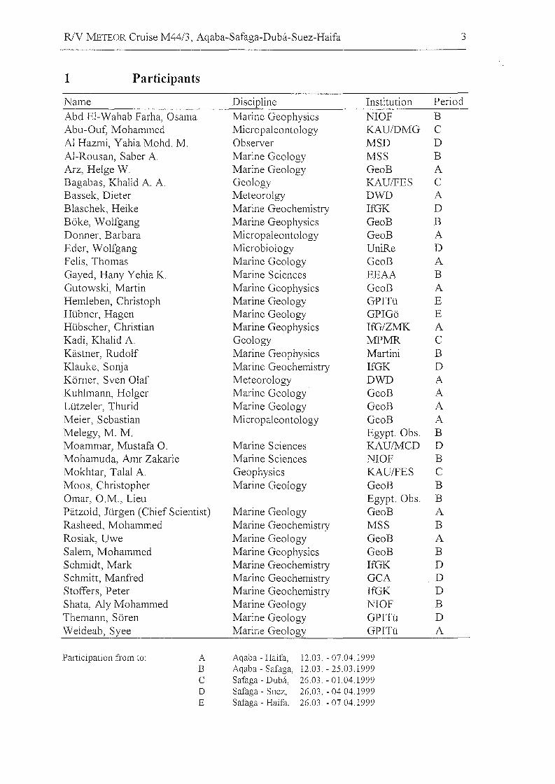
1 Participants
Name Discipline Institution Period
Abd EI-Wahab Farha, Osama Marine Geophysics NIOF BAbu-Ouf, Mohammed Micropaleontology KAU/DMG CAl Hazmi, Yahia Mohd. M. Observer MSD DAl-Rousan, Saber A. Marine Geology MSS BArz, Helge W. Marine Geology GeoB ABagabas, Khalid A. A. Geology KAUlFES CBassek, Dieter Meteorolgy DWD ABlaschek, Heike Marine Geochemistry IfGK DBöke, Wolfgang Marine Geophysics GeoB BDonner, Barbara Micropaleontology GeoB AEder, Wolfgang Microbiology UniRe DFelis, Thomas Marine Geology GeoB AGayed, Hany Yehia K. Marine Sciences EEAA BGutowski, Martin Marine Geophysics GeoB AHemleben, Christoph Marine Geology GPITü EHübner, Hagen Marine Geology GPIGö EHübscher, Christian Marine Geophysics IfG/ZMK AKadi, Khalid A. Geology MPMR CKästner, Rudolf Marine Geophysics Martini BKlauke, Sonja Marine Geochemistry IfGK DKörner, Sven Olaf Meteorology DWD AKuhlmann, Holger Marine Geology GeoB ALützeler, Thurid Marine Geology GeoB AMeier, Sebastian Micropaleontology GeoB AMelegy, M. M. Egypt. Obs. BMoammar, Mustafa O. Marine Sciences KAU/MCD DMohamuda, Amr Zakarie Marine Sciences NIOF BMokhtar, Talal A. Geophysics KAUlFES CMoos, Christopher Marine Geology GeoB BOmar, O.M., Lieu Egypt. Obs. BPätzold, Jürgen (Chief Scientist) Marine Geology GeoB ARasheed, Mohammed Marine Geochemistry MSS BRosiak, Uwe Marine Geology GeoB ASalem, Mohammed Marine Geophysics GeoB BSchmidt, Mark Marine Geochemistry IfGK DSchmitt, Manfred Marine Geochemistry GCA DStoffers, Peter Marine Geochemistry IfGK DShata, Aly Mohammed Marine Geology NIOF BThemann, Sören Marine Geology GPITü DWeideab, Syee Marine Geology GPITü A
Participation from to: A Aqaba - Haifa, 12.03. - 07.04.1999B Aqaba - Safaga, 12.03. - 25.03.1999C Safaga - Duba, 26.03. - 01.04.1999D Safaga - Suez, 26.03. - 04.04.1999E Safaga - Haifa, 26.03. - 07.04.1999
R/V METEOR Cruise M44/3, Aqaba-Safaga-Duba-Suez-Haifa 4
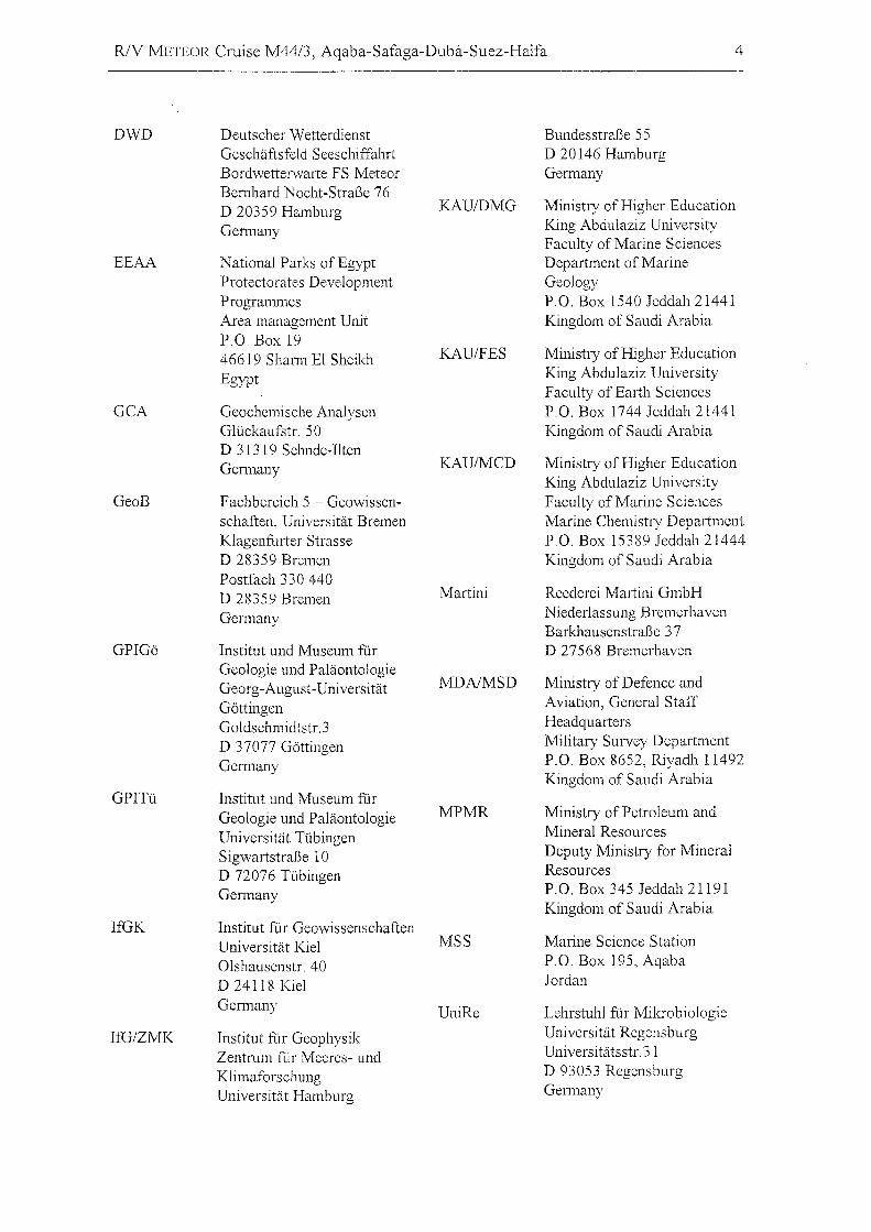
DWD Deutscher Wetterdienst Bundesstraße 55Geschäftsfeld Seeschiffahrt D 20146 HamburgBordwetterwmte FS Meteor GermanyBemhard Nocht-Straße 76D 20359 Hamburg KAU/DMG Ministry of Higher Education
Germany King Abdulaziz UniversityFaculty of Marine Sciences
EEAA National Parks ofEgypt Department of MarineProtectorates Development GeologyProgrammes P.O. Box 1540 Jeddah 21441Area management Unit Kingdom of Saudi ArabiaP.O. Box 1946619 Shann EI Sheikh KAU/FES Ministry ofHigher Education
Egypt King Abdulaziz UniversityFaculty of Earth Sciences
GCA Geochemische Analysen P.O. Box 1744 Jeddah 21441GlÜckaufstr. 50 Kingdom of Saudi ArabiaD 31319 Sehnde-IltenGermany KAU/MCD Ministry ofHigher Education
King Abdulaziz UniversityGeoB Fachbereich 5 - Geowissen- Faculty ofMarine Sciences
schaften, Universität Bremen Marine Chemistry DepartmentKlagenfurter Strasse P.O. Box 15389 Jeddah 21444D 28359 Bremen Kingdom of Saudi ArabiaPostfach 330 440D 28359 Bremen Martini Reederei Martini GmbH
Germany Niederlassung BremerhavenBarkhausenstraße 37
GPIGö Institut und Museum für D 27568 BremerhavenGeologie und Paläontologie
MDAIMSD Ministry of Defence andGeorg-August-UniversitätGöttingen Aviation, General Staff
Goldschmidtstr.3 Headquarters
D 37077 Göttingen Military Survey Department
Germany P.O. Box 8652, Riyadh 11492Kingdom of Saudi Arabia
GPITü Institut und Museum fürGeologie und Paläontologie MPMR Ministry of Petroleum and
Universität Tübingen Mineral Resources
Sigwartstraße 10 Deputy Ministry for Mineral
D 72076 Tübingen Resources
Gennany P.O. Box 345 Jeddah 21191Kingdom of Saudi Arabia
IfGK Institut für GeowissenschaftenUniversität Kiel MSS Marine Science Station
Olshausenstr. 40 P.O. Box 195, Aqaba
D 24118 Kiel Jordan
Germany UniRe Lehrstuhl für Mikrobiologie
IfG/ZMK Institut für Geophysik Universität Regensburg
Zentrum für Meeres- und Universitätsstr.3l
Klimaforschung D 93053 Regensburg
Universität Hamburg Germany
R/V IvlETEOR Cruise M44/3, Aqaba-Safaga-Duba-Suez-Haifa 5
2 Research Program
Geoscientific studies were scheduled during the cruise in the northern Red Sea, the Gulf
of Aqaba, the Gulf of Suez, and in the eastern Mediterranean. The goals of the
paleoceanographic studies in the Gulf of Aqaba were to reconstruct the c1imate history,
the circulation, and water-mass exchange during the late Quaternary. The impact of sea
level changes, variations in productivity, changes in the carbonate budget, and
terrigeneous input should be considered. The geophysical programme aimed to carry out
continuous seismic and hydroacoustic profiling of the sea floor. Evaluation and
interpretation will give detailed descriptions of the development of the tectonic and
sedimentological history within the Gulf of Aqaba. In order to determine the geochemical
budget of the brines in the northern Red Sea it was planned to sampIe the Shaban Deep
and Oceanographer Deep in the central northern Red Sea for geochemical investigations.
High-resolution sampling from the water-columnlbrine interface with the sediment was
also planned. The geochemical project intended to measure hydrocarbon concentrations
and their isotopic composition in order to determine the processes controlling the
formation and oxidation of hydrocarbons in the Red Sea. Elemental exchange rates
between the brines and the water column were analysed and the elemental and isotopic
compositions will be used to assign the origin of the geochemical budget. Also,
paleoc1imatic and paleoceanographic surveys in the northern Red Sea, the Gulf of Suez
as well as in the eastern Mediterranean should be compared. These studies were directed
toward the reconstruction of deep-water formation and productivity and their changes
through time in the two distinct marine environments. An extensive collection of
sediment cores was planned for this expedition to construct a geoscientific section from
the Indian Ocean, continuing through the entire Red Sea, to its northernmost end, and
linking the eastern Mediterranean. A comprehensive data set will be compiled to
reconstruct the environmental changes during the late Quaternary and to determine
c1imatic teleconnections between the oceans.
Marine Geology in the Gulf of Aqaba and the northern Red Sea
The aim of the marine geological and paleoceanographic programme was to reconstruct
the late Quaternary climate history of the northern Red Sea and the Gulf of Aqaba. This
R/V l'vlETEOR Cruise M44/3, Aqaba-Safaga-Duba-Suez-Haifa 6
manne environment suffered extreme oceanographic changes due to its restricted
location. The late Quaternary oceanographic changes will be reconstructed from
sediment cores and will be compared to the history of sea level changes and tectonic
development.
Salinity in the Red Sea is influenced by the exchange of water masses with the Indian
Ocean and is driven by sea level changes. Amplified climatic signals are recorded in the
Red Sea. Stable oxygen isotope chronologies reveal enhanced signals compared to the
global isotopic record. Focus was given to different periods of climatic change. High
resolution studies will be performed to reveal the deglacial history and the Holocene
record. The terrestrial c1imate history from northeast Africa and the Middle East is weil
documented. Wet periods are known from the early Holocene. A comparison between
marine and terrestrial records will give clues to the climatic interactions between land and
ocean.
A second focus of interest was the reconstruction of environmental conditions during the
last glacial maximum. Prior to this climatically extreme event many planktic and benthic
organisms lost their habitat due to alethal salinity increase. Later, during deglaciation,
marine conditions became more favorable again during sea level rise. The succession of
marine organisms during this extreme period will be analysed. The fate of reef organisms
during this period is unknown.
A third primary focus was the high-resolution reconstruction of isotopic stage 3. Rapid
c1imatic change is weil known from ice cores and marine sediment records from various
oceans. The present studies aim to analyse this period in the northern Red Sea. Lake
sediments from the precursor of the modern Dead Sea display sedimentary chronologies
for comparison. The development of the Lisan Formation dates back to between 20,000
to 70,000 years before present and represents a terrestrial analogue to marine isotopic
stage 3. It is of international interest to study and understand the processes of climate
variability during this period.
Changes in circulation have a great impact on the material budget and productivity ofthe
northern Red Sea and Gulf of Aqaba. The variable production of carbonate and organic
material will be studied during glacial and interglacial times. The paleoceanographic
results will be used for a synoptic analysis, which will describe the exchange processes
between the Indian Ocean and the Red Sea and the impact on the Gulf of Aqaba. A
R/V :NlETEOR Cruise M44/3, Aqaba-Safaga-Duba-Suez-Haifa 7
comparison with oceanographic changes in the Mediterranean will also help to clarify the
impact ofthe monsoon system during the laie Quaternary.
The geological studies incIuded sampling of the water column, the surface sediments and
the sediment column. It was plam1ed to sampie the Gulf of Aqaba on various profiles
along the main axis and across the sediment basin. In addition, different surveys and
sampling were intended in selected areas in the northern Red Sea. Each profile was
selected to provide a set of stations in different water depths. At each station a similar
sampling procedure was carried out. The water column was sampled by plankton tows
for planktic organisms. Water sampies were analysed from depth profiles for stable
oxygen and carbon isotopic composition for comparison to the profiles of temperature,
salinity and oxygen content.
Sampies of surface sediments by grab sampier, box corer and multi-corer were used to
map the recent sedimentation on the sea floar, and for revealing undisturbed surface
layers. Surface sediments document the modern sedimentation and are important
references for paleoceanographic reconstructions. Sediment cores up to 18 m in length
were recovered. Most of them were opened, documented, described, and sampled. A
comprehensive sampling procedure was carried out on the cores for later detailed
analyses (biostratigraphy, stable isotope stratigraphy, physical properties, biology and
micropaleontology, sedimentology, isotope geology, and geochemistry). A preliminary
stratigraphy was established by the abundance of planktic foraminifera and color
variations in the sediment cares.
Geophysical investigations in the Gulf of Agaba and the northern Red Sea
The geophysical program included profiling seismic and hydro-acoustic measurements.
The goal was the 2-dimensional imaging of the sea floar and its sedimentary cover.
Measurement of bathymetry with the swath sounder HYDROSWEEP and imaging of the
uppermost sediments with the narrow beam echosounder PARASOUND were carried out
continuously throughout the cruise, while multi-channel seismics were planned just for
certain areas. Data analysis and interpretation should provide a detailed characterization
of the tectonic and sedimentary history of the survey areas.
Detailed studies were mainly planned for the Gulf of Aqaba: internal structures, sea floor
topography, and budget calculations of the large subaqueous sedimentary fans in front of
RlV METEOR Cruise M44/3, Aqaba-Safaga-Duba-Suez-Haifa 8
the wadis Watir, Dahab, and Kid. The sediment input results from rare rainfall on the
Sinai Peninsula. The growing pattern reflects the impact of sea level and climatic
fluctuations on sediment input and depositional processes. Problems of the
reconstruction of the tectonic history will be tackled in the very north at the crossing of
the Shlomo Graben and the Elat Fault. Another important target was the Aragonese
Deep, a proposed pull-apart basin.
In the northern Red Sea, the focus was given to fluid migration and exchange between
young oceanic crust and seawater column through the sedimentary cover. Fluid
migration paths have been recently observed in high-resolution seismic data in the east
Pacific. The closest link between geology and geophysics will result from an integrated
interpretation of sediment cores and ultra-high resolution seismo-acoustic data, since
these data provide information about the structural context of each core.
Exchange processes at brine-seawater interfaces in Red Sea deeps
One goal ofthe ongoing research in the Red Sea was to characterize genetic processes of
trace gases in the sediments, water columns and brines of Red Sea deeps. Isotopic
compositions of hydrocarbon gases, in particular, should give us better information about
thermal degradation processes of buried organic compounds in deeper sediments.
Furthermore, bacterial methanogenesis or oxidation should be characterized by isotopic
measurements.
The main objective during this crulse was to understand the complex mixing and
oxidation processes of hydrocarbons in the brine-seawater interface. Furthermore, high
resolution sampling « 1In, without disturbance of the layered water structure) and
isotope measurements of various trace gases were performed. Microbial investigations
will uncover hydrocarbon formation and/or oxidation processes by microorganisms.
Inorganic chemistry investigations (e.g. elemental cOlnposition and isotope ratios of trace
elements) of brine layers will provide information about fluid sources. Detailed
investigations of concentration gradients at brine-seawater interfaces will provide better
understanding of exchange processes and complex redox cycles.
Hydrographic data of the water column in Shaban and Oceanographer Deep in the
northern Red Sea were measured by CTD. Brine-seawater interfaces were identified by
temperature and salinity increases. These interfaces were sampled by a newly designed
R/V METEOR Cruise M44/3, Aqaba-Safaga-Duba-Suez-Haifa 9
interface-sampler. With this special device we were able to take undiluted water sampies
from biogeochemically active water layers with a high resolution. Water sampies were
planned to be degassed and onboard gaschromatographie analyses should give
information about the gaseous compositions. Isotope ratios of hydrocarbons will be
measured after the cruise at BGR (Hannover).
It was planned to sampie the steep gradients of inorganic trace elements at the brine
seawater interface with a special interface sampier (IS-l, DeLange), if possible. This
device fills 10 syringes (50mi) simultaneously at the selected water depth over a 3m
interval. Water sampies will be measured onboard under anoxie conditions. Brine bodies
and Red Sea deep waters will be sampled using a Hydrobios water sampier (51 Niskin
bottles, CTD-device). Oxygen, alkalinity and pH will be measured onboard. It was
planned to perform cation- and anion-measurements at Kiel University.
Far microbial investigations (University Regensburg) water sampies were taken from the
same water depth of geochemical interest. The influence of microbial activity on
inorganic/arganic redox processes should be characterized by the abundance of specific
organisms, which will be se1ected and cultivated in the land laboratory. This combined
microbial and geochemical research will give us new information about microbial
activities under extreme environmental conditions and the geochemical characteristics of
related trace gases and elements (only known by empirical assumptions).
Reconstruction of the Pleistocene and Holocene paleoenvironment in the Levantine Sea
and the Gulf of Suez by means ofbenthic and planktic forarninifera
The main objective of this study is to reconstruct the history of intermediate- and deep
water circulation and paleoproductivity in the Levantine Sea, the northern Red Sea and
the Gulf of Suez during the late Pleistocene. Previous paleoceanographic studies have
shown that past climatic changes are clearly recorded in sediments from the eastern
Mediterranean and the Red Sea. These climatic fluctuations can be reconstructed from
the species composition and stable isotope signals of both planktic and benthic
foraminifera. However, the significance of the individual environmental parameters
(salinity, temperature, productivity, deep water circulation) and their connection to the
regional and global climate is still controversial. To solve these questions, high-resolution
studies are required to record short-term paleoc1imatic events, and more information is
RJV I\!1ETEOR Cruise M4413, Aqaba-Safaga-Duba-Suez-Haifa 10
necessary to document the present manne environment and circulation patterns for
comparison to the past. Finally, we want to characterize the impact of Quaternary
c1imatic changes on both oceanic environments that are divided in terms of oceanography
and biogeography.
During the cruise it was planned to sampIe surface sediment and sediment cores at
different stations by means of a multicorer and a piston corer. Prior to coring the site
would be intensively investigated using PARASOUND and HYDROSWEEP to find the best
spot to care. The recovered sediment sampIes will be investigated for temporal and
spatial changes in the compositions of planktic and benthic foraminiferal faunas and the
stable oxygen and carbon isotope signals of their tests. Since we will mainly concentrate
on high-resolution studies we expect to gain information not only on long-term glacial to
interglacial cycles but also on high frequency fluctuations of the past climate and deep
water circulation. The surface sediment sampIes will be studied to describe the ecology
of the faunal assemblages and the relationship between the stable isotope signal and
various environmental parameters. These results will serve as a modern analogue for the
reconstruction of the paleoceanographic history of the different regions. This new data
set will close the gap between our existing results from the Mediterranean Sea, Red Sea,
and Gulf of Aden.
R/V METEOR Cruise M44/3, Aqaba-Safaga-Duba-Suez-Haifa 11
3 Summarized Cruise Report
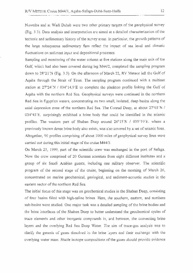
After three days in port, R/V METEOR left Aqaba on the morning of Friday, March 12,
1999, beginning the third leg of Cruise M44. During the first part of the cruise, from
Aqaba to Safaga, the scientific program inc1uded marine geo10gical and geophysical
studies primarily in the Gulf of Aqaba, but also in the northern Red Sea, in Jordanian,
Israeli, and Egyptian waters (Fig. 3.1). The new scientific shipboard party inc1uded 14
colleagues from German institutes. The group of guest scientists on board from countries
neighboring the Red Sea consisted of two young colleagues from Jordan and seven
participants from Egypt, inc1uding two naval observers.
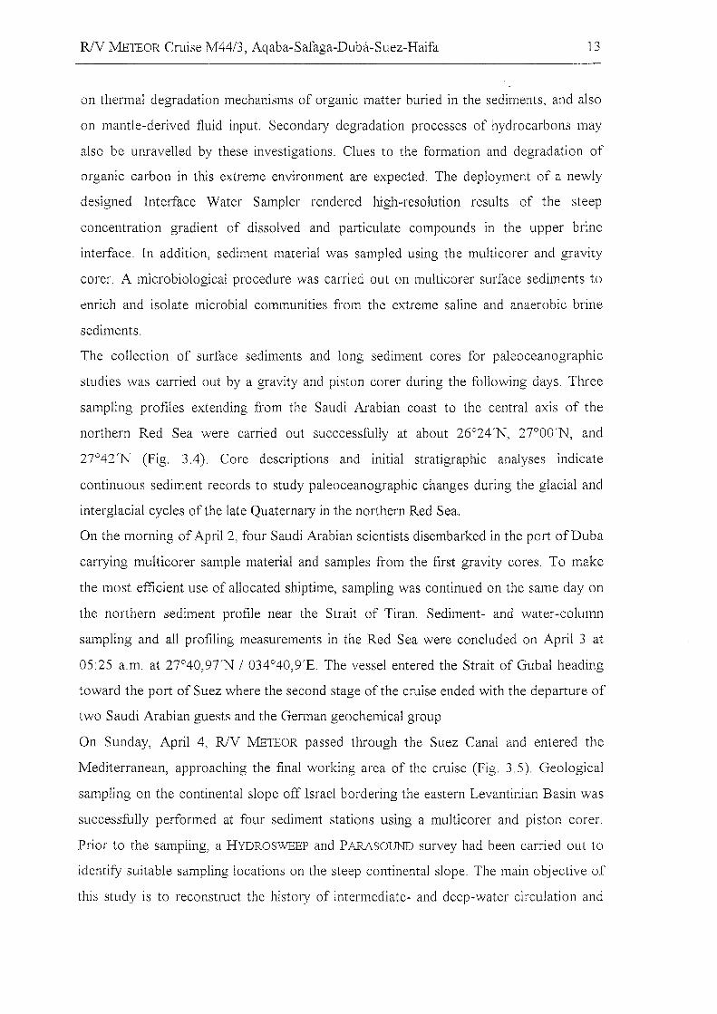
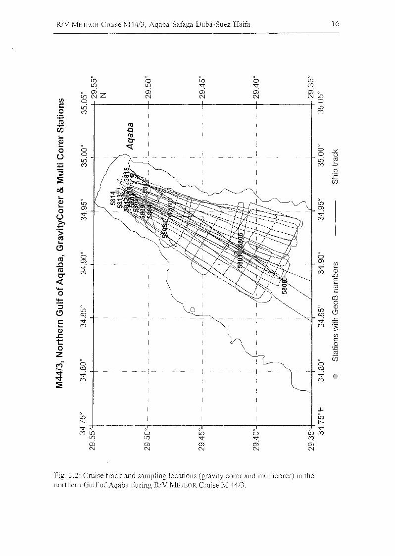
Extensive hydro-acoustic studies were carried out initially in the northernmost Gulf of
Aqaba, within the territorial waters of Jordan and Israel, by HYDROSWEEP and
PARASOUND. Geological sampling of the sea floor by multicorer, box corer, and gravity
corer provided a set of sediment cores in water depths ranging from 135 to 838 m (Fig.
3.2). The northern Eilat Deep was also successfully samp1ed by sediment cores. The
cores reveal records with high temporal resolution from the latest Quaternary,
characterized by high silicic1astic input and multiple sets of turbidites. The shallower
cores contain greater abundances of pteropods and both benthic and planktonic
foraminifera. On the evening of March 16, the geological sampling of sediments was
completed in this area with a box corer directly in front of Aqaba harbour. All the
sediment cores from this survey area were opened and documented, and some were also
sampled on board at high resolution for further studies in the home institutes. The
comprehensive sampling program during the early days of the cruise also inc1uded the
collection of plankton and water sampies from the water column using multinets and the
pumping of surface waters, respectively, as weIl as the monitoring of oceanographic
conditions with CTD profiles.
Multi-channel seismic surveys in the Gulf of Aqaba were initiated on the evening of April
13 in Jordanian and Israeli waters, and were continued later in Egyptian waters. The first
area of interest was the northern end of the Gulf of Aqaba. Problems relating to the
reconstruction of tectonic history were tackled in the southwestern Eilat Deep near Ras
Burka, to improve the understanding of structures at the crossing of the Shlomo Graben
with the Eilat Fault. The submarine fans of the wadi deposits from Wadi Watir off
R/V METEOR Cruise M44/3, Aqaba-Safaga-Duba-Suez-Haifa 12
Nuweiba and at Wadi Dahab were two other primary targets of the geophysical survey
(Fig. 33). Data analysis and interpretation are aimed at a detailed characterization ofthe
tectonic and sedimentary history of the survey areas. In particular, the growth patterns of
the large subaqueous sedimentary fans reflect the impact of sea level and climatic
fluctuations on sediment input and depositional processes.
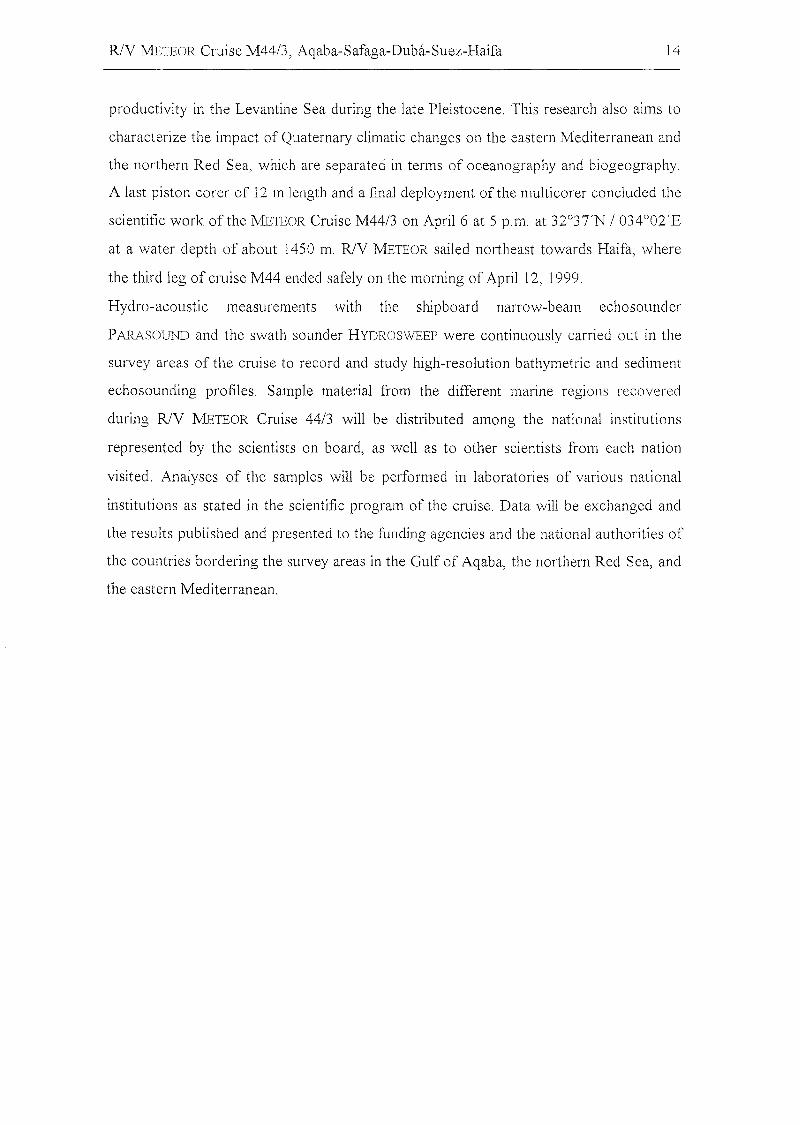
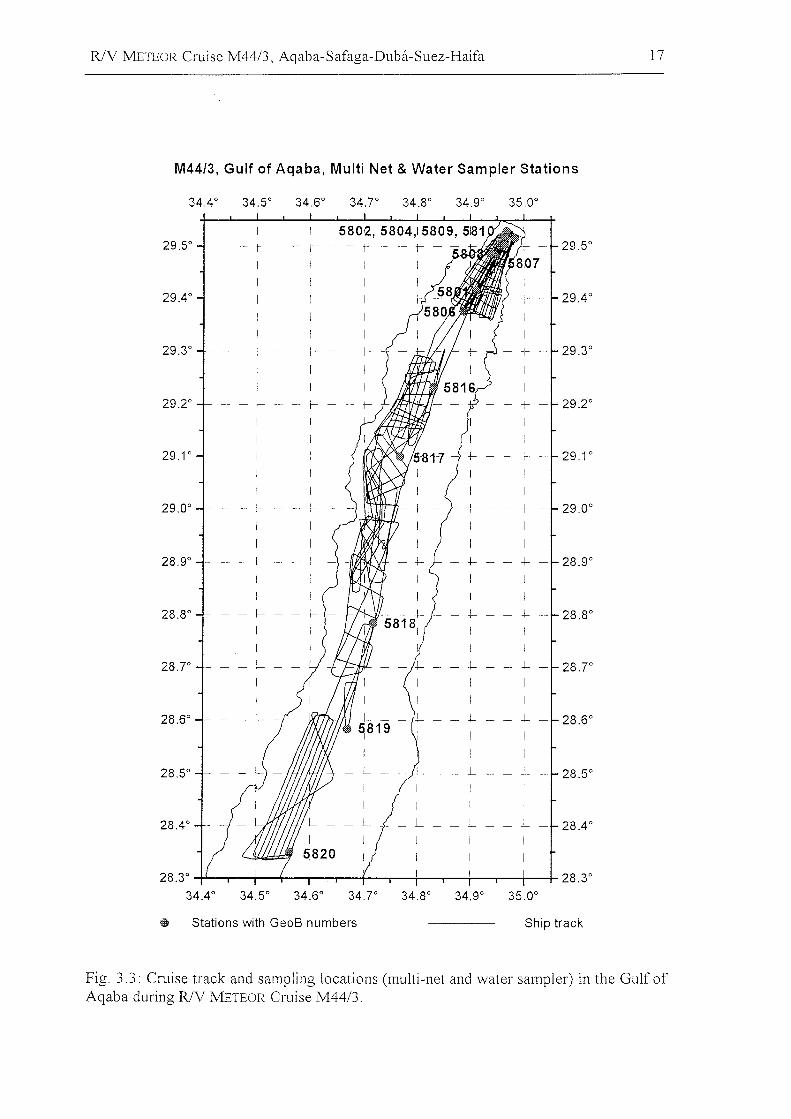
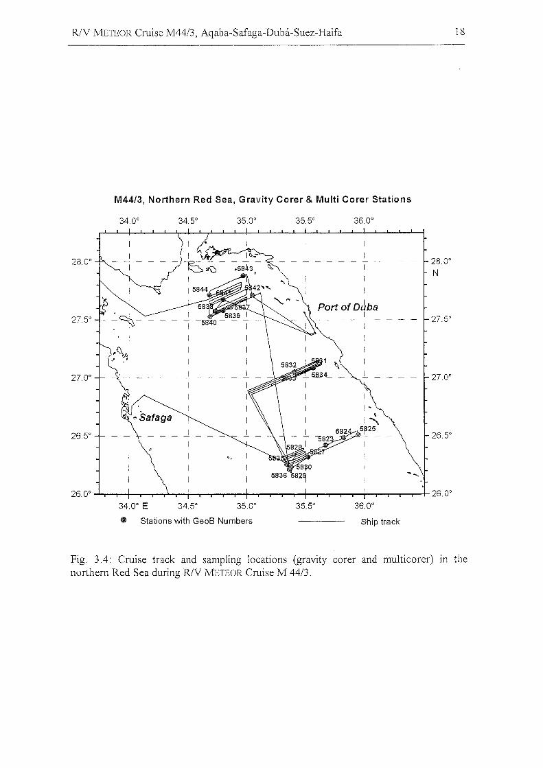
Sampling and monitoring of the water column at five stations along the main axis of the
Gulf, which had also been covered during leg M44/2, completed the sampling program
down to 28°21'N (Fig. 3.3). On the afternoon ofMarch 22, RV Meteor left the Gulfof
Aqaba through the Strait of Tiran. The sampling program continued with a multinet
station at 27°24'N / 034°14,9'E to complete the plankton profile linking the Gulf of
Aqaba with the northern Red Sea. Geophysical surveys were continued in the northern
Red Sea in Egyptian waters, concentrating on two small, isolated, deep basins along the
axial depression zone of the northern Red Sea. The Conrad Deep, at about 27°03 'N /
034°43 'E, surprisingly exhibited a brine body that could be identified in the seismic
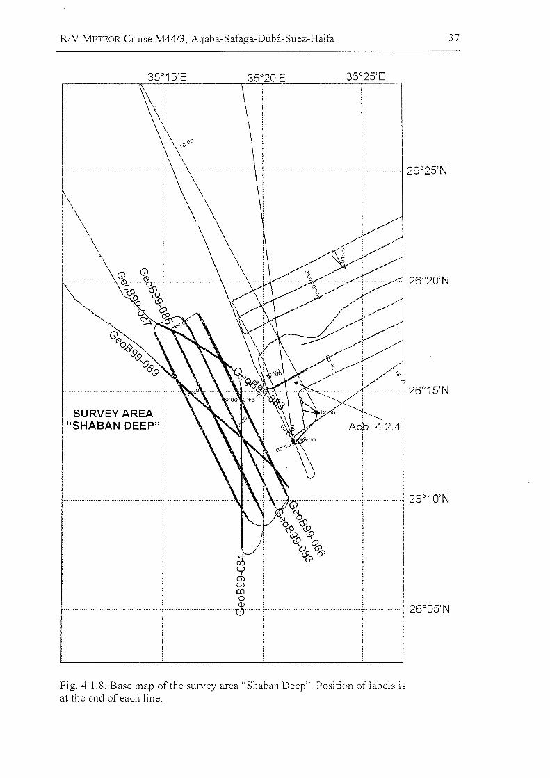
profiles. The western part of Shaban Deep around 26°15'N / 035°19'E, where a
previously known dense brine body also exists, was also covered by a set of seismic lines.
Altogether, 90 profiles comprising of about 1000 miles of geophysical survey lines were
carried out during this initial stage of the cruise M44/3.
On March 25, 1999, part of the scientific crew was exchanged in the port of Safaga.
Now the crew comprised of 20 German scientists from eight different institutes and a
group of six Saudi Arabian guests, inc1uding one military observer. The scientific
program of the second stage of the cruise, beginning on the morning of March 26,
concentrated on marine geochemical, geologieal, and sediment-aeoustic studies in the
eastern seetor ofthe northern Red Sea.
The initial focus of this stage was on geochemieal studies in the Shaban Deep, eonsisting
of four basins filled with high-saline brines. Here, the southern, eastern, and northern
sub-basins were studied. One major task was a detailed sampling of the brine bodies and
the brine interfaces of the Shaban Deep to better understand the geochemical cycles of
traee elements and other inorganie eompounds in, and between, the eonvecting brine
layers and the overlying Red Sea Deep Water. The aim of trace-gas analysis was to
c1arify the genesis of gases dissolved in the brine layers and their exchange with the
overlying water mass. Stable isotope cOlnpositions of the gases should provide evidence
R/V JVlETEOR Cruise M44/3, Aqaba-Safaga-Duba-Suez-Haifa 13
on thermal degradation mechanisms of organic matter buried in the sediments, and also
on mantle-derived fluid input. Secondary degradation processes of hydrocarbons may
also be unravelled by these investigations. Clues to the formation and degradation of
organic carbon in this extreme environment are expected. The deployment of a newly
designed Interface Water SampIer rendered high-resolution results of the steep
concentration gradient of dissolved and particulate compounds in the upper brine
interface. In addition, sediment material was sampled using the multicorer and gravity
corer. A microbiological procedure was carried out on multicarer surface sediments to
enrich and isolate microbial communities from the extreme saline and anaerobic brine
sediments.
The collection of surface sediments and long sediment cores for paleoceanographic
studies was carried out by a gravity and piston carer during the following days. Three
sampling profiles extending from the Saudi Arabian coast to the central axis of the
northern Red Sea were carried out succcessfully at about 26°24'N, 27°00'N, and
27°42 'N (Fig. 3.4). Core descriptions and initial stratigraphic analyses indicate
continuous sediment records to study paleoceanographic changes during the glacial and
interglacial cycles of the late Quaternary in the northern Red Sea.
On the morning of April 2, four Saudi Arabian scientists disembarked in the port ofDuba
carrying multicorer sampie material and sampies from the first gravity cores. To make
the most efficient use of allocated shiptime, sampling was continued on the same day on
the northern sediment profile near the Strait of Tiran. Sediment- and water-column
sampling and all profiling measurements in the Red Sea were concluded on April 3 at
05:25 a.m. at 27°40,9TN / 034°40,9'E. The vessel entered the Strait of Gubal heading
toward the port of Suez where the second stage ofthe cruise ended with the departure of
two Saudi Arabian guests and the German geochemical group.
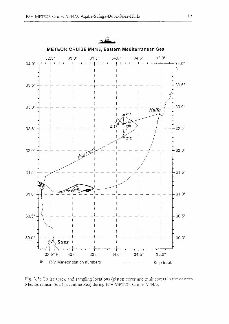
On Sunday, April 4, R/V METEOR passed through the Suez Canal and entered the
Mediterranean, approaching the final working area of the cruise (Fig. 3.5). Geological
sampling on the continental slope off Israel bordering the eastern Levantinian Basin was
successfully performed at four sediment stations using a multicorer and piston carer.
Prior to the sampling, a HYDROSWEEP and PARASOUND survey had been carried out to
identify suitable sampling locations on the steep continental slope. The main objective of
this study is to reconstruct the history of intermediate- and deep-water circulation and
RlV WlETEOR Cruise M44/3, Aqaba-Safaga-Duba-Suez-Haifa 14
productivity in the Levantine Sea during the late Pleistocene. This research also aims to
characterize the impact of Quaternary climatic changes on the eastern Mediterranean and
the northern Red Sea, which are separated in terms of oceanography and biogeography.
A last piston corer of 12 m length and a final dep10yment of the multicorer concluded the
scientific work ofthe METEOR Cruise M44/3 on April 6 at 5 p.m. at 32°3TN 1034°02'E
at a water depth of about 1450 m. RlV METEOR sailed northeast towards Haifa, where
the third leg of cruise M44 ended safelyon the morning of April 12, 1999.
Hydro-acoustic measurements with the shipboard narrO\,v-beam echosounder
PARASOUND and the swath sounder HYDROSWEEP were continuously carried out in the
survey areas of the cruise to record and study high-resolution bathymetric and sediment
echosounding profiles. Sampie material from the different marine regions recovered
during RlV METEOR Cruise 44/3 will be distributed among the national institutions
represented by the scientists on board, as well as to other scientists from each nation
visited. Analyses of the sampies will be performed in laboratories of various national
institutions as stated in the scientific program of the cruise. Data will be exchanged ancl
the resll1ts published and presented to the funding agencies and the national authorities of
the countries bordering the survey areas in the Gulf of Aqaba, the northern Red Sea, and
the eastern Mediterranean.
R/V METEOR Cruise M44/3, Aqaba-Safaga-Duba-Suez-Haifa 15
oogz
oL{)
0)N
oo0)N
oL{)
roN
ooroN
oL{)
f'N
oof'N
oL{)
CDN
ooCDN
ool{)C'0
ol{)
(V)(V)
ol{)
.qC'0
oo.q(V)
o
~C'0C'0
o
~l{)C'0
ol{)
L{)
C'0
ooCDC'0
'~
I Wo
~- - - .qC'0
I
I
I
I
T
-l
I
J
I
I
ooL{)C'0
oL{)
L{)(V)
oL{)
.q - - (V)
ooCD(V)
oo(V)(V)
ol{)
C'0C'0
oo.qC'0
oL{)
N(V)
-
M-"""""":EwCI)
=>~U~oWIW:E
oWz(J)N
o.q0)N
oN(J)N
oo0)N
ororoN
oW00N
o'<:tcON
oN00N
Fig. 3.1: Cruise track in the Gulf of Aqaba (left and right panel) and the northern RedSea (right panel) during R/V METEOR Cruise M 44/3.
R/V METEOR Cruise M44/3, Aqaba-Safaga-Duba-Suez-Haifa 16
0 0 0 0 0L{) 0 L{) 0 L{)L{) L{) '<:t '<:t C'0
0 ~Z(J) (J) (J) (J) 0
L{) N N N N L{)tJ) 0 0c:: L{) LD0 C'0 C'0
+:i«I CO..-
CI) ..Q5- CO<I> e-5- 0 q; 0
0 0 0 ..;;,;:;
U 0 0 üL{) L{) cu
'-.- C'0 C'0 ~:= 0-:;j
:E .r::Cf)
~5-<I> 0 0
L{) L{)5- (J) (J)0
U '<:t '<:tC'0 C'0
~..->«I5-
~0 0
«I 0 0
..0(J) (J)
(f)
"<:t "<:t '-«I C'0 C'0 <D0" .0
« E"t- ::J
0 C
"t- ro0
:;j 00
0 <D~
L{) L{) (9co I 00- - - - - - - - - - - - - - - -~ .r::c:: '<:t I I "<:t ......5- C'0 C'0 .~<I> I
~:..s:: (f)
..- I c5- 00
I"Z
Z cu
--~~
~0 I 0 Cf)
M 0 0- 00 -l- I 00"ld' - - - - - - - --r - -
'<:t "<:t @"ld' C'0 I C'0~
I -
I
I W0 0L{) I L{)I'- I'-'<:t 0 0 0 0 0 '<:tC'0 L{) 0 L{) 0 L{) C'0
L{) L{) ~ '<:t C'0(J) (J) (J) (J) (J)N N N N N
Fig. 3.2 Cruise track and sampling locations (gravity corer and multicorer) in thenOl1hern Gulf of Aqaba during R/V IvlETEOR Cruise M 44/3.
R/V METEOR Cruise M44/3, Aqaba-Safaga-Duba-Suez-Haifa 17
M44/3, Gulf of Aqaba, Multi Net & Water Sam pier Stations
34.4° 34.so 34.6° 34.r 34.8° 34.9° 35.0°
29.4°
29.5°
-l- - 29.1°
I
+- - 29.0°
I
I
+- - 28.9°I
I
J- - 28.8°
I
-I- - 28.rI
I
-I- - 28.6°I
+- - 29.2°
+- - 29.3°
1- - 28.4°
1- - 28,SO
35.0°
+I
I
I
L
I
I
L
I
I
+5818
1
I
-II
I
L
1
34.r 34.8° 34.9°
f-
I
I
r-
I
rI
f-
I
rI
I
II
I
rI
I
rI
I
34,SO 34.6°
29.5°
29.4°
29.2°
29.3°
29.1 °
29.0°
28.r
28.9°
28.8°
28.6°
28.so
28.4°
IL
II
L
I
I
28.3° -t-'----,;---+--I---+-....--+-..,.---t-...,----il;----r--+-_+_ 28.3°
34.4°
@ Stations with GeoB numbers Ship track
Fig. 3.3: Cruise track and sampling locations (multi-net and water sampier) in the Gulf ofAqaba during R/V METEOR Cruise M4413.
R/V METEOR Cruise M44/3, Aqaba-Safaga-Duba-Suez-Haifa 18
M44/3, Northern Red Sea, Gravity Corer & Multi Corer Stations
34.0° 34.5° 35.0° 35S 36.0°
27.5"
28.0°
N
Port of OJbaI
28.0°
27.5"
27.0° - ~ ~ - - - - - - - - - 27.0°
II ~
",Safaga \I,26.5° ~ ~
5Jl25_- 26SO
I 1
I '. I
1 I
I'~.
1
26.0° 26.0°
34.0° E 34SO 35.0° 35SO 36.0°
@ Stations with GeoB Numbers Ship track
Fig. 3.4: Cruise track and sampling locations (gravity corer and multicorer) In thenorthern Red Sea during R/V METEOR Cruise M 44/3.
RlV JvlETEOR Cruise M44/3, Aqaba-Safaga-Duba-Suez-Haifa 19
J.~
METEOR CRUISE M44/3, Eastern Mediterranean Sea
32.5° 33.0° 33.5° 34.0° 34.5° 35.0°
34.0° 34.0°
I N
I
I33.5° I
- - - - - - - -I
- -I
- -i - - 33.5°I
I I I
I I I
I I I33.0° - - - - - 33.0°
I I
I I
I
I32.5° - - - 32.5°
I
I
I I
I - - et§\ I32.0°32.0° - - - - -
I . tY I IhJ JI S I I
I I I
31.5°I i I I
31.5°- - - - - - - - -
i I I I
I I
I I
31.0° I I I 31.0°- - - - - - -
I I I I I
I I i I
I I I I
30.5° - I- I - I - - I - - I - - 30.5°I I I I
I I I I I
I I I I I
30.0° - - - I- - I- - I - - I - - 30.0°Suez I I I I
I I
32.5° E 33.0° 33.5° 34.0° 34.5° 35.0°
@ RN Meteor station numbers Ship track
Fig. 3.5: Cruise track and sampling locations (piston corer and multicorer) in the easternMediterranean Sea (Levantine Sea) during RlV METEOR Cruise Ivl44/3.
RlV METEOR Cruise M44/3, Aqaba-Safaga-Duba-Suez-Haifa
4 Preliminary Results
4.1 Very High-Resolution Multichannel Reflection Seismies
(e. Hübscher, W. Böke, M. Gutowski, R. Kästner, M. Salem)
4.1.1 Introduction
20
Multichannel selsmlC measurements were carried out with the equipment of the
Department of Earth Sciences, Bremen University, utilizing two seismic sources of
different volume in an alternating mode for some profiles. A SODERA Inc. S-15 water
gun with a frequency range from 200 to 2000 Hz provides information on the upper 100
to 300 m ofthe sediment column, whereas a GI-Gun (Generator-Injector Gun; SODERA
Inc.) with signal energy up to 350 Hz allows seismic imaging of sedimentary layers down
to 1500 m below the sea floor. A total of 1680 km of multichannel data were collected
along 89 seismic lines.
4.1.2 Instmments
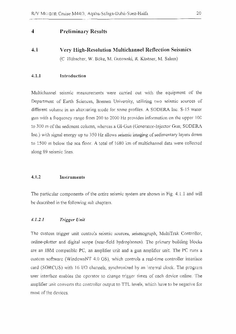
The particular components of the entire seismic system are shown in Fig 4.1.1 and will
be described in the following sub chapters.
4.1.2.1 Trigger Unit
The custom trigger unit controls seismic sources, seismograph, MultiTrak Controller,
online-plotter and digital scope (near-field hydrophones). The primary building blocks
are an IBM compatible PC, an amplifier unit and a gun amplifier unit. The PC runs a
custom software (WindowsNT 4.0 OS), which controls a real-time controller interface
card (SORCUS) with 16 1/0 channels, synchronized by an internal clock. The program
user interface enables the operator to change trigger times of each device online. The
amplifier unit converts the controller output to TTL levels, which have to be negative for
most of the devices.
"1- I
.. .......<llI ....... - ~ lIo
Lead In 50 m Stretch 3 Active Sections a100 m = 300 m
Fig. 4.1.1: Multichannel seismic instrumentation used during RN Meteor M44/3.
ASCIINavigationData
~<:
~~o:;d
nS.Cf)
CD
$:.j:>..j:>.
----vJ
;:J>,-Ci
&po
IC/)po
IPCfQpo
6s::vpo-
IC/)
s::CDN
~po
~
10
R/V METEOR Cruise M44/3, Aqaba-Safaga-Duba-Suez-Haifa 22
The gun amplifier unit was placed in the compressor container to avoid electronic noise
in the seismic lab. It generates the required 60V/8 Amp. trigger level for the magnetic
valves ofthe individual seismic sources.
4.1.2.2 Seismic Sources and Compressor
For the seismic surveying two different seismic sources, a GI-Gun and a watergun, were
available. For some profiles they were triggered in an alternating mode at a time interval
of 13 s between sources. If the GI-Gun was the only source, the time interval between
shots was lOs which results in a shot spacing of 25 m owing to an average ship speed of
4.9 kn over ground. Both sources were operated with an air pressure of 145 bar. Ship
velocity (through water) during deployment and retrieval was 3 kn and 2 kn,
respectively.
Junkers compressors owned by the Alfred-Wegener-Institute of Polar and Marine
Research, Bremerhaven provided high-pressure air for gun operation. The compressors
were operated according to the requirements ofthe chosen gun volumes.
The volume of a standard GI-Gun was reduced to 2 x 0.41 I by two special titanium
volume reducers. It was towed starboard by a wire from the A-crane about 20 m behind
the ship. The towing wire was connected to a bow with the GI-Gun hanging on two
chains. An elongated buoy, which stabilized the gun in a horizontal position in a water
depth of ~1.5 m, was connected above the bow. The Injector was triggered with a delay
of 31 ms with respect to the Generator .signal, which basically eliminated the bubble
signal.
The second source type was a S15 watergun (SODERA) with a volume of 0.16 1. The
watergun was towed by a Meteor rape, that was fixed to the umbilical of the watergun,
about 20 m behind the ship' s stern. A steel frame held the watergun in a tight position
parallel to the elongated buoy in a depth of approximately 0.7 m.
R/V METEOR Cruise M44/3, Aqaba-Safaga-Duba-Suez-Haifa 23
4.1.2.3 Streamer
For operation in the shallow water environment of the Gulf of Aqaba only 300 m of the
600 m long streamer were used. The multichannel seismic streamer (SYNTRON)
consisted of a tow-Iead, one 50 m long stretch section and three active sections of 100 m
length each. A 100 m long Meteor rope with a buoy at the end was connected to the tail
swivel. A 30 m long deck cable connected the streamer to the recording system. During
operations the streamer (tow lead) was fixed with two Meteor ropes. The distance from
the ship's stern to the beginning of the stretch section was 40 !TI.
In order to optimize the frequency response character of the streamer in shallow water
and therefore large reflection angles, hydrophone groups consisting of only 2
hydrophones at a distance of 0.32 m were chosen. 24 of those channels with amidpoint
distance of 12.5 m have been recorded.
Ship's speed during deployment and retrieval was 3 kn and 2 kn, respectively.
Deployment and retrievallasted around 30 minutes including installation ofthe 4 Remote
Bird Units (RUs; see below).
4.1.2.4 jV/ultitrak Bird Controller
In operation 4 MultiTrak Remote Units (RU) were attached to the streamer. The
position ofRUs is listed in Tab. 4.1.1. Each RU includes a depth and a heading sensor as
weil as adjustable wings. The MultiTrak controllers in the seismic lab control the RUs.
Controller and RUs communicate via communication coils nested within the streamer. A
twisted pair wire within the deck cable connects controller and coils. One wire had to be
grounded to avoid communication errors. Each shot trigger started a scan (delay 0.5 s,
duration 0.2 s) to retrieve values for water depth, heading, water temperature, and
battery voltage. The current location ofthe streamer (depth or heading versus offset) can
be displayed on a monitor. All parameters are digitally stored on the controller PC
together with shot number, date, and time.
RlY METEOR Cruise M44/3, Aqaba-Safaga-Duba-Suez-Haifa
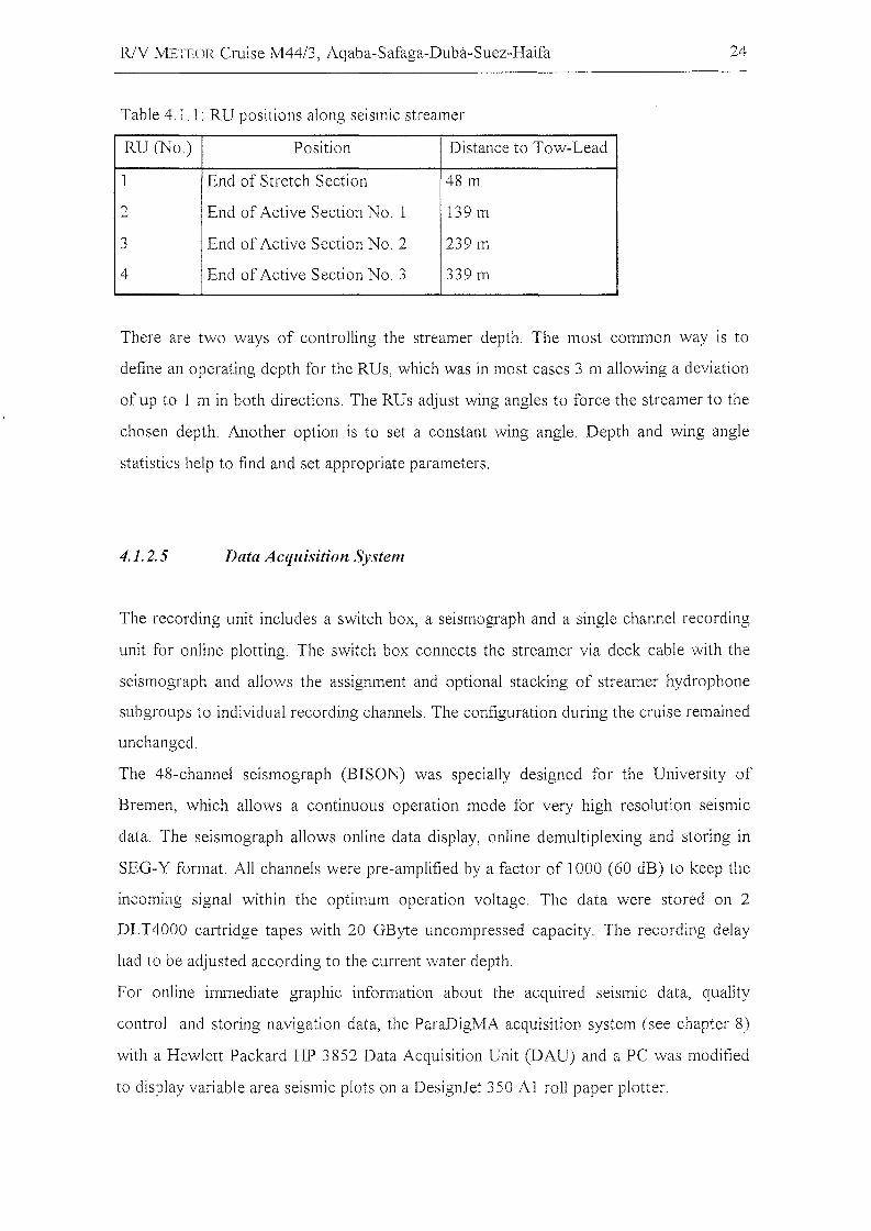
Table 4,1.1: RU positions along seismic streamer
RU(No) Position Distance to Tow-Lead
1 End of Stretch Section 48 m
2 End of Active Section No, 1 139 m
3 End of Active Section No, 2 239 m
4 End of Active Section No, 3 339 m
24
There are two ways of controlling the streamer depth. The most common way is to
define an operating depth for the RUs, which was in most cases 3 m allowing a deviation
of up to 1 m in both directions, The RUs adjust wing angles to force the streamer to the
chosen depth, Another option is to set a constant wing angle. Depth and wing angle
statistics help to find and set appropriate parameters,
4.1.2.5 Data Acquisition System
The recording unit incIudes a switch box, a seismograph and a single channel recording
unit for online plotting. The switch box connects the streamer via deck cable with the
seismograph and allows the assignment and optional stacking of streamer hydrophone
subgroups to individual recording channels, The configuration during the cruise remained
unchanged.
The 48-channel seismograph (BISON) was specially designed for the University of
Bremen, which allows a continuous operation mode for very high resolution seismic
data, The seismograph allows online data display, online demultiplexing and storing in
SEG-Y format. All channels were pre-amplified by a factor of 1000 (60 dB) to keep the
incoming signal within the optimum operation voltage. The data were stored on 2
DLT4000 cartridge tapes with 20 GByte uncompressed capacity. The reeording delay
had to be adjusted according to the current water depth,
For online immediate graphie information about the acquired selsmlC data, quality
control and storing navigation data, the ParaDigMA acquisition system (see chapter 8)
with a Hewlett Packard HP 3852 Data Acquisition Unit (DAU) and a PC was modified
to display variable area seismic plots on a DesignJet 350 Al roll paper plotter,
RlV METEOR Cruise M44/3, Aqaba-Safaga-Duba-Suez-Haifa
4.1.3 Base lVlaps and First Results
25
All seismic lines are listed in Tab. 4.1.2. Figures 4.1.2-4.1.8 show base maps from the
different working areas. Common offset gathers are presented in the subsequent figures
(4.1.9-4.1.15).
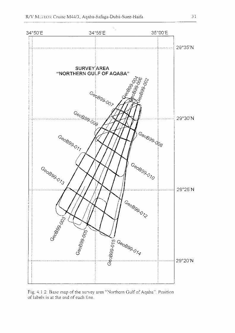
The seismic and PARASOUND lines in survey area north (Fig. 4.1.2) were measured to
investigate the left stepping overstep of the southern prolongation of the Dead Sea Rift
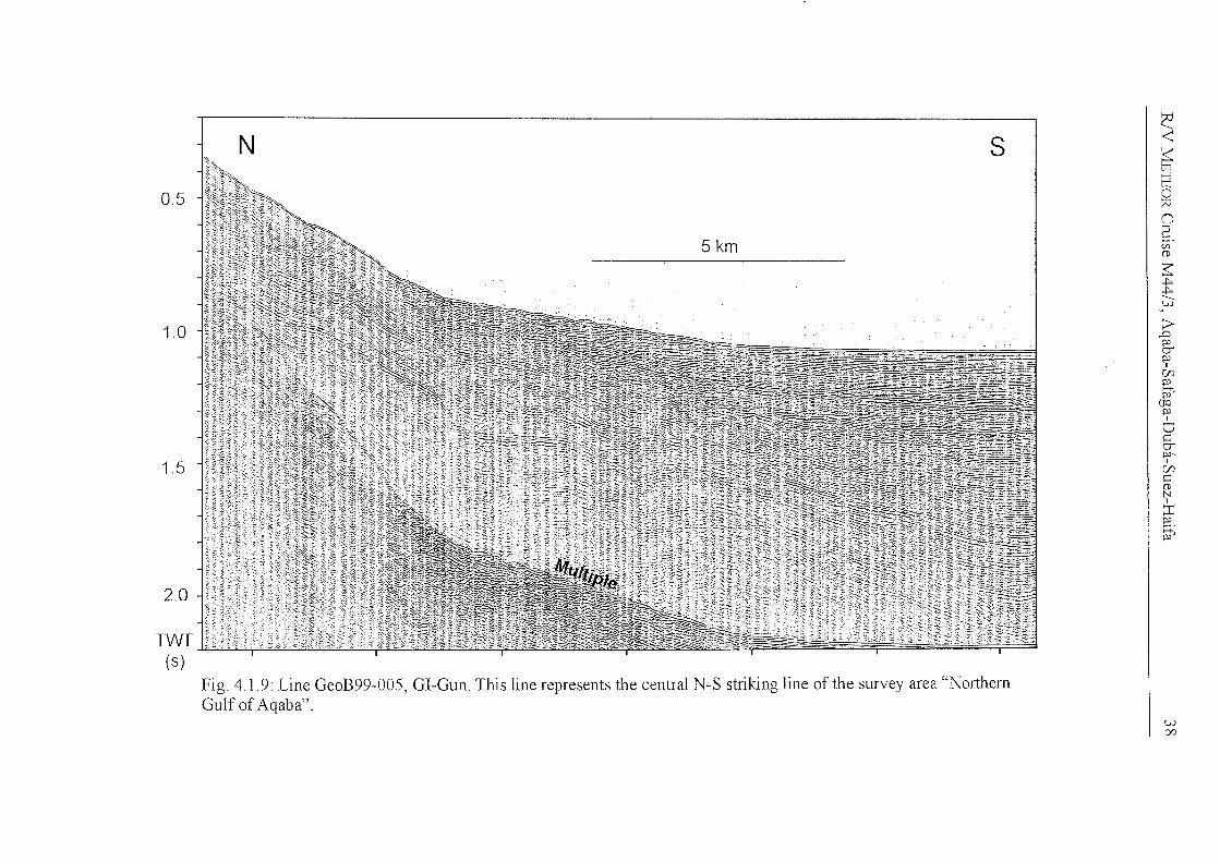
to the eastern margin of the northern Gulf of Aqaba. The central seismic line GeoB99
005 (Fig. 4.1.9) shows the transition from slope sediments, characterized by slides and
slumps intercalated with parallel-layered sediments, to the deposits in the central basin.
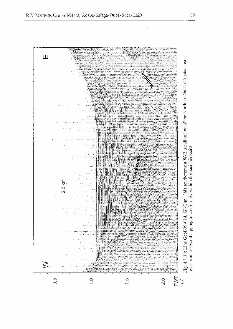
The West-East striking line GeoB99-014 (Fig. 4.1.10) shows a major unconformity that
can be traced in the entire area.
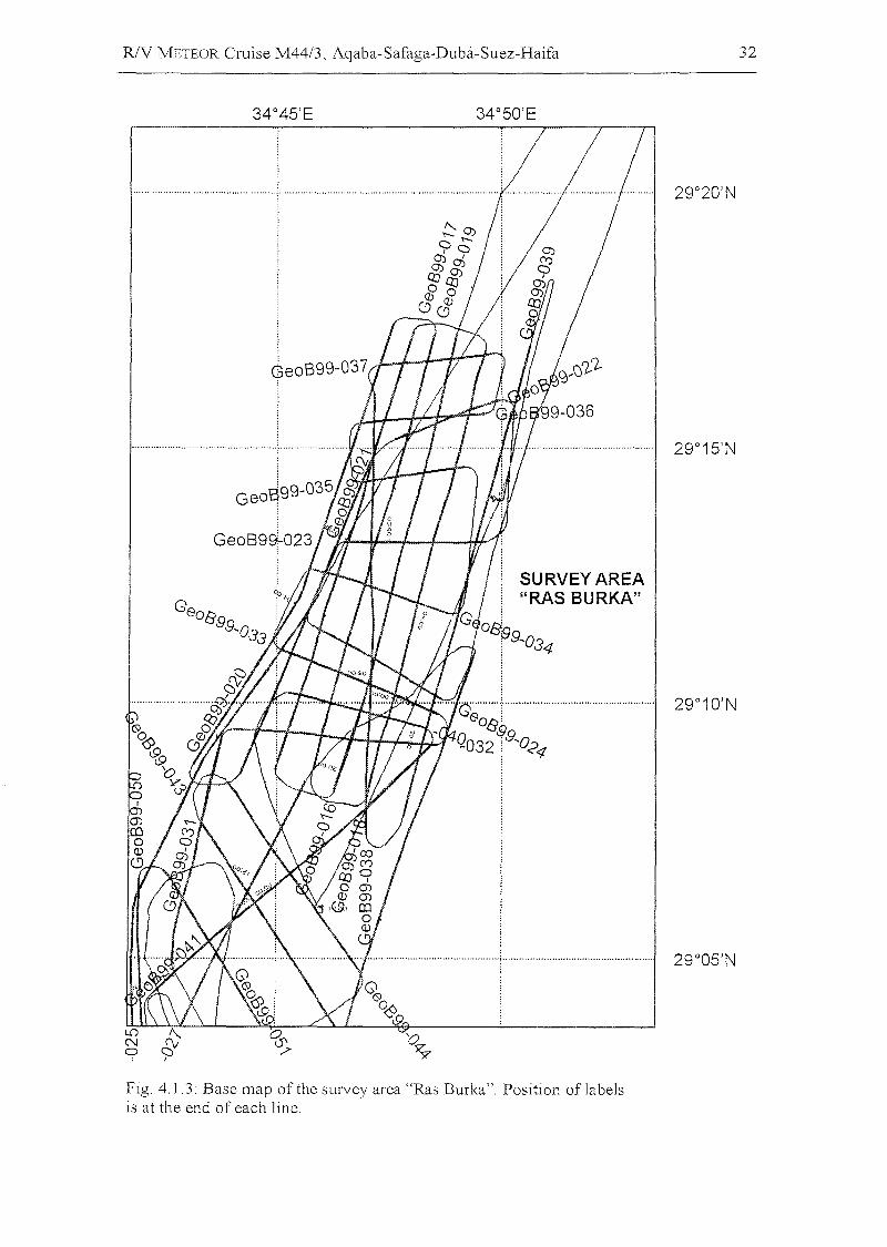
The survey area Ras Burka (Fig. 4.1.3) includes the western marginal block of the
Aqaba Deep. Signal penetration is limited due to the small sediment thickness of just a
few hundred meters (Fig. 4.1.11). A cyclic reflection pattern can be observed on the
southern flank of this crustal block.
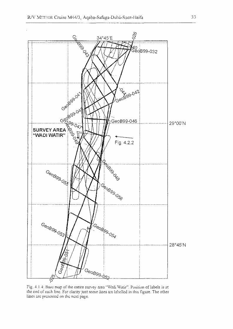
The dense seismic grid at survey area Wadi Watir covers the submarine fan in front of
the wadi and the western marginal block of the Aragonese Deep further south (Fig.
4.1.4; 4.1.5). Lines run parallel and perpendicular to the slope, some lines link the grid to
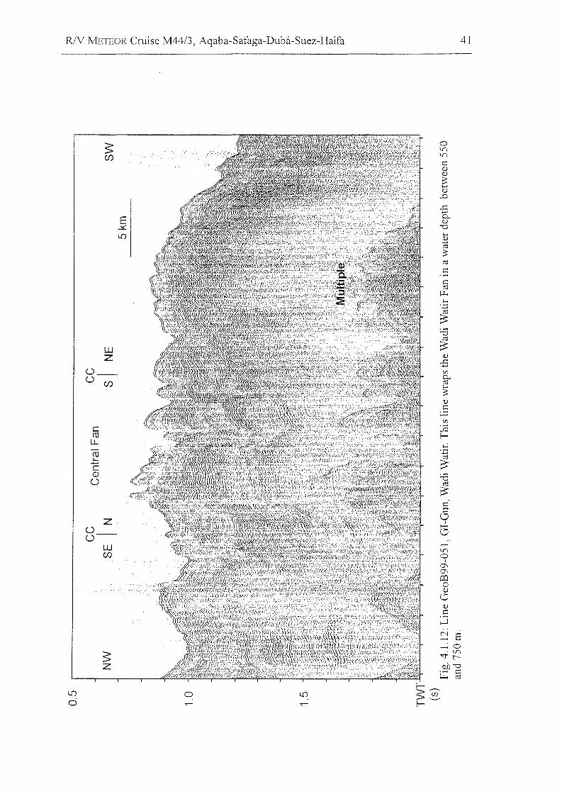
the area Ras Burka. The channels of the fan seem to be correlated with faults (Fig.
4.1.12), their location has not changed as it can be observed in submarine fans located at
passive margins (e.g., Amazon Fan or Bengal Fan).
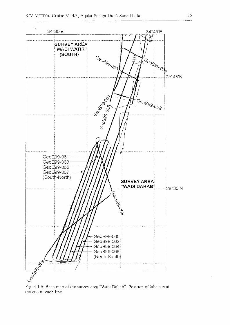
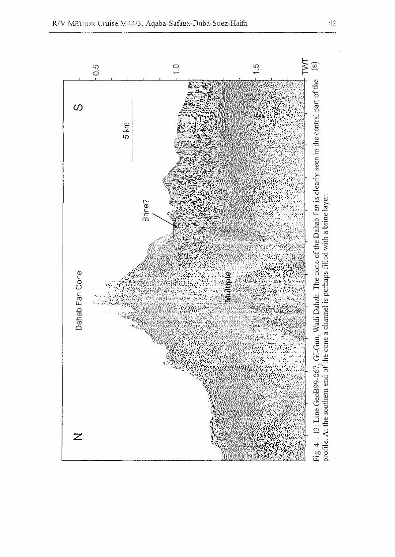
Parallellines cover survey area Wadi Dahab (Fig. 4.1.6). As at the Watir Fan, channels
are connected to faults (Fig. 4.1.13). Continuous reflections within the entire cone can
hardly be found. A dominant channel at the foot of the southern flank may be filled with
brine, which would be a striking result.
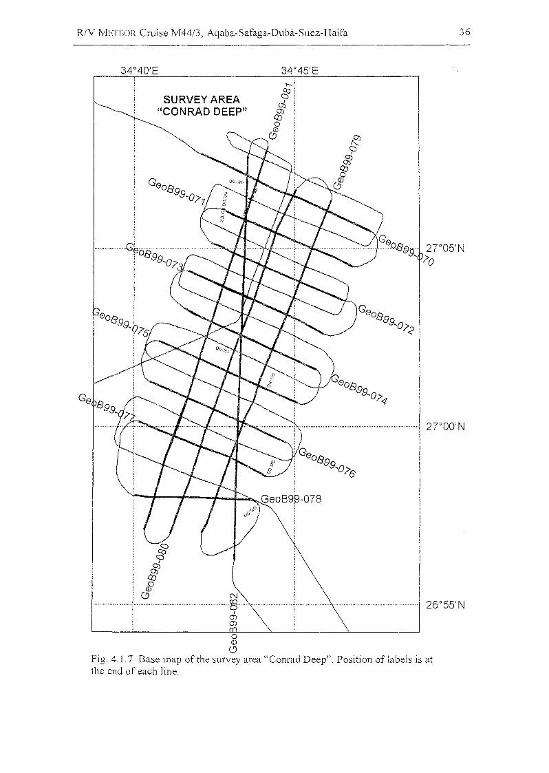
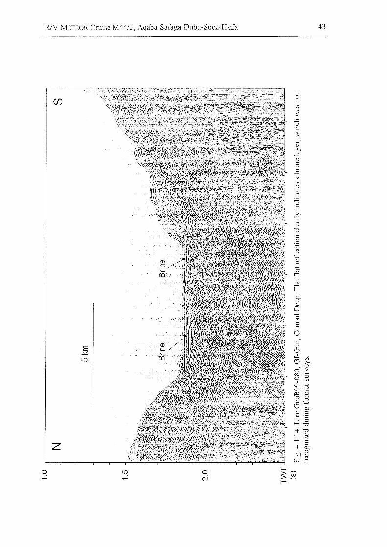
The survey area Conrad Deep was studied in detail (Fig. 4.1.7). The presence of a
brine layer was unknown so far (Fig. 4.4.14). The aim of this survey was to determine
the breakup history of this depression. This was the same goal as for the Shaban Deep
(Fig. 4.1. 8), which was surveyed on the western side (Fig. 4.1.15).
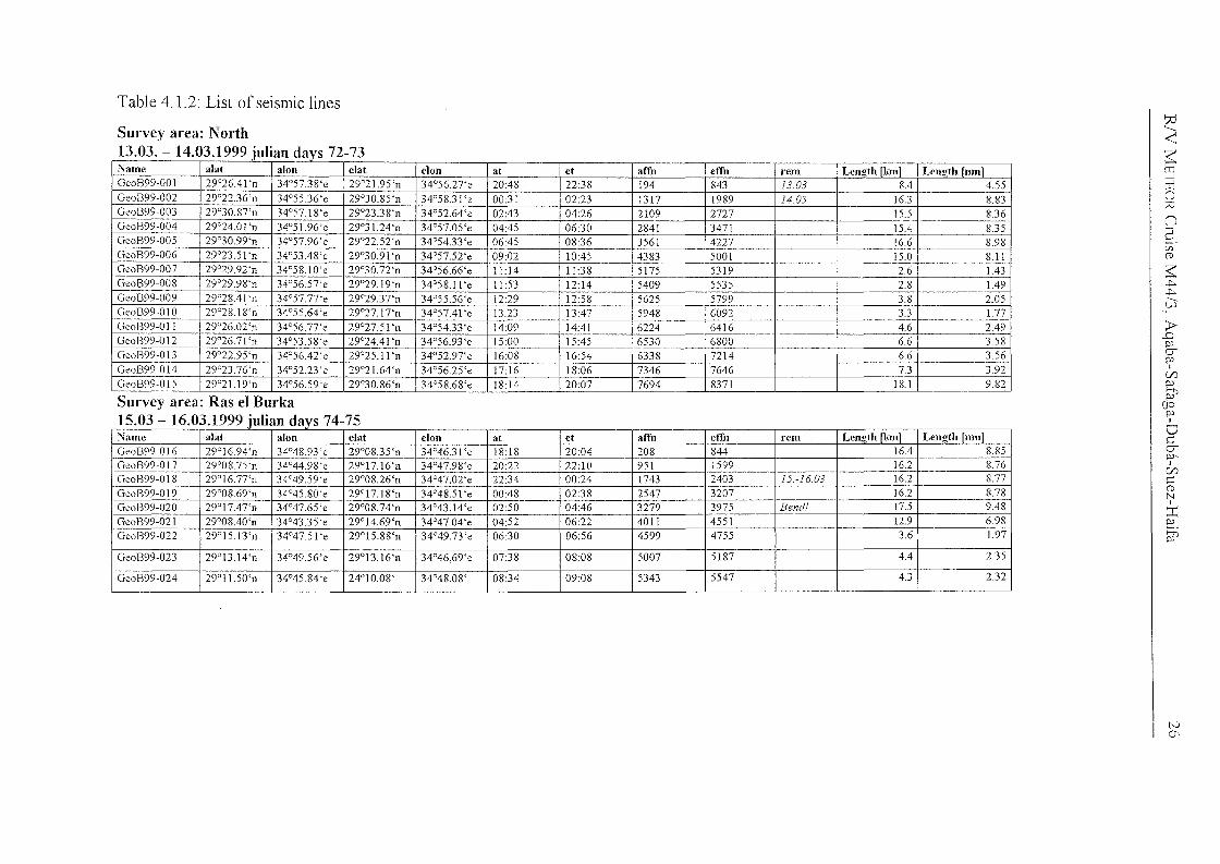
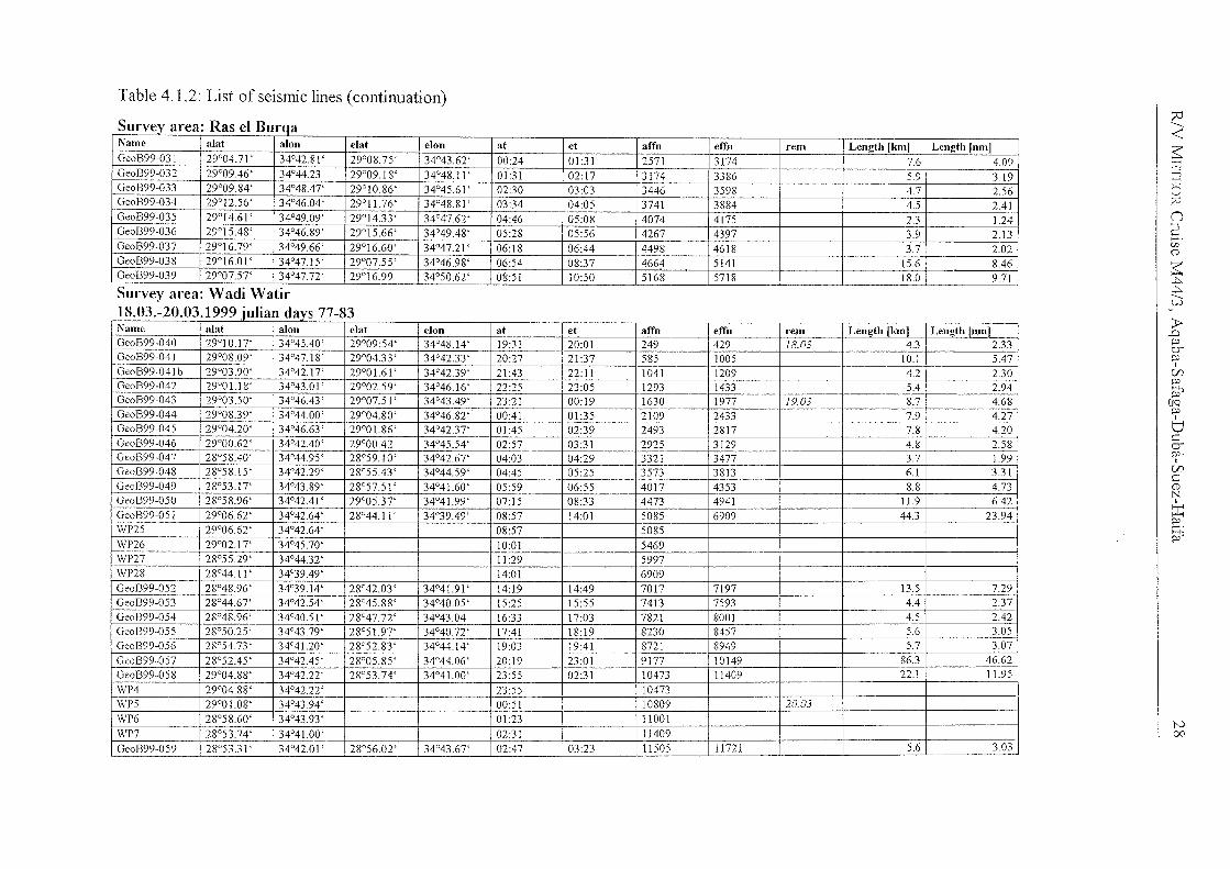
Table 4.1.2: List of seismic lines
~..j:::,...j:::,........v)
~-<~>-jtno(Ci
(J
5.en(j)
;J>,D
&poI
cnpo
Pi'OQpo
bcerpo,I
cnC(j)
N
~po
~
72-73
74-75
clSurvey area: North13.03. - 14.03.1999 iur
Survey area: Ras el Burka15.03 - 16.03.1999 iulian cl
"Name alat al011 elat elon at et aITII eITn rem Len~th [kml Len~th fIlln1GeoB99-016 29°16.94'n 34°48.93 'e 29°08.35'n 34°46.31 'e 18:18 20:04 208 844 16.4 8.85GeoB99-017 29°08.75'n 34°44.98'e 29°17.16'n 34°47.98'e 20:22 22:10 951 1599 16.2 8.76GeoB99-018 29°16.77'n 34°49.59'e 29°08.26'n 34°47.02'e 22:34 00:24 1743 2403 15.-16.03 16.2 8.77GeoB99-019 29°08.69'n 34°45.80'e 29°17.18'n 34°48.51 'e 00:48 02:38 2547 3207 16.2 8.78GeoB99-020 29°17.47'n 34°47.65'e 29°08.74'n 34°43.14'e 02:50 04:46 3279 3975 Bendl 17.5 9.48
GeoB99-021 29°08.40'n 34°43.35'e 29°14.69'n 34°47.04'e 04:52 06:22 4011 4551 12.9 6.98
GeoB99-022 29°15.13'n 34°47.5 I 'e 29°15.88'n 34°49.73'e 06:30 06:56 4599 4755 3.6 1.97
GeoB99-023 29°13.14'n 34°49.56'e 29°13.16'n 34°46,69'e 07:38 08:08 5007 5187 4.4 2.35
GeoB99-024 29°11.50'n 34°45.84'e 24°10.08' 34°48.08' 08:34 09:08 5343 5547 4.3 2.32
.,Name abt alon elat elon at et aITn eITn rem Lenath nunl Lenath fnmlGeoB99-001 29°26.41 'n 34°57.38'e 29°21.95'n 34°56.27'e 20:48 22:38 194 843 13.03 8.4 4.55GeoB99-002 29°22.36'n 34°55.36'e 29°30.85'n 34°58.31 'e 00:31 02:23 1317 1989 1403 16.3 8.83GeoB99-003 29°30.87'n 34°57.18'e 29°23.38'n 34°52.64'e 02:43 04:26 2109 2727 15.5 8.36GeoB99-004 29°24.01 'n 34°51.96'e 29°31.24 'n 34°57.05'e 04:45 06:30 2841 3471 15.4 8.35GeoB99-005 29°30.99'n 34°57.96'e 29°22.52'n 34°54.33 'e 06:45 08:36 3561 4227 16.6 8.98GeoB99-006 29°23.5 I 'n 34°53.48'e 29°30.91 'n 34°57.52'e 09:02 10:45 4383 5001 15.0 8.11GeoB99-007 29°29.92'n 34°58.10'e 29°30.72'n 34°56.66'e 1l:l4 11:38 5175 5319 2.6 1.43GeoB99-008 29°29.98'n 34°56.57'e 29°29.19'n 34°58.11 'e 11:53 12:14 5409 5535 2.8 1.49GeoB99-009 29°28.41'n 34°57.77'e 29°29.37'n 34°55.56'e 12:29 12:58 5625 5799 3.8 2.05GeoB99-010 29°28.18'n 34°55.64'e 29°27.17'n 34°57.41 'e 13.23 13:47 5948 6092 3.3 1.77GeoB99-011 29°26.02'n 34°56.77'e 29°27.51 'n 34°54.33'e 14:09 14:41 6224 6416 4.6 2.49GeoB99-012 29°26.71 'n 34°53.58'e 29°24.41 'n 34°56.93'e 15:00 15:45 6530 6800 6.6 3.58GeoB99-013 29°22.95'n 34°56.42'e 29°25.11 'n 34°52.97'e 16:08 16:54 6338 7214 6.6 3.56GeoB99-014 29°23.76'n 34°52.23'e 29°21.64'n 34°56.25'e 17:16 18:06 7346 7646 7.3 3.92GeoB99-015 29°2 1.I 9'n 34°56.59'e 29°30.86'n 34°58.68'e 18:14 20:07 7694 8371 18.1 9.82
N0\
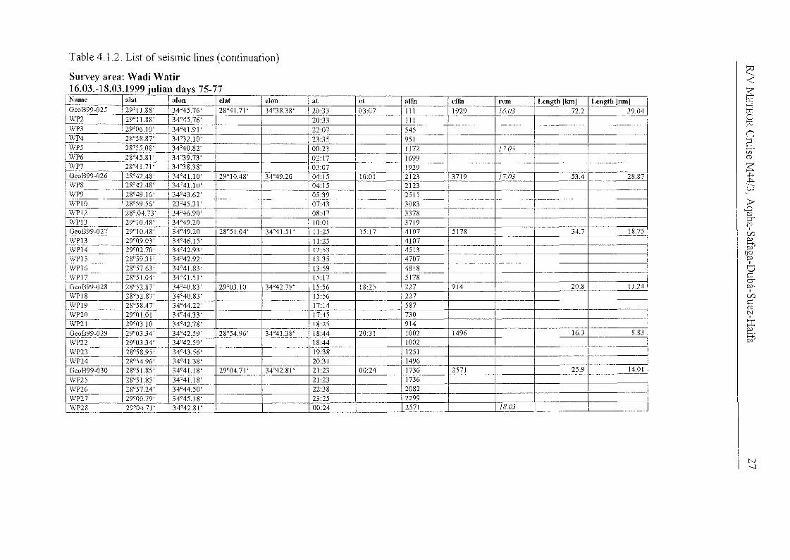
Table 4.1.2: List of seismic lines (continuation)
Survey area: Wadi Watir16.03.-18.03.1999julian days 75-77Name alat alon eJat elon at et affn effn rem Length [km) Length [nm)GeoB99-025 29°11.88' 34°45.76' 28°41.71 ' 34°38.38' 20:33 03:07 I11 1929 16.03 72.2 39.04WP2 29°11.88' 34°45.76' 20:33 1IIWP3 29°06.10' 34°41.91 ' 22:07 545WP4 28°58.87' 34°32.10' 23:35 951\vP5 28°55.08' 34°40.82' 00:23 1172 1703WP6 28°45.81 ' 34°39.73' 02:17 1699WP7 28°41.71 ' 34°38.38' 03:07 1929Geoß99-026 28°42.48' 34°41.10' 29°10.48' 34°49.20 04:15 10:01 2123 3719 1703 53.4 28.87WP8 28°42.48' 34°41.10' 04:15 2123\vP9 28°49.16' 34°43.62' 05:39 2511WPIO 28°59.56' 23°45.31 ' 07:43 3083WPI2 28°.04.73' 34°46.90' 08:47 3378WP13 29°10.48' 34°49.20 10:01 3719GeoB99-027 29°10.48' 34°49.20 28°51.04' 34°41.5 I' ] 1:25 15:17 4107 5178 34.7 1875WPI3 29°09.03' 34°46.15' 11:25 4107-\vP14 29°02.70' 34°42.93' 12:53 4513WPI5 28°59.31 ' 34°42.92' 13:35 4707WPI6 28°57.63 ' 34°41.83' 13:59 4818WPI7 28°51.04 ' 34°41.51 ' 15:]7 5178Geo1399-028 28°52.87' 34°40.83' 29°03.10 34°42.78' 15:56 18:25 227 914 20.8 11.24WP18 28°5287' 34°40.83' 15:56 227WPI9 28°5847' 34°44.22' 17:14 587WP20 29°01.01 34°44.33' 17:45 730WP21 29°0310 34°42.78' 18:25 914Geoß99-029 29°03.34 ' 34°42.59' 28°54.96' 34°41.38' 18:44 20:31 1002 1496 16.3 8.83\vP22 29°03.34' 34°42.59' 18:44 1002WP23 28°58.95' 34°43.56' 19:38 1251WP24 28°54.96' 34°41.38' 20:31 1496Geo1399-030 28°51.85' 34°41.18' 29°04.71 ' 34°42.81 ' 21:23 00:24 1736 2571 25.9 14.01
WP25 28°51.85' 34°41.18' 21:23 1736WP26 28°57.24 ' 34°44.50' 22:38 2082WP27 29°00.79' 34°45.18' 23:25 2299WP28 29°04.71 ' 34°42.81 ' 00:24 2571 IS03
~<:;
~>-JtTJ
%n2r.n(D
~..j::;...j::;.
--u.)
>-,..Cl
&~
I
Vl~
~(JQ~I
dcCT~,
I
VlC(DNI
::c~
~
N--...l
t'-.l00
2:<~>-jtT1oId
nS.Cf)(1)
~..j:>...j:>.
--w
~..D
&p
I
C/lp
P1'OQp
6cerp.
I
C/lC(1)N
~p
~
R
Table 4 1.2: List of seismic lines (continuation)
S
Survey area: Wadi Watir18.03.-20.03.1999 iulian d
_._--- -- - -- ,-Name alat alon elat elon at cl alTn elTn rcm Lcngth [km] Length [nm)GeoB99-031 29°04.71 ' 34°42.81 ' 29°08.75' 34°43.62' 00:24 OUI 2571 3174 7.6 4.09GeoB99-032 29°09.46' 34°44.23 29°09.18' 34°48.11 ' OUI 02:17 3174 3386 5.9 3.19GeoB99-033 29°09.84' 34°48.47' 29°10.86' 34°45.61 ' 02:30 03:03 3446 3598 4.7 2.56GeoB99-034 29°12.56' 34°46.04' 29°11.76' 34°48.81 ' 03:34 04:05 3741 3884 4.5 2.41GeoB99-035 29°14.61 ' 34°49.09' 29°14.33' 34°47.62' 04:46 05:08 4074 4175 2.3 1.24GeoB99-036 29°15.48' 34°46.89' 29°15.66' 34°49.48' 05:28 05:56 4267 4397 3.9 2.13GeoB99-037 29°16.79' 34°49.66' 29°16.60' 34°47.21 ' 06:18 06:44 4498 4618 3.7 2.02GeoB99-038 29°16.01 ' 34°47.15' 29°07.55' 34°46.98' 06:54 08:37 4664 5141 15.6 8.46GeoB99-039 29°07.57' 34°47.72' 29°16.99 34°50.62' 08:51 10:50 5168 5718 18.0 9.71
-
Namc alat alon clat clon at ct alTn elfn ,-cm Lcnoth[Iunl Lcngth rnJ111GeoB99-040 29°10.17' 34°45.40' 29°09:54' 34°48.14' 19:31 20:01 249 429 18.03 4.3 2.33GeoB99-041 29°08.09' 34°47.18' 29°04.33' 34°42.33 ' 20:27 21:37 585 J005 10.1 5.47GeoB99-041 b 29°03.90' 34°42.17' 29°01.61 ' 34°42.39' 21:43 22:11 1041 1209 4.2 2.30GeoB99-042 29°01.18' 34°43.01' 29°02.59' 34°46.16' 22:25 23:05 1293 1433 5.4 2.94GeoB99-043 29°03.50' 34°46.43 ' 29°07.51 ' 34°43.49' 23:21 00:19 1630 1977 19.03 8.7 4.68GeoB99-044 29°08.39' 34°44.00' 29°04.80' 34°46.82' 00:41 01:35 2109 2433 7.9 4.27GeoB99-045 29°04.20' 34°46.63' 29°01.86' 34°42.37' 01:45 02:39 2493 2817 7.8 4.20GeoB99-046 29°00.62' 34°42.40' 29°00.42 34°45.54' 02:57 03:31 2925 3129 4.8 2.58GeoB99-047 28°58.40' 34°44.95' 28°59.10' 34°42.67' 04:03 04:29 3321 3477 3.7 1.99GeoB99-048 28°58.15' 34°42.29' 28°55.43' 34°44.59' 04:45 05:25 3573 3813 6.1 3.31GeoB99-049 28°53.17' 34°43.89' 28°57.51 ' 34°41.60' 05:59 06:55 4017 4353 8.8 4.73GeoB99-050 28°58.96' 34°42.41 ' 29°05.37' 34°41.99' 07:15 08:33 4473 4941 11.9 6.42GeoB99-051 29°06.62' 34°42.64' 28°44.11 ' 34°39.49' 08:57 14:01 5085 6909 44.3 23.94WP25 29°06.62' 34°42.64' 08:57 5085WP26 29°02.17' 34°45.70' 10:01 5469WP27 28°55.29' 34°44.32' 11:29 5997\vP28 28°44.11 ' 34°39.49' 14:01 6909GeoB99-052 28°4896' 34°39.14' 28°42.03' 34°41.91 ' 14:19 14:49 7017 7197 135 7.29GeoB99-053 28°44.67' 34°42.54' 28°45.88' 34°40.05' 15:25 15:55 7413 7593 4.4 2.37GeoB99-054 28°48.96' 34°40.51 ' 28°47.72' 34°43.04 16:33 17:03 7821 8001 4.5 2.42GeoB99-055 28°50.25' 34°43.79' 28°51.97' 34°40.72' 17:41 18:19 8230 8457 5.6 3.05GeoB99-056 28°5473' 34°41.20' 28°52.83 ' 34°44.14' 19:03 19:41 8721 8949 5.7 3.07GeoB99-057 28°52.45' 34°42.45' 28°05.85' 34°44.06' 20:19 23:01 9177 10149 86.3 46.62GeoB99-058 29°04.88' 34°42.22' 28°53.74' 34°41.00' 23:55 02:31 10473 11409 22.1 11.95
\vP4 29°04.88' 34°42.22' 23:55 10473WP5 29°01.08' 34°43.94' 00:51 10809 20.03WP6 28°58.60' 34°43.93' 01:23 11001\vP7 28°53.74' 34°41.00' 02:31 11409GeoB99-059 28°53.31 ' 34°42.01 ' 28°56.02' 34°43.67' 02:47 03:23 11505 1172J 5.6 3.03
~~>-jITJo:;D
n2
~~~
----\J.)
fJ'(1)
>--.D
~poI
Cf)popj'
(fQpoI
tJ~erpo,I
Cf)
~(1)NI
::r:8.pj'
79-83
dDc
Table 4.1.2: List of seismic lines (continuation)
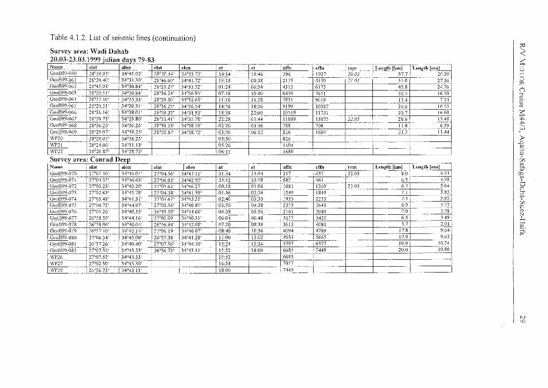
Survey area: Wadi Dahab20.03-23.03.1999 iulian d
S"
Name alat alon dat I elon at et aITn eITn rem Length [kmj Length [nm]Geo1399-070 27°07.30' 34°43.01 ' 27°04.56' 34°47.11 ' 21:54 23:04 217 637 2203 8.0 4.33GeoB99-071 27°04.55' 34°46.63' 27°06.02' 34°42.92' 23:12 23:58 685 961 6.3 3.38Geo1399-072 27°05.23' 34°42.29' 27°03.62' 34°46.27 00:18 01:06 1081 1369 23.03 6.7 3.64Geo1399-073 27°02.63' 34°45.78' 27°04.38' 34°41.59' 01:36 02:26 1549 1849 7.1 3.85Geo1399-074 27°03.48' 34°4L31' 27°01.67' 34°45.55' 02:40 03:30 1933 2233 7.3 3.92Geo1399-075 27°00.72' 34°44.97' 27°02.36' 34°4089' 03:50 04:38 2353 2641 6.9 3.72
Geo1399-076 2T01.26' 34°40.55' 26°59.58' 34°44.68' 04:58 05:56 2761 3049 7.0 3.78Geo1399-077 26°58.59' 34°44.16' 27°00.09 34°40.31 ' 06:04 06:48 3157 3421 6.5 3.49
GeoB99-078 26°58.06' 34°40.04' 26°56.94' 34°42.08' 07:20 08:38 3613 4081 3.7 2.01
Geo1399-079 26°57. 10' 34°42.14' 27°06.19' 34°46.07' 08:40 10:36 4094 4789 17.8 9.64
Ge0899-080 27°06.54' 34°45.00' 26°57.38 34°41.28' 11:00 13:02 4933 5665 17.9 9.65
Ge0899-081 26°57.26' 34°40.40' 27°07.56' 34°44.10' 13:24 15:34 5797 6577 19.9 10.74
GeoB99-082 27°07.52' 34°43.53' 26°56.73' 34°43.11 ' 15:52 18:00 6685 7449 20.0 10.80
WP26 27°07.52' 34°43.53' 15:52 6685WP27 27°02.30' 34°43.30' 16:54 7057WP28 26°56.73' 34°43. I I' 18:00 7449
..Name alat alon elat clon at et aITn eITn rem Len"thlkml Len!!th Inm]Geo1399-060 28°39.93 ' 34°41.05' 28°20.44' 34°33.73' 14:14 18:46 296 1927 20.03 37.7 20.39Geo1399-061 28°20.40' 34°3 L30' 28°4660' 34°41.72' 19:18 00:58 2119 4159 21.03 51.0 27.56Geo1399-062 28°45.93 ' 34°30.84' 28°21.27' 34°33.52' 01:24 06:34 4315 6175 45.8 24.76Geo1399-063 28°20.51 ' 34°30.84' 28°36.24' 34°3693' 07:18 10:40 6439 7651 30.5 1650Geo1399-064 28°27.40' 34°35.33' 28°20.50' 34°32.65' 11:10 14:28 7831 9019 13.4 7.24Geo1399-065 28°20.5 I ' 34°30.3 I' 28°36.25' 34°36.54' 14:58 18:16 9199 10387 30.6 16.55Geo1399-066 28°36.16' 34°38.01' 28°20.32' 34°31.93' 18:38 22:00 10519 11731 30.7 16.60Geo1399-067 28°20.73' 34°29.80' 28°35.41 ' 34°35.78' 22:28 01:44 11899 13075 22.03 28.6 15.48Geo1399-068 28°36.23 ' 34°36.26' 28°30.13' 34°38.58' 02:20 03:36 288 708 11.8 6.39GeoB99-069 28°29.07' 34°38.25' 28°20.87' 34°28.72' 03:50 06:12 826 1680 21.2 11.44WP20 28°29.07' 34°38.25' 03:50 826WP21 28°24.06' 34°31.13' 05:26 1404WP22 28°20.87' 34°28.72' 06:12 1680
N\0
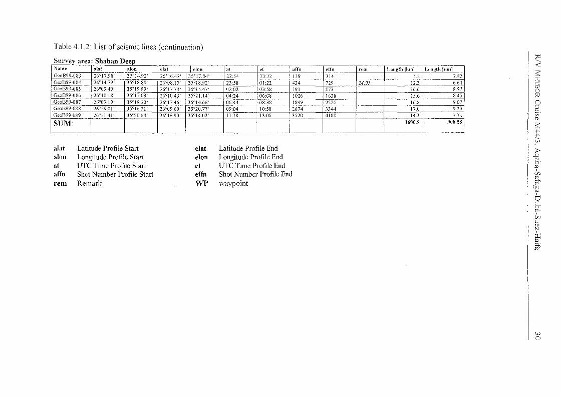
Table 4.1.2: List of seismic lines (continuation)
Name alat alon elat I e10n at et aITn effn rem Length [km] Length [nm]Geo1399-083 26°17.98' 35°14.92' 26°16.49' 35°17.84' 22:54 23:32 J39 3J4 5.2 2.82Geo1399-084 26°14.79' 35°18.88' 26°08.15' 35°1892' 23:58 01:22 434 729 24.03 12.3 6.64Geo1399-085 26°09.49' 35°19.89' 26°17.70' 35°15.47' 02:02 03:58 191 873 16.6 8.97GeoB99-086 26°18.18' 35°17.03' 26°10.43 ' 35°21.14' 04:24 06:08 1026 1638 15.6 8.45GeoB99-087 26°09.19' 35°19.20' 26°17.46' 35°14.66' 06:44 08:38 1849 2520 16.8 9.07Geo1399-088 26°18.01 ' 35°16.21 ' 26°09.60' 35°20.77' 09:04 10:58 2674 3344 17.0 9.20GeoB99-089 26°11.41' 35°20.64' 26°16.90' 35°14.02' 11:28 13:08 3520 4108 14.3 7.72
SUM: 1680.9 908.58
S Shaban D ~<~~o?:InS.CIJ(l>
~.j::..j::.........t...J
alat Latitude Profile Start elat Latitude Profile Endalon Longitude Profile Start eIon Longitude Profile Endat UTe Time Profile Start et UTe Time Profile Endaffn Shot Number Profile Start effn Shot Number Profile Endrem Remark WP waypoint
~~p.:>I
C/Jp.:>
Pt'CIQ
p.:>
6cerp.:>'
I
C/JC(l>NI
::r:~.
Pt'
wo
R/V I'v1ETEOR Cruise M44/3, Aqaba-Safaga-Duba-Suez-Haifa 31
.. : ··································r······· , .
SURVEYAREA
"NORTHERN GUr OF AQABA'~~IJ!
. CJ) t?J 0)
G61b 0° ° &i ~99 Q)
: '00;>
: G61 :
... j ?fJf)[J. :.............. .. .: 'OOf
Q610&
99'07,)
... ,~ .
8Q)og} ~ G610 L'\
I <::r9nQ) ~ ~Oo ~ 7<;
...L : 2 L 29°20'N: : ü ~
: :
Fig. 4.1.2: Base map ofthe survey area "Northern Gulf of Aqaba". Positionoflabels is at the end of each line.
RlV NLETEOR Cruise M44/3, Aqaba-Safaga-Duba-Suez-Haifa 32
SURVEYAREA"RAS BURKA"
0&8
9'°34
.......· o:"" t ··· ..· · ·· .. ··· ·..·.." ·$OL:'>'
°.99Q032: '0<</
Fig. 4. J.3: Base map of the survey area "Ras Burka". Position of labelsis at the end of each line.
R1V METEOR Cruise M44/3, Aqaba-Safaga-Duba-Suez-Haifa 33
. 1' .
'Q !7<7 r-.c,,7J,
I< (;§~)~\J ;
GeO?) I
+---Fig.4.2.2
....G..E3.9.E.3.~.9..::Q.4.? ...;.................................... 290 00'N
... . _ .
- ~~'1B99-032
<:::>I
... ···· .. ··· .. ··· ..·....·i.. ······· ..··········· .. ··· .. ··· .. ··· ..·....·.. ··1· .... ····.. ·.. ··· ..···· .. ·.... ····· ..
t><: PJ)j~Q)o
0°i ~: (").~\J
. ioC6~
i 0 eq....; Q8A .
i t'I \::1'0</lSURVEYAREA~ ?i "WADI WATIR" i l? \71lT"iT,.,..,tH.,L..,: : 0
~
.... j, , ~.................. . ..,. .. ..
~ :... i(9; ; ..
!O~ :
G6br-! : i9i9'O IQ9 j Z
~'O: i 6J
:s~.:: Gi!9o,",\ Q9: ~'O! 0'6'
·..T· · ·..· · · · ·r· ~ ; ..
Fig. 4.1.4: Base map of the entire survey area "Wadi Watir". Position oflabels is atthe end of each line. For clarity just same lines Me labelled in this figure. The otherlines are presented on the next page.
RlV METEOR Cruise M44/3, Aqaba-Safaga-Duba-Suez-Haifa 34
... j 29°00'NCENTRAL
SURVEY AREA"WADI WATIR"
..-..: , - -.............. ... " ~.
GeoB~9-025
GeoB~9-050 --tJ'"i"t--Y-+-l-LilL........ G.§.Q.S.~~!::·.Q2.l..:~.·::::::~.· :::: ~ ".
GeoBQ9-057 --+-+--+~Ge0 B9.9-058 --t-t---\>+i
GeoB~9-029J~~~~~l1J~GeoB~9-028Ge0 B~9-030 -+-FI--'<;--Il!'-I----#-~l
GeoB~9-051GeoBQ9-026
o L()Q.) C\Io 0,
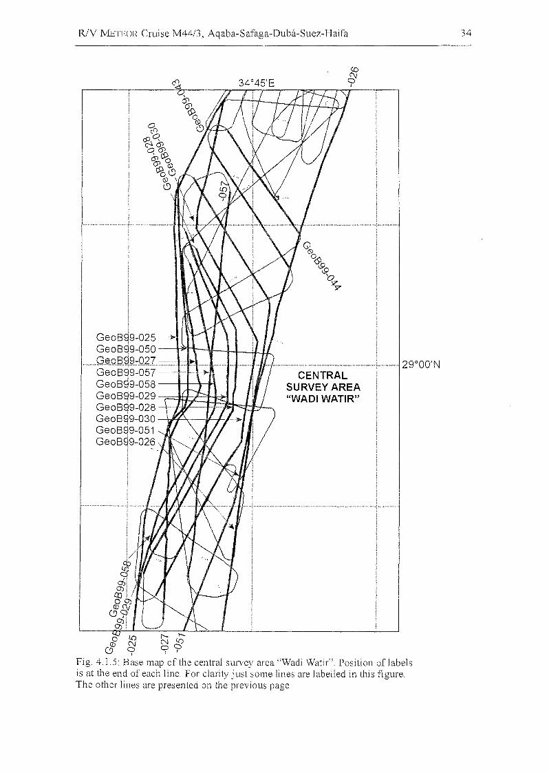
Fig. 4.1.5: Base map of the central survey area"Wadi Watir". Position of labelsis at the end of each line. For clarity just some lines are labelled in this figure.The other lines are presented on the previous page.
R/V METEOR Cruise M44/3, Aqaba-Safaga-Duba-Suez-Haifa 35
co:(\j~
····e··!··············I j
····.···············;..············28°45'N
$U RVEY AREAi!"WADI DAHAB~ 0'.........................~ ! 28 30 N
Q : .o :%J1~:
b6>rp
........... '< : ,; ..
"'6"U'RVE~("AR"E~'Är""""'"f'WADI WATIR":: (SOUTH) :
0......>J
O)OS I.rjg; 0J......................................! j 00.. ; """:'" ; .
: : Cl:): :. . 0 .
rJ
. .··· .. ,,···· ..·.. ····· .. ··· .. ·,· ,"t····· ..,..·.. ·· · ··· .. ·· ,.., !." , ..
......................................_ .
·..············· .. ··· ..G·~·~·J~~·~;~·~···· .. ········ .. ··· .. ······1···· ....
Geo8,99-063 :GeoS99-065Ge0899-067 ---}lo
(South-North)
Ge0899-060 i
Ge0899-062 :Ge0899-064 :Ge0899-066 :(North-South j................# , , , , .
gy0°
Fig. 4.1.6: Base map ofthe survey area "Wadi Dahab". Position of labels is atthe end of each line.
R/V J'vIETEOR Cruise M44/3, Aqaba-Safaga-Duba-Suez-Haifa 36
2rOO'N
G.......""., .......".. ",, ...... ,,· ..f!.Q&§fX Jo7°05'N
SURVEYAREA"CONRAD DEEP"
'''''".." G'~." .. , " "''" ,, .., 089: 9~07J
&
I! C!J N :""·,"" ·".."..(",,··,,··,,···· ·..·..·,,···,,,,··,,"" ·9"'''·· , " '["" " " ,,", ,.. ,.,,"" " ".. 26°55'N: CD:
CD
oQ)
GFig. 4.1.7: Base map of the survey area "Conrad Deep". Position of labels is atthe end of each line.
RlV METEOR Cruise M44/3, Aqaba-Safaga-Duba-Suez-Haifa 37
A~ 4.2.4
: :"r'" .. ·· ..·~ .. ·· ·..· ·..··1· .. ·· ..·..·..· ··
Q °o~~~~o~~(5)
SURVEY AREA !"SHABAN DEEP" i
GI$)Os\9.~'O .
<9~ i...................................................... '1" .
....................................................... ~.. • '1" -.- .
-.::tcoo
I0)0)
cooQ) :....................................................... j·············..··························(9··········i· ~ .
. : i
Fig. 4.1.8: Base map ofthe survey area "Shaban Deep". Position of labels isat the end of each line.
~
N S I I<~>--JtrJ
0.5 I I 0:::vn2w·(1)
~~~
---VJ
1.0 I ,1;p'a-p'
ICf)p'
!P(JQp'
I
Uca-p'o
1.5 Icnc(1)NI
:r::p'
~
2.0
Twr~~~~~~(s)
Fig. 4.1.9: Line GeoB99-005, GI-Gun. This line represents the central N-S striking line of the survey area "NorthernGulf of Aqaba".
VJ00
RlV METEOR Cruise M44/3, Aqaba-Safaga-Duba-Suez-Haifa 39
w
L[)
oo L[) o
N
.j:;.o
2.0
22<~>-J
St05
tT107J
N5 km n
S.[IJ
CD
~.j:;..j:;.
------l-Jv
;:t>..D
1.0 Ib-P'I
ffJP'Pi'
(fQP'I
0CerP"I
ffJ
1.5 I ~N
I
P::P'
~
···.;·.·.Y."'''H TWT(s)
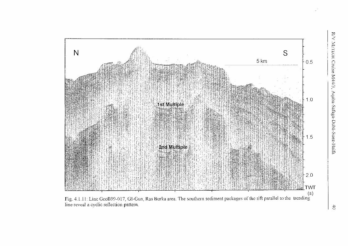
Fig. 4.1.11: Line GeoB99-017, GI-Gun, Ras Burka area. The southern sediment packages of the rift parallel to the trendingline reveal a cyclic reflection pattern.
R/V METEOR Cruise M44/3, Aqaba-Safaga-Duba-Suez-Haifa 41
s 0lf1
Cf) lf1
eQ)Q)
::::......Q)
..0
...c......E 0...
Q)
..::.:: "0L.() I-<
Q)
~::::roe.-ero
f-L<I-<.-......ro~:.:aro
W ~Z Q)
...c......ü __ VJ.
Ü 0...Cf) ro
I-<
::::Q)
e:.::::
VJ.
c .-...s:::(iJ E-<
l.L~
(iJ
~'---C(]) :.:aü ro
~e~
ÖZ I
Ü.......(J
ü ~
w ,..-<
lf1Cf) 0
I0\0\CO0Q)
(JQ)
c~N 8,..-<
'--;0
S. lf1
71:"--
Z ob "0.- Cf-L< ro
L() 0 L.() ~~0 ~ ~ f-
RlV METEOR Cruise M44/3, Aqaba-Safaga-Duba-Suez-Haifa 42
(1)Co
Uccu
LL.0cu.ccuo
z
R/V J\!1ETEOR Cruise M44/3, Aqaba-Safaga-Duba-Suez-Haifa
.......
Cf)0:::U'l(Ij
~..c()
:.2~\.-l'V
~V:::.e:
..0(Ij
U'lV.......(Ij()
:.a:::.-:>.
-c:(Ijv
Us:::0
..0()v
y::::;VI-
~y::::;V
..cf-<0-vvQ"Cl(IjI-:::0
Us:::~
E c3.::c. I
L()...... vi0 :>.
0'vr:00 ;:l0
I U'l
0\ I-0\ Vt:Q §0v<EOb.()V :::s::: .e:~ ;:l
"Cl
"i" "Cl.-< V
N.-< ·cZ "i" oi)ob 0
()
~VI-
0 l!) 0 ~ --Cf)
"""" """" N f- ----
43
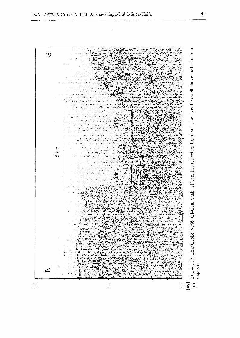
R/V METEOR Cruise M4413, Aqaba-Safaga-Duba-Suez-Haifa 44
tn..--<
..--<~
.."f .Vi.0
.~D fr~'"O
z
Cf)
o
RlV METEOR Cruise M44/3, Aqaba-Safaga-Duba-Suez-Haifa
4.2 PARASOUND and HYDROSWEEP(e. Hübscher and Shipboard Scientific Party)
4.2.1 Introduction
45
The hydroacoustic systems of RlV METEOR Cruise M44/3 were continuously operated
10 collect sediment echosounder and swath sounder data from the deposits in the
working areas Gulf of Aqaba, the northern Red Sea, and the eastern Mediterranean Sea.
The HYDROSWEEP swath sounder and the PARASOUND sediment echosounder are
permanently installed on RlV METEOR. The HYDROSWEEP system provides topographic
information at a width of twice the water depth. The PARASOUND sediment echosounder
uses frequencies around 4 kHz, which allow signal penetration between 10 and 100 m
depending on sediment composition and grain size. Digital echosounder data were
routinely collected with the help of all scientists onboard by participating in the 24-hour
watch duties.
4.2.2
4.2.2.1
Instruments
PARASOUND
The PARASOUND system works both as a low-frequency sediment echosounder and as a
high-frequency narrow beam sounder to determine the water depth. It makes use of the
parametric effect, which produces additional frequencies through nonlinear acoustic
interaction of finite amplitude waves. If two sound waves of silnilar frequencies (here 18
kHz and e.g. 22 kHz) are emitted simultaneously, a signal of the difference-frequency
(e.g. 4 kHz) is generated for sufficiently high primary amplitudes. The new component is
travelling within the emission cone of the original high frequency waves, which are
limited to an angle of only 4° for the equipment used. Therefore, the footprint size of 7%
of the water depth is much smaller than for conventional systems and both vertical and
lateral resolution are significantly improved.
The PAIZASOUND system is permanently installed on the ship. The hull-mounted
transducer array has 128 elements on an area of ~1 m2 1t requires up to 70 kW of
RJV METEOR Cruise M44/3, Aqaba-Safaga-Duba-Suez-Haifa 46
electric power due to the low degree of efficiency of the parametric effect. In 2
electronic cabinets, beam forming, signal generation and the separation of primary (18,
22 kHz) and secondary frequencies (4 kHz) is carried out. With the third electronic
cabinet in the echosounder control room the system is operated on a 24-hour watch
schedule.
Since the two-way travel time in the deep sea is long compared to the length of the
reception window of up to 266 ms, the PARASOUND System sends out a burst of pulses
at 400 InS intervals, until the first echo returns. The coverage of this discontinuous mode
depends on the water depth and produces non-equidistant shot distances between bursts.
On average, one seismogram is recorded about every second providing a spatial
resolution on the order of a few meters on seismic profiles at 4.9 knots.
The main tasks of the operators are system and quality control and the adjustment of the
start of the reception window. Because of the limited penetration of the echosolmder
signal into the sediment, only a short window elose to the sea floor is recorded.
In addition to the analog recording features with the b/w DESO 25 device, the
PARASOUND System was equipped with the digital data acquisition system ParaDigMA,
which was developed at the University of Bremen (Spieß, 1993). The data were stored
using the standard, industry-compatible SEGY-format. The 486-processor based PC
allows the buffering, transfer, and storage of the digital seismograms at very high
repetition rates. From the emitted series of pulses, usually every second pulse could be
digitized and stored, resulting in recording intervals of 800 ms within a pulse sequence.
The seismograms were sampled at a frequency of 40 kHz, with a typical registration
length of 266 ms for a depth window of ~200 m. The source signal was a band limited,
2-6 kHz sinusoidal wavelet of 4 kHz dominant frequency with a duration of 2 periods
(~500 ~lS totallength).
Already during the acquisition of the data an online processing was carried out. For all
profiles PARASOUND sections were plotted with a vertical scale of several hundred
meters. Most of the changes in window depth could thereby be eliminated. From these
plots a first impression of variations in sea floor morphology, sediment coverage and
sedimentation patterns along the ships track could be gained To improve the signal-to
noise ratio, the echogram sections were filtered with a wide band pass filter. In addition
R/V METEOR Cruise M44/3, Aqaba-Safaga-Duba-Suez-Haifa 47
the data were normalized to a constant value much smaller than the maximum average
amplitude, to amplify in particular deeper and weaker reflections.
4.2.2.2 HYDROSWEEP
The multibeam echosounder HYDROSWEEP on R/V METEOR was routinely used during
the cruise and serviced by the system operator and the electronics engineers. During a
24-hour watch the scientific crew operated continuously both the HYDROSWEEP and the
PARASOUND echosounder systems in parallel. The HYDROSWEEP System worked without
major technical problems. The multi-beam sounder provided a complete coverage of the
sea floor topography with a swath width of twice the water depth. The data quality was
generally good with data losses at higher speeds and under high-sea conditions.
4.2.3 First Results
As an example PARASOUND sections from different working areas are shown in the
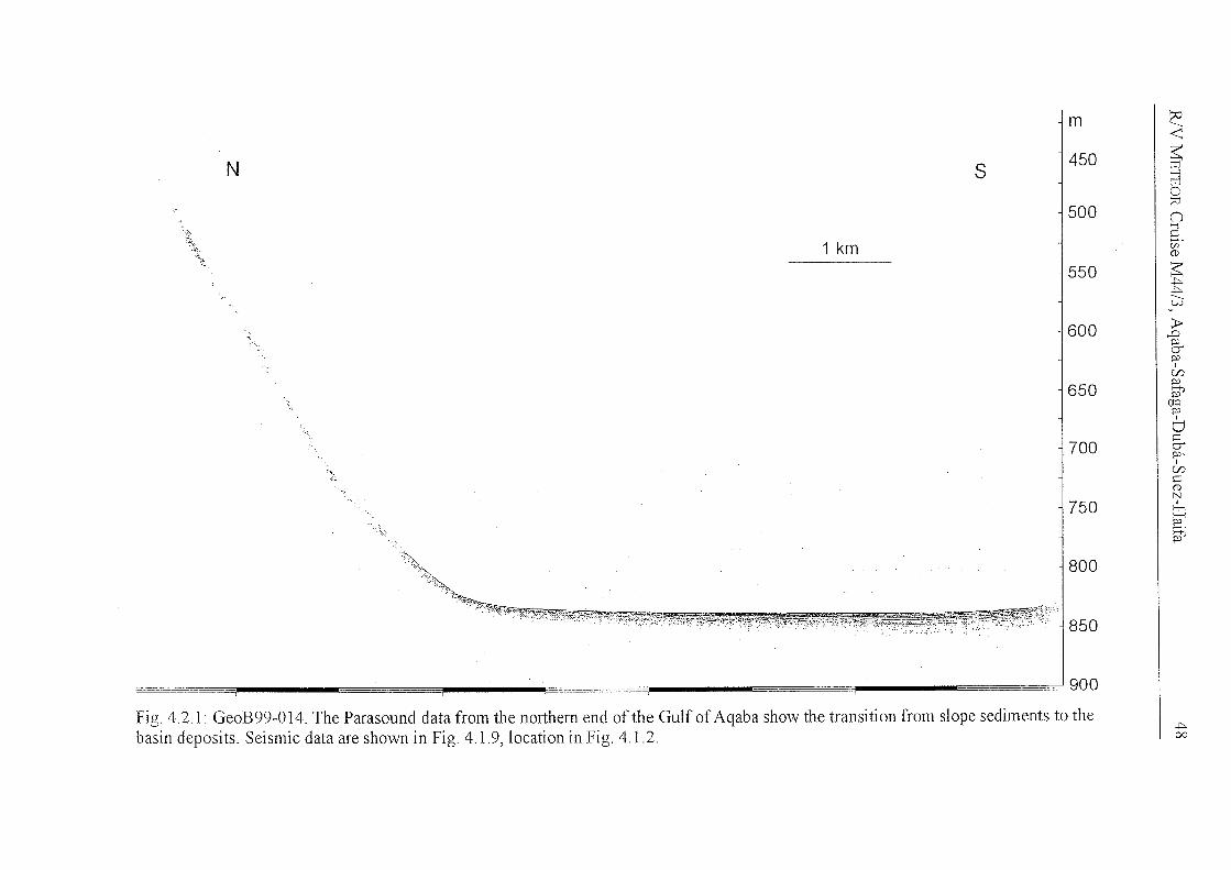
following figures. Fig. 4.2.1 was selected to show the transition from slope sediments,
characterized by diffraction hyperbolae, to the flat lying uppermost sediments. The
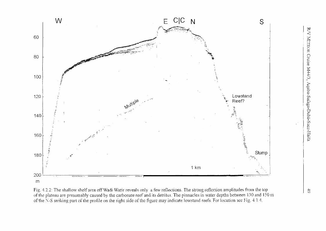
shallow shelf area off Wadi Watir reveals only a few reflections (Fig.4.2.2; for location
see Fig. 4.1.4). It is presumably the strong reflection coefficient of the carbonate that
prevents signal penetration. Possible indicators for low stands are only seen on the
southern flank, where pinnacle shaped features may indicate lowstand reefs. Presumably
due to a density gradient over some wavelengths no reflections from the brine layer were
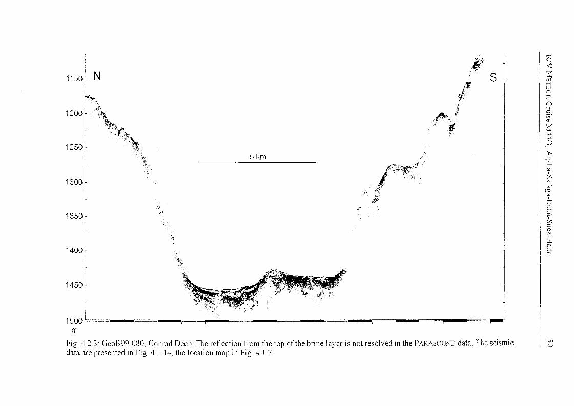
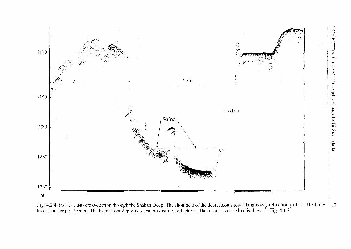
observed in the Conrad Deep (Fig. 4.2.3). Reflections from the bottom of the depression
are diffuse, similar to the Shaban Deep (Fig. 4.2.4). Here, the top of the brine causes a
sharp signal. The PARASOUND data from the eastern slope of the Red Sea just east of the
Shaban Deep elucidates the difficulty to detect appropriate sites for gravity coring (Fig.
4.2.5).
N
',~:;
s
1 km
m
450
500
550
600
650
700
750
800
850
c:-<~>--JtrJo?O(J
E.CIl(1)
~~~
---v.l
E'&poI
Cf)po
it'(JQpo
6cerpo,I
Cf)
C(1)N
6::2::.it'
===900
Fig. 4.2.1: GeoB99-014. The Parasound data from the northern end ofthe Gulf of Aqaba show the transition from slope sediments to thebasin deposits. Seismic data are shown in Fig. 4.1.9, location in Fig. 4.1.2.
~00
60
80
100
120
140
160
180
.'
"':~
t,,~.
:.(
':"
w
f'
",'
,r
~;':' ..
\\.\\(\0 .,,'~0\ '
,.1":;".':'.
,,', .,{': -
E eie N
I'\':;;<,r~t\,~~\::~
....:~~
.~.~.~
''!ll-'~
1 km
i
:.
~:;..
t~1';>
;~
LowstandReef?
s
Siump
c:-<
~trJo!0()
S.VJ(D
~..,...,.--l,;)
;J>,D
&~I
C/1~
!PCfQ~I
t:Jcer~,
I
C/1C(DNI
~~
~
200I";... 1
m
Fig, 4,2,2' The shallow shelf area off Wadi Watir reveals only a few reflections, The strong reflection amplitudes from the topof the plateau are presumably caused by the carbonate reef and its detritus, The pinnades in water depths between 130 and 150 mofthe N-S striking part ofthe profile on the right side ofthe figure may indicate Iowstand reefs. Für Iocation see Fig, 4,1.4.
..,.\0
1150
1200
1250
1300
1350
1400
1450
N
r?;"',.".,,,,-
'~~;;
<:::.~',:()
5km
-r"
,~r~';
[l
11~.'::~"" ..i-r"
"1s
~<~>-JtrJo:::vnS(/)(1)
~.j::,..j::,.
---w
>-..DPUP
IC/).p
Pi'(JQp
6cup,I
C/).
C(1)NI
~P
~
1500I",;"m
Fig, 4,2,3: GeoB99-080, Conrad Deep, The reflection from the top ofthe brine layer is not resolved in the PARASOUND data, The seismicdata are presented in Fig. 4.1.14, the location map in Fig. 4.1.7.
V1o
c:<
~lI1C?Jn5.VJ(l)
~~~
--uJ
E'poerpo
I[fJpo
P?(JQpo
I
Ucerpo,
I
[fJC(l)
N
~po
~
J~
no data
1 km
}~.
.~~~-
,~
: .. ,....
,f'"*
J~;1:."
.zj!frf~ ..
1280
1130
1230
1180
1330
m'
Fig. 4.2.4: PARASOUND cross-section through the Shaban Deep. The shoulders ofthe depression show a hummocky reflection pattern. The brinelayer is a sharp reflection. The basin floor deposits reveal no distinct reflections. The 1ocation of the line is shown in Fig. 4.1.8.
VI>--'
600
700
800
900
1000
1100
1200
sw
5 km
7:-. .-~
-~
NE
~~~o~
nE.[/l(1)
~.j:::..
----vJ
1;>&poI
C/).po
PPCfQpo
6cerpo,I
C/).C(1)N
~po
~
1300 L ;-;="1"'"* ~==r-F~~ ~-~_ ,.-;=_ _ puac -.0lIl _ _=t-",- _ -.0lIl _ ._ ,_ _-- _. _-""I"'"
m
Fig, 4.2.5: This PARASOUND transect shows the rough and hummocky sea floor in working area II in the eastem Red Sea. The best site forcoring was at the plateau in a water depth of 600 m at the eastern end of the profile.
\Jlt0
R1V 1VlETEOR Cruise M44/3, Aqaba-Safaga-Duba-Suez-Haifa 53
4.3 Sediment Sampling
(M. Abu-Ouf, Y. M. Al-Hazmi, S. Al-Rousan, H. W. Arz, B. Donner,
T. Felis, K. A. Kadi, H. Kuhlmann, T. Lützeler, M. O. Moammar, C.
Moos)
At 37 stations in the northern Gulf of Aqaba, the northern Red Sea, and the eastern
Mediterranean Sea we sampled sea floor sediments by means of a giant box corer
(GKG), a multicorer (MDC), a gravity corer (SL6, SL12, SL18), and a piston corer
(KL12, KL18) from water depths between 135 and 1500 m. All details are given in the
station list (Appendix I). In the northern Gulf of Aqaba (Jordan, Israel) one box core
sampie, 16 multicores, and 13 gravity cores were retrieved (Fig. 3.2). Along three
profiles extending from the Saudi Arabian coast to the central axis of the northern Red
Sea altogether 16 multicores, 18 gravity eores, and 6 piston eores were reeovered (Fig.
3.4). During the last part (In) of Leg M44/3, 4 multieores and 4 piston cores were
retrieved in the eastern Mediterranean Sea (Israel) (Fig. 3.5).
4.3.1 Giant Box Corer
In order to sampie relatively eoarse-grained surfaee sediment the box earer was used at
one station (29°30.64' N, 34°58.98'S, 326 m water depth). With a surface area of
50 x 50 cm the box corer reeovers the uppermost max. 50 em of sediments. Once on
board, the overlying water was earefully removed from the box eorer and the surface
sediments (0-1 em) were photographed and sampled as follows:
- 3 eores (~ =12 em) as archive,
- 400 cm2 for analysis of foraminifera, stained with rose bengal,
- 200 cm2 for analysis of organic carbon
The front eover of the box was subsequently removed, the sediment c1eaned and
photographed. Two series of syringes were taken at a 1 cm depth interval for
faunallstable isotope analysis and organie geoehemistry and physieal properties analysis.
Finally, bulk samples of the uppermost 5 em and the intervals 5-10 em, lO-20 em, and
20 em to the base of the box were taken in order to eolleet the macro fauna llsing a
1 mm mesh sieve.
RJV METEOR Cruise M44/3, Aqaba-Safaga-Duba-Suez-Haifa
4.3.2 Multicorer
54
The main tool for the sampling of undisturbed surface sediment and the overlying bottom
water was the multicorer (IvIUC, GeoB) equipped with six large (diameter of 10 cm) and
four smaller (diameter of 6 cm) plastic tubes of 60 cm length. During M44/3, part III
(the last four stations) a second model, the MUC II (GPITü), with only 8 but large tubes
was used. Depending on the working area and the core recovery, the tubes were
generally sampled as folIows:
-11arge tube, cut into 1 cm thick slices and frozen for orgamc carbon (TOC)
geochemistry,
-Ilarge tube, cut into 1 cm thick slices for the surveys on dinoflagellates,
-1 small and 2 large tubes, cut into 1 cm thick slices and stained with rose bengal for
faunal investigations
- surface of 1 large tube (first cm) for diatom and radiolaria investigations, stained with
ethanol/methanol,
for M44/3 I
-3 large tubes (one without surface) and 3 small tubes were frozen as archive cores,
for M44/3 II
-11arge tube, cut in 0.5 cm thick slices for investigation of foraminiferal composition,
-2 large tubes (one without surface) and 1 small tube were frozen as archive cores,
-1 small tube, cut into 1 cm thick slices for the Saudi Arabian authority as reference
sampIe
-1 small tube, cut into 1 cm thick slices far Dr. Khalid A. Kadi, Saudi Arabia.
50 ml bottom water sampIes for stable carbon and oxygen isotopes were taken at each
station where sediment was recovered.
In total, the multicorer was employed 40 times. More detailed sampling information is
given in Table 4.3.1.
R/V METEOR Cruise M44/3, Aqaba-Safaga-Duba-Suez-Haifa
Table 4,3,1: MuIticorer sampling M44/3
55
SedimentGeoB Latitude Longitude Water depth recovery RemarksNo. N E (m) (cm)
M44/3 I, Gult' ot' Agaba
5801-2 29°24,90' 34°54,70' 826 m 40 cm 6 big, 4 sma11 tubes fi11ed5801-3 29°24,90' 34°54,70' 826 111 40 C111 6 big, 4 sma11 tllbes fi11ed5802-2 29°30,45' 34°57,68' 396 m 43 cm 6 big, 4 sma11 tubes fi11ed5803-2 29°30,96' 34°58,02' 301 111 7cm 6 big, 3 s111a11 tubes filled5804-2 29°30,07' 34°57.44' 463 m 41cm 6 big, 4 sma11 tubes fi11ed5804-3 29°30,10' 34°57.40' 464 m 40 cm 6 big, 4 sma11 tubes fi11ed5806-2 29°22.75' 34°53.30' 838 m 40 C111 5 big, 4 sma11 tubes fi11ed5807-2 29°28.81' 34°56.78' 646 111 39 cm 6 big, 4 sma11 tubes fi11ed5808-3 29°29.06' 34°56.35' 576 111 43 C111 6 big, 4 sma11 tllbes fi11ed5809-2 29°30AO' 34°57.36' 401 111 41 cm 6 big, 4 sma11 tllbes fi11ed5810-3 29°30.21' 34°57.73' 441 m 35 C111 6 big, 4 sma11 tllbes fi11ed5811-1 29°24.86' 34°54.70' 827 m 39 cm 6 big, 4 sma11 tubes fi11ed5812-2 29°31.14' 34°57.79' 269 m 15 cm 6 big, 4 sma11 tubes filled5813-1 29°31.32' 34°57.90' 240 m 19 cm 6 big, 4 sma11 tubes fi11ed5814-2 29°31.71' 34°58.08' 140 m - no core recovery5814-3 29°31.72' 34°58.09' 135m 6cm 6 big, 4 sma11 tllbes filled
M44/3 II, Northern Red Sea, Saudi Arabia
5823-1 26°25.26' 35°40.19' 789 m 33 cm 6 big, 4 s111a11 tubes fi11ed5824-1 26°29.12' 35°49.52' 587 m 33 cm 6 big, 4 sma11 tllbes fi11ed5825-1 26°30.47' 35°56.94' 1031 m 31 cm 5 big, 4 sma11 tllbes fi11ed5827-1 26°19.11' 35°31.20' 959 m 9cm 4 sma11 tllbes filled5828-1 26°20.78' 35°24.13' 1072 m 11-35 cm 5 big, 4 sma11 tubes fi11ed5831-1 27°05.30' 35°33.98' 884 m 32 cm 5 big, 4 slllall tllbes fi11ed5832-1 27°03.20' 35°24.32' 628 m 30 cm 5 big, 4 sma11 tllbes fi11ed5832-3 27°03.18' 35°24.31' 628 m 30 cm 6 big, 4 small tllbes fi11ed5835-4 26°15.49' 35°20.02' 1328 m - no surface, no sampIes5835-5 26°15.52' 35°19.99' 1328 m 2 kg 6 big, 4 small tubes fi11ed5835-6 26°15.50' 35°19.99' 1328 m 2 kg 6 big, 4 small tubes filled5836-1 26°12.60' 35°21.55' 1474 m - no surface, no sampIes5836-3 26°12.61' 35°21.54' 1475 m - HO core recovery5837-1 27°36.69' 34°51.85' 771m 18 cm 6 big, 4 s111a11 tubes fi11ed5838-1 27°34.54' 34°44.16' 832 m 31 cm 6 big, 4 sma11 tllbes filled5839-2 27°34.84' 34°47.92' 803 m 17 cm 6 big, 3 sma11 tubes filled5840-1 27°31.66' 34°41.24' 908 m 32 cm 6 big, 4 small tubes filled5842-1 27°42.70' 35°02.84' 863 m 35 cm 6 big, 4 small tubes fi11ed5843-2 27°52.69' 34°58.16' 529 m 35 cm 5 big, 4 small tllbes fi11ed5844-1 27°42.81' 34°40.94' 963 m 32 C111 6 big, 4 s111a11 tllbes fi11ed
M44/3 Irr, Eastern Mediterranean Sea, Israel (see Table 4.3A)
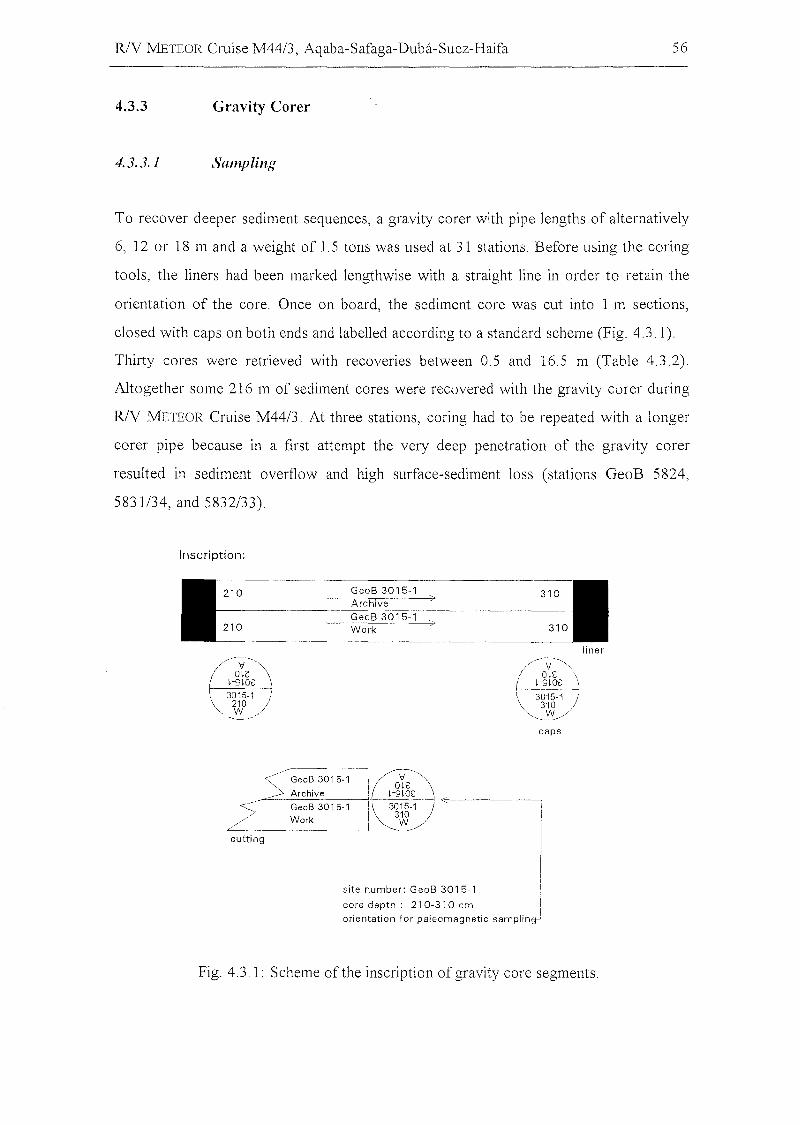
R/V METEOR Cruise M44/3, Aqaba-Safaga-Duba-Suez-Haifa 56
4.3.3
4.3.3.1
Gravity Corer
Sampling
To recover deeper sediment sequences, a gravity corer with pipe 1engths of a1temative1y
6, 12 or 18 m and a weight of 1.5 tons was used at 31 stations. Before using the coring
too1s, the liners had been marked 1engthwise with a straight 1ine in order to retain the
orientation of the core. Once on board, the sediment core was cut into 1 m sections,
c10sed with caps on both ends and 1abelled according to a standard scheme (Fig. 4.3.1).
Thirty cores were retrieved with recoveries between 0.5 and 16.5 m (Tab1e 4.3.2).
Altogether some 216 m of sediment cores were recovered with the gravity corer during
R/V METEOR Cruise M44/3. At three stations, coring had to be repeated with a longer
corer pipe because in a first attempt the very deep penetration of the gravity corer
resulted in sediment overflow and high surface-sediment loss (stations GeoB 5824,
5831/34, and 5832/33).
Inscription:
210
210
GeoB 3015-1Archive
GeoB 3015-1Work
310
310
<:/-'GeoB 3015-1
~ Archive<_____ GeoB 3015-1
// Work
cutting
/-v~'",
I o,s \I--. ,-S,o~ -1\ 3015-1)'" 310 /
"'-'!!/caps
Fig. 4.3.1: Scheme ofthe inscription ofgravity core segments.
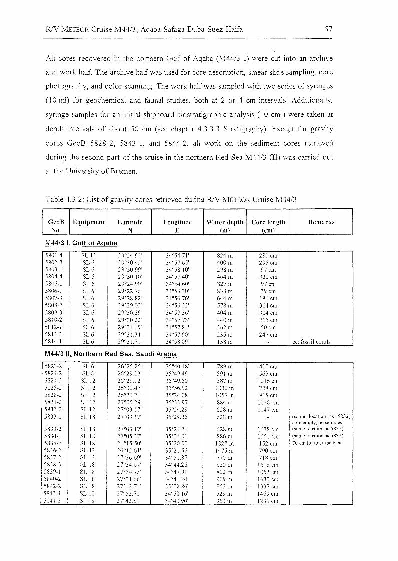
R/V METEOR Cruise M44/3, Aqaba-Safaga-Duba-Suez-Haifa 57
All cores recovered in the northern Gulf of Aqaba (M44/3 I) were cut into an archive
and work half. The archive half was used for core description, smear slide sampling, core
photography, and color scanning. The work half was sampled with two series of syringes
(10 ml) for geochemical and faunal studies, both at 2 or 4 em intervals. Additionally,
syringe sampIes for an initial shipboard biostratigraphic analysis (10 cm3) were taken at
depth intervals of about 50 cm (see chapter 4.3.3.3 Stratigraphy). Except für gravity
cores GeoB 5828-2, 5843-1, and 5844-2, all würk on the sediment cores retrieved
during the second part of the cruise in the northern Red Sea M44/3 (Il) was carried out
at the University ofBremen.
Table 4.3.2: List of gravity cores retrieved during R/V METEOR Cruise M44/3
GeoB Eqlliprnent Latitllde Longitllde Water depth Core length RernarksNo. N E (rn) (ern)
M44/3 I, Gulf of Aqaba
5801-4 SL 12 29°24.92' 34°54.71' 824 m 280 cm5802-3 SL6 29°3042' 34°57.65' 400 m 295 cm5803-1 SL 6 29°30.99' 34°58.10' 298 m 97 cm5804-4 SL 6 29°30.10' 34°5740' 464 m 330 cm5805-1 SL 6 29°24.90' 34°54.60' 827 m 97 cm5806-1 SL6 29°22.76' 34°53.30' 838 m 39cm5807-3 SL6 29°28.82' 34°56.76' 644m 186 cm5808-2 SL 6 29°29.03' 34°56.32' 578 m 364 cm5809-3 SL6 29°30.39' 34°57.36' 404 m 304 cm5810-2 SL6 29°30.22' 34°5773' 440 m 265 cm5812-1 SL 6 29°31.19' 34°57.84' 262 m 50 cm5813-2 SL6 29°31.34' 34°57.90' 235 m 247 cm5814-1 SL 6 29°31.71 ' 34°58.09' 138 m - cc: fossil corals
M44/3 11. Northern Red Sea. Saudi Arabia
5823-2 SL6 26°25.25' 35°40.18' 789 m 410 cm5824-2 SL 6 26°29.13' 35°4949' 591 m 567 cm5824-3 SL 12 26°29.12' 35°4950' 587m 1016 cm5825-2 SL 12 26°3047' 35°56.92' 1030 m 728 cm5828-2 SL 12 26°20.71' 35°2408' 1057m 915 cm5831-2 SL 12 27°05.29' 35°33.97' 884 m 1146 cm5832-2 SL 12 27°03.17' 35°24.29' 628 m 1147 cm5833-1 SL 18 27°03.17' 35°24.26' 628 m - (same location as 5832)
core empty, no sampies5833-2 SL 18 27°03.17' 35°24.26' 628 m 1638 cm (same location as 5832)
5834-1 SL 18 27°05.27' 35°34.01' 886 m 1661 cm (same location as 5831)
5835-7 SL 18 26°15.50' 35°20.00' 1328 m 152 cm 70 cm liquid, tube bent
5836-2 SL 12 26°12.61' 35°21.56' 1475 m 790 cm5837-2 SL 12 27°36.69' 34°51.87' 770 m 718 cm5838-3 SL 18 27°34.67' 34°44.26' 830 m 1618 cm5839-1 SL 18 27°34.73' 34°47.91' 802 m 1052 cm5840-2 SL 18 27°31.66' 34°41.24' 909111 1630 cm5842-2 SL 18 27°42.74' 35°0286' 863 m 1337 cm5843-1 SL 18 27°52.71' 34°58.16' 529 m 1469 cm5844-2 SL 18 27°42.81' 34°4090' 963111 1235 cm
R/V METEOR Cmise M44/3, Aqaba-Safaga-Duba-Suez-Haifa 58
4.3.3.2
4.3.3.2.1
Core Description, Smear Slide Analysis, a11(1 Color-Scanning
(H. W. Arz, T. Felis)
Methods
The core descriptions summarize the most important results of the analysis of each
sediment core following ODP convention (Graham and Mazullo, 1988). Core
descriptions for all retrieved sediment cores are shown in Figs. 4.3.2 to 4.3.28. The
"Stratigraphy" column gives the zonation defined by paleontological data (M44/3 I) and
profiling color data (M44/3 II). The lithological data, indicated in the "Lithology"
column, are based on smear slide analyses. In the structure column the intensity of
bioturbation together with individual or special features (slumps, turbidites, lamination,
shell fragments etc.) is shown. The hue and chroma attributes of color were determined
by comparison with the Munsell soil color charts and are given in the color column in the
Munsell notation.
In order to supplement the macroscopic core descriptions, a smear slide analysis was
carried out. Smear slides were taken from every described core. Altogether 225 slides
were examined using a light microscope at about 125x - 1250x magnification with cross
polarised and transmitted light. Smear slides were primarily taken from all representative
lithologies. The sediment classification is also based on ODP-nomenclature.
A Minolta CM - 2002™ hand-held spectrophotometer was used to measure percent
reflectance values of sediment color at 31 wavelength channels over the visible light
range (400-700 nm). The digital reflectance data of the spectrophotometer readings were
routinely obtained from the surface (measured in 0.5 or 1 cm steps) of the splitt cores
(archive half). In Figs.4.3.2 to 4.3.28 the color measurements of each core
representative wavelengths of 400, 550, and 700 nm, and the hue and lightness of the
sediment - are shown.
RJV METEOR Cruise M44/3, Aqaba-Safaga-Duba-Suez-Haifa 59
4.3.3.2.2 Results
Northern Gulf of Aqaba
Twelve gravity cores were retrieved along a transect c10se to the central axis of the
northern Gulf of Aqaba from water depths between 138 and 838 m (Fig. 3.2). Core
recovery was generally low (39 to 364 cm core length) because of the relatively coarse
grained sediments deposited between the morphologically steep outcropping lateral faults
which embrace the northern gulf. As tectonic activity in this area often relates to
earthquake activity, continuous sedimentation is frequently interrupted by sandy
turbidites. Generally, the sediments are a uniform brownish color containing high
amounts of terrigenous material and variable amounts of biogenie carbonate. The
sediments retrieved from below 500 m water depth (GeoB 5801-4, 5805-1, 5806-1,
5807-3, and 5808-2) much more frequent1y show erosive sand turbidites than the
shallower ones (GeoB 5802-3, 5804-4, 5809-3, and 5810-2). A proper explanation may
be the increased accumulation of turbidites in the deeper parts of the basin. The cores
from intermediate water depths (around 400 m) are mostly undisturbed. The shallow
cores (GeoB 5803-1, 5812-1, and 5813-2) are again highly disturbed because of detrital
fore-reef sedimentation and coarse sand deposits. All cores are most probab1y of
Holocene age.
Northern Red Sea, transects C, D, and E
Sixteen gravity cores were retrieved along three profiles extending from the Saudi
Arabian coast to the central axis ofthe northern Red Sea from water depths between 590
and 1060 m (Fig. 3.4). The cores are between 4.1 and 16.3 m long and consist of
alternating white to light gray foraminifer-bearing nannofossil oozes and olive gray
c1ayey nannofossil oozes to nannofossil clays. The variable amount of darker terrigenaus
material down-core strongly affects sediment color, providing an excellent tool for
stratigraphie purposes and core correlation (see chapter 4.3.3.3 Stratigraphy). The
sediments are, in general, moderately bioturbated, and except for the proximal cores
GeoB 5842-2, 5843-1, 5831-2/5834-1, and 5825-2, the gravity cores represent
undisturbed sedimentary records of the past 80 kyrs (GeoB 5823-2) to 500 kyrs (GeoB
5833-2). The carbonate concretion layer of the Last Glacial Maximum (LGM) is
RlV iVlETEOR Cruise M44/3, Aqaba-Safaga-Duba-Suez-Haifa 60
exceptionally well documented in all sediment cores. During this period sea-surface
salinity in the Red Sea probably exceeded 53%0 (Hemleben et al. 1996), resulting in an
almost complete disappearance of planktonic organisms (except for some pteropod
species) and anorganic precipitation of carbonate. Comparable concretion layers were
found in the deeper sections of the southern-transect cores GeoB 5824-3 and 5828-2,
which are obviously related to the penultimate glacial stage around 140 kyrs (OIS 6).
The cores next to the Saudi Arabian coast, cores GeoB 5842-2, 5843-1, 5831-2/5834-1,
and 5825-2, are extensively disturbed by turbidites. The admixture of detrital carbonates
in many of the turbidite sequences c1earIy reflects the proximal position to the coastal
reef platforms. Stratigraphic information far these cores is therefore very sparse.
Shaban Deep gravity cores GeoB 5835-7 and 5836-2
The two gravity cores GeoB 5835-7 and 5836-2 were retrieved from the NE basin and
SW basin of the Shaban Deep from water depths of 1328 and 1475 m, respectively. The
cores comprise of partly laminated olive gray to black brine sediments that have a very
high content of hypersaline pore water. The individual layers vary in their composition
depending on the carbonate, c1ay, and biogene silica (mainly diatoms) content. Much like
the muIticorer sampies at these stations, about the uppermost 70 cm of the sediment
cores were highly liquid and relatively hard to recover. In core GeoB 5835-7 volcanic
glass particles were occasionally found in the coarse fraction.
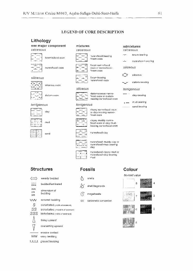
R/V J'vlETEOR Cruise M44/3, Aqaba-Safaga-Duba-Suez-Haifa 61
LEGEND OF CORE DESCRIPTION
Lithologyone major componentcalcareous
mixturescalcareous
admixturescalcareous
terrigenaus
F:::=J~ foraminiferal ooze
~~ nannofossilooze
siliceous
~0~ siliceous ooze..,-_........
[~:::~ dia tom ooze_r"
~
terrigenaus
~ TI clay
Et_~j mud
~ sand
8 '......_ ............... 1, ,
~-', ,
-+- '--t- i
-I- :
~siliceous
~.
i-'- .......f--I-- -I
nannofossil-bea ringforam ooze
foram-nannofossilooze or nannofossilforam ooze
foram-bearingnannofossilooze
diatomaceous nannofossil ooze or diatombearing nannofossil ooze
c1ayey nannofossil oozeor c1ay-bearing nannofossilooze
clayey muddy nannofossil ooze or clay-mudbearing nannofossil ooze
nannofossil clay
nannofossil muddy c1ay orna nnofossil-mud-bea ri ngc1ay
nannofossil c1ayey mud orna nnofossil-clay-be aringmud
foram-bearing
-l- nannofossil-bearing
siliceous
siliceous
diatom-bearing
terrigenaus
c1ay-bearing
mud-bearing
sand-bearing
Structures Fossils ColourMunsell vaJue
4
3
5
6 shells
1::5 shell fragments
(3' megafossils
ce earbonatie eonerelion
( ) weakly bedded
bedded/laminaled
mmdimension of
cmbedding
dm
VW seoured bedding
5 biolurbaled «30% of sediment)
55 biolurbated «30-60% of sediment)
555 bioturbated (>60% of sediment)
~ fining upward
y eoarsening upward
erosive eontact
WW wavy bedding
* $ " * graded bedding
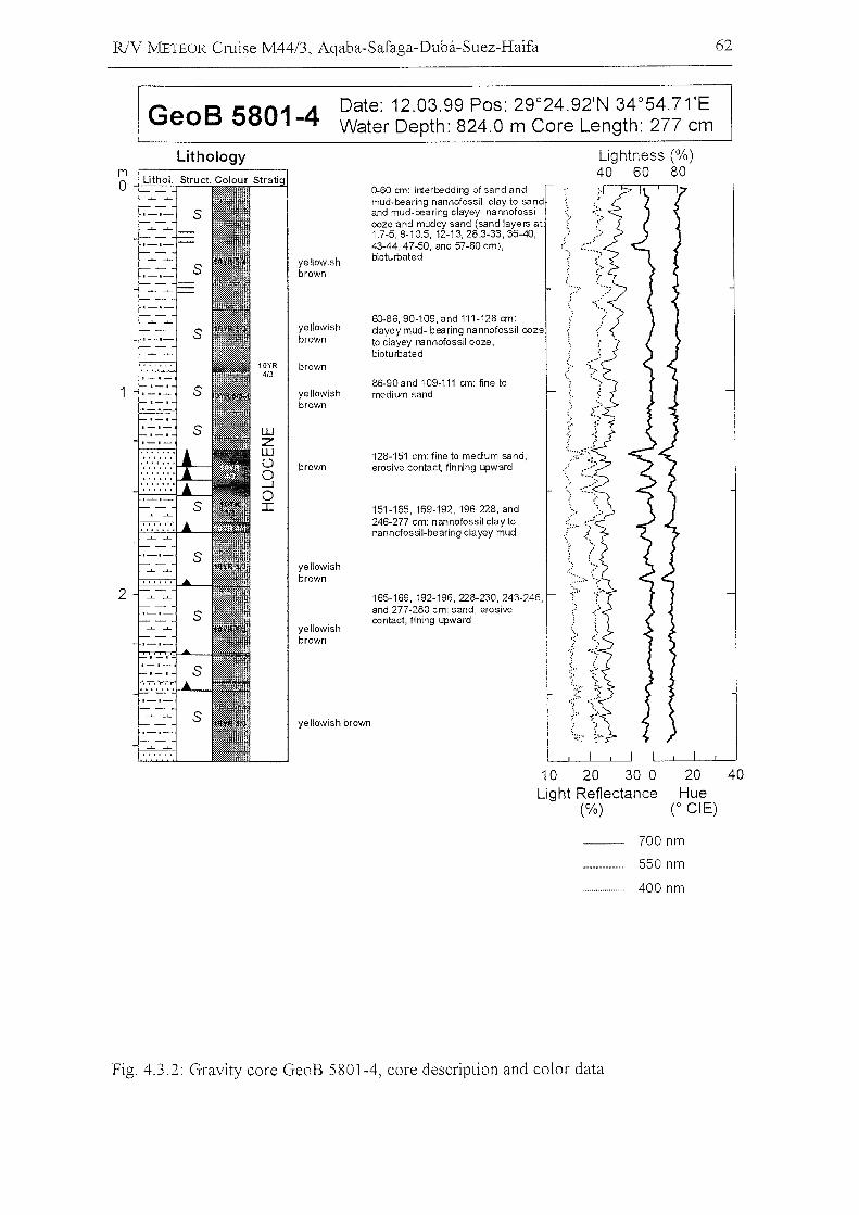
R/Y METEOR Cruise M44/3, Aqaba-Safaga-Duba-Suez-Haifa 62
GeoB 5801-4 Date: 12.03.99 Pos: 29°24.92'N 34°54.71'EWater Depth: 824.0 m Core Length: 277 cm
Lithology
yellowishbrown
yellowishbrown
10YR brown4/3
yellowishbrown
WZWÜ brown0...J0I
yellowishbrown
yellowishbrown
yellowish brown
0-60 cm: interbeddirg of sand andmud-bearing nannofossil c1ay to sandand mud-bearing clayey nannofossiooze and muddy sand (sand layers at1.7-5,8-10.5, 12-13,28.3-33,35-40, ,...43-44,47-50, and 57-60 cm), (.biotu rbated
60-86, 90-109,and 111-128 cm: ,clayey mud- bearing nannofossil oozeto clayey nannofossil ooze,bioturbated
86-90and 109-111 cm: fine tomedium sand
128-151 cm: fine to medium sand,erosive contac~ finning 4Jward
151-165, 169-192, 196-228, and246-277 cm: nannofossil clay tonannofossil-bearing clayey mud
165-169,192-196,228-230,243-246,and 277-280 cm: sand, erosivecontact, fining upward
Lightness (%)40 60 80
10 20 30 0Light Reflectance
(%)
20 40Hue
(0 eiE)
700 nm
550 nm
400 nm
Fig. 4.3.2: Gravity core GeoB 5801-4, core description and color data
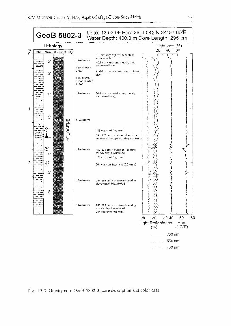
RlV METEOR Cruise M44/3, Aqaba-Safaga-Dubä-Suez-Haifa 63
GeoB 5802-3 Date: 13.03.99 Pos: 29°30,42'N 34°57.65'EWater Depth: 400.0 m Core Length: 295 cm
Lithologymo +=..:.:.=::,...::::.=::.:,..:::.=:.:..,.==~
2
olive brown
dark grayishbrown
dark grayishbrown to olivebrown
olive brown
olive brown
olive brown
olive brown
olive brown
0-4 cm: very high watercontent,extra sampIe
4-21 cm: sand· and mUd·bearingnan nofossil clay
21-26 cm: sandy muddy nannofossilclay
26-144 cm: sand-bearing muddynannofossil clay,
148 cm: shell frag ment
144-152 cm: muddy sand, erosivecontact, Iining upward, shell fragment
152-204 cm: nannofossil-bearingmuddy clay, bioturbated
171 cm: shell fragment
201 cm: coal fragment (0.5 cm 0)
204-265 cm: nannofossil·bearingclayey mud, bioturbated
265-295 cm: nannofossil-bearingmuddy clay, bioturbated284 cm: shell fragment
Lightness (%)20 40 60
I
1
1'C 20 30 40Light Reflectance
(%)
60Hue
C eiE)
700 nm
550 nm
400 nm
Fig. 4.3.3: Gravity core GeoB 5802-3, core description and color data
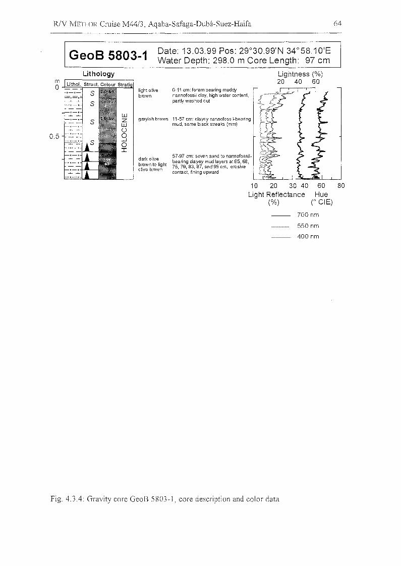
R/V J'v!ETEOR Cruise M44/3, Aqaba-Safaga-Duba-Suez-Haifa 64
GeoB 5803-1 Date: 13.03.99 Pos: 29°30.99'N 34°58.10'EWater Depth: 298.0 m Core Length: 97 cm
grayish brown 11-57 cm: c1ayey nannofossil-bearingmud, some black streaks (mm)
10 20 30 40Light Reflectance
(%)
8060Hue
CeiE)
Lightness (%)20 40 60
0-11 cm: foram bearing muddfnannofossil clay, high water content,partly washed out
57-97 cm: seven sand to nannofossilbearing c1ayey mud layers at 65,68,75, 79, 83, 87, and 95 cm, erosivecontact, fining upward
light olivebrown
dark olivebrown to lig htofive brown
LithologyLithol. Struct. Colour Stratig
mo
0.5
700 nm
550 nm
400 nm
Fig. 4.3.4: Gravity core GeoB 5803-1, core description and color data
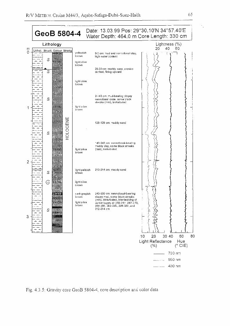
R/V METEOR Cruise M44/3, Aqaba-Safaga-Duba-Suez-Haifa 65
GeoB 5804-4 Date: 13.03.99 Pos: 29°30.10'N 34°57.40'EWater Depth: 464.0 m Core Length: 330 cm
light olivebrown
light olivebrown
Lightness (%)20 40 60
243-330 Gm: nannofossi-bearingc1ayey mud, same blaGk streaks(mm), bioturbated, interbedding ofdarker layers at: 259-261,267-270,284-286, 293-295, 299-302, and312-314 cm
143-243 Gm: nannofossi-bearingmuddy Glay, same blaGk streaks(mm), bioturbated
128-129 Gm: muddy sand
0-2 Gm: mud and nannofossil Glay,high water Gontent
dark grayishbrown
2-143 Gm: mud-bearing Glayeynannofossil ooze, same blaGkstreaks (mm), bioturbated
28-30 Gm: muddy sand, erosivecontact, fining upward
Iig ht olivebrown
light olivebrown
light olivebrown
light olivebrown
yellowishbrown
Iightyelloish 213-214 Gm: muddy sandbrown
Lithology
10 20 30 40Light Reflectance
(%)
60Hue
(0 eiE)
80
700 nm
550 nm
400 nm
Fig. 4.3.5: Gravity core GeoB 5804-4, core description and color data
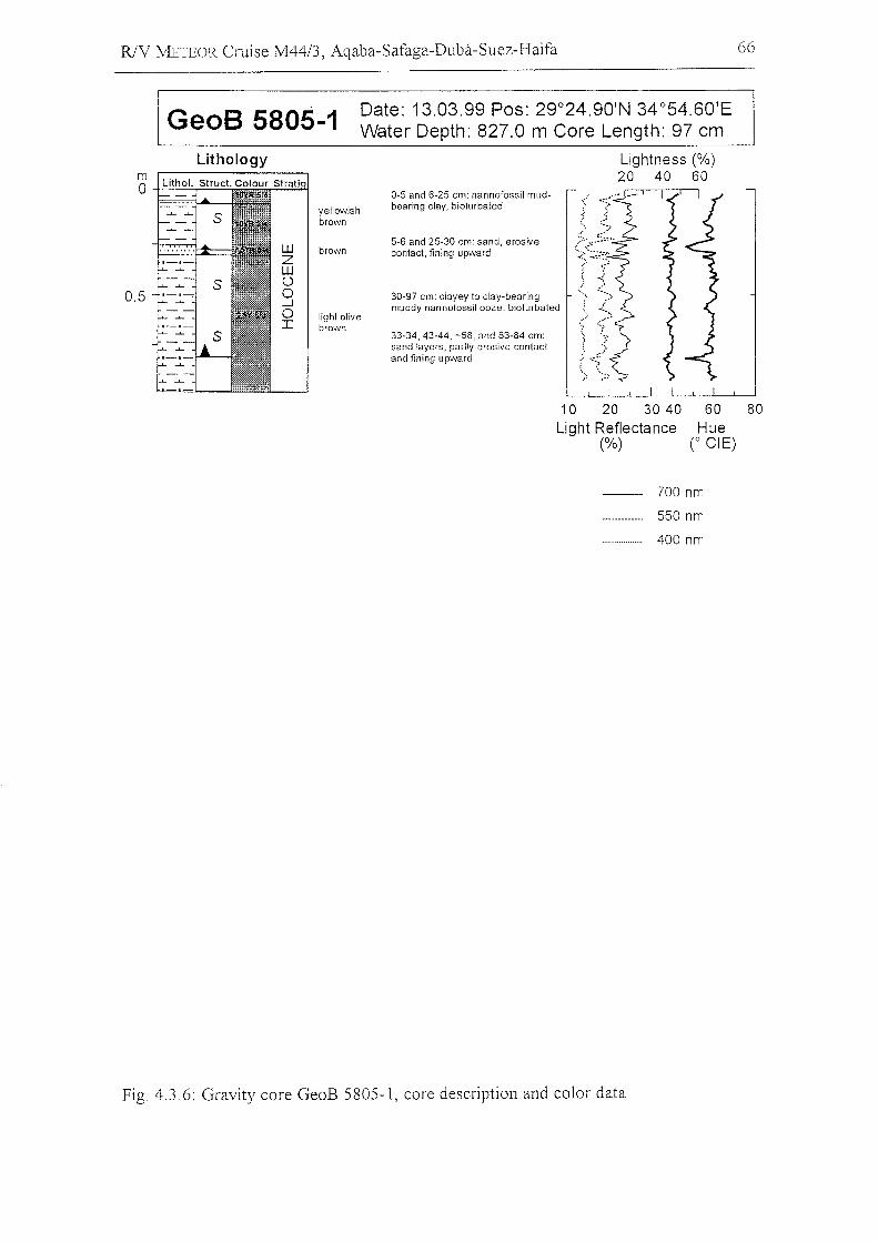
R/V METEOR Cruise M44/3, Aqaba-Safaga-Duba-Suez-Haifa 66
GeoB 5805·-1 Date: 13.03.99 Pos: 29°24.90'N 34°54.60'EWater Depth: 827.0 m Core Length: 97 cm
Lightness (%)20 40 60
Lithology
yellowishbrown
brown
light olivebrown
0-5 and 6-25 cm: nannofossil mudbearing clay, bioturbated
5-6 and 25-30 cm: sand, erosivecontact, fining upward
30-97 cm: c1ayey to c1ay-bearingmuddy nannofossil ooze, bioturbated
33-34, 43-44, -58, and 83-84 cm:sand layers, partly erosive contactand fining upward
10 20 30 40Light Reflectance
(%)
60Hue
CeiE)
80
700 nm
550 nm
400 nm
Fig. 4.3.6: Gravity core GeoB 5805-1, core description and color data
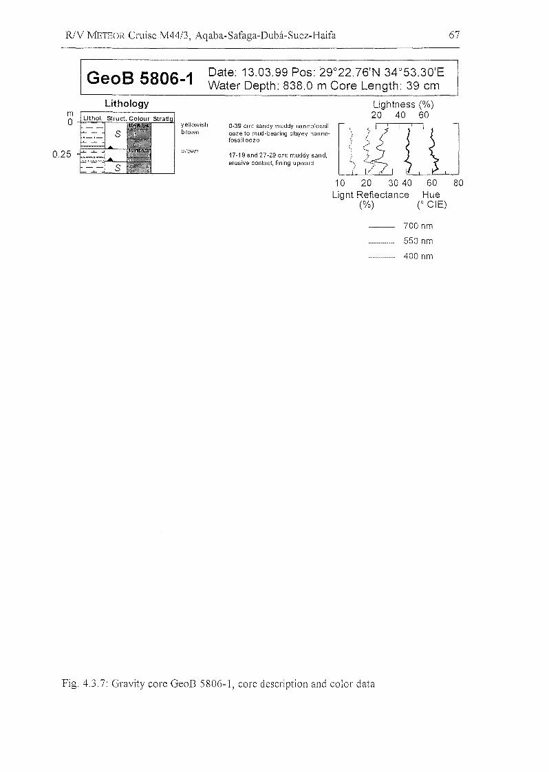
R/V METEOR Cruise M44/3, Aqaba-Safaga-Duba-Suez-Haifa 67
GeoB 5806-1 Date: 13.03.99 Pos: 29°22.76'N 34°53.30'EWater Depth: 838.0 m Core Length: 39 cm
Lithology
yellowishbrown
brown
0-39 cm: sandy muddy nannofossilooze to mud-bearing clayey nannofossilooze
17-19 and 27-29 cm: muddy sand,erosive contact, fining upNard
Lightness (%)20 40 60
llß'w10 20 30 40
Light Reflectance(%)
60Hue
(0 eiE)
80
700 nm
550 nm
400 nm
Fig. 4.3.7: Gravity core GeoB 5806-1, care description and color data
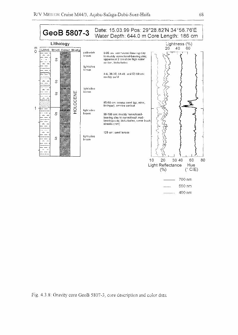
RlV METEOR Cruise M44/3, Aqaba-Safaga-Duba-Suez-Haifa 68
GeoB 5807-3 Date: 15.03.99 Pos: 29°28.82'N 34°56.76'EWater Depth: 644.0 m Core Length: 186 cm
light olivebrown
light olivebroll'Jn
8060Hue
r eiE)
Lightness (%)60
10 20 30 40Light Reflectance
(%)
0-85 cm: nannofossil-bearing clayto muddy nannofossil-bearing clay,uppermost 2 cm show high vvaterconten, bioturbated
85-98 cm: coarse sand (qz, mica,feldspar) , erosive contact
98-186 cm: muddy nannofossilbearing clay to nannofossil mudbearingcclay, bioturbated, same blackstreaks (mm)
128 cm: sand lenses
4-6, 36-38,44-45, and 57-59 cm:muddy sand
yellowishbrown
light olivebrown
light olivebrown
Lithology
700 nm
550 nm
400 nm
Fig. 4.3.8: Gravity core GeoB 5807-3, core description and color data
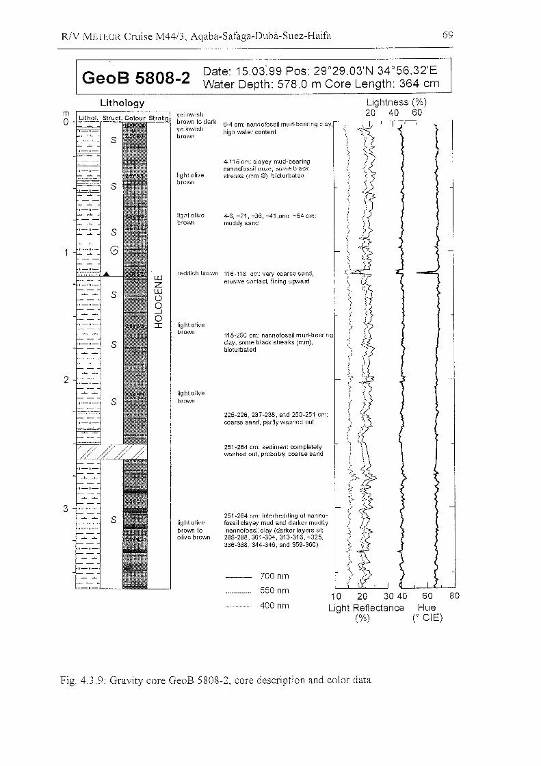
R/V IvlETEOR Cruise M4413, Aqaba-Safaga-Duba-Suez-Haifa 69
GeoB 5808-2 Date: 15.03:99 Pos: 29°29.03'N 34°56.32'EWater Depth: 578.0 m Core Length: 364 cm
8060Hue
CeiE)
Lightness (%)20 40 60
10 20 30 40Light Reflectance
(%)
700 nm
550 nm
400 nm
251-264 cm: interbedding of nanno·fossil clayey mud and darker muddynannofossil clay (darker layers at:
285-288,301·304,313·316, -325,336·338, 344-346, and 359·360)
light olivebrown 10olive brown
yellowishbrown to dark 0·4 cm: nannofossil mud·bearing clay,yellowish high water contentbrown
~.:.
4-116 cm: clayey mud-bearingnannofossil ooze, same black
light olive streaks (mm 0), bioturbatedbrown
"
light olive 4·6, -21, -36, -41 ,and -54 cm:brown muddy sand
..
":
Wreddish brown 116·118 cm: very coarse sand,
Z erosive contact, fining upvvard
WÜ .:'0 ;c
...J t0I light olive .;.
brown 118·250 cm: nannofossil mud-bearingc1ay, same black streaks (mm), I;bioturbated ;..
).
'~:'
'>light olivebrown
225·226,237-238, and 250-251 cm::~.coarse sand, partly washed out .....
251-264 cm: sediment comp\etelywashed out, probably coarse sand
2
Lithology
3
mo +=-=:.,-==
Fig. 4.3.9: Gravity core GeoB 5808-2, core description and color data
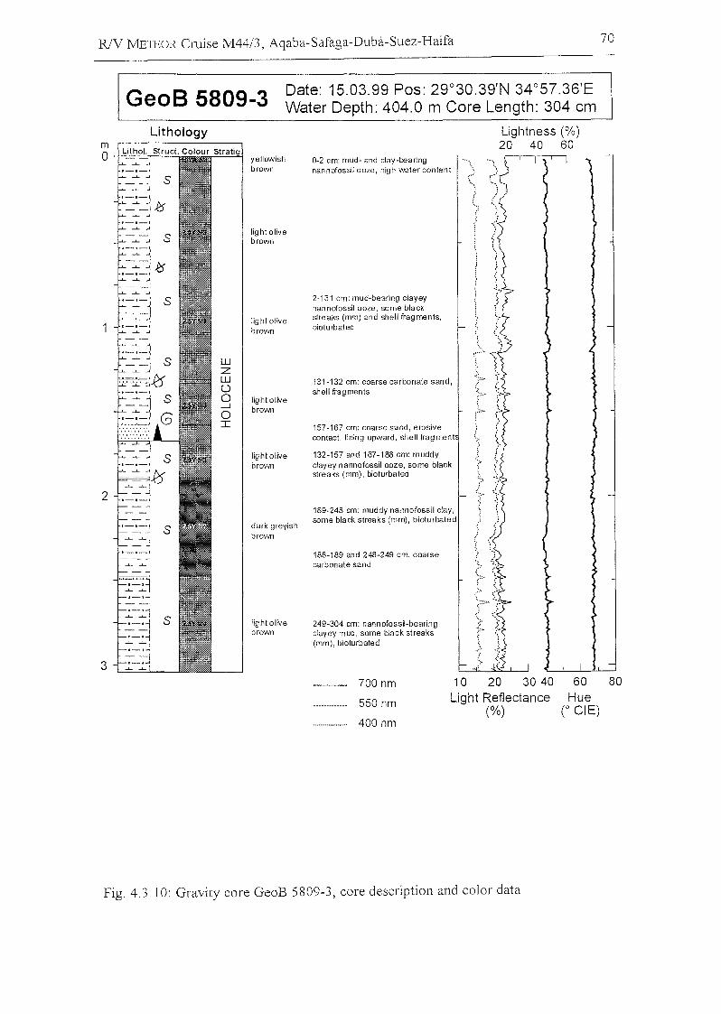
GeoB 5809-3
RlV J'vlETEOR Cruise M4413, Aqaba-Safaga-Duba-Suez-Haifa
Date: 15.03.99 Pos: 29°30.39'N 34°57.36'EWater Depth: 404.0 m Care Length: 304 cm
70
2
3
Lithology
yellowishbrown
light olivebrown
light olivebrown
light olivebrown
light olivebrown
dark greyishbrown
light olivebrown
Lightness (%)20 40 60
0-2 cm: mud- and clay-bearingnannofossil ooze, high water content
2-131 cm: mud-bearing clayeynannofossil ooze, same blackstreaks (mm) and shell fragments,bioturbated
131-132 cm: coarsecarbonate sand,shell fragments
157-167 cm: coarse sand, erosivecontact, fining upward, shell fragment
132-157 and 167-188 cm: muddyclayey nannofossil ooze, some blackstreaks (mm), bioturbated
189-248 cm: muddy nannofossil clay,same black streaks (mm), bioturbated
188-189 and 248-249 cm: coarsecarbonate sand
249-304 cm: nannofossH-bearingclayey mud, some black streaks(mm), bioturbated
700 nm
550 nm
400 nm
10 20 30 40Light Reflectance
(%)
60Hue
(0 eiE)
80
Fig. 4.3 10: Gravity core GeoB 5809-3, core description and color data
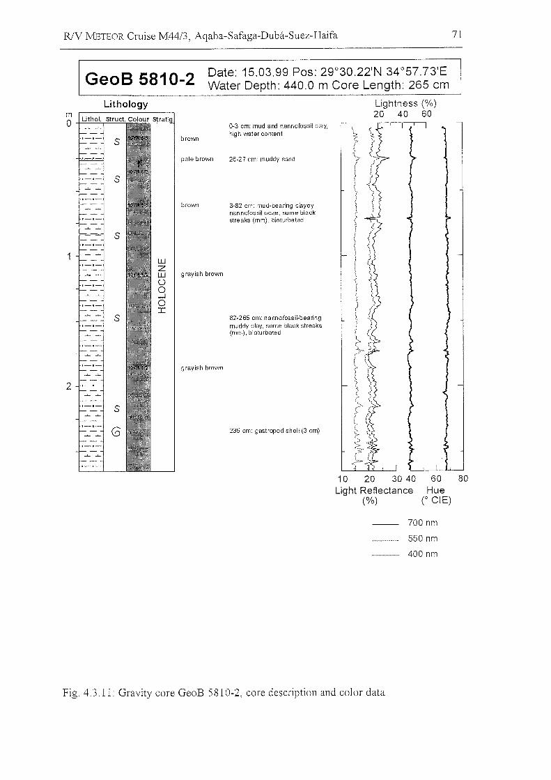
R/V METEOR Cruise M44/3, Aqaba-Safaga-Duba-Suez-Haifa 71
GeoB 5810-2 Date: 15.03.99 Pos: 29°30.22'N 34°57.73'EWater Depth: 440.0 m Core Length: 265 cm
s
8060Hue
CeiE)
~.
1f
10 20 30 40Light Reflectance
(%)
235 cm: gastropod shell (3 cm)
82-265 cm: nannofossil-beanngmuddy clay, some black streaks(mm), bioturbated
Lightness (%)20 40 60
26-27 cm: muddy sand
3-82 cm: mud-bearing cnyeynannofossil ooze, seme blackstreaks (mm), bioturbated
0-3 cm: mud and nannofossil clay,high water content
brown
brown
9 rayish brown
pale brown
wZW grayish brown()
o--loJ:
s
s
s
s
G
Lithology
2
mo +==:.,..==
700 nm
550 nm
400 nm
Fig. 4.3.11: Gravity core GeoB 5810-2, core description and color data
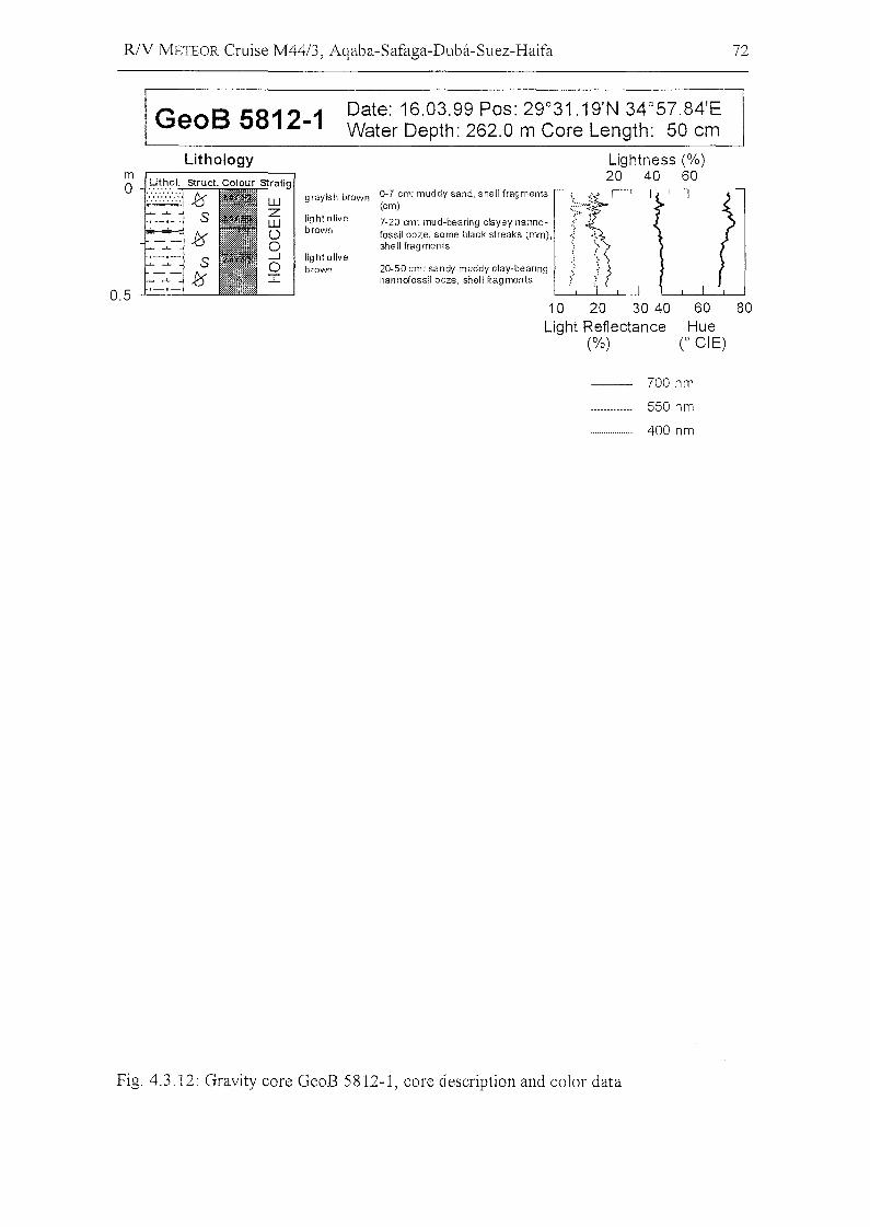
R/V METEOR Cruise M44/3, Aqaba-Safaga-Duba-Suez-Haifa 72
GeoB 5812-1 Date: 16.03.99 Pos: 29°31.19'N 34°57.84'EWater Depth: 262.0 m Core Length: 50 cm
Lightness (%)20 40 60
Lithology
0.5 --'---'---
grayish brown
light olivebrown
lig ht olivebrown
0-7 em: muddy sand, shell fragments(em)
7-20 cm: mud-bearing elayey nannofossil ooze, some blaek streaks (mm),shell fragments
20-50 em: sandy muddy elay-bearing :;nannofossil ooze, shell fragments !"
10 20 30 40Light Reftectance
(%)
60Hue
(0 eiE)
80
700 nm
550 nm
400 nm
Fig. 4.3.12: Gravity core GeoB 5812-1, core description and color data
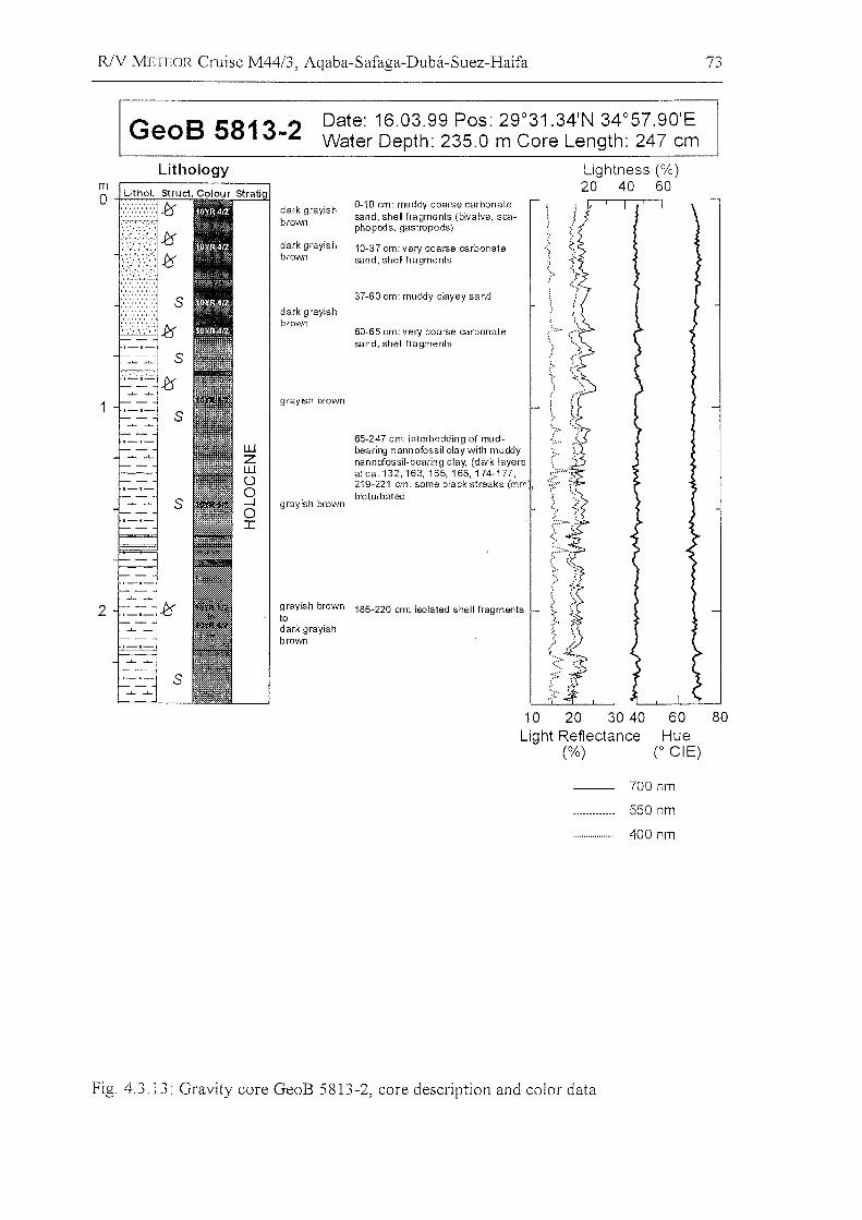
RlV METEOR Cruise M44/3, Agaba-Safaga-Duba-Suez-Haifa 73
GeoB 5813-2 Date: 16.03.99 Pos: 29°31.34'N· 34°57.90'EWater Depth: 235.0 m Core Length: 247 cm
2 ._-:_.ff
Lightness (%)20 40 60
dark grayish 0-10 cm: muddy coarse carbonatesand, shell fragments (bivalve, sca-brown phopods, gastropods)
dark grayish 10-37 cm: very coarse carbonate .,:.
brown sand, shell fragments
;>37-60 cm: muddy clayey sand
dark 9rayishbrown ..:.....60-65 cm: very coarse carbonate
sand, shell fragments
::'
9 rayish brown
:.''::.'v
65-247 cm: interbedding of mud- ......bearing nannofossil c1ay with muddy ;:.,nannofossil-bearing clay, (dark layersat ca.132, 163,165,168,174-177,219-221 cm, some black streaks (mm , ':('bioturbated
grayish brown
(:.
'.' ...'<
9rayish brown",
to185-220 cm: isolated shell fragments }dark grayish
brown .>
s
s
s
Lithology
1
10 20 30 40Light Reflectance
(%)
60Hue
(0 eiE)
80
700 nm
550 nm
400 nm
Fig. 4.3.13: Gravity core GeoB 5813-2, care description and color data
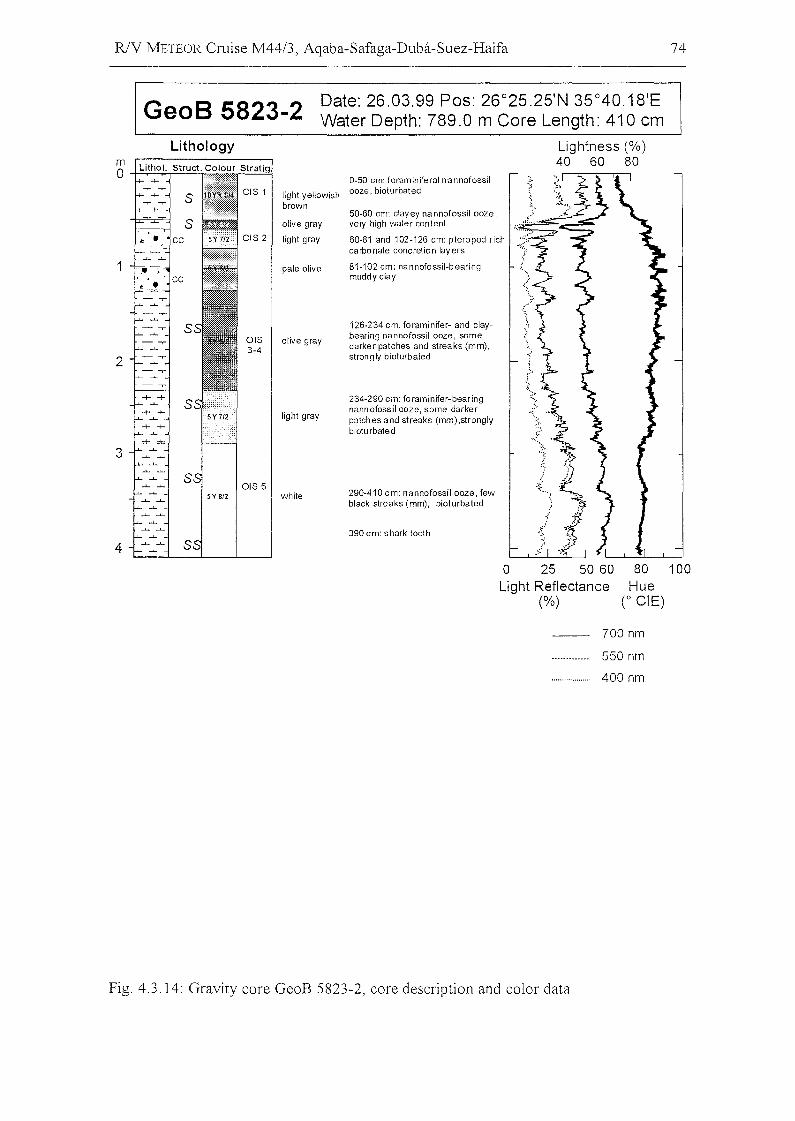
RlV METEOR Cruise M44/3, Aqaba-Safaga-Duba-Suez-Haifa 74
GeoB 5823-2 Date: 26.03.99 Pos: 26°25.25'N 35°40.18'EWater Depth: 789.0 m Core Length: 410 cm
Lig htness (%)40 60 80
.(
126-234 em: foraminifer- and elaybearing nannofossil ooze, samedarker patehes and slreaks (mm),strongly bioturbaled
81-102 em: nannofossil-bearingmuddy c1ay
50-60 em: elayey na nnofossil ooze,very high wafer content '~~:.:::===:.c::::=:::-
60-81 and 102-126 em: pteropod riehcarbonate eonerelion layers --:~;,
234-290 em: foraminifer-bearingnann ofossil ooze, same darkerpatehes and slreaks (mm),stronglybiotu rbaled
0-50 em: foraminiferal nannofossilooze, bioturbated
290-410 em: nannofossil ooze, fewblaek streaks (mm), biolurbated
390 em: shark toolh
light yellowishbrown
olive gray
light gray
pale olive
olive gray
light gray
white
Lithology
o 25 50 60Light Reflectance
(%)
80 100Hue
(0 eiE)
700 nm
550 nm
400 nm
Fig. 4.3.14: Gravity core GeoB 5823-2, core description and color data
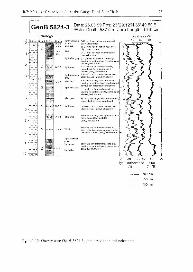
RlY METEOR Cruise M44/3, Aqaba-Safaga-Duba-Suez-Haifa 75
GeoB 5824-3 Date: 26.03.99 Pos: 26°29.12'N 35°49.50'EWater Depth: 587.0 m Core Length: 1016 cm
Lightness (%)40 60 80
509-640 cm: nannofossil ooze, lewblack streaks (mm), bioturbated
640-695 cm: clay-bearing nannofossilooze, some black nodules(mm), bioturbated
0-18 cm: foraminiferal nannofossilooze, bioturbated18-24 cm: clayey nannofossil ooze,high water oon tent
24-31 cm: pteropod rich carbonateconcretion layer
31-128 cm: foraminifer- and claybearing nannofossil ooze, some blackstreaks, bioturbated128-156 cm: foraminifer-bearlngnannofossil ooze, some blackstreaks (mm), bioturbated156-316 cm: nannofossil ooze, fewblack streaks (mm), bioturbated
316-332 cm: clay- and foraminiferbearing nannofossil ooze, bioturbated;at -328 cm ca rbonate concretions
868-1016 cm: foraminifer- and c1aybearing nannofossil ooze, some blackstreaks, bioturbated
695-868 cm: nannofossil ooze toforaminifer-bearing nannofossil ooze,lew black strea ks (mm), bioturbated
light olive gray
light gray
light brownishgray
olive gray
olive
pale olive
olive gray
light yellowishbrownolive gray
light gray
light olive gray332-497 cm: foraminifer- and clay-bearing nannofossil ooze, same blackstreaks, bioturbated
497-509 cm: clayey nannofossil ooze,same black streaks, bioturbated
light brownishgraylight gray
light olive
S 10YR 811 OIS 9 white
s
Lithology
3
2
4
6
5
8
10
10 20 30 60Light Reflectance
(%)
80 100
Hue(0 eiE)
700 nm
550 nm
400 nm
Pig. 4.3.15: Gravity core GeoB 5824-3, core description and color data
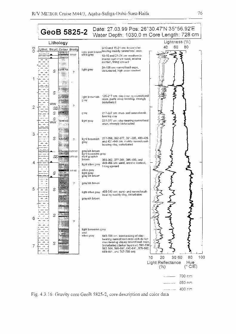
R/V METEOR Cruise M44/3, Aqaba-Safaga-Duba-Suez-Haifa 76
GeoB 5825-2 Date: 27.03.99 Pos: 26°30.4TN 35°56.92'EWater Depth: 1030.0 m Core Length: 728 cm
Lightness (%)40 60 80
24-125 cm: nannofossil ooze,bioturbated, high water content
light brownish grayandolive gray 543-728 cm: interbedding of clay
bearing nann ofossil ooze with da rkermud-bearing clayey nannofossil ooze,bioturbated (darker layers at: 565-566582-584,596-597,640-641,678-682,689-691, and 707-708 cm)
light gray
0-10 and 15-21 cm: foraminifervery pale brownbearing muddy nannofossil ooze
olive gray 10-15 and 21-24 cm: medium tocoarse carbonate sand, erosivecontact, fining upward
?
?
Lithology
Lithol. Struct. Colour Stratig'10YR713'
;;;;::~~__~_~ 5Y 512
light brownish 125-217 cm: c1ay-bearing nannofossil
gray ooze, partly wavy bedding, stronglybioturbated
2 ?
gray 217-227 cm: mud- and nannofossil-be aring c1ay
light gray 227-277 cm: clay-bearing nannofossilooze, strong Iy bioturba ted
3
'===j? light brownish 277-358,362-377,381-395,400-426,
gray and 431-449 cm: muddy nannofossil- .:.
bearing c1ay, bioturbated
grayish brownlight brown ish graydark g rayis hbrown 358-362, 377-381,395-400, and
4 ."light olive gray 449-455 cm: sand, erosive contact,
fin ing upwardolive graylight graygrayish brown
? grayish brown
5 Slight olive gray 455-543 cm: sand- and nannofossil-
bearing muddy clay, bioturbated
9 rayish brown
6
7
mo
10 20 3060Light Reflectance
(%)
80 100Hue
(0 eiE)
700 nm
550 nm
400 nmFig. 4.3.16: Gravity core GeoB 5825-2, core description and color data
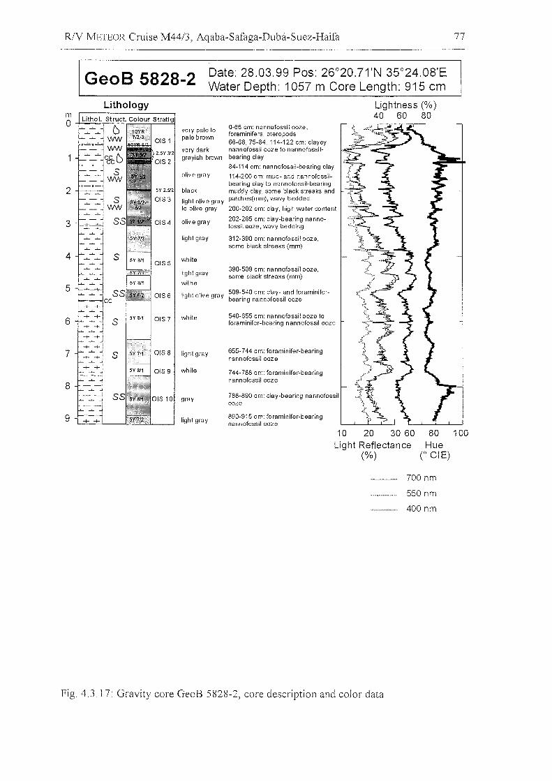
RlV METEOR Cruise M44/3, Aqaba-Safaga-Duba-Suez-Haifa 77
GeoB 5828-2 Date: 28.03.99 Pos: 26°20.71'N 35°24.08'EWater Depth: 1057 m Core Length: 915 cm
Lightness (%)40 60 80
.~
788-890 cm: ciay-bearing nannofossilooze
744-788 cm: foraminifer-bearingnann ofossil ooze
540-655 cm: nannofossil ooze toforaminifer-bearing nannofossil ooze
390-509 cm: nannofossit ooze,some black streaks (mm)
0-66 cm: nannofossil ooze,foraminifers, pteropods66-68,75-84,114-122 cm: clayeynannofossil ooze to nannofossilbearing c1ay
84-114 cm: nannofossil-bearing clay
114-200 cm: mud- and nannofossilbearing clay to nannofossil-bearingmuddy clay, some black streaks andpatches(mm), wavy bedded
200-202 cm: clay, high water content
202-285 cm: clay-bearing nannofossil ooze, wavy bedding
312-390 cm: nannofossil ooze,some black streaks (mm)
655-744 cm: foraminifer-bearingnannofossilooze
890-915 cm: foraminifer-bearingnannofossilooze
light olive gray 509-540 cm: clay- and foraminiferbearing nannofossil ooze
very pale to
0lS1pale brown
2.5Y 3/2very dark
0lS2grayish bmwn
olive gray
5Y 2.512 black
0lS3 light olive grayto olive gray
OIS 4 olive gray
light gray
OIS 5white
light gray
withe
0lS6
OIS 7 white
0lS8 light gray
OIS 9 white
gray
light gray
2
Lithology
4
3
6
mOi--..-..........~,,;;,;:,;.r=...::.=:.2j
5
8
7
9
10 20 30 60Light Reflectance
(%)
80 100Hue
CeiE)
700 nm
550 nm
400 nm
Fig 4.3.17: Gravity core GeoB 5828-2, core description and color data
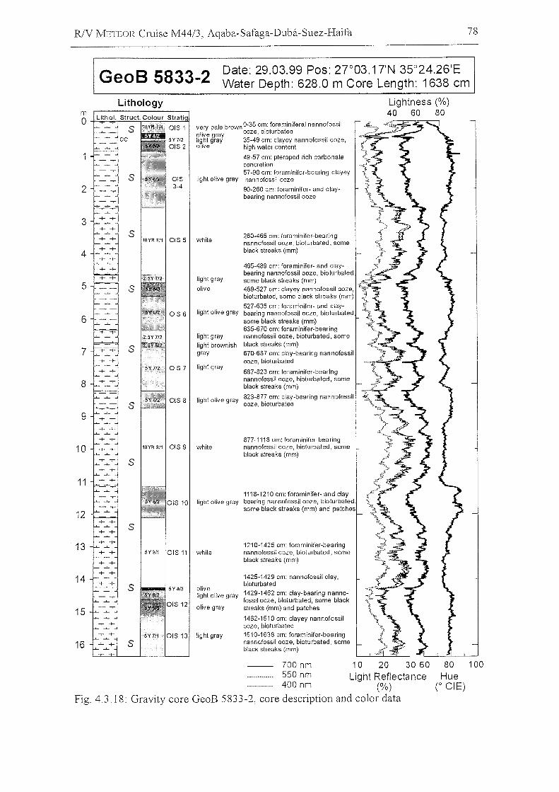
R/V METEOR Cruise M44/3, Aqaba-Safaga-Duba-Suez-Haifa 78
GeoB 5833-2 Date: 29.03.99 Pos: 27°03.17'N 35°24.26'EWater Depth: 628.0 m Care Length: 1638 cm
10YR 8/1 OIS 9 white
Lightness (%)40 60 80
260-465 em: foraminifer-bearingnannofossil ooze, bioturbated, someblack streaks (mm)
.{;
'1~".1::.,~'.
"~
40065-489 cm: fOframilnifer- abnd telabY- d _"'_,'::~
anng nanno OSSI ooze, 10 ur ate ..some black streaks (mm) ~ ...$489-527 cm: clayey nannofossil ooze, ..(~bioturbated, some black strea ks (mm) :.;',t527-635 cm: foraminifer- and claybearing nannofossil ooze, bioturbated, "' ..~
some black streaks (mm) ::~,..'.635-670 cm: foraminifer-bearingnannofossil ooze, bioturbated, someblack streaks (mm)670-687 em: clay-bearing nannofossilooze, bioturbated
687-823 cm: foraminifer-bearingnannofossil ooze, bioturbated, someblack streaks (mm)
823-877 em: clay-bearing nannofossilooze, bioturbated
1210-1425 cm: foraminifer-bearingnannofossil ooze, bioturbated, someblaek streaks (mm)
877-1118 cm: foraminifer-bearingnannofossil ooze, bioturbated, someblack streaks (mm)
1425-1429 cm: nannofossil elay,bioturbated1429-1462 cm: clay-bearing nannofossil ooze, bioturbated, some blackstreaks (mm) and patehes
1462-1510 em: elayey nannofossilooze. bioturbated1510-1638 cm: foraminifer-bearingnannofossil ooze, bioturbated, someblack streaks (mm)
1118-1210 cm: foraminifer- and ciaylight olive gray bearing nannofossil ooze, bioturbated
some blaek streaks (mm) and patehes
white
white
olivelight olive gray
olive gray
light gray
very pale brown 0-35 crJ.l: foraminiferal nannofossilolive gray ooze, bloturbatedlight gray 35-49 cm: clayey nannofossil ooze,olive high water content
49-57 cm: pteropod rieh earbo nateeoneretion57-90 em: foraminifer-bearing elayey
light olive gray nannofossil ooze
90-260 cm: foraminifer- and claybearing nannofossil ooze
light gray
olive
OIS 6 light olive gray
light gray
light brownishgray
OIS 7 light gray
OIS 8 light olive gray
OIS 115Y8/1
10YR 8/1 OIS 5
s
s
s
s
s
s
Lithology
3
4
6
2
5
9
7
8
mo
11
12
10
13
14
16
15
700 nm 10 20 30 60550 nm Light Reflectance400 nm (%)
Fig. 4.3.18: Gravity core GeoB 5833-2, core description and color data
80 100Hue
C eiE)
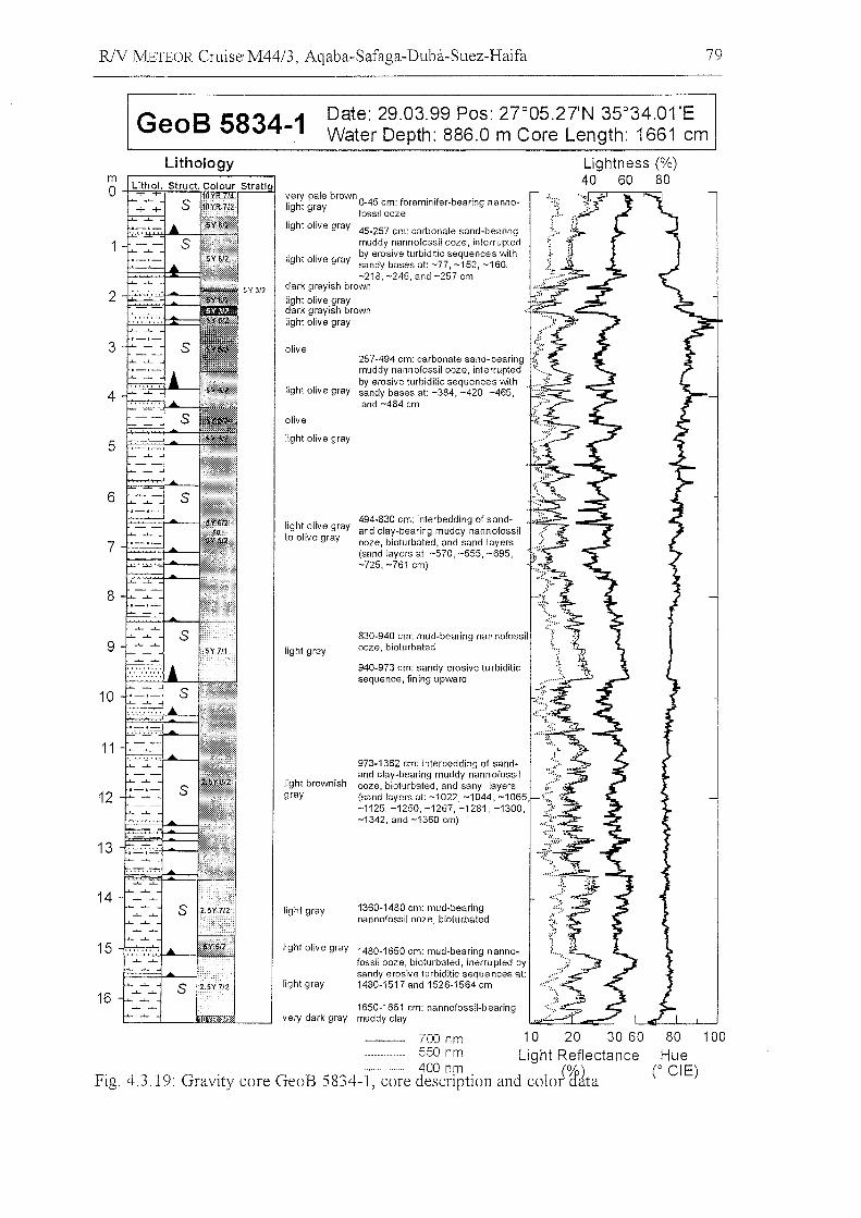
R1V J\!IETEOR Cruise M44/3, Aqaba-Safaga-Duba-Suez-Haifa 79
GeoB 5834-1 Date: 29.03.99 Pos: 27°05.27'N 35°34.01 'EWater Depth: 886.0 m Core Length: 1661 cm
Lightness (%)40 60 80
1650-1661 cm: nannofossil-bearingvery dark gray muddy clay
Lithologym0 very pale brown . . .
light gray 0-45. cm: foramlnlfer-beanng nanno- ~'.;~;
"foss.looze 1':"
light olive gray 45-257 cm: carbonate sand-bearingmuddy nannofossil ooze, interrupted
light olive grayby erosive turbiditic sequences withsandy bases at: -77, -152, -160,-218, -246, and -257 cm
2dark grayish brown
light olive graydark grayish brownlight olive gray
3 olive257-494 cm: carbonate sand-bearingmuddy nannofossil ooze, interrupted
light olive grayby erosive turbiditic sequences with
4 sandy bases at: -384, -420, -465,and -484 cm
olive
5 light olive gray
6
light olive gray494-830 cm: interbedding of sand-and clay-bearing muddy nannofossil
7to olive gray ooze, bioturbated, and sand layers
(sand layers at: -570, -655, -695,-725, -761 cm)
8
9830-940 cm: mud-bearing nan nofossil
light gray ooze, bioturbated
940-973 cm: sandy erosive tu rbiditicsequence, fining upward
10
11973-1362 cm: interbedding of sand-
light brownishand clay-bearing muddy nannofossilooze, bioturbated, and sany layers
12 gray (sand layers at: -1022, -1044, -1065-1125,-1250,-1267,-1281, -1300,-1342, and -1360 cm)
13
14light gray 1360-1480 cm: mud-bearing
nannofossil ooze, bioturbated
15 light olive gray 1480·1650 cm: mud-bearing nanno-fossil ooze, bioturbated, inerru pted bysandy erosive turbiditic sequences at:
light gray 1480-1517 and 1526-1564 cm
16
700 nm 10 20 30 60.._.._....... 550 nm Light Reflectance
Fig. 4.3.19: Gravity core GeoB 5834-1, '~~~e J~~c~~tion and color~ita
80 100Hue
(0 eiE)
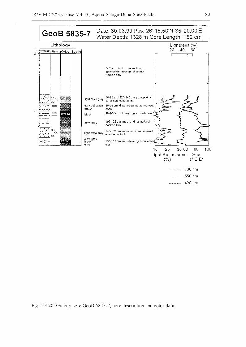
RlV METEOR Cruise M44/3, Aqaba-Safaga-Duba-Suez-Haifa 80
GeoB 5835-7 Date: 30.03.99 Pos: 26°15.50'N 35°20.00'EWater Depth: 1328 m Care Length: 152 cm
Lithology
mO~~~~~ Stratig
Lightness (%)20 40 60
0-70 em: liquid eore seetion,ineomplele recovery of eoarsefraetion only
140-153 em: medium 10 coarse sand,light olive gray erosive eonlael
107-126 em: mud- and nannofossilbearing c1ay
153-157 em: mud-bearing nannofossic1ay '---"--'
light olive gray 70-86 and 126-140 em: pteropod richcarbo nale eonerellon s
dark yellowish 86-98 em: dialorn-bearing nannofossif :.....brown ooze
blaek 98-107 em: elayey nannofossil ooze .~
olive gray
olive grayblaekolive
.' ,~. 0. ce; ,.. " ~ ce.•...... ce
10 20 30 60Light Reflectance
(%)
80 100Hue
r eiE)
700 nm
550 nm
400 nm
Fig. 4.3.20: Gravity core GeoB 5835-7, core description and color data
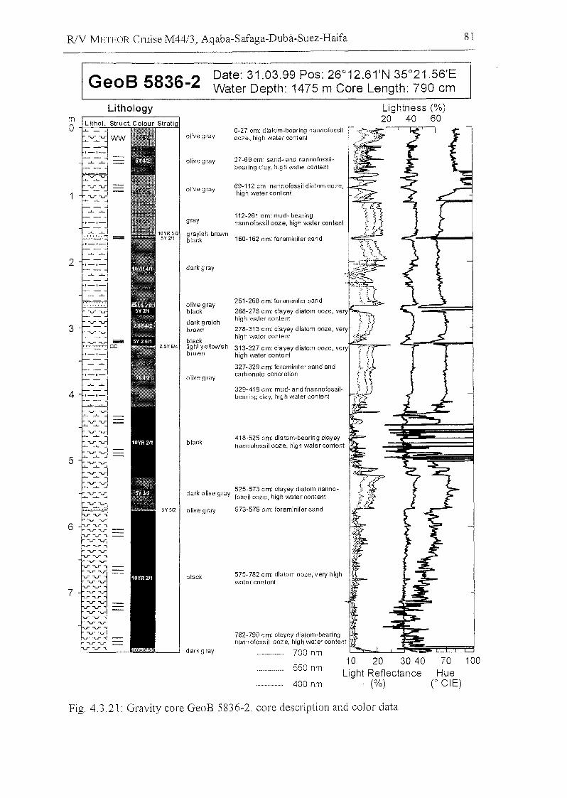
R/V METEOR Cruise M44/3, Aqaba-Safaga-Duba-Suez-Haifa 81
GeoB 5836-2 Date: 31.03.99 Pos: 26°12.61'N 35°21.56'EWater Depth: 1475 m Care Length: 790 cm
grayish brownblack 160-162 cm: foraminifer sand
blaGk 575- 782 cm: diatom ooze, very highwater content
Lightness (%)20 40 60
573-575 cm: foraminifer sand
329-418 em: mud- and fnannofossilbearing elay, high water eontent
418-525 em: diatom-bearing c1ayeynannofossil ooze, high water content
782- 790 em: Glayey diatom-bearingnannofossil ooze, high water content
700 nm ~=L.L...'::~~rr::EB::j
261-268 Gm: foraminifer sand
268-278 Gm: clayey diatom ooze, very •high water Gontent
278-313 Gm: clayey diatom ooze, veryhigh water content
313-327 cm: clayey diatom ooze, veryhigh water conte nt
327-329 em: foraminifer sand andcarbonate coneretlon
27-69 cm: sand- and nannofossilbearing clay, high water content
112-261 cm: mud- bearingnannofossil ooze, high water content
69-112 cm: nannofossil diatom ooze,high water content
0-27 cm: diatom-bearing nannofossilooze, high water content
olive gray
black
dark olive gray 525-573 em: clayey diatom nannofossil ooze, high water eontent
olive gray
olive grayblack
dark graishbrown
blacklight yellowishbrown
olive gray
gray
dark gray
olive gray
olive gray
dark gray
Lithology
2
4
3
mo
5
6
7
550 nm
400 nm
10 20 30 40Light Reflectance
(%)
70 100Hue
(0 CI E)
Fig, 4.3,21: Gravity core GeoB 5836-2, core description and color data
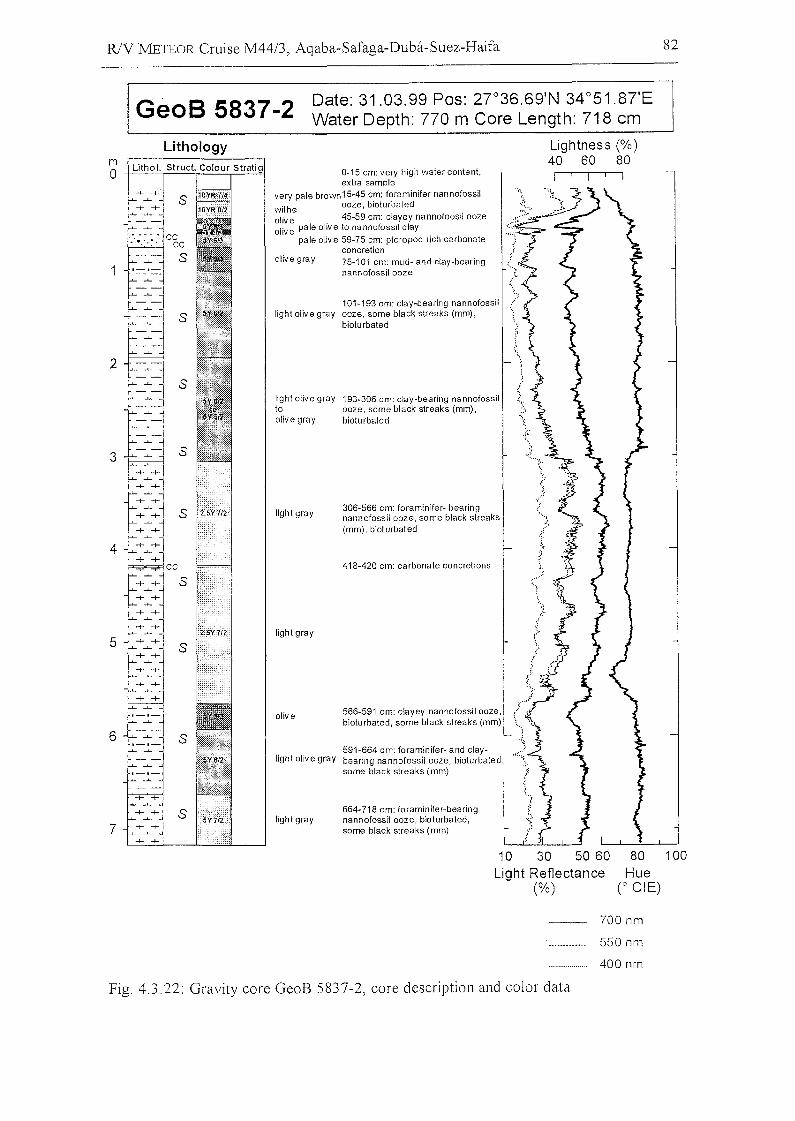
R/Y METEOR Cruise M44/3, Aqaba-Safaga-Duba-Suez-Haifa 82
GeoB 5837-2 Date: 31.03.99 Pos: 27°36.69'N 34°51.87'EWater Depth: 770 m Core Length: 718 cm
101-193 cm: clay-bearing nannofossillight olive gray ooze, same black streaks (mm) ,
bioturbated
light olive gray 193-306 cm: clay-bearing nannofossilto ooze, same black streaks (mm) ,olive gray bioturbated
Lightness (%)40 60 80
566-591 cm: clayey nannofossil ooze,bioturbated, some black streaks (mm)
418-420 cm: carbonate concretions
664-718 cm: foraminifer-bearingnannofossil ooze, bioturbated,same black streaks (mm)
306-566 cm: foraminifer- bearingnannofossil ooze, same black streaks(mm), bioturbated
olive
591-664 cm: foraminifer- and claylight olive gray bearing nannofossil ooze, bioturbated,
same black streaks (mm)
light gray
light gray
Iighl gray
0-15 cm: very high water conte nl ,extra sampie
very pale brown15-45 cm: foraminifer nannofossilwithe ooze, bioturbatedolive 45-59 cm: clayey nannofoosil oozeolive pale olive to nannofossil clay
pale olive 59-75 cm: pteropod rich carbonateconcrelion
olive gray 75-101 cm: mud- and clay-bearingnannofossil ooze
s
Lithology
2
4
3
7
5
6
mo
10 30 50 60Light Reflectance
(%)
80 100Hue
(0 eiE)
700 nm
550 nm
400 nm
Fig. 4.3.22: Gravity core GeoB 5837-2, core description and color data
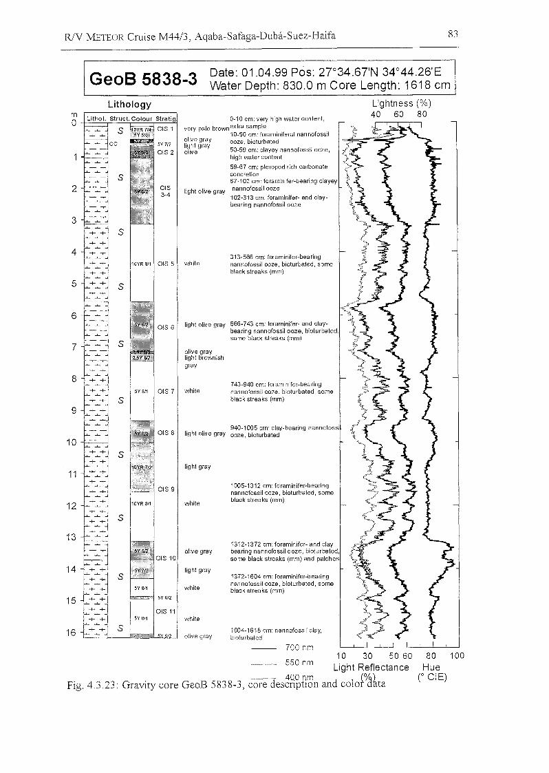
R/V METEOR Cruise M44/3, Aqaba-Safaga-Duba-Suez-Haifa 83
GeoB 5838-3 Date: 01.04.99 Pos: 27°34.67'N 34°44.26'EWater Depth: 830.0 m Care Length: 1618 cm
80 100
HueC eiE)
Lightness (%)40 60 80
550 nm
700 nm
1372-1604 cm: foraminifer-bearingnannofossil ooze, bioturbated, someblack streaks (mm)
1604-1618 cm: nannofossil clay,biotu rbated
1312-1372 cm: foraminifer- and c1aybearing nannofossil ooze, bioturbated,sonne black streaks (mm) and patches
313-566 cm: foraminifer-bearingnannofossil ooze, bioturbated, someblack streaks (mm)
0-10 cm: very high watercontent,very pale brownextra sampie
10-50 cm: foraminiferal nannofossilolive gray ooze bioturbaledlight gray ,olive 50-59 cm: clayey nannofossil ooze,
high water content
59-67 cm: pteropod rich carbonateconcretion67-102 cm: foraminifer-bearing clayey
light olive gray nannofossilooze102-313 cm: foraminifer- and c1aybearing nannofossil ooze
ais3-4
SY 7/2
ais 2
10YR 8/1 OIS 5 white
OIS 6 light olive gray 566-743 cm: foraminifer- and c1ay-bearing nannofossil ooze, bioturbated,
Ssonne black streaks (mm)
olive graylight brownishgray
743-940 cm: foraminifer-bea ringSY 8/1 ais 7 white nan nofossil ooze, bioturbated, some
S black streaks (mm)
ais 8 light olive gray940-1005 cm: clay-bearing nannofossiooze, bioturbated
light gray
ais 91005-1312 cm: foraminifer-bearingnannofossil ooze, bioturbated, some
10YR 811 whiteblack slreaks (mm)
S
olive gray
Slight gray
white
SY 6/2
ais 11SY811 white
Solive gray
s
Lithology
3
9
8
5
7
2
4
6
mo
11
10 30 50 60
Light Reflectance
Fig. 4.3.23: Gravity core GeoB 583 8-3, co're"des~~i~n~n and color~~ta
12
10
14
13
15
16
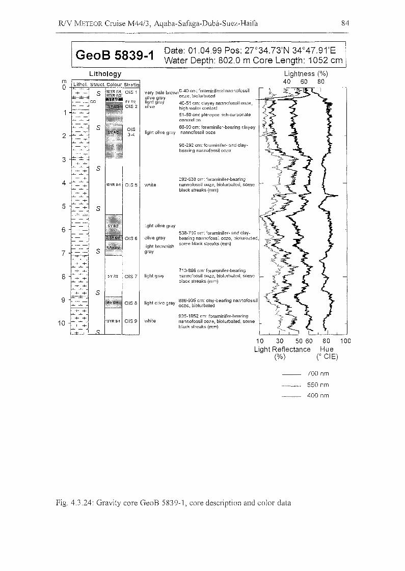
R/V METEOR Cruise M44/3, Aqaba-Safaga-Duba-Suez-Haifa 84
GeoB 5839-1 Date: 01.04.99 Pos: 27°34.73'N 34°47.91'EWater Depth: 802.0 m Core Length: 1052 cm
Lightness (%)40 60 80
90-292 em: foraminifer- and claybearing nannofossil ooze
935-1052 cm: foraminifer-bearingnannofossil ooze, bioturbated, someblack streaks (mm)
very pale brown O-40 cm: foraminiferal nannofossilolive gray ooze, bloturbatedlight gray 40-51 cm: clayey nannofossil ooze,olive high water eontent
51-60 cm: pteropod rieh carbonateconeretion
60-90 cm: foraminifer-bearing clayeylight olive gray nannofossil ooze
white
S
292-538 em: foraminifer-bearing10YR 8/1 OIS 5 white nannofossil ooze, bioturbated, some
blaek streaks (mm)
S
light olive gray
538-710 cm: foraminifer- and elay-OIS 6 olive gray bearing nannofossil ooze, bioturbated,
light brownishsome black streaks (mm)
S gray
710-886 cm: foraminifer-bearing5Y 712 OIS 7 light gray nannofossil ooze, bioturbated, some
black streaks (mm)
OIS 8 light olive gray 886-935 em: clay-bearing nannofossilooze, bioturbated
Lithology
4
3
2
mo
5
8
7
6
9
10
10 30 50 60Light Reflectance
(%)
80 100Hue
(0 CI E)
700 nm
550 nm
400 nm
Fig. 4.3.24: Gravity core GeoB 5839-1, core description and color data
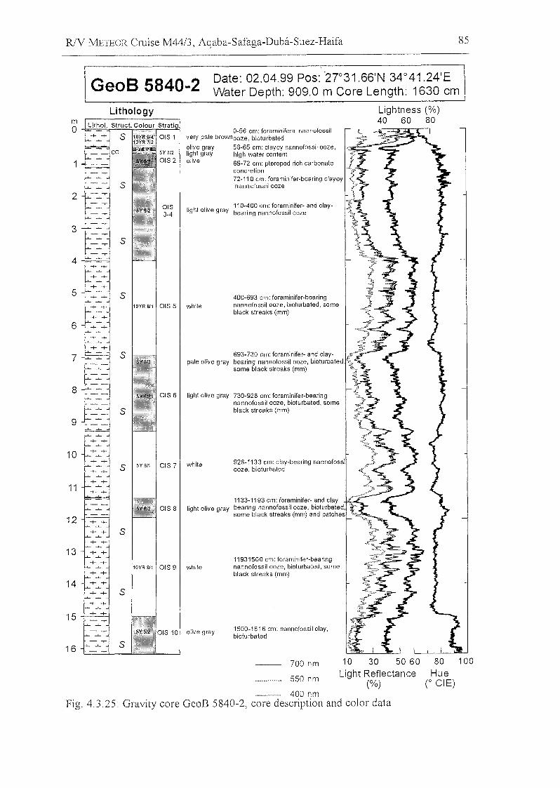
R/Y METEOR Cruise M44/3, Aqaba-Safaga-Duba-Suez-Haifa 85
GeoB 5840-2 Date: 02.04.99 Pos: ·2r31.66'N 34°41.24'EWater Depth: 909.0 m Care Length: 1630 cm
80 100
HueC eiE)
Lightness (%)40 60 80
10 30 50 60
Light Reflectance(%)
700 nm
550 nm
928-1133 cm: clay-bearing nannofossiooze, bioturbated
1133-1193 cm: foraminifer- and clay ,( .bearing nannofossil ooze, bioturbated, 4:some black streaks (mm) and patches ""'"
':'·i"·:6~
.:';:~
';:~~~":';"
~1::-
t-11931500 cm: foraminifer-bearingnannofossil ooze, bioturbated, someblack streaks (mm)
56-65 cm: c1ayey nannofossil ooze,high water content
65-72 cm: pteropod rich carbonatecone retion jl-i
72-110 cm: foraminifer-bearing clayey <:nann ofossil ooze ~;<."r
l~
1500-1616 cm: nannofossil ciay,bioturbated
400-693 cm: foraminifer-bearingnannofossil ooze, bioturbated, someblack streaks (mm)
110-400 cm: foraminifer- and claylight olive gray bearing nannofossil ooze
light olive gray
white
olive gray
693-730 cm: foraminifer- and clay- " ..0-
pale olive gray bearing nannofossil ooze, bioturbated, .;,.,.some black streaks (mm) ~i" ...
",h' ,IW, ,my 730-'28 '"' f,,,m'"',,-""'"' \,nannofossil ooze, bioturbated, some "black streaks (mm) ;~: .
olive graylight grayolive
0-56 cm: foraminiferal nannofossilvery pale brownooze, bioturbated
ais 8
ais 6
10YR 8/1 ais 5 white
10YR 8/1 ais 9
S 5Y811 ais 7 white
s
s
s
s
s
8
4
6
7
9
3
5
Lithologym0
-t- -t- S
1
S2
11
10
13
12
15
14
16
400 nmFig. 4.3.25: Gravity core GeoB 5840-2, core description and color data
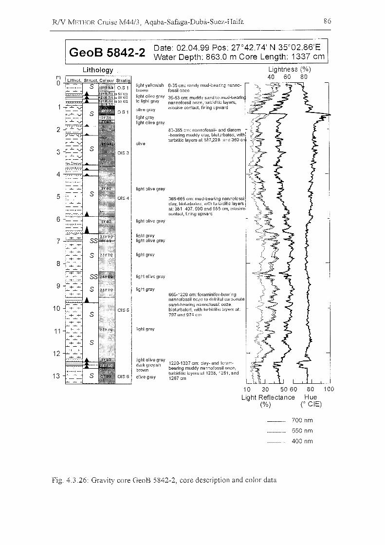
RlV METEOR Cruise M44/3, Aqaba-Safaga-Duba-Suez-Haifa 86
GeoB 5842-2 Date: 02.04.99 Pos: 27 0 42.74' N 35°02.86'EWater Depth: 863.0 m Care Length: 1337 cm
light olive graydark greyish 1220-1337 cm: clay- and foram-brown bearing muddy nannofossil ooze,
turbiditic layers at 1238, 1251, andolive gray 1267 cm
Lithology
2
3
4 -{:u:;:=!-.o--
5
6
8
9
10
11
12
13
light yellowishbrownlight olive grayto light gray
olive gray
light graylight olive gray
olive
light olive gray
light olive gray
light graylight olive gray
light gray
light olive gray
light gray
light gray
0-35 cm: sandy mud-bearing nannofossilooze
35-83 cm: muddy sand to mud-bearinnannofossil ooze, turbiditic layers,erosive contact, fining upward
83-365 cm: nan nofossil- and diatom-bearing muddy c1ay, bioturbated, withturbititic layers at 187,228 and 360 c
365-665 cm: mud-bearing nannofossilc1ay, bioturbated, with tu rbiditic layersat: 381,407,590 and 665 cm, erosiveconfact, fining upward
665-1220 cm: foraminifer-bearingnannofossil ooze to detrital carbonatesand-bearing nannofossil ooze,bioturbated, with turbiditic layers at:797 and 974 cm
.~
Lightness (%)40 60 80
10 30 50 60Light Reflectance
(%)
80 100Hue
(0 eiE)
700 nm
550 nm
400 nm
Fig. 4.3.26: Gravity core GeoB 5842-2, core description and color data
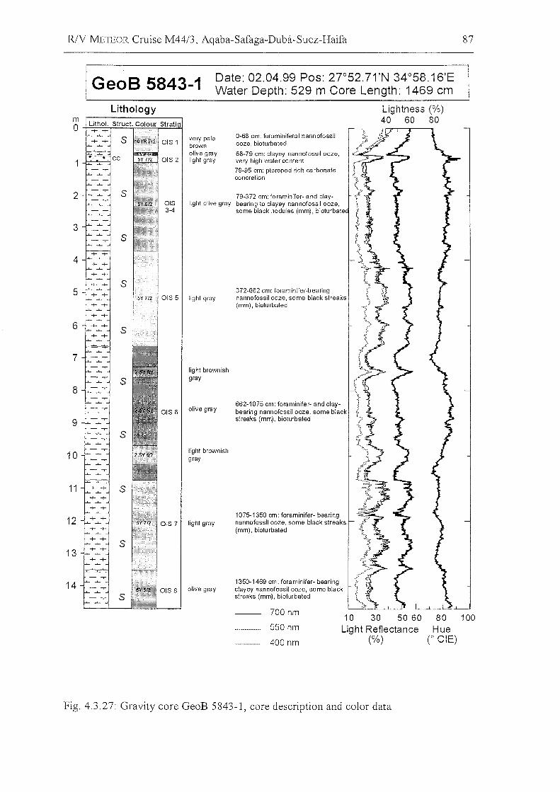
R/Y METEOR Cruise M44/3, Aqaba-Safaga-Duba-Suez-Haifa 87
GeoB 5843-1 Date: 02.04.99 Pos: 2J052.71 'N 34°58.16'EWater Depth: 529 m Core Length: 1469 cm
79-372 em: foraminifer- and claylight olive gray bearing to elayey nannofossil ooze,
some blaek nodules (mm), bioturbate
662-1075 em: foraminifer- and elaybearing nannofossil ooze, some blaekstreaks (mm), bioturbated
80 100Hue
(0 eiE)
Lightness (%)40 60 80
10 30 50 60Light Reflectance
(%)
700 nm
550 nm
400 nm
372-662 em: foraminifer-bearingnannofossil ooze, some blaek streaks(mm), bioturbated
1075-1350 cm: foraminifer- bearingnannofossil ooze, some blaek streaks(mm), bioturbated
1350-1469 cm: foraminifer- bearingclayey nannofossil ooze, some blackstreaks (mm), bioturbated
0-68 em: foraminiferal nannofossilooze, bioturbated
68-79 em: elayey nannofossil ooze,very high water eontent
79·95 em: pteropod rieh carbonateeoneretion
very palebrownolive graylight gray
light gray
light brownishgray
olive gray
light brownishgray
light gray
olive gray
2
Lithology
3
4
5
7
6
mO-t-=:;~~=':;-";:';:;';'F'T=4
8
9
11
10
12
13
14
Fig. 4.3.27: Gravity core GeoB 5843-1, core description and color data
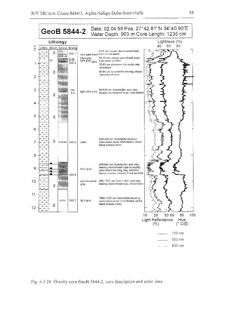
RlY METEOR Cruise M44/3, Aqaba-Safaga-Duba-Suez-Haifa 88
GeoB 5844-2 Date: 02.04.99 Pos: 27 0 42.81' N 34°40.90'EWater Depth: 963 m Care Length: 1235 cm
Lightness (%)40 60 80
543-848 em: foraminifer-bearingnannofossil ooze, bioturbated, someblaek streaks (mm)
848-950 em: foraminifer- and elaybearing nannofossil ooze to muddynannofossil-bearing c1ay, turbiditielayers, erosive eontaet, fining upward
1062-1235 em: foraminifer-bearingnannofossil ooze, bioturbated, someblaek streaks (mm)
light brownish 950-1062 em: foraminifer- and elay-gray bearing nannofossil ooze, bioturbated
94-543 em: foraminifer- and elay-light olive gray bearing nannofossil ooze, bioturbated
0-63 cm: foraminiferal nannofossilvery pale brownooze, bioturbated
olive gray 63-70 em: elayey nannofossil ooze,light gray olive high water eontent
70-80 em: pteropod rieh carbonateeoneretion
80-94 em: foraminifer-bearing elayeynannofossil ooze
olive gray
OIS 6
5Y7/2 OIS 7 light gray
S 10YR8/1 OIS 5 white
s
4
3
2
Lithology
7
5
6
8
mo~~;,,==:,..;:;.;:~~~
10
11
12
10 30 50 60Light Reflectance
(%)
80 100Hue
(0 eiE)
700 nm
550 nm
400 nm
Fig. 4.3.28: Gravity core GeoB 5844-2, core description and color data
R/V METEOR Cruise M44/3, Aqaba-Safaga-Duba-Suez-Haifa 89
4.3.3.3
4.3.3.3.1
Stratigraphy
(H. W. Arz, B. Donner, T. Lützeler)
Methods
For a preliminary shipboard biostratigraphie analysis sampIes were taken in about 50 em
intervals down eore of eaeh sediment eore from the northern Gulf of Aqaba. Sampling
depths eoineide with those for smear slide analysis. 8 to 10 ml of the sediment were
washed over a 150 1..lIn mesh sieve, dried in an oven at 60°C and finally filled into 5 ml
glass tubes. The height of the material eolumn in the glass tube was used as an indieator
for the relative sand eontent ofthe sampIes.
Normally at a latitude of 20°_30° N (Atlantie Oeean), the stratigraphieal analysis ean be
done by eounting forminifera of the Globorotalia menardii eomplex (Erieson and
Wollin, 1968). They give information about glaeial/interglaeial eycles. In the Gulf of
Aqaba foraminifera of the G. menardii eomplex are very rare, too rare to allow a
stratigraphie overview. Instead, the stratigraphie classifieation was made by determining
the abundanee of the warm-water surfaee speeies Globigerinoides rubel' and
Globigerinoides sacculifer - both appearing in the Gulf in high abundances during
warmer times.
Aceording to Reiss et al. (1980) in isotope stages 1 and 5 faun al assemblages are
representatives of present-day temperature and salinity eonditions in the Gulf of
AqabaINorthern Red Sea. Speeies of tropieal-subtropieal eharaeter, symbionts bearing
and spinose are dominant. Fine-pored, smooth and keeled forms are absent (only
southern Red Sea is Globorotalia-bearing). Pitted speeies (N pachyderma, sinistral) are
rare, but oeeurring in intervals of isotope stage 5. In isotope stages 2-4 and 6, faunal
assemblages reflect both lower temperatures and partieularly higher salinities. Amounts
of G. sacculifer deerease and G. ruher beeomes dominant. Probably winter temperatures
of <17°C in the Gulf prevent G. saccultfer from surviving. The temperature limit of G.
ruher seems to be about 13 oe. Finally, during the Last Glaeial Maximum planktonie
foraminifera are absent due to high salinities exeeeding 50%0 (aplanktic zone). On the
basis of the G. ruber/(G. rubel' + G. sacculifer) index and especially the identification of
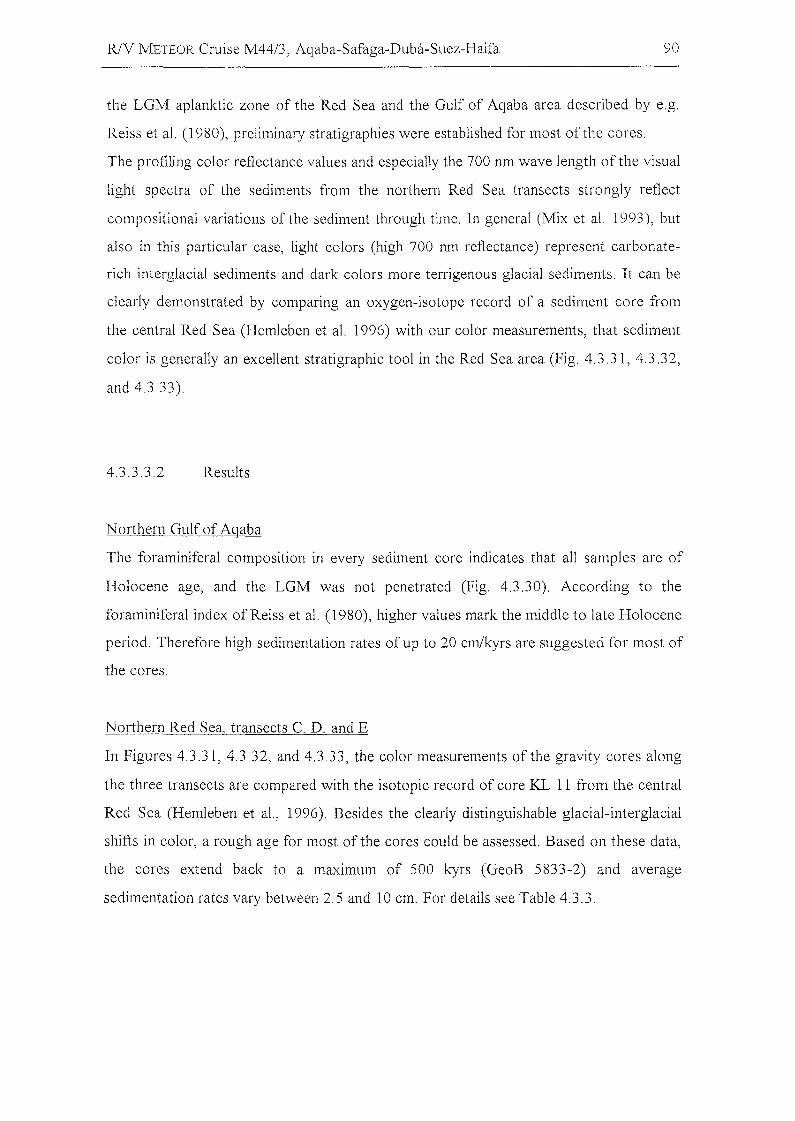
RlV J'vlETEOR Cruise M44/3, Aqaba-Safaga-Duba-Suez-Haifa 90
the LGM aplanktic zone of the Red Sea and the Gulf of Aqaba area described by e.g.
Reiss et aI. (1980), preliminary stratigraphies were established for most of the cores.
The profiling color reflectance values and especially the 700 nm wave length of the visual
light spectra of the sediments from the northern Red Sea transects strongly reflect
compositional variations of the sediment through time. In general (Mix et aI. 1993), but
also in this particular case, light colors (high 700 nm reflectance) represent carbonate
rich interglacial sediments and dark colors more terrigenous glacial sediments. It can be
cIearly demonstrated by comparing an oxygen-isotope record of a sediment core from
the central Red Sea (Hemleben et aI. 1996) with our color measurements, that sediment
color is generally an excellent stratigraphie tool in the Red Sea area (Fig. 4.3.31, 4.3.32,
and 4.3.33).
4.3.3.3.2 Results
Northern Gulf of Aqaba
The foraminiferal composition in every sediment core indicates that all sampIes are of
Holocene age, and the LGM was not penetrated (Fig. 4.3.30). According to the
foraminiferal index ofReiss et aI. (1980), higher values mark the middle to late Holocene
period. Therefore high sedimentation rates of up to 20 cm/kyrs are suggested for most of
the cores.
Northern Red Sea, transects C, D, and E
In Figures 4.3.31,4.3.32, and 4.3.33, the color measurements ofthe gravity cores along
the three transects are compared with the isotopic record of core KL 11 from the central
Red Sea (Hemleben et aI. , 1996). Besides the cIearly distinguishable glacial-interglacial
shifts in color, a rough age for most ofthe cores could be assessed. Based on these data,
the cores extend back to a maximum of 500 kyrs (GeoB 5833-2) and average
sedimentation rates vary between 2.5 and 10 cm. For details see Table 4.3.3.
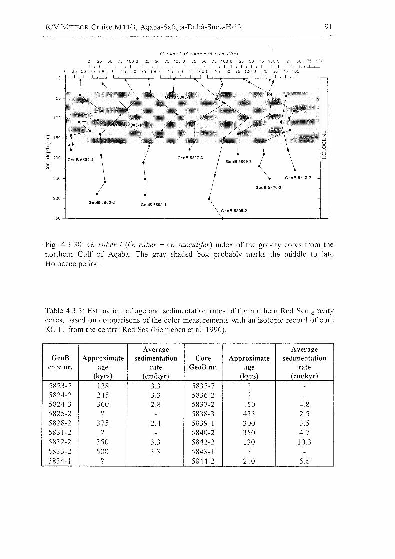
R/V METEOR Cruise M44/3, Aqaba-Safaga-Duba-Suez-Haifa 91
wzwÜo....Jo:c
GeoS 5810-2
GeoS 5808-2
GeoS 5807·3
GeoS 5804-4GeoS 5802-3
G. ruber I (G. ruber + G. sacculifer)
o 25 50 75 100 0 25 50 75 100 0 25 50 75 100 0 25 50 75 100 0 25 50 75 100I I I I I , 1 , ! I t I , I r I t I I I I , I I ! ! I 1 , 1 , I I ! , I I 1 I ! I I, I
50 75 100 0 25 50 75 1000 25 50 75 1000 25 50 75 1000 25 50 75 100! , I , I , I , I
0 25
0
50
100
E 150-S..c:Q.QJ"0 200~0
Ü
250
300
350
Fig. 4.3.30: G. rubel' / (G. rubel' + G. sacculifer) index of the gravity cares from thenorthern Gulf of Aqaba. The gray shaded box probably marks the middle to lateHolocene period.
Table 4.3.3: Estimation of age and sedimentation rates of the northern Red Sea gravitycares, based on comparisons of the color measurements with an isotopic record of coreKL 11 from the central Red Sea (Hemleben et al. 1996).
Average AverageGeoB Approximate sedimentation Core Approximate sedimentation
core nr. age rate GeoB nr. age rate(kyrs) (cm/kyr) (kyrs) (cm/kyr)
5823-2 128 3.3 5835-7 ? -5824-2 245 3.3 5836-2 ? -5824-3 360 2.8 5837-2 150 4.85825-2 ? - 5838-3 435 2.55828-2 375 2.4 5839-1 300 3.55831-2 7 - 5840-2 350 4.75832-2 350 3.3 5842-2 130 10.35833-2 500 3.3 5843-1 ? -5834-1 7 - 5844-2 210 5.6
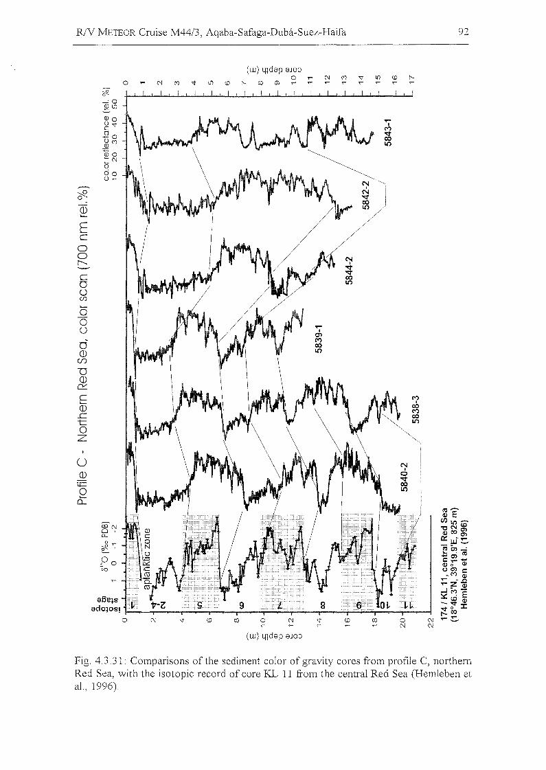
RlV NlETEOR Cruise M44/3, Aqaba-Safaga-Duba-Suez-Haifa
(w) Lndap aJO;)o r N ~ ~ ~ ~ ~
o N ~ ~ ~ ~ ~ 00 m r r r r r r r
92
Ecoor--...
cooCf)
>-ooooCD
Cf)
TICD
e::::c>-
CD..ctoZ
u(])
ti=o>-
0...
(w) Lndap 8JO;)
....I
0)M00L()
....I
M
~L()
NI
o-.:r00L()
MI
00M00L()
Fig. 4.3.31: Comparisons ofthe sediment color ofgravity cores from profile C, northernRed Sea, with the isotopic record of core KL 11 from the central Red Sea (HernIeben etal. , 1996).
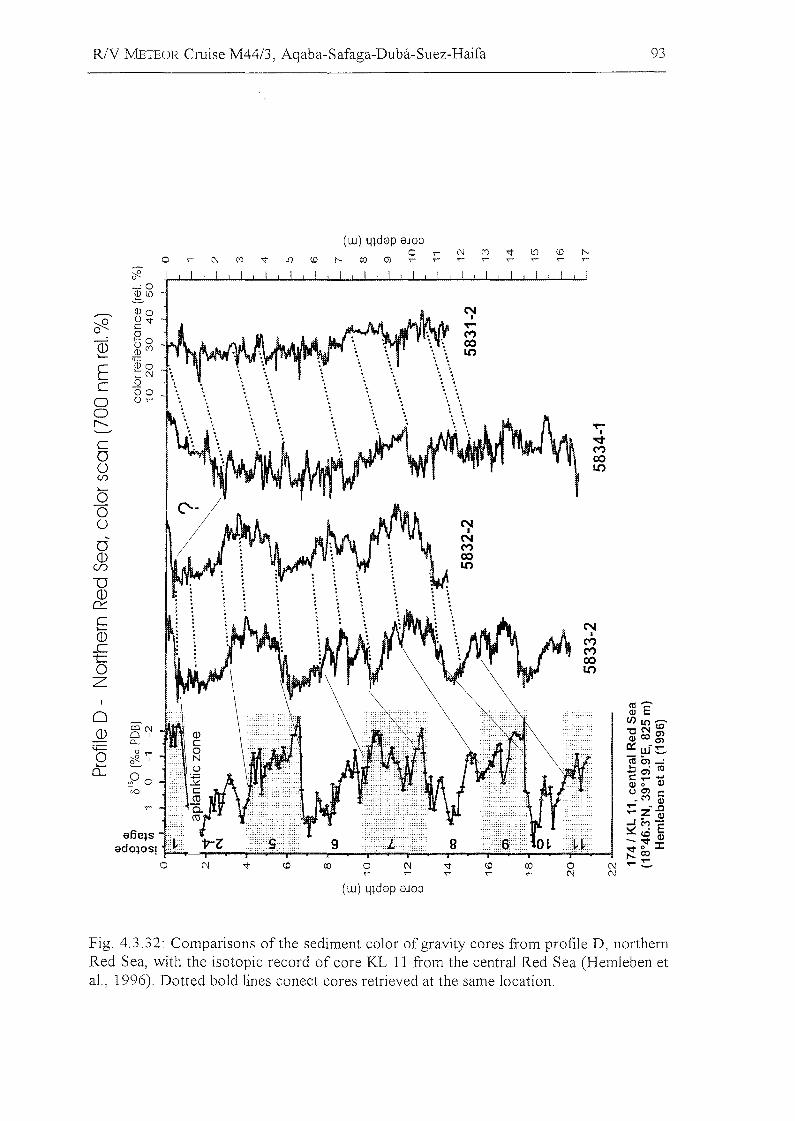
RlV METEOR Cruise M44/3, Aqaba-Safaga-Duba-Suez-Haifa 93
(w) lndep eJOO0 ,.- C'J C<") 'i" l() <0 I'--
0 C'J C<") '1" L'J <.D i'- co (J) ,- ,.- ,- ,- ,.- ,.... ,.- ,-
;R0-,0~l()
~QJo N
I
~ g'i" T""0 0 M(])
+-0 00~('J Lt)
'-
~oE ::C'J
c 000
a 0,.-
ar--... T""
I
C ~M
0 000 Lt)(j)
>-
000 N
I
0NM
(]) 00Cf) Lt)
D(1)
0:::C N'-(]) I
M..c Mt: 000 Lt)
Z('0 .......
0 ~ ECF)ltl .......
(])CCC'J "'CN te0' ~comCL. 0:: - .....~ o ,.... w_
O cJ2.1 roo,...:0:::: ";ai('Opo r:: ..... -
~ 0 ~vo ocnr::
_M ~..... -.c..... z~..Jiv'l-
e6e~s~ . E-.~~
edo~os! '<t0 J:,...co0 C'J 'i" (JJ 0 C'J 'i" <0 C'J ..........-,.... ,.... ,.... C'J
(w) Llldep eJOO
Fig. 4.3.32: Comparisons ofthe sediment color ofgravity cores from profile D, northernRed Sea, with the isotopie reeord of eore KL 11 from the eentral Red Sea (Hemleben etal. , 1996). Dotted bold lines eoneet eores retrieved at the same loeation.
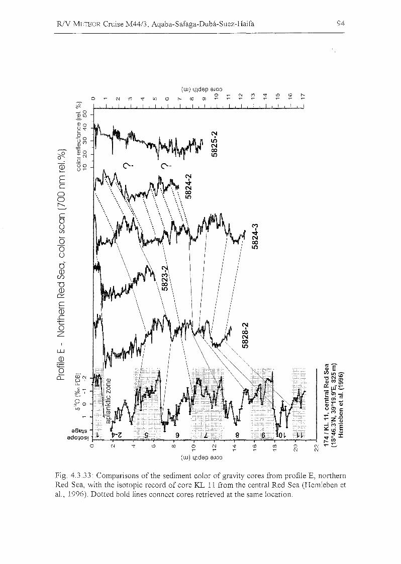
R/V METEOR Cruise M44/3, Aqaba-Safaga-Duba-Suez-Haifa
(w) 41dep eJOOo , (\J ("') '<j' i[) co J'-.
o N ("') '<j' i[) co J'-. co m ' , , , , , ~ ,
94
Ecoor--...
cooCf)
oooo<D
CI)
U<D
a:::.cCD.ctoZ
w<D
'00:
9
NI
LONcoLO
o,(w) 41dep eJOO
B
MI
-.::tNcoLO
Fig. 4.3.33: Comparisons of the sediment color of gravity cores from profile E, northernRed Sea, with the isotopic record of core KL 11 from the central Red Sea (Hemleben etal. , 1996). Dotted bold lines connect cores retrieved at the same location.
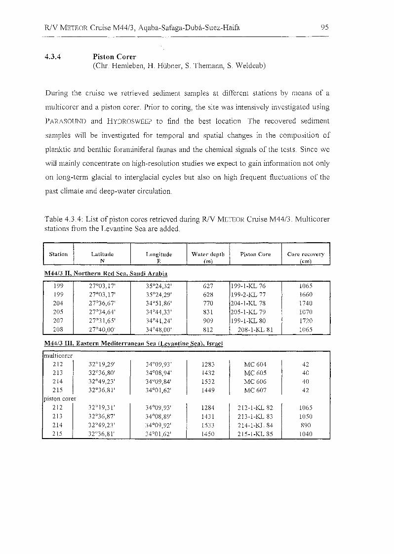
R/V METEOR Cruise M44/3, Aqaba-Safaga-Duba-Suez-Haifa
4.3.4 Piston Corer(Chr. Hemleben, H. Hübner, S. Themann, S. WeIdeab)
95
During the crulse we retrieved sediment sampIes at different stations by means of a
multicorer and a piston corer. Prior to coring, the site was intensively investigated using
PARASOUND and HYDROSWEEP to find the best location. The recovered sediment
sampIes will be investigated for temporal and spatial changes in the composition of
planktic and benthic foraminiferal faunas and the chemical signals of the tests. Since we
will mainly concentrate on high-resolution studies we expect to gain information not only
on lang-term glacial to interglacial cycles but also on high frequent fluctuations of the
past climate and deep-water circulation.
Table 4.3.4: List of piston cores retrieved during R/V METEOR Cruise M44/3. Multicorerstations from the Levantine Sea are added.
Station Latitude Longitude Water depth Piston Core Core recoveryN E (m) (em)
M44/3 n, NOlihern Red Sea, Saudi Arabia
199 27°03,17' 35°24,32' 627 199-1-KL 76 1065199 27°03,17' 35°24,29' 628 199-2-KL 77 1660204 27°36,67' 34°51,86' 770 204-1-KL 78 1740205 27°34,64' 34°44,33' 831 205-1-KL 79 1070207 27°31,65' 34°41,24' 909 199-1-KL 80 1720208 27°40,00' 34°48,00' 812 208-1-KL 81 1065
M44/3 In, Eastern MeditelTanean Sea (Levantine Sea), Israel
multicorer212 32°19,29' 34°09,93' 1283 MC604 42213 32°36,80' 34°08,94' 1432 MC605 40214 32°49,23' 34°09,84' 1532 MC606 40215 32°36,81' 34°01,62' 1449 MC607 42
piston corer
212 32°19,31' 34°09,93' 1284 212-1-KL 82 1065213 32°36,87' 34°08,89' 1431 213-1-KL 83 1050214 32°49,23' 34°09,92' 1533 214-1-KL 84 890215 32°36,81' 34°01,62' 1450 215-1-KL 85 1040
RlY METEOR Cruise M4413, Aqaba-Safaga-Duba-Suez-Haifa 96
4.4 CTD Profiling
(T. Felis, C. Moos)
4.4.1 Methods
A self-contained SEABIRD SBE 19 CTD profiler equipped with a conductivity
temperature-depth-sensor, an oxygen probe and a CHELSEA fluorometer for chlorophyll
a measurements was used at 31 stations in order to study the variability of temperature,
salinity, oxygen, and chlorophyll a throughout the water column. These data provide
important information on water-column stratification and will also support the
interpretation of the stable carbon and oxygen isotope (ö l3 C, Ö180) and nutrient (P04)
analyses of the water sampies recovered from different depths of the water column. All
sensors were calibrated by the manufacturer prior to the cruise. The eTD profiler was
attached to the wire 50 m above the multicorer or, when no multicorer was used, 50 m
above the multinet. Full parameter sets were taken at 0.5 sec intervals both during
downcast and retrieval. Immediately after each CTD profiling the data were transfered to
a PC and the downcast profiles were displayed in standard plots.
At some stations the salinity profiles showed an anomalous varibility of 0.1-0.2 and the
CHELSEA Fluorometer ran out of its range at some stations. At the end of the cruise, the
manufacturer checked the CTD profiler but no malfunction could was detected. The
CTD-recordings from station GeoB 5802-2 were lost during data upload.
4.4.2 Preliminary Results
The temperature/salinity versus depth profiles (Fig. 4.4.1) show the unusually weak
vertical stratification of the water mass in the Gulf of Aqaba, which is mainly determined
by temperature. The contribution of salinity to stratification is negligible (e.g., Reiss and
Hottinger, 1984). Deep vertical water mass mixing reached a maximum depth of about
500 m at the northern end of the Gulf during the period of the cruise. Therefore,
complete homogeneity between the upper water mass and the deep water was probably
not achieved that winter. In the southern part of the Gulf, the upper water mass is more
R/V :rvlETEOR Cruise M44/3, Aqaba-Safaga-Duba-Suez-Haifa 97
stratified and warmer, probably as a result of the beginning summer stratification and/or
the influence of the northward-flowing Red Sea surface waters. The influence of these
warmer and less saline waters can be clearly seen at the southernmost station in the Gulf
(station 5820-3). In the southern part ofthe Gulfa slightly warmer and more saline water
mass was detected in a depth of 330 m (station 5818-2) and 280 m (station 5819-2),
respectively. Compared to the Gulf, the upper water mass of the northern Red Sea is
more stratified which is determined by both temperature and salinity.
The temperature-salinity (T-S) diagram for the northern Gulf of Aqaba shows the two
characteristic water masses of upper and deep water with their difference mainly
determined by temperature (Fig. 4.4.2). The T-S diagram for the southern part of the
Gulf reveals slightly warmer and more saline water mass (arrow) in a depth of about 300
m. Comparison of the T-S diagrams for the northern Red Sea and the Gulf of Aqaba
shows that the deep-water mass ofthe latter is colder and slightly more saline.
Although the CTD-recorded absolute data for dissolved oxygen are not reliable, a
comparison between the northern Red Sea and the Gulf of Aqaba shows the lack of a
pronounced oxygen minimum in the latter (e.g., Reiss and Hottinger, 1984) (Fig. 4.4.3).
R/V METEOR Cruise M44/3, Aqaba-Safaga-Duba-Suez-Haifa 98
0 0 0 0 0 ..c:-0 0 0 0 0 0 0 0' 0 0 0 0 0 0 ::l0 0 0 0 0 0 0 0 0 0 ,,- N 0J -:j"
00 ,,- N 0J -:j" LO (D r--. co m ,,- ,,-(j)
LOvg2Z:
~~>I\f1..,",(j) cuvOv
.,- (1)I
wJ'I r-- Cf)N
gz:z CD ""0I.[) (1)
~'Ov 0:::c'-
g~z: I- 8'62 (1)..c
g'2Z: 9'OV t0Z
.,-I
S'ZZ Z'Ov-:j"
"'<tCD ..c:I.[)
t0Z
g ~z: I- 8'62g'z:z: ~' ~v ..c:-::l
~0
C0 (j)I
---.. g ~z:0
() LOv N(j) CD
0SI.[)'---"
Q) I- CI)I-
S'OZ:0...
::J 2'Ov '---"+-' >-CU
'~z~I- rv :t:: NQ) (j) C I
0)
0... .,-
E CU CD~~I- Cf) I.[)
~ S'OZ: 20v
g~z:
~(j) rv N
I CUCD.,- .0CD CUI.[) 0-
g'OZ: 2'017 «4-
g' ~z: c: 0N
I ~r-- ::J.,-
<.9CDI.[)
S'OZ
S ~z:
L::N
~I
<0
---- .,-
(1) CD
'- I.[)
::J--..... Cf)CU ---- c: ':l'-:>,(1) ..... <0o....c 0
E= CD
~S5I.[)
'''L 5!: I I ,r:: N ..c:I tr-- 00 zCD
! I ,! ! , I , I.[)
S'OZ , ,0 0 0 0 0 0 0 0 0 0 0 0 0 0 0
0 0 0 0 0 0 0 0 0 0 0 0 0 0N 0J -:j" LO (D r--. co m 0 ,,- N 0J -:j"
,,- ,,-
(W) lIldECI
Fig. 4.4.1: North-south transect of CTD profiles (temperature and salinity) from thenorthern Gulf of Aqaba to the northern Red Sea,
RlV METEOR Cruise M44/3, Aqaba-Safaga-Duba-Suez-Haifa 99
22.0
~.z 21.5~Q)Q.
E~ 21.0
NorthernGulf of Aqaba
22.0
21.5
21.0SouthernGulf of Aqaba
40.2 40.4 40.6 40.8 40.2 40.4 40.6 40.8
24.0 .--.--r--.--r--.--r--r--r--,..---,
0' 23.0Q)I
:::JmW 22.0Q.
EQ)
f-21.0
+ -lHHiJf;.-tq, 5827-1fr+
5844-1OO~
Deep water
Northern Red Sea
24.0
23.0
22.0
21.0 Golf 01Aqaba.39.8 40.0 40.2 40.4 40.6 40.8
Salinity (psu)
39.8 40.0 40.2 40.4 40.6 40.8
Salinity (psu)
Fig. 4.4.2: Temperature-salinity diagrams for the Gulf of Aqaba and the nOlihern RedSea revealing characteristic water masses. Data used are from the stations shown inFigure 4.4.1.
0
200
400
--- Gulf of AqabaE 600 5818-2
-----.c........Q..(1) 800
0
1000
1200
14002 345 6 7 8
Oxygen (mi/I)
Fig. 4.4.3: CTD profiles of dissolvedoxygen from the Gulf of Aqaba and thenorthern Red Sea
R/V METEOR Cruise M44/3, Aqaba-Safaga-Duba-Suez-Haifa 100
4.5
4.5.1
4.5.1.1
Sampling of Plankton in the Water Column
Dinoflagellate Investigations
(S. Meier)
Introducti011
Dinoflagellates are unicellular, biflagellated algae that are known from most aquatic
environments. They are a major group of the marine plankton and can live
autotrophically, heterotrophically or even be symbiotic and parasitic. During their life
cycle, which can be very complex, they generally pass through a vegetative-thecate stage
in which they are able to swim actively with their two flagellae. This stage is followed by
the formation of resting cysts, which can be induced by adverse environmental
conditions. The cyst material can be organic or calcareous. The only species forming a
vegetative-coccoid cyst stage with a calcareous wall is Thoracosphaera heimii.
Calcareous dinoflagellate cysts have been overlooked for a long time due to their size
between nannoplankton and foraminifera, and because they are dissolved during the
preparation of palynological sampies. Recent studies showed that they are a useful proxy
far palaeoceanographic reconstruction. However, knowledge about their distribution in
the water column and in the sediments is still quite limited, especially in the Gulf of
Aqaba, the northern Red Sea, and the Levantine Basin, which have never been
systematically investigated for calcareous dinoflagellate cysts. Their spatial distribution in
combination with environmental parameters such as temperature, salinity, nutrient
supply, stratification, etc. may lead to a better understanding of their ecological
preferences and help to understand their paleoecological signal. For these purposes,
water and sediment sampies were taken during the cruise and living calcareous
dinoflagellate cysts were isolated from the sampies for culturing experiments under
controlled laboratory conditions.
R/V J\!1ETEOR Cruise M44/3, Aqaba-Safaga-Duba-Suez-Haifa 101
4.5.1.2
4.5.1.2.1
Sampies
Water SampIes
Water from a depth of about 5 m depth was sampled with the ship's membrane pump
during daytime on most transits and geophysical profiles (Tab. 4.5.1). The plankton
content of a measured amount of liters was concentrated with a two-filter system (100
I-un pre-filter and 10 !J.m end-filter) in all bottle. In general, three sampIes were taken
per day (ca. 08:00-12:00; 12:00-16:00, 16:00-20:00 board time), but depending on the
volume of plankton in the seawater, the filters had to be cleaned every 100 to 600 liters,
which means that in regions with higher plankton concentrations, more sampIes had to be
taken. In total, 41 sampIes were taken (Tab. 4.5.1).
The 1 I of concentrated seawater was filtered through a 5 J-Lm polycarbonate filter down
to 100 ml. Apart of this water was analysed with a light microscope with special notive
taken of the ca1careous dinoflagellate cysts. Living cysts were isolated and cultured in
polyterene Cell Wells containing different culture media (f/2 35%0 and K 35%0 mixed
with filtered sea water) at temperatures of about 20°C and using the local day/night
cycle. These cultures will be used for laboratory experiments under controlled conditions
at the University of Bremen.
The remaining part of the sampie was fixed with 37% formaldehyde at a final
concentration of3-4% and stored in the dark at 4°C.
4.5.1.2.2 Sediment Sampies
At 29 stations sediment sampies were taken from one core (diameter 9,5 cm) of the
multicorer. Fresh material of the upper 1 cm of each core was stored tagether with same
bottom water in polycarbonate flasks at a temperature of 4°C in the dark to prevent
living cysts from hatching. These sampIes will be analysed for living calcareous
dinoflagellate cysts to begin the unicellular culture investigations at the University of
Bremen.
The remaining segmant of the core was cut into 1 cm scilces and stored in petri dishes at
4°C. These cores will be analysed for their content of calcareous dinoflagellate cysts. The
RlY METEOR Cruise M44/3, Aqaba-Safaga-Duba-Suez-Haifa 102
distribution pattern in relation to environmental characteristics of the upper water
column are of interest far reconstructing climatic changes reflected in the changes in the
associations of calcareous dinoflagellate cysts during the time span represented by the
core.
4.5.1.3 Preliminary Results
Water sampIes were taken in three differerent regions: the Gulf of Aqaba, the nOlihern
Red Sea and the Levantine Basin. In the Gulf of Aqaba the plankton concentration was
higher than in the other regions. In every sampIe a lot of different dinoflagellate species
could be found of which most of them were thecate stages. Four different species of
calcareous dinoflagellate cysts could be identified: Thoracosphaera heimii,
?Sphaerodinella albatrosiana, ?Sphaerodinella tuberosa and Scrippsiella regalis from
which the first three could be cultured.
In the northern Red Sea the plankton concentration was lower than in the Gulf of Aqaba
and dinoflagellates were less abundant, but still common. Beside the calcareous-cyst
producing dinoflagellate species, which were also found in the Gulf of Aqaba (apart from
S. regalis) , at least three as yet unidentified species were found and cultured.
The calcareous dinoflagellate cyst associations of the Gulf of Aqaba and the nOlihern
Red Sea seem to be similar to those of the Atlantic Ocean and the Arabian Sea, which
are weil known from recent studies at the University ofBremen.
The sampIes from the Levantine Basin had approximately the same plankton content as
the sampIes from the northern Red Sea and were not used for culturing on board due to
shortness oftime. Raw material will be examined at the University ofBremen.
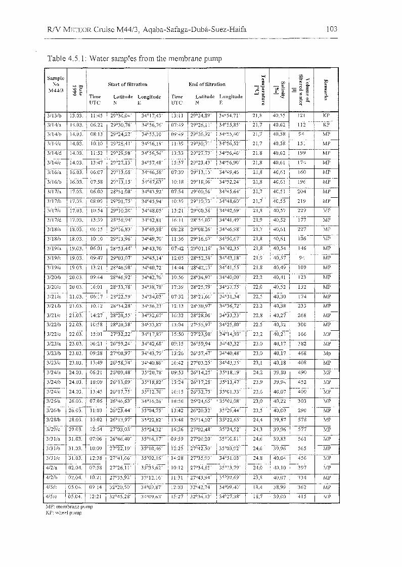
R/V METEOR Cruise M44/3, Aqaba-Safaga-Duba-Suez-Haifa
Table 4.5.1: Water sampIes from the membrane pump
103
Smnple '"'l S'" ;- -< :;e
No Start of fiJtration End of filtration S [f) ... 0
~5' -"" " '" ::- :::M4413 ° '" f[ := c.. 3 ;;
'C~ n.,'C'" Time Latitude Longitude Time Latitude Longitude -" ,~
:;:; '" ~;- ~ 0UTC N E UTC N E ... '" ...,
'" .,
3/13/b 13.03. 11:45 29°30,04' 34°17,43' 13:11 29°24,89' 34°54,71' 21,8 40,55 121 KP
3/14/a 14.03. 06:22 29°30,76' 34°56,76' 07:49 29°26,11' 34°55,85' 21,7 40,62 112 KP
31l4/b 14,03. 08:13 29°24,22' 34°SS,lO' 09:49 29°26,92' 34°55,40' 21,7 40,58 94 MP
31l4/c 14,03, 10:10 29°28,41' 34°56,18' 11:39 29°30,71' 34°56,52' 21,7 40,58 151 MP
3/14/d 14,03, 11:52 29°29,98' 34°56,56' 13:33 29°27,73' 34°56,46' 21,8 40,62 199 MP
3/14/e 14,03. 13:47 29°27,13 ' 34°57,48' 15:57 29°23,43' 34°56,90' 21,8 40,61 174 MP
31l6/a 16.03. 06:07 29°13,68' 34°46,58' 07:39 29°13,15' 34°49,46' 21,8 40,61 160 MP
311 6/b 16.03 07:58 29°13,15' 34°47,63' 10:18 29°18,96' 34°52,24' 21,8 40,61 196 MP
311 7/a 17,03, 06:00 28°51,08' 34°43,92' 07:54 29°00,56' 34°45,64' 21,7 40,51 204 MP
31l7/b 17.03. 08:09 29°01,75' 34°45,94' 10:39 29°10,73' 34°48,60' 21,7 40,55 219 MP
31l7/c 17.03, 10:54 29°10,20' 34°48.05' 13:21 29°00,38' 34°42,69' 21,8 40,57 229 MP
3/17/d 17,03, 13:39 28°58,94' 34°42,81' 16:11 28°54,03 ' 34°41,49' 21,9 40,52 177 MP
3/18/a 18,03, 06:15 29°16,83' 34°49,88' 08:28 29°08,26' 34°46,98' 21,7 40,61 227 MP
3/18/b 18,03. 10:10 29°13,96' 34°49,70' 11:36 29°16,67' 34°50,67' 21,8 40,61 106 MP
3/19/a 19,03, 06:01 28°53,44' 34°43,76' 07:42 29°01,18' 34°42,35' 21,8 40,54 146 MP
31l9/b 19,03, 09:47 29°03,07' 34°45,14' 12:05 28°52,58' 34°43,18' 21,9 40,57 94 MP
3119/c 19.03, 13:21 28°46,98' 34°40,72' 14:44 28°42,13' 34°41,55' 21,8 40,49 109 MP
3/20/b 20.03, 09:44 28°46,92' 34°42,76' 10:56 28°34,97' 34°40,00' 22,2 40,41 123 MP
3/20/c 20.03. 16:01 28°33,78' 34°38.78' 17:39 28°25,79' 34°37,75' 22,0 40,52 132 MP
3/2l!a 21.03, 06:17 28°22.59' 34°34,03 ' 07:32 28°21,66' 34°31,34' 22,5 40,30 174 MP
3/21/b 21.03. 10:12 28°34,28' 34°36,23 ' 12:13 28°30,97' 34°36,72' 22,2 40,38 233 MP
3/21/c 21.03. 14:27 28°20,55' 34°32,67' 16:32 28°28,06' 34°33,33 ' 22,8 40,27 268 MP
3/22/b 22,03. 10:58 28°20,38' 34°33,87' 13:04 27°55,97' 34°25,80' 22,5 40,32 300 MP
3/22/c 22,03. 15:01 27"32,22' 34°17,87' 15:50 27°23,98' 34°14,93' 23,2 40,21 166 MP
3/23/a 23.03. 06:21 26°59,24' 34°42,68' 09:15 26°59,94' 34°43,32' 23,0 40,17 382 MP
3/23/b 23.03, 09:28 27°00,97' 34°43,79' 13:26 26°57,47' 34°40,48' 23,0 40,17 468 Mp
3/23/c 23,03, 13:49 26°58,74' 34°40,86' 16:42 27°03,25' 34°43,35' 23,1 40,18 408 MP
3/24/a 24,03, 06:21 26°09,48' 35"20,78' 09:53 26°14,25' 35°18,19' 24,2 39,80 490 MP
3/24/b 24,03. lO:09 26°13,09' 35°18,82' 13:24 26°17,28' 35°13,47' 23,9 39,94 452 MP
3/24/c 24.03. 13:45 26°17,75' 35°12,76' 16:15 26°32,75' 35°01,33' 23,6 40,07 400 MP
3/26/a 26.03. 07:06 26°46,63' 34°16,26' 10:50 26°24,65 ' 35°02,08' 23,0 40,22 303 MP
3/26/b 26,03. 11:03 26°23,44' 35°04,75' 13:42 26°20,32' 35°29,44' 23,5 40,00 290 MP
3/28/b 28.03, 10:02 26°13,97' 35°22,82' 13:48 26°14,02' 35°22,65 ' 24,4 39,87 578 MP
3/29/c 29,03. 12:54 27°03,03 ' 35°24,32' 16:26 27°02,48' 35°24,52' 24,3 39,96 577 MP
3/31/a 31.03, 07:06 26°46,40' 35°16,17' 09:59 27°20,20' 35°10,81' 24,6 39,83 561 MP
3/3l!b 31.03. 10:09 27°22,19' 35°10,46' 12:25 27°42,50' 35°03,92' 24,6 39,96 565 MP
3/3l!c 31.03. 12:38 27°41,66' 35°02,16' 14:28 27°35,93 ' 34°51,03' 24.8 40,04 456 MP
4/2/a 02,04, 07:58 27°26.11' 35°33.62' 10:12 27°34,85 ' 35°13,79' 24,0 40.10 397 Iv!P
4/2/b 02,04. 10:21 27°35,92' 35°12.16' 11 :31 2T43.94' 135°02.69' 23,8 40,07 334 MP
41SIb 05.04. 09:14 32°20,50' 34°09,87' 12:03 32°42,74' I 34°0940' 18:4 I 38,99 362 MPi .4/5/c 05,04, 12:21 32°45.28' 34°09,63' 15:27 32°36,13 ' 34°27,38' 18,7 I 39,00 415 MP
MP: membrane pumpKP: wheel pump
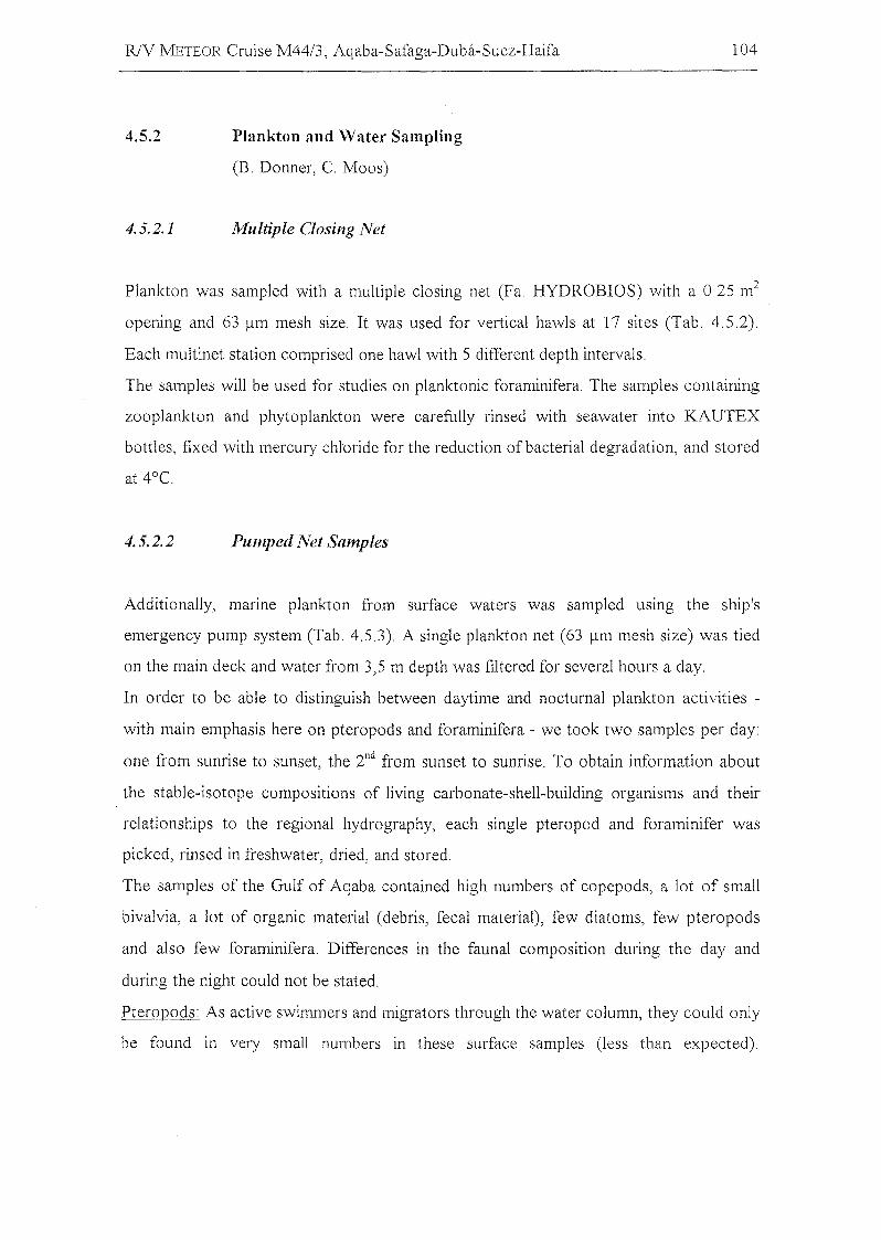
R/V WIETEOR Cruise M44/3, Aqaba-Safaga-Duba-Suez-Haifa 104
4.5.2
4.5.2.1
Plankton and Water Sampling
(B. Donner, C. Moos)
Multiple Closing Net
Plankton was sampled with a multiple closing net (Fa. HYDROB10S) with a 0.25 m2
opening and 63 flm mesh size. 1t was used for vertical hawls at 17 sites (Tab. 4.5.2).
Each multinet station comprised one hawl with 5 different depth intervals.
The sampies will be used tür studies on planktonic foraminifera. The sampies containing
zooplankton and phytoplankton were carefully rinsed with seawater into KAUTEX
bottles, fixed with mercury chloride for the reduction ofbacterial degradation, and stored
at 4°C.
4.5.2.2 Pumped Net Sampies
Additionally, manne plankton from surface waters was sampled usmg the ship's
emergency pump system (Tab. 4.5.3). A single plankton net (63 flm mesh size) was tied
on the main deck and water from 3,5 m depth was filtered for several hours a day.
In order to be able to distinguish between daytime and nocturnal plankton activities
with main emphasis here on pteropods and foraminifera - we took two sampies per day:
one from sunrise to sunset, the 2nd from sunset to sunrise. To obtain information about
the stable-isotope compositions of living carbonate-shell-building organisms and their
relationships to the regional hydrography, each single pteropod and foraminifer was
picked, rinsed in freshwater, dried, and stored.
The sampies of the Gulf of Aqaba contained high numbers of copepods, a lot of small
bivalvia, a lot of organic material (debris, fecal material), few diatoms, few pteropods
and also few foraminifera. Differences in the faunal composition during the day and
during the night could not be stated.
Pteropods: As active swimmers and migrators through the water column, they could only
be found in very small numbers in these surface sampies (less than expected).
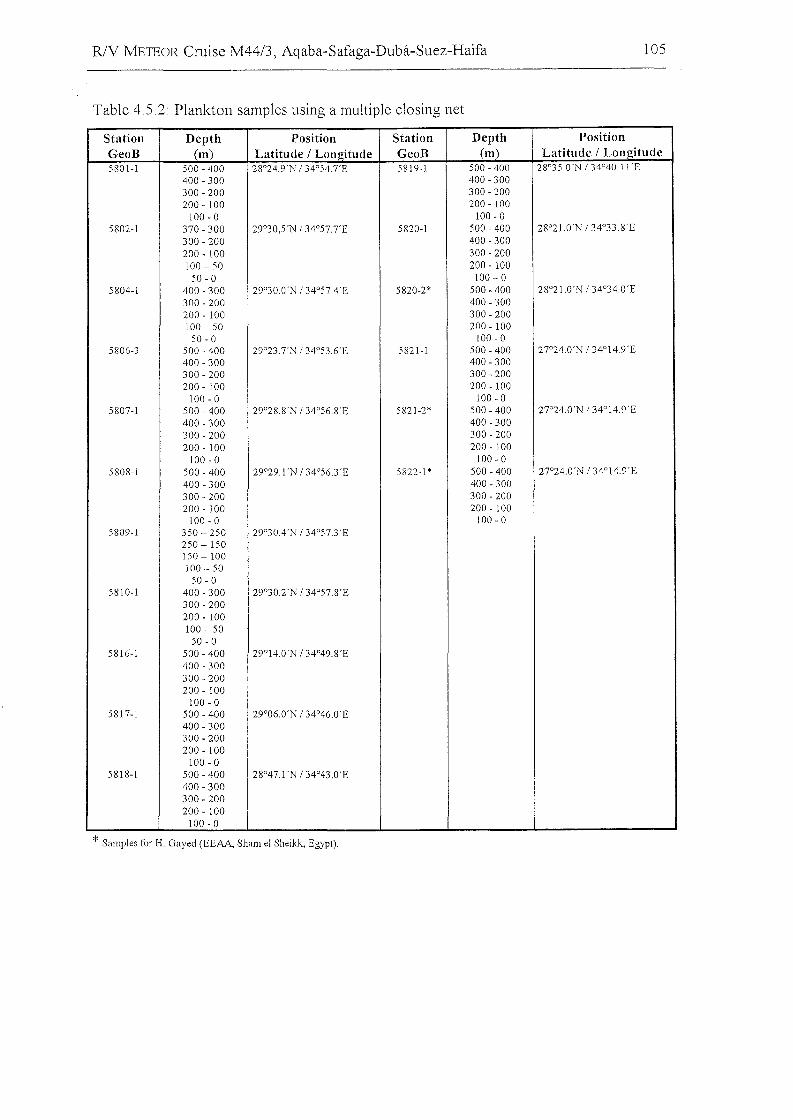
RlY METEOR Cruise M44/3, Aqaba-Safaga-Duba-Suez-Haifa
Table 4.5.2: Plankton sampIes using a multiple closing net
105
Station Depth Position Station Depth PositionGeoB (m) Latitude I Longitude GeoB (m) Latitude I Longitude5801-1 500 - 400 28°24.9'N 134°54.7'E 5819-1 500 - 400 28°35.0'N 134°40.11'E
400 - 300 400 - 300300 - 200 300 - ZOO200 - 100 200 - 100
100 - 0 100 - 0580Z-1 370 - 300 Z9°30,5'N /34°57,7'E 58Z0-1 500 - 400 Z8°Z1.0'N 134°33.8'E
300 - ZOO 400 - 300ZOO - 100 300 - ZOO100 - 50 ZOO - 100
50 - 0 100 - 05804-1 400 - 300 Z9°30.0'N 134°57A'E 58Z0-Z* 500 - 400 Z8°Z1.0'N 134°34.0'E
300 - ZOO 400 - 300ZOO - 100 300 - ZOO100 - 50 ZOO - 100
50 - 0 100 - 05806-3 500 - 400 Z9°Z3.7'N 134°53.6'E 5821-1 500 - 400 27°Z4.0'N 134°14,9'E
400 - 300 400 - 300300 - ZOO 300 - ZOOZOO - 100 ZOO - 100
100 - 0 100 - 05807-1 500 - 400 Z9°28.8'N /34°56.8'E 58Z1-2' 500 - 400 27°Z4,O'N 134°14,9'E
400 - 300 400 - 300300 - ZOO 300 - ZOO200 - 100 200 - 100
100 - 0 100 - 05808-1 500 - 400 Z9°Z9,l'N 134°56.3 'E 582Z-1 * 500 - 400 27°24.0'N 134°14.9'E
400 - 300 400 - 300300 - 200 300 - ZOO200 - 100 200 - 100
100 - 0 100 - 05809-1 350 - Z50 29°30A'N 134°57.3'E
250-150150-100100 - 50
50 - 05810-1 400 - 300 Z9°30.Z'N 134°57.8'E
300 - 200200 - 100100 - 50
50 - 05816-1 500 - 400 29°14.0'N 134°49.8'E
400 - 300300 - ZOOZOO - 100
100 - 05817-1 500 - 400 Z9°06.0'N 134°46.0'E
400 - 300300 - ZOOZOO - 100
100 - 05818-1 500 - 400 Z8°47.1'N 134°43,O'E
400 - 300300 - ZOOZOO - 100
100 - 0
* Sampies tor H, Gayed (EEAA, Sham el Sheikk, Egypt),
RlV METEOR Cruise M44/3, Aqaba-Safaga-Duba-Suez-Haifa 106
Foraminifera: Warm-water surface species (Globigerinoides rubel', Globigerinoides
sacculifer) were dominant. Additionally, we found species with a wider temperature
range (Orbulina universa, Globigerinella siphon~fera, Globigerinella calida). All these
species are spinose and symbiont bearing. According to Reiss et al. (1980) the spinous
species are abundant in the Gulf of Aqaba, but deeper-dwelling nonspinous foraminifera
of the genus Globorotalia are absent.
But in two samples on the transect in the northern part of the Gulf off Ras Burka we
could find three different species of Globorotalia (menardii, truncatulinoides and
inflata). The study of the multinet samples (subsurface water) at home will probably
show up to which depths those species are to be found.
Table 4.5.3: Plankton samples filterted from the emergency pump system.
Start of filtration End 01' filtration
SampIe Nr. Date 1999 Time UTC Date 1999 TimeUTC
FP 1 16.03. 11:00 16.03. 18:00
FP 2 16.03. 18:00 17.03. 6:00
FP 3 17.03. 6:00 1703. 18:00
FP 4 17.03. 18:00 18.03. 800
FP 5 18.03. 6:00 l8.03. 18:00
FP 6 18.03. 18:00 [9.03. 8:00
FP7 19.03. 6:00 19.03. 18:00
FP 8 19.03. 18:00 20.03. 6:00
FP 9 20.03. 6:00 20.03. 18:00
FP 10 20.03. 18:00 21.03. 6:00
FP 11 21.03. 6:00 21.03 18:00
FP 12 22.03. 18:00 22.03. 6:00
FP 13 22.03. 6:00 22.03. 14:00
FP 14 22.03. 14:00 23.03. 6:00
FP [5 23.03. 6:00 24.03. 6:00
FP 16 26.03. 6:00 26.03. 18:00
FP 17 26.03. 18:00 27.03. 06:00
FP [8 27.03. 6:00 27.03. 18:00
FP 19 27.03. 18:00 28.03. 06:00
FP 20 28.03. 6:00 2803. [8:00
FP21 28.03 18:00 2903 06:00
FP 22 2903 6:00 29.03 18:00
FP 23 2903 18:00 30.03 06:00
FP 24 3003 6:00 31.03 06:00
R1V J\!fETEOR Cruise M4413, Aqaba-Safaga-Duba-Suez-Haifa 107
4.6 Geochemistry in the Brine filled Shaban Deep
(H. Blaschek, S. Klauke, M. O. Moammar, M. Schmidt, M. Schmitt, P.
Stoffers)
4.6.1 Introduction
The Red Sea is a natural laboratory where the influences of early rifting, spreading,
volcanism, and hydrothermal processes on tectonics and sedimentation can be studied.
Within the central rift valley of the Red Sea a number of brine-filled depressions occur.
The high salinities are due to leaching of subbottom Miocene evaporites.
Our work concentrated on the Shaban Deep in the northern Red Sea at 26°12.66'N and
35°21.47'E. This deep consists of four basins (Shaban-S, -E, -N, -W) filled with high
saline brines. The interface between Red Sea Deep Water (RSDW) and the brine occurs
at a depth of 1325m (Hartmann et al. 1998) in all four basins. A second interface was
found in the southern and eastern basins at a depth of 1459m.
4.6.2 Objectives
One ofthe major goals ofcruise M44/3 was the detailed sampling ofthe brine bodies and
the brine interfaces in the Shaban Deep. High-resolution spatial sampling (decimeter to 1
meter sections) should give a better understanding of the geochemical cycles of trace
elements and other inorganic compounds in, and between, the convecting brine layers
and the overlying RSDW. Besides sampling the brine with a rosette water sampier (+
multiprobe), high-resolution sampling of dissolved and particulate compounds was
carried out in the seawater/brine interface with a newly designed (by M. Schmitt,
Geochemische Analysen) Interface Water Sampier (IWS, Fig. 4.6.1).
The major aim of the trace gas (hydrocarbons, noble gases) studies was to understand
the genesis of the gases dissolved in the brine layers of Shaban Deep and their exchange
with overlying RSDW. In particular, the stable-isotope compositions of the gases in the
brine should give evidence both of thermal degradation mechanisms of organic matter
buried in the sediments and mantle-derived fluid input. Furthermore, secondary
RlV J\llETEOR Cruise M44/3, Aqaba-Safaga-Duba-Suez-Haifa 108
degradation processes like inorganic or bacterial oxidation of hydrocarbons may be
resolved by the stable isotope signature of, e.g., CH4 .
J\lucrobiological and inorganic results of investigations at the seafloor/brine and
brine/RSDW interfaces will be linked to the measurements of hydrocarbons. We expect a
new clue to formation and degradation mechanisms of organic carbon in this extreme
environment, as postulated by Faber et al. (1998).
Additional sediment sampies were taken at several core stations in the northern Red Sea.
Isotope geochemical investigations of free and adsorbed hydrocarbons in the sediment
sampies should give information about the hydrocarbon sources (thermal degradation) in
deeper sediment layers and/or bacterial processes near the sediment surface.
4.6.3
4.6.3.1
4.6.3.1.1
First Results
Sampling the Sea Water/Brine Interface at Shaban Deep with the
Interface- Water-Sampler
Introduction
Water sampling in stratified water bodies, i.e., of brines in the Red Sea, is commonly
performed by a rosette sampier equipped with 12 or more Niskin bottles. Sampling is
done by lowering the rosette carefully down into the brine layer and closing individual
Niskin bottles whilst descending. However, because of the large size of the rosette
system and many metal parts, the interface layers can be physically disturbed by mixing,
and metal parts may contaminate water sampies and influence the chernical redox cycles.
To overcome the mixing effect, to prevent ehemieal contamination by metals, and to
eolleet water sampies at an interval of < 0,5 m simultaneously by only one trigger
impulse, we designed a new so-called IWS (Interface Water ,S,ampler, see schematie
drawing Fig. 4.6.1). The aim ofusing the IWS is to colleet a profile ofwater sampies in
only one step from stratified water bodies like brines in the Red Sea. The IWS system
was tested for the first time on-board the ship R/V METEOR during cruise M44/3 at the
Shaban Deep (R/V METEOR station 202d).
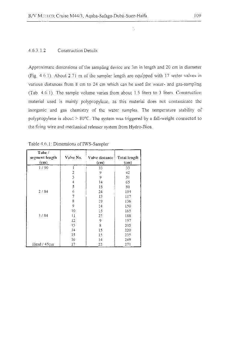
R1V METEOR Cruise M44/3, Aqaba-Safaga-Duba-Suez-Haifa 109
4.6.3.1.2 Construction Details
Approximate dimensions of the sampling device are 3m in length and 20 cm in diameter
(Fig. 4.6.1). About 2.71 m of the sampier length are equipped with 17 water valves in
various distances from 8 cm to 24 cm which can be used for water- and gas-sampling
(Tab. 4.6.1). The sampie volume varies from about 1.5 liters to 3 liters. Construction
material used is mainly polypropylene, as this material does not contaminate the
inorganic and gas chemistry of the water sampies. The temperature stability of
polypropylene is about > 80°e. The system was triggered by a fall-weight connected to
the firing wire and mechanical releaser system from Hydro-Bios.
Table 4.6.1: Dimensions ofIWS-Sampler
Tube /segment length Valve No. Valve distanee Total lenl"rth
(ern) (ern) (ern)11 90 1 33 33
2 9 423 9 514 14 655 15 80
2 / 84 6 24 1047 13 1178 19 1369 14 15010 15 165
3 / 84 11 23 18812 9 19713 8 20514 15 22015 15 23516 14 249
Head / 45cm 17 22 271
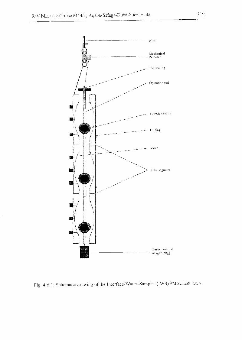
R/V METEOR Cruise M44/3, Aqaba-Safaga-Duba-Suez-Haifa 110
- Wire
Top sealing
Operation rod
Plastic coveredWeight [5kg]
Valve
Tube segment
O-Ring
Spheric sealing
MechanicalRcleaser
---
H
i--Fig. 4.6.1: Schematic drawing ofthe Interface-Water-Sampler (IWS) @M.Sclunitt, GCA
R/V J'vlETEOR Cruise M44/3, Aqaba-Safaga-Duba-Suez-Haifa 111
4.6.3.1.3 Handling Onboard the Vessel
The IWS sampier is carefully lowered by a winch down to the beginning of the brine
interface. Control of the water depth was established by reading the wire length and
additionally by a pinger system, which was installed about 5 m below the end of the IWS.
Careful insertion of the lower end of the IWS into the brine body was therefore possible.
The sampling procedure was visualized (see Fig. 4.6.2) by echosounding. The upper line
is the signal from the pinger and the lower line represents the brine surface.
After penetration of the system across the sea-water/brine interface, the IWS was
triggered by the fall weight with a running time of about 10 minutes. After retrieval of
the IWS, the sampier was secured outboard and water sampies were collected starting at
the top ofthe IWS (valve 1). Salinity and pH measurements were performed immediately
after the sampling. A high spatial resolution could be measured (Fig. 4.6.3) with the IWS
system. The steep gradient of pH and salinity between water depth 1328 m and 1330 m
(cable length) defines an interface layer of about 80 cm thickness.
4.6.3.2 Water and Sediment Samplesfrom the Nortltern Red Sea
The shipboard data of 10 hydrocast stations in the southern, eastern, and northern sub
basins of the Shaban Deep and sediment sampies of the northern Red Sea are presented
in the tables 4.6.2-4.6.5. Sampie locations at the Shaban Deep are plotted in Fig. 4.6.4. A
temperature and sound-velocity profile, measured with the multiprobe, plotted against
water depth (pressure) ofthe Shaban Deep east basin (Figure 4.6.5). Steep temperature,
oxygen and sound-velocity (which is related to salinity) gradients were detected at about
1330 m (rope length) for all investigated basins (Fig. 4.6.4). A second interface was
measured in the southern and eastern basin at about 1365m (rope length).
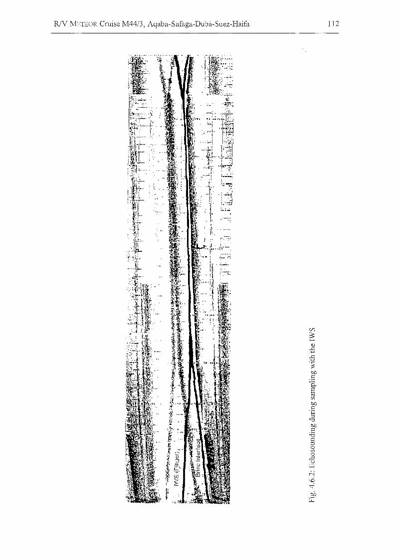
R/V METEOR Cruise M44/3, Aqaba-Safaga-Duba-Suez-Haifa 112
I'," ". '.~
:"i~'~'~~~~,,.I•• ~-..
,i crJ'
:f't:1,! V
;\~
'tC" 't: .
ro : '"
.;~,'....4 ...~'.:.J.r
I. "/:111::"",I" ." ,I ", ,.;,....:~
; ~ ... : . 'j"ir.'" .~,~1·'. ' :';':: . :"lr,"" 'V,' -?:'"
:t ,-,' "-~,I
~ '1'';- :.',: ,~ . ~ ,I.', ~~~, u.,
tt!;~,,:~i~.1 :,.. ••:\ ....\':•..:~
l!"~ .
;1': ,,- ... ~i7f:'~
" ' ~ ."
~~::::':':':-',./;:
, , I ... Vi I: -1"i 'rs-J" ~ '4-". .. """r ",~.:
4 ~' ~-: ,.~~J,~'~' -- , ~~. 1"" I" 1.. :.: ~.
~tf:;- l ~·t+-·i
r I I"~, , ,,',.. c:,"t,oI.... t.. j I 'irk1r'- , . ~;.. .. ,_,.rj:-~~"r tr. ..·H, I >I
~",4r.IJ':
"'~i:' '~L·tI.,~~~~:~ '/~ i
j' 'i: ' ,".. ,11:
l._~
,f';:'-'.1-'
i '.i 111' .......
'~ ," .. - ,....1;·.1..... '.' i' .,.! ..,,~ i - . ", ..-..;: ,:r " l~ I : ',~j
1' •• , .'( , ,I, ~_:.~1·I. ~
"j.I i''''''''-I ••• ...
Yf-- ':', l" ," ~'-l~--, ~t. ..,
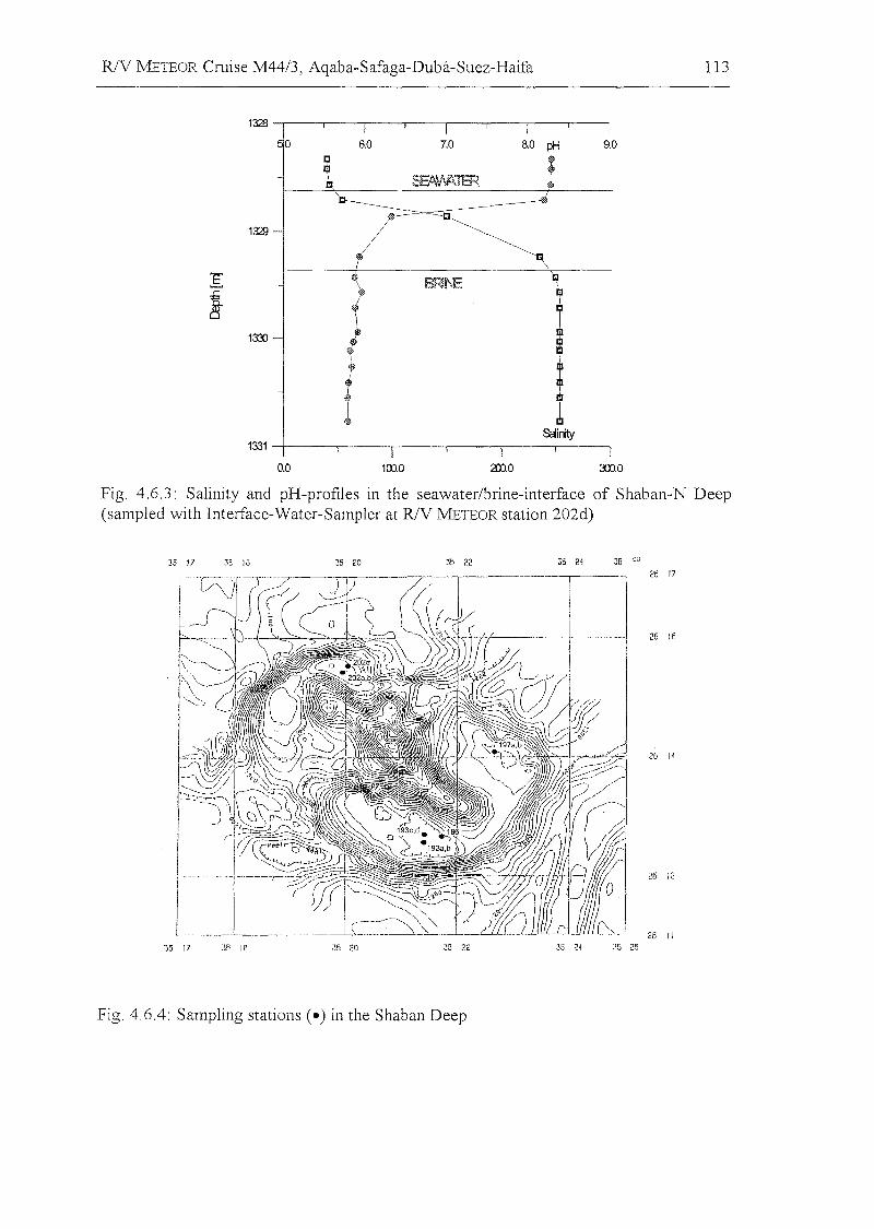
R1V METEOR Cruise M44/3, Aqaba-Safaga-Duba-Suez-Haifa
26 16
26 14
26 12
26 11
113
"35 17 35 1B 35 20 35 22 35 24 :\~; 25
Fig. 4.6.4: Sampling stations Ce) in the Shaban Deep
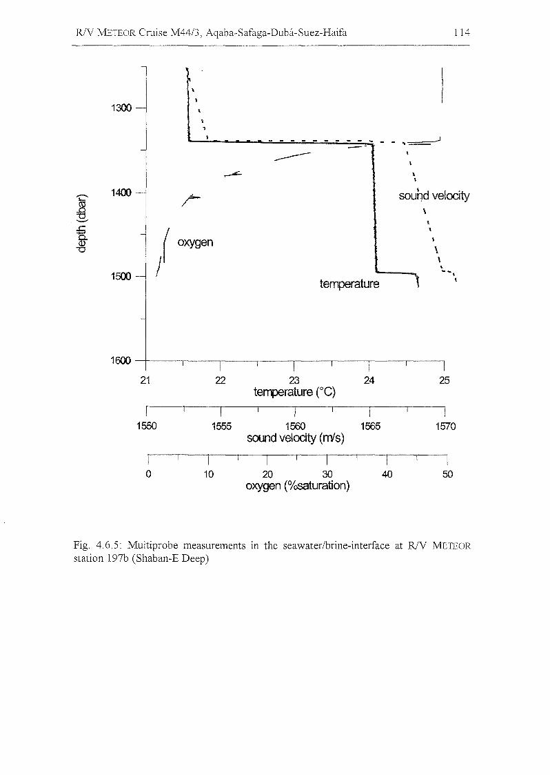
R/V METEOR Cruise M44/3, Aqaba-Safaga-Duba-Suez-Haifa 114
1300\
'I
- - - - - - - - - .. - - .J..---- \\
"2' 1400 r sound velocity~"'0
\-- \
.t=.
l\
0. oxygen<J.)'"0 \,..
1500 -~ •temperature
,
1600
21 22 23 24 25terrperature ce)
I I I I I1550 1555 1560 1565 1570
sound velodty (m's)
I I I I I I0 10 20 30 40 50
oxygen (%saturation)
Fig. 4.6.5: Multiprobe measurements in the seawater/brine-interface at R/V METEOR
station 197b (Shaban-E Deep)
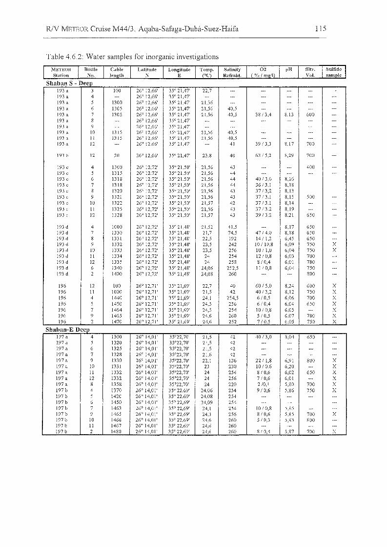
R/V METEOR Cruise M44/3, Aqaba-Safaga-Duba-Suez-Haifa 115
Table 4.6.2: Water sampIes for inorganic investigations
Sh b S Da an - eep193 a 3 100 26° 12,66' 35° 21,47' 22,7 --- --- --- --- ---193 a 4 --- 26° 12,66' 35° 21,47' --- --- --- --- --- ---193 a 5 1300 26° 12,66' 35° 21,47' 21,36 --- --- --- --- ---193 a 6 1305 26° 12,66' 35° 21,47' 21,56 40,5 --- --- --- ---193 a 7 1305 26° 12,66' 35° 21,47' 21,56 40,5 38/3,4 8,13 600 ---193 a 8 --- 26° 12,66' 35° 21,47' --- --- --- --- --- ---193 a 9 --- 26° 12,66' 35° 21,47' --- --- --- --- --- ---193 a 10 1315 26° 12,66' 35° 21,47' 21,56 40,5 --- --- --- ---193 a II 1315 26° 12,66' 35° 21,47' 21,56 40,5 --- --- --- ---193 a 12 --- 26° 12,66' 35° 21,47' --- 41 39/3,3 8,17 700 ---
193 b 12 20 26° 12,66' 35° 21,47' 23,8 40 63/5,2 8,29 700 ---
193 c 4 1300 26° 12,72' 35° 21,50' 21,56 43 --- --- 400 ---193 c 5 1315 26° 12,72' 35° 21,50' 21,56 44 --- --- --- ---193 c 6 1318 26° 12,72' 35° 21,50' 21,56 44 40/3,6 8,16193 c 7 1318 26° 12,72' 35° 21,50' 21,56 44 36/3,1 8,18193 c 8 1320 26° 12,72' 35° 21,50' 21,56 43 37/3,2 8,13193 c 9 1321 26° 12,72' 35° 21,50' 21,56 43 37/3.1 8,15 500 ---193 c 10 1322 26° 12,72' 35° 21,50' 21,57 42 37/3.1 8,14 --- ---193 c 11 1325 26° 12,72' 35° 21,50' 21,56 43 37/3.2 8,19 --- ---193 c 12 1328 26° 12,72' 35° 21,50' 21,57 43 39/3.2 8.21 650 ---
193 d 4 1000 26° 12,72' 35° 21,48' 21,52 41,5 --- 8,17 650 ---193 d 7 1330 26° 12,72' 35° 21,48' 21,7 74,5 47/4,0 8,18 650 ---193 d 8 1331 26° 12,72' 35° 21,48' 22,5 192 14/1,2 6,45 650 ---193 d 9 1332 26° 12,72' 35° 21,48' 23,5 242 10/10,8 6,09 750 X193 d 10 1333 26° 12,72' 35° 21,48' 23,5 256 10/1,0 6,04 750 X193 d II 1334 26° 12,72' 35° 21,48' 24 254 12/0,8 6,03 700 ---193 d 12 1335 26° 12,72' 35° 21,48' 24 258 8/0,4 6,01 780 ---193 d 6 1340 26° 12,72' 35° 21,48' 24,06 252,5 11/0,8 6,04 750 ---193 d 2 1400 26° 12,72' 35° 21,48' 24,08 260 --- --- 800 ---
196 12 100 26° 12,71' 35° 21,69' 22,7 40 60/5,0 8,24 600 X196 11 1000 26° 12,71' 35° 21,69' 21,5 42 40/3,2 8,12 750 X196 4 1440 26° 12,71' 35° 21,69' 24,1 254,5 6/0,5 6,06 700 X196 5 1450 26° 12,71' 35° 21,69' 24,5 256 6/0,4 6.04 650 X196 7 1464 26° 12,71' 35° 21,69' 24,5 254 10/0,8 6,05 --- X196 9 1465 26° 12,71' 35° 21,69' 24,6 260 5/0,5 6.07 780 X196 2 1470 26° 12,71' 35° 21,69' 24,6 252 7/0,5 6,05 750 X
SI b E Dla an- eep197 a 4 1300 26° 14,0 I' 35°22,70' 21,5 42 40/3,0 8,04 650 ---197 a 5 1320 26° 14,01' 35°22,70' 21,5 42 --- --- --- ---197 a 6 1325 26° 14,01' 35°22,70' 21,5 42 --- --- --- ---197 a 7 1328 26° 14,01' 35°22,70' 21,6 42 --- --- --- ---197 a 9 1330 26° 14,01' 35°22,70' 22,1 136 22/ 1,8 6,91 800 X197 a 10 1331 26° 14,01' 35°22,70' 23 230 10/0.6 6,20 --- X197 a II 1332 26° 14,01' 35°22,70' 24 254 8/0,6 6,02 650 X197 a 12 1332 26° 14,01' 35°22,70' 24 256 7/0,6 6,01 --- X197 a 8 1358 26° 14,01' 35°22,70' 24 220 2/0,1 5,80 700 X197 b 4 1370 26° 14,01' 35° 22,69' 24,06 254 9/0,6 5,86 750 X197 b 5 1420 26° 14,01' 35° 22,69' 24,08 254 --- --- --- ---197 b 6 1450 26° 14,01' 35° 22,69' 24,09 254 --- --- --- ---197 b 7 1463 26° 14,01' 35° 22,69' 24,1 254 10/0,8 5,85 --- ---197 b 9 1465 26° 14,01' 35° 22,69' 24,3 256 8/0,6 5,85 700 X197 b 10 1466 26° 14,01' 35° 22,69' 24,6 260 5/0,3 5,83 800 ---197 b 11 1467 26° 14,01' 35° 22,69' 24,6 260 --- --- --- ---197 b 2 1480 26° 14,01' 35° 22,69' 24,6 260 8/0,4 5,87 700 X
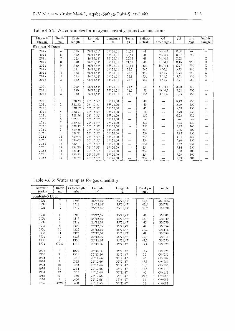
RlV J'vlETEOR Cruise M44/3, Aqaba-Safaga-Duba-Suez-Haifa 116
Table 4.6.2: Water sampies für inürganic investigatiüns (cüntinuatiün)
Sh 1 NDa )an- eep202 a 4 1300 26°15,51' 35° 20,01' 21,56 41 54/4.4 8,18 '" ...202 a 6 1320 26°15,51 ' 35° 20,01' 21,57 41 55/4,7 8,17 750 .--202 a 7 1325 26°15,51' 35° 20,01' 21,57 41 54/4,6 8,22 '" X202 a 8 1328 26°15,51 ' 35° 20,01' 21,57 40 51/4,3 8,16 750 X202 a 9 1330 26°15,51' 35° 20,01' 21,85 200 48/4,1 6,97 700 X202 a 10 1331 26°15,51' 35° 20,01' 22,7 246 5 10,3 5,73 800 X202 a 11 1332 26°15,51' 35° 20,01' 22,8 252 5/0,2 5,74 750 X202 a 12 1333 26°15,51' 35° 20,01' 22,8 250 2/0,1 5,71 650 X202 a 2 1340 26°15,51' 35° 20,01' 22,8 254 4/0,2 5,71 650 X
202 b 5 1000 26°15,51' 35° 20,0 l' 2U 50 51/4,3 8,20 750 ...202 b 12 1310 26°15,51' 35° 20,01' 21,5 50 40/4,2 8,02 700 ...202 b 2 1350 26°15,51' 35° 20,01' 22,8 255 4/0,4 5,73 750 X
202 cl 1 1328,33 26° 15,53' 35° 20,00' ... 40 ... 8,29 350 ._.
202 cl 2 1328,42 26° 15,53' 35° 20,00' ... 40 ... 8,29 200 _.-202 cl 3 1328,57 26° 15,53' 35° 20,00' _.. 42 -_. 8,28 150 ---202 cl 4 1328,71 26° 15,53' 35° 20,00' ..- 54 --- 8,20 330 ---202 cl 5 1328,86 26° 15,53' 35° 20,00' ... 150 ..- 6,33 320 -_.202 cl 6 1329,1 26° 15,53' 35° 20,00' ... '-- -_. --- --- ---202 cl 7 1329,23 26° 15,53' 35° 20,00' ..- 236 -_. 5,93 250 _..
202 cl 8 1329,42 26° 15,53' 35° 20,00' ... 250 ... 5,87 260 ---202 cl 9 1329,56 26° 15,53' 35° 20,00' ... 254 -_. 5,96 300 ._-202 cl 10 1329,71 26° 15,53' 35° 20,00' --- 254 ... 5,88 350 ...202 cl 11 1329,94 26° 15,53' 35° 20,00' ... 254 ._. 5,91 350 ---202 cl 12 1330,03 26° 15,53' 35° 20,00' ... 254 _.. 5,86 150 ...
202 cl 13 1330,11 26° 15,53' 35° 20,00' ... 254 --- 5,82 250 ..-202 cl 14 1330,26 26° 15,53' 35° 20,00' ... 254 --- 5,84 250 ..-202 cl 15 1330,41 26° 15,53' 35° 20,00' ._- 254 --- 5,80 300 ...
202 cl 16 1330,55 26° 15,53' 35° 20,00' --- 254 ._. 5,79 300 _.-202 cl 17 1330,77 26° 15,53' 35° 20,00' ... 254 ._. 5,79 300 ._-
Table 4.6,3: Water sampies für gas chemistry
LongitudcE
LatitudcN
METEORStation
Sh b S Da all- eep193a 7 1305 26°12,66' 35°21,47' 52,5 GM olme193a 12 1312 26°12,66' 35°21,47' 47,5 GM078193a 12 1312 26°12,66' 35°21,47' 38,2 GM078
193c 4 1300 26°12,66' 35°21,47' 42 GM002193c 5 1315 26°12,66' 35°21,47' 34,1 GM049193c 6 1318 26°12,66' 35°21,47' 45 GM070193c 8 1320 26°12,66' 35°21,47' 42 GM034193c 10 1322 26°12,66' 35°21,47' 36,2 GM1l6193c 11 1325 26°12,66' 35°21,47' 41 GM096193c 12 1328 26°12,66' 35°21,47' 39,7 GMOll193c 2 1330 26°12,66' 35°21,47' 43,3 GM070193c GWS 1330 26°12,66' 35°21,47' 37,4 GM098
193cl 4 1000 26°12,66' 35°21,47' 33,2 GM074193cl 7 1330 26°12,66' 35°21,47' 35 GM085193cl 8 1331 26°12,66' 35°21,47' 43 GM002193cl 9 1332 26°12,66' 35°21,47' 47,5 GM056193d 10 1333 26°12,66' 35°21.47' 51,5 GM096193cl 11 1334 26°12,66' 35°21,47' 49,5 GM010193cl 12 1335 26°12,66' 35°21,47' 66 GM053193cl 6 1340 26°12,66' 35°21,47' 49,5 GM083193cl 2 1400 26°12,66' 35°21,47' 51 GM095193d GWS 1400 26°12,66' 35°21,47' 51 GM081
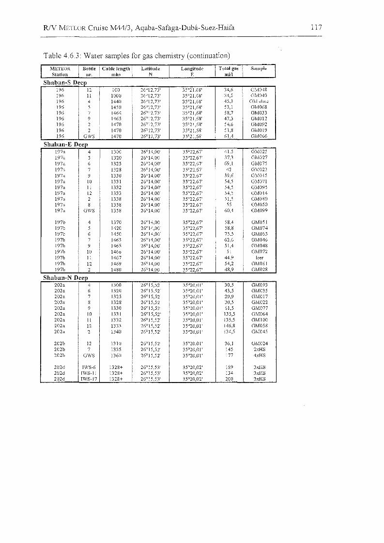
R/V METEOR Cruise M44/3, Aqaba-Safaga-Duba-Suez-Haifa 117
Table 4.6.3: Water sampIes für gas chemistry (cüntinuatiün)
LongitudeE
LatitudeN
METEORStation
Sh b S Da an- eep196 12 100 26°12.73' 35°21.68' 34,6 GM048196 11 1000 26°12,73' 35°21,68' 34,5 GM040196 4 1440 26°12,73' 35°21,68' 45,3 GM olme196 5 1450 26°12,73' 35°21,68' 53,1 GM068196 7 1464 26°12,73' 35°21,68' 58,7 GM033196 9 1465 26°12,73' 35°21,68' 47,3 GM012196 2 1470 26°12,73' 35°21,68' 54,6 GM092196 2 1470 26°12,73' 35°21,68' 51,8 GM019196 GWS 1470 26°12,73' 35°21,68' 61,4 GM066
Sh b E Da an- eep197a 4 1300 26°14,00' 35°22,67' 41,5 GM025197a 5 1320 26°14,00' 35°22,67' 37,3 GM027197a 6 1325 26°14,00' 35°22,67' 69,1 GM075197a 7 1328 26°14,00' 35°22,67' 42 GM023197a 9 1330 26°14,00' 35°22,67' 39,6 GM015197a 10 1331 26°14,00' 35°22,67' 54,5 GM071197a 11 1332 26°14,00' 35°22,67' 54,5 GM095197a 12 1333 26°14,00' 35°22,67' 54,5 GM014197a 2 1338 26°14,00' 35°22,67' 51,5 GM080197a 8 1358 26°14,00' 35°22,67' 55 GM050197a GWS 1358 26°14,00' 35°22,67' 60,4 GM099
197b 4 1370 26°14,00' 35°22,67' 58,4 GM051197b 5 1420 26°14,00' 35°22,67' 58,8 GM074197b 6 1450 26°14,00' 35°22,67' 75,5 GM065197b 7 1463 26°14,00' 35°22,67' 62,6 GM046197b 9 1465 26°14,00' 35°22,67' 51.4 GM048197b 10 1466 26"14,00' 35°22,67' 51 GMOn197b 11 1467 26°14,00' 35°22,67' 44,9 leer197b 12 1469 26°14,00' 35°22,67' 54,2 GM061197b 2 1480 26°14,00' 35°22,67' 48,9 GM028
Sh b NDa an- eep202a 4 1300 26°15,52' 35°20,01' 30,5 GM093202a 6 1320 26°15,52' 35°20,01' 43,5 GM035202a 7 1325 26°15,52' 35°20,01' 29,9 GM017202a 8 1328 26°15,52' 35°20,01' 30,5 GM022202a 9 1330 26°15,52' 35°20,01' 61,5 GM077202a 10 1331 26°15,52' 35°20,01' 135,5 GM064202a 11 1332 26°15,52' 35°20,01' 135,5 GMI00202a 12 1333 26°15,52' 35°20,01' 146,8 GM058202a 2 1340 26°15,52' 35°20,01' 134,5 GM045
202b 12 1310 26°15,52' 35°20,01' 36,1 GM024202b 7 1335 26°15,52' 35°20,01' 145 2xHS202b GWS 1360 26°15,52' 35°20,01' 177 4xHS
202d 1WS-6 1328+ 26°15,53' 35°20,02' 189 3xHS202d 1WS-ll 1328+ 26°15,53' 35°20,02' 134 3xHS202d 1WS-17 1328+ 26°15,53' 35°20,02' 200 3xHS
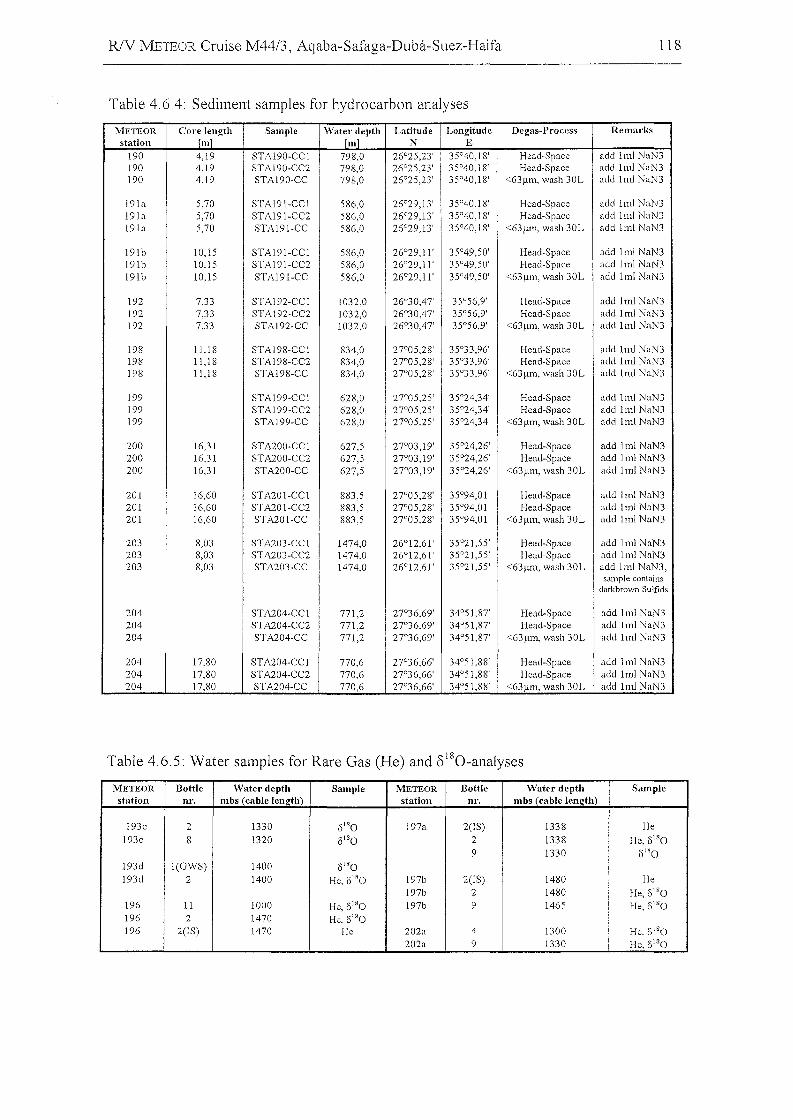
R/V METEOR Cruise M44/3, Aqaba-Safaga-Duba-Suez-Haifa
Table 4.6.4: Sediment sampIes for hydrocarbon analyses
118
METEOR Core length Sampie Watet' depth Latitude Longitude Degas-Process Remarksstation Im] Im] N E
190 4,19 STAI90-CCI 798,0 26°25,23' 35°40,18' Head-Space add Iml NaN3190 4.19 STAI90-CC2 798,0 26°25,23' 35°40,18' Head-Space add Iml NaN3190 4,19 STAI90-CC 798,0 26°25,23' 35°40,18' <63!J.m, wash 30L add Iml NaN3
191a 5,70 STAI91-CCI 586,0 26°29,13' 35°40,18' Head-Space add Iml NaN3191a 5,70 STAI91-CC2 586,0 26°29,13' 35°40,18' Head-Space add 1ml NaN3191a 5,70 STAI91-CC 586,0 26°29,13' 35°40,18' <63!J.111, wash 30L add Iml NaN3
191b 10,15 STAI91-CCI 586,0 26°29,11' 35°49,50' Head-Space add Iml NaN3191b 10,15 STAI91-CC2 586,0 26°29,11' 35°49,50' Head-Space add Iml NaN3191b 10.15 STAI91-CC 586,0 26°29,11' 35°49,50' <63!J.111, wash 30L add Iml NaN3
192 7,33 STAI92-CCI 1032,0 26°30,47' 35°56,9' Head-Space add Iml NaN3192 7,33 STAI92-CC2 1032.0 26°30,47' 35°56,9' Head-Space add Iml NaN3192 7,33 STAI92-CC 1032,0 26°30,47' 35°56,9' <63!J.111, wash 30L add Iml NaN3
198 11,18 STAI98-CCI 834,0 27°05,28' 35°33.96' Head-Space add Iml NaN3198 11,18 STAI98-CC2 834,0 27°05,28' 35°33,96' Head-Space add Iml NaN3198 11,18 STAI98-CC 834,0 27°05,28' 35°33,96' <63!J.m, wash 30L add Iml NaN3
199 STAI99-CCI 628,0 27°05,25' 35°24,34' Head-Space add Iml NaN3199 STAI99-CC2 628,0 27°05,25' 35°24,34' Head-Space add Iml NaN3199 STAI99-CC 628,0 27°05,25' 35°24,34' <63!J.m, wash 30L add Iml NaN3
200 16,31 STA200-CCI 627,5 27°03,19' 35°24,26' Head-Space add Iml NaN3200 16,31 STA200-CC2 627,5 27°03,19' 35°24,26' Head-Space add Iml NaN3200 16,31 STA200-CC 627,5 27°03,19' 35°24,26' <63!J.m, wash 30L add Iml NaN3
201 16,60 STA201-CCI 883,5 27°05,28' 35°94,01' Head-Space add Iml NaN3201 16,60 STA201-CC2 883,5 27°05,28' 35°94,0 l' Head-Space add Iml NaN3201 16,60 STA201-CC 883,5 27°05,28' 35°94,01' <63!J.m, wash 30L add Iml NaN3
203 8,03 STA203-CCI 1474.0 26°12,61' 35°21,55' Head-Space add Iml NaN3203 8,03 STA203-CC2 1474,0 26°12,61 ' 35°21,55' Head-Space add Iml NaN3203 8m STA203-CC 1474,0 26°12,61 ' 35°21,55' <63!J.1l1, wash 30L add Iml NaN3,
sampie containsdarkbrovm Sulfids
204 STA204-CCI 771,2 27°36,69' 34°51,87' Head-Space add Iml NaN3204 STA204-CC2 771,2 27°36,69' 34°51,87' Head-Space add Iml NaN3204 STA204-CC 771,2 27"36,69' 34°51,87' <63!J.1l1, wash 30L add Iml NaN3
204 17.80 STA204-CCI 770,6 27°36,66' 34°51,88' Head-Space add Iml NaN3204 17,80 STA204-CC2 770,6 27°36,66' 34°51,88' Head-Space add Iml NaN3204 17,80 STA204-CC 770,6 27°36,66' 34°51,88' <63!J.m, wash 30L add Iml NaN3
Table 4.6.5: Water sampIes for Rare Gas (He) and ol80-analyses
METEOR Bottle Watel' deptlt Sampie METEOR Bottle Waterdepth Sampiestation ur. mbs (cable lenlrth) station nr. mbs (cable length)
193c 2 1330 8'·0 197a 2(1S) 1338 He193c 8 1320 8'80 2 1338 He. 8'80
9 1330 0'80193d I(GWS) 1400 8'80193d 2 1400 He. 0'80 197b 2(1S) 1480 He
197b 2 1480 He, 8180196 11 1000 He. 8180 197b 9 1465 He, 8'80196 2 1470 He, 8'80196 2(1S) 1470 He 202a 4 1300 He. 6180
202a 9 1330 He, 8'80
R/V NLETEOR Cruise M44/3, Aqaba-Safaga-Duba-Suez-Haifa 119
4.7 Microbiology of tbe Higbly Saline Brine Sediments of tbe
Shaban Deep
(w. Eder, Lehrstuhl fur Mikrobiologie, Univ. Regensburg)
4.7.1 Introduction
To date, the microbial communities of extreme saline, anaerobic brine pools and brine
sediments of the Red Sea have been only sparsely investigated. In a first phylogenetic
approach, a brine sediment sampIe (transition zone sediment-brine) of the Kebrit Deep
showed the existence of 16S rRNA gene sequences, suggesting the presence of novel
Bacteria and Archaea (Eder et al., 1999; Eder and Huber, 1999; Stoffers et al., 1998).
For comparative phylogenetic studies, sediment sampIes of the Shaban Deep should be
taken at the transition zone, sediment-brine. Furthermore, potential extremophiles should
be identified in a polyphasie approach (e.g. enrichment and isolation, phylogenetic
staining).
4.7.2 Sampling
Together with the team of Dr. 1. Pätzold (University of Bremen) we tried to obtain
sediment sampIes from the interface between sediment and brine in the north and south
basins of the Shaban Deep by the use of a multicorer. Multicorer sampIes were obtained
from 5 stations, but the sampie material was not convincing. Nevertheless, still best and
most useable sampIe was still 3 kg of sediment taken from the multicorer METEOR
station #202g (Tab. 4.7.1), but the depth ofthe sampling site is unknown. There was no
evidence that the sediment-brine transition zone was sampled. No brine overlying the
sediment surface could be obtained at any stations.
4.7.3 SampIe Treatment
The brine sediment sampIe #202g was filled into argon-flushed 1 I Sovirel bottles, and
sealed with rubber stoppers. An aliquot of the sampie was reduced by the addition of
R/V METEOR Cnüse M44/3, Aqaba-Safaga-Duba-Suez-Haifa 120
sodium dithionite (0.05 g/100 ml), in order to remove oxygen. The sampIes were stored
at 4°C.
4.7.4 Enrichment Attempts and First Results
About 20 enrichment attempts were carried out to look for the existence of potential
extremophiles in the original sampie while still on board RV METEOR (sediment
sampIe: #202g). Brine taken from the east basin during the water-sampling program of
Prof. P. Stoffers and his colleages (University of Kiel) was used as basal medium with
CH4-C02 (95:5; v/v) and H2-C02 (80:20;v/v) as gas phase. For anaerobic conditions, the
media were reduced with 1 ml of 50% (w/v) H2S. In order to create conditions
resembling those of the natural environment, the basal medium was supplemented with
various organic and inorganic substrates (e.g., CH4, Fe3+, bacterial cell extracts) as
carbon and energy sources. The media were inoculated with 0.5 ml ofthe original sampIe
ST-51 and were incubated at 25°C. Further enrichment attempts were carried out in the
laboratory in Regensburg. No enrichment cultures were obtained from the sediment
sample after an incubation time of 60 to 75 days, in contrast to the results of the Kebrit
Deep, where halophilic procaryotes could be enriched and isolated by the use of "optical
tweezers" (Huber, 1999).
The same sediment sample was used for nucleic acid extraction and phylogenetic
analyses. From about 100 g of sediment material, small amounts of nucleic acids could be
extracted and should be used subsequently for 16S rRNA gene sequence analyses.
Table. 4.7.1: Multicorer stations for microbial studies taken in the Shaban Deep
METEOR Basin Coring device Samplingstation
202e north multicorer no surface sediment, no sampie202f north multicorer no surface sediment, no sampIe202g north multicorer surface sediment (7)203a south multicorer no surface sediment, no sampie203c south multicorer no surface sediment, no sampie
R/V METEOR Cruise M44/3, Aqaba-Safaga-Duba-Suez-Haifa 121
4.8 Organic 1\!1atter Remineralization in Carbonate and Quartz
Sands of the GuU of Aqaba, Red Sea, Jordan
(M Rasheed)
Below, we present the results obtained on the Meteor Cruise with multicores retrieved at
station GeoB 5801-2 and 5811-1.
4.8.1 Summary
Degradation of organic matter was studied in 'deep' muddy sediments in the Gulf of
Aqaba. The goal of the project was to clari±y the role of the sediment-matrix
characteristics on organic-matter-decomposition in the seabed. Sediment cores retrieved
at station GeoB 5801 and GeoB 5811 were incubated in laboratory flux chambers and
observed over time for oxygen consumption and nutrient generation. These
spectrophotometric determinations of nutrient concentrations, oxygen, and redox
potential measurements were combined in order to quanti±y the decomposition of algae
in the different sediments. Spirulina was used as algal organic material far this study.
The different sediments were incubated in flux-chambers under controlled conditions,
and the observed changes in water and pore water were used to quanti±y the
mineralization capacities ofthe sediments.
4.8.2 Introduction
The role of sediment in the degradation of organic matter and the recycling processes of
nutrients in the coastal zone has been studied intensively (e.g. Entch et al. 1983). Nixon
et al. (1980) suggested that mineralization of organic material in the sediment can be a
controlling factor for nutrient availability. Through their activities, macrobenthos
organisms that live in the sediment play an important role in mediating both physical and
chemical processes near the sediment-water interface and interstitial water including the
orgamc matter degradation processes. In deep oceanic waters a large fraction of the
argamc matter can decompose in the water column. In contrast, in shallow coastal
RlV METEOR Cruise M44/3, Aqaba-Safaga-Duba-Suez-Haifa 122
waters large proportions of the orgamc input survlve settlement through the water
column, and reach to the bottom. Ensuing decomposition of organic matter in marine
sediments can be both aerobic in the surface oxic layer and anaerobic in the anoxic
deeperlayer.
Sediments in coastal coral reef environments of tropical and subtropical zones are
composed mainly of coarse biogenic carbonates. However, coarse terrigeneous silicate
sediment can also be found in certain parts of the reef, such as valleys and troughs.
Deep-water sediments are finer and composed mainly of silts and smaller particles.
Rouband et al. (1996) found that the sediments of the Tikehau lagoon were sources of
dissolved ammonia, phosphate, and silica resulting from biogeochemical processes.
According to Fuentes and Espino (1990) and Rouband et al. (1996) a high percentage of
the ammonia and phosphate requirement for the eoral reef is supplied by remineralization
and recycling processes.
The aim of this study IS to investigate whether carbonate sediments, due to their
structure, composition, and bacterial colonization, possess different remineralization and
degradation rates for organic compounds in comparison with quartz sediments and deep
muddy sediments.
4.8.3 Material and Methods
During the cruise, sediment cores of up to 40cm length were collected from two sites at
the Jordanian side of the Gulf of Aqaba (GeoB 5801-2 from 827 m water depth,
34°54.70'E/29°24.89'N and GeoB 5811-1 from 410 m water depth, 34°
54.70'/29°24.86') using a multicorer system. The incubation of the sediment was carried
out onboard RV Meteor within half an hour of sampie collection. The core liners of the
multicorer were used as incubation chambers. The core liners were cylindrical acrylic
tubes (60cm high, 9.5cm diameter), the length ofthe sediment in the core was 40cm and
the length of the water column above the sediment was 18cm. The cores were covered
with a plastie lid with two holes. The water above the sediment was agitated using a
rotating disk of 7em diameter plaeed lOem above the sediment surface (18rpm). 0.2 g
R/V METEOR Cruise M44/3, Aqaba-Safaga-Duba-Suez-Haifa 123
dried Spirulina were added to two of the incubated cores. Another two cares were not
spiked to serve as controls. After starting the stirrer motors (12v motors), dissolved
oxygen was measured in the chamber water at different intervals by a Clark type
microelectrode. For nutrient analysis, 50ml of the supernatant water was withdrawn at
different intervals using a syringe; the volume of water withdrawn was replaced by 50ml
of the sea-water. Nutrient analyses were made in duplicates following methods
developed by Strickland and Parsons (1972), IOC Manuals and Guides (1983).
Absorption was measured in a 1 cm cell. The incubation extended over 150 hours. After
the incubation period, the water above the sediment was removed and sediment subcores
were taken and analyzed for pore water constituents. The cores were cut into slices as
thin as 1cm in the first 10cm of the sediment, and 2cm subsequently to 20cm depth of the
sediment. To extract the pore water, pieces of the sliced sediment were centrifuged
individually at 10000rpm and 4ü e. 5ml of the extracted water was filtered through
0.45/1m syringe filters. Cut-off syringes were used to remove 1ml of every sliced
sediment layer for bacteria counting, 5ml was taken far pigment analysis and 2ml for C
N analysis. SampIes for bacteria counts, pigments and C-N analyses were frozen at
80ü e.
4.8.4 Results
The course of dissolved oxygen concentration during incubation in both the spiked and
control chambers with the 800 m depth sediment is shown in Fig 4.8.1. Oxygen content
decreased gradually in the two control chambers and sharply in the Spirulina-spiked
chambers. Within the first 55 hours of incubation the dissolved oxygen concentration
went down to zero and anaerobic condition prevailed.
In the control chamber there was no significant increase or decrease in any ofthe nutrient
concentrations throughout the incubation period (Fig. 4.8.2a). At the same time, nitrite
and nitrate concentrations in the chamber with organic matter approached zero. For the
other nutrients, ammonia, phosphate and silicate, the concentrations increased gradually
with time to reach a maximum by the end of the incubation.
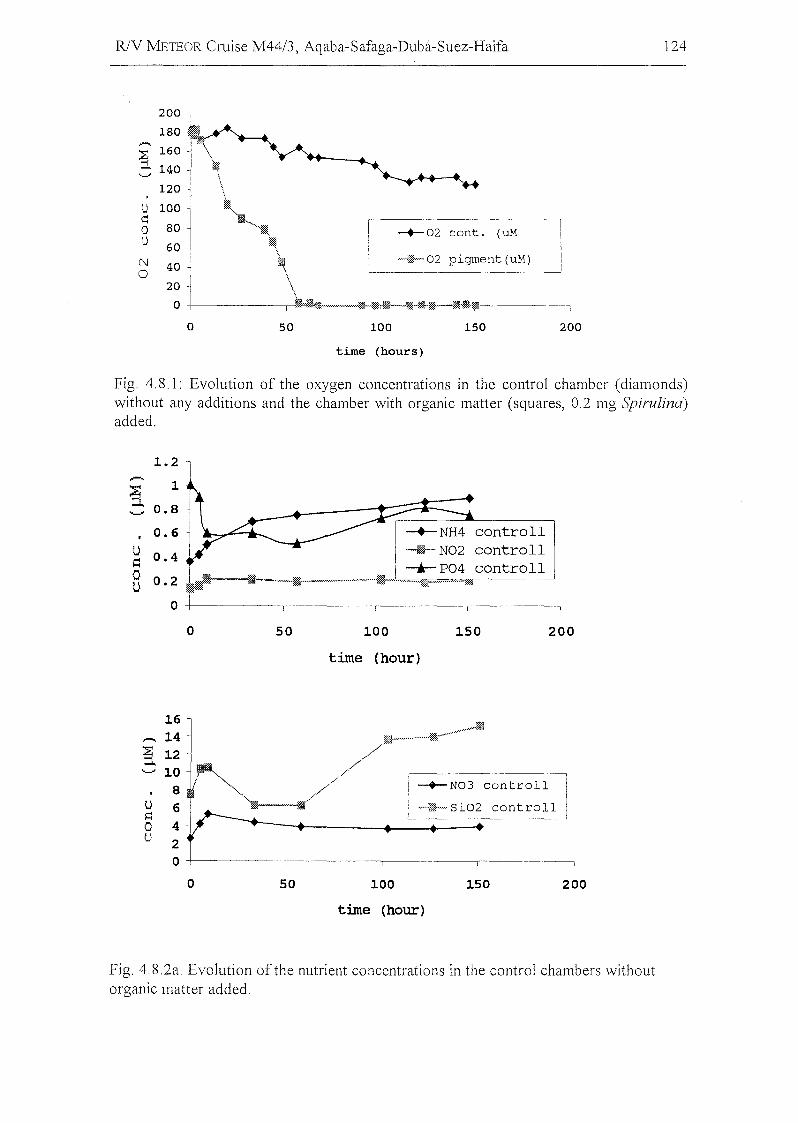
R/V METEOR Cruise M4413, Aqaba-Safaga-Dubi-Suez-Haifa 124
I --+-02 cont. (uM
l -~'02 pigment (uM)'---
o 50 100 150 200
time (hours)
Fig, 4,8,1: Evolution of the oxygen concentrations in the contral chamber (diamonds)without any additions and the chamber with organic matter (squares, 0,2 mg Spirulina)added,
1. 2 1
controllcontrollcontroll
1
0.6
g 0.4-
80.2!~~o -1- I
~'-' 0.8
o 50 100
time (hour)
150 200
u~
ou •
-+-N03 controll
--'W0~ Siü2 controll
•
o 50 100
time (hour)
150 200
Fig, 4.8,2a, Evolution ofthe nutrient concentrations in the control chambers withoutorganic matter added.
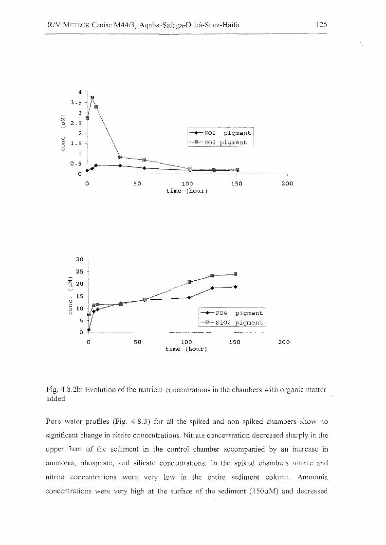
RJV METEOR Cruise M44/3, Aqaba-Safaga-Duba-Suez-Haifa
-+- N02 pigment
~ N03 pigment
125
-+-P04 pigment
-%j-- Si02 pigment
o
30
25
3. 20
uc0u
5
0
0
50
50
100time (hour)
100time (hour)
150
150
200
200
Fig. 4.8. 2b: Evolution of the nutrient concentrations in the chambers with organic matteradded.
Pore water profiles (Fig. 4.8.3) for aIl the spiked and non spiked chambers show no
significant change in nitrite concentrations. Nitrate concentration decreased sharply in the
upper 3cm of the seditnent in the contral chalnber accompanied by an increase in
ammonia, phosphate, and silicate concentrations. In the spiked chambers nitrate and
nitrite concentrations were very low in the entire sediment column. Ammonia
concentrations were very high at the surface of the sediment (150flM) and decreased
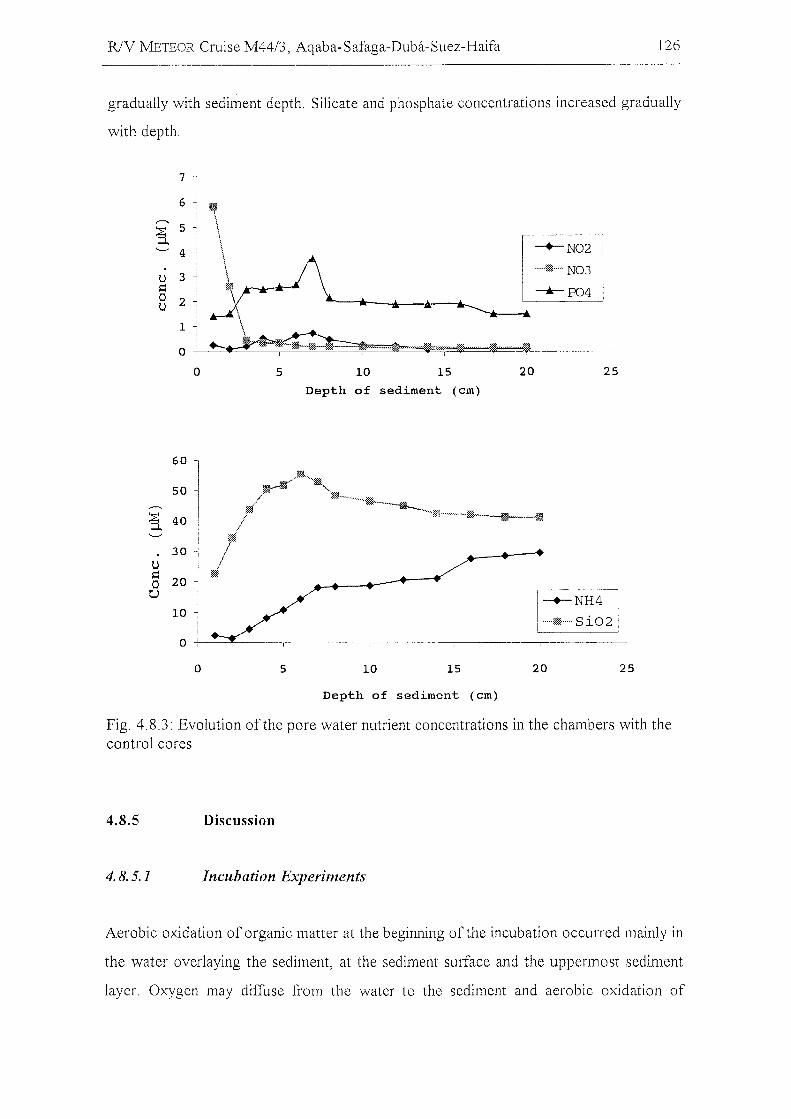
R/V IvlETEOR Cruise M44/3, Aqaba-Safaga-Duba-Suez-Haifa 126
gradually with sediment depth. Silicate and phosphate concentrations increased gradually
with depth.
o 5 10 15 20 25
Depth of sediment (ern)
-+-NH4
I~Si02,
60
50
~ 40
30U~
200U
10
0
0 5 10 15 20 25
Depth of sediment (ern)
Fig. 4.8.3: Evolution ofthe pore water nutrient concentrations in the chambers with thecontrol cores
4.8.5
4.8.5.1
Discussion
lncubation Experiments
Aerobic oxidation of organic matter at the beginning of the incubation occurred mainly in
the water overlaying the sediment, at the sediment surface and the uppermost sediment
layer. Oxygen may diffuse from the water to the sediment and aerobic oxidation of
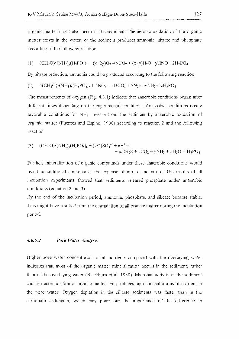
RJV METEOR Cruise M44/3, Aqaba-Safaga-Duba-Suez-Haifa 127
organic matter might also occur in the sediment. The aerobic oxidation of the organic
matter exists in the water, or the sediment produces ammonia, nitrate and phosphate
according to the following reaction
By nitrate reduction, ammonia could be produced according to the following reaction
The measurements of oxygen (Fig. 4.8.1) indicate that anaerobic conditions began after
different times depending on the experimental conditions. Anaerobic conditions create
favorable conditions for NH4+ release from the sediment by anaerobic oxidation of
organic matter (Fuentes and Espino, 1990) according to reaction 2 and the following
reaction
(3) (CH20)o(NH3)y(H3P04)z + (x/2)S04-2 + xH+ == x/2H2S + xC02 + yNH3 + xH20 + H 3P04
Further, mineralization of organic compounds under these anaerobic conditions would
result in additional ammonia at the expense of nitrate and nitrite. The results of all
incubation experiments showed that sediments released phosphate under anaerobic
conditions (equation 2 and 3).
By the end of the incubation period, ammonia, phosphate, and silicate became stable.
This might have resulted from the degradation of all organic matter during the incubation
period.
4.8.5.2 Pore Water Analysis
Higher pore water concentration of all nutrients compared with the overlaying water
indicates that most of the organic matter mineralization occurs in the sediment, rather
than in the overlaying water (Blackburn et al. 1988). Microbial activity in the sediment
causes decomposition of organic matter and produces high concentrations of nutrient in
the pore water. Oxygen depletion in the silicate sediments was faster than in the
carbonate sediments, which may point out the importance of the difference in
RlY METEOR Cruise M44/3, Aqaba-Safaga-Duba-Suez-Haifa 128
composition and diffusion rate in the two sediment types. The gradient in the pore water
in the control ehambers in all nutrient eoneentrations other than nitrate and nitrite from
bottom water into the sediment might be attributed to the organie matter degradation
and dissolution under anoxie eondition. The low eoncentrations of nitrate and nitrite in
the core with added pigment are due to anaerobie nitrate reduction (see equation 2
above). The relatively higher ammonia concentrations in the first 2cm depth of the
sediments in the cruise sediment ineubation ean be attributed to the liberation of
ammonia from the water column in addition to the sediment liberation. Performing
complementary experiments with different methods will help to explore other features of
organie carbon decomposition in both carbonate and silicate sediments. Gur long-term
objective is to model the organic carbon and nutrient flux in different types of marine
sediments.
R/V METEOR Cruise M44/3, Aqaba-Safaga-Duba-Suez-Haifa
4.9 Meteorological Conditions during RN lVIETEOR Cruise M44/3
CD. Bassek, DWD, Hamburg)
129
R/V METEOR left Aqaba on the 12th ofMarch at 10:00 hours with moderate northerly
winds and a temperature of about 20°e. The scientific work in the Gulf of Aqaba was
done under good weather conditions and a poor cloudiness. The winds blowed daily
from nOliherly directions with windspeeds between 0.5 and 26 knots. The average wind
speed during the cruise in Gulf of Aqaba was about 20 knots from northerly directions.
Due to the short fetch of about 100 km, the maximum windsea was about 1.5 meter. The
temperatures cooled to 13°C in the morning and rose up to 22°C in the afternoon.
In the area of the Red Sea, the scientific work was also performed under good weather
conditions and with windspeeds between 0 and 40 knots. The average wind speed during
this cruise was about 20 knots from northwesterly to northerly directions. Only on one
day did the wind reach velocities of 40 to 43 knots. The maximum wind sea was about 2
meters. To be precise, it was 16% 0 Meter, 55% 1 Meter, 29% 2 Meter. The
temperatures were between 24°C and 26°C during the whole day with humidity from
30% to 90%. The visibility was good most of the time good, on other days it was dusty.
Scientific work in the Eastern Mediterranean Sea onr the last 2 days was also done under
weather conditions.
Synoptic situation during Leg M44/3: After starting this leg at Aqaba, the anticyclone
over the eastern part of the Mediterranean Sea caused mostly northerly winds in the Gulf
of Aqaba. The strongest winds were noticed in the morning hour's bft 5 to 6 with gusts
up to bft 7 sometimes. Because of sunny conditions, sea breeze effects took place during
the afternoon. On 18.03.99 a low passed the eastern Mediterranean Sea from west to
east. Therefore winds in the Gulf of Aqaba turned right to SE but very weak in force. On
22.03.99 the anticyclone influence west of Aqaba increased again. Winds from NW to
NE Bft 4 to 6 were recorded onboard. On 30.03.99 light winds were registered due to
small pressure gradients in the operating area. On 31.03.99 heavy northwesterly winds
were noticed enroute at the rear of a low with maximum winds near bft 9 far some
hours. After leaving Port Said, winds from NW to E took place mostly moderate to
strong in force.
R/V METEOR Cruise M44/3, Aqaba-Safaga-Duba-Suez-Haifa 130
5 References
Blackbum, T. H. B. Lund, Aa., Konn, M. D. (1988). C- and N-mineralization in the sediments ofearthen marine fishponds. iv/ar. Ecol. ProgI'. SeI'. 44,221-227.
Eder, W., and Huber, R (1999). Recovery of novel procaryotic rRNA sequences from low-temperature,saline brine sediments of Kebrit Deep, Red Sea. Meeresforschung mit FS Sonne, Statusseminar 10.12.03.99 in Freiberg, Bundesministerium für Bildung und Forschung, Rostock-Warnemünde,Gennany.
Eder, W., Ludwig, W" and Huber, R (1999). Novel 16S rRNA gene sequences retrieved from highlysaline brine sediments ofKebrit Deep, Red Sea. Arch. Microbiol. 172,213-218.
Entch B., Boto, K. G., Sim, R. G., and Wellington, 1. T. (1983). Phosphorous and nitrogen in coral reefsediments. Limnol. Oceanogr. 28, 465-467.
Ericson, D. B., and Wollin, G. (1968). Pleistocene climates and chronology in deep-sea sediments.Science 162, 1227-1234.
Faber, E., Botz, R, Poggenburg, J. Schmidt, M., Stoffers, P., and Hartmann, M. (1998). Methane in RedSea brines. Organic Geochemistry 29,363-379.
Fuentes, A, and Espino, L. (1990). Metabolisll1 as determination of nutrient exchange in organic-richsediments of a coastallagoon. Ciencias Marinas 16(3), 45-62.
Graham, G., and Mazzullo, 1. (1988). Handbook for Shipboard Sedimentologists. ODP Technical NoteNI. 9.
Hartmann, M., Scholten, 1., Stoffers, P., and Wehner, F. (1998). Hydrographic structure of brine-filleddeeps in the Red Sea - new results from the Shaban, Kebrit, Atlantis Ir, and Discovery Deep.Marine Geology 144,311-330.
Hemleben, c., Meischner, D., Zahn, R, Almogi-Labin, A, Erlenkeuser, H., and Hiller, B. (1996). Threehundred eighty thousand year long stable isotope and faunal records from the Red Sea: Influence ofglobal sea level change on hydrography. Paleoceanography 11, 147-156.
Huber, R (1999). Die Laserpinzette als Basis für Einzelzellkultivierung. Biospektrum 4, 289-291.
IOC Manuals and Guides (1983). Chemical methods for use in marine environmental monitoring,UNESCO, 12, pp. 53.
Mix, AC., Rugh, W., Pisias, N. G., and Veirs, S. (1992). Color reflectance spectroscopy: A tool forrapid characterization of deep-sea sediment. In "Proceedings of the Ocean Drilling Project, InitialReport 138." (I. Mayer, N. G. Pisias, and T. e. a. Janecek, Eds.).
Nixon., S. W., Kelly, 1. R., Pumas, B. N., Oviatte, C. A, and Haie, S. S. (1980). Phosphorusregeneration and the metabolism of coastal marine bottom communities. In: K.R. Tenore and B. CCoull (eds). A1arine Benthic Dynamics, University of South Carolina Press, Columbia, pp. 219-242.
Reiss, Z., and Hottinger, L. (1984). "The Gulf of Aqaba (Elat)." Springer-Verlag, Berlin, 330 p.
Reiss, Z., Luz, B., Almogi-Labin, A, Halicz, E., Winter, A, and Wolf, M. (1980). Late quaternarypaleoceanography of the Gulf of Aqaba (Elat), Red Sea. Quaternary Research 14,294-308.
Roubaud. c., Charpy, L., and Sarazin., G. (1996). Diffusional nutrient fluxes at the sediment-waterinterface and organic matter mineralization in an atoll lagoon (Tihehau, Tuamotu archipelago,French Polynesia). Mal'. Ecol. ProgI'. SeI'. 132, 181-190.
Spieß, V. (1993). Digitale Sedimentechographie - Neue Wege zu einer hochaufläsendenAkustostratigraphie. Berichte, Fachbereich Geowissenschaften, Universität Bremen 35, 199 p.
Stoffers, P., and cruise paJ1icipants (1998). Cruise report SONNE 121, Red Sea. Hydrography,hydrothennalism, and palaeoceanography in the Red Sea. NI. 88. Geologisch-PaläontologischesInstitut der Universität Kiel, Kiel, Germany.
Strickland., J., and Parsons, T. (1968). A particular hand book of sea water analysis. pp. 67-311.
R/Y METEOR Cruise M44/3, Aqaba-Safaga-Dubä-Suez-Haifa 131
6 Acknowledgements
The scientific party aboard R/Y IvIETEOR during Leg 3 of Cruise No. 44 gratefully
acknowledges the friendly cooperation and efficient technical assistance of Captain
S. Bülow, his officers and crew, who substantially contributed to the overall scientific
success of this cruise.
Special thanks go to the Federal Foreign Office in Bonn and the German Embassies at
Cairo, at Riad, at Amman, and at Tel Aviv for the support to achieve permissions to
carry out research in Egyptian, Saudi Arabian, Jardanian, and Israeli waters.
We also appreciate the most valuable help of the Leitstelle METEOR, Hamburg and the
ship's managing owner, the RF "Reedereigemeinschaft Forschungsschiffahrt GmbH",
Bremen in the planning and realization ofthe cruise.
The wark was funded by the Deutsche Forschungsgemeinschaft grants no. PA 492/2-1,
PA 492/3-1, and PA 492/3-2.
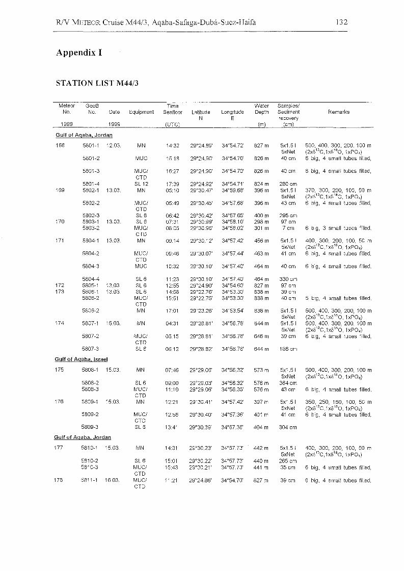
R/V METEOR Cruise M44/3, Aqaba-Safaga-Duba-Suez-Haifa
Appendix I
132
STATION LIST M44/3
Meteor GeoB rime Water Samples/No. No. Date Equipment Seafloor Latitude Longitude Depth Sediment Remarks
N E recovery1999 1999 (UrC) (m) (em)
Gulf of Agaba, Jordan
168 5801-1 12.03. MN 14:32 29°24.89' 34°54.72' 827 m 5x1.51 500, 400, 300, 200, 100 m5xNet (2xo13C,1 X0180, 1xP0 4)
5801-2 MUC 1518 29°24.90' 34°54.70' 826 m 40 cm 6 big, 4 small tubes filled,
5801-3 MUCI 16:27 29°24.90' 34°54.70' 826 m 40 em 6 big, 4 small tubes filled,crD
5801-4 SL12 17:39 29°24.92' 34°54.71' 824m 280 cm169 5802-1 13.03. MN 05:10 29°30.47' 34°59.68' 396 m 5x1.51 370, 300, 200, 100, 50 m
5xNet (2xo13C,1 X0180, 1xP0 4)
5802-2 MUCI 05:49 29°30.45' 34°57.68' 396 m 43 cm 6 big, 4 small tubes filled,CTD
5802-3 SL 6 06:42 29°30.42' 34°57.65' 400 m 295 cm170 5803-1 13.03. SL 6 07:31 29°30.99' 34°58.10' 298 m 97 cm
5803-2 MUCI 08:05 29°30.96' 34°58.02' 301 m 7cm 6 big, 3 small tubes filled,CrD
171 5804-1 13.03. MN 09:14 29°30.12' 34°57.42' 456 m 5x1.51 400, 300, 200, 100, 50 m5xNet (2xo13C,1xo180, 1xP0 4)
5804-2 MUCI 09:46 29°30.07' 34°57.44' 463m 41 cm 6 big, 4 small tubes filled,CrD
5804-3 MUC 1032 29°30.10' 34°57.40' 464 m 40 cm 6 big, 4 small tubes filled,
5804-4 SL 6 11:23 29°30.10' 34°57.40' 464m 330cm172 5805-1 13.03. SL 6 12:55 29°24.90' 34°54.60' 827m 97 cm173 5806-1 13.03. SL 6 14:58 29°22.76' 34°53.30' 838 m 39 cm
5806-2 MUCI 15:51 29°22.75' 34°53.30' 838 m 40 cm 5 big, 4 small tubes filled,CTD
5806-2 MN 17:01 29°23.26' 34°53.54' 838 m 5x1.51 500, 400, 300, 200, 100 m5xNet (2xo13C,1 X0 180, 1xP04)
174 5807-1 15.03. MN 04:31 29°28.81 ' 34°56.78' 644m 5x1.51 500, 400, 300, 200, 100 m5xNet (2xo13C,1 X0180, 1xP04)
5807-2 MUCI 0515 29°28.81 ' 34°56.78' 646 m 39 em 6 big, 4 small tubes filled,CTD
5807-3 SL 6 06:12 29°28.82' 34°56.76' 644m 186em
Gulf of Agaba, Israel
175 5808-1 1503. MN 07:46 29°29.06' 34°56.32' 573 m 5x1.5l 500, 400, 300, 200, 100 m5xNet (2xo13C,1x0 180, 1xP04)
5808-2 SL 6 09:00 29°29.03' 34°56.32' 578 m 364em5808-3 MUCI 11:10 29°29.06' 34°56.35' 576 m 43 em 6 big, 4 sm<!ll tubes filled,
CrD176 5809-1 15.03. MN 12:21 29°30.41 ' 34°57.42' 397 m 5x1.5l 350, 250, 150, 100, 50 m
5xNet (2xo13C,1 X0180, 1xP04)
5809-2 MUCI 12:56 29°30.40' 34°57.36' 401 m 41 em 6 big, 4 small tubes filled,CTD
5809-3 SL 6 13:41 29°30.39' 34°57.36' 404m 304em
Gulf of Agaba, Jordan
177 5810-1 15.03. MN 14:31 29°30.23' 34°57.73' 442m 5x1.51 400, 300, 200, 100, 50 m5xNet (2xo13C,1xo180,1xP04)
5810-2 SL 6 15:01 29°30.22' 34°57.73' 440m 265 em5810-3 MUCI 15:43 29°30.21' 34°57.73' 441 m 35 em 6 big, 4 small tubes filled,
CTD178 5811-1 16.03. MUCI 11 :21 29°24.86' 34°54.70' 827 m 39 em 6 big, 4 small tubes filled,
CrD
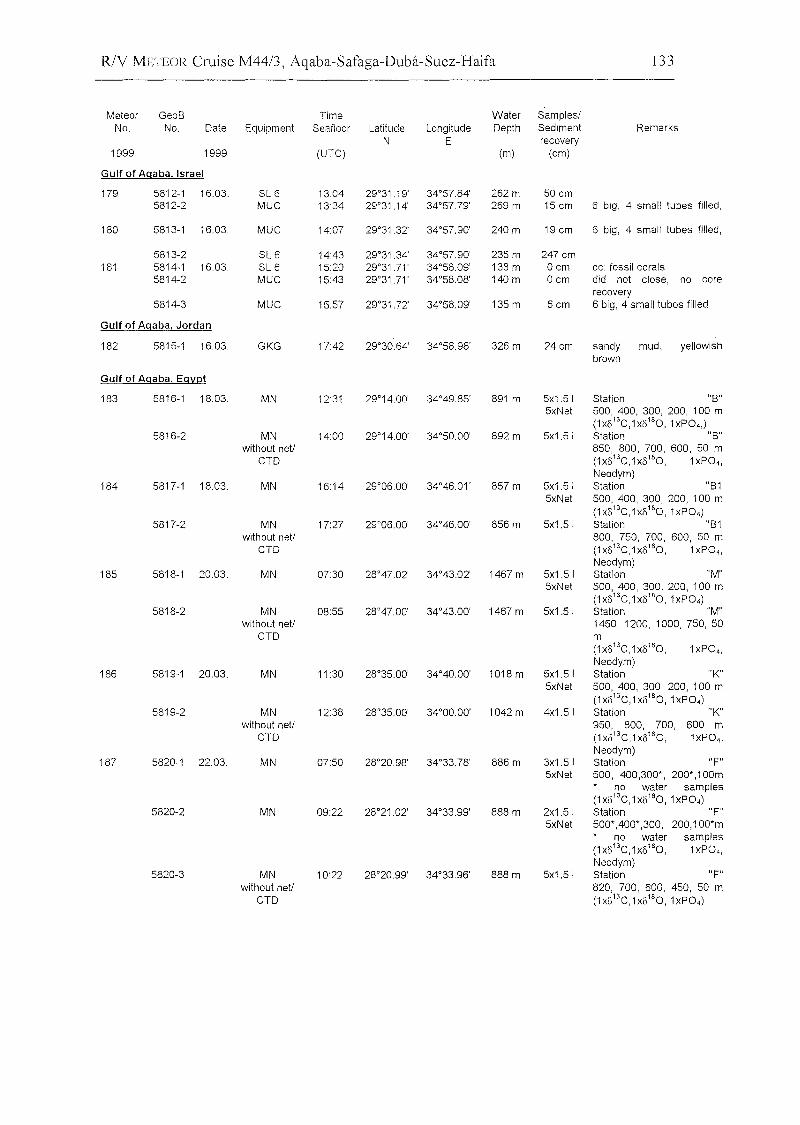
R/Y :LvlETEOR Cruise M44/3, Aqaba-Safaga-Duba-Suez-Haifa 133
Meteor GeoB Time Water SampleslNo. No. Date Equipment Seafloor Latitude Longitude Depth Sediment Remarks
N E recovery1999 1999 (UTe) (m) (cm)
Gulf of Agaba. Israel
179 5812-1 16.03. SL 6 13:04 29°31.19' 34°57.84' 262 m 50 cm5812-2 MUe 13:34 29°31.14' 34°57.79' 269 m 15 cm 6 big, 4 small tubes filled,
180 5813-1 16.03. MUe 14:07 29°31.32' 34°57.90' 240m 19 cm 6 big, 4 small tubes filled,
5813-2 SL 6 14:43 29°31.34' 34°57.90' 235 m 247 cm181 5814-1 16.03. SL6 15:20 29°31.71 ' 34°58.09' 138 m Ocm cc: fossil corals
5814-2 MUe 15:43 29°31.71' 34°58.08' 140m ocm did not close, no corerecovery
5814-3 MUe 15:57 29°31.72' 34°58.09' 135 m 6cm 6 big, 4 small tubes filled
Gulf of Agaba, Jordan
182 5815-1 16.03. GKG 17:42 29°30.64' 34°58.98' 326 m 24cm sandy mud, yellowishbrown
Gulf of Agaba, Egypt
183 5816-1 18.03. MN 12:31 29°14.00' 34°49.85' 891 m 5x1.51 Station "8"5xNet 500, 400, 300, 200, 100 m
(1xü13
e,1xü18O,1xP04')5816-2 MN 14:00 29°14.00' 34°50.00' 892 m 5x1.51 Station "B lI
without netl 850, 800, 700, 600, 50 meTD (1xü 13e,1xü180, 1xP04,
Neodym)184 5817-1 18.03. MN 16:14 29°0600' 34°46.01 ' 857 m 5x1.51 Station "B1
5xNet 500, 400, 300, 200, 100 m(1xü13e,1xü180,1xP04)
5817-2 MN 17:27 29°06.00' 34°46.00' 856 m 5x1.51 Station "B1without netl 800, 750, 700, 600, 50 m
eTD (1xü 13e,1xü180, 1xP04,Neodym)
185 5818-1 20.03. MN 07:30 28°47.02' 34°43.02' 1467m 5x1.51 Station "M"5xNet 500, 400, 300, 200, 100 m
(1xü13e,1xü180,1xP04)5818-2 MN 08:55 28°47.00' 34°43.00' 1467 m 5x1.51 Station "M"
without netl 1450, 1200, 1000, 750, 50eTD m
(1xü 13e ,1XÜ 180, 1xP04,Neodym)
186 5819-1 20.03. MN 11 :30 28°35.00' 34°40.00' 1018m 5x1.51 Station "K"5xNet 500, 400, 300, 200, 100 m
(1xü13e,1 XÜ180, 1xP04)
5819-2 MN 12:38 28°35.00' 34°0000' 1042m 4x1.51 Station "K"without netl 950, 800, 700, 600 m
eTD (1 xü13e, 1XÜ180, 1xP04,
Neodym)187 5820-1 22.03. MN 07:50 28°20.98' 34°33.78' 886 m 3x1.51 Station "F"
5xNet 500, 400,300*, 200',1 OOmno water sampies
(1xü13e,1x8180,1xP04)5820-2 MN 09:22 28°21.02' 34°33.99' 888 m 2x1.51 Station "F"
5xNet 500*,400*,300, 200,100*mno water sampies
(1xü13e,1xü180, 1xP04,Neodym)
5820-3 MN 10:22 28°20.99' 34°33.96' 888 m 5x1.51 Station "F"without netl 820, 700, 600, 450, 50 m
eTD (1xü13e,1xü180,1xP04)
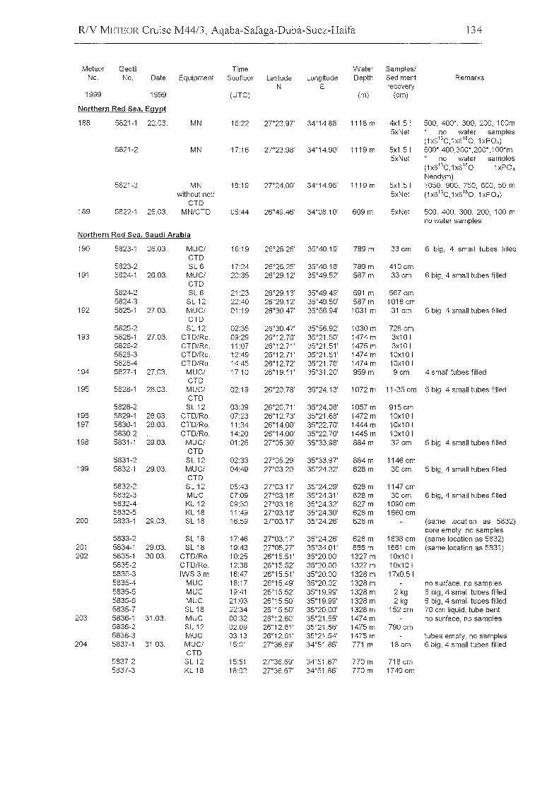
R/Y METEOR Cruise M44/3, Aqaba-Safaga-Duba-Suez-Haifa 134
Meteor GeaB Time Water Samples/No, No, Date Equipment Seaflaar Latitude Langitude Depth Sediment Remarks
N E recovery1999 1999 (UTC) (m) (em)
Narthern Red Sea, Egypt
188 5821-1 22,03, MN 16:22 27"23,97' 34°14,88' 1118 m 4x1,51 500, 400*, 300, 200, 100m5xNet na water sampies
(1x613C,1x6'80 ,1xP04)
5821-2 MN 1716 2T23,98' 34°14,90' 1119 m 5x1,51 500* ,400,300* ,200*,1 OO*m5xNet na water sampies
(1x6 13C,1x6180, 1xP04
Neodym)5821-3 MN 18:19 27"24,00' 34°14.96' 1119 m 5x1,51 1050, 900, 750, 600, 50 m
withaut neU 5xNet (1x6'3C,1x818O,1xP04 )
CTD189 5822-1 25,03, MN/CTD 05:44 26°49.46' 34°08,10' 609 m 5xNet 500, 400, 300, 200, 100 m
na water sampies
Northern Red Sea, Saudi Arabia
190 5823-1 26,03, MUC/ 16:19 26°25,26' 35°40,19' 789 m 33 em 6 big, 4 small tubes filledCTD
5823-2 SL 6 17:24 26°25,25' 35°40,18' 789m 410em191 5824-1 26,03, MUC/ 20:35 26°29,12' 35°49,52' 587 m 33 em 6 big, 4 small tubes filled
CTD5824-2 SL 6 2123 26°29,13' 35°49.49' 591 m 567 em5824-3 SL12 22:40 26°29,12' 35°49,50' 587 m 1016 em
192 5825-1 27,03, MUC/ 01:19 26°30.47' 35°56,94' 1031 m 31 em 5 big, 4 small tubes filledCTD
5825-2 SL12 02:35 26°30.47' 35°56,92' 1030 m 728 em193 5826-1 27,03, CTD/Ra, 09:29 26°12,70' 35°21,50' 1474m 3x10 I
5826-2 CTD/Ra, 11:07 26°12,71 ' 35°21,51 ' 1475 m 3x10 I5826-3 CTD/Ra, 12:49 26°12,71' 35°21,51 ' 1474 m 1Ox10 I5826-4 CTD/Ra, 14:45 26°12,72' 35°21,78' 1474m 10x10 I
194 5827-1 27,03, MUC/ 1710 26°19,11 ' 35°31,20' 959 m 9 em 4 small tubes filledCTD
195 5828-1 28,03, MUC/ 02:19 26°20,78' 35°24,13' 1072 m 11-35 em 5 big, 4 small tubes filledCTD
5828-2 SL12 03:39 26°20,71' 35°24,08' 1057m 915 em196 5829-1 28,03, CTD/Ra, 07:23 26°12,73' 35°21,68' 1472m 10x10 I197 5830-1 28,03, CTD/Ra, 11 :34 26°14,00' 35°22,70' 1444m 10x10 I
5830-2 CTD/Ra, 14:20 26°14,00' 35°22,70' 1445 m 10x10 I198 5831-1 29,03, MUC/ 01:25 2T05,30' 35°33,98' 884m 32 em 5 big, 4 small tubes filled
CTD5831-2 SL12 02:33 2T05.29' 35°33,97' 884 m 1146 em
199 5832-1 29,03, MUC/ 04:49 2T03.20' 35°24,32' 628 m 30em 5 big, 4 small tubes filledCTD
5832-2 SL12 05:43 2T03,17' 35°24,29' 628 m 1147 em5832-3 MUC 07:09 2T03,18' 35°24,31' 628m 30 em 6 big, 4 small tubes filled5832-4 KL 12 09:30 2T03,18' 35°24,32' 627 m 1090 em5832-5 KL18 11 :49 27"03,18' 35°24,30' 628m 1660 em
200 5833-1 29,03, SL18 16:59 27"03,17' 35°24,26' 628 m (same laeatian as 5832)eore empty, no sampies
5833-2 SL18 17:46 2T03,17' 35°24,26' 628 m 1638 em (same laeation as 5832)201 5834-1 29,03, SL18 19:43 27"05.27' 35°34,01 ' 886 m 1661 em (same loeatian as 5831)202 5835-1 30,03, CTD/Ra, 10:25 26°15,51 ' 35°20,00' 1327 m 10x10 I
5835-2 CTD/Ro, 12:38 26°15,52' 35°20,00' 1327 m 10x10 I5835-3 IWS3m 16:47 26°15,51 ' 35°20,00' 1328m 17xO,515835-4 MUC 18:17 26°15.49' 35°20,02' 1328 m no surface, no sampies5835-5 MUC 19:41 26°15,52' 35°19,99' 1328 m 2 kg 6 big, 4 small tubes filled5835-6 MUC 21:03 26°15,50' 35°19,99' 1328 m 2 kg 6 big, 4 small tubes filled5835-7 SL18 22:34 26°15,50' 35°20,00' 1328m 152 em 70 em liquid, tube bent
203 5836-1 31,03, MUC 00:32 26°12,60' 35°21,55' 1474m na surfaee, no sampies5836-2 SL12 02:09 26°12,61 ' 35°21,56' 1475 m 790em5836-3 MUC 03:13 26°12,61 ' 35°21,54' 1475 m tubes empty, na sampies
204 5837-1 31,03, MUC/ 15:01 27"36,69' 34°51,85' 771 m 18 em 6 big, 4 small tubes filledCTD
5837-2 SL12 15:51 2T36,69' 34°51,87' 770m 718 em5837-3 KL18 18:02 2T36,67' 34°51,86' 770m 1740 em
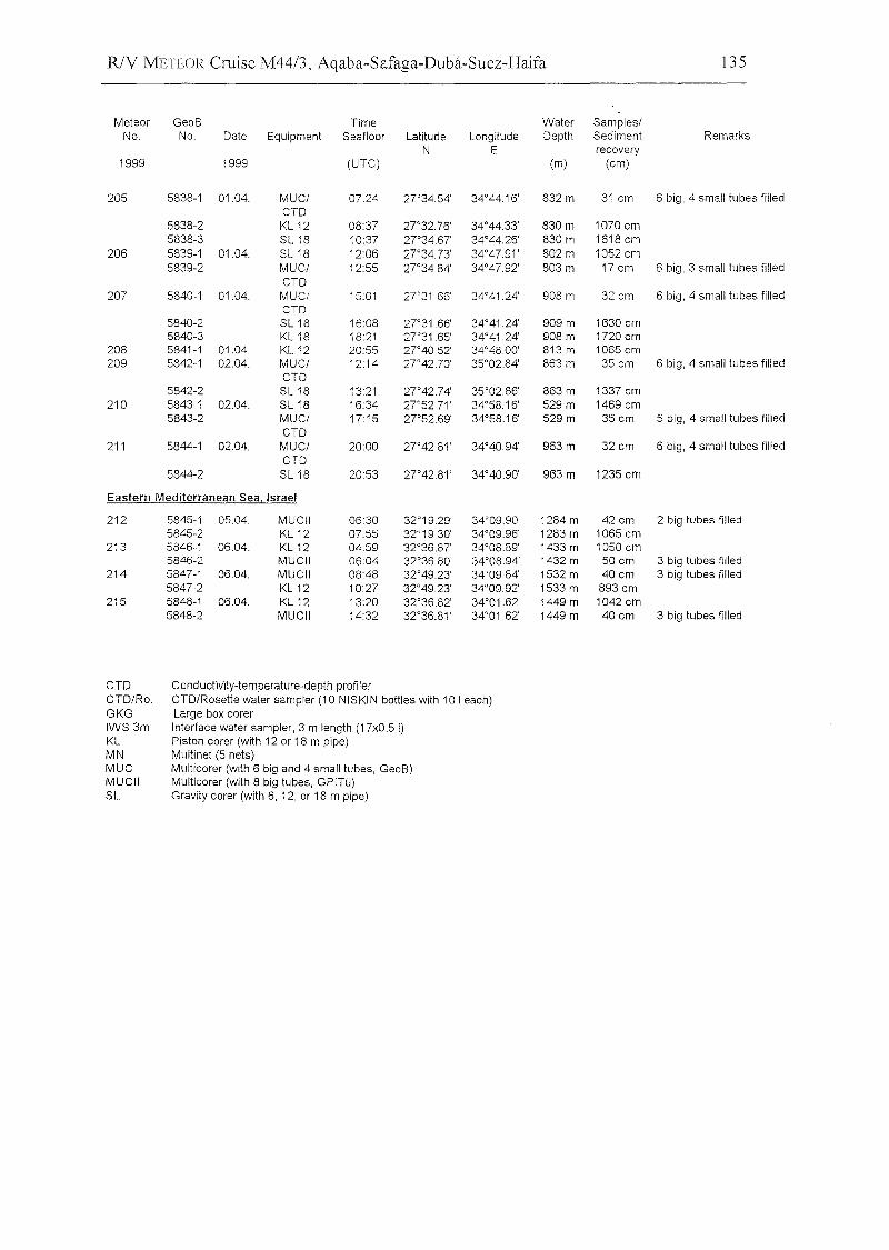
R/Y METEOR Cruise M44/3, Aqaba-Safaga-Duba-Suez-Haifa 135
Meteor GeoB Time Water Samples/No. No. Date Equipment Seafloor Latitude Longitude Depth Sediment Remarks
N E recovery1999 1999 (UTC) (m) (cm)
205 5838-1 01.04. MUC/ 07:24 2]034.54' 34°44.16' 832 m 31 cm 6 big, 4 small tubes filledCTD
5838-2 KL 12 08:37 2]032.76' 34°44.33' 830 m 1070 cm5838-3 SL18 10:37 27"3467' 34°4426' 830 m 1618 cm
206 5839-1 01.04. SL18 12:06 27"34.73' 34°47.91 ' 802 m 1052 cm5839-2 MUC/ 12:55 27"34.84' 34°4792' 803 m 17cm 6 big, 3 small tubes filled
CTD207 5840-1 01.04. MUC/ 15:01 27"31.66' 34°41.24' 908 m 32 cm 6 big, 4 small tubes filled
CTD5840-2 SL18 16:08 2]031.66' 34°41.24' 909 m 1630 cm5840-3 KL18 18:21 2]031.65' 34°41.24' 908 m 1720 cm
208 5841-1 01.04. KL 12 20:55 27"40.52' 34°48.00' 813 m 1065 cm209 5842-1 02.04. MUC/ 12:14 27"42.70' 35°02.84' 863 m 35 cm 6 big, 4 small tubes filled
CTD5842-2 SL18 13:21 27"42.74' 35°02.86' 863 m 1337 cm
210 5843-1 02.04. SL18 16:34 27"52.71' 34°5816' 529m 1469 cm5843-2 MUC/ 17:15 2]052.69' 34°58.16' 529 m 35 cm 5 big, 4 small tubes filled
CTD211 5844-1 02.04. MUC/ 20:00 27"42.81' 34°40.94' 963 m 32 cm 6 big, 4 small tubes filled
CTD5844-2 SL18 20:53 27"42.81' 34°40.90' 963 m 1235 cm
Eastern Mediterranean Sea, Israel
212 5845-1 05.04. MUCII 06:30 32°19.29' 34°09.90' 1284m 42 cm 2 big tubes filled5845-2 KL 12 07:55 32°19.30' 34°09.96' 1283 m 1065 cm
213 5846-1 0604. KL 12 04:59 32°36.87' 34°08.89' 1433 m 1050 cm5846-2 MUCII 06:04 32°36.80' 34°08.94' 1432 m 50 cm 3 big tubes filled
214 5847-1 06.04. MUCII 08:48 32°49.23' 34°09.84' 1532 m 40 cm 3 big tubes filled5847-2 KL 12 10:27 32°4923' 34°09.92' 1533 m 893 cm
215 5848-1 06.04. KL 12 13:20 32°36.82' 34°01.62' 1449m 1042 cm5848-2 MUCII 14:32 32°36.81 ' 34°01.62' 1449m 40cm 3 big tubes filled
CTDCTD/Ro.GKGIWS3mKLMNMUCMUCIISL
Conductivity-temperature-depth profilerCTD/Rosette water sampier (10 NISKIN bottles with 101 each)Large box corerInterface water sampier, 3 m length (17xO.5 I)Piston corer (with 12 or 18 m pipe)Multinet (5 nets)Multicorer (with 6 big and 4 small tubes, GeoB)Multicorer (with 8 big tubes, GPITü)Gravity corer (with 6, 12, or 18 m pipe)