Embed Size (px)
Citation preview
ESA Living Planet Symposium, Bergen, 29.6.2010
T. Gruber, C. Ackermann, T. Fecher, M. HeinzeInstitut für Astronomische und Physikalische Geodäsie (IAPG)
Technische Universität München
P. VisserDepartment of Earth Observation and Space Systems (DEOS)
Delft University of Technology
Validation of GOCE Gravity Field Models
and Precise Science Orbits
ESA Living Planet Symposium, Bergen, 29.6.2010
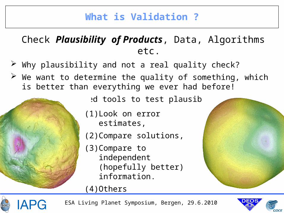
What is Validation ?
Check Plausibility of Products, Data, Algorithms etc. Why plausibility and not a real quality check?
We want to determine the quality of something, which is better than everything we ever had before!
For this we need tools to test plausibility. What are such tools?
(1) Look on error estimates,
(2) Compare solutions,
(3) Compare to independent (hopefully better) information.
(4) Others
ESA Living Planet Symposium, Bergen, 29.6.2010
Example for Plausability – Role of Reference Data
ESA Living Planet Symposium, Bergen, 29.6.2010
Outline of Talk
1. GOCE Orbit Validationa) Compare Orbit Positions and Velocities from different Solutions
b) Residuals to independent Observations (e.g. SLR)
2. GOCE Gravity Field Validationa) Results of Least-Squares Adjustment: Signals and Errors
b) Error Propagation (Variances & Co-variances)
c) Orbit Residuals
d) Geoid Comparisons
e) Sea Surface Topography (Level 3) (not shown here)
ESA Living Planet Symposium, Bergen, 29.6.2010
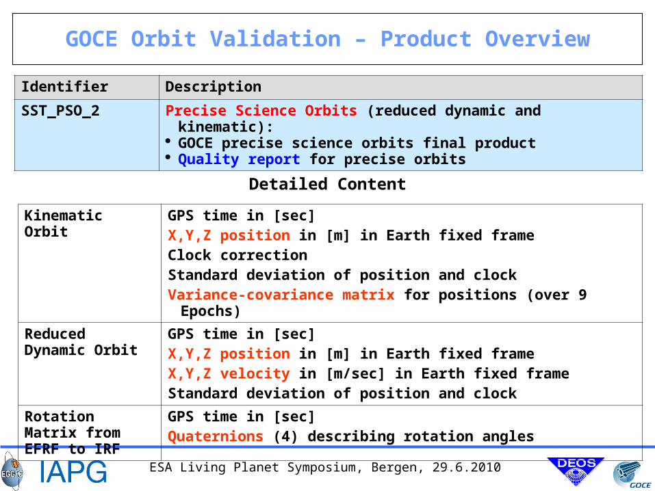
GOCE Orbit Validation – Product Overview
Identifier Description
SST_PSO_2 Precise Science Orbits (reduced dynamic and kinematic): GOCE precise science orbits final product Quality report for precise orbits
Kinematic Orbit GPS time in [sec]X,Y,Z position in [m] in Earth fixed frameClock correctionStandard deviation of position and clockVariance-covariance matrix for positions (over 9 Epochs)
Reduced Dynamic Orbit
GPS time in [sec]X,Y,Z position in [m] in Earth fixed frameX,Y,Z velocity in [m/sec] in Earth fixed frameStandard deviation of position and clock
Rotation Matrix from EFRF to IRF
GPS time in [sec]Quaternions (4) describing rotation angles
Detailed Content
ESA Living Planet Symposium, Bergen, 29.6.2010
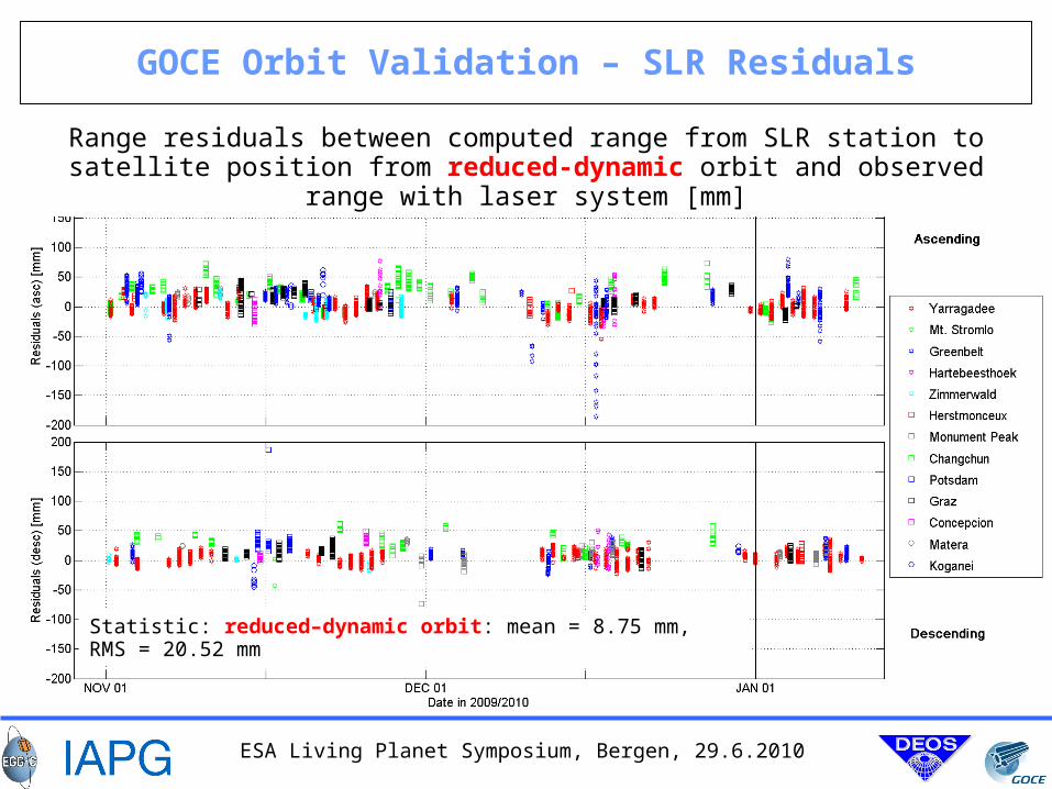
GOCE Orbit Validation – SLR Residuals
Range residuals between computed range from SLR station to satellite position from reduced-dynamic orbit and observed range with laser system [mm]
Statistic: reduced–dynamic orbit: mean = 8.75 mm, RMS = 20.52 mm
ESA Living Planet Symposium, Bergen, 29.6.2010
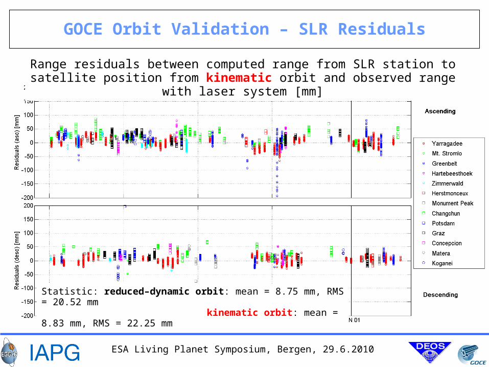
GOCE Orbit Validation – SLR Residuals
Range residuals between computed range from SLR station to satellite position from kinematic orbit and observed range with laser system [mm]
Statistic: reduced–dynamic orbit: mean = 8.75 mm, RMS = 20.52 mm kinematic orbit: mean = 8.83 mm, RMS = 22.25 mm
ESA Living Planet Symposium, Bergen, 29.6.2010
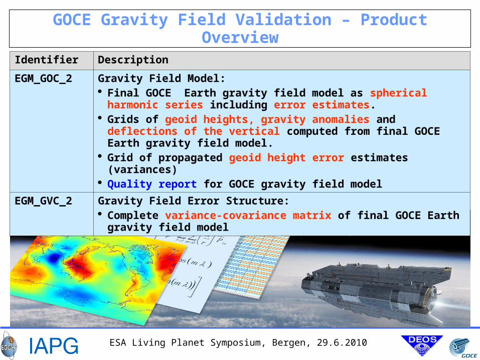
GOCE Gravity Field Validation – Product Overview
Identifier Description
EGM_GOC_2 Gravity Field Model: Final GOCE Earth gravity field model as spherical harmonic series
including error estimates. Grids of geoid heights, gravity anomalies and deflections of the
vertical computed from final GOCE Earth gravity field model. Grid of propagated geoid height error estimates (variances) Quality report for GOCE gravity field model
EGM_GVC_2 Gravity Field Error Structure: Complete variance-covariance matrix of final GOCE Earth gravity field
model
ESA Living Planet Symposium, Bergen, 29.6.2010
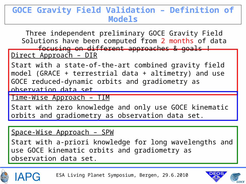
GOCE Gravity Field Validation – Definition of Models
Direct Approach – DIR
Start with a state-of-the-art combined gravity field model (GRACE + terrestrial data + altimetry) and use GOCE reduced-dynamic orbits and gradiometry as observation data set.
Three independent preliminary GOCE Gravity Field Solutions have been computed from 2 months of data focusing on different approaches & goals !
Time-Wise Approach – TIM
Start with zero knowledge and only use GOCE kinematic orbits and gradiometry as observation data set.
Space-Wise Approach – SPW
Start with a-priori knowledge for long wavelengths and use GOCE kinematic orbits and gradiometry as observation data set.
ESA Living Planet Symposium, Bergen, 29.6.2010
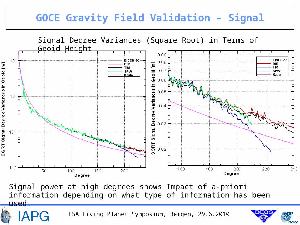
GOCE Gravity Field Validation – Signal
Signal Degree Variances (Square Root) in Terms of Geoid Height
Signal power at high degrees shows Impact of a-priori information depending on what type of information has been used.
ESA Living Planet Symposium, Bergen, 29.6.2010
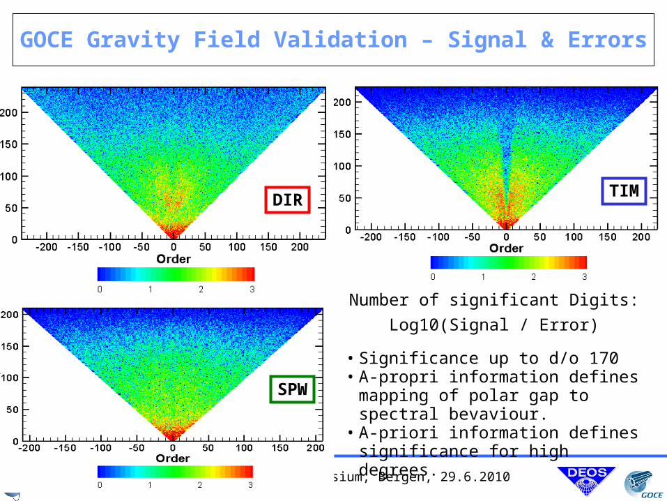
GOCE Gravity Field Validation – Signal & Errors
DIR
SPW
TIM
Number of significant Digits:
Log10(Signal / Error)
• Significance up to d/o 170• A-propri information defines mapping
of polar gap to spectral bevaviour.• A-priori information defines
significance for high degrees.
ESA Living Planet Symposium, Bergen, 29.6.2010
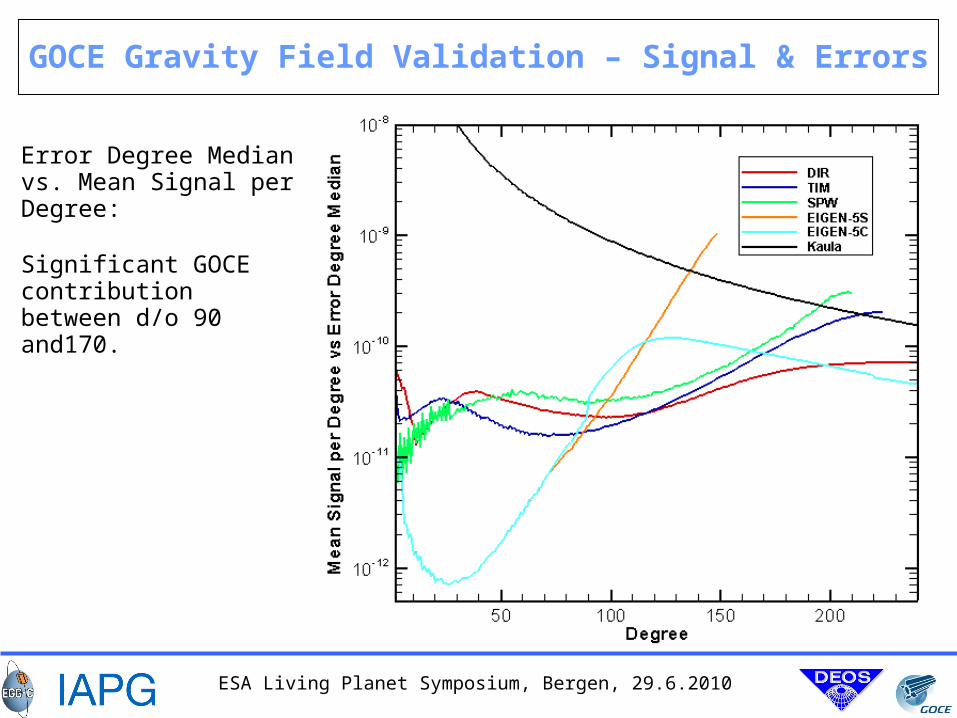
GOCE Gravity Field Validation – Signal & Errors
Significant GOCE contribution between d/o 90 and170.
Error Degree Median vs. Mean Signal per Degree:
ESA Living Planet Symposium, Bergen, 29.6.2010
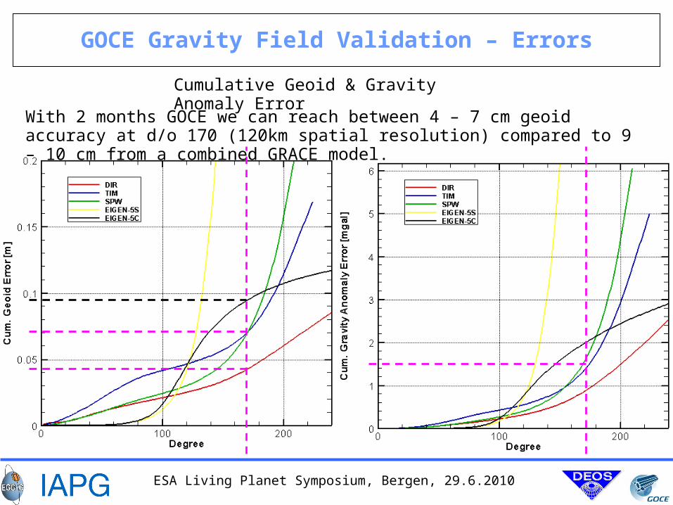
GOCE Gravity Field Validation – Errors
Cumulative Geoid & Gravity Anomaly Error
With 2 months GOCE we can reach between 4 – 7 cm geoid accuracy at d/o 170 (120km spatial resolution) compared to 9 – 10 cm from a combined GRACE model.
ESA Living Planet Symposium, Bergen, 29.6.2010
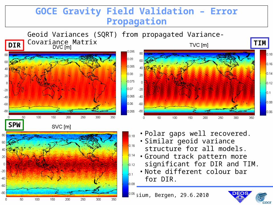
GOCE Gravity Field Validation – Error Propagation
Geoid Variances (SQRT) from propagated Variance-Covariance Matrix
DIR
SPW
TIM
• Polar gaps well recovered.• Similar geoid variance structure for all
models.• Ground track pattern more significant
for DIR and TIM.• Note different colour bar for DIR.
ESA Living Planet Symposium, Bergen, 29.6.2010
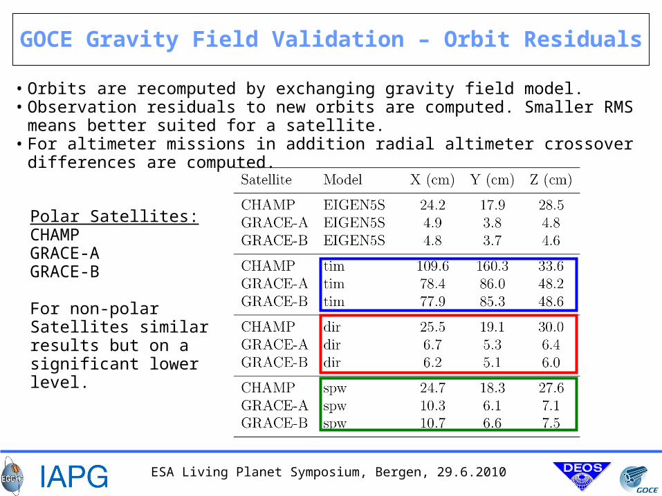
GOCE Gravity Field Validation – Orbit Residuals
• Orbits are recomputed by exchanging gravity field model. • Observation residuals to new orbits are computed. Smaller RMS means better suited
for a satellite.• For altimeter missions in addition radial altimeter crossover differences are
computed.
Polar Satellites:CHAMPGRACE-AGRACE-B
For non-polar Satellites similar results but on a significant lower level.
ESA Living Planet Symposium, Bergen, 29.6.2010
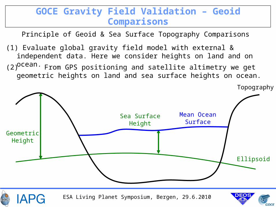
GOCE Gravity Field Validation – Geoid Comparisons
Principle of Geoid & Sea Surface Topography Comparisons
Topography
Ellipsoid
GeometricHeight
(1) Evaluate global gravity field model with external & independent data. Here we consider heights on land and on ocean.
(2) From GPS positioning and satellite altimetry we get geometric heights on land and sea surface heights on ocean.
Mean OceanSurface
Sea SurfaceHeight
ESA Living Planet Symposium, Bergen, 29.6.2010
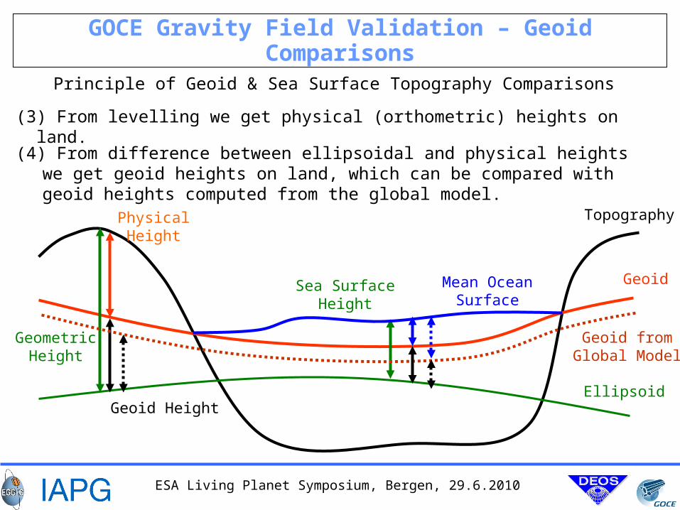
GOCE Gravity Field Validation – Geoid Comparisons
Geoid
GeometricHeight
PhysicalHeight
Sea SurfaceHeight
Geoid Height
Mean OceanSurface
Geoid fromGlobal Model
Topography
Ellipsoid
(3) From levelling we get physical (orthometric) heights on land.
(4) From difference between ellipsoidal and physical heights we get geoid heights on land, which can be compared with geoid heights computed from the global model.
Principle of Geoid & Sea Surface Topography Comparisons
ESA Living Planet Symposium, Bergen, 29.6.2010
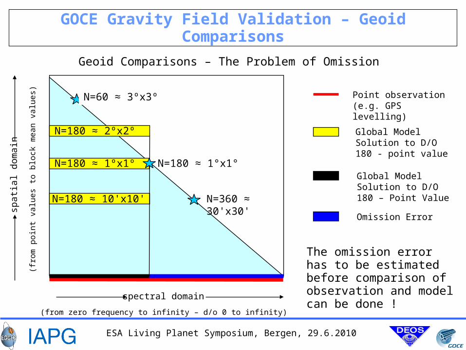
GOCE Gravity Field Validation – Geoid Comparisons
Geoid Comparisons – The Problem of Omission
spectral domain
spat
ial d
omai
n
(from zero frequency to infinity – d/o 0 to infinity)
(fro
m p
oin
t va
lue
s to
blo
ck m
ea
n v
alu
es)
Point observation (e.g. GPS levelling)
N=360 ≈ 30'x30'
N=60 ≈ 3ºx3º
Global Model Solution to D/O 180 - point value
Omission Error
Global Model Solution to D/O 180 – Point Value
N=180 ≈ 2ºx2º
N=180 ≈ 10'x10'
N=180 ≈ 1°x1° N=180 ≈ 1ºx1º
The omission error has to be estimated before comparison of observation and model can be done !
ESA Living Planet Symposium, Bergen, 29.6.2010
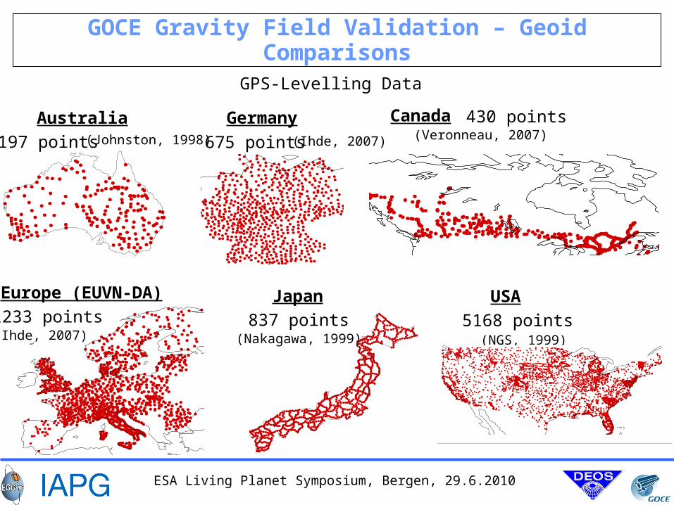
GOCE Gravity Field Validation – Geoid Comparisons
GPS-Levelling Data
Longitude
Longitude
Longitude
Australia
197 points
Germany
675 points
Longitude
Canada 430 points
Longitude
(Veronneau, 2007)(Ihde, 2007)(Johnston, 1998)
Europe (EUVN-DA)
1233 points(Ihde, 2007)
Japan
837 points(Nakagawa, 1999)
USA
5168 points(NGS, 1999)
Longitude
ESA Living Planet Symposium, Bergen, 29.6.2010
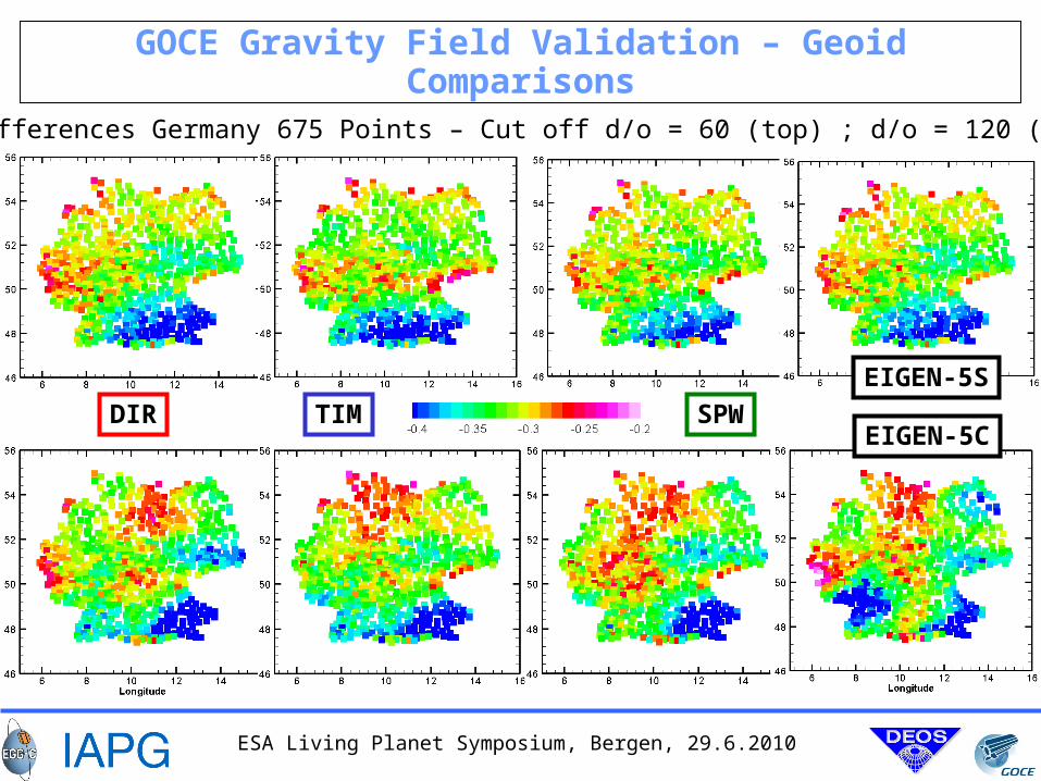
GOCE Gravity Field Validation – Geoid Comparisons
Geoid Differences Germany 675 Points – Cut off d/o = 60 (top) ; d/o = 120 (bottom)
DIR SPWTIM
EIGEN-5S
EIGEN-5C
ESA Living Planet Symposium, Bergen, 29.6.2010
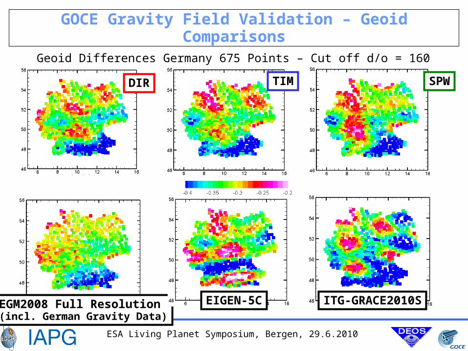
GOCE Gravity Field Validation – Geoid Comparisons
Geoid Differences Germany 675 Points – Cut off d/o = 160
SPWTIMDIR
EGM2008 Full Resolution(incl. German Gravity Data)
EIGEN-5C ITG-GRACE2010S
ESA Living Planet Symposium, Bergen, 29.6.2010
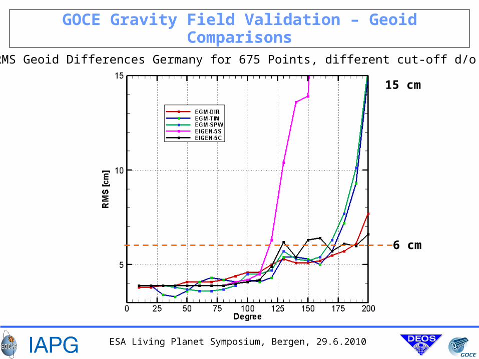
GOCE Gravity Field Validation – Geoid Comparisons
RMS Geoid Differences Germany for 675 Points, different cut-off d/o
6 cm
15 cm
ESA Living Planet Symposium, Bergen, 29.6.2010
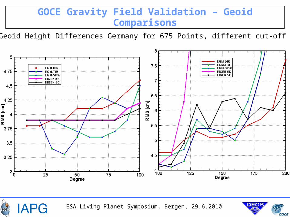
GOCE Gravity Field Validation – Geoid Comparisons
RMS Geoid Height Differences Germany for 675 Points, different cut-off d/o
ESA Living Planet Symposium, Bergen, 29.6.2010
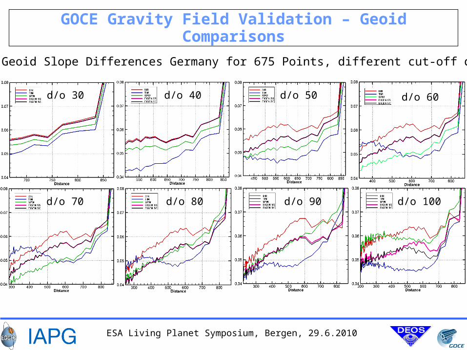
GOCE Gravity Field Validation – Geoid Comparisons
RMS Geoid Slope Differences Germany for 675 Points, different cut-off d/o
d/o 30 d/o 40 d/o 50 d/o 60
d/o 70 d/o 80 d/o 90 d/o 100
ESA Living Planet Symposium, Bergen, 29.6.2010
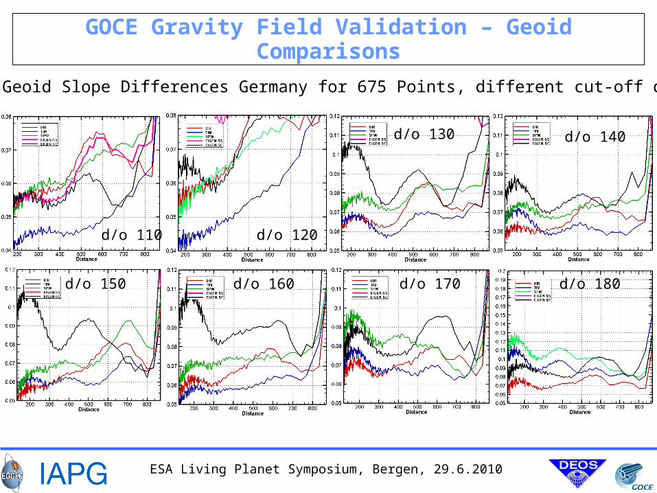
GOCE Gravity Field Validation – Geoid Comparisons
RMS Geoid Slope Differences Germany for 675 Points, different cut-off d/o
d/o 110 d/o 120
d/o 130 d/o 140
d/o 150 d/o 160 d/o 170 d/o 180
ESA Living Planet Symposium, Bergen, 29.6.2010
Conclusions (1)
Precise science orbits show high quality 2-3 cm.
Three preliminary gravity field models based on 2 months of GOCE data are validated by different techniques.
Orbit tests for gravity fields are according to expectations (low frequencies better determined from GRACE type missions).
Tests based on estimated errors show significance of GOCE models up to approx. d/o 170. GOCE improves gravity field between d/o 100 and 170.
Estimated geoid error at a level of 7 cm @ d/o 170 and 12 cm @ d/o 200.
External geoid comparisons confirm internal error estimates: 6 cm @ d/o 170 and 15 cm @ d/o 200.
GOCE fields show remarkable good performance for areas, where high quality comparison data are available.
We can expect significantly improved gravity field knowledge in areas, where sparse or poor terrestrial data is available.
ESA Living Planet Symposium, Bergen, 29.6.2010
Conclusions (2)
How to decide, which model performs best ?
There is no unique answer. In many cases this depends on the application !
Be aware about the characteristics of the preliminary GOCE models in order to choose the right one for your application.
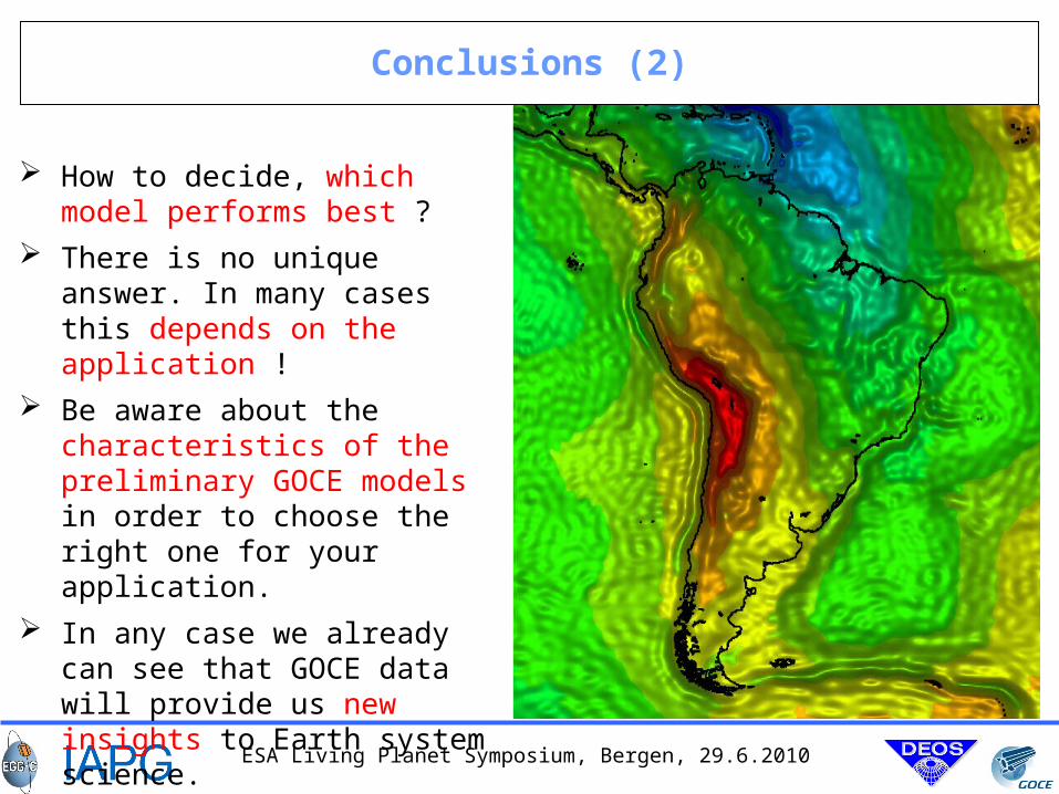
In any case we already can see that GOCE data will provide us new insights to Earth system science.
ESA Living Planet Symposium, Bergen, 29.6.2010
GOCE Award
Therefore, this year the gravity field cup will awarded to all groups involved in GOCE satellite operations and ground data processing.
They do a great job and we expect even more spectacular results based on more GOCE data.