Embed Size (px)
Citation preview
Cruise Report FS Alkor AL-440 06/07 2014
1
FS Alkor AL-440 06/07 2014 (30.06.-12.07.2014)
Cruise Report / Fahrtbericht
Vom Sediment zum Topp-Prädator – Einfluss von
Eigenschaften des Meeresbodens auf Benthos und
benthivore Vögel
Teilprojekt STopP-See
Institut für Geowissenschaften
Sedimentologie, Küsten- und Schelfgeologie
Klaus Schwarzer
Kerstin Wittbrodt
Cruise Report FS Alkor AL-440 06/07 2014
2
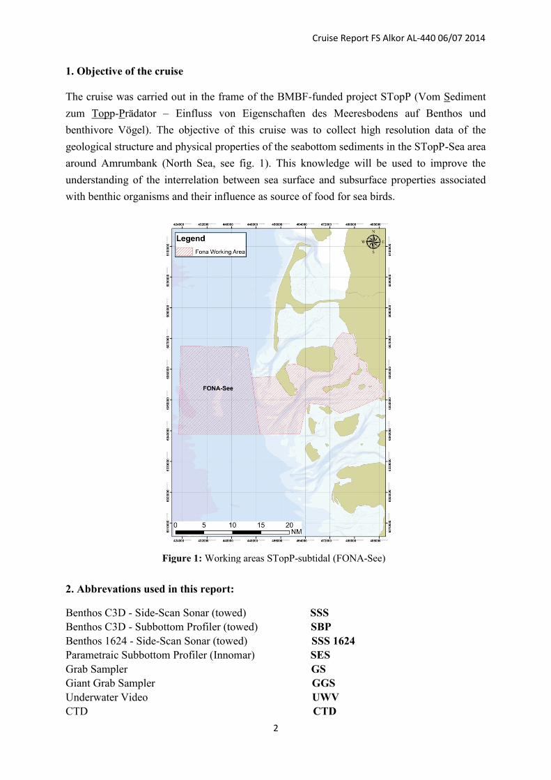
1. Objective of the cruise
The cruise was carried out in the frame of the BMBF-funded project STopP (Vom Sediment
zum Topp-Prädator – Einfluss von Eigenschaften des Meeresbodens auf Benthos und
benthivore Vögel). The objective of this cruise was to collect high resolution data of the
geological structure and physical properties of the seabottom sediments in the STopP-Sea area
around Amrumbank (North Sea, see fig. 1). This knowledge will be used to improve the
understanding of the interrelation between sea surface and subsurface properties associated
with benthic organisms and their influence as source of food for sea birds.
2. Abbrevations used in this report:
Benthos C3D - Side-Scan Sonar (towed) SSS
Benthos C3D - Subbottom Profiler (towed) SBP
Benthos 1624 - Side-Scan Sonar (towed) SSS 1624
Parametraic Subbottom Profiler (Innomar) SES
Grab Sampler GS
Giant Grab Sampler GGS
Underwater Video UWV
CTD CTD
Figure 1: Working areas STopP-subtidal (FONA-See)
Cruise Report FS Alkor AL-440 06/07 2014
3
3. Participants of the cruise:
1. Dr. Klaus Schwarzer (chief scientist), Inst. of Geosciences, Kiel University
2. Kerstin Wittbrodt (PhD student, scientist), Inst. of Geosciences, Kiel University
3. Dr. Peter Richter (scientist), Inst. of Geosciences, Kiel University
4. Gitta Ann von Rönn (PhD student, scientist), Inst. of Geosciences, Kiel University
5. Adrian Metzgen (scientist), Inst. of Geosciences, Kiel University
6. Jakob Mager (scientist), Inst. of Geosciences, Kiel University
7. Eric Steen (technician), Inst. of Geosciences, Kiel University (30.06.-04.07.2014)
8. Sabine Horn (PhD student, scientist), AWI List/Sylt
9. Cosima Merkel (MSc stduent, scientist), AWI List/Sylt
10. Maria Alexandra Ruales Guerra (scientist), Landesbetrieb für Küstenschutz,
Nationalpark und Meeresschutz Schleswig-Holstein
4. CRUISE NARRATIVE
Mo. 30.06.2014
Weather: sunny, partly cloudy, NW 4
07:20 Departing Kiel (SH), transit through Kiel Canal
17:00 Arrival Brunsbüttel
Tu. 01.07.2014
Weather cloudy, NW 4
05:30 Departing Brunsbüttel, heading for working area
12:35 CTD profile
12:45 Deployment of devices (C3D)
We. 02.07.2014
Weather: cloudy, NW 5
08:23 Devices out of water
08:38 CTD profile
10:24 Start of grab sampling
14:45 End of grab sampling
15:56 GGS (1 station)
17:00 Deployment of devices (C3D)
Th. 03.07.2014
Weather: cloudy, SW 6
09:27 Devices out of water
10:05 CTD profile
10:53 Start of grab sampling
15:10 End of grab sampling
15:45 Deployment of devices (C3D)
Cruise Report FS Alkor AL-440 06/07 2014
4
Fr. 04.07.2014
Weather: sunny, S-SW 5
05:00 Devices out of water
06:04 Start of GGS sampling
08:53 End of GGS sampling, transit to Helgoland
12:00 Arrival Helgoland
15:00 Departing Helgoland, heading for working area
18:05 Deployment of devices (C3D)
Sa. 05.07.2014
Weather: cloudy, foggy, SE 4
13:20 Devices out of water
13:25 CTD profile
13:35 Underwater Video Station
14:45 Underwater Video Station
15:07 Underwater Video Station
15:35 Underwater Video Station
15:58 Underwater Video Station
16:30 Deployment of devices (C3D)
Su. 06.07.2014
Weather: cloudy, SE 3
06:10 Devices out of water
06:25 Start of grab sampling
13:10 End of grab sampling
13:25 CTD profile
14:00 Deployment of devices (C3D)
Mo. 07.07.2014
Weather: cloudy - sunny, SW 4
06:15 Devices out of water
06:30 Start of GGS sampling
10:10 End of GGS sampling
10:55 CTD profile
11:05 Deployment of devices (C3D)
Tu. 08.07.2014
Weather cloudy, NE 4
05:20 Devices out of water,
05:25 CTD profile, transit to Helgoland due to increasing bad weather conditions
08:30 Arrival Helgoland
We. 09.07.2014
Weather: cloudy, NE 3
05:30 Departing Helgoland, heading for working area
07:50 CTD profile
08:00 Deployment of devices (C3D), profiling
Cruise Report FS Alkor AL-440 06/07 2014
5
Th. 10.07.2014
Weather: sunny, NE 4
06:10 Devices out of water
06:20 Start of grab sampling
14:35 End of grab sampling
15:44 Underwater Video station
16:10 Underwater Video station
17:05 Deployment of devices (C3D)
Fr. 11.07.2014
Weather: sunny, NE 5
04:40 Devices out of water
05:07 Start of GGS sampling
05:45 End of GGS sampling
05:50 Transit back to Kiel via Kiel Kanal
21:30 Arrival at Kiel GEOMAR Pier
Sa. 12.07.2014
Weather: cloudy-partly sunny
06:00 Unloading of FS Alkor at GEOMAR Pier
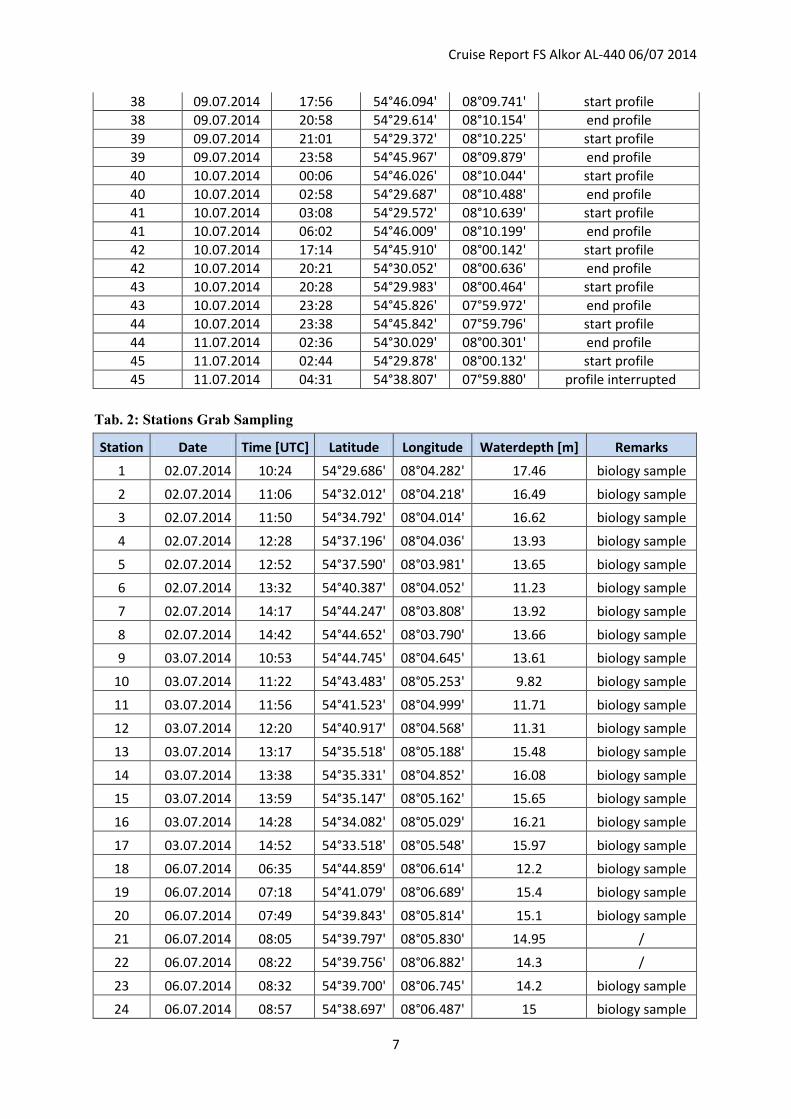
Tab. 1: Hydroacoustic profiling
No Date Time (UTC) Latitude Longitude Remarks
1 01.07.2014 13:19 54°29.529' 08°03.977' start profile
1 01.07.2014 16:21 54°44.846' 08°03.53' end profile
2 01.07.2014 16:29 54°45.065' 08°03.668' start profile
2 01.07.2014 19:33 54°29.547' 08°04.143' end profile
3 01.07.2014 19:41 54°29.576' 08°04.318' start profile
3 01.07.2014 22:47 54°44.856' 08°03.858' end profile
4 01.07.2014 22:59 54°45.040' 08°04.049' start profile
4 02.07.2014 02:03 54°29.601' 08°04.475' end profile
5 02.07.2014 02:15 54°29.444' 08°04.668' start profile
5 02.07.2014 05:17 54°44.941' 08°04.183' end profile
6 02.07.2014 05:23 54°45.040' 08°04.330' start profile
6 02.07.2014 08:23 54°29.568' 08°04.812' end profile
7 02.07.2014 17:09 54°29.872' 08°05.478' start profile
7 02.07.2014 20:23 54°44.997' 08°04.523' end profile
8 02.07.2014 20:30 54°44.960' 08°04.681' start profile
8 02.07.2014 23:39 54°29.636' 08°05.144' end profile
9 02.07.2014 23:51 54°29.543' 08°05.330' start profile
9 03.07.2014 02:57 54°44.913' 08°04.875' end profile
10 03.07.2014 03:05 54°45.032' 08°05.027' start profile
10 03.07.2014 06:08 54°29.569' 08°05.470' end profile
11 03.07.2014 06:15 54°29.585' 08°05.640' start profile
11 03.07.2014 09:23 54°44.997' 08°05.187' end profile
12 03.07.2014 16:02 54°29.531' 08°05.790' start profile
12 03.07.2014 19:04 54°44.987' 08°05.359' end profile
13 03.07.2014 19:11 54°44.978' 08°05.538' start profile
13 03.07.2014 22:16 54°29.662' 08°05.979' end profile
Cruise Report FS Alkor AL-440 06/07 2014
6
14 03.07.2014 22:27 54°29.549' 08°06.141' start profile
14 04.07.2014 01:39 54°44.927' 08°05.698' end profile
15 04.07.2014 01:48 54°45.076' 08°05.901' start profile
15 04.07.2014 04:54 54°29.675' 08°06.306' end profile
16 04.07.2014 18:18 54°29.523' 08°06.455' start profile
16 04.07.2014 21:23 54°44.970' 08°06.036' end profile
17 04.07.2014 21:29 54°44.992' 08°06.206' start profile
17 05.07.2014 00:39 54°29.654' 08°06.647' end profile
18 05.07.2014 00:50 54°29.568' 08°06.831' start profile
18 05.07.2014 03:50 54°44.906' 08°06.378' end profile
19 05.07.2014 03:58 54°45.054' 08°06.541' start profile
19 05.07.2014 07:04 54°29.580' 08°06.981' end profile
20 05.07.2014 07:09 54°29.584' 08°07.148' start profile
20 05.07.2014 10:11 54°44.928' 08°06.711' end profile
21 05.07.2014 10:20 54°45.062' 08°06.854' start profile
21 05.07.2014 13:15 54°29.622' 08°07.323' end profile
22 05.07.2014 16:47 54°46.102' 08°07.015' start profile
22 05.07.2014 20:03 54°29.599' 08°07.470' end profile
23 05.07.2014 20:09 54°29.620' 08°07.611' start profile
23 05.07.2014 23:26 54°46.003' 08°07.184' end profile
24 05.07.2014 23:34 54°45.961' 08°07.427' start profile
24 06.07.2014 02:43 54°29.706' 08°07.809' end profile
25 06.07.2014 02:51 54°29.528' 08°08.006' start profile
25 06.07.2014 06:04 54°45.997' 08°07.503' end profile
26 06.07.2014 16:57 54°29.520' 08°08.155' start profile
26 06.07.2014 20:11 54°46.008' 08°07.682' end profile
27 06.07.2014 20:18 54°45.994' 08°07.847' start profile
27 06.07.2014 23:31 54°29.653' 08°08.317' end profile
28 06.07.2014 23:38 54°29.572' 08°08.467' start profile
28 07.07.2014 02:53 54°45.928' 08°08.021' end profile
29 07.07.2014 03:00 54°46.093' 08°08.160' start profile
29 07.07.2014 06:15 54°29.606' 08°08.645' end profile
30 07.07.2014 11:12 54°45.826' 08°08.371' start profile
30 07.07.2014 14:25 54°29.668' 08°08.812' end profile
31 07.07.2014 14:43 54°29.497' 08°08.951' start profile
31 07.07.2014 18:04 54°46.004' 08°08.546' end profile
32 07.07.2014 18:11 54°45.983' 08°08.730' start profile
32 07.07.2014 21:34 54°29.608' 08°09.157' end profile
33 07.07.2014 21:40 54°29.637' 08°09.319' start profile
33 08.07.2014 01:11 54°45.947' 08°08.880' end profile
34 08.07.2014 01:17 54°46.034' 08°09.012' start profile
34 08.07.2014 04:30 54°29.713' 08°09.489' end profile
35 08.07.2014 04:38 54°29.530' 08°09.661' start profile
35 08.07.2014 04:57 54°31.105' 08°09.614' profile interrupted
35 09.07.2014 08:05 54°30.633' 08°09.603' profile restart
35 09.07.2014 11:07 54°45.970' 08°09.226' end profile
36 09.07.2014 11:14 54°46.014' 08°09.385' start profile
36 09.07.2014 14:26 54°29.642' 08°09.812' end profile
37 09.07.2014 14:36 54°29.530' 08°09.996' start profile
37 09.07.2014 17:50 54°45.939' 08°09.557' end profile
Cruise Report FS Alkor AL-440 06/07 2014
7
38 09.07.2014 17:56 54°46.094' 08°09.741' start profile
38 09.07.2014 20:58 54°29.614' 08°10.154' end profile
39 09.07.2014 21:01 54°29.372' 08°10.225' start profile
39 09.07.2014 23:58 54°45.967' 08°09.879' end profile
40 10.07.2014 00:06 54°46.026' 08°10.044' start profile
40 10.07.2014 02:58 54°29.687' 08°10.488' end profile
41 10.07.2014 03:08 54°29.572' 08°10.639' start profile
41 10.07.2014 06:02 54°46.009' 08°10.199' end profile
42 10.07.2014 17:14 54°45.910' 08°00.142' start profile
42 10.07.2014 20:21 54°30.052' 08°00.636' end profile
43 10.07.2014 20:28 54°29.983' 08°00.464' start profile
43 10.07.2014 23:28 54°45.826' 07°59.972' end profile
44 10.07.2014 23:38 54°45.842' 07°59.796' start profile
44 11.07.2014 02:36 54°30.029' 08°00.301' end profile
45 11.07.2014 02:44 54°29.878' 08°00.132' start profile
45 11.07.2014 04:31 54°38.807' 07°59.880' profile interrupted
Tab. 2: Stations Grab Sampling
Station Date Time [UTC] Latitude Longitude Waterdepth [m] Remarks
1 02.07.2014 10:24 54°29.686' 08°04.282' 17.46 biology sample
2 02.07.2014 11:06 54°32.012' 08°04.218' 16.49 biology sample
3 02.07.2014 11:50 54°34.792' 08°04.014' 16.62 biology sample
4 02.07.2014 12:28 54°37.196' 08°04.036' 13.93 biology sample
5 02.07.2014 12:52 54°37.590' 08°03.981' 13.65 biology sample
6 02.07.2014 13:32 54°40.387' 08°04.052' 11.23 biology sample
7 02.07.2014 14:17 54°44.247' 08°03.808' 13.92 biology sample
8 02.07.2014 14:42 54°44.652' 08°03.790' 13.66 biology sample
9 03.07.2014 10:53 54°44.745' 08°04.645' 13.61 biology sample
10 03.07.2014 11:22 54°43.483' 08°05.253' 9.82 biology sample
11 03.07.2014 11:56 54°41.523' 08°04.999' 11.71 biology sample
12 03.07.2014 12:20 54°40.917' 08°04.568' 11.31 biology sample
13 03.07.2014 13:17 54°35.518' 08°05.188' 15.48 biology sample
14 03.07.2014 13:38 54°35.331' 08°04.852' 16.08 biology sample
15 03.07.2014 13:59 54°35.147' 08°05.162' 15.65 biology sample
16 03.07.2014 14:28 54°34.082' 08°05.029' 16.21 biology sample
17 03.07.2014 14:52 54°33.518' 08°05.548' 15.97 biology sample
18 06.07.2014 06:35 54°44.859' 08°06.614' 12.2 biology sample
19 06.07.2014 07:18 54°41.079' 08°06.689' 15.4 biology sample
20 06.07.2014 07:49 54°39.843' 08°05.814' 15.1 biology sample
21 06.07.2014 08:05 54°39.797' 08°05.830' 14.95 /
22 06.07.2014 08:22 54°39.756' 08°06.882' 14.3 /
23 06.07.2014 08:32 54°39.700' 08°06.745' 14.2 biology sample
24 06.07.2014 08:57 54°38.697' 08°06.487' 15 biology sample
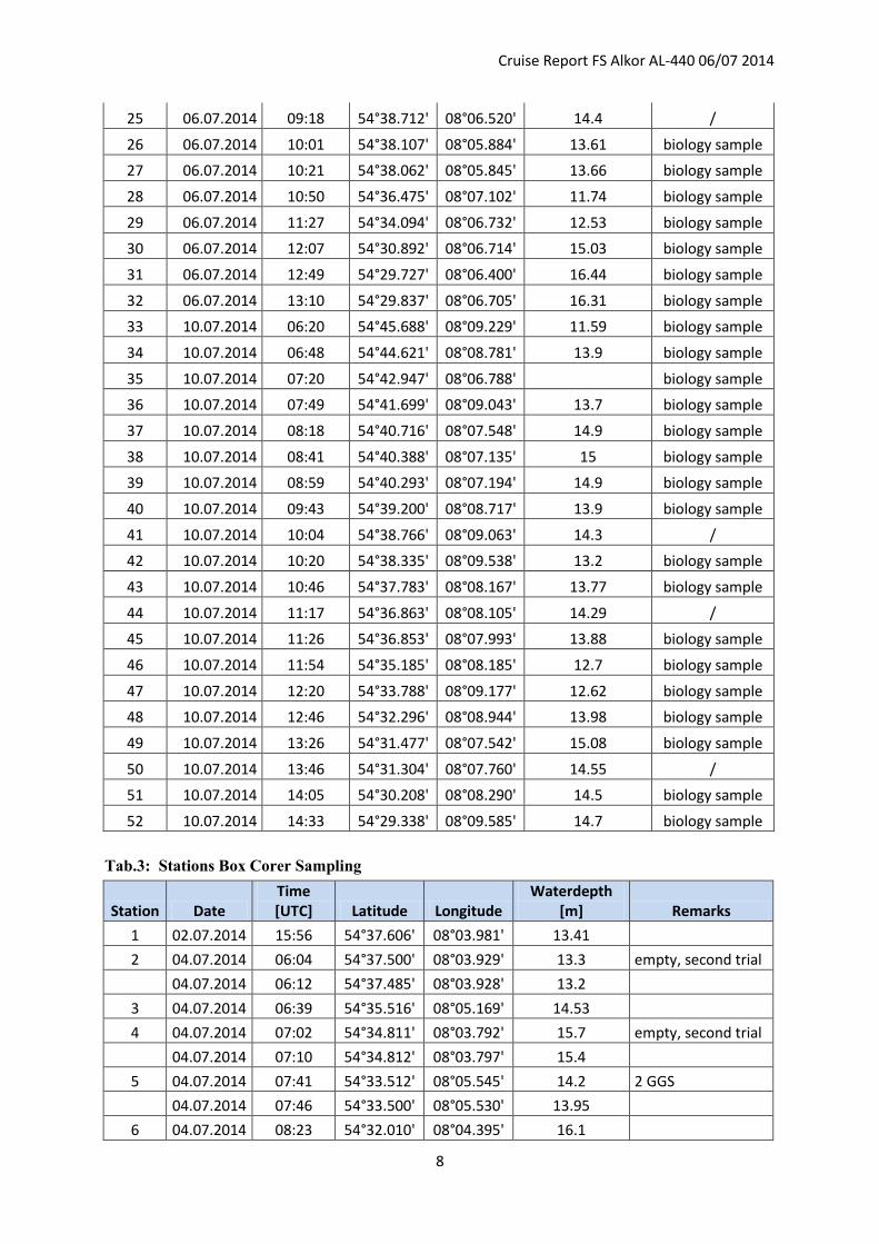
Cruise Report FS Alkor AL-440 06/07 2014
8
25 06.07.2014 09:18 54°38.712' 08°06.520' 14.4 /
26 06.07.2014 10:01 54°38.107' 08°05.884' 13.61 biology sample
27 06.07.2014 10:21 54°38.062' 08°05.845' 13.66 biology sample
28 06.07.2014 10:50 54°36.475' 08°07.102' 11.74 biology sample
29 06.07.2014 11:27 54°34.094' 08°06.732' 12.53 biology sample
30 06.07.2014 12:07 54°30.892' 08°06.714' 15.03 biology sample
31 06.07.2014 12:49 54°29.727' 08°06.400' 16.44 biology sample
32 06.07.2014 13:10 54°29.837' 08°06.705' 16.31 biology sample
33 10.07.2014 06:20 54°45.688' 08°09.229' 11.59 biology sample
34 10.07.2014 06:48 54°44.621' 08°08.781' 13.9 biology sample
35 10.07.2014 07:20 54°42.947' 08°06.788' biology sample
36 10.07.2014 07:49 54°41.699' 08°09.043' 13.7 biology sample
37 10.07.2014 08:18 54°40.716' 08°07.548' 14.9 biology sample
38 10.07.2014 08:41 54°40.388' 08°07.135' 15 biology sample
39 10.07.2014 08:59 54°40.293' 08°07.194' 14.9 biology sample
40 10.07.2014 09:43 54°39.200' 08°08.717' 13.9 biology sample
41 10.07.2014 10:04 54°38.766' 08°09.063' 14.3 /
42 10.07.2014 10:20 54°38.335' 08°09.538' 13.2 biology sample
43 10.07.2014 10:46 54°37.783' 08°08.167' 13.77 biology sample
44 10.07.2014 11:17 54°36.863' 08°08.105' 14.29 /
45 10.07.2014 11:26 54°36.853' 08°07.993' 13.88 biology sample
46 10.07.2014 11:54 54°35.185' 08°08.185' 12.7 biology sample
47 10.07.2014 12:20 54°33.788' 08°09.177' 12.62 biology sample
48 10.07.2014 12:46 54°32.296' 08°08.944' 13.98 biology sample
49 10.07.2014 13:26 54°31.477' 08°07.542' 15.08 biology sample
50 10.07.2014 13:46 54°31.304' 08°07.760' 14.55 /
51 10.07.2014 14:05 54°30.208' 08°08.290' 14.5 biology sample
52 10.07.2014 14:33 54°29.338' 08°09.585' 14.7 biology sample
Tab.3: Stations Box Corer Sampling
Station Date Time [UTC] Latitude Longitude
Waterdepth [m] Remarks
1 02.07.2014 15:56 54°37.606' 08°03.981' 13.41
2 04.07.2014 06:04 54°37.500' 08°03.929' 13.3 empty, second trial
04.07.2014 06:12 54°37.485' 08°03.928' 13.2
3 04.07.2014 06:39 54°35.516' 08°05.169' 14.53
4 04.07.2014 07:02 54°34.811' 08°03.792' 15.7 empty, second trial
04.07.2014 07:10 54°34.812' 08°03.797' 15.4
5 04.07.2014 07:41 54°33.512' 08°05.545' 14.2 2 GGS
04.07.2014 07:46 54°33.500' 08°05.530' 13.95
6 04.07.2014 08:23 54°32.010' 08°04.395' 16.1
Cruise Report FS Alkor AL-440 06/07 2014
9
04.07.2014 08:41 54°32.019' 08°04.368' 15.8 empty, third trial
04.07.2014 08:53 54°32.037' 08°04.359' 15.9
7 07.07.2014 06:32 54°29.839' 08°06.724' 17.72
8 07.07.2014 07:43 54°38.684' 08°06.512' 15.28
9 07.07.2014 08:10 54°39.142' 08°06.718' 14.15
10 07.07.2014 08:23 54°39.239' 08°06.717' 15.54 empty, second trial
07.07.2014 08:31 54°39.232' 08°06.715' 15.04 empty, third trial
07.07.2014 08:43 54°39.231' 08°06.708' 15.05
11 07.07.2014 09:39 54°41.072' 08°06.687' 14.21
12 07.07.2014 10:03 54°41.413' 08°06.477' 14.6
13 11.07.2014 05:06 54°40.389' 08°07.121' 13.14
14 11.07.2014 05:38 54°38.760' 08°09.074' 12.32
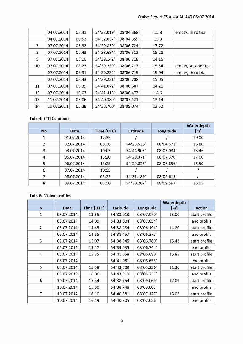
Tab. 4: CTD stations
No Date Time (UTC) Latitude Longitude Waterdepth
[m]
1 01.07.2014 12:35 / / 19.00
2 02.07.2014 08:38 54°29.536` 08°04.571` 16.80
3 03.07.2014 10:05 54°44.905` 08°05.034` 13.46
4 05.07.2014 15:20 54°29.371` 08°07.370` 17.00
5 06.07.2014 13:25 54°29.825` 08°06.656` 16.50
6 07.07.2014 10:55 / / /
7 08.07.2014 05:25 54°31.189` 08°09.615` /
8 09.07.2014 07:50 54°30.207` 08°09.597` 16.05
Tab. 5: Video profiles
o Date Time [UTC] Latitude Longitude Waterdepth
[m] Action
1 05.07.2014 13:55 54°33.013` 08°07.070` 15.00 start profile
05.07.2014 14:09 54°33.004` 08°07,054` end profile
2 05.07.2014 14:45 54°38.484` 08°06.194` 14.80 start profile
05.07.2014 14:55 54°38.457` 08°06.377` end profile
3 05.07.2014 15:07 54°38.945` 08°06.780` 15.43 start profile
05.07.2014 15:17 54°39.035` 08°06.744` end profile
4 05.07.2014 15:35 54°41,058` 08°06.680` 15.85 start profile
05.07.2014 54°41.081` 08°06.655` end profile
5 05.07.2014 15:58 54°43,509` 08°05.236` 11.30 start profile
05.07.2014 16:06 54°43,519` 08°05.231` end profile
6 10.07.2014 15:44 54°38.754` 08°09.069` 12.09 start profile
10.07.2014 15:50 54°38.748` 08°09.005` end profile
7 10.07.2014 16:10 54°40.381` 08°07.127` 13.02 start profile
10.07.2014 16:19 54°40.305` 08°07.056` end profile
Cruise Report FS Alkor AL-440 06/07 2014
10
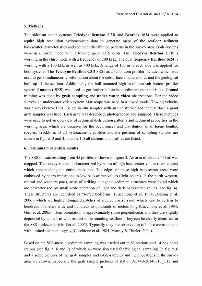
5. Methods
The sidescan sonar systems Teledyne Benthos C3D and Benthos 1624 were applied to
aquire high resolution hydroacoustic data to generate maps of the seafloor sediment
backscatter characteristics and sediment distribution patterns in the survey area. Both systems
were in a towed mode with a towing speed of 5 knots. The Teledyne Benthos C3D is
working in the chirp mode with a frequency of 200 kHz. The dual frequency Benthos 1624 is
working with a 100 kHz as well as 400 kHz. A range of 100 m to each side was applied for
both systems. The Teledyne Benthos C3D SSS has a subbottom profiler included which was
used to get simultaneously information about the subsurface characteristics and the geological
built-up of the seafloor. Additionally the hull mounted high resolution sub bottom profiler
system (Innomar-SES) was used to get further subsurface sediment characteristics. Ground
truthing was done by grab sampling and under water video observations. For the video
surveys an underwater video system Mariscope was used in a towed mode. Towing velocity
was always below 1m/s. To get in situ samples with an undisturbed sediment surface a giant
grab sampler was used. Each grab was described, photographed and sampled. These methods
were used to get an overview of sediment distribution patterns and sediment properties in the
working area, which are decisive for the occurrences and distribution of different benthic
species. Tracklines of all hydroacoustic profiles and the position of sampling stations are
shown in figures 2 and 4. In table 1-5 all stations and profiles are listed.
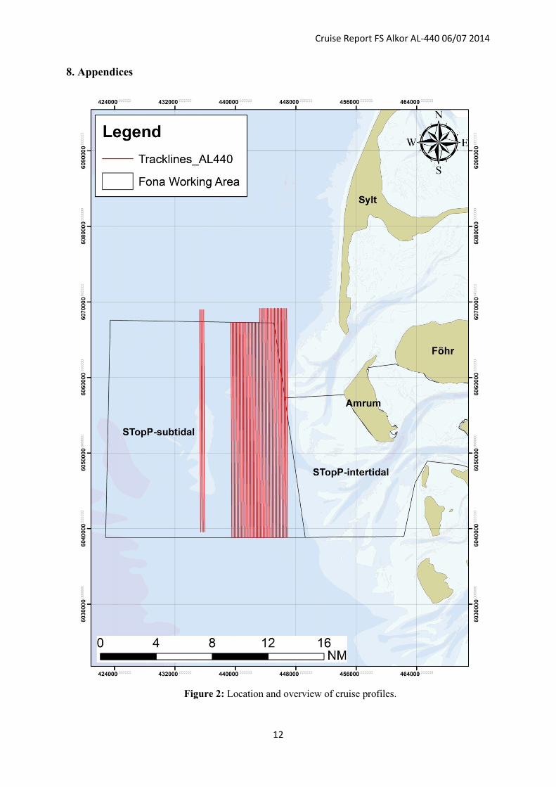
6. Preliminary scientific results
The SSS mosaic resulting from 45 profiles is shown in figure 3. An area of about 240 km2 was
mapped. The surveyed area is characterized by zones of high backscatter values (dark colors)
which appear along the entire tracklines. The edges of these high backscatter areas were
embossed by sharp transitions to low backscatter values (light colors). In the north-western,
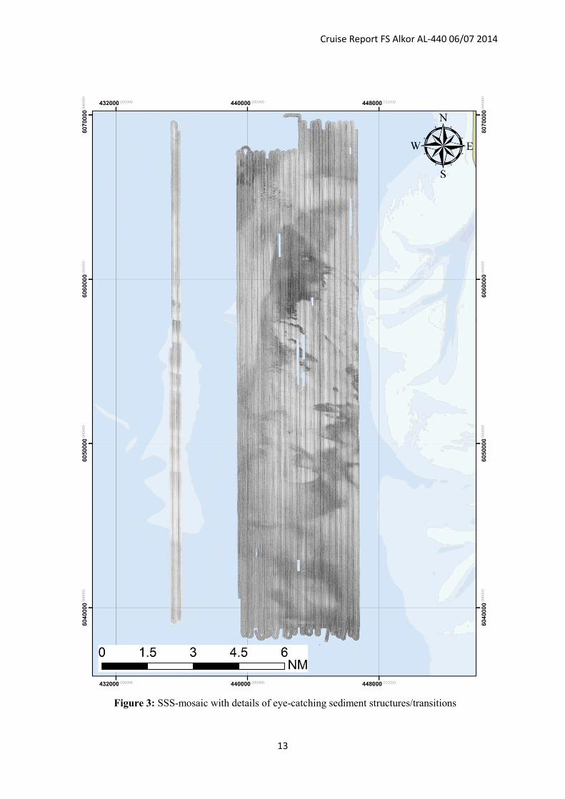
central and southern parts, areas of striking elongated sediment structures were found which
are characterized by small scale alteration of light and dark backscatter values (see fig. 4).
These structures are identified as “sorted bedforms” (Cacchione et al. 1984, Diesing et al.
2006), which are highly elongated patches of rippled coarse sand, which tend to be tens to
hundreds of meters wide and hundreds to thousands of meters long (Cacchione et al. 1984;
Goff et al. 2005). Their orientation is approximately shore perpendicular and they are slightly
depressed by up to 1 m with respect to surrounding seafloor. They can be clearly identified in
the SSS-backscatter (Goff et al. 2005). Typically they are observed in offshore environments
with limited sediment supply (Cacchione et al. 1984, Murray & Thieler 2004).
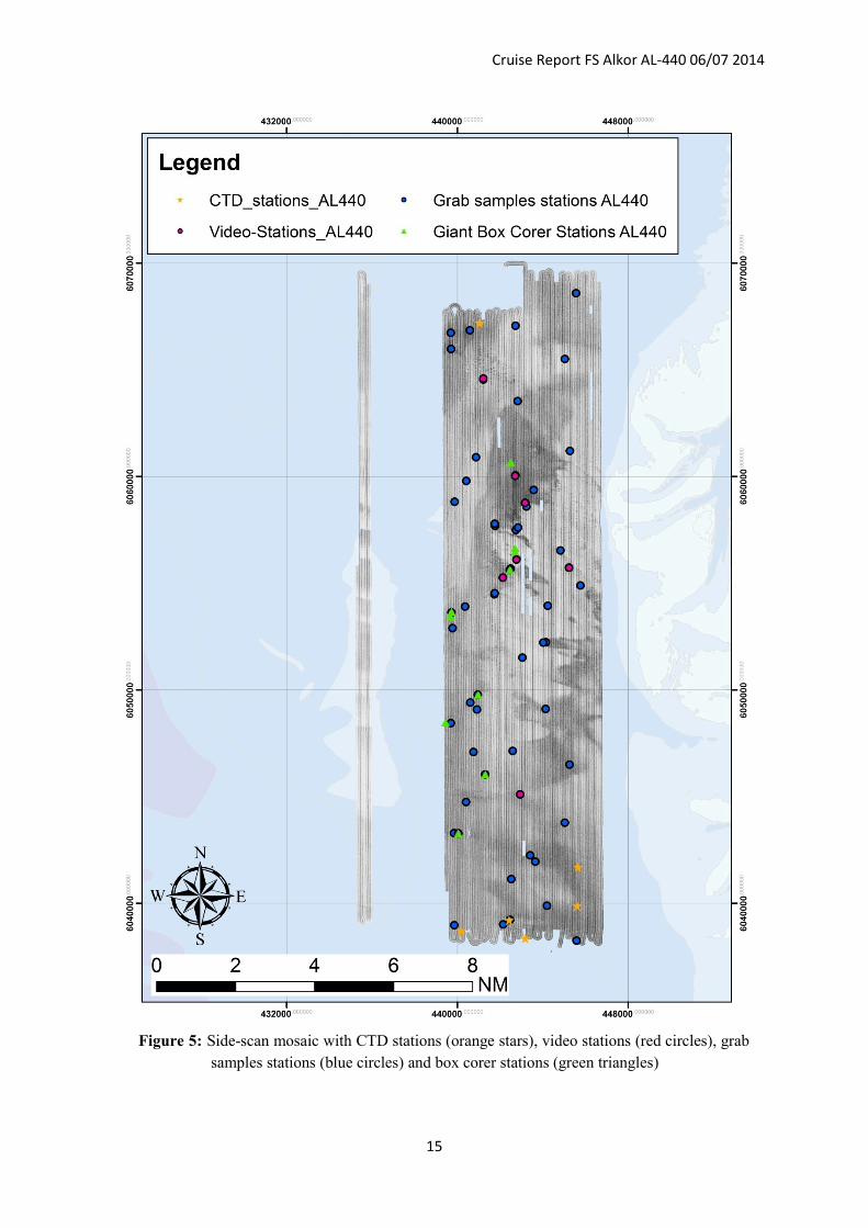
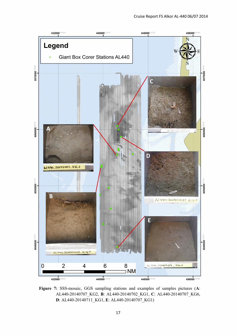
Based on the SSS-mosaic sediment sampling was carried out at 52 stations and 14 box corer
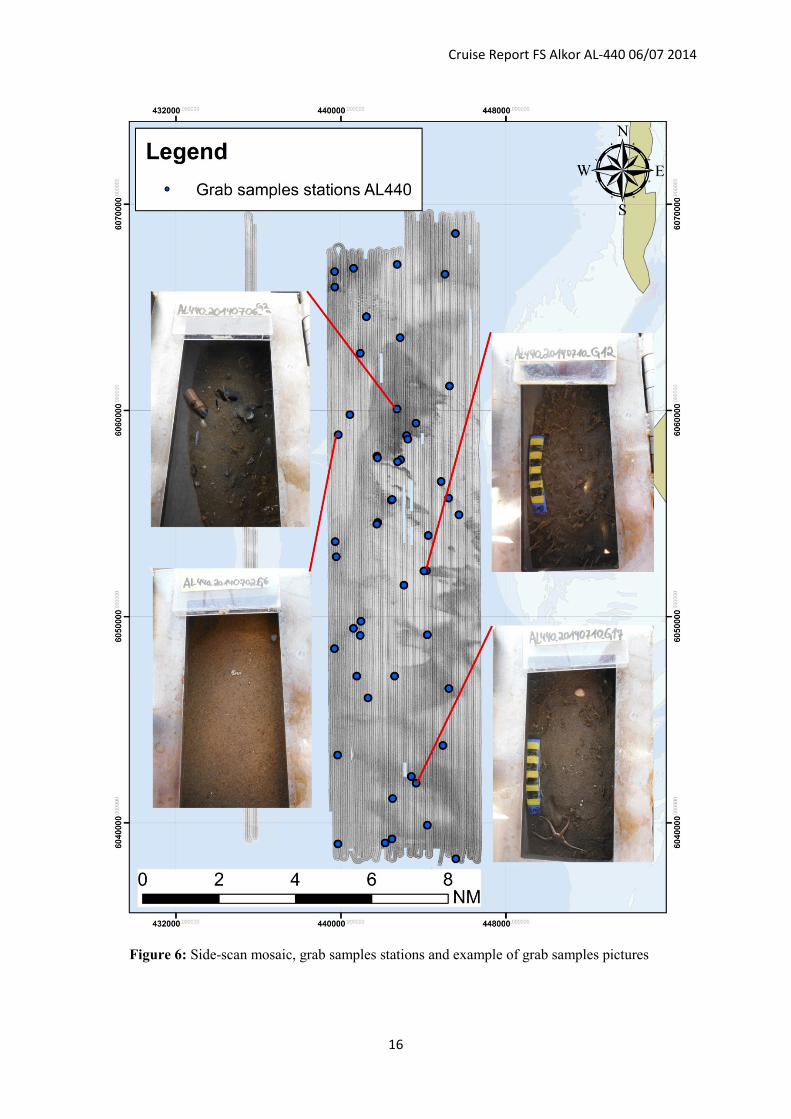
staions (see fig. 5, 6 and 7) of which 46 were also used for biological sampling. In figure 6
and 7 some pictures of the grab samples and GGS-samples and their locations in the survey
area are shown. Especially the grab sample pictures of station AL440-20140710_G12 and
Cruise Report FS Alkor AL-440 06/07 2014
11
AL440-20140710_G17 as well as the GGS pictures AL440-20140707_KG6 and AL440-
20140711_KG1 (see fig. 8) present the occurrence of the benthic organism Lanice conchilega
which obviously was responsible for the eye-catching high backscatter values (Degraer et al.
2008, Heinrich et al. 2014, in preparation) in large parts of the working area. The populations
of Lanice conchilega also were found in the underwater video profiles showing dense
population in some areas. In these video profiles, sediment structures which were found in the
sidescan sonar waterfall window, like ripple structures, were also present. As there seems to
be no essential difference in the grain size distribution of stations with Lanice conchilega
cover and without, the differences in backscatter strength within the working area are
obviously induced by the Lanice conchilega populations (Degraer et al. 2008).
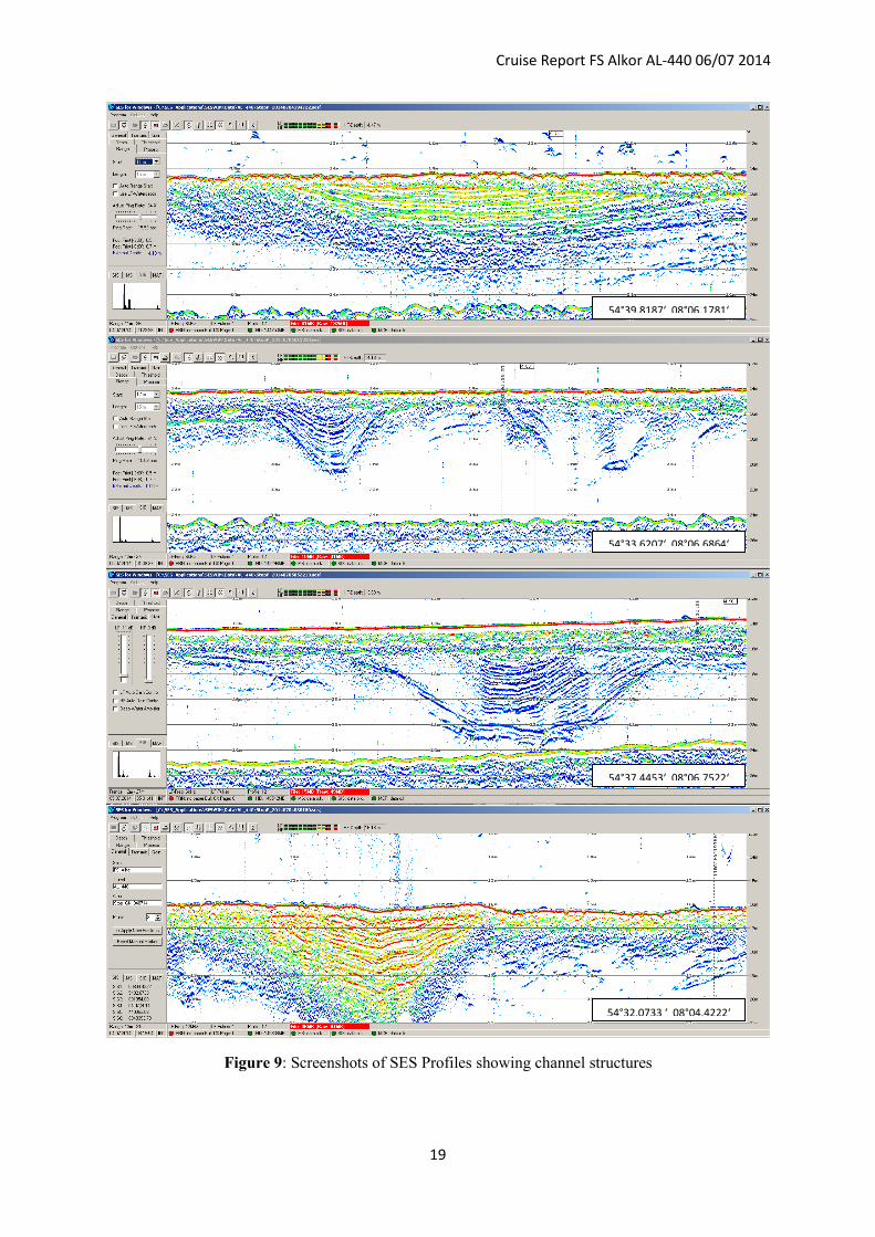
Besides SSS-measurements, grab sampling and GGS-sampling subbottom profiler data were
collected to get information of the geological built-up and thickness of layers in the working
area. Within these profiles several channel structures were identified (see figure 9)
characterized by an E-W/SE-NW orientation.
7. References
Cacchione, D.A., Drake, D.E., Grant, W.D. & Tate, W.B. (1984): Rippled scour depressions
on the inner continental shelf off central California. Journal of Sedimentary Petrology 54,
1280–1291.
Degraer, S., Moerkerke, G., Rabaut, M., Van Hoey, G., Du Four, I., Vincx, M., Henriet, J.P.
& Van Lancker, V. (2008): Very-high resolution side-scan sonar mapping of biogenic reefs of
the tube-worm Lanice conchilega. Remote Sensing of Environment 112, 3323-3328.
Diesing, M., Kubicki, A., Winter, C., Schwarzer, K., (2006): Decadel stability of sorted
bedforms, German Bight, southeastern North Sea. – Continental Shelf Research, 26, 902 –
916.
Goff, J.A., Mayer, L.A., Traykovski, P., Buynevich, I., Wilkens, R., Raymond, R., Glang, G.,
Evans, R.L., Olson, H. & Jenkins, C. (2005): Detailed investigation of sorted bedforms, or
‘‘rippled scour depressions’’, within the Martha’s Vineyard Coastal Observatory,
Massachusetts. Continental Shelf Research 25 (4), 461–484.
Heinrich, C., Feldens, P., Schwarzer, K., (2013): Impact of the tubeworm Lanice conchilega
on the interpretation of side scan sonar backscatter data – in prepartion
Murray, A.B. & Thieler, E.R. (2004): A new hypothesis for the formation of large-scale
inner-shelf sediment sorting and ‘rippled scour depressions’. Continental Shelf Research 24,
295–315.
Cruise Report FS Alkor AL-440 06/07 2014
12
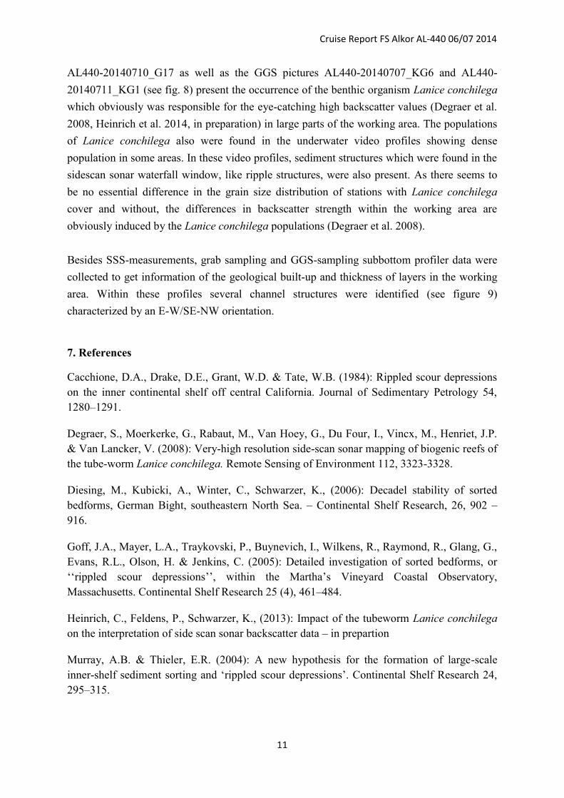
8. Appendices
Figure 2: Location and overview of cruise profiles.
Cruise Report FS Alkor AL-440 06/07 2014
13
Figure 3: SSS-mosaic with details of eye-catching sediment structures/transitions
Cruise Report FS Alkor AL-440 06/07 2014
14
Figure 4: SSS-mosaic with details of eye-catching sediment transitions identified as sorted
bedforms
Cruise Report FS Alkor AL-440 06/07 2014
15
Figure 5: Side-scan mosaic with CTD stations (orange stars), video stations (red circles), grab
samples stations (blue circles) and box corer stations (green triangles)
Cruise Report FS Alkor AL-440 06/07 2014
16
Figure 6: Side-scan mosaic, grab samples stations and example of grab samples pictures
Cruise Report FS Alkor AL-440 06/07 2014
17
Figure 7: SSS-mosaic, GGS sampling stations and examples of samples pictures (A:
AL440-20140707_KG2, B: AL440-20140702_KG1, C: AL440-20140707_KG6,
D: AL440-20140711_KG1, E: AL440-20140707_KG1)
E
D
C
B
A
Cruise Report FS Alkor AL-440 06/07 2014
18
Station 5
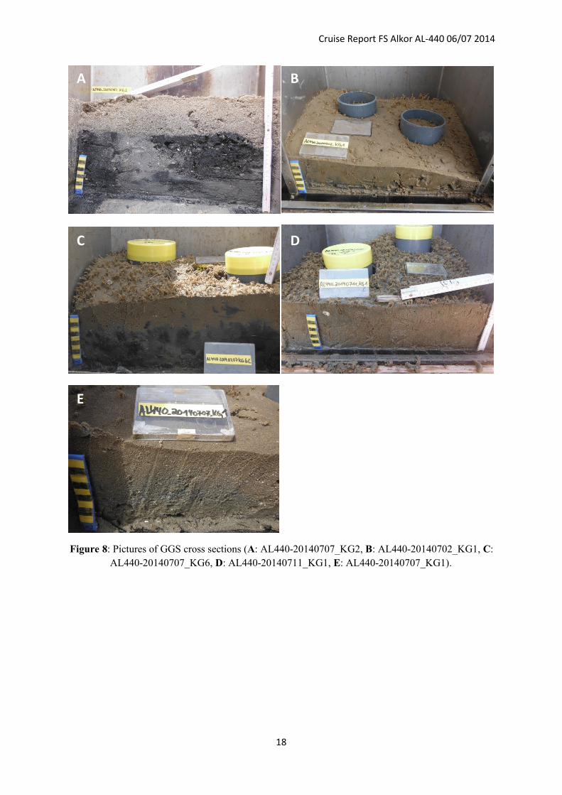
Figure 8: Pictures of GGS cross sections (A: AL440-20140707_KG2, B: AL440-20140702_KG1, C:
AL440-20140707_KG6, D: AL440-20140711_KG1, E: AL440-20140707_KG1).
A B
C D
E
Cruise Report FS Alkor AL-440 06/07 2014
19
Figure 9: Screenshots of SES Profiles showing channel structures
54°39.8187‘ 08°06.1781‘
54°33.6207‘ 08°06.6864‘
54°37.4453‘ 08°06.7522‘
54°32.0733 ‘ 08°04.4222‘