Embed Size (px)
Citation preview
WWW.VISITVALSUGANA.ITViale V. Emanuele, 3 - 38056 Levico Terme (TN) Tel. +39 0461 727700 - Fax +39 0461 727799 [email protected]
AziendA per il Turismo VAlsugAnA
© Copyright foto: Apt Valsugana - Story Traveler - E-Mancini, ADAC TRENTINO CLASSIC 2012, Apt Altopiano di Pinè e Valle di Cembra, Apt Val di Fiemme, Apt Fassa - Angeli - Montibeller, Foto Archivio Alta Marca, Apt Val di Non - Ruffini, Dolomiti Turismo, Vicenza è
2,00 €
VIAGGIARE NELLA NATURA IN VALSUGANA E LAGORAI
TRAVELLING IN NATURE IN VALSUGANA AND IN THE LAGORAI CHAIN Guidare
nel verdeDriving into the nature Fahrten ins GrüneItinerari per automobili e moto Itineraries for cars and motorbikes Routen für Autos und Motorräder
2013
WWW.VISITVALSUGANA.IT
La Valsugana, grazie alla sua posizione geografica ed ai suoi paesaggi variegati, si presenta come punto di partenza ideale per appassionanti tour in moto e in automobile, alla scoperta degli angoli più belli e suggestivi del Trentino Alto Adige e delle regioni vicine. Partendo dai fondovalle, caratterizzati dai frut-teti colorati e dagli imponenti castelli medioevali, passando per caratteristici paesini per poi affrontare avventurosi tornanti e valicare i passi, si scopriranno paesaggi di rara bellezza, circondati dalle splendide vette della catena del Lagorai e delle Dolomiti. La durata dei tours segnalata è indicativa, poiché essi si snodano per lo più su strade di montagna, pertanto è bene tener presente che vanno percorsi rispettando i limiti, la segnaletica ed i divieti. In questo depliant sono presentate 12 proposte d’itinerari ad anello, adatti sia agli amanti della guida rilassante che agli appassionati della curva, che dopo aver attraversato alcune delle più belle località del Trentino e dei territori vicini ritornano in Valsugana, per conoscerne la cultura, la storia ed il folklore, per soggiornare nelle accoglienti strutture ricettive ed assaggiare i piatti tipici della tradizione locale e, perché no, rilassarsi con le cure termali o con una passeggiata nella natura.Si declina ogni responsabilità circa la manutenzione dei percorsi che, per cause meteorologiche o di forza maggiore, potrebbero subire delle interruzioni.
IT
The Valsugana valley, thanks to its geographical position and its varied landscape, is an excellent starting point for exhilarating car and motorbike tours, on which you can discover the most beautiful and picturesque corners of Trentino Alto Adige and its neighbouring regions. Starting from the foot of the valley, characterized by colourful fruit orchards and majestic medi-eval castles, you will go through green fields and highlands spotted with traditional villages, then face thrilling hairpin bends that will bring you to mountain passes, all of which leads to the discovery of landscapes of rare beauty, surrounded by the splendid peaks of the Dolomites and the Lagorai mountain chains. The time needed indicated is indicative as the tours un-wind along mountain roads, so please mind speed limits and road signs must be respected. Twelve ring routes are suggested in this brochure, suitable for drivers who like a relaxing drive and for those who have a passion for bends. After having crossed some of the most beautiful places in Trentino and in surrounding areas, you return to the Valsugana to experience its culture, history and traditions, to be a guest in the different types of accommodation it offers, to taste local traditional dishes and, why not, to relax whilst having a spa treatment or a walk in nature.We decline all responsibility as to the maintenance of the routes, which, for weather reasons or reasons beyond our control, may be interrupted.
GB
DURCH DIE NATUR DES VALSUGANA&LAGORAI REISEN
Das Valsugana eignet sich aufgrund seiner geografischen Lage und den vielfältigen Landschaftsbildern hervorragend als Ausgangspunkt für Auto- oder Motorradausflüge, bei denen man die suggestivsten Ecken der Region Trentino- Südtirol und der Nachbarregionen kennen lernen kann. Es geht im Tal, mit seinen bunten Obstplantagen und den imposanten mittelalterlichen Schlössern, los und weiter vorbei an kleinen charakteristischen Orten, über gewagte Kehren und Bergpässe, um Landschaften von besonderer Schönheit zu entdecken, die von den Gipfeln der Lagorai-Bergkette und den Dolomiten umgeben sind. Die Zeitangaben der Touren sind Richtwerte, da die Strecken vorwiegend über Bergstraßen führen. Aus diesem Grund ist es auch noch wichtiger Tempolimits und Hinweis- bzw. Verbotsschilder zu beachten. In dies-er Broschüre gibt es 12 ringförmig verlaufende Tourenvorschläge, die sich für alle Typen von Fahrern eignen, die die eine entspannte Runde drehen möcht-en oder für diejenigen, die kurvenreiche Strecken bevorzugen. Auf jeden Fall fährt man dabei durch einige der schönsten Orte des Trentino und der angren-zenden Regionen, um dann immer wieder ins Valsugana zurückzukehren. Man lernt die Kultur, die Geschichte und die traditionellen Gepflogenheiten kennen, übernachtet in gemütlichen Unterkünften und probiert die typischen wohlschmeckenden Gerichte der Region und warum nicht – erholt sich in einer der Therme oder bei einem Spaziergang in der Natur.Für die Instandhaltung der Verkehrswege der Touren wird keine Haftung übernommen, die aufgrund von widrigen Witterungsbedingungen oder Wirkung höherer Gewalten unterbrochen sein können.
D
IN VALSUGANA E LAGORAI… DA NON PERDERE!Per una vacanza completa la Valsugana ed il Lagorai offrono infinite possibilità: il relax dello stare distesi al sole in riva al lago,
le passeggiate in mezzo al verde delle montagne, le attività proposte, il gusto di assaggiare i prodotti tipici nei, il piacere di farsi coccolare nei centri termali, la gioia di partecipare alle manifestazioni locali divertendosi assieme agli abitanti del luogo… Oltre a tutto questo non può mancare la possibilità di conoscere la cultura dei vari paesi, visitando i molti siti che premettono di avvicinarsi ancora di più alla storia e le tradizioni locali: il Castello di Pergine e Castel Ivano ad Ivano Fracena, le numerose chiesette storiche ornate da splendidi affreschi, i forti delle Guerre Mondiali, l’arte moderna della mostra a cielo aperto Arte Sella, nonché i numerosi musei ed esposizioni dislocati sul territorio … tutto porta a conoscere meglio gli usi e costumi della Valsugana e del Lagorai, una terra da scoprire. Da non perdere sono anche gli eventi: le feste gastronomiche e le manifestazioni sportive e culturali restano il modo migliore per conoscere al meglio la rinomata ospitalità e la gioia di vivere di questa zona.
IT
NOT TO BE MISSED IN VALSUGANA AND LAGORAITo complete your holiday, Valsugana and Lagorai offer an infinite number of opportunities: relaxation in the sun on the lake-
shores, walks surrounded by the greenery of the mountains, the activities suggested for the summer, tasting typical dishes, the pleasure of being pampered in one of the health spas, the joy of taking part in one of the local festivals enjoying oneself with the local people…Besides all this, one cannot overlook the possibility of learning about local village culture, of visiting the numerous sites that allow you learn even more about the history and local traditions: Pergine Castle and Ivano Castle, the numerous historic churches decorated with beautiful frescoes, the Forts of the Great World Wars, the open air modern art of Arte Sella, as well as the many museums and exhibitions scattered across the territory, …everything contributes to acquiring knowledge about customs and traditions of the Valsugana valley and Lagorai, a land to be discovered. Not to be missed are also the organized events: the gastronomic festivals, the sports and cultural events that are still the best way to experience the famous hospitality and joie de vivre of this area.
GB
IM VALSUGANA&LAGORAI …WAS MAN NICHT VERPASSEN SOLLTE!Das Valsugana&Lagorai bietet unzählige Möglichkeiten für einen kompletten Urlaub: Erholung bei einem entspannenden
Sonnenbad am Ufer der Seen oder bei einem Spaziergang im Grün der Berge, Genuss beim Probieren typischer Produkte, Wohlbefinden bei einem Besuch in der Therme, Spaß zusammen mit den Einheimischen bei einer der vielen Veranstaltun-gen… Darüber hinaus lernt man bei einem Besuch der vielen Sehenswürdigkeiten die Kultur, Geschichte und die lokalen Traditionen kennen: z.B. auf den Schlössern Castel Pergine oder Castel Ivano in Ivano Fracena, den zahlreichen historischen Kirchen mit ihren wunderschönen Freskenmalereien und Ornamenten, den Werken aus dem Ersten Weltkrieg, bei moderner Kunst unter freiem Himmel bei der Ausstellung Arte Sella, sowie den vielen Museen und Ausstellungen im gesamten Territo-rium… auf diese Weise erfährt man viel Interessantes über das Valsugana&Lagorai, ein Gebiet, das es zu erkunden gilt. Und man sollte bei den vielen Veranstaltungen: den gastronomischen Festen, den Sportevents und den kulturellen Highlights vorbeischauen. Das ist sicher der beste Weg, die bekannte Gastlichkeit und die Lebensfreude zu erleben.
D
Partenza StartAbfahrt
Tempo di percorrenza Travel timeFahrtzeit
Lunghezza del percorso Path’s lenghtTourenlänge
* la durata è da intendersi per l’intero itinerario effettuato senza pause.** la durata ed il chilometraggio delle varianti sono da intendersi come giro completo dal punto di partenza al punto d’arrivo passando per le stesse varianti.
* the duration is meant for the entire journey performed without pause.** the duration and mileage of the variants are to be understood as complete turn from the starting point to the ending point via the same variants.
SIMBOLOGIA / GUIDE TO SYMBOLS / ZEICHENERkLäRUNG ODER SYMBOLIk
ValsuganaTRENTINO
TRENTO
TRENTO
LEGENDA / LEGEND / LEGENDEAutostrada a casello Motorway / Autobahn
Superstrada / Highway / Schnellstraße
Strade importanti Important roads / Wichtigen Strassen
Strade secondarie Side Roads / Nebenstraßen
1 ALTA VALSUGANA E LAGHI 2 TESINO E BASSA VALSUGANA
5 VAL DI FASSA - DOLOMITI 12 VAL DI NON - MERANO - STRADA DEL VINO
8 ASIAGO E ALTIPIANO DEI 7 COMUNI 10 VALLI GIUDICARIE - LAGO DI GARDA
7 VALDOBBIADENE - VALSUGANA VENETA 11 VAL DI SOLE - DOLOMITI DI BRENTA
3 VAL DI CEMBRA - BOLZANO - VAL DEI MOCHENI 6 FELTRINO
4 VAL DI FIEMME - LAGORAI 9 LAGO DI GARDA - ROVERETO - VALLARSA
Lago / Lake / See
Fiume / River / Fluss
Torrenti / Torrents / Bäche
Passo / Pass / Pass
Quota / Height / Höhe
Montagne / Mountains / Berge
Confine stato State Line / Staatsgrenze
Città / City / Stadt
Paesi / Towns / Ortschaften
Centri minori Little centres / kleinere Ortschaften
Confine regione Region Border / Grenze der Region
12
36
711
512
49
10 8
Si declina ogni responsabilità circa la manutenzione dei percorsi che, per cause meteorologiche o di forza maggiore, potrebbero subire delle interruzioni.We decline all responsibility as to the maintenance of the routes, which, for weather reasons or reasons beyond our control, may be interrupted.
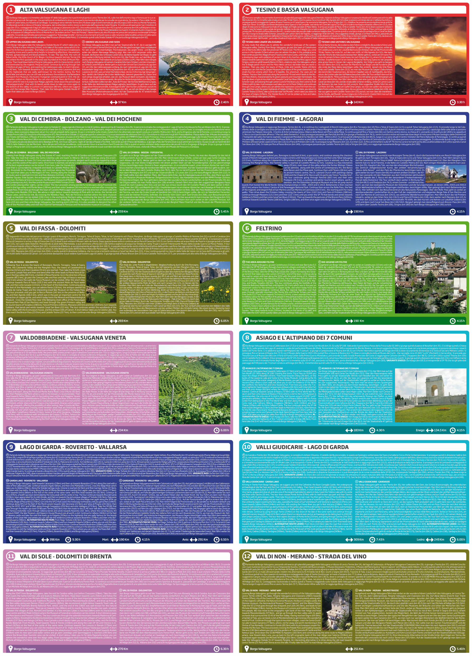
ALTA VALSUGANA E LAGHI
Borgo Valsugana
Da Borgo Valsugana ci si immette sulla Statale 47 della Valsugana che in pochi minuti porta a Levico Terme (km 14), sulle rive dell’omonimo lago e famosa per le sue ac-que termali arsenicali-ferruginose, che permettono di combattere lo stress e sono particolarmente indicate per la cura alle vie respiratorie. Da vedere: il Parco delle Terme, i ruderi di Castel Selva, la chiesetta di San Biagio. Si prosegue verso Vetriolo Terme (km 24) dove sorge il centro termale più alto d’Europa (1500 m slm) sul Monte Panarotta. Si ridiscende quindi a ridosso di Pergine Valsugana, dal caratteristico centro storico e dominata dall’imponente Castel Pergine. Si continua attraversando San Cristoforo Al Lago (km 37) e, costeggiando il lago di Caldonazzo, si giunge a Calceranica (km 42). Una svolta porta a Bosentino (km 45) e quindi a Lavarone (km 64) sull’altipiano triste-mente famoso per le battaglie della Prima Guerra Mondiale, di cui sono ancora visibili le testimonianze: il Forte Museo Belvedere Gschwent, il Comando Austro Ungarico dei Virti, la Stazione di Collegamento Ottica di Monte Rust. Da vedere anche l’”Avez del Prinzep”, l’abete bianco più alto d’Europa nei pressi del complesso residenziale di Malga Laghetto. Si scende quindi dalla panoramica e suggestiva “Kaiserjägerstraße”, che tra curve e tornanti arriva di nuovo a valle nei pressi della località Lochere di Caldonazzo (km 80), dove si consiglia una visita al Garage Bike Museum (Museo della Moto). Ci si immette quindi sulla Strada Statale 47 che porta a Borgo Valsugana (km 92).
IT
UPPER VALSUGANA AND LAkESFrom Borgo Valsugana take the Valsugana Statale Route 47 which takes you to Levico Terme in a few minutes (14 km), to its lake of the same name which is fa-mous for its ferrous spa water, that helps cure states of asthenia or breakdowns caused by stress and is particularly helpful in breathing affections, rheumatism, thyroid, gynaecological and blood problems. To see: The Spa Park, the ruins of Selva Castle, the little church of St. Biagio. Continue towards Vetriolo Terme (24 km) where the first spa bath in the area was founded at the foot of Mount Pan-arotta. Then head down behind Pergine Valsugana, with its characteristic centre and dominated by the majestic Pergine Castle. Continue by driving through San Cristoforo al Lago (37 km), and coasting the Caldonazzo Lake, to reach Calceran-ica (42 km). Turn towards Bosentino (45 km) and then onto Lavarone (64 km) on the highlands that are sadly well-known for the battles during the First World War and where you can still see and witness the evidence: the Belvedere Gschwent Fort Museum, the Austro-Hungarian command point in Virti, the ob-servation station on Mount Rust. You can also visit the “Avez del Prinzep”, the tallest white fir tree in Europe near Malga Laghetto. Drive down the picturesque “KaiserjagerstraSe”, that with its bends winds down to take you once again to the bottom of the valley to Lochere in Caldonazzo (80 km), where we suggest you visit the Garage Bike Museum. Then take the Valsugana Statale Route 47 again that takes you back to Borgo (92km).
OBERES VALSUGANA UND SEENVon Borgo Valsugana aus fährt man auf der Staatsstraße Nr. 47, die in wenigen Mi-nuten nach Levico Terme führt (km 14), am Ufer des gleichnamigen Sees und bekannt für sein arsen- und eisenhaltiges Thermalwasser, das gegen Stress und Beschw-erden der oberen Atemwege Wirkung zeigt. Was man nicht verpassen sollte: den Kurpark, die Ruinen des Schlosses Castel Selva, die kleine Kapelle San Biagio. Es geht dann weiter in Richtung Vetriolo Terme (km 24). Hier findet man, auf dem Berg Pan-arotta, das höchste Thermalzentrum Europas (1500m ü.d.M.). Man fährt dann bergab nach Pergine Valsugana mit seinem charakteristischem Ortskern und dem imposant-en Schloss Castel Pergine. Weiter geht es durch den Ortsteil San Cristoforo al Lago (km 37), am Ufer des Caldonazzosees entlang, bis nach Calceranica al Lago (km 42). Am Kreisverkehr biegt man in Richtung Bosentino (km 45) ab und erreicht demzufolge Lavarone (km 64), was auf einer Hochebene liegt, die durch ihre traurige Vergangen-heit, nämlich die Kämpfe des Ersten Weltkrieges, bekannt geworden ist. Davon sind noch einige Zeugnisse erhalten, wie z.B.: das Museum Werk Gschwent, das österre-ichisch-ungarische Oberkommando, die optische Verbindungsstation zum Berg Mon-te Rust. Außerdem sollte man den „Avez de Prinzep“ die höchste Weißtanne Europas, in der Nähe des Wohnkomplexes Malga Laghetto, besichtigen. Es geht dann auf der suggestiven Panoramastraße „Kaiserjägerstraße“ über Kurven und Kehren zurück ins Tal in die Lokalität Lochere von Caldonazzo (km 80), wo sich ein Besuch des Garage Bike Museums (Motorradmuseum) lohnt. Auf der Staatsstraße Nr. 47 erreicht man dann Borgo Valsugana, den Ausgangspunkt (km 92).
GB D
2.40 h97 Km
VAL DI FASSA - DOLOMITI
Borgo Valsugana
Seguendo il tracciato del percorso 4 lungo i paesi di Roncegno, Ronchi, Torcegno, Telve di Sopra, Telve, la Val Calamento ed il Passo Manghen, da Borgo Valsugana si giunge a Castello-Molina di Fiemme (km 52) e quindi a Cavalese (km 55). Ci si immette poi sulla SS 620 che, valicando il paesaggistico Passo di Lavazé, porta a Ponte Nova di Sopra in Val d’Ega (km 80,5), frazione di Nova Ponente. Si svolta quindi in direzione Nova Levante (km 85,5), si sorpassano i Lago e Passo di Carezza e si arriva a Vigo di Fassa (km 102,5) dove si può visitare il Museo Ladin de Fascia. Dopo questa breve sosta si continua verso Pera di Fassa (km 105,5) con l’antico mulino ad acqua Molin de Pezol e si giunge quindi a Canazei (km 115), nel cuore delle Dolomiti. Procedendo ai piedi della Marmolada, si può ammirare a Penia (km 118) l’antica segheria ad acqua Sia Strèda de Ciamp Trujan e quindi l’interessante Museo della Grande Guerra sul Passo Fedaia. Il tour continua arrivando a Rocca Pietore (km 141), in provincia di Belluno, e successivamente ad Agordo (km 166,5), in passato importante centro d’attività estrattiva della pirite cuprifora che oggi ospita il Museo Mineralogico e Paleontologico. Si prosegue valicando il Passo Cereda nei pressi di Villa Welsperg (sede dell’Ente Parco Naturale Paneveggio - Pale di San Martino) e lungo la verde Valle di Primiero attraversando le località turistiche di Tonadico (km 198), Fiera di Primiero (km 199), Mezzano (km 203) ed Imer (km 204); si svolta quindi in direzione Gobbera, che tra curve e tornanti conduce a Canal San Bovo (km 215). Il tour continua quindi tra i boschi della Valle del Vanoi con la Casa dell’Ecomuseo e gli anti-chi mulini della frazione di Cainari. Con una breve deviazione si può vedere il particolare Lago di Calaita. Si giunge quindi al Passo Brocon (km 23 0) ed a Castello Tesino (km 23 7), per procedere poi alla volta di Borgo Valsugana (km 269).
6.05 h269 Km
VAL DI CEMBRA - BOLZANO - VAL DEI MOCHENI
Borgo Valsugana
Partendo da Borgo Valsugana si sale lungo la Statale 47, raggiungendo il bivio per la Val di Cembra, appena prima di Civezzano (km 29). Si percorre la strada che costeggiando il Lago di Santa Colomba porta fino ad Albiano (km 38,5). Si prose-gue quindi sulla strada provinciale che porta a Faver (km 51,5) che passa vicino alle piramidi di Segonzano, eleganti pinnacoli di terra sormontati da un grosso masso, e l’omonimo castello. Giunti a Faver, si consiglia una piccola deviazione verso Cembra, dove si possono degustare alcuni tra i vini più pregiati della regione. Di qui ci si immette sulla strada statale 612 che attorniata dai vigneti conduce a Castello-Molina (km 78,5), porta d’ingresso alla Val di Fiemme, e si continua lungo la Strada Provinciale 232 che porta a Montagna (km 97). Percorrendo la Statale 12 si giunge quindi a Laives (km 111) e successivamente a Bolzano (km 122 ). Da visitare in città sono tra gli altri Piazza Walther, Piazza delle Erbe, il Museo Archeologico con l’Uomo del Similaun, il Museo di Scienze Naturali, il Museion (museo di Arte Moderna e Contemporanea), il Museo Mercantile ed il MMM Firmian (Castel Firmiano). Il tour prosegue tra splendidi paesaggi sulla Strada Provinciale 241 della Val D’Ega fino a Ponte Nova (km 138) e successivamente, valicando il suggestivo Passo di Lavazè, si arriva a Cavalese (km 161). Di qui si riattraversa il paese di Castello-Molina e si prosegue in direzione Sover (km 181) e quindi verso Bedollo (km 191). Si consiglia una piccola deviazione verso Baselga di Pinè, con il suo santuario, i laghi di Serraia e Piazze e l’Ice Rink. Valicando quindi il Passo del Redebus, si giunge a Palù del Fersina dove si può ammirare la miniera–museo Gruab va Hardimbl (km 199,5) nella fiabesca Val dei Mocheni, terra dei piccoli frutti per eccellenza, continuando il tour si arriva fino a Sant’Orsola (km 206) e quindi al centro visitatori della cooperativa dei piccoli frutti a Zivignago di Pergine. Di qui si giunge in breve tempo a Pergine (km 215) e quindi al punto di partenza Borgo Valsugana (km 240). Eventualmente si può scendere dal lato della località Fierozzo, visitando il Maso Filzerhof ed il Museo del Paracarro a Canezza.
5.45 h259 Km
VALDOBBIADENE - VALSUGANA VENETA
Borgo Valsugana
Iniziando da Borgo Valsugana si sorpassa Castelnuovo (km 3,5) ed in prossimità della località Barricata (km 5,5) si svolta sulla SP 78 che attraversando i caratteristici paesini giunge a Pieve Tesino (km 17,5) ed a Castello Tesino (km 21). Si prosegue quindi sull’Altipiano di Celado (km 26) e, passando a fianco a Forte Leone in località Cima Campo (fortificazione della Prima Guerra Mondiale), si arriva sul Col Perer (km 41). Si continua fino ad Arsié (km 51), Fonzaso (km 60) e Oltra frazione di Lamon (km 68) percorrendo la Sr 50 del Passo Rolle. Nei pressi dello stretto ponte si gira in direzione Sovramonte (km 73) e si raggiungono, lungo la Strada Provinciale del Monte Avena, Croce d’Aune (km 92,5) e quindi Pedavena (km 92,5) dove si consiglia di visitare la Birreria Artigianale. Si raggiunge poi la città di Feltre (km 96) dove si può ammirare l’affascinante Centro Storico con la Piazza Maggiore e si prosegue per la città di Valdobbiadene (km 120) lungo le rive del Fiume Piave. In zona è possibile se-guire la Strada del Prosecco (strada panoramica lungo la quale si possono visitare monumenti e siti di forte rilevanza storico-artistica) e l’Anello del Prosecco (itinerario naturalistico che si snoda lungo i vigneti, con possibilità di degustazioni). Nei pressi di Crocetta del Montello (km 129) si viaggia quindi verso ovest attraversando alcune località venete ricchissime dal punto di vista storico e culturale e note per essere state fronte di guerra nei conflitti mondiali tra cui: Castelfranco Veneto (km 151) città dell’artista Giorgione, Cittadella (km 164,5) con le sue mura medievali e Bassano del Grappa (km179,5) famosa per il Ponte degli Alpini, il pittore Jacopo da Ponte e la lavorazione della ceramica. Si ritorna quindi in Trentino percorrendo la SS 47 fino a Borgo Valsugana (km 234).
6.00 h234 Km
TESINO E BASSA VALSUGANA
Borgo Valsugana
Percorso semplice che permette di ammirare gli splendidi paesaggi della Valsugana Orientale. Iniziando da Borgo Valsugana si sorpassa la cittadina di Castelnuovo ed in località Barricata (km 8) ci si immette sulla strada provinciale 78 del Tesino. Il primo paese che si incontra è Villa Agnedo (km 9,5) dove si possono ammirare dei cervi nell’area faunistica; si prosegue quindi costeggiando il paese di Ivano Fracena con il Castel Ivano che sovrasta la Valsugana, fino a Strigno (km 11), cittadina che presenta ancora testimonianze antiche nelle sue chiese. Si consiglia una breve deviazione verso Spera e la Val Campelle, oasi verde nel cuore del Lagorai. Da Strigno si risale la montagna arrivando a Bieno (km 15,5), dove degni di nota sono la chiesa parrocchiale di San Biagio ed il tiglio secolare di Maso Weiss. Si arriva poi ai paesi di Pieve, Cinte e Castello Tesino (km 20,5) dove si possono visitare il Museo-Casa De Gasperi (casa natale del grande statista), le piccole chiesette tra cui spicca quella di Sant’Ippolito, l’Arboreto, le Grotte e la Val Malene. Il tour continua sulla strada provinciale 79 che porta al Passo Brocon (km 41), caratterizzato dai pascoli e dalle numerose malghe dove. Si scende quindi su una tipica strada di montagna fino a Canal San Bovo (km 56) e lungo la strada dello Schener, passando per Lamon (terra del fagiolo), si raggiunge Arsiè (km 84). Una suggestiva strada, giunge a Col Perer (km 94) e, passando per Cima Campo dove si può ammirare dall’esterno l’imponente Forte Leone, continua fino al verde altipiano di Celado (km 109). Di qui si ritorna a Castello Tesino (km 115), da dove una particolare strada “del Murello”, porta alla cittadina di Grigno (km 125). La Statale 47 della Valsugana si ricollega quindi a Borgo Valsugana (km 143).
3.30 h143 Km
FELTRINO
Borgo Valsugana
Partendo da Borgo Valsugana si sorpassa Castelnuovo (km 3,5) ed in prossimità della località Barricata (km 5,5) si svolta sulla SP 78 che attraversando diversi paesini giunge a Pieve Tesino (km 17,5) e quindi a Castello Tesino (km 21). Appena superato il paese in direzione Passo Brocon ci si immette sulla SP della Roa che attraversando lo spettacolare canyon formato dal torrente Senaiga porta a Lamon (km 37,5), terra del fagiolo. Si prosegue lungo la SP di Lamon e quindi sulla SS 50 sormontata dal piccolo santuario della Chiesetta di San Silvestro, approdando dapprima ad Imer (km 54), poi a Mezzano (km 55), a Fiera di Primiero (km 59), con la Chiesa Arcipretale della Madonna dell’Assunta, il Palazzo del Dazio e la chiesetta roma-nica di San Martino, ed infine a Tonadico (km 60). Il tour continua ai piedi del Parco Nazionale delle Dolomiti Bellunesi fino ad Agordo (km 91,5). Di qui si procede lungo la Strada Regionale Agordina che, passando tra splendide montagne come Monte Alto e Monte Schiara, conduce a Sedico (km 117); si svolta quindi per arrivare a Trichiana (km 124), città insignita della medaglia al valore militare per i sacrifici della sua popolazione e per la battaglia partigiana durante la Seconda Guerra Mondiale. Immettendosi sulla SP635 e valicando il Passo di S. Boldo si giunge a Novena (km 141) ed a Cison di Valmarino (km 144). Si prosegue alla volta della città di Valdobbiadene (km160,5), nella zona rinomata per il tipico Prosecco, e si arriva a Feltre (km 184), città storica dove si consiglia una visita al Santuario di SS. Vittore e Corona ad Anzù ed al centro storico della città con la pittoresca Piazza Maggiore. Si svolta quindi in direzione Arsiè (km 199), situata sulle sponde dell’omonimo lago, e ci si immette sulla SS47 che riporta velocemente a Borgo Valsugana (km 233).
4.15 h190 Km
VAL DI FIEMME - LAGORAI
Borgo Valsugana 4.15 h190 Km
ASIAGO E L’ALTIPIANO DEI 7 COMUNI
Borgo Valsugana
Da Borgo Valsugana si arriva a Caldonazzo (km 17,5) e si svolta per Centa San Nicolò (km 23 ,5) sulla SP 108. Valicando il panoramico Passo della Fricca sulla SS 349 si giunge quindi al paese di Nosellari (km 33 ). Ci si dirige quindi a Chiesa (km 36,5), sulle sponde del Lago di Lavarone e sede del particolare Museo del Miele. Percorrendo la SS 349 e sorpassando Monte Rovere, si arriva al suggestivo Passo Vezzena dove con una breve passeggiata si possono ammirare i reperti bellici del Forte Verle. Ci si addentra quindi nell’Altipiano dei 7 comuni : si giunge a Camporovere di Roana (km 66,5) con il Forte Interrotto e quindi ad Asiago (km 69,5) dove sicuramente d’interesse è la visita al Sacrario Militare Leiten. Si prosegue fino a Canove di Roana (km 72,5) con il Museo della Guerra 1915-18 e quindi fino a Cesuna di Roana (km 77) dove si consiglia la visita al Museo dei Cuchi, che raccoglie circa 10.000 “cuchi” (fischietti in terracotta). Si procede per Tresché Conca di Roana (km 80) con il Forte di Punta Corbin della Prima Guerra Mondiale e, percorrendo la bella Strada Provinciale del Costo si raggiungono Caltrano (km 96), Chiuppano (km 98,5), Carrè (km 100) e quindi Thiene (km 105) con il Castello Porto Colleoni. Il tour prosegue sulla SP VIII che attraversa Breganze (km 113), ed arriva a Marostica (km 122 ), famosa per la rinomata partita a scacchi viventi. Si giunge quindi a Bassano del Grappa (km 131) con l’affascinante centro storico ed il rinomato Ponte degli Alpini e ci si immette sulla SS 47 che, passando sul fondovalle, porta direttamente a Borgo Valsugana (km 183). VARIANTE ENEGO: Da Asiago (km 69,5) si intraprende la SP 76 che tra gli splendidi paesaggi dell’Altipiano dei 7 Comuni conduce ad Enego (km 96,5). Immettendosi quindi sulla SS 47 si ritorna a Borgo Valsugana (km 134,5).
IT
VAL DI CEMBRA - BOLZANO - VAL DEI MOCHENILeaving from Borgo Valsugana along the Statale 47 road, reaching the Val di Cembra exit just before Civezzano (29 km). Take the road that coasts the Santa Colomba Lake and leads to Albiano (38.5 km). Continue along the provin-cial road that leads to Faver (51.5 km) and skirts the Segonzano pyramids, elegant earth pinnacles topped by a large stone, and the castle of the same name. Once Faver is reached, we advise a slight detour towards Cembra where some of the best regional wines can be tasted. From here, take the Statale 612 road that is surrounded by vineyards and leads to Castello Molina (78.5 km), threshold to the Fiemme valley, and continue along the Provincial 232 road that takes you to Montagna (97 km). Driving along the Statale 12 route Lavis is reached (111 km) and then Bolzano (122 km). In the city, Walther Square, Erbe Square, the archaeological Museum with the Simi-laun man, the Natural Science museum, the Museion (museum of Modern and Contemporary Art), the Mercantile Museum and MMM Firmian (Firmi-ano Castle) among other sights, can be visited. The tour proceeds among wonderful landscapes along Provincial 241 road in the Ega valley until Ponte Nova (138 km) and then onto Cavalese (161 km) which is reached after crossing the Lavazè Pass. From here go through the town of Castello Molina again and continue in the direction of Sover (181 km) and then onto Bedollo (191 km). We advise a slight detour towards Baselga di Pinè with its shrine, the Serraia and Piazze Lakes, and the ice rink. By crossing the Redebus Pass, Palù del Fersina is reached where the mine-museum Gruab va Hardimbl can be visited (199.5 km) in the enchanting Mocheni valley, continuing the tour till Sant’Orsola (206 km) and then onto the forest fruit establishment in Zivignago di Pergine. Pergine is only a short distance from here (215 km) and then onto Borgo Valsugana, the starting point (240 km). It is also possible to descend the other side of the Mocheni valley and visit the Filzerhof farmstead in Fierozzo and the kerbstone museum in Canezza.
GB VAL DI CEMBRA - BOZEN - FERSENTALLos geht es in Borgo Valsugana auf der Staatsstraße Nr. 47 in Richtung Trento, bis man den Abzweig für das Val di Cembra erreicht, kurz vor Civezzano (km 29). Man nimmt dann diese Straße, vorbei am See Lago Santo Colomba, bis nach Albiano (km 38,5). Weiter geht es dann auf der Provinzstraße bis nach Faver (km 51,5), ganz in der Nähe von Segonzano, wo man kleine Erdpyramiden mit einem großen Stein auf der Pyramidenspitze und das gleichnamige Schloss besichtigen kann. Einmal in Faver angekommen, ist es empfehlenswert, einen kleinen Abstecher nach Cem-bra zu machen und einige der kostbarsten Weine der Region verkosten. Auf der Staatsstraße 612 geht es dann, vor-bei an Weinreben, bis nach Castello-Molina (km 78,5), dem Tor ins Val di Fiemme. Auf der Provinzstraße 232 erreicht man dann Montagna (km 97) und auf der Staatsstraße Nr. 12 Laives (km 111) und darauffolgend Bozen (km 122). In der Stadt sollte man den Walther-Platz, die Piazza delle Erbe, das Archäologiemuseum mit Ötzi, dem Mann aus dem Eis, das Museion (Museum Moderner Zeitgenössischer Kunst), das Handelsmuseum und das MMM Firmian (Schloss Firmian) besichtigen. Die Tour geht dann zwischen den wunderschönen Landschaften, an der Provinzstraße 241 des Val D’Egna weiter, bis man Ponte Nova (km 138) erreicht. Danach fährt man über den suggestiven Bergpass Passo Lavazè bis nach Cavalese (km 161) und von hier aus erneut durch den Ort Castello-Molina und dann weiter in Rich-tung Sover (km 181) und Bedollo (km 191). Empfehlenswert ist ein kleiner Abstecher nach Baselga di Pinè mit seiner Wallfahrtskirche, den Seen Serraia und Piazze und dem Eisstadion Ice Rink. Über den Pass Redebus erreicht man Palù del Fersina, wo man die Grube Gruab va Hardimbl (km 199,5) besichtigen sollte, die sich im fabelhaften Fersental, dem Land der kleinen Früchte, befindet. Die Strecke führt dann nach Sant’Orsola (km 206), zum Besucherzentrum der Kooperative der kleinen Früchte in Zivignago di Pergine. Von hier aus erreicht man in kurzer Zeit Pergine (km 215) und den Ausgangspunkt Borgo Valsugana (km 240). Eventuell kann man auch vorbei an der Lokalität Fierozzo, auf der anderen Seite des Tals, zurückfahren und so den Berghof Maso Filzerhof und das Museum der Pflastersteine in Canezza besuchen.
D
IT
VAL DI FASSA - DOLOMITESFollowing Tour 4 across the towns of Roncegno, Ronchi, Torcegno, Telve di Sopra, Telve, the Calamento Valley and the Manghen Pass, the towns of Castelmolina di Fiemme (52 km) and then Cavalese (55 km) are reached. Then take the SS 620, cross the scenic Lavazè Pass and then one bend after the other leads to Ponte Nova di So-pra in the Ega valley (80.5 km), a hamlet of Nova Ponente. Go in the direction of Nova Levante (85.5 km), go past the Carezza Lake and Pass and Vigo di Fassa is reached (102.5 km) where the Ladin de Fascia Museum can be visited. After this short stop, continue towards Pera di Fassa (105.5 km) with the ancient Molin de Pezol water mill, and then onto Canazei (115 km), in the heart of the Dolomites. Continuing along the feet of the Marmolada, you can admire Penia (118 km), the antique sawmill Sia Strèda de Ciamp Trujan and the interesting Great War Museum on the Fedaia Pass. The tour proceeds until you get to Rocca Pietore (141 km) in the province of Bellu-no, and then Agordo (166.5 km), which was in the past an important centre for the extraction of copper pyrite, and which today hosts the Mineral and Palaeontological Museum . Cross the Cereda Pass near Villa Welsperg (main office of the Paneveggio National Park-Pale di San Martino) and head through the green Primiero valley and its tourist towns of Tonadico (198 km), Fiera di Primiero (199 km), Mezzano (203 km) and Imer (204 km); turn towards Gobbera, that bends and winds towards Canal San Bovo (215 km). The tour continues amidst the woodlands of the Vanoi valley with the Ecomuseum house, and the antique mills of Caineri. A short detour takes you to Calaita Lake. You then reach the Brocon Pass (23 0 km) and Castello Tesino (23 7 km), to then continue onto Borgo Valsugana (269 km).
VAL DI FASSA - DOLOMITENMan folgt der, unter Punkt 4 abgebildeten, Wegbeschreibung durch die Orte Roncegno, Ronchi, Torcegno, Telve di Sopra, Telve, das Val Calamento und den Manghen-Pass, von Borgo Valsugana aus erreicht man dann Castello-Molina di Fiemme (km 52) und folgend Cavalese (km 55). Auf der Staatsstraße 620 geht es über den malerischen Bergpass Passo di Lavazè bis nach Ponte Nova di Sopra im Val d’Ega (km 80,5), Ortsteil von Nova Ponente. Man biegt dann in Richtung Nova Levante (km 85,5) ab und fährt am Karersee und über den Bergpass bis nach Vigo di Fassa (km 102,5), wo man das ladinische Museum besichti-gen kann. Nach diesem kurzen Stop geht es weiter bis nach Pera di Fassa (km 105,5) mit der antiken Wassermühle Molin de Pezol und nach Canazei (km 115), im Herzen der Do-lomiten. Man fährt dann am Fuße der Marmolada bis nach Penia (km 118), hier befindet sich das antike, mit Wasser angetriebene, Sägewerk Strèda de Ciamp Trujan und das inte-ressante Museum über den Ersten Weltkrieg, direkt auf dem Fedaia-Pass. Die Tour führt darauffolgend bis nach Rocca Pietrore (km 141), in die Provinz von Belluno und danach bis nach Agordo (km 166,5), einst wichtiges Pyritabbaugebiet und heute Sitz des mineralogi-schen und paläontologischen Museums. Man fährt dann über den Bergpass Cerada, in der Nähe der Villa Welsperg (Sitz des Naturparks Paneveggio – Pale di San Martino), durch das grüne Valle di Primiero, durch die Touristenorte Tonadico (km 198), Fiera di Primiero (km 199), Mezzano (km 203) bis nach Imer (204km) und biegt dann in Richtung Gobbera ab und gelangt über Kurven und Kehren nach Canal San Bovo (km 215). Die Tour verläuft jetzt zwischen den Wäldern des Valle del Vanoi mit dem Haus des Ökomuseums und den antiken Mühlen des Ortsteils Cainari. Bei einem kurzen Abstecher kann man außerdem den besonderen See Lago di Calaita besuchen. Man kommt dann zum Brocon-Pass (km 230), nach Castello Tesino (km 237) und von dort aus wieder nach Borgo Valsugana (km 269).
GB D
IT
VALDOBBIADENE - VALSUGANA VENETAStarting in Borgo Valsugana, go past Castelnuovo (3.5 km) and near Barricata (5.5 km), take the SP 78 that goes through characteristic towns and then on towards Pieve Tesino (17.5km) and Castello Tesino (21km). Continue onto the Celado high-lands (26km) and pass the Leone Fort in Cima Campo (fortification dating back to the First World War) and then onto Col Perer (41km). Continue until Arsiè (51km), Fonza-so (60km) and Oltra, a hamlet of Lamon (68km) by driving along the regional road 50 of the Rolle Pass. In the vicinity of the narrow bridge turn towards Sovramonte (73km) and reach, along the Provincial Monte Avena Road, Croce d’Aune (92.5km) and then Pedavena (92.5km) where a visit to the brewery is recommended. Then head towards Feltre (96km) with its fascinating town centre and Maggiore Square and continue towards Valdobbiadene (120km) along the Piave River. In the area you can take the Prosecco wine route (scenic road along which you can visit monuments and historic-artistic sites) and the Prosecco ring (naturalistic itinerary which passes through vineyards, offering the possibility of wine tasting). Near Crocetta del Mon-tello (129 km) head west crossing some Venetian areas that are historically and culturally rich and which have also more recently witnessed conflicts during the World Wars: Castelfranco Veneto (151km), home of the artist Giorgione, Cittadella (164.5km), with its medieval walls and Bassano del Grappa (179.5km), famous for its Ponte degli Alpini bridge, the painter Jacopo da Ponte and its ceramic handicrafts. Then head back towards Trentino along the SS47 until Borgo Valsugana (234km).
VALDOBBIADENE - VALSUGANA VENETADie Tour beginnt in Borgo Valsugana, es geht vorbei an Castelnuovo (km 3,5) und dann in der Nähe der Lokalität Barricata (km 5,5) auf die Staatsstraße 78, auf der man, vorbei an charakteristischen Dörfern Pieve Tesino (km 17,5) und Castello Tesino (km 21) erreicht. Man gelangt folgend zur Hochebene Celado (km 26) und dem Werk Forte Leone, in der Lokalität Cima Campo (einer Befestigung aus dem Ersten Weltkrieg) und nach Col Perer (km 41). Es geht dann weiter bis nach Arsiè (km 51), Fonzaso (km 60) und Oltra, einem Ortsteil von Lamon (km 68) und zwar auf der Regionalstraße Nr. 50 des Rolle-Passes. In der Nähe der engen Brücke biegt man in Richtung Sovramonte (km 73) ab und erreicht auf der Provinzstraße des Monte Avena Croce d’Aune (km 92,5) und Pedavena (km 92,5), wo man die Bierbrauerei besichtigen sollte. Man er-reicht dann die Stadt Feltre (km96), wo man das zauberhafte Stadtzentrum mit der Piazza Maggiore besichtigen kann. Weiter geht es nach Valdobbiadene (km120), am Ufer des Flusses Piave entlang. In dieser Gegend kann man auch die Straße des Pro-secco nehmen (eine Panoramastraße mit vielen historischen Zeugnissen) oder dem Ring des Prosecco (einem Naturweg mit Weinreben und möglichen Verkostungen) folgen. In der Nähe von Crocetta del Montello (km129) geht es westlich durch einige, aus historischen und kulturellen Gesichtspunkten, interessanten Ortschaften, die im Weltkrieg an der Front lagen, weiter: Castelfranco Veneto (km 151), Stadt des Künst-lers Giorgione, Cittadella (km 164,5) mit seinen mittelalterlichen Mauern und Bassano del Grappa (km 179,5) berühmt für die Brücke der Alpini, den Maler Jacopo da Ponte und die Keramikherstellung. Auf der Staatsstraße 47 geht es dann zurück ins Trenti-no, bis nach Borgo Valsugana (km 234).
GB D
IT
TESINO AND LOWER VALSUGANAAn easy route that allows you to admire the wonderful landscape of the eastern Valsugana valley. Starting from Borgo Valsugana, go past the town of Castelnuovo and at Barricata (8km) take the provincial 78 Tesino road. The first village you come across is Villa Agnedo (9.5km) where you can admire the deer in the zoological area; then continue past the village of Ivano Fracena with Ivano Castle, until Strigno (11km), a developing town with evidence of ancient times in its churches. We advise a short detour towards Spera and Val Campelle, a green oasis in the heart of the Lagorai. From Strigno, continue uphill towards Bieno (15.5km), a balcony over the Valsugana, where the St Biagio parish church and the Maso Weiss century-old linden tree are worth a mention. Then you reach the towns of Pieve, Cinte and Castello Tesino (20.5km) where you can visit the De Gasperi Museum (birth place of the great statesman), the small churches among which that of St Ippolito, the arboretum, the caves and Val Malene. The tour then continues along the provincial 79 road which leads to the Bro-con Pass (41km), characterized by its green pastures and mountain farmsteads. You then go down a typical mountain road towards Canal San Bovo (56km) and along the Schener road, and passing through Lamon (Land of the Bean) you then come to Arsiè (84km) with its lake. A picturesque road takes you to Col Perer (94km) and continues through Cima Campo, where you can admire the impressive Leone Fort from the out-side, and then onto the green highlands of Celado (109km). From here, you return to Castello Tesino (115km), take a particular road “del Murello”, which takes you down to the town of Grigno (125km). The Statale Route 47 can be picked up here and takes you back to Borgo Valsugana (143km).
TESINO UND UNTERES VALSUGANAEine einfache Strecke, die es ebenso dem Fahrer ermöglicht, die wunderschöne Land-schaft des Östlichen Trentino zu genießen. Es geht in Borgo Valsugana los, vorbei am Ort Castelnuovo und in der Lokalität Barricata (km 8) biegt man auf die Provinzstraße 78 des Tesino. Der erste Ort, auf den man stößt, ist Villa Agnedo (km 9,5). Hier kann man die Hirsche des Naturparks beobachten. Weiter geht es, vorbei am Ort Ivano Fra-cena mit seinem Schloss Castel Ivano, bis nach Strigno (km 11), einem Ort mit antiken Kirchen. Empfehlenswert ist ein kleiner Abstecher Richtung Spera ins Val Campelle, eine grüne Oase im Herzen der Lagorai-Bergkette. Von Strigno aus geht es bergauf bis nach Bieno (km 15.5), wo man die Pfarrkirche San Biagio und die hunderte Jahre alte Linde des Maso Weiss besichtigen sollte. Man erreicht danach die Orte Pieve, Cinte und Castello Tesino (km 20,5), wo man das Museum De Gasperi (Geburtshaus des berühmten Staatsmannes), die kleinen Kapellen wie z.B. Sant’Ippolito, das Arbo-retum, die Grotten oder das Val Malene besuchen sollte. Die Tour verläuft dann auf der Provinzstraße Nr. 79 bis zum Brocon-Pass (km 41) mit seinen grünen Almwiesen und den vielen Almhütten. Man fährt dann weiter über eine typische Bergstraße bis nach Canal San Bovo (km 56) und die strada dello Schener entlang, vorbei an Lamon (Land der Bohnen), bis man Arsiè (km 84) erreicht. Eine suggestive Straße führt bis zum Col Perer (km 94), vorbei am Gipfel Cima Campo, wo man von außen das imposante Werk Forte Leone besichtigen kann, bis zur grünen Hochebene Celado (km 109). Von hier aus geht es nach Castello Tesino (km 115) zurück, wo man über die charakteris-tische Straße „del Murello“ erneut Grigno (km 125) erreicht. Zuletzt fährt man auf der Staatsstraße Nr. 47 zurück bis nach Borgo Valsugana (km 143).
GB D
IT Da Borgo Valsugana si raggiunge Roncegno Terme (km 4), e si continua tra i castagneti di Ronchi Valsugana (km 8) e Torcegno (km 10) fino a Telve di Sopra (km 12,5) e quindi Telve Valsugana (km 13,5). Si procede lungo la Val Cala-mento, dove si consiglia una sosta all’Oasi del WWF di Valtrigona, e, valicando il Passo Manghen, si giunge in Val di Fiemme presso Castello-Molina (km 52). A pochi chilometri si trova Cavalese (km 55), capoluogo della valle dove si possono ammirare l’ex Palazzo Vescovile, il Centro di Arte Contemporanea, il Banco della Reson ed il Parco della Pieve. Si continua quindi fino a Tesero (km 66) con l’antico centro storico, la chiesa di S. Leonardo con le pitture del 1400 e la cappella di S. Rocco con il particolare affresco “I Peccati della Domenica”. Il tour prosegue passando per Panchià (km 68,5) e giunge a Predazzo (km 74,5), centro turistico estivo ed invernale dove degni di nota sono il Museo Geologico delle Dolomiti ed i Trampolini del salto che hanno ospitato i Campionati Mondiali di Sci Nordico nel 1991 , 2003 e 2013. Si arriva quindi a Bellamonte (km 80,5), luogo in cui sono situati il Centro Visitatori del Parco Naturale di Paneveggio. Si continua quindi tra paesaggi mozzafiato sorpassando il Passo Rolle e ritrovandosi ai piedi delle maestose ed eleganti Pale di San Martino a San Martino di Castrozza (km 104,5) da dove partono numerose passeggiate. Si ridiscende quindi lungo la Valle di Primiero attraversando i paesi di Siror (km 116,5) e Fiera di Primiero (km 118) .Si prosegue lungo Mezzano (km 121,5) e Imer (122 ,5) fino ad immettersi sulla SP 79 che tra curve e tornanti porta alla Località Gobbera (km 129) e quindi a Canal San Bovo (km 134). Si risale poi fino al Passo Brocon (km 149), si prosegue passando per Castello Tesino (km 166) e Strigno (km 180), e si raggiunge nuovamente Borgo Valsugana (km 190).
VAL DI FIEMME - LAGORAILeaving Borgo Valsugana behind you, Roncegno is reached (4 km), a spa centre, and continue among the chestnut woods of Ronchi Valsugana (8 km) and Torcegno (10 km) until Telve di Sopra (12.5 km) and then onto Telve Valsugana (13.5 km). Continue along the Calamento Valley where a stop at the WWF Valtrigona Oasis is advised, and then, by crossing the Manghen Pass, the Fiemme valley is reached at Castello Molina (52 km). Cavalese is a few kilometres
away (55 km), main town of the valley where the former Bishops’ Palace can be admired, along with the Centre of Contemporary Art, the Banco della Reson and the Pieve park. Continue then until Tesero (66 km) with its ancient historic centre, the St. Leonard Church with paintings dating 1400 and the Chapel of St. Rocco with its particular fresco “Sunday Sins”. The tour continues going through Panchià (68.5 km) and then onto Predazzo (74.5 km), a summer and winter tourist resort where, worth a mention, are the Dolomites Geological Museum and the ski jump launch
boards that hosted the World Nordic Skiing Championships in 1991 , 2003 and in 2013. Bellamonte is then reached (80.5 km) where the Visitors’ Centre of the Paneveggio National Park. Continue then across the Rolle Pass, the feet of the majestic and elegant Pale di San Martino and San Martino di Castrozza (104.5 km) , the starting point for many walks. Then drive down the Primiero Valley crossing the towns of Siror (116.5 km) and Fiera di Primiero (188 km). Continue through Mezzano (121.5 km) and Imer (122 .5 km) until you enter the SP 79 that bends and winds towards Gobbera (129 km) and then onto Canal San Bovo (134 km). Then up towards the pastures of the Brocon Pass (149 km), continue towards Castello Tesino (166 km), Strigno (180 km), and then once again onto Borgo Valsugana (190 km).
GB VAL DI FIEMME - LAGORAIVon Borgo Valsugana aus erreicht man Roncegno Terme (km 4), durch die Kastanienhaine von Ronchi Valsugana (km 8) geht es nach Torcegno (km 10), Telve di Sopra (km 12,5) und Telve Valsugana (km 13,5). Man fährt danach durch das Val Calamento, wo ein Stop im WWF-Naturschutzgebiet Valtrigona empfehlenswert ist. Über den Manghen-Pass kommt man ins Val di Fiemme, in die Nähe von Castello-Molina (km 52). Nach einigen Kilometern erreicht man Cava-lese (km 55), Hauptort des Tals, wo man den ehemaligen Bischofspalast, das Zentrum Zeitgenössischer Kunst, den antiken Versammlungsort „Banco della Reson“ und den Park der Pfarrkirche besichtigen kann. Es geht weiter bis nach Tesero (km 66) mit seinem antiken Ortskern, der Kir-che San Leonardo mit den Malereien aus dem fünfzehnten Jahrhundert und der Kapelle des S. Rocco mit den besonderen Freskenmalereien „I Peccati della Domenica“. Die Tour verläuft dann weiter in Richtung Pan-chià (km 68,5) und Predazzo (km 74,5), einem Sommer- und Winterurlau-bsort, wo man das Geologische Museum der Dolomiten und die Sprungschanzen, an denen 1991, 2003 und 20013 schon Weltmeisterschaften im Skispringen stattfanden, besichtigen sollte. Man gelangt dann nach Bellamonte (km 80,5). Hier befindet sich das Besucherzentrum des Naturparks Paneveggio. Über den Rolle-Pass geht es vorbei an atemberaubenden Landschaften bis an den Fuß der majestätischen und eleganten Berge Pale di San Martino und nach San Martino di Castrozza (km 104,5), wo zahlreiche Wandertouren beginnen. Man fährt durch das Val Primiero talwärts, vorbei an den Orten Siror (km 116,5) und Fiera di Primiero (km 118), dann weiter nach Mezzano (km 121,5) und Imer (km 122,5) bis man auf die Provinzstraße 79 stößt, die über Kurven und Kehren zur Lokalität Gobbera (km 129) und dann nach Canal San Bovo (km 134) führt. Bergauf gelangt man darauffolgend zum Brocon-Pass (km 149) und dann über Castello Tesino (km 166), Strigno (km 180) bis nach Borgo Valsugana (km 190) zurück.
D
IT
THE AREA AROUND FELTREStarting in Borgo Valsugana, go past Castelnuovo (3.5 km) and near Barricata (5.5 km) take the SP 78 that goes through characteristic villages and leads to Pieve Te-sino (17.5 km) and Castello Tesino (21 km). Just outside the town, in the direction of the Brocon Pass, take the SP Roa that crosses the canyon formed by the Senai-ga torrent that takes you onto Lamon (37.5 km), land of the bean. Continue along the road to Lamon and then along the SS50 with the small shrine of St. Silvestro and onto Imer (54 km), then Mezzano (55 km), Fiera di Primiero (59 km) with the Church of the Madonna, the Dazio Palace and the Romanesque church of St. Mar-tino, and finally Tonadico (60 km). The tour continues along the foothills of the Dolomite Bellunesi National Park until Agordo (91.5 km) which was in the past an important centre for the extraction of copper pyrite, and which today hosts the Mineral and Palaeontological. Continue along the regional Agordina road that goes through splendid mountains like Monte Alto and Monte Schiara and leads onto Sedico (117 km); turn towards Trichiana (124 km), a town awarded the medal to military valour for the sacrifice of its people in the partisan battle during the Se-cond World War. Take the SP635 and cross the scenic St. Boldo Pass that takes you onto Novena (141 km) and Cison di Valmarino (144 km). Proceed towards Valdob-biadene (160.5 km), an area famous for its Prosecco wine, and then towards Feltre (184 km), historic town where a visit to the shrine of St. Vittore and Corona in Anzù is recommended, along with a the town centre with its picturesque Maggiore Square. Then head towards Arsiè (199 km), located on the banks of its lake, and then take the SS47 which quickly takes you back to Borgo Valsugana (233 km).
GB DIE GEGEND UM FELTREAusgehend von Borgo Valsugana geht es vorbei an Castelnuovo (3,5 km) und in der Nähe der Lokalität Barricata (km 5,5) auf die Provinzstraße 78, vorbei an verschie-denen Ortschaften bis nach Pieve Tesino (km 17,5) und Castello Tesino (km 21). Kurz nach dem Ort geht es in Richtung Brocon-Pass und dann auf der Provinzstraße della Roa, die durch den spektakulären Canyon, der vom Bach Senaiga geformt wurde, bis nach Lamon (km 37,5), dem Land der Bohnen, führt. Man fährt dann die Provinzstraße von Lamon entlang und auf der Staatsstraße Nr. 50, vorbei an der Wallfahrtskirche San Silvestro, bis nach Imer (km 54), Mezzano (km 55), Fiera di Primiero (km 59) mit der Pfarrkirche Madonna dell’Assunta, dem Palast del Dazio und der romantischen Kapelle San Martino und nicht zuletzt nach Tonadico (km 60). Die Tour geht am Fuße des Nationalparks der Dolomiten Bellunos bis nach Agordo (km 91,5) weiter. Von hier aus fährt man auf der Regionalstraße Agordina, die an den wunderschönen Bergen Monte Alto und Monte Schiara vorbeiführt, bis nach Sedico (117km), man biegt dann in Richtung Trichiana (km 124) ab, einer Stadt, die aufgrund der Opferbereitschaft ihrer Bevölkerung während der Partisanenkämpfe des Zweiten Weltkriegs Ehrungen erhielt. Auf der Provinzstraße 635 geht es darauffolgend über den Bergpass S. Boldo bis nach Novena (km 141), Cison di Valmarino (km 144) und nach Valdobbiadene (km 160,5), einem bekannten Gebiet der Prosecco-Herstellung und bis nach Feltre (km 184), einer historischen Stadt, wo man die Wallfahrtskirche SS. Vittore und Corona ad Anzù und den historischen Stadtkern mit der malerischen Piazza Maggiore besichti-gen sollte. Man biegt dann in Richtung Arsiè (199km) ab, am Ufer des gleichnamigen Sees, und fährt auf der Staatsstraße 47nach Borgo Valsugana (km 233) zurück.
D
LAGO DI GARDA - ROVERETO - VALLARSA
Borgo Valsugana
Partendo da Borgo Valsugana si raggiunge Calceranica (km 19) e si sale verso Bosentino (km 22 ) per la strada con vista sul lago di Caldonazzo. Si prosegue, passando per Vigolo Vattaro, fino a Mattarello (km 33 ) ed attraversando il fiume Adige si arriva ad Alde-no (km 39). Lungo la SP di Garniga si giunge a Cimone (km 42,5) ed a Garniga Terme (km 47,5), città termale con bagni di erbe curative. Viaggiando ai piedi del Monte Bondone si arriva, costeggiando il lago di Lagolo, a Lasino (km 77,5). Si svolta verso Drena (km 86), ai piedi dell’omonimo castello, e si giunge a Dro (km 91,5). Si continua fino ad Arco (km 97), centro di soggiorno e di cura dominato dallo sperone roccioso su cui si erge un castello. Il tour prosegue verso Riva del Garda (km 103), cittadina turistica apprezzata per il clima mite, e verso le pittoresche località di Torbole (km 106,5), Malcesine (km 119,5), Torri del Benaco (km 140,5), Garda (km 148,5) e Lazise (km 155,5). Attraversando nuovamente l’Adige sulla SP5A, sorpassata la città di Pescantina (km 170), si svolta sulla SP 12 costeggiando l’autostrada in direzione nord fino a Peri (km 194). Si prosegue ai piedi dei Monti Lessini sulla SP13 fino a Velo Veronese (km 23 5) e Selva di Progno (km 243,5); quindi sulla SP10, SP17 e SP36B attraverso Crespadoro (km 259,5) fino a Valdagno (km 273,5). Immettendosi sulla SP 246 che attraversa il centro di soggiorno e cura Recoaro Terme (km 283,5) si giunge alla SS 46 nei pressi di Valli del Pasubio (km 295). La rinomata strada motociclistica della Vallarsa conduce a Rovereto (km 332 ,5), dove meritano, il museo d’arte contemporanea MART, il Museo storico della Guerra, la Casa Museo Depero. Si prosegue quindi fino a Calliano (km 342) ai piedi di Castel Beseno e si svolta sulla strada che porta a Folgaria (km 355), dove si possono ancora vedere le testimonianze della Grande Guerra. Si continua arrivando a Bosentino (km 374) e quindi a Borgo Valsugana (km 396). VARIANTE MORI: Da Nago Torbole (km 106,5) si svolta in direzione Mori (km 117,5) e si arriva a Rovereto (126,5). Si prosegue fino a Calliano (km 136) e si svolta per Folgaria (km 149), dove si possono visitare il sentiero geomorfologico di Mezzomonte ed il Santuario della Madonna delle Grazie. Si continua quindi per Bosentino (km 168) e per Borgo Valsugana (km 190). VARIANTE AVIO: Da Peri (km 194) si con-tinua in direzione Avio (km 206) dove è possibile visitare il Castello di Sabbionara e quindi Rovereto (km 22 7,5) dove si può ammirare la Campana della Pace. Si prosegue per Calliano (km 23 7), Folgaria (km 250), Bosentino (km 269) e Borgo Valsugana (km 291).
396 Km 9.30 h
VALLI GIUDICARIE - LAGO DI GARDA
Borgo Valsugana
Arrivando a Trento (km 35) da Borgo Valsugana, si consiglia di visitare il Duomo, il Castello del Buonconsiglio, lo spazio archeologico sotterraneo Del Sass e la Galleria Civica d’Arte Contemporanea. Si prosegue quindi in direzione Cadine (km 42,5), con interessanti siti storici risalenti al 1914-15, e successivamente si approda a Vezzano (km 50). A poca distanza si erge Santa Massenza, terra del Vino Santo, della grappa e dell’olivo, dove si trova una tra le centrali idroelettriche più gran-di d’Italia. Si continua costeggiando il Lago di Toblino con l’omonimo Castello, per arrivare nella cittadina di Sarche (km 55). Il tour attraversa quindi Ponte Arche (km 67) con il rinomato Parco Termale e Stenico (km 70,5) con l’imponente castello, e si immette successivamente sulla SP 34 del Lisàn. Si arriva quindi a Tione di Trento (km 83,5), si svolta per le Valli Giudicarie e si raggiunge Storo (km 110,5), zona di produzione della tipica farina. Si prosegue verso la Lombardia costeggiando il Lago d’Idro fino a Vestone (km 137); si continua per Sabbio Chiese (km 144) e quindi, sempre affiancando il Fiume Chiese, si arriva a Roè Volciano (km 158). Si svolta qui per Salò (km 162) ricca di monumenti storici e si risale la riva del Lago di Garda fino a Riva del Garda (km 205,5), pittoresca cittadina che ispirò ospiti illustri come Nietzsche, Kafka ed i fratelli Mann con i suoi panorami, i suoi monumenti ed il clima mite. Si continua attraversando Tenno (km 214) sulle sponde dell’omonimo lago e viaggiando tra splendidi paesaggi si giunge a Fiavé (km 22 6,5), dove si trovano un biotopo ed una zona archeologica risalente al 2000 a.C., ed a Campo Lomaso (km 23 1) . Il tour si ricongiunge quindi a Ponte Arche (km 233 ) e, riattraversando Sarche (km 244,5) e Vezzano (km 250,5) si torna a Cadine (km 258). Svoltando in direzione Sopramonte ci si può immergere tra le curve mozzafiato della SP 85 che, sorpassando Sardagna (km 266), arriva a Trento (km 274), da dove lungo la SS 47 si ritorna a Borgo Valsugana (km 309). VARIANTE LEDRO: Da Storo (km 110,5) si intraprende la strada che attraversa il canyon naturale della Val d’Ampola e la Val di Ledro, con le palafitte preistoriche nell’omonimo lago, per arrivare a Riva del Garda (km 145,5). Si percorre quindi l’ultima parte del percorso integrale passando per Ponte Arche (km 173), Sarche (km 184,5), Cadine (km 198), Sardagna (km 206), Trento (km 214) ed arrivando infine a Borgo Valsugana (km 249).
GARDA LAkE - ROVERETO - VALLARSAStarting in Borgo Valsugana, head towards Calceranica (19km) and then up towards Bosentino (22 km) along the road with a view of the Caldonazzo Lake. Continue towards Vigolo Vattaro, and then onto Mattarello (33 km), cross the Adige River which takes you to Aldeno (39km). Along the Statale Garniga route, Cimone is reached (42.5km) and then Garniga Terme (47.5km), spa town with hay baths. Driving along the foot of Monte Bondone and coasting the Lagolo Lake you reach Lasino (77.5km). Turn towards Drena (86km) at the foot of the castle of the same name and then head towards Dro (91.5km). Continue to Arco (97km), a health spa town dominated by the rocky peak with its castle on top. The tour continues towards Riva del Garda (103km), town appreciated for its mild climate, and then on towards the picturesque villages of Torbole (106.5km), Malcesine (119.5km), Torri del Benaco (141.5km), Garda (148.5km) and Lazise (155.5km). Cross the Adige river again along the SP5A, go past the village of Pescantina (170km), turn onto the SP12 that coasts the motorway northwards until you get to Peri (194km). Continue along SP13 at the feet of the Monti Lessini towards Velo Veronese (23 5km) and Selva di Progno (243.5km); then along the SP10, SP17 and SP36B, going through Crespadoro (259.5km) and onto Valdagno (273.5km). Take the SP246 that goes through the health spa town of Recoaro Terme (283.5km) that then leads to the SS 46 near Valli del Pasubio (295km). The famous motorbike route through Vallarsa bends and winds towards Rovereto (332 .5km), where the Contemporary Art Museum MART, the War Museum, and Depero’s House/Museum are all worth a visit. Continue to Calliano (342km) at the feet of Beseno castle and take the road that leads up to Folgaria (355km) on the highlands that are sadly famous for the bloody battles of the Great War and where you can still see the evidence.Continue towards Bosentino (374km) and then onto Bor-go Valsugana (396km). ALTERNATIVE ROUTE MORI: From Nago Torbole (106.5km), turn towards Mori (117.5km) and then onto Rovereto (126.5km). Continue towards Calliano (136km) and turn towards Folgaria (149km), where you can visit the geo-morphological path in Mezzomonte and the Madonna delle Grazie shrine. Continue towards Bosentino (168km) and then onto Borgo Valsugana (190km). ALTERNATIVE ROUTE AVIO: From Peri (194km) continue in the direction of Avio (206km) where it is possible to visit the Sabbionara Castle and then towards Rovereto (22 7.5km) where you can admire the Peace Bell. Conti-nue then towards Calliano (23 7km), Folgaria (250km), Bosentino (269km) and Borgo Valsugana (291km).
VAL DI SOLE - DOLOMITI DI BRENTA
Borgo Valsugana
Da Borgo Valsugana lungo la SS47 della Valsugana si arriva al bivio per la Val di Cembra, appena prima di Civezzano (km 29). Si intraprende la strada che costeggiando il Lago di Santa Colomba porta fino ad Albiano (km 38,5). Si scende quindi a Lavis (km 50) e seguendo la SS 12 si giunge a San Michele All’Adige (km 57,5), sede di un importante centro agrario e del Museo degli Usi e Costumi della Gente Trentina. Immettendosi sulla SS 43, si arriva a Mezzolombardo (km 62) e si inizia a risalire la Val di Non passando per Denno (km 71) e Tuenno (km 82). Si consiglia una piccola deviazione verso il Lago di Tovel, ai piedi del Parco Naturale Adamello Brenta, interessato fino agli anni Sessanta dagli spettacolari fenomeni di arrossamento naturale. Si raggiunge quindi Cles (km 86) nei cui pressi si trova il Parco Fluviale Torrente Novella. In pochi minuti si arriva a Caldes (km 98) e in seguito a Malé (km 101) dove si può visitare il Museo della Civiltà Solandra. A poca distanza si trovano Monclassico e Presson (km 105). Il tour prosegue tra splendide montagne alla volta di Madonna di Campiglio (km 125) porta d’accesso alle Dolomiti di Brenta. Si continua quindi tra i caratteristici paesini di Carisolo (km 136,5), Pinzolo (km 137,5) e Pelugo (km 147). Da Carisolo inoltre una breve deviazione porta alla Val Genova, con le emozionanti Cascate Nardis. Da Pinzolo si raggiunge quindi Tione di Trento (km 154) e, lungo la SP 34 del Lisàn, si arriva a Stenico (km 167) ai piedi dell’omonimo castello. Si giunge poi a San Lorenzo in Banale (km 175) ed a Molveno (km 185) dove si possono visitare la chiesetta medievale di San Vigilio e l’Antica Segheria Taialacqua. A poca distanza si trova l’Altipiano di Pradel dove si può effettuare il percorso avventura Forest Park. Si continua successivamente per Andalo (km 190) con il nuovo Centro Sportivo & Acquain e, passando per Cavedago, si arriva a Spormaggiore (km 199,5) dove si può visitare l’Area Faunistica per Orsi Bruni. Una piccola deviazione porta a Fai della Paganella dove si può godere di una splendida vista sulla Valle dell’Adige. Da Spormaggiore si torna quindi a Mezzolombardo (km 208), a San Michele All’Adige (km 212,5), ad Albiano (km 232 ) e si raggiunge quindi Borgo Valsugana (km 270).
6.30 h270 Km
VAL DI NON - MERANO - STRADA DEL VINO
Borgo Valsugana
Partendo da Borgo Valsugana, passando attraverso gli splendidi paesaggi della Valsugana a ridosso di Levico Terme (km 14), del lago di Caldonazzo, di Pergine Valsugana e Civezzano (km 29), si giunge a Trento (km 37), città del Concilio con i suoi numerosi monumenti tra cui l’imponente Duomo, il Castello del Buonconsiglio , il Museo Diocesano Tridentino, il Museo dell’Aeronautica “Gianni Caproni” ed il Palazzo delle Albere. Si svolta quindi sulla SS 12 che attraversando la località di Lavis (km 45,5), porta a San Michele All’Adige (km 53), importante centro agrario e sede del Museo degli Usi e Costumi della Gente Trentina. Ci si sposta quindi sul lato destro orografico del Fiume Adige e, passando per Mezzolom-bardo (km 57,5), si risale attraversando i meleti che attorniano la SS 43 della Val di Non. Giunti a Segno (km 69,5), frazione di Taio, si può conoscere meglio questo profumato universo di frutta visitando, su prenotazione, Mondomelinda. Si continua quindi tra i tipici paesini di montagna e costeggiando il lago di Santa Giustina per arrivare a Sanzeno (km 77,5) dove, a poca distanza, degno di nota è il Santuario di San Romedio. Si prosegue quindi fino a Fondo (km 89,5) con il suggestivo Canyon. Il tour procede valicando il Passo Palade e toccando Merano (km 130,5), dove si consiglia di visitare i giardini di Castel Trauttmansdorff e le rinomate Terme. Si scende con la SS38/MEBO fino ad Appiano (km 160,5) e si continua lungo la Strada del Vino Altoatesina fino a Magrè (km 185), dove, nei pressi di Roverè della Luna, si ritorna sulla sponda sinistra orografica del Fiume Adige in prossimità di Salorno (km 193) e ci si reca nuovamente a San Michele All’Adige (km 202,5). Costeggiando l’autostrada si rientra quindi a Trento e viaggiando sulla Statale della Valsugana si raggiunge Pergine (km 22 7,5). Un’interessante variante è passare per la vecchia carreggiata alle spalle del Colle di Tenna lungo il Lago di Levico fino a Levico Terme (km 23 7). Ritornando infine sulla SS47 si raggiunge Borgo Valsugana (km 251).
5.40 h251 Km
IT
VAL DI FASSA - DOLOMITESAlong the SS47 from Borgo Valsugana, take the exit for Cembra valley, just before Civezzano (29km). Take the road that coasts the Santa Colomba Lake and leads to Albiano (38.5km). Head down towards Lavis (50km) and follow the SS 12 that takes you to San Michele All’Adige (57.5km), home to one of the most important agrarian centres and the Trentino people’s Costumes and Traditions Museum. Take the SS43 to Mezzolombardo (62km), and drive up through the Non valley going past Denno (71km) and Tuenno (82km). We recommend a slight detour towards Tovel Lake, at the feet of the Adamello Brenta National Park, which, until the end of the 1960s was well-known for the natural phenomenom of its red water. Then go on towards Cles (86km) and its nearby Torrente Novella river park, situated between the villages of Cloz, Romallo and Dambel. In a few minutes Caldes is reached (98km) with its characteristic town centre and then Malé (101km) where the Museum of Solandran civilization can be visited. A short distance away are Monclassico and Presson (105km). The tour continues through the splendid mountains towards Madonna di Cam-piglio (125km), threshold to the Brenta Dolomites. Continue through the characteristic villages of Carisolo (136.5km), Pinzolo (137.5km) and Pelugo (147km). From Carisolo a short detour takes you to the Genova valley, and the thrilling Nardis Waterfall. From Pinzolo, head towards Tione di Trento (154km) and along the Lisàn SP 34 until Stenico is re-ached (167km) at the feet of the castle of the same name. Continue towards San Lorenzo in Banale (175km) and Molveno (185km) where you can visit the medieval church of St. Vigilio and the antique Taialacqua Sawmill. A short distance from here are the Pradel highlands where the adventurous Forest Park can be found. Head towards Andalo (190km) with its new sport and water centre and go past Cavedago until Spormaggiore is reached (199.5km) and where the Brown Bear faunistic area can be visited. A short detour takes you to Fai della Paganella where you can admire the wonderful view over the Adige valley. From Spormaggiore head towards Mezzolombardo (208km), San Michele all’Adige (212.5km), Albiano (232 km) and then back to Borgo Valsugana (270km).
GB VAL DI FASSA - DOLOMITENVon Borgo Valsugana geht es auf der Staatsstraße SS47 bis zum Abzweig ins Val di Cembra, kurz vor Civezzano (km 29) und auf der Straße, die am See Santa Colomba vorbeiführt, bis nach Albiano (km 38,5). Man fährt dann bergab bis nach Lavis (km 50) und auf der Staatsstraße SS 12 bis nach San Michele All’Adige (km 57,5), Sitz eines wichtigen Landwirtschaftszentrums und des Museum der Bräuche und Sitten der Bewohner des Trentino. Man nimmt dann die Staatsstraße 43, die zuerst nach Mezzolombardo (km 62) und dann ansteigend bis ins Val di Non führt, vorbei an Den-no (km 71) und Tuenno (km 82). Empfehlenswert ist ein kleiner Abstecher in Richtung See Lago di Tovel, am Fuße des Nationalparks Adamello Brenta, der seit den 60er Jahren von interessanten natürlichen Rotfärbungen betroffen ist. Man erreicht daraufhin Cles (km 86) und ganz in der Nähe den Park des Baches Novella. In wenigen Minuten kommt man dann nach Caldes (km 98) und Malè (km 101), wo man das Museum der Gemeinschaft Solandras besuchen kann. Ganz in der Nähe befinden sich Monclassico und Presson (km 105). Die Tour verläuft jetzt zwischen den wunderba-ren Bergen Madonna di Campiglios (km 125), dem Tor der Brenta-Dolomiten und vorbei an den charakteristischen kleinen Orten Carisolo (km 136,5), Pinzolo (km 137,5) und Pelugo (km 147). Von Carisolo aus erreicht man bei einem kurzen Abstecher das Val Genova mit den atemberaubenden Wasserfällen Nardis. Von Pinzolo aus gelangt man nach Tione di Trento (km 154) und auf der Provinzstraße 34 del Lisàn nach Stenico (km 167), am Fuße des gleichnamigen Schlosses. Man erreicht daraufhin San Lorenzo in Banale (km 175) und Molveno (km 185), wo man die mittelalterli-chen Kirche San Vigilio und das antike Sägewerk Taialacqua besuchen sollte. Wenig entfernt findet man die Hoche-bene von Pradel mit dem Abenteuerparcours Forest Park. Weiter geht es bis nach Andalo (km 190) mit dem neuen Sportzentrum Acquain und vorbei an Cavedago bis nach Spormaggiore (km 199,5), wo man das Naturschutzgebiet der Braunbären besuchen kann. Ein kleiner Abstecher führt nach Fai della Paganella, von wo aus man eine wunder-bare Sicht auf das Etschtal hat. Über Spormaggiore geht es dann zurück nach Mezzolombardo (km 208), San Michele All’Adige (km 212,5), Albiano (km 232) und zum Ausgangspunkt Borgo Valsugana (km 270).
D
IT
VAL DI NON - MERANO - WINE WAYLeaving Borgo Valsugana, go through the wonderful scenery of the Valsugana valley, Levico Terme (14km), the lakes, Pergine Valsugana and Civezzano (29km) towards Trento (37km), city of the Council of Trent with its numerous monuments among whi-ch the majestic cathedral, the Natural Science Museum, the Buon Consiglio castle, the Diocese museum, the Aeronautical Museum “Gianni Caproni” and the Albere Palace. Take the SS 12 that goes through the vineyards and Lavis (45.5km), and leads to San Michele All’Adige (53km), home to the Museum of Customs and traditions of the Tren-tino people. We now move to the orographic right bank of the river Adige and head towards Mezzolombardo (57.5km), and go up through the Non valley with its apple orchards that surround the SS 43 of the Non Valley. Having reached Segno (69.5km), a hamlet of Taio, you can book a visit at Mondomelinda to get to know this wonderful world of fruit. Continue through the typical mountain villages, coast the Santa Giusti-na Lake to reach Sanzeno (77.5km), where, not far away and worth mentioning is the Shrine of San Romedio. Continue to Fondo (89.5km) with its picturesque canyon for-med by the Rio Sass. The tour proceeds crossing the Palade Pass and heading towards Merano (130.5km) where you can visit the gardens of Trauttmansdorff Castle and the famous spas. Drive down the SS38/MEBO to Appiano (160.5km) and continue along the wine route to Magrè (185km) where, near Roverè della Luna, you go back to the left orographic bank of the river Adige near Salorno (193km) and head back again towards San Michele All’Adige (202.5km). Coasting the motorway, head back towards Trento and then take the Valsugana Statale SS 47 towards Pergine. An interesting alternative is to drive along the old road towards Levico Terme (23 7km) with Tenna across the lake. Finally take the SS47 to reach Borgo Valsugana (251km).
GB VAL DI NON – MERAN - WEINSTRASSEAusgehend von Borgo Valsugana fährt man vorbei an der wunderschönen Landschaft des Valsugana, an Levico Ter-me (km 14), dem Caldonazzosee, Pergine Valsugana und Civezzano (km 29). Auf diese Weise erreicht man Trient (km 37), Stadt des Konzils mit ihren zahlreichen Monumenten, darunter den Dom, das Schloss Buonconsiglio, das kirchengeschichtliche Museum, das Aeronautik-Museum „Gianni Caproni“ und den Palazzo delle Albere. Man biegt dann auf die Staatsstraße SS 12, die durch die Lokalität Lavis (km 45,5) bis nach San Michele all’Adige (km 53) führt, einem wichtigen Landwirtschaftszentrum und Sitz des Museums der Bräuche und Sitten der Menschen des Tren-tino. Man fährt jetzt auf der rechten Seite der Etsch, vorbei an Mezzolombardo (km 57,5). Danach geht es bergauf, vorbei an den Apfelplantagen, am Rande der Staatsstraße 43 bis ins Val di Non. Einmal in Segno (km 69,5), einem Ortsteil von Taio angekommen, besteht die Möglichkeit, die Welt der Früchte besser kennenzulernen und Mondo-melinda zu besichtigen. Zwischen den typischen Bergdörfern der Gegend und am Ufer des Sees Santa Giustina geht es dann weiter bis nach Sanzeno (km 77,5), wo man nach nur wenigen Kilometern die Wallfahrtskirche San Rome-dio erreicht, die man auf jeden Fall besichtigen sollte. Man kommt dann nach Fondo (km 89,5) mit dem suggestiven Canyon und über den Bergpass Palade nach Meran (km 130,5). Hier sollte man den Garten Trauttmansdorff und die bekannte Therme besuchen. Auf der Staatsstraße SS38/MEBO fährt man dann bis nach Appiano (km 160,5) und auf der Südtiroler Weinstraße bis nach Magrè (km 185), wo man in der Nähe von Roverè della Luna auf die linke Seite des Etsch zurückkehrt. Folgend kommt man nach Salorno (km 193) und erneut nach San Michele All’Adige (km 202,5). Die Straße verläuft jetzt parallel zur Autobahn und führt zurück nach Trento und dann auf der Staatsstraße des Valsuga-na nach Pergine Valsugana (km 227,5). Eine interessante Alternative ist die Straße hinter dem Hügel von Tenna, die oberhalb des Levicosees bis nach Levico Terme (km 237) führt. Auf der Staatsstraße SS 47 gelangt man dann zum Ausganspunkt nach Borgo Valsugana (km 251) zurück.
D
190 Km 4.15 hMori: 6.50 h291 KmAvio: 309 Km 7.43 h 249 Km 6.00 hLedro:
183 Km 4.30 h 134.5 Km 4.15 hEnego:
IT
GB GARDASEE - ROVERETO - VALLARSAAusgehend von Borgo Valsugana erreicht man Calceranica al Lago (km 19), dort geht es bergauf, mit Blick auf den Caldonazzo-see, nach Bosentino (km 22), vorbei an Vigolo Vattaro, bis nach Matarello (km 33) und über den Fluss Etsch bis nach Alendo (km 39). Auf der Provinzstraße von Garniga erreicht man Cimone (km 42,5) und Garniga Terme (km 47.5), Kurort mit Kräuterheilb-ädern. Man reist dann am Fuße des Monte Bondone und erreicht, am Ufer des Sees, Lagolo Lasino (km 77,5). Man biegt rechts nach Drena (km 86) ab, am Fuße des gleichnamigen Schlosses und kommt dann nach Dro (km 91,5). Man fährt weiter bis nach Arco (km 97), Kurort mit einem Schloss, das auf einem Felsen über der Stadt thront. Die Tour führt uns dann nach Riva del Garda (km 103), Touristenort mit mildem Klima und zu den malerischen Ortschaften Torbole (km 106,5), Malcesine (km 119,5), Torri del Benaco (km 140,5), Garda (km 148,5) und Layise (km 155,5). Auf der Provinzstraße 5A geht es erneut über die Et-sch, vorbei an der Stadt Pescantina (km 170). Man nimmt folgend die Provinzstraße 12, die parallel zur Autobahn verläuft und fährt in Richtung Norden bis nach Peri (km 194). Am Fuße der Berge Monti Lessini erreicht man, auf der Provinzstraße 13, Velo Veronese (km 235) und Selva di Progno (km 243,5). Auf den Provinzstraßen 10, 17 und später 36B durchquert man dann Cre-spadoro (km 259,5) und fährt bis nach Valdagno (km 273,5). Auf der Provinzstraße 246 hingegen geht es durch das Zentrum des Kurortes Recoaro Terme (km 283,5). Man stößt dann in der Nähe der Täler des Pasubio auf die Staatsstraße 46 (km 295). Die bei Motorradfahrern beliebte Straße des Vallarsa führt uns bis nach Rovereto (km 332,5), wo man das Museum der Zeit-genössischen Kunst MART, das historische Kriegsmuseum, das Museum Depero besichtigen sollte. Man fährt dann weiter bis nach Calliano (km 342), am Fuße des Schlosses Beseno und nimmt die Straße, die nach Folgaria (km 355) führt, wo man noch Zeugnisse aus dem Ersten Weltkrieg besichtigen kann. Man fährt weiter bis nach Bosentino(km 374) und Borgo Valsugana (km 396). ALTERNATIVSTRECkE MORI: Von Nago Torbole (km 106,5) geht es in Richtung Mori (km 117,5). So erreicht man Rovereto (126,5). Man fährt dann weiter bis nach Calliano (km 136) und Folgaria (km 149), wo man den geomorphologischen Weg und die Wallfahrtskirche della Madonna delle Grazie besichtigen kann. Weiter geht es nach Bosentino (km 168) und Borgo Valsugana (km 190). ALTERNATIVSTRECkE AVIO: Von Peri (km 194) aus fährt man in Richtung Avio (km 206), wo man das Schloss von Sabbionara und danach Rovereto (km 22 7,5) mit seiner Friedensglocke bewundern kann. Man fährt weiter bis nach Calliano (km 23 7), Folgaria (km 250), Bosentino (km 269) und zurück nach Borgo Valsugana (km 291).
D
IT
ASIAGO E L’ALTIPIANO DEI 7 COMUNIFrom Borgo Valsugana head towards Caldonazzo (17.5km) and turn towards Centa San Nicolò (23 .5km) along SP 108. Crossing the scenic Fricca Pass on SS349 you reach the village of Nosellari (33 km). Then head towards Chiesa (36.5km), on the banks of the Lavarone Lake and home to the Honey Museum. Going along the SS 349 and passing the scenic viewpoint at Monte Rovere, you get to the picturesque Vezzena Pass where a short walk will allow you to visit the evidence of the World War conflicts: the Verle Fort and Cima Vezzena Fort. From here you enter the 7 co-muni highlands: head towards Camporovere di Roana (66.5km) with Interrotto Fort and then onto Asiago (69.5km) where the Military Leiten Memorial is definitelyof interest. Continue towards Canove di Roana (72.5km) with its First World War Mu-seum and then onto Cesuna di Roana (77km) where a visit to the Cuchi Museum is recommended, the only one of its kind in Italy, that houses around 10,000 “cuchi” (terracotta whistles). Head towards Tresché Conca di Roana (80km) with its Punta Corbin Fort dating back to the First World War and then along the lovely Provincial Costo road onto Caltrano (96km), Chiuppano (98.5km), Carrè (100km) and then Thiene (105km) with its Porto Colleoni Castle. The tour continues along the SP VIII that crosses Breganze (113km) and then leads to Marostica (122 km), town famous for the life-size chess board. Head towards Bassano del Grappa (131km) with its fa-scinating town centre and famous Ponte degli Alpini bridge and from here take the SS47, that takes you along the valley floor directly to Borgo Valsugana (183km). AL-TERNATIVE ROUTE ENEGO: From Asiago (69.5km), take the SP76 that takes you across the splendid highlands of the 7 comuni and leads to Enego (96.5km). From here take the SS 47 and head back towards Borgo Valsugana (134.5km).
GB ASIAGO E L’ALTIPIANO DEI 7 COMUNIVon Borgo Valsugana aus erreicht man Caldonazzo (km 17,5), hier fährt man auf der Provinstraße 108 nach Centa San Nicolò (km 23,5). Über den Panoramapass della Fricca geht es auf der Staatsstraße 349 bis nach Nosellari (km 33) und weiter bis nach Chiesa (km 36,5), am Ufer des Sees von Lavarone und Sitz des besonderen Honigmuseums. Weiter auf der Staatsstraße 349 geht es vorbei an Monte Rovere bis zum suggestiven Vezzenapass. Hier kann man bei einem kurzen Spaziergang das Werk Verle, ein Zeugnis aus dem Ersten Weltkrieg, besichtigen. Es geht dann hinein in das Gebiet der Hochebene der 7 Kommunen: man erreicht so Camporovere di Roana (km 66,5) mit seinem Werk Forte Interrotto und Asiago (km 69,5), wo man die Militärgedenkstätte Leiten besichtigen sollte. Man fährt weiter nach Canove di Roana (km 72,5) mit dem Kriegsmuseum 1915-18 und zuletzt bis nach Cesuna di Roana (km 77). Hier befindet sich das sehenswerte Museum der Pfeifen, es zeigt circa 10.000 Pfeifen aus Terrakotta. Danach erreicht man Treschè Conca di Roana (km 80) mit dem Werk Forte di Punta Corbin aus dem Ersten Weltkrieg und auf der Provinzstraße del Costo Caltrano (km 96), Chiuppano (km 98.5), Carrè (km 100) und Thiene (km 105) mit dem Schloss Porto Colleoni. Die Tour geht auf der Provinzstra-ße VIII durch Breganze (km 113) weiter bis nach Marostica (km 122), berühmt für seine lebenden Schachfiguren. Man erreicht dann Bassano del Grappa (km 131) mit dem bezaubernden Stadtzentrum und der Brücke der Alpini. Auf der Staatsstra-ße 47 geht es durch das Tal dann wieder nach Borgo Valsugana zurück (km 183). ALTERNATIVSTRECkE ENEGO: Von Asiago (km 69,5) nimmt man die Provinzstra-ße 76, die vorbei an wunderschöner Landschaft durch das Gebiet der Hochebene der 7 Kommunen bis nach Enego führt (km 96,5). Auf der Staatsstraße 47 geht es dann wieder nach Borgo Valsugana (km 134,5) zurück.
D
IT
VALLI GIUDICARIE - GARDA LAkEArriving in Trento from Borgo Valsugana, we suggest you visit the Cathedral, the Buon Consiglio Castle, the underground archaeological site Del Sass and the Civic Contemporary Art Gallery. Then head towards Cadine (42.5km) with interesting historical sites dating back to 1914-15, and then onto Vezzano (50km). A short distance away is Santa Massenza, land of Vino Santo, grappa and olive oil, and also one of the largest hydroelectric plants in Italy. Coast the Toblino Lake with its castle and then onto Sarche (55 km). The tour then crosses Ponte Arche (67km) with its well-known spa park and then Stenico (70.7km) with its picturesque castle. Then take the provincial 34 Lisan road. You then get to Tione di Trento (83.5km), head towards the Giudicarie valley and you reach Storo (110.5km), production zone of a particular type of flour. Continue towards the Lombardy region coasting the Idro Lake, a paradise for lovers of surf and kitesurf until Vestone is reached ((137km); con-tinue towards Sabbio Chiese (144km) and then, still coasting the Chiese River you get to Roè Volciano (158km). Here turn towards Salò (162km)and then go along the banks of the Garda Lake until Riva del Garda is reached (205.5km), a picturesque town that inspired famous guests such as Nietzsche, Kafka and the Mann brothers with its scenery, its monuments and its mild climate. Continue by going through Tenno (214km) on the shore of the lake of the same name and continue through splendid scenery towards Fiavé (22 6.5km) where there is a natural oasis and an archaeological site dating back to 2000 BC, and Campo Lomaso (231km). The tour then rejoins the town of Ponte Arche (233 km), and going through Sarche (244.5km) and Vezzano (250.5km), one heads back to Cadine (258km). Turn towards Sopramonte and take the thrilling winding SP85 that goes past Sardagna (266km) and heads down towards Trento (274km), from where you take the SS47 that heads back towards Borgo Valsugana (309km). ALTERNATIVE ROUTE LEDRO: From Storo (110.5km) take the road that crosses the natural Val d’Ampola canyon and the Ledro valley, with its prehistoric dwellings built on piles in the lake of the same name and leads towards Riva del Garda (145.5km). Continue along the final part of the route going past Ponte Arche (173km), Sarche (184.5km), Cadine (198km), Sardagna (206km), Trento (214km) and then finally onto Borgo Valsugana (249km).
GB VALLI GIUDICARIE - GARDASEEVon Borgo Valsugana geht es nach Trento (km 35), hier sollte man den Dom, das Schloss Buonconsiglio, die unterirdischen Reste der römischen Stadt und die Ausstellung Zeitgenössischer Kunst besichtigen. Man fährt dann in Richtung Cadine (km 42,5), mit interessanten Zeugnissen aus der Zeit 1914-15 und bis nach Vezzano (km 50). Nach nur wenigen Kilometern er-reicht man Santa Massenza, das Land des heiligen Weins, des Grappa und der Oliven und einem der größten Wasserkraftwer-ke Italiens. Am Ufer des Toblino-Sees fährt man dann bis zum gleichnamigen Schloss und zur Stadt Sarche (km 55) Die Tour führt durch Ponte Arche (km 67) mit dem bekannten Thermalpark und nach Stenico (km 70,5) mit dem imposanten Schloss. Weiter geht es dann auf der Provinzstraße 34 del Lisàn bis nach Tione di Trento (km 83,5). Hier biegt man ab und folgt den Valli Giudicarie und erreicht so Storo (km 110.5), wo das typische Mehl produziert wird. Es geht dann durch die Lombardei, am Ufer des Idrosees, bis nach Vestone (km 137), nach Sabbio Chiese (km 144) und am Fluss Chiese bis nach Roè Volciano (km 158). Hier biegt man ab nach Salò (km 162), reich an historischen Monumenten und fährt am Ufer des Gardasees bis nach Riva dal Garda (km 205,5), malerisches Städtchen, das schon illustre Gäste wie Nietzsche, Kafka und die Brüder Mann inspirierte und durch sein Panorama, seine Sehenswürdigkeiten und das milde Klima besticht. Vorbei an Tenno (km 214), am Ufer des gleichnamigen Sees und an wunderschönen Landschaften erreicht man Fiavè (km 226,5), mit seinem Biotop und einer archäologischen Fundstätte von 2000 v. Chr. und Campo Lomaso (km 231). Die Tour führt uns dann erneut nach Ponte Arche (km 233), wobei man Sarche (km 244,5) und Vezzano (km 250,5) durchquert und nach Cadine (km 258) zurückkehrt. Man fährt dann in Richtung Sopramonte und auf der Provinzstraße 85 durch atemberaubende Kurven, vorbei an Sardagna (km 266) bis nach Trento (km 274) und zurück nach Borgo Valsugana (km 309). ALTERNATIVSTRECkE LEDRO: Von Storo (km 110,5) nimmt man die Straße, die den Naturcanyon des Val d‘Ampola und das Val di Ledro durchquert, hier kann man die prähistorischen Pfahlbauten am gleichnamigen See besichtigen. Auf diese Wiese erreicht man Riva del Garda (km 145,5). Den letzten Streckenabschnitt geht es vorbei an Ponte Arche (km 173), Sarche (km 184,5), Cadine (km 198), Sardagna (km 206), Trento (km 214) und nach Borgo Valsugana (km 249) zurück.
D
1211
9 10
7 8
5 6
3 4
1 2