Embed Size (px)
Citation preview
AMENDED AUGUST 2012
THE GENERAL PLAN OF WASHINGTON COUNTY, UTAH 2010
��
��
����������������
�� ����AAcckknnoowwlleeddggmmeennttss
WWaasshhiinnggttoonn CCoouunnttyy BBooaarrdd ooff CCoommmmiissssiioonneerrss
JJiimm EEaarrddlleeyy,, CChhaaiirrmmaann AAllaann GGaarrddnneerr DDeennnnyy DDrraakkee DDeeaann CCooxx,, AAddmmiinniissttrraattoorr WWaasshhiinnggttoonn CCoouunnttyy PPllaannnniinngg CCoommmmiissssiioonn MMiikkee SSttuucckkii,, CChhaaiirrmmaann KKiimm FFoorrdd,, VViiccee CChhaaiirrmmaann DDaavvee EEvveerreetttt DDeebboorraa CChhrriissttoopphheerr JJooaann BBaalleenn DDoouugg WWiillssoonn JJuulliiee CCrrooppppeerr RRiicckk JJoonneess,, AAlltteerrnnaattee WWaasshhiinnggttoonn CCoouunnttyy PPuubblliicc WWoorrkkss DDeeppaarrttmmeenntt RRoonn WWhhiitteehheeaadd,, DDiirreeccttoorr JJoohhnn CC.. WWiilllliiee,, SSeenniioorr PPllaannnneerr TToodddd EEddwwaarrddss,, EEnnggiinneeeerr DDeeoonn GGoohheeeenn,, PPllaannnniinngg aanndd ZZoonniinngg AAddmmiinniissttrraattoorr DDoorreeeenn BBoowweerrss IIrroonnss,, PPllaannnniinngg TTeecchhnniicciiaann NNaannccyy LLuucccchheettttii,, GGIISS SSppeecciiaalliisstt JJaammeess CCrriisspp,, CCoonnssuullttaanntt,, SSoouutthheerrnn UUttaahh UUnniivveerrssiittyy
��
����TTaabbllee ooff CCoonntteennttss
SSeeccttiioonn II:: IInnttrroodduuccttiioonn.. .. .. .. .. .. .. .. .. .. .. .. .. .. .. .. .. .. .. .. 11 BBaacckkggrroouunndd aanndd HHiissttoorryy......………………………………………………………………………… 22 The Basis for Planning ……………………………………….. 3 The Master Plan and Action ……………………………….. 4 Other vehicles of implementation take the form of Ordinances ………………………………………………….. 5 The Zoning, or Land Use Ordinance ……….. 5 The Subdivision Ordinance …………………… 5 Field Trips ………………………………………. 5 News Coverage...………………………………. 5 Interpreting the Plan …………………………… 5 Land Use Areas ………………………………… 6 Public Facilities …………………………………. 6 A Look Back, and a Look Into the Future ……………….. 6
Section II: General Information regarding Public Lands in Washington County. . . . . . . . . . . . . . . . 8 The Bureau of Land Management…………………………. 8 The National Forest ………………………………………… 9 The National Park …………………………………………… 9 Institutional and Trust Lands Administration…………….. 10 Impact of Public Lands………………………………………. 10 Historical Background……………………………………….. 11 The Washington County Land Bill…………………………. 13 Historic Sites …………………………………………………. 15 Ghost Towns ……………………………………. 15 Cemeteries ………………………………………. 17 Scenic Byways ………………………………….. 18 Other important historic sites ……………….. 18
Section III: The Bureau of Land Management . . . . . . . . . 20 General ………………………………………………………. 20 Transportation ………………………………………………. 21 Major Arterial Highways ……………………… 22 Collector Roads ……………………………….. 26 Special Purpose Roads ………………………… 26 Roads Not Otherwise Classified …………….. 26
Financing for road construction and maintenance ………. 27 RS2477 Roads ………………………………………………. 27 Utility Corridors …………………………………………….... 28 Trails ………………………………………………………….. 29 Other Areas of Needed Cooperation and Coordination .. 30
Fire Management ……………………………………………. 35
Section IV: The National Forest . . . . . . . . . . . . . . . 37 General ………………………………………………………. 37 Transportation ………………………………………………. 38 The General Plan contains the following road maps …… 38 Wilderness ……………………………………………………. 39 Vegetative, Hydrological, and Geological Features ……. 39 Wildlife ……………………………………………………….. 40 Recreation…………………………………………………….. 40 Historic Sites …………………………………………………. 41 Management Challenges ……………………………………. 41 Demographics ………………………………………………… 42 Water ………………………………………………………….. 42 Minerals ……………………………………………………….. 42 Fire and Fuels ………………………………………………… 43 Threatened and Endangered Species ……………………… 43 Rangeland and Grazing Management …………………….. 43
Section V: Zion National Park . . . . . . . . . . . . . . . 44 Section VI: School and Institutional Trust Lands . . . . . . . 48 Background …………………………………………………… 48 Current Land Use ……………………………………………. 48 Planning for the Future ……………………………………… 49
Section VII: General Information regarding Private Lands In Washington County . . . . . . . . . . . 51 Introduction …………………………………………………. 51 General Public Service Information ………………………. 52 Water Development ………………………………………… 52 Liquid Waste Disposal ………………………………………. 55 Electrical Power ……………………………………………… 56 Solid Waste ………………………………………………….. 57 Roads …………………………………………………………. 57 Police Protection ……………………………………………. 58
Fire Protection ………………………………………………. 58 Telephone and Cell Phone Service ……………………….. 62 Internet Service ……………………………………………… 63 Schools ……………………………………………………….. 63 Parks and Recreation ……………………………………….. 63 Flood Plains and River Bottoms …………………………… 64 Air Travel ……………………………………………………. 64 Agricultural Development …………………………………. 65 Residential Development …………………………………… 65 Affordable Housing …………………………………………. 66 Annexation …………………………………………………… 70 New Development Areas Identified ………………………. 71 Housing ……………………………………………………….. 71 Commercial Development ………………………………….. 72 Industrial Development ……………………………………… 73
Community Plans . . . . . . . . . . 73 Brookside / Pine Valley Mountain Farms …………………. 74 Central / Dixie Deer Estates …………………………………. 91 Cliffdwellers /Grassy Meadows Sky Ranch / Hurricane Cliff Estates …………………………………………………. 108 Dammeron Valley ……………………………………………. 123 Diamond Valley ………………………………………………. 139 East Enterprise ………………………………………………... 153 Gunlock ……………………………………………………….. 166 Harmony Valley ……………………………………………… 181 Kolob Area …………………………………………………… 205 Addendum to Pine Valley …………………………………. 219 Pine Valley 2003 …………………………………………… 228 Pintura – 1-15 Freeway Corridor ………………………… 246 Veyo ………………………………………………………….. 254 Winchester Hills ……………………………………………… 273
MAPS: . . . . . . . . . . . . . 287 Washington County General Plan Transportation / Major Arterial and Collector Roads Transportation / Motorized Off Road Vehicle Roads Transportation / Special Use Roads Transportation / Non-Motorized Trails Wild and Scenic Rivers *Current and Future Utility Routes Community General Plan Maps: Brookside / Pine Valley Mountain Farms Central / Dixie Deer Cliffdwellers / Grassy Meadows Sky Ranch / Hurricane Cliff Estates
Dammeron Valley Diamond Valley East Enterprise Gunlock Harmony Valley Kolob Pine Valley Pintura / I-15 Freeway Corridor Veyo Winchester Hills Appendix I: General Analysis Of Each Wilderness Area . . 288 Black Ridge . . . . . . . . . . . . . . . . . . . . . . . . . . . . . . . 290 Beartrap Canyon . . . . . . . . . . . . . . . . . . . . . . . . . . . 292 Canaan Mountain . . . . . . . . . . . . . . . . . . . . . . . . . . . 294 Cottonwood Canyon . . . . . . . . . . . . . . . . . . . . . . . . . 297 Cottonwood Canyon Forest . . . . . . . . . . . . . . . . . . . . 299 Cougar Canyon . . . . . . . . . . . . . . . . . . . . . . . . . . . . . 301 Deep Creek . . . . . . . . . . . . . . . . . . . . . . . . . . . . . . . 303 Deep Creek North . . . . . . . . . . . . . . . . . . . . . . . . . . . 305 Docs Pass . . . . . . . . . . . . . . . . . . . . . . . . . . . . . . . . . 307 Goose Creek Canyon . . . . . . . . . . . . . . . . . . . . . . . . . 309 LaVerkin Creek Canyon . . . . . . . . . . . . . . . . . . . . . . . . . 311 Red Butte . . . . . . . . . . . . . . . . . . . . . . . . . . . . . . . . . 313 Red Mountain . . . . . . . . . . . . . . . . . . . . . . . . . . . . . 315 Slaughter Creek . . . . . . . . . . . . . . . . . . . . . . . . . . . . 317 Taylor Creek . . . . . . . . . . . . . . . . . . . . . . . . . . . . . . 318 Appendix II: Omnibus Land Bill of 2009 “Subtitle O” – Washington County, Utah (Congress passed April 2009) . . 320 Appendix III:
The Washington County Resource Management Plan - (adopted August 2009) . . . . . . . . 356

1
�� �� �� ����WWaasshhiinnggttoonn CCoouunnttyy�� GGeenneerraall PPllaann ooff 22001100��
Section I. Introduction: The preparation of this Plan is neither a beginning nor an end to planning in Washington County. Rather, it is a step to coordinate and extend the excellent work that has been done in the past and to help in avoiding some of the pitfalls that uncoordinated policies and ordinances leave open. Planning has already been done in this area by many public agencies relative to the land over which they hold jurisdiction. The National Forest, Bureau of Land Management, National Park Service, School and Institutional Trust Lands Administration, and Shivwits Reservation all have plans for their respective land holdings which represent some 85.5% of the land area in the county. These plans must be related to, and coordinated with, the future development of the remaining 16.5 % of the privately held land. Planning in Washington County actually began with the first pioneer settlers being sent to this area for colonization, and the laying out of many of the original settlements in the county. Washington County was originally created by the territorial legislature of Utah on February 3, 1852. Soon thereafter, the first settlement was created at Fort Harmony, which also became the first county seat of Washington County. In 1964 the County Commission organized a group of citizens to address various conditions in the county and to give their recommendations relative to existing land use and future growth, in such areas as residential and commercial development, industrial growth, agriculture, open space, recreation, roads and highways, etc. It is interesting to compare their recommendations with the comments from Vision Dixie and to see the similarities between the two studies separated by over 40 years of time. In 1970, the County hired a consulting firm from Salt Lake City, Planning & Research Associates, to prepare the first formal “Master Plan” for the county. (Since changed by the legislature to General Plan) This planning study involved several parts, including two reports,”
2
Population and Economic Study,” and “Planning Goals and Policies,” both of which were a part of the Master Plan, in addition to the Master Plan report itself. In 1997, a study was undertaken by the county called “A Coordinated Plan for the Urbanizing Areas of Washington County.” This study was also adopted as a part of the county General Plan. It basically combined all of the General Plans of the cities and towns in the lower part of Washington County, along with a discussion of the various planning facets of these combined plans. Jeff Winston and Associates from Colorado, was retained to oversee this planning project. In 2006, the same consultant was retained to help undertake a planning project called Vision Dixie. This effort brought together a large number of the citizens of the county to identify the various concerns that they had relative to future planning in the county and to make recommendations as to how they would like to see things develop in the future. This report included a comprehensive economic and housing study done by “Strategic Planning Group, Inc.,” from Jacksonville, Florida. When it was completed, the Vision Dixie report was adopted by the county, essentially making it a part of the county General Plan. A summary of the Vision Dixie principles is included in the section of the General Plan adopted in 2009. Most of the cities and towns in the county have also adopted these development principles. Because they represent, in large measure, the customs and culture of the county, they are not that much different from goals and policies adopted in 1964 and again in 1971. Things that are important to people do not change in spite of dramatic changes in population. The things that brought people to Washington County years ago are still many of the same things that bring them here today. The challenge is to develop the General Plan in such a manner that it will continue to make Washington County a desirable place to live for years into the future by protecting the same customs and culture that has historically brought people to this part of Utah. Background and History: Located in the southwest corner of the State of Utah, Washington County - also known as Utah’s Dixie - has a low altitude, and a warm, dry climate. Its scenic resources make it attractive to visitors and travelers using the highways and freeways through the area. Zion National Park’s spectacular scenery was formed by the Virgin River; a part of the Colorado River Basin, Snow Canyon, with its beautiful Redrock canyon was part of Dixie State Park. While the first settlement of Washington County was at Fort Harmony, the earliest pioneers were sent to the area by Brigham Young to grow cotton for the territory. The first experimental crop was planted in the spring of 1855. Two years later, the town of Washington was established, and the only cotton mill in the northern states, or territories, was established. The “cotton mission” was strengthened by the arrival in 1861 of 300 families led by George A. Smith and Erastus Snow, two important leaders of the Latter-Day-Saints, or “Mormon” Church. The city of St. George, now the county seat, was named after George A. Smith. A number of pioneer buildings still stand throughout the region, and have been restored including the Opera House, Art Museum, the Pioneer Museum, and a number of pioneer homes.
3
The growth of the county has been reflected in the development of its educational institutions. The first schools were in wagon boxes before houses were begun. Four regional schools were built with the first at the town of Virgin. In 1901 a central school was built offering two years of high school. The St. George Stake Academy was founded in 1911 and originally included only one building. That institution has grown into Dixie State College, located on the site of the original wagon settlement of St. George. It is a State College offering a number of four-year degrees with the potential of much further growth and expansion in the future. The School District now maintains 7 high schools, with many other schools constructed to house various groups of lower grades. The Washington County School District is one of the larger school districts in the State. Education is only one example of the extent to which growth and development has taken place in the county since its early days. The gradual improvement of roads has been another index on Washington County’s growth. Early roads took courage to use and imagination to find. One mile-long stretch through deep sand was maintained for a time as a toll road. Gullies were so bad in places that wagons had to be lowered piecemeal, and then raised over cliffs by ropes. The maintenance of existing roads is still an important part of development in the county. With the completion of the Interstate 15 Freeway in 1973, the St. George Valley has been on the main route connecting cities from the north and east to the Los Angeles basin. It is a major transportation route in this part of the United States. Washington County has a great degree of variation in its physical geography. In the lower reaches of the Beaver Dam Wash, the elevation is only about 2,000 feet above sea level. In the north-central part of the county, the Pine Valley Mountains reach heights in excess of 10,000 feet in elevation. As a result of these extremes, the climate in the county also has some rather extreme temperature changes from one season to another. Many of the higher elevations are a part of the Colorado Plateau while the lower areas are associated with the Mojave Desert. Therefore, the development of the General Plan for the county must take into account the differences in land forms ranging all the way from wilderness areas in some parts of the county to complex urban centers in other areas where schools, parks, shopping centers, industrial parks, and places for people to live are mixed closely together. For example, from Springdale on the east to Ivins on the west, Washington County is almost completely one contiguous incorporated area, even though it is made up of many incorporated cities and towns, each one with its own individual character and physical makeup. The county policy for at least the past forty years has been to encourage development, wherever possible, to take place in one of the cities or towns where public services are available for development. This policy, overall, has been very successful. Washington County has never been in a position to compete with cities and towns to provide urban services. That policy continues in large measure today. The Basis For Planning: The basis for this update of the General Plan is contained in the many plans and studies that have taken place over the years previous to this time, both on the County level, and by other agencies

4
both public and private. It is impossible to adequately address all of this information in the update of the General Plan, though most of it has been reviewed and considered in the development of this 2010 update. Students of planning are invited and encouraged to familiarize themselves with the contents of these reports and studies inasmuch as they do provide much of the basis for the information presented herein. Technical authority for developing a General Plan comes from enabling legislation passed by the Utah State Legislature and included in Article 17-27a of the Utah Code which states in part, “It shall be the function of a County Planning Commission to make and adopt a General Plan for the physical development of the unincorporated territory of the county.” This effort has been going on for many years. Later planning brought the development of implementing ordinances to bring about the recommendations of the General Plan including such ordinances as the Zoning, or Land Use Ordinance as it is now called, a Subdivision Ordinance, special ordinances to guide special types of development such as steep hillsides, or unstable soils, flood plain or flood control ordinances, plus land management plans of the federal agencies, all having a bearing on what happens to development in Washington County. All of these plans and ordinances must be related to and coordinated with the overall General Plan for Washington County. The General Plan is a guide for orderly development. It attempts to organize and coordinate the relationship between land, resources, people and facilities to protect the health, safety, and welfare of the residents of the county. It sets the direction for growth and change. The General Plan expresses in written words what the county wants to look like in the future, and it establishes policies for achieving those goals. It should be studied, reviewed and modified as warranted by new trends and new ideas and conditions. However, the plan must be more than an empty gesture as viewed by the people of the county. It is a statement of public policy and must be adhered to until there is shown a viable reason for modification or change. Because the plan is flexible does not mean that policy statements, objectives, or relationships between people and land should be ignored. Growing out of the concern of interested people, developed with their help and adopted by their public leaders, it will remain meaningful only as long as that interest remains as a strong force in upholding the principles and standards set forth herein. The Master Plan and Action: Effectuating the General Plan is the responsibility of both public and private groups. The General Plan has no legislative authority to cause things to happen. If adopted as an ordinance it must be amended before anything may be changed, but does not legislate change. The General Plan provides the roadmap to follow. Vehicles of implementation must be started and put into operation before any of its recommendations can be realized. The General Plan may call out the need for a number of precise studies to be prepared dealing with specific development situations. The Plan may recommend a detailed park or recreation study to determine the precise design of the recreation area, or it could be a feasibility study to
5
determine the location of a large public facility. Some proposals will take the continued support of public officials to reach fruition. All of these things may have their beginning as a recommendation of the General Plan. Other vehicles of implementation take the form of Ordinances. These may include:
The Zoning or Land Use Ordinance:
The General Plan is not a zoning plan. It should, however, bear a relationship to all future land use actions taken by the land use authority. The General Plan indicates land use as it ideally should develop over a long period of time. Many recommendations may not be justified in terms of population or economic growth at the present time. The land use ordinance should not immediately change the zone on all property identified for future development by the General Plan. Such changes can be initiated, over time, by an individual, a group, or by a public body.
The Subdivision Ordinance:
Regulations for the subdivision of land, like zoning, stem from specific state laws which place upon local public officials the responsibility of guiding their development. In order that uniformity of requirements may be placed upon all developers, and in order that developers of land can know beforehand those things that are expected of them, such ordinances become necessary. The subdivision ordinance gives the public body the needed guidance in coordinating development of land areas and provides for locating highways, utilities, public facilities such as schools, etc., between the various developments. This ordinance should be revised and amended in light of the recommendations of the General Plan. Field Trips: The Plan recommends that field trips be organized, as necessary, to review proposals coming before the land use authority at their regular meetings. A member of the staff should accompany land use authority members on each field trip. News Coverage: Representative newspapers, radio, and television, should be encouraged to attend land use authority meetings and to report these meetings to the public. Members of the public should be encouraged to attend. Interpreting the Plan: It is essential that the graphics of the General Plan Maps convey the same meaning and that their interpretation in formulating of policy be consistent.
6
Land Use Areas:
The outlines of land use areas are, in some instances, definite and straight, and in other instances, flexible and free form as shown on the Map. A curving, or free form line, indicates a flexible boundary between two classes of land use. On the other hand, a straight, definite line which is co-terminus with the edge of a well defined physical boundary, such as a street, or other fixed and observable line, indicates a definite boundary for the district. Public Facilities: Existing public facilities such as schools, libraries, fire stations, etc., are shown on the Plan Map in their present location. Public facilities which are proposed in areas where the land has not been purchased are shown in a general symbol in the approximate location within their service area where they would best be located to serve the people of a given district. A Look Back, and a Look Into the Future: In 1970 the Master Plan suggested that significant growth could be expected in the following 20 years. A specific quotation stated, “The entire region composed of southwestern Utah, northern Arizona, and southern Nevada is poised on the threshold of phenomenal growth. Many prominent planners have compared it to the Palm Springs and Phoenix areas of 20 years ago.” Little did those people know? The 1970 population was officially 13,669. The 1990 population was projected to reach 23,000. In reality, the official 1990 population was 48,560. The 1970 projection of rapid growth only missed by 25,560 residents and the official 2000 census increased the population to 90,354, for an additional increase of 41,794. At this point it is safe to say that Washington County has been discovered. The 2010 census will likely not be available prior to the General Plan update being completed. Estimates suggest that the 2010 population will be in the range of 160,000 to 170,000 residents. That is a significant increase over the 1970 population of 40 years ago. There are many who have suggested that Washington County should curb all future population growth. If that had happened even ten years ago, think how many good people would have been denied the opportunity to live in this county in the last 10 years? If a decision was made to limit population, how would it be done? Would a lottery to issue building permits be best? What number should be issued? Would we consider auctioning off a certain number each year to the highest bidder? Considering that there are fewer permits issued in the unincorporated area of the county than in most of the incorporated cities, how would this be controlled, inasmuch as the county has no control over how many permits each city could issue? It is the recommendation of the General Plan that the correct approach to issuing building permits is through natural economic forces. There are peaks and valleys to a free market system of building activity. With good planning, and with the application of good planning principles, the only fair and equitable way to advance growth in the private sector is to allow natural
7
economic forces to drive the number of permits issued by the county in any given year. Over our long history this seems to have served the county well. There has been much concern over the critical need for work force housing. If housing permits are limited by strict land use controls, work force housing may be stymied by sharp increases in residential values as can be seen in other areas where this has been tried. In these instances, only the wealthiest can afford to come to the area. The General Plan recommends that natural forces and good planning decisions be used to oversee the future growth of the county. The recent Vision Dixie Principles have been created to help guide future development. This approach has served well in the past, and will continue to do so in the future.
8
Section II. General Information regarding Public Lands in Washington County: This section of the General Plan deals with general information relating to the public lands in Washington County. Following this general review of public land issues is a more detailed review of each specific public agency of major importance to Washington County, including the Bureau of Land Management, the Dixie National Forest, Zion National Park, and the Utah Institutional and Trust Lands Administration. Other public agencies of significant influence in Washington County include the Environmental Protection Agency, and Army Corps of Engineers, U.S. Fish and Wildlife, the Federal Aviation Administration, and the U.S. Department of Transportation. The agencies of significant influence and other public agencies may be incorporated into the General Plan in greater detail, at a later date. Access to and across public lands is vitally important for resource management and development. Washington County will exercise its right to participate in the planning and decision-making process associated with public lands to the extent allowed by law. The County shall be granted “cooperating agency” status and federal agencies shall coordinate with the county in the preparation of federal land and resource management plans and associated Environmental Impact Statements (EIS’s) that may affect the County by the outcome or process. Under federal law, counties have the right to be involved in public lands planning before the general public has the opportunity to be involved and before a preferred alternative is selected. Washington County encourages the Agencies to develop biological resources management plans and provide for the enhancement of native plants, fish, game and non-game species, promote fishing and hunting on public lands, and provide a private property compensation program for certain damages created by such programs. Species that are designated as special status, threatened, endangered, sensitive, candidate or indicator under the federal or state Endangered Species Act, on lands in Washington County should be based on sound scientific evidence and local input. Local input should be included in developing biological resource management plans. To the extent allowed by law, Washington County should have cooperating agency status and agencies should coordinate with Washington County to address potential impacts of any action that would impair private lands, alter the customary use and private property interests in the public land, or potentially impact the local economy, or before eliminating, introducing or reintroducing any species onto public lands The Bureau of Land Management: The Bureau of Land Management is the largest single property manager in Washington County. It is the goal of the county to work closely with all of the Public Agencies in the management of their areas of responsibility for the overall good of the county. Whatever happens on the limited private land in the county impacts the public lands, and what happens on the public land impacts the private land. A close inter-relationship, as has been shown by previous experience, is even more important to continue into the future.
9
Continued development of recreation facilities on BLM land is encouraged by the General Plan. Continued approval of BLM land for recreation and public purpose use is also recommended. Some BLM land has been identified for disposal for development purposes. The General Plan recommends that the County and the BLM work in close contact together to determine when these disposal lands may best be absorbed into the private development lands in the county. Where land is disposed of for private use, there is a need for public facilities to provide the necessary services to this land. Public facilities are often supported and maintained by property taxes. Where the public lands have not paid those taxes, some adjustment should be made to avoid a subsidy of public lands by private property owners. The National Forest: Most of the Pine Valley Mountain area and most of the northern part of the county is included in the Pine Valley District of the Dixie National Forest. Detailed plans should be encouraged to determine the full potential of public recreation and camping facilities that could be developed in the Forest. Present camping facilities are used to capacity during the summer camping season. There are still tracts of private land inside of the forest boundary. Efforts should continue to trade those lands out of the forest in selected areas where they could be used for other purposes. The Plan recommends that efforts to facilitate such trades be continued. National Forest land should continue to be used as multiple use land in that it should be available for livestock grazing, horseback riding and hiking, hunting, forest product gathering including wood and pine nut harvesting in proper locations, the cutting of Christmas trees where proper, and visitor experience on the forest including travel, and the use of trails throughout the forest system. The national forest land inside of Washington County is a valuable multiple use asset to the county and the residents and visitors that use the land. The Dixie National Forest has just concluded the work on a multiple year update of the forest plan. This plan has just recently been adopted by the National Forest Service. The county is generally very supportive of this plan and encourages its implementation. The county appreciates having been involved with the Forest Service in the update of this plan. The Forest Service should ensure that watershed protection, which may include the need for mechanical and other methods of access and intervention as a primary focus. The National Park: Zion National Park is a major tourist attraction in Washington County. With an average visitor count of over 2,000,000 visitors annually, the county benefits greatly from having the Park in this county. The Park Service has continued to update their facilities to make them more attractive to the traveling public. The shuttle transportation system, installed several years ago, has proved to be an outstanding method to move the visitors through the park during peak visitor periods and the General Plan encourages its continued use and expansion as necessary. Efforts should also be made to expand tourist facilities within the park in order to allow visitors to see as much of the Park as possible. Planning efforts should continue to determine how best to
10
accommodate the numbers of visitors and to make their visit to the Park a memorable experience. Institutional and Trust Lands Administration: When Utah was granted statehood in 1899, the United States Government granted 1/9 of the public land in Utah as school trust lands for the purpose of supporting public schools. Additional acreage was added for 11 other beneficiaries. The total amount of land in Utah was over 7,000,000 acres of land. Over half of that amount has been sold off. The various beneficiaries have been active in selecting lands in Washington County over the years, especially after Washington County became recognized as a good place to invest in land in the early 1960's. The county has remained as a popular place for land development since that time, and much of the development that has taken place has been on land that was previously transferred to the State, or on lands that have been selected by the various entities from BLM land elsewhere in the county. As a result of the federal government action, the state is filled with a checkerboard pattern of state trust land in most of the counties. The original designation provided for 4 sections of land in each township, effectively creating the checkerboard pattern. In many cases, this has made it difficult to practically plan for the use of these lands. In some parts of the state where mineral development has been active, the trust land program has benefitted from mineral development. In parts of the state where mineral development is non-existent, livestock grazing has historically been the primary user of trust land property. In Washington County, the General Plan recommends that the trust land administration and the county work together to identify the highest and best use of the trust lands in the county for the benefit of the school system as well as for the benefit of long range planning in the county. Impact of public lands: Residents of Washington County can do very little without impacting, or being impacted by the public lands in this county. Some critical ways that public lands impact the county include: • Offering outstanding scenic views in nearly all directions. • Providing watersheds to protect our drinking water. • Providing the rights-of-way for all of our roads leading to or from the county. • Providing sand and gravel borrow sites for most of our building and development
activity in the county. • Providing for oil, gas and mineral exploration and production. • Conveying public land for various public services including school sites, park sites, solid
waste landfill, Sportsman Shooting Park, county correctional facility, and various recreation and public purpose facilities.
• Providing many of our outdoor activities including hiking, water sports, climbing, using off-road vehicles, horseback riding, livestock grazing, hunting, fishing, camping, pine nut gathering, wood gathering, and Christmas tree harvesting.
11
• Providing habitat for abundant biological resources, including plants, fish and wildlife, and a long list of other activities that contribute in large measure to the customs and culture of the residents of this county.
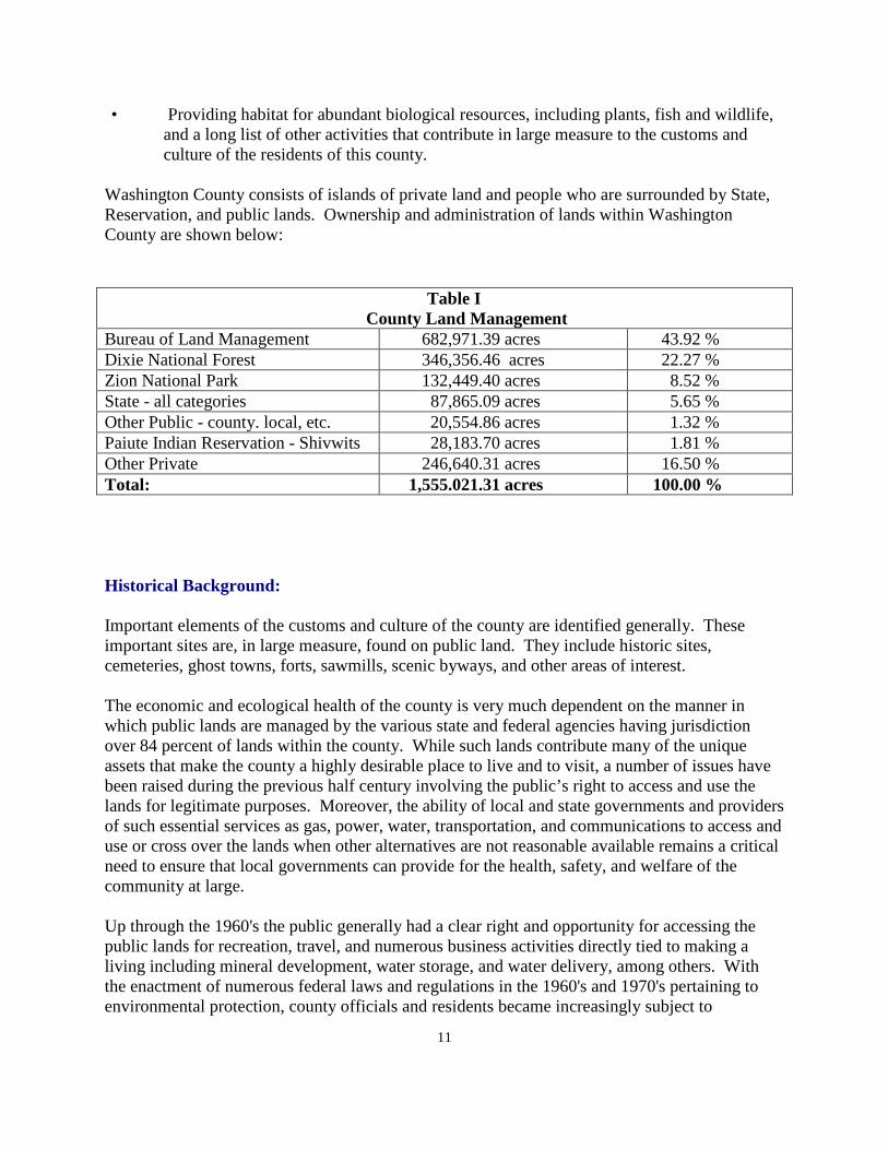
Washington County consists of islands of private land and people who are surrounded by State, Reservation, and public lands. Ownership and administration of lands within Washington County are shown below:
Historical Background: Important elements of the customs and culture of the county are identified generally. These important sites are, in large measure, found on public land. They include historic sites, cemeteries, ghost towns, forts, sawmills, scenic byways, and other areas of interest. The economic and ecological health of the county is very much dependent on the manner in which public lands are managed by the various state and federal agencies having jurisdiction over 84 percent of lands within the county. While such lands contribute many of the unique assets that make the county a highly desirable place to live and to visit, a number of issues have been raised during the previous half century involving the public’s right to access and use the lands for legitimate purposes. Moreover, the ability of local and state governments and providers of such essential services as gas, power, water, transportation, and communications to access and use or cross over the lands when other alternatives are not reasonable available remains a critical need to ensure that local governments can provide for the health, safety, and welfare of the community at large. Up through the 1960's the public generally had a clear right and opportunity for accessing the public lands for recreation, travel, and numerous business activities directly tied to making a living including mineral development, water storage, and water delivery, among others. With the enactment of numerous federal laws and regulations in the 1960's and 1970's pertaining to environmental protection, county officials and residents became increasingly subject to
Table I County Land Management Bureau of Land Management 682,971.39 acres 43.92 % Dixie National Forest 346,356.46 acres 22.27 % Zion National Park 132,449.40 acres 8.52 % State - all categories 87,865.09 acres 5.65 % Other Public - county. local, etc. 20,554.86 acres 1.32 % Paiute Indian Reservation - Shivwits 28,183.70 acres 1.81 % Other Private 246,640.31 acres 16.50 % Total: 1,555.021.31 acres 100.00 %
12
restrictions on how, when and where, access to the lands could be made. While the county is fully supportive of land use constraints necessary to protect public health and safety, and to preserve rare natural assets, historical features, and important landscapes, the county has needed the full cooperation and coordination of all affected state and federal agencies to achieve a proper balance between competing demands for use and management of the public lands that surround each of our communities. Other than water storage and transportation, no other issue has caused more concern than that of wilderness designation. In 1976, Congress passed the Federal Land Policy Management Act (FLPMA) which, among other things, required of Bureau of Land Management to inventory all lands under its jurisdiction for wilderness characteristics and to recommend to the Congress, through the President, those lands that should be designated and preserved as wilderness. BLM in Utah completed its inventories of lands, identifying those lands that met the required characteristics of wilderness, and in 1991 submitted its final report to Washington D.C. for further action. The report recommended approximately 67,000 acres of qualifying public lands in the county be designated for management under the Wilderness Act of 1964. While the county expressed some concerns, it substantially supported BLM’s recommendations with only minor modifications. Special interest groups at the state and national level, however, were successful in getting legislation introduced before Congress that would have greatly enlarged upon the acres and numbers of areas to be designated even though the excess acreage did not meet the wilderness definition, and often contained important facilities or characteristics that would make wilderness designation in appropriate. Over the course of many years, the county held public hearings and conducted its own studies to determine the best legislative option to achieve the proper balance for the citizens of the county. The final reports from such studies continued to parallel the BLM recommendations and received support from consecutive Utah Governors. Congress, however, failed to take final action to resolve the controversy and allow the state and county to move forward. “Temporary” restrictions on the federal lands involved in the initial inventories in the form of wilderness study areas remained in place, making it difficult, if not impossible to implement long-term management decisions on each area. Affected BLM lands in Utah remained in limbo, while National Forest System lands in the Dixie National Forest in Utah were resolved. The Arizona wilderness bill included 2,690 acres on the Utah side of the Arizona border in the Beaver Dam Mountains. The Forest Service bill included 50,232 acres in the Pine Valley Mountains in north central Washington County. The final designations were compatible with county recommendations. In 2004, with support from the Utah Governor’s office, the county determined on its own to make one final effort to develop a plan for Washington County addressing not only wilderness, but a number of other areas affecting the county such as utility corridors, rights-of-way, community growth, and other concerns of the county. Details of this study can be found in the section of the General Plan entitled “The Washington County Resource Management Plan of 2009.” The planning effort addressing both wilderness designation and other land use issues, finally reached a climax after years of negotiations in March 2009, with the passage of the Omnibus
13
Lands Bill of 2009 which included a section entitled “Subtitle O,” - Washington County, Utah. After 33 years of significant time and effort on the part of county officials, staff, and many others, Washington County finally had legislative decisions relating to many of the important issues affecting the interaction between the needs of the county and the federal land management agencies. In passing the county land bill, Congress made the following statement in Section 1792(c)(1); “Congress finds, that for the purposes of section 603 of the federal land policy and management act of 1976..., the public land in the county administered by the Bureau of Land Management has been adequately studied for wilderness designation.” The county strongly endorses that statement by Congress. This General Plan does not support adding more wilderness areas in Washington County. Lands within the county’s jurisdiction have been studied “ad nauseum,” for the past three decades. It is now time for the county and the federal agencies involved to learn how to administer the lands designated, and to effectively integrate them into the wide spectrum of land uses within our jurisdiction, including the multiple use and sustained yield mandates provided by federal laws as they pertain to the public lands. The county maintains that it is critical for federal agencies to use their available resources to accurately survey, map, and sign all wilderness boundaries so that the public at large will be well-informed of the established boundaries, and those readily apparent conflicts to be resolved ahead of time to simplify administration and implementation. Moreover, land use restrictions and policies should be amply posted on applicable web sites, title plats, information kiosks, and other forms of media to help visitors and other users avoid conflicts and associated penalties. The rights of private and state in-holdings must be respected unless and until such lands are acquired by the applicable agency through legitimate processes from cooperating owners. The county will be diligent in seeing that provisions of section 1792(b) which pertain to administration of the new wilderness areas, especially the prohibition of “buffer zones,” and restrictions on land uses outside of the designated areas, be fully complied with by agency personnel at all levels. The county believes that properly managed wilderness areas can be an asset to the diversity of opportunities for our residents, including compatible recreation, wildlife habitat improvements, livestock grazing and watershed management, among others. Improper administration and unnecessarily restrictive policies in violation of the Land Bill’s provisions can create long-lasting conflicts, costly and unproductive legal action, and loss of public support. Washington County expects and looks forward to cooperative management and information sharing on all policy development and implementation pertaining to designated areas inside of wilderness areas and adjacent to outside boundaries. Information sharing must take place in all policy development and implementation pertaining to designated areas inside of and adjacent to county boundaries. The Washington County Land Bill: (Title “0") Omnibus Lands Bill of 2009 Because not everyone has ready access to the land bill signed by the President in March, 2009, some of the highlights of the bill will be reviewed as a part of the Washington County General Plan. The entire Bill is included as appendix II to the General Plan.
14
1. The Bill specifically designated sixteen wilderness areas. One 2,243 acre area lies in the Dixie National Forest. A 124,406 acre area is contained within Zion National Park. Fourteen wilderness areas totaling 129,289 were designated on lands managed by the Bureau of Land Management. A summary of each of these wilderness areas is found in Appendix “A” of this General Plan to assist persons not having access to more detailed information relative to wilderness in Washington County. Most of the information is taken from reports prepared by the Bureau of Land Management.
2. Two National Conservation Areas (NCA’s) were designated. One covers lands
within the Red Cliffs Desert Reserve established in 1998 under the Washington County Habitat Conservation Plan. The second area is located in the southwest corner of the State along the Beaver Dam Wash and includes an Area of Critical Environmental Concern (ACEC) that was designated by the BLM in 1999 for the protection of the tortoise and other desert wildlife species. The BLM is required to complete management plans for the NCA within 3 years of enactment of the bill.
3. Uses allowed in the designated wilderness areas and the National Conservation
Areas are addressed as to military over-flights, fire suppression, and road designations, acquisition of state and private in-holdings, water rights, wildlife management, and restrictions on buffer zones. All of the designations described above are withdrawn from the operation of mining and mineral leasing laws and land disposal either by operation of existing federal law or by specific language in the Land Bill. Federal agencies are required to consult and coordinate with state officials on matters pertaining to wildlife management and water development.
4. Approximately 165 miles of the Virgin River and tributary streams in and
adjacent to Zion National Park were designated as components of the National Wild and Scenic River System, the first such designation in the State of Utah.
5. Rights of Native Americans in designated wilderness areas are assured. A 640
acre tract of land formerly managed by the BLM is added to the southwest corner of the existing Shivwits Indian Reservation.
6. Within 3 years of enactment, the BLM is required to prepare a comprehensive
travel management plan for public lands in Washington County that, among other things addresses a system of roads, trails, and areas for motorized and non motorized use. The plan is required to designate a linked trail system across BLM and National Forest lands known s the High Desert Trail for motorized recreational vehicles. The General Plan also identifies and recommends alternatives for a northern transportation corridor in the county.
15
7. The Land Bill states proceeds from the sale of public lands by the BLM, where identified for disposal in its 1999 Resource Management Plan, will be applied to the purchase of non-federal lands inside the wilderness areas and NCA’s.
8. The BLM is responsible to identify and manage areas in the county where
biological conservation is a priority and is authorized to establish cooperative agreements with, and provide grants to local, state, and tribal entities for research and management in such areas.
9. Also, the Bureau of Land Management is required to convey title to
approximately 353 acres of public lands in the county to five public and municipal entities for parks, schools, and correctional facility expansion.
10. Disposal of some public lands for various types of development.
Various aspects of the Land Bill will be discussed further in the General Plan dealing with specific public agency plans. With the recent approval by Congress of the Land Management Plan, the BLM has much work to do to comply with the elements of Congressional action. Following this general overview of the public lands, the General Plan will look in some detail at each of the public agencies involved with public land management in the county. A summary of each of each of these wilderness areas is found in “Appendix A” of this General Plan to assist persons not having access to more detailed information relative to wilderness in Washington County. Most of the information is summarized from the environmental impact reports issued by the Bureau of Land Management. Historic Sites: Some of the most important aspects of the customs and culture of Washington County are found in the remnants of many early settlements created by early pioneers. Rather than review these in a separate section of the General Plan, they are discussed in this section of the report because many sites are found on Bureau of Land Management or Forest Service land, or, are surrounded by public land which require cooperation and coordination on the part of the public agencies in order for the residents and visitors to have any chance to visit these important historic locations. In a few instances, the agency has transferred ownership to local jurisdictions, but without assistance from the public agencies, some would be difficult or impossible to visit. These sites are listed as follows:
1. “Ghost Towns” There are many Ghost towns in Washington County. In reality, these towns are remnants of settlements by the original pioneer settlers of Washington County. Following is a list of some of the more prominent ghost towns presently existing in the unincorporated portion of the county. Most are surrounded by public land. Many of these towns are found along the Virgin River. The reason that most of
16
the towns are no longer there is also because of the Virgin River. The river could not be controlled, and flooding washed out dams and irrigation ditches. Most of the settlers finally gave up and moved to other locations. a. Duncan’s Retreat is the remnants of a small community along the banks of
the Virgin River between Rockville and Virgin. There were as many as 80 people there at its peak, most of the town has been eliminated by changes in the channel of the Virgin River, which is also the main reason the town no longer exists.
b. Grafton is the next ghost town going upstream, along the Virgin River. Grafton is on the south side of the river and there are still two or three remnants or the town remaining. The school/church is owned by the county and has been restored in recent years. Two or three of the original homes are still standing, and at least one has been restored. Access to Grafton is through the town of Rockville.
The General Plan suggests that a pedestrian access be developed on the south side of Highway 9 with an access foot bridge leading to the Grafton town site. This could provide an enhancement to the scenic highway designation of Route 9, and also provide security against the vandalism that takes place at the town site. The area is mostly privately owned and is jointly managed by the Grafton Heritage Partnership.
c. Continuing up the river are the towns of Shuensburg and Northrup. They were located on the east fork of the Virgin River and are presently located on private land with no public access. These towns disappeared because of the same reason the towns on the lower River disappeared. It is because of flooding on the river, and having most of their farmland and irrigation ditches washed out from the floods that these towns disappeared. The local historical society should seek access to these sites for the use of the general public.
d. Harrisburg is located along I-15 Freeway just south of the town of Leeds.
At its peak in 1868, about 25 families lived there. Because of floods on Ash and Cottonwood Creeks, most of the residents moved north to what is now the town of Leeds. There are still two original homes in Harrisburg. The Orson Adams house on the west side of the freeway has been restored by the BLM, with help from Washington County.
e. Silver Reef is located adjacent to Leeds. Silver was discovered in this
location in about 1871- 1872, which was the beginning of a prosperous run lasting until approximately 1900. Silver Reef was a bustling community at its peak with many types of stores and businesses existing there. Silver Reef provided a sale for many of the agricultural goods produced by the surrounding pioneer communities.
17
The town-site is presently owned by Washington County. There are three or four buildings standing. A map exists showing the location of each of the original buildings at the Reef. It is estimated that as much as $10,000,000, in silver was taken out of the mines during its original days of operation. There have been some attempts to again utilize the mines in more recent years, but have not been overly successful. The General Plan recommends that the county pursue further restoration if the ghost town or perhaps private investments could be made to continue to restore this once significant part of the history of the county. The area has a colorful history with many fascinating tales relating to what happened there over the years of its existence.
f. Hebron was another ghost town located along Shoal Creek lying west of
the City of Enterprise. The originally settlers of Hebron, attempted to live the United Order wherein everyone living there shared everything they had in common. The experiment was not successful and most of the residents moved elsewhere. Hebron has had some new life in recent years as a summer home area with new homes being built. The land around Hebron is part of the Dixie National Forest.
2. Cemeteries:
Early cemeteries have also become a part of the customs and culture of the county. There were likely cemeteries laid out in connection with most, if not all, of these early community developments. Some of the more prominent cemeteries include the following:
a. The Grafton cemetery is located at the edge of the town on Bureau of Land Management land. The Grafton Heritage Partnership and descendents of the original settlers maintain the cemetery and keep it up. The cemetery is available for the public to visit.
b The Harrisburg cemetery sits adjacent to the frontage road on the east side
of the Interstate Freeway. This site is adjacent to a more recent development of travel trailers used primarily for residents who come here for the winter. The actual Harrisburg subdivision where homes were built lies west of the Freeway, and is now part of the Red Cliffs Desert Reserve.
c. At Silver Reef, there are actually two cemeteries located on a side road
away from the town site. One of the cemeteries was for the Catholics, the other for the Protestants. These cemeteries have been deeded from the county to the town of Leeds for upkeep and maintenance.
d. Hebron also has a cemetery located in this town. It is kept up by relatives
of those buried there.
18
f. One other notable cemetery is the one in Pine Valley. This cemetery is still used regularly by descendents of the settlers of Pine Valley, and by others who have moved to the area in more recent years. The cemetery was located on the National Forest, and has more recently been deeded to the Pine Valley Special Service District for upkeep and maintenance.
3. Scenic Byways:
There are two scenic byways in Washington County. One is the road between Rockville and Apple Valley which is a county maintained road located mostly on Bureau of Land Management land, and so identified as a scenic byway by the BLM. This roadway begins by crossing the only remaining historic bridge across the Virgin River in the town of Rockville, and climbing out of the Virgin River Valley to intersect with State Highway 59 at "Big Plain Junction" in the town of Apple Valley.
Part of the roadway between those two towns is in the unincorporated area of the county. That section of the road, a difficult section to maintain, is maintained by the county.
The other scenic byway is on State Route 9 between LaVerkin and Zion National Park. This is a Utah State Highway scenic byway, and is discussed in connection with the transportation section discussing major highways in the county.
4. Other important historic sites.
There are many other important sites in Washington County, both in the various cities and towns as well as in the unincorporated areas of the county. Some of these sites are found on private land, and others are on public land. The purpose of the General Plan is to recommend that all such sites be preserved, and made available to the residents of the county, and to visitor's who come to the county to visit.
a. Fort Pearce is located in Warner Valley, near the Arizona border on the
road between the Washington fields and the Sky Ranch development. The historic fort is no longer standing and only the remnants of the original fort remain. Fort Pearce was constructed during the pioneer days to help protect the livestock of the pioneers from marauding Indians running off livestock. The Navajo's were considered to be the ones who created the most damage to pioneer herds. The purpose of the fort was to alert the settlers when Indian groups were coming into the area to warn them to protect their livestock. After peaceful settlement of Indian problems, the fort was not as important as it was originally. It is still an important part of the customs and culture of the county.
b. Dinosaur Tracks are located on BLM land along the same road as Fort
Pearce, mentioned above. In this location are found some definite tracks left behind by the era of Dinosaur's, and are of special interest to see.
19
c. Santa Clara River Reserve has been more recently developed in an effort to protect Indian writings located on the south side of old highway 91 immediately south of the City of Ivins. This project is on BLM land with the ultimate intent of making this location an attractive visitation element in the county. A committee of residents from Ivins and Santa Clara has been involved with the BLM in identifying this site and making plans for its preservation, called the Santa Clara River Preserve. The General Plan recommends the continuation of this effort.
d. The Honeymoon Trail is a trail up and over the Hurricane Fault by which
settlers in the Kane County area came to St. George once a year to bring materials to sell or trade, and also brought young couples to visit the St. George Temple to be married. The actual trail over the fault line is primarily across the border in the State of Arizona, but nevertheless has significant historic value to the residents and visitors to Washington County.
e. Sawmills were originally constructed in Washington County to provide
construction materials to build the pioneer cities and towns during early settlement. Some of these were in the National Forest where most of the larger timber is located. Another area where much of the timber came from was the Mt. Trumbull area from which much large timber was obtained for most of the large buildings in the territory, such as the St. George Tabernacle and the St. George Temple. The most notable sawmill on BLM land was located on Canaan Mountain. This location is discussed in more detail in connection with the discussion of the Canaan Mountain wilderness area.
The General Plan recommends taking whatever steps may be necessary to protect the preserve the various historic sites that have been identified herein, along with others that may not have been specifically identified. There are many other aspects to life in Washington County that qualify as a part of the customs and culture of this county including such important areas as education, music, theater, writing, dance, and these type of cultural activities. They are not specifically mentioned in this plan except to say that these things have been important elements of the customs and culture of the county since the first pioneer settlers entered the valley, and for the most part, are being protected by various historical and other interested groups in the county today.
20
Section III.
The Bureau of Land Management
General:
There are 630,282.34 acres of land in Washington County under the jurisdiction of the Bureau of Land Management. This amounts to nearly 41% of the total land area in the county, and is easily the largest block of public land. The BLM land area is almost double the amount of land managed by the Forest Service and more than 2-1/2 times the amount of privately owned land in the county.
The Bureau of Land Management comes under the jurisdiction of the Interior Department and is guided by the Secretary of the Interior. There is also a State Director at the state level, and the county land is also currently overseen by the District Office in Cedar City. This multi-level of management often complicates the problem of dealing directly with the manager of the St. George field office. This leads to challenges on the local level of dealing directly with those that have the most interest in what happens in Washington County.
The county, as a result of adopting the Washington County General Plan, makes it known that the county expects to have a "seat at the table" with the BLM in making decisions that impact this county. In recent years, the county has had a fine relationship with the local BLM office. The county would expect that this type of relationship will continue well into the future.
This county is affected by what happens on BLM land more than it is with any of the other public land management in the county. Alternately speaking, there are many special interest groups would also like to be able to influence the BLM in support their various positions while special interest groups generally have a narrow focus and limited official responsibility, if any. The county has numerous functional duties to its residents that require meaningful and practical interaction with the public land and its managers.
One major concern of Washington County is the development of a county-wide transportation plan. The county desires to work closely with the BLM in developing this transportation plan inasmuch as most of the land in the county where the residents reside is surrounded by BLM land. It is not possible to develop a plan for the county without coordination with the BLM.
While transportation in the county also involves the other public agencies as well s the BLM, so much of the county plan is dependent upon planning by the Bureau of Land Management, the General Plan has chosen to discuss transportation in this section of the General Plan. It is recommended that all other agencies review this section of the BLM plan, as well as for private land developers and city and town leaders to familiarize themselves with the Washington County transportation plan. This section of the General Plan dealing with transportation is cited frequently in nearly all of the other sections of the plan.
21
Transportation:
One of the most important aspects of planning on the BLM land involves transportation planning. In the context of the Land Bill, the BLM is required to prepare a transportation plan for the BLM land within the next 3 years. Washington County is developing a transportation plan for the County which includes roads on the BLM land. The county desires to work closely with the BLM in their development of such a plan.
This phase of the General Plan considers the impact of the Bureau of Land Management land on transportation into, out of, and within the county. To drive through Washington County requires driving over BLM lands. It is not possible to drive far within the county without driving over roads crossing BLM land. Therefore this section of the General Plan will analyze the various levels of roads in Washington County, and contains a written text and transportation maps. Much of what is discussed regarding the transportation plan of the county also applies to the section of the plan dealing with the Forest Service, and to a lesser extent, to the National Park. There are identified in the General Plan four types of county roads. These four types are Arterial Highways, Collector Roads, Special Purpose Roads, and other roads not otherwise classified herein. The roads depicted are shown without regard to the underlying land ownership or maintenance responsibility.
Because most of these roads are on public land, not controlled by Washington County, Washington County is not always able to control or influence the condition, maintenance, or ability of the public to travel all of these roadways. Some roads shown may be for special purposes which may result in access being closed to the general public. Many of these roads are not accessible by traditional vehicles including two-wheel drive sedans. Local inquiry with the county or with the public agency involved should be made before venturing out into the “back country” of Washington County. Simply because a road is shown on a county or public agency map, does not mean that it is open to travel by the public in all types of vehicles and under all conditions. The arterial highways essentially include all of the State and Federal highways that pass through the county even though these roads are not maintained by the county. Some county roads are also included in this list. This map includes all of the roads that are included in that category of major arterials and they are identified in the written text that follows.
There are many collector roads in the county. Some of these are classified by use, others by location and by the part that they play in providing a county wide backbone of necessary transportation routes through the county. Right-of-way width may vary on the collector road system. These roads are also shown on the map. They are not individually listed in the written text of the General Plan because of the difficulty of properly describing each one.
There are many types of special purpose roads existing on the Bureau of Land Management, and Forest Service land in the county. These roads provide essential access to mining and mineral
22
sites and claims, locations of sand and gravel resources, water catchments, springs, livestock facilities, recreation sites, private property, School and Institutional Trust Land property, and other such locations serving the needs of county residents.
The special purpose roadway map does not attempt to identify each and every roadway existing on the public land in the county. There are many roadways existing but not specifically classified that also provide access to areas of importance to county residents. The maps that are shown as a part of the General Plan do not in any way attempt, or suggest, that roads not classified should be abandoned or closed by the BLM. In fact, the county would expect that the BLM would coordinate and discuss any proposed closure of roads in the county with county officials prior to any closures taking place.
Except for the major arterials which are shown for continuity purposes, the county road plan does not attempt to show most roadways within the incorporated cities and towns. Some are shown to provide continuity to roads running through the incorporated area of the county to show how they connect to other segments of the roadway in the unincorporated areas. The system of county roads is discussed in more detail as follows:
A. Major Arterial Highways:
1. Interstate 15 Freeway:
The I-15 Freeway is one of the most important transportation routes across our entire nation and travels through major cities including Los Angeles and Salt Lake City. This freeway carries millions of vehicles each year through the county. Much of the original right-of-way through unincorporated parts of Washington County is on BLM Land.
2. �Old Highway 91":
Prior to the completion of I-15 in 1973, the main transportation route through Washington County was on U.S. Highway 91. Occasionally, traffic is shut down on I-15 because of an accident in the Virgin River Gorge. It is then funneled across the old U. S. highway, now a county road, to allow traffic to keep moving while I-15 is closed. It is critical to keep this highway open and in good repair. It comes through the Beaver Dam area from Arizona, crosses Utah Hill, and the Shivwits Indian reservation, and then drops down through the communities of Ivins and Santa Clara, rejoining I-15 again at St. George, Utah.
3. State Highway 18:
This State Highway links the St. George valley to the northern end of Washington County at the City of Enterprise, then into Iron County, linking with I-15 at Cedar City. It is an important north-south route through the west central part of the county. It is gradually being widened and should be a four lane highway from St.
23
George to Enterprise at some point in the future. The General Plan supports its continued widening and improvement.
4. State Highway 9:
This State Highway links I-15 with Zion National Park and Kane County part of the highway has been designated as a State "scenic byway� and is considered for national designation. Much of this highway is located on BLM land. This 54 mile long route follows the path of the Virgin River, and winds through small scenic towns as the primary approach to Zion National Park. It contains views of the towering cliffs that are within the Park. The General Plan supports this designation and encourages further enhancement of this route to Zion National Park.
5. State Highway 17:
This short stretch of roadway across mainly BLM land leaves I-15 at Anderson Junction and travels through the town of Toquerville, joining State Route 9 in the City of LaVerkin.
6. State Highway 59: This route begins in the City of Hurricane at the intersection of Highway 9, and continues eastward toward the State of Arizona, and Kane County, Utah by way of Apple Valley and Hildale. It provides an alternate route to Kane County and the State of Arizona without traveling through Zion Park.
7. The Gunlock Road: This road begins at the intersection with old highway 91 and continues northward through the town of Gunlock, intersecting with State Highway 18 on the other end, in the community of Veyo.
8. Highway 120: Highway 120 is a county road running between State Highway 18 in the City of Enterprise and the Iron County/Nevada State line to the west.
9. Old Highway 144: Old Highway 144 is a county road that runs from the intersection with I-15 Freeway and the town of New Harmony in the northern part of Washington County.
24
10. Pine Valley Road:
The Pine Valley road runs between the town of Pine Valley and the intersection of the Pine Valley Road and State Highway 18 at the town of Central. .
11. Future State Highways - yet unconstructed: There are a number of major traffic routes that are necessary to the future of Washington County. The General Plan recommends and supports the construction of each of these future routes at some point in time, and recognizes that a good part of each route will cross BLM land, or be predominantly on BLM land.
a. Southern Parkway:
The Southern Parkway is now constructed from mile post 2 on I-15 Freeway to the new St. George airport. It is planned to continue eastward, around the Sand Hollow Reservoir, and connect with State Route 9 near 3400 West in the City of Hurricane. The General Plan recommends its completion as an important east-west connection between cities in the county. It will provide primary access to the airport from the east side of the county.
b. Western Corridor:
Part of the Western Corridor alignment has been identified from Snow Canyon Parkway through the cities of Ivins and Santa Clara. This is an important western link to theI-15 Freeway and is located primarily on BLM land from Santa Clara to the Virgin River crossing, connecting to I-15 at mile post 2. The General Plan supports this �belt route.� This route from Santa Clara to the Virgin River crossing is identified on the county transportation map, and made a part of the General Plan. A preliminary center line alignment was proposed after a year-long study by the Metropolitan Planning Organization with a broad spectrum of input from agencies, cities, and the public. The study was completed to promote corridor preservation until such time as funding was made available to complete the project. The final alignment from Old Highway 91 to the Virgin River crossing will need to be coordinated between the county, the BLM and the Metropolitan Planning Organization.
Neither Santa Clara nor Ivins has the money to build this link without funding from the MPO, or the State. Because of the importance of Old Highway 91 as an emergency bypass from the Virgin River Gorge, it would appear that ultimately, it would be in the interest of the State of Utah to have this link constructed to bypass Sunset Blvd. and Bluff Street,
25
and to get truck traffic using the old highway back to I-15. For these reasons, the General Plan supports its construction in a reasonable period of time.
c. Southern Link of the Southern Corridor
This section of the Southern Corridor was the first section proposed in the county many years ago. It departs from the current Southern Parkway east of the St. George airport at the entrance to Warner Valley. Then the corridor continues eastward through Warner Valley and over the Hurricane Cliffs, continues eastward through the Canaan Gap, eventually connecting with State Route 59 in the town of Apple Valley. This route follows the State line.
This route was originally proposed many years ago as a bypass for truck traffic to avoid the steep drop into Hurricane with the concern for the safety of school children in Hurricane. The General Plan continues to support this bypass route. Significant safety benefits would result from its construction.
The construction of this roadway would also provide a right-of-way for a part of the Lake Powell pipeline as it follows State, BLM, and private land between the Arizona State line and the Sand Hollow Reservoir.
d. Northern Corridor:
As a result of the act of Congress approving the Washington County Land Use Bill, the BLM is required to identify one or more routes making up a Northern Corridor. This corridor would link State Highway18 with Interstate15 Freeway at mile post 13 or some other point, such as a North Leeds interchange. Four alternative routes are identified on the Washington County Transportation Map. The county is prepared to work closely with the BLM to determine the final right-of-way route, or routes. At least one alternative route would pass through a portion of the Red Cliffs Desert Reserve established for the protection of the desert tortoise. By 2030 a Northern Corridor will be critical to alleviate traffic gridlock in St. George City to and from large, growing community development along Highway 18 Residents and businesses need access to I-15 for travel north to Cedar City, Salt Lake City, Provo, and employment centers in the eastern parts of the county. St. George City projected such a corridor in their major transportation plan approved in the mid 1980's. More recently, as a part of the Vision Dixie citizen involvement element of the plan, many citizens show various transportation elements through parts of the HCP. The General Plan
26
believes that such a route is possible with further study by the agencies involved.
B. Collector Roads:
Washington County has a number of roads that are considered to be �collector� roads to collect traffic and move it to and from various parts of the county. These routes are vitally important to the customs and culture of the county, not only in moving people throughout the county, but also in connecting to our neighboring counties and/or states. Without including a specific description of each one, the general Plan supports each of these roadways and supports their continued upkeep and maintenance, either by county equipment, and/or the BLM themselves with their maintenance crews. The county expects to continue to work closely and in harmony with the BLM in the maintenance of these important roadways. The collector roads are not specifically listed in the General Plan text, but are shown along with the major arterial roads on the county map of roads and highways.
The General Plan recommends that the county and BLM re-negotiate their road maintenance agreement once the county and BLM road maps have been completed
C. Special Purpose Roads:
There is another group of roadways in Washington County that contribute significantly to the transportation needs of the County. Many of these roads are an important part of the customs and culture of the county. In their own right, these roads are as important to those that use them as any other roads in the county that have been identified above.
These roads are identified as �special purpose� roads. They may lead to a gravel or mineral deposit, mining claim, water spring or catchment for wildlife, livestock, to private parcels of land, to State Trust Land property, to a scenic overlook or view point, as a shortcut to save traveling miles out of the way to get to a particular place, for general sight seeing in some parts of the county, or to monitor, service, or install a utility transmission line. Most of these roads have been used for generations of time. Not all special purpose roads are open to the general public. Some are closed either on public land or on private land. A limited number serve special needs for maintenance of facilities such as a communication site, city wells, livestock watering places, meteorological stations, stream gauges, etc. Access may be limited to authorized users to protect the facilities from theft or vandalism. However, each, in some way, provides access to land for a special purpose.
D. Roads Not Otherwise Classified:
Some of these unclassified roadways that are not specifically shown on a detailed road map are dead-ended to the spot for which the road was built. Some are �cherry stemmed" into wilderness areas or parcels of multiple use land. Some of these roads are graveled,
27
some are �dirt�, and some may be nothing more than a two track access to a particular parcel of land. All such roads are very important to those that have the need to use them regardless of when they were constructed.
As a part of the update of the General Plan of the county, these roadways are necessary to maintain the customs and culture of the county, and will be considered to be as much a part of the county transportation plan as those shown on the transportation maps. None of these roads should be closed without consultation with county officials.
Financing for road construction and maintenance: For financing and maintenance purposes, the county receives funding for county roads from Federal and State sources. Roads are classified into two categories in counties. Most improved county roads are called class �B� roads. Most unimproved roads are called class �D� roads. Funds for these two categories of roads vary from year to year. The source of funding is the gasoline tax of which the county receives a share based on a formula that considers the type of road and the numbers of miles of roads in the county. The county has taken the position over the years that county roads will be maintained from gasoline tax funds and not from property taxes.
It must also be pointed out by this plan that in hot, dry years, it is counter productive to attempt to grade graveled roads when the county has received no rain. With some rain during the summer months, the road county maintenance crew can smooth out the roads. With no rain, the �washboard� condition of the roads is impossible to control. The Plan cannot guarantee a good amount of rain in July and August when it is most needed for proper road maintenance.
RS2477 Roads:
The 1866 mining law known as Revised Statute 2477 granted rights-of-ways for what are known as “RS2477 Roads.” A great many roads in Washington County and elsewhere were created under this authority and remain in use until this day. The statute was repealed in 1976 under the Federal Land Management and Policy Act, but existing rights were preserved. State and local governments, under Utah State law, have the right to administer the use and maintenance of roads created under the statute. Over the years much controversy as various entities, including the federal government, have attempted to close such roads without the consent of the governing local or state authority. The General Plan supports the retention of such roads where legitimate use and rights remain in place. Throughout Utah, many claims for and against R.S. 2477 rights-of-way have been taken to federal court with mixed results. The General Plan supports Utah's efforts to get the matter to the U.S. Supreme Court with the goal of obtaining a definitive ruling and settlement on the matter.
In the meantime, Washington County has prepared a transportation plan of roads for use in this county without regard to specific status. If a road of any of the categories discussed in this plan is needed as a roadway, for legitimate purposes, it should exist and be retained regardless of the category or type of roadway.
28
If a roadway is not needed, it may be subject to abandonment and closure. It is the intent of the county to coordinate closely with each of the public entities to develop a plan for roads in Washington County that the BLM, as well as other public and private entities can support. The traveling public is not concerned with legal details regarding roadways, only that they be maintained and available for use by the public. The General Plan supports this position, and looks forward to coordinating the county plan with each of the public agencies. Utility Corridors: There are many major utility corridors running through and within Washington County. In the 1980's the Intermountain Power Agency made application for a 500 kW power line through the county from the power plant north of Delta, Utah to the Nevada border north of Mesquite. There was much discussion at the time as to whether to allow narrow, individual corridors or to have one wide corridor for the power line and any other subsequent utilities that might also need a right-of-way along the same alignment. The decision was made to have a single corridor. Since the original power line, there have been two underground natural gas lines in the same corridor as well as a second power line and a fiber optic cable. Moreover, there is another underground line, a refined petroleum line, currently being proposed. The General Plan supports the continued use of this corridor for major utility lines and the continued maintenance of the current one mile width of the corridor for future utilities that may need a corridor through the county. The General Plan would support expansion of this corridor as necessary in the future. The southern portion of this corridor has also been identified as the logical right-of-way for the High Desert Trail identified by Congress in the 2009 land bill. Another major utility corridor contains the Navajo 500 kV power line that is located in the southern part of the county as it goes from the Navajo generating plan near Glen Canyon Dam through Washington County and into Arizona and Nevada. All such corridors should remain available for additional utility systems. Both corridors are designated in BLM's 1999 St. George Field Office Resource Management Plan and the Department of Energy's Utility Corridor Plan and Environmental Impact Statement. Other major utility corridors include power lines from the Red Butte sub-station at Central, leading to southern Washington County. There is also a natural gas line parallel to Highway 18. Another major utility corridor is located on the southeast side of the Pine Valley Mountains to serve areas in the eastern part of the county with electricity and with natural gas. Other lines run toward Springdale, Hildale, etc. There are a number of electric companies that wheel power to sections of Washington County and serve the residents therein. Many cities have their own power company. Attached is a map that shows all the existing major utility corridors within and through the county. Corridors are shown for future transmission projects that are proposed, but not yet developed. The General Plan supports the creation of transmission corridors for the future lines needed to serve the residents of the county. The plan recommends the public agencies work with all future company needs in providing utility corridors for electric, gas, fiber optics, or oil transmission facilities that will be needed in the future.
29
Included in this recommendation is the need for the site location of transmission towers for cellular telephone transmission, and other types of transmission systems including such things as radio towers, hydrologic and air quality testing facilities, and high speed internet transmission lines. These sites are not specifically shown as a part of the utility system map, but equally important to the future of the county. Earthquake measuring devices and other similar testing equipment that may also be located in the county in the future, and are encouraged to be approved by the public agency by the General Plan. The county is particularly concerned that major communication sites existing on west mountain and scrub peak continue to be authorized by the BLM, and employed to their maximum potential. Almost all law enforcement in this county and northern Mojave County, Arizona, is dependent on these sites for area-wide communications. Public safety is at stake if use is curtailed at either site by restrictive land designations. Trails: Trails have become an important part of the exceptional quality of life and livability of Washington County and are a major draw for tourists and residents alike. Numerous trail systems have been completed by city planers within incorporated limits with the intent to link with trails in adjoining communities to make an unprecedented trail system allowing non-motorized commuting in addition to extraordinary recreational opportunities in the urban zone. Outside of the communities, the county has worked with public agencies to foster over 200 miles of trails and numerous trail heads, the majority of which link with those coming out of the cities and towns. The overall goal, as established by the Three Rivers Trail Initiative, is to create a fully linked trail system allowing continuous travel on authorized trails from the Shivwits Indian Reservation on the west to the south entrance of Zion National Park on the east. Funding for most of the trail components has come through the Utah Division of Parks and Recreation with matching contribution from local agencies and towns. The General Plan supports the completion of this system along with other trail developments including the High Desert Trail system that is called for in the Land Bill. In the unincorporated area of the county there are basically two types of trails. They include:
1. Trails for use by hikers, horseback riders, mountain bikes, or users of non-motorized vehicles. Many trails of this type are located in the Red Cliffs Desert Reserve, as well as in other areas of the county. These trails are well used by this segment of the population. 2. Trails identified as being open to motorized vehicles. This may include 4-wheel - drive vehicles, off-road vehicles, and any other type of motorized recreational vehicle. County ordinance identifies all roads in the county as open to this type of vehicle unless otherwise shown as being closed. One of the most important such trail is the High Desert Trail, as identified in the Land Bill. This trail is a part of a multi-county trail that serves a large number of counties in the State. The southern end of this trail here in Washington County ends up at the Nevada State Line and will be extended further from there into the State of Nevada.
30
The county has been involved with the trail alignment for this trail for a number of years, particularly on forest land, and is happy to continue to work with the public agencies to see the right-of- way indentified and the trail constructed. There is a map included in the General Plan showing the major routes for motorized vehicles and for non-motorized vehicle travel. The State Division of Parks and Recreation has just completed a very thorough map showing motorized trails in Washington County. The General Plan endorses this plan, though some corrections will show on the map included in the General Plan. The General Plan offers a strong word of caution, particularly to the users of motorized trails and roads in the county. There are many roads and trails that are available for use. The county will do all that it can to see that these travel ways are kept open and available for use. However, as the use of motorized vehicles continues to increase as a measure of recreation in the county, the General Plan recommends that recreation groups, particularly, undertake educational programs with residents of the State who may come here, to encourage users to use roads and trails that are designated for use, rather than opening new roads and trails that do not currently exist. Nothing will cause the public agencies to close some of these trails more quickly than the abuse of the right to use them in a respectful manner. This means staying on the existing routes, of which there are many, not creating new routes that do not currently exist, keeping them clean by leaving no trace as to where the vehicle has been, and simply being a good user whenever out on the public lands on a recreational type vehicle. Use these routes wisely. The public must patrol itself. Other Areas of Needed Cooperation and Coordination: There are many elements identified in the current Bureau of Land Management St. George Field Office Resource Management Plan that Washington County is, and has been, in support of since its adoption. The county does not support these elements being amended or changed in any significant manner without the county being fully involved in such changes. The county has enjoyed excellent cooperation with the BLM for the period of this resource management plan. It is not the intent of this General Plan to include all of Chapter 2 of the BLM Resource Management Plan into the General Plan of Washington County. However, many, if not most of the policies in that Plan are still viable to Washington County and should still be followed. The plan will attempt to identify many of the subjects covered and will look forward to discussing any changes that may be proposed in the future to these various land use categories which are listed as follows: Land exchanges - would be permitted on land not specifically identified for exchange or disposal if such changes are determined to be in the public interest and would accommodate the needs of local and state governments including needs for the economy, public purposes, and community growth. Lands previously identified for transfer, but not yet transferred, and which may be available through the approval of the land use plan by Congress, are identified for acquisition as well as lands identified for recreation and public purposes, where known.
31
The preservation of scenic Route 9 has been discussed elsewhere, but is identified in the BLM Resource Plan as being retained to enhance the scenic corridor. Additional utility transmission in the already designated utility corridor to serve the eastern part of the county may, however, still be necessary in that area in the future. Trespass on public lands may be best settled by exchange for equal or better value in areas supporting significant resources. Where easements are necessary to provide public access to important use areas on public lands, the BLM Resource Plan should continue to make public lands available for such purposes. Where possible, sponsors should locate rights-of-way in existing or designated utility corridors. Public lands are generally open to new rights-of-ways. Applications would be considered on an individual basis. The BLM Resource plan identifies known and proposed utility routes. The County General Plan also identifies known routes and currently known future routes for roadways and utility corridors. Such corridors would generally be one mile wide but could vary according to topography, etc. The General Plan recommends that this width be maintained and that the county be involved in discussing areas where this width might need to be modified. New routes for major roadways such as the connection from Highway 59 at Apple Valley to I-15 and on to Ivins and Santa Clara will be considered. This route would allow for heavy truck traffic and through traffic to bypass congested urban areas and to resolve growing public safety issues. The County will work with the Metropolitan Planning Organization in both the eastern and western parts of the county to identify existing major highways and proposed future major highways and to include them in the General Plan. Energy and mineral resources are critical to the future of Washington County. Of particular importance is sand, gravel, and cinder sources for construction purposes. The General Plan will work with the BLM to identify as many such sites as can be identified in the county in order that these areas can be protected from closely developed residential uses. This can be done by county zoning ordinance to protect future sites, even though actual development may not be needed in the immediate future. The General Plan recommends that these valuable mineral uses be given strong protection. Some sand and gravel sites may, of necessity, be located in proximity to already developed residential areas. There may be other minerals in the county, including solid and fluid minerals, and wind and solar development in areas identified for multiple uses on the BLM lands. The county will work with the BLM when such areas are proposed for development to provide the needed access for utilities, and other needs, depending upon the size and scope of the project. The use of such areas for development when properly identified and planned is supported by the General Plan in multiple-use areas of the county. "It is BLM's objective to continue to work closely with Washington County officials to ensure that use and enjoyment of existing roads and trails is permitted under safe and prudent conditions. It is also BLM's objective to work with municipalities, transportation and other
32
affected parties in defining and planning for future transportation systems where public lands are involved," according to the BLM Resource Management Plan. The county supports this policy. The present Resource Management Plan provides the basis for close coordination with the county in developing and updating a county and BLM road management plan that can serve the needs of both the county and the BLM. Such a plan is mandated by the bill from Congress. It has been identified in many places in the General Plan that it is the goal of the county to work out a transportation plan that both entities feel comfortable with. Relative to soils and watershed protection, the General Plan quotes a statement from the Resource Management Plan which is supported by the General Plan. "It is essential that BLM work collaboratively with local, state, and other federal agencies, Indian tribes, user groups, university researchers, and diverse interested publics to develop plans and implement approved recommendations to achieve a sound balance in how resources are used to meet the community's needs and to support the conservation of natural resources in the county." Any changes regarding water development, water shed plan, and soils, should be coordinated with the County prior to any change being made consistent with the General plan. The Land Bill for Washington County also designated a number of river segments in the north drainage of the Virgin River as being wild and scenic rivers. Most are located in the Kolob area of the county north of Zion National Park. Washington County should be closely involved with the BLM in developing specific management policies for these stream segments. Most of the segments are within, or adjacent to, identified wilderness areas. The county is interested in the management policies for these stream segments as they are developed by the BLM and in harmony with the General Plan of Washington County. The Lake Powell Pipeline was not specifically identified in the current management plan of the BLM because no specific proposals had been made to BLM at the point in time that the resource plan was completed. The General Plan supports the development of this critical future water source for Washington County, and the proposed alignment of needed pipelines to support its development. The County will work closely with the BLM to review and approve the proposed or amended right-of-way to deliver additional source of water to Washington County. The development of additional water resources also calls for the development of additional water storage facilities. The General Plan supports all current and proposed water storage reservoirs throughout the county as they may be identified in the future. Two known sites include the Anderson Junction site and another site at the head of Warner Valley. As other sites are proposed and identified, the General Plan recommends that the County General Plan and the BLM Resource Management Plan be amended to include these additional reservoir sites as they may be identified for development. The proposed plans shown in the Resource Plan may have been modified over the years. The county will work with the BLM to make sure that this plan is updated as needed. There are significant riparian resources in the county with many such areas on BLM land. The county will work closely with the BLM to review these areas, as well as vegetation resources, special plant varieties and animal species that are identified in the Resource plan.
33
The Habitat Management Plan was adopted by Washington County in 1996. The plan is in place for a twenty year period of time. At the present time, the plan appears to be well managed and is cooperating with the state and the various communities to the extent possible. The General Plan proposes that the plan be continued in its current makeup for the balance of its originally stipulated existence. It is the recommendation of the General Plan that a "seamless" transition be made between the current HCP and the National Conservation Area created for the same areas as the HCP as a part of the 2009 act of Congress. The HCP is working well, the current "players," meaning the public agencies, is functioning well. This organization would appear to be the same organization that is needed to carry this plan forward beyond the 2016 expiration date of the HCP. On March 30, 2009, the President of the United States signed an Omnibus Lands Bill that, among other things created the Red Cliffs National Conservation Area in Washington County. The NCA was the outcome of many years of work and implementation associated with the Washington County Habitat Conservation Plan (HCP) which had previously designated approximately 62,000 acres of land in the county as the Red Cliffs Desert Reserve. The county worked closely with the U.S. Fish and Wildlife Service, the State of Utah, the Bureau of Land Management, and several participating municipalities to implement and manage the reserve for the purpose of recovering the threatened desert tortoise and other species at risk in the St. George urban corridor. That effort required extensive coordination and planning using the talent and resources of all agencies and partners involved. A multi-agency group served as the coordinating committee which advised the county commission on all matters pertaining to the use and conservation of lands within the reserve. Under the terms of the HCP, representatives of key user groups and community interests were involved in all phases of implementation and management. It has served as a highly successful model for similar efforts taking place throughout the western United States. To provide a permanent protection for the desert tortoise after the USF&WS permit expired and/or recovery objectives were achieved, the HCP called for the creation of a national conservation area. The goal of the General Plan is to continue the highly collaborative process currently in place in the development of planning, management strategies, and administration of the NCA. In addition to the 1995 HCP and the 1996 implementation agreement, current direction for use and management of the reserve is spelled out in great detail by the public use plan approved by the commission in June of 2000, and formally adopted by the BLM in 2002 after extensive public input and NEPA analysis. The county expects, and the General Plan strongly recommends, that the documents cited above continue to be the basis for the day-to-day management of the new NCA and the county plans to continue to make its resources available to support a collaborative approach in developing the NCA management plan called for in the legislation. Moreover, it is essential that the federal government recognize the Section 10 permit issued to the county under the Endangered Species Act, and support all provisions of the HCP developed in support of the permit. The economic and ecological well being of the county is dependent upon this plan and its continuation. The Omnibus Lands Act of March 30, 2009, also created the 68,000 acre Beaver Dam Wash NCA in the very southwest corner of the county. The act states that the purpose of the NCA is "to conserve, protect, and enhance for the benefit and enjoyment of present and future
34
generations the ecological, scenic, wildlife, recreational, cultural, historical, natural, educational, and scientific resources of the NCA." The area designated overlaps the BLM's Beaver Dam Wash area of environmental concern and numerous other public lands used for grazing, outdoor recreation, wildlife habitat, watershed, the major utility corridors, a major transportation corridor, and desert research. The NCA includes private lands, numerous state owned lands, BYU's Lytle ranch facility, the Joshua Tree National Natural Landmark, the Woodbury Desert Study Research Area and significant amounts of desert tortoise critical habitat. The Kern River corridor is a nationally significant corridor that contains multiple high voltage transmission lines, gas lines, and fiber optic lines. The corridor is designated in BLM's 1999 St. George RMP, and in the Department of Energy's Westside Corridor Plan and EIS. It forms a major route for transmission of fuel and electricity from the Intermountain Region to major markets in southern Nevada and southern California. It is also the likely corridor to be used for transmission of electricity emanating from planned and potential wind and solar facilities in Utah and Wyoming, including Washington County. It will be crucial in meeting goals for western states intent on maximizing development of renewable energy resources. Therefore it is paramount that the corridor continues to be made available for the purposes for which it was established. New restrictions on the corridor cannot be justified simply because of the NCA designation. Washington County will vigorously defend the corridor's legitimate use. The General Plan would recommend that the management of this corridor remain under the management of the BLM, outside of the jurisdiction of the NCA. In like measure, it is essential to the health, safety, and welfare of Washington County that physical, motorized access be maintained to all private, state, and federal lands where facilities and operations require such access to continue essential activities, including emergency access for law enforcement, fire fighting, search and rescue, and ongoing economic activity such as livestock grazing, watershed management, flood control, stream monitoring, water developments, communications, and wildlife habitat improvements. Washington County understands the need for special natural area management in those areas of the NCA that have unique values that warrant a light hand on the land. The county does not support, nor can it tolerate, a complete closure of areas to government officials, permit holders, legitimate operators, and the general public simply to satisfy the demands of any special interest group that desires to close public lands to all forms of human use provided for in current state and federal law and existing land use plans. The county accepted an NCA designation on the Beaver Dam Slope in lieu of numerous designated wilderness areas so as to preserve options for compatible uses throughout major numerous designated wilderness areas so as to preserve options for compatible uses throughout major portions of the area. The county is willing and anxious to promote a collaborative approach to managing the lands and resources within the NCA in concert with BLM, the State of Utah, and private managing or lands and resources within the NCA in concert with BLM, the State of Utah, and private land in-holders. That the county is able to do so is amply demonstrated in the manner in which it has led the planning and management of the Red Cliffs Desert Reserve, now encompassed within the Red Cliffs NCA, since 1996. The county will insist that management plans developed for the Beaver Dam Slope NCA give proper respect and consideration to the General Plan and all other applicable state and local plans in accordance with Section 202 of the Federal Land Policy and Management Act of 1976. It is critical that the BLM recognize the legitimate needs of the citizens most dependent on the access to and use of the public lands within its jurisdiction. The county expects that, as the representative of the
35
federal government, the BLM be forthright and early in its notifications to the county as to plans for land use changes in the NCA and involve the county in a meaningful way as a partner in making any such changes. The General Plan supports developed and primitive recreational and organized camping facilities on BLM land. The county will work with the BLM to review the BLM land, and to determine whether or not there may be additional areas that could be developed in the future. Any potential future sites will become a part of the General Plan. Fire Management: Fire management on public land is one area in which the General Plan does not support many of the current public policies for fire management. Fire management on public land includes three general areas. These are discussed by the General Plan as follows: 1. When fire threatens lives, property, or public safety, the county supports the policy to suppress fires that could become a threat to the health, safety, and welfare of the public. This policy should be continued and extended to other management areas, such as those described below. 2. General wildfires include lighting strikes, accidental fires, etc., and prescribed burns. The General Plan agrees that there will be wildfires from time to time, especially in wet summer seasons, and the plan also agrees that from time to time, after consultation with state, local and other federal land managers, that a prescribed burn might be useful in improving range conditions and improving grazing. In past years chaining was also an alternative to prescribed burns. The General Plan recommends that the public land managers look for new and improved means of fire management and suppression that would protect the natural resources, including air quality. The General Plan recommends that in order to protect the health, safety and welfare of the public, wild land fires, with the possible exception of a limited prescribed burn or other types of burns should be suppressed as quickly as possible with the least damage to, and loss of, burned acreage. This policy of fire suppression says nothing about the air quality that was so bad that, from the City of St. George, the Pine Valley Mountains were invisible for days at a time because of the thick smoke from the fire. There was no thought to the protection of air quality for the residents of the county. Local forest authorities could to nothing about the fire because of a faulty federal fire control policy. Another fire that burned at nearly the same time occurred in the new Zion National Park wilderness area. This fire was also very small at the outset, but under federal fire management policy, it was allowed to burn uncontrolled until the fire had burned hundreds of acres, and filled the county with smoke for weeks before the fire was finally suppressed. The General Plan condemns this policy as being irresponsible and adverse to the public interest. It is not in the interest of protecting the general health, safety, and welfare of the residents of this county. Several fires in California had the same effect on Washington County in 2008 and again in 2009.

36
The county finds it reprehensible that the federal government makes a big issue out of using a vast natural resource, coal, to generate power from which smoke stacks produce a plume made up mostly of steam and water vapor, and yet sees nothing is wrong in letting fires burn for days and weeks, which, along with California fires burning at the same time, filled the valleys of Washington County with smoke for months. Through much of the summers of 2008 and 2009 the air quality has been closer to Class IV air than to class I or II. Uncontrolled fires spew more pollutants into the atmosphere when allowed to burn uncontrolled, than a coal fired power plant will contribute during the life of the Power Plant.
37
Section IV. The National Forest: General: Of the National Forests located in the State of Utah, the Dixie National Forest is the largest of the six forests. It covers over two million acres in six counties; Garfield, Iron, Kane, Piute, Wayne, and Washington County. The headquarters for the Dixie National Forest is in Cedar City, Iron County, which is adjacent to Washington County on the north. Of the two million acres in the Dixie National Forest, 346,356 acres of the forest are in Washington County which total a little over 17% of the total Dixie National Forest. That portion of the National Forest in this county is included in the Pine Valley Ranger District and amounts to 22.27 % of the land in the county. The Pine Valley Ranger District, with headquarters in the City of St. George, lies south of the Washington / Iron county line and west of Interstate 15 Freeway, and extends westward to the Nevada border. Included in the Pine Valley District are two designated wilderness areas. These include the Pine Valley Mountain wilderness area designated in 1984, and the Cottonwood Forest wilderness area designated in 2009 as a part of the Washington County Growth and Conservation Act enacted by Congress. There are two wilderness areas together result in over 15 % of the total forest land in the county. Most of the remaining acreage in the forest is classified for multiple use purposes. Next to the Bureau of Land Management, the National Forest is the largest public land holding in the county. The National Park also makes up a large area in the county, as does the collective acres overseen by various agencies of the State of Utah. Each of these areas will also be discussed as a part of the General Plan. Even though there are different public land managers in the county, they have many things in common with each other, including the fact that whichever agencies the county may be dealing with, the same residents of the county are affected by the decisions of the agency. Many years ago the Governor of Utah organized a group named the Southern Utah Planning Authorities Council (SUPAC) for the purpose of resolving problems between the county and various federal and state agencies. The original effort was so successful that the program gradually spread to the adjacent counties making the SUPAC organization essentially a five-county organization. This is not to suggest that the organization has not served a very useful purpose. Regular meetings’ involving the public land managers is a very useful tool in implementing planning efforts in the region. It does no good to work with all of the public agencies in preparing this General Plan, if we never again meet together once this plan and other similar agency plans are completed if they are never again coordinated. Only through regular coordination can any of these plans be successful.
38
It is not the intent of the General Plan to quote the forest resource management plan as a part of this document. The county is generally in support of the resource management plan adopted by the National Forest as it relates to Washington County. There are some areas of disagreement with the forest plan. These areas mostly involve federal directives relating to such things as road less areas, livestock grazing, and fire control over which local ranger districts have no control. The various facets of the forest plan will be mentioned as a part of the General Plan. Where differences exist, they will be identified. In areas where the county is in support of the forest plan, the section of the forest plan will simply be mentioned with no objections expressed. Transportation: Because of overlapping issues facing the county and the public agencies, the General Plan recommends that public land managers read all sections of the plan dealing with the other public agencies. Many issues of concern or interest to one public agency may be discussed in the section dealing with that agency, and issues that will impact other agencies maybe discussed in other areas of the General Plan. Most often these issues are not repeated in the discussion of the plan with each agency individually. One such issue has to do with developing the county transportation plan. A person cannot travel far in this county without crossing lands managed by other agencies. For this reason, the General Plan has spent considerable time in preparing a circulation plan throughout the county. This plan obviously involves land overseen by all public land managers. The General Plan of circulation in the county takes different forms. One transportation map includes all major arterial and collector roads in the county no matter what land they cross. The plan will contain these road maps as a part of each section of the plan, particularly the forest and BLM sections. However, more time is spent discussing where the major roads are located, etc., in Section III than in any other section. The reader is referred to that section to get the most information about roads and transportation. But the questions of roads and their importance relate to each section of the plan because they all relate together into one whole. The General Plan contains the following road maps: 1. Map of Arterial and collector roads. 2. Map of special purpose roads. 3. Map of off road vehicle roads 4. Map of riding and hiking trails that are - non-motorized 5. Map of current and future utility routes These maps relate to all land management agencies in the county. The county is interested in the proper upkeep and maintenance of roads on forest land. The recommendation of the General Plan is that following the approval of this plan that forest officials and county officials meet together to review the maintenance of roads in Washington County and review the maintenance responsibility of the forest service and the county. If revisions need to be made as to who might
39
be responsible for maintenance of a specific roadway, the maintenance agreement should be amended and updated. Changes in the management, maintenance, and classification, of roadway usage are of concern to the county. The General Plan recommends that forest officials and county officials meet to discuss any proposed change to the usage of any road on the forest land, and the change should be agreed upon by both entities before it takes place. The county is willing to meet anytime to discuss forest road issues as a partner in forest management and has appreciated the cooperation and involvement with forest management up to this point, with hope that it will continue. Wilderness: One of the first wilderness designations in Utah was made in 1984 when the top of the Pine Valley Mountains was designated by Congress as wilderness. This area included some 50,000 acres. As a part of the Washington County Growth and Conservation Act of 2009, another 2,643 acres was designated on the National Forest in the south-east corner of the Dixie National Forest adjacent to the BLM Cottonwood Wilderness area and was designated as the Cottonwood Forest wilderness area. All of the other wilderness areas are on Bureau of Land Management land along with most of Zion National Park. The county concurs with the county land bill that the Cottonwood Forest Wilderness area fits well with the BLM Cottonwood wilderness Area. For that reason, the county recommended that it be included in the act of Congress. The county also agreed with Congress that this county has been studied no end for wilderness designations and enough is enough. The General Plan says emphatically, "Study this county no more." The General Plan feels that this statement applies to any and all public land in Washington County. Vegetative, Hydrological, and Geological Features: The variety of vegetation on the forest is reflective of the soils, climatic patterns, disturbance, histories, and elevation of which there is significant variation within the county. Lower elevations contain Pinion pine and juniper with some bristlecone pine in the northwest portion of the county. Other elevations contain ponderosa pine with quaking aspen at the higher elevations. The type of vegetation is dependent upon water and elevation. Elevations in Washington County vary from lows of 2,600 feet near the southern end of the county, to over 10,000 feet in the Pine Valley Mountain area. More recently, as a result of some fires, cheat grass has become the predominant vegetation instead of other historic types of ground foliage. This growth of grass could be controlled by the proper use of livestock grazing in the spring when this grass is still green, and when it could provide forage for livestock. By removing livestock from the historical range, the forest encourages more frequent and more devastating fires in the future. The General Plan does not support the current grazing policies that have resulted in most of the livestock being removed from the public range.
40
Washington County has not seen the same degree of plant loss because of insect infestations as some other parts of the Dixie National Forest have seen. Where insect injury has caused the loss of large trees, the forest should make every effort to harvest these trees to receive some economic benefit from their existence. The average rainfall in the forest areas of the county range from about 8 inches in lower elevations to over 25 inches on higher locations. Precipitation mostly comes from snow in the higher elevations during winter months and from summer storms from mid-July through mid-September. These summer storms are generally associated with lightning which makes these summer months subject to lightning fires and flash flooding which are most destructive to the forest land in the county. The General Plan suggests that such fires can be minimized by proper grazing management throughout the forest. Geographically, the Dixie National Forest is on the divide between the Colorado Plateau and the Mojave Desert. In Washington County the Dixie National Forest lies south of the Great Basin. Wildlife: There is a great variety of wildlife on the forest in Washington County. This includes deer, elk, cougar, and many smaller varieties of animals. While there are a few fishing opportunities on the forest in the county, they are somewhat limited, but good where these opportunities exist. The major fishing activity takes place at the Enterprise reservoirs and the Pine Valley reservoir. There are streams where fishing is available, but it is limited. Many of the streams in Washington County are seasonal and are dry during some months of the year. Many varieties of birds are found on the Dixie National Forest, including Eagles, smaller raptors, and other bird species. Recreation: The forest in Washington County supports a broad spectrum of recreational activities. These opportunities for recreation include camping, hiking, horseback riding, OHV use, hunting, fishing, wildlife viewing, wood cutting, nut gathering, and viewing of scenic landscapes. It is easy to see the importance of the forest land in this county to both county residents and to visitors who come to the county to participate in many of these recreational pursuits. Because of the proximity of the forest land in Washington County to non forest areas in adjacent states where the desert landscape predominates, the National Forest in this county also provides extensive forest experience to many of our neighbors. This further emphasizes the importance of maintaining as much of the forest land as possible for multiple use purposes. The General Plan is very emphatic in declaring that the remaining forest lands in the county continue to remain as multiple use land because Washington County provides forest recreation opportunities not only for our own residents, but for residents of Nevada and parts of Arizona as well. This growing need for forest recreation opportunities, of which the county is already well aware, places a
41
significantly increased demand on the forest land in the county. This issue places additional pressure on the forest wilderness land in this county. One national recreation trail, the Whipple Trail, in the Pine Valley Mountains is on a National Register which attracts many additional forest users to the county than would otherwise come here if the forest use was limited to residents of this county. There are a number of improved campgrounds on forest land in the county. One of these is Oak Grove on the southeast slope of the Pine Valley Mountain. The most prominent site and most heavily used camp ground is the Pine Valley campground adjacent to Pine Valley Townsite. Many of the camp sites in this campground are being re-configured to remove them from live stream and riparian locations. There are some camping facilities adjacent to the Enterprise reservoirs west of the city of Enterprise. Further west near the Nevada border is the Pine Park campground, which contains no water or sanitation facilities. The General Plan recommends that the Forest Service review forest land for the possibility of establishing additional developed camp sites that might could be developed in the county. Obviously, funding to develop camping facilities is a problem. However, if the plan is good, time will provide a way for additional organized camps to be developed. Historic Sites: The National Forest in Washington County also contains a number of historic sites. These include historic town sites such as Pine Valley town, Hebron, and Pinto. There are sawmill sites around Pine Valley, cemeteries in Pine Valley, Pinto, and Hebron, etc., recreation sites, administrative sites, CCC (civilian conservation corps) projects, homesteads, ranches, camps, roads, and trails throughout the forest. The General Plan supports the identification, and preservation, of these sites, and in making efforts to make them more accessible and available for visitation by the public. Some visitors to the forest find solitude in the Pine Valley Mountains or the Cottonwood Forest Wilderness area. Each serves a useful purpose, and is a part of the great variety of experiences that exist in the forest in Washington County. Management Challenges: There are always challenges to the management of the forest land in the county. Some factors include fire suppression, livestock grazing, vegetation changes, introduction of noxious weeds and other invasive plants, and the risk of insect infestation. Washington County welcomes the opportunity to work with forest managers to address these challenges and to assist in finding solutions that will protect the forest resource in the county for continued use by residents and visitors. The General Plan previously recommended steps that should be taken to allow the county leaders to work closely with land managers to continue to establish healthy conditions on the public lands in the county. The county administration is always available and welcomes the opportunity to be a player with the forest managers in continuing to manage this valuable resource.
42
Demographics: The growth in population in the western United States has placed increased demands on the use of public lands. The use of forest land has increased proportionately. Much use comes from growing populations centers in northern Utah and southern Nevada. Washington County is the nearest neighbor to southern Nevada with the recreation opportunities found in the national forest. The demands for use of forest lands are not always compatible. Motorized and non-motorized users are sometimes in conflict with one another. There are many conflicts and challenges brought on by increased population. Washington County welcomes the opportunity to work with forest and all public land managers to meet the challenge of population growth. The forest lands in the county provide a significant economic benefit to the county. This includes food and fiber production, mineral production, and recreation activities that contribute to the sustainability of communities. Sometimes these activities have conflicted with resource goals related to wildlife, watershed protection, and vegetation. The challenge is to manage the forest in a way that continues to provide economic opportunities and sustains the forest system. Water: Most of the ground water sources in the county originate on the National Forest. It may take years for water to percolate through the ground to springs and wells in the lower valleys, but the moisture originates in the mountain elevations. The demand for water resources continues to grow. Water is important to the resources that the forest manages as well as the social and economic opportunities that water provides. It will be a continual challenge to provide sufficient water for healthy watersheds, aquatic species, wildlife, and vegetation, while also providing water for the needs of local communities and traditional rural activities. Washington County, through the Water Conservancy District, is aware of the need to provide additional water sources and reserves for use in Washington County. Benefits could come not only to the residents of the county in the form of culinary water for residential, commercial and industrial use, but also to the public land managers. Additional water could assist in maintaining riparian and wetland areas. The availability of water also improves water tables, and extends mountain streams to the valley floor. It could provide water resources for additional organized campground development, and provide resources for other uses on the public lands. This is a project that the General Plan supports for the benefit of all of Washington County. An important policy on the forest lands is to, "cooperate with states, other federal agencies, local governments, tribal governments, stakeholders, and holders of valid water rights to provide mutually beneficial programs for restoring, maintaining, and utilizing water resources." The General Plan is in support of this policy. Minerals: The number of locatable mineral deposits is generally limited on forest land in the county. If there are developable sand and gravel resources on forest land, these need to be identified for
43
future development as needed. Other mineral development in the county should be done according to current forest policies and guidelines. While timber exists on much of the forest in Washington County, little timber harvesting occurs except for cedar posts, Christmas trees, wood cutting for personal and family use. These uses should be continued. Fire and Fuels: The General Plan went into some detail relative to fire management on public lands in Washington County in Section III of the General Plan regarding BLM lands. Recognizing that current federal laws guide fire management, particularly in wilderness areas, the county is opposed to current policy in order to protect the air quality in the county. The county has adopted the fire management policy regarding defensible space around building development in or near the National Forest. The Forest Service has cooperated with the county in promoting these fire protection policies. The county will continue to work with the forest officials in protecting common boundaries between the forest and private development. Threatened and Endangered Species: With the possible exception of the new Cottonwood Forest wilderness area, there are no tortoises on forest land because of the higher elevations on forest land. The Virgin River Fishes Recovery Plan should also be implemented where applicable to Forest Service activities where feasible. Other T & E species should also be managed on the forest in cooperation and coordination with county officials and other land managers. Rangeland and Grazing Management: Grazing of livestock in Washington County as well as most of the western Unites States has been overseen by federal policy which is basically to remove all livestock from the public lands in this country. Management of the range for the beneficial use of the land by livestock hardly seems to enter in. Invasive species, particularly the cheat grass invasion of recent years could be put to beneficial use through springtime grazing. The management and prevention of infestations of noxious weeds and other invasive plants could be managed through proper grazing management. The General Plan strongly recommends that forest managers and land managers utilize a more enlightened method of protecting the environment, preventing fires and improving range management. The General Plan considers that the national policy on livestock grazing is a political position and has little to do with good range management and everything to do with removing all livestock from the public range. This is an avowed goal of the environmental community. There is no one size fits all policy relative to range management in the west that fits every situation. The General Plan is opposed to this faulty policy.
44
Section V. Zion National Park Zion National Park is one of the most important economic and ecologic assets in Washington County. The Park possesses scenic, geologic, natural, recreational, and historic characteristics of national significance. It is a major destination point with annual visitation exceeding 2.6 million people. Visitors reflect local, regional, national, and international origins. While the park is treasured by local citizens who frequent the park for its abundant recreation opportunities and for its spectacular cliffs, canyons, peaks, and rock formations, it draws tens of thousands from within the United States and foreign visitors each year from Asia, Europe, Latin America, Canada, and other locations throughout the world who find the park offers a spiritual uplift and an out-of-world experience unlike any other in their home countries. The economic benefit to the county is enormous, and supports a vibrant tourist industry throughout much of the year involving lodging, dining, transportation, guide services, ecotourism, cultural education, outdoor recreation, and other support services. The economic effects are felt through times of strong national economies as well as times of weak economies as groups and families look for less expensive options closer to their homes for meeting travel plans and annual vacations. At 132,449.40 acres, Zion National Park comprises about 9 percent of the total land area within Washington County. Therefore, how the park is managed has a substantial impact on the citizens who live here, and those who come to the park for recreation purposes. Over the past few decades, park managers have extended their vision to look at impacts from park operations outside of the park's boundaries. In so doing, they successfully planned and implemented an innovative shuttle system both in and out of the park to minimize impacts to critical resources from overcrowding and growing vehicle use. This system also provides Springdale with an added economic boost to handle the growing number of visitors. These plans were fully coordinated with community leaders, county officials, and the general public. The system has proven to be a model for other areas throughout the country and complements other park initiatives in reducing energy consumption and making great strides in incorporating renewable energy into their facility development program. The community of Springdale continues to enjoy a relationship of cooperation and coordination with park managers and staff who regularly meet with town officials to resolve matters of common interest and share knowledge and resources in improving the quality of life and in celebrating their joint success. The General Plan recommends that a somewhat similar system be established between park officials and county leaders to address any concerns that may arise. This would also allow the county to be more supportive of the concerns and needs of the Park. Elsewhere in this Plan the General Plan has recommended the creation of a county organization involving county leaders and public land managers to meet on a regular basis for just this purpose. This organization would be outside of the SUPAC group that meets to discuss multi-county issues. Such a group as is suggested by the General Plan now would allow the county and the public land managers and the park Superintendent to focus on plans and problems that should be considered within the county and which do not involve the other counties. In the case of park transportation, the General Plan supports this coordination and encourages its continuation. The county will continue to support
45
the collaborative efforts of all communities within the Zion corridor leading to the southwest entrance to the park in developing joint plans for transportations enhancements, improved marketing, and appropriate tourist amenities within the corridor. Among other things, these would include a potential transit system between the park and the county's urban corridor to foster a reduction in individual vehicle use, improved air quality, and less expensive options for park and private sector employees who commute long distances at considerable expense, as was recommended by the Vision Dixie study. These considerations also include a thorough study of the benefits to be derived from a scenic byway designation along State route 9 to improve the level of attractions outside of the park. One of these attractions is the Grafton Ghost town which was once considered for access from the state highway rather than from a long alternate route through the town of Rockville. The General Plan recommends that this plan be re-considered as a part of the development of the scenic by-way. Such things might improve the marketing and the ability to provide new funding sources for corridor improvements and visitor attractions outside of the park. The county recognizes the importance of the unique landscape that comprises the Zion Corridor to the visitor experience and the special sense of place felt by the residents who dwell within the corridor. The county is supportive of collaborative efforts to preserve those values intrinsic to the corridor and the communities that exist along the state highway. Abundant opportunities exist to display, interpret, and enjoy the many cultural, historical, scenic, recreational, and geological assets that contribute to the quality of life throughout the area. The county recognizes that protecting critical views into and out of the park is important to the social and economic welfare of the park, and the park and the surrounding communities. Because protecting such views impact private, state, and federally owned property outside of the park boundaries, it essential that any initiative to create areas of visual sensitivity be fully collaborated with all effected parties, including park and county leaders. The county expressly rejects the concept of imposing an arbitrary buffer zone around the entire boundary of the park to satisfy special interests with narrow agendas intent on limiting legitimate use of private, state, and/or public lands as provided by state and federal law. Buffer zones around wilderness areas were specifically prohibited by the Congressional bill. The county would propose extensive public involvement be promoted by county and park officials and the views of affected citizens be considered before proposals for view-shed protection are made by land managers of any agency having jurisdiction in this area. As the county has done throughout the General Plan, it extends the same cooperative attitude to the National Park anytime that there are specific issues that need to be mitigated outside the park boundary. The county believes that most areas of concern can be resolved by joint effort, in the same manner as the transportation problem inside the park was resolved by joint effort and cooperation and coordination several years ago. Such discussions need to fully consider the impacts of any designation upon the economic well being of county citizens on the ability of the people to access, use, and appropriately develop their lands where otherwise provided by law and customs. The county believes that the current mixed land ownership pattern in the Zion corridor and in other areas surrounding the park can complicate the process of promoting efficient development of state, private, and municipal properties, and for providing essential services to the local residents in the eastern part of the county. Past discussions with state and federal managers have revealed opportunities in the corridor to pursue thoughtfully defined ownership reconfigurations
46
through land exchanges, donations, or other transactions that would help put valuable scenic and natural resources in the hands of public agencies while making lands highly suitable for development available for appropriate use in meeting community needs. The General Plan recommends that the principles of the Vision Dixie study be used to guide such discussions, especially those principles pertaining to guarding signature landscapes, providing connected recreation and open space, maintaining air and water quality, directing growth inward toward existing communities, building balanced transportation systems, and providing focused public land conversions that sustain community goals and preserve critical lands. To the extent that such principles are properly employed, the cultural and natural values will give a well-deserved boost. The county is prepared to be involved in all such deliberations and in any other planning initiatives involving the park and its relationship with adjoining state or federal agencies and local communities. Another major county issue involves the preparation of a circulation plan throughout the county, In the case of the National Park; the maintenance of roadways is limited. There are two roadways through the park that are important to the county. These are the State Highway 9 route that goes through the park and connects with State Highway 89 at Mt. Carmel Junction. The county supports the park limitations on this roadway, and is happy to consult with park officials at any time relative to issues regarding this route and any recommendations that might make it more effective. The other major route involving the National Park is the roadway from the town of Virgin through the park to access the Kolob area of the county. The Kolob is the largest block of privately owned land in Washington County. It is critical to the county that this road be maintained and made available for access to the Kolob area. Some parts of this roadway are dangerous because of the topography and the narrow width of the roadway. The General Plan recommends that the county and the park Superintendent review this route together, and in light of the width of the allowable right-of-way allowed for roadways through wilderness areas, consider a long-rang plan of road improvements to the Kolob road. Inasmuch as the county maintains county roads in the Kolob area, consideration could be given to improving, and/or maintaining portions the roadway through the park. The General Plan recommends that this is one issue that could be considered more fully through regular communication with the park officials. The area contained in Zion National Park was originally private land. When the park was created, a number of private parcels remained inside the park boundary. Over the years some of these parcels have been acquired by the National Park. The General Plan would recommend that the Park continue to acquire these parcels as they become available for purchase. In the meantime, the General Plan states that all private property inside the park boundary must be provided access to their property even though the park property around these properties is a designated wilderness area. At the time that wilderness study areas were identified and proposed, a small BLM wilderness area was proposed in the Watchman area to eventually be included inside the park. In reviewing the proposed wilderness area, the county recommended adding an additional ten acre parcel to the watchman area. This was approved last spring by Congress with the proposed county addition, and is now part of Zion National Park.
47
There were additional small wilderness areas proposed adjacent to the park in the Kolob area. Most of these were very small parcels immediately adjacent to the park boundary. The only reason that they were not included inside the park was the fact that they provide hunting, fishing, and some limited livestock grazing, all of which would have been eliminated if they were included in the park boundary. Practically speaking, the General Plan would support management agreements between park and BLM managers that would allow the National Park to manage these areas along with the rest of the park, with the exception identified above relative to recreation purposes. This issue for management purposes would require further consideration between the park, BLM, and the county. The General Plan repeats the desire and willingness of the county to coordinate with the park whenever issues arise which could involve mutual effort. The park is a crown jewel in Washington County, and should be protected and enhanced wherever possible.
48
Section VI. School and Institutional Trust Lands: Background: On January 4, 1896, Utah was granted statehood and became the nation's 45th state. At the time statehood was granted, four sections of land in each township in the state were designated as school trust land, with added acreage for 11 other beneficiaries. The Utah School and Institutional Trust Lands Administration was created to manage 12 real estate trusts. Since then, about half of the land granted has been sold to private owners. Cash from the sale of those lands was deposited into the permanent funds of the beneficiaries. Trust lands include both surface and mineral rights. In addition, there are mineral only lands in the trust, for a total of 4.5 million acres of mineral lands. The school trust owns 95% of all the Utah Trust Land. Some counties in the state have large amounts of trust land, while others do not. The beneficiaries of the trust do not include other governmental institutions or agencies, the public at large, or the general welfare of the state. The state accepted the grant in the Utah Constitution, thereby creating a compact between the federal and state governments which imposes upon the state a perpetual trust obligation to which standard trust obligations are applied. All funds received go into a trust for the use of the schools in the state. Current Land Use: In Washington County there are currently 78,572.34 acres of school trust lands still managed by the trust. Over the years three of the 11 other beneficiaries to the trust lands have used selection rights to select land in the county. These include the Miner's hospital (land in the Coral Canyons area), Utah State University (several small parcels of land), and the University of Utah (several small parcels of land). Land in Utah is divided into townships with each township and range containing 36 sections of land. The school sections are scattered in each of the townships with 4 sections being owned by the trust lands in each township. This makes it difficult to properly plan for and manage the trust lands because they are scattered throughout the county. Much of the school trust land is in areas where there are no public services available, and where the trust sections are surrounded by public land, most of which is managed by the BLM. There has been mineral development on some of these sections of land; the primary use on the various isolated sections has been for the purpose of livestock grazing. Even many of these grazing lands, because of a lack of water, have not been high producers of revenue for the school trust.
49
Over the years, some of these scattered sections have been consolidated into larger blocks of land which facilitates better management and development options. Federal designation of lands such as Zion National Park, and the recent wilderness lands in the county have captured trust lands within their boundaries. The trust land inside the National Park has been traded out of the Park for land in other areas. There are still trust lands in the recent wilderness areas that will need to be traded for lands elsewhere in the county. The same holds true for the National Conservation Areas recently created. The trading of lands with the federal agencies has been a significant challenge for the trust lands administration over the years. Disagreements over appraised values, changing federal policies, endless delays in completing and reviewing documents, and prolific appeals of federal decisions by special interest groups, frustrate efforts to reach a sound, timely and equitable conclusion for each transaction. Congressional support will be needed to make progress in resolving the loss of economic opportunities and corresponding restrictions on land use. The management and proper disposition of School Trust Lands is of great significance to Washington County. What is done on or with the trust lands impacts the county economy, overall land use, major infrastructure, and quality of life. With about nine percent of the county land base owned by the School Trust Administration, it has become increasingly essential for Trust Land development to be fully coordinated with the county and with local municipalities who are directly affected. In recent years, the School Trust has become more proactive in consolidating its ownership in areas of high potential for development and in assembling development initiatives with private partners. The developments have been of high quality, and are valuable additions to the communities in which they occur. However, the need for long-range planning to adequately prepare for such developments is paramount, particularly to account for transportations needs, schools, recreation facilities, effective zoning, utilities, opens pace, and consistency with county and community goals and visions. Planning for the Future: The General Plan recommends that efforts be made to include local governments at the earliest possible time when development proposals are being made to or by the trust lands administration so that the local governing body can be better prepared to participate in the planning process in trust land development. The county stands willing at any time to discuss land development proposals with the trust administration whenever a proposal is being considered in order to ease the problems of how to deal with development after the fact when the lands have already been transferred or leased by the State Trust Lands Administration. The county is to work with the administration to help facilitate development of the trust lands, and to discuss future planning on the part of the administration to help guide the future of the trust land in the county. Where valuable minerals exist on the trust land, particularly sand or gravel which has become increasingly difficult to locate, the county may be interested leasing some of this land for future mineral development to sustain county operations. Such sites should also be made available to local governments and private development to help maintain facilities and to grow the economy.
50
Another area in which the county and the Trust Lands Administration have had some preliminary discussion, is the possibility of trading some of the trust land in this county for land or interest in other counties where the potential for mineral development is much higher than it is in Washington County. This is an area that should be explored further between the county and trust managers. It has the potential of benefiting both parties by providing mineral development and bringing more income to the school trust while at the same providing a share of the mineral royalties to the county. The General Plan recommends that this concept be discussed further and possibly pursued to the benefit of both groups. In updating the General Plan, the county has developed an extensive transportation plan for the county which is discussed in other sections of this plan, particularly in Section III dealing with the Bureau of Land Management. The county has made every effort in preparing this plan to make sure that road access is provided to all scattered parcels of trust land in the county, and maintained on all existing trust lands. Washington County has appreciated its association with the State School and Institutional Trust Lands Administration. The county would hope that good communication and cooperation and coordination with the state will continue long into the future.
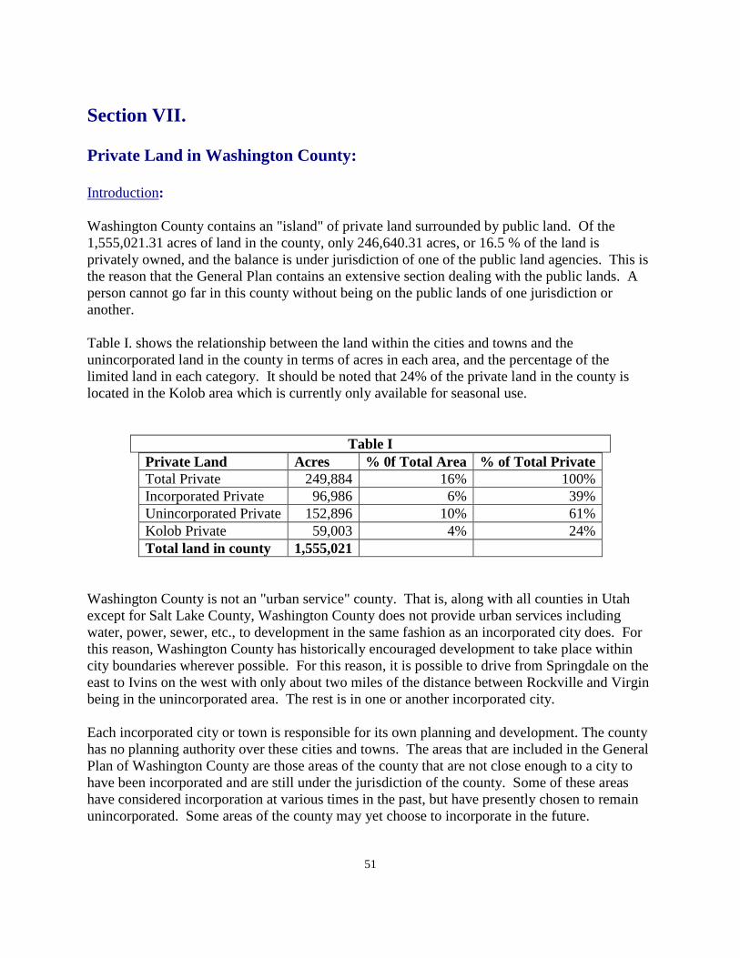
51
Section VII. Private Land in Washington County: Introduction: Washington County contains an "island" of private land surrounded by public land. Of the 1,555,021.31 acres of land in the county, only 246,640.31 acres, or 16.5 % of the land is privately owned, and the balance is under jurisdiction of one of the public land agencies. This is the reason that the General Plan contains an extensive section dealing with the public lands. A person cannot go far in this county without being on the public lands of one jurisdiction or another. Table I. shows the relationship between the land within the cities and towns and the unincorporated land in the county in terms of acres in each area, and the percentage of the limited land in each category. It should be noted that 24% of the private land in the county is located in the Kolob area which is currently only available for seasonal use.
Table I Private Land Acres % 0f Total Area % of Total Private Total Private 249,884 16% 100% Incorporated Private 96,986 6% 39% Unincorporated Private 152,896 10% 61% Kolob Private 59,003 4% 24% Total land in county 1,555,021
Washington County is not an "urban service" county. That is, along with all counties in Utah except for Salt Lake County, Washington County does not provide urban services including water, power, sewer, etc., to development in the same fashion as an incorporated city does. For this reason, Washington County has historically encouraged development to take place within city boundaries wherever possible. For this reason, it is possible to drive from Springdale on the east to Ivins on the west with only about two miles of the distance between Rockville and Virgin being in the unincorporated area. The rest is in one or another incorporated city. Each incorporated city or town is responsible for its own planning and development. The county has no planning authority over these cities and towns. The areas that are included in the General Plan of Washington County are those areas of the county that are not close enough to a city to have been incorporated and are still under the jurisdiction of the county. Some of these areas have considered incorporation at various times in the past, but have presently chosen to remain unincorporated. Some areas of the county may yet choose to incorporate in the future.
52
General Public Service Information: While Washington County itself does not provide public services to the unincorporated areas of the county, most of these areas do have access to public services. These services are generally provided by other public or private entities that provide services to the unincorporated areas of the county. Following is a list of the public services that are provided to all or part of the unincorporated areas of the county. They are listed by the service provided. Water Development: Historically, most developed areas in the unincorporated part of the county have been located where water was accessible. Where water was not available, some areas have been primarily used for grazing or dry farming. "Dry" subdivisions have not been approved in the county for the past 40 years. The saying went, "If you have water, you may develop. If you don't, you graze livestock." That saying relative to subdivision development is, if anything, more correct now than at any other time in the last forty years. Water development in subdivisions has historically taken one of two forms. In some cases the land developer has created a developer-owned water company to provide water for each lot in the subdivision. The other often-used option is for the developer to create a water company and to deed shares of ownership to the owners of each lot in the subdivision. This method is referred to as a mutual water company wherein the land owners also become the owners of the water company. The county, the State Department of Environmental Quality and the Southwest Utah Public Health Department have jointly set the minimum quantity of water required to be supplied for each lot, and require that developments meet state standards for water quality. Most of the currently developed culinary water in the unincorporated areas of the county comes from springs and wells. The highest quality of water in the county comes from the geologic formation called "Navajo Sandstone." This formation covers much of the central part of the county. There are a number of communities developed over the Navajo formation. This creates a potential for contamination of the ground water source. Once contaminated, it may take years or be impossible to remove the contamination. It would be much better to do whatever is necessary to prevent contamination in the first place. The General Plan recommends that wherever development exists or is proposed to take place above the Navajo Sandstone formation, all such developments be connected to one type of sewage disposal or another, as opposed to the continued use of septic tanks which are in use in most of the county. There are already some areas of the county where development is in place that has the potential for ground water contamination. The above methods of water development and protection have worked reasonably well, except for the problems of inadequate supply in dry years or inadequate storage capacity to insure
53
sufficient water in the subdivision. Sometimes a broken pump or pipeline leaves the water company or water provider without water in the subdivision until the problem is corrected. The General Plan visualizes a time in the future when all water companies in the county and those in the cities and towns will be connected together. When one area runs short of water, water could then come to the system from another source by turning on a valve. When the system is up and running again, the valve is closed and the system again relies on its own water. Some steps toward this end have already begun to take place. More is needed county-wide. The Washington County Water Conservancy District is a political subdivision of the State of Utah organized and existing under the Utah Water Conservancy District Act. The Water District was established in 1962 in response to a petition signed by the property owners of Washington County. The Water District is charged with conserving, developing, managing and stabilizing water supplies within the county. In accordance with state law, the seven members of the District's Board of Trustees are appointed to four-year staggered terms by the Washington County Commission. The openings are announced by legal notices and applicants are evaluated by the commissioners. The County has traditionally selected board members so that they represent all areas of the county. The Water District provides water to over 85% of the people of the County. Most of the people served with District water supplies are residents of Municipal customers of the District. During peak summer months, the Water District delivers over 34 million gallons a day to its customers. While the municipalities continue to manage their water delivery systems, they obtain additional water from the District as needed. The Water District is a “special purpose” district, in large part because the business of water is complicated. Particularly in the West, laws, rules, history, traditions and the complex facts of hydrologic cycles in desert river systems create layer upon layer of interacting factors. This specialty is one that many may know a little bit about, but few know a lot about. The Water District employs a manager to oversee its activities. The staff is hired and supervised in-house, not as county employees. The decisions that govern the amount, location and type of growth that generates the demand which the Water District must meet are delegated to elected officials of the municipalities and the county. The election process, the constitutional mechanism by which government obtains the “consent of the governed,” ensures that these officials are responsive to the desires of those who elect them. This way, there is a rational division of duties between an appointed board that carries special expertise necessary to address the complex issues involved with water delivery and the elected representatives of the people who make the decisions that determine the water demand. The Water District is funded in part through property taxes. These county-wide taxes are allocated to the Water District based upon the recognition of the broad public purposes for which water conservancy districts were created, in particular the control and conservation of water that benefits the community as a whole. Without water, there is no economy. Moreover, the economic benefits of water supply in the urbanized areas of the county are spread throughout the county. The broadly-distributed benefits provided by the Water District include managing the water supply of the Virgin Basin so as to maximize its availability to legitimate users, water
54
conservation programs that are necessary to ensure project approvals, watershed and water quality protection, water rights settlements that have avoided widespread conflict and addressing the demands of federal laws and regulations that would otherwise be imposed upon individual water systems such as the Endangered Species Act and the Clean Water Act. The Water District has responded to requests for help throughout the county from Enterprise to Rockville. The Water District seeks to provide the greatest service possible to those who pay taxes to the Water District, particularly where they are not receiving direct delivery of water from Water District projects, whether through consultation on water issues and projects or through grants and other partnerships. Payment of property taxes throughout the county distributes a portion of the costs to those who will receive services and benefits in the future, rather than forcing current users to fund programs designed to benefit future users. In addition, the Water District receives impact fees for water resources made available to its municipal customers under the Regional Water Supply Agreement (RWSA), first executed in 2006. The cities of Ivins, Santa Clara, St. George, Washington, Hurricane, LaVerkin, Toquerville and Leeds have all joined the RWSA. The town of Virgin is served by a separate contract and the Water District also has a contract with Apple Valley to provide certain services. Other income to the Water District is derived from charges for water delivered to retail and wholesale customers and from hydropower revenue. Communities may petition the Water District to obtain supplemental water supplies to serve additional demand. The Water District's response will depend on practical considerations such as whether there are additional water rights and developable resources that could be economically developed to serve anticipated demand. The arrangements are generally memorialized through contracts with water suppliers. The intent of the Water District is not to take over private or mutual water companies. Rather, it is in a position to provide supplementary water to these companies when needed and requested. Water District policy opposes takeovers of local water companies in any area of the county. However, the General Plan recognizes that sound public policy would support that water service to new development in the county be provided by the Water District. Since 1995, the Water District has strongly promoted water conservation throughout the county. In addition, the Water District has developed facilities necessary to supply the water to serve the population that has grown at an average rate of 6% since 1962. A number of important water projects were constructed and are maintained by the Water District. Today the Water District operates facilities from Kolob to Gunlock, including the Quail Creek Reservoir, Sand Hollow Reservoir, the Quail Creek Water Treatment Plant, a number of wells throughout the county, a number of transmission pipelines for culinary and for irrigation water and two hydropower plants and related infrastructure. Other projects are planned to be constructed in the near future to be able to continue efficient water resource management, including the Ash Creek Project that will involve construction of a new reservoir near Anderson Junction and the Warner Valley Reservoir Project. The General Plan is supportive of these efforts to provide for the water needs of county residents. The construction of reservoirs and wells at strategic locations in the county also helps to improve the underground water supply.
55
One project in which the Water District has been involved in planning for many years is the transfer of water from the state of Utah’s Colorado River water allocation to Washington County, through the Lake Powell Pipeline Project. The Project is a state project, pursuant to the Lake Powell Pipeline Development Act, passed in 2006. This state support is consistent with many projects in northern Utah that have brought water to the Wasatch front areas of the state that have been very successful. Under the Colorado River Compact, Utah’s allocation from the Colorado River is approximately 1.4 million acre feet (maf), with about 400 maf that has not yet been depleted by active diversions. There are limited opportunities to divert water from the Colorado River below the Uintah Basin so that currently, Utah’s undiverted water rights are flowing down river. The construction of the Lake Powell Pipeline will provide diversification of water supply to this county to ensure an adequate water supply in the face of recurrent droughts that may be exacerbated by climate change. The average annual flow into Lake Powell is about 12 maf, whereas the average annual flow of the Virgin River is about 130,000 af. However, for human use, you should only rely on the water that is there at least 90% of the time, which is about 4.5 maf in Lake Powell vs. about 77,000 af in the Virgin River. A supply of 69,000 acre feet from a total reliable supply of 4.5 maf acre feet (about 1.5%) will be more reliable than a supply of 39,000 acre feet from a total reliable supply of 77,000 af (about 50%). When the Virgin River is in drought, there will still be water available from the Colorado River in Lake Powell. The Lake Powell Pipeline will provide for the inevitable demands created by future growth and will help to ensure that the now existing communities in the county will not run out of water. The General Plan strongly supports the development of this additional water system. The Lake Powell Pipeline has been opposed by some groups in the county. They object to funding a project that could encumber future generations with repayment of the loan to construct the line. It is true that the people of Washington County will have to pay for the Lake Powell Pipeline Project, but that repayment is anticipated to take place over 50 or more years and should be funded almost entirely by new growth. On the other hand, if there is no additional water, water supplies will be less reliable, our children and grandchildren will not be able to build homes here and the economy will suffer. No one will have to pay for additional water because there will be no additional water once we have used up our existing supply. Isn't it possible that the opposition to the Lake Powell Pipeline is really opposition to any future growth and development in Washington County? Liquid Waste Disposal: There is only one sewage system presently in use in Washington County. This system is located in the Pinion Hills subdivision in Dammeron Valley. This system is in need of improvement to complete development of the Pinion Hills project. Currently the wastewater treatment method of necessity in most of the county is septic tanks. Some years ago the county prepared a plan, with the assistance of the State and other public agencies, to examine the ground water systems in the county to try to determined the holding capacity of existing basins where development has taken place. A table was prepared showing how many additional septic tanks could be approved in each area before the water table might be
56
compromised. Several areas are close to capacity, or could be over their capacity if a home was built on each subdivision lot that has been approved. This limits development in the county to large, single family lots which does not fit with the need for work force housing in the unincorporated area of the county. The primary work force housing type in the county is the use of modular housing units which the county will approve in all subdivisions. By working with the Department of Environmental Quality, the county was able to convince the State to explore alternative methods of waste disposal. The result of this effort was the approval of a number of "on site treatment plants" to process effluent as opposed to the use of septic tanks. This could allow a mixture of development types being able to process the effluent through one of the alternative methods now approved for developers to use. The county does not encourage sewer systems for new developments in the county, and in fact does not necessarily encourage developments in the unincorporated areas. However, where it is possible to provide the necessary facilities, the county does not oppose such development. In 2009, the county entered into agreements with the Ash Creek Special Service District and the Water District establishing responsibility to manage wastewater services throughout the county. Ash Creek SSD is responsible for the eastern part of the county essentially lying east of Interstate 15 freeway and in the New Harmony valley west of the freeway. The balance of the county (including the Kolob area east of the freeway) is the responsibility of the Water District. These agencies may authorize other alternative treatment systems to be used in addition to septic tanks as development continues in the unincorporated county. The Water District is currently working on a plan to provide a sewer outfall line from Dammeron Valley to connect to the St. George City Reuse Treatment Plant that may also serve areas in between over time. The General Plan of the county is in support of these service agreements for effluent disposal. Electrical Power: The majority of the unincorporated area of the county is served by the Rocky Mountain Power Company. Some areas of the county are served by the Dixie Escalante Rural Electric Company. Many of the incorporated cities have power companies owned by the city or town, and most of the companies are associated with the Utah Associated Municipal Power Service which is essentially a wholesale provider of electricity in many parts of the state. The General Plan of the county has attempted to identify all current and future utility corridors in the county. The power companies and the wholesale providers work well together to provide for current and future electrical needs in the county. Washington County does not provide electrical services to individual developments even though power is required by the county subdivision ordinance. The county does take responsibility to see that corridors are provided across the public lands to make sure that current and future needs will be provided for in the county. The county does show utility routes on the transportation plan of the county and reflects new routes that the county was aware of when that plan was prepared and adopted.
57
The Kolob area is the one area of the county where electrical service has not been provided up to this time. The General Plan would support any electrical company that would make an effort to bring power to this area. Rocky Mountain Power has recently expanded the capacity of the sub-station in the Central area of the county and is in the process of bringing an addition main line to this sub-station from the facility in Sigurd, Utah. The completion of this transmission line should be adequate to provide for the power needs in the county for many years to come. The Washington County Water Conservancy District expects to operate additional hydropower plants in conjunction with the Lake Powell Pipeline Project. Solid Waste: Historically, each community in the county maintained a "garbage dump" near their community. These "open dumps" were very unsanitary and the wind blew paper materials far and wide. The county was able to obtain land from the Bureau of Land Management which is located south-east of the City of Washington where a solid waste facility has been established to serve the entire county. All of the local facilities have been closed, and all solid waste is transported to the solid waste site. The county maintains a contract with a contractor to provide waste pickup throughout the county. The Solid Waste District is managed by a Board consisting of one member from each of the incorporated cities and towns, and one member from the county commission. There are satellite collection sites that have been established in parts of the county to save residents the need to drive to the landfill for small loads of refuse. Each city and town does their own billing for service, and the solid waste district bills for the unincorporated areas. Compared to the open dump facilities from past years, and with the reduction in refuse being dumped throughout the county in unauthorized locations, most of these sites have been cleaned up. One can only conclude that the system is working very well. The county is much cleaner, residents appear to be well educated as to how to use the system, and the management of the landfill is filling the need for which it was created. Roads: The county has spent a significant amount of time preparing a transportation plan for the county. This plan includes major arterial roads, collector roads, and special use roads. These plans do not show all of the county roads. For example, the plan does not include all roads within individual subdivisions, even though these roads have been dedicated to the county. Roads inside of the subdivision are included in the plan of class "B" roads which are the roads for which the county receives funding from state and federal sources for maintenance. The roads in the county are discussed in more detail in the public lands sections of the General Plan, particularly Section III dealing with the public lands under the public roads on BLM and National Forest lands. The General Plan refers readers to this section for more information as to
58
how these roads are maintained and how the maintenance is funded through the gasoline tax. The road system is very important to all county residents whether in the unincorporated or incorporated parts of the county. Most county roads, except for those in a recorded subdivision, are called county roads "by right of use." They were not dedicated by formal recorded documents, but the use by the public constitutes a public road dedication under state law. Many of these roads have been used for generations of time. These roads on federal public land were provided to the county by Congressional action in 1866. These roads are identified as R.S.2477 roads after the statute that created them. In recent years, environmental groups have challenged the right of the county to manage public access to these legally-dedicated roads. That right of use is supported by the General Plan at a significant cost of time and resources by the county. Police Protection: Police protection in the county is provided by the Washington County Sheriff's Office. The County Sheriff is the chief law enforcement officer in the county. In the past, some of the incorporated cities have contracted with the county to provide law enforcement services inside city limits. If a city or town does not have its own law enforcement agency, the county is required under state law to provide law enforcement to that city or town. In unincorporated areas, some of the developments, through their special service districts, or other organizations, have contracted with the county for "enhanced" police services to their area. Such contracts allow the county to bring additional law enforcement capability that otherwise would not exist due to limited resources. The general Plan supports this proposal. The county will continue to provide the services required by law. Fire Protection: Some years ago the county created fire districts to cover all parts of the unincorporated portion of Washington County. Table II shows each of the fire districts serving the unincorporated areas of the county, and the communities and areas that are covered by each district.
Table II Fire Districts and communities and Areas Covered by each District
Fire District Community / Area Covered Hurricane Valley Fire Anderson Junction
Cliff Dwellers/Sky Ranch/Hurricane Estates Harrisburg Junction Hurricane Valley Kolob area LaVerkin Toquerville
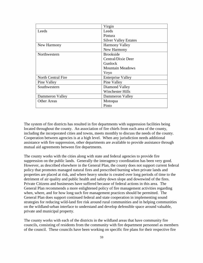
59
Virgin Leeds Leeds
Pintura Silver Valley Estates
New Harmony Harmony Valley New Harmony
Northwestern Brookside Central/Dixie Deer Gunlock Mountain Meadows Veyo
North Central Fire Enterprise Valley Pine Valley Pine Valley Southwestern Diamond Valley
Winchester Hills Dammeron Valley Dammeron Valley Other Areas Motoqua
Pinto The system of fire districts has resulted in fire departments with suppression facilities being located throughout the county. An association of fire chiefs from each area of the county, including the incorporated cities and towns, meets monthly to discuss the needs of the county. Cooperation between agencies is at a high level. When any jurisdiction needs additional assistance with fire suppression, other departments are available to provide assistance through mutual aid agreements between fire departments. The county works with the cities along with state and federal agencies to provide fire suppression on the public lands. Generally the interagency coordination has been very good. However, as described elsewhere in the General Plan, the county does not support current federal policy that promotes managed natural fires and prescribed burning when private lands and properties are placed at risk, and where heavy smoke is created over long periods of time to the detriment of air quality and public health and safety down slope and downwind of the fires. Private Citizens and businesses have suffered because of federal actions in this area. The General Plan recommends a more enlightened policy of fire management activities regarding when, where, and for how long such fire management practices should be permitted. The General Plan does support continued federal and state cooperation in implementing sound strategies for reducing wild-land fire risk around rural communities and in helping communities on the wildland-urban interface to understand and develop defensible space around valuable, private and municipal property. The county works with each of the districts in the wildland areas that have community fire councils, consisting of residents from the community with fire department personnel as members of the council. These councils have been working on specific fire plans for their respective fire
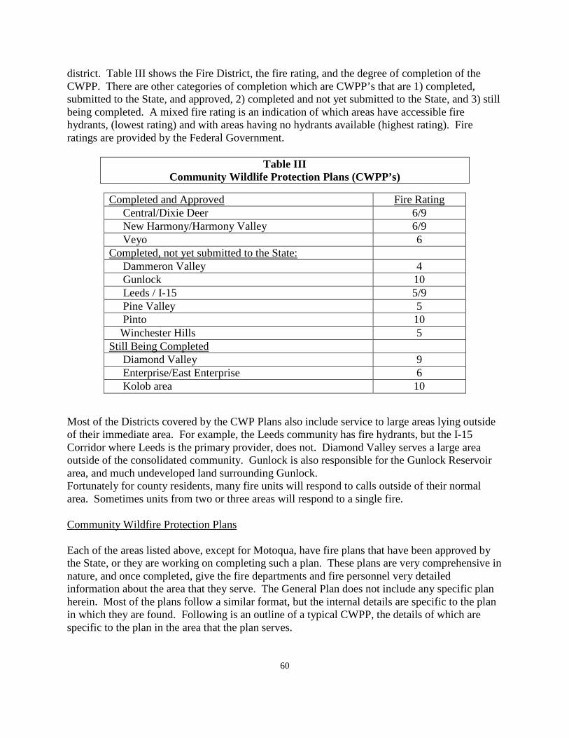
60
district. Table III shows the Fire District, the fire rating, and the degree of completion of the CWPP. There are other categories of completion which are CWPP’s that are 1) completed, submitted to the State, and approved, 2) completed and not yet submitted to the State, and 3) still being completed. A mixed fire rating is an indication of which areas have accessible fire hydrants, (lowest rating) and with areas having no hydrants available (highest rating). Fire ratings are provided by the Federal Government.
Table III Community Wildlife Protection Plans (CWPP’s)
Most of the Districts covered by the CWP Plans also include service to large areas lying outside of their immediate area. For example, the Leeds community has fire hydrants, but the I-15 Corridor where Leeds is the primary provider, does not. Diamond Valley serves a large area outside of the consolidated community. Gunlock is also responsible for the Gunlock Reservoir area, and much undeveloped land surrounding Gunlock. Fortunately for county residents, many fire units will respond to calls outside of their normal area. Sometimes units from two or three areas will respond to a single fire. Community Wildfire Protection Plans Each of the areas listed above, except for Motoqua, have fire plans that have been approved by the State, or they are working on completing such a plan. These plans are very comprehensive in nature, and once completed, give the fire departments and fire personnel very detailed information about the area that they serve. The General Plan does not include any specific plan herein. Most of the plans follow a similar format, but the internal details are specific to the plan in which they are found. Following is an outline of a typical CWPP, the details of which are specific to the plan in the area that the plan serves.
Completed and Approved Fire Rating Central/Dixie Deer 6/9 New Harmony/Harmony Valley 6/9 Veyo 6 Completed, not yet submitted to the State: Dammeron Valley 4 Gunlock 10 Leeds / I-15 5/9 Pine Valley 5 Pinto 10 Winchester Hills 5 Still Being Completed Diamond Valley 9 Enterprise/East Enterprise 6 Kolob area 10
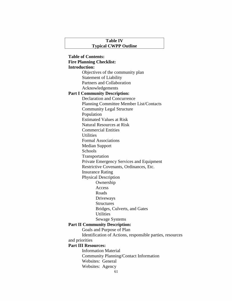
61
Table IV Typical CWPP Outline
Table of Contents:
Fire Planning Checklist: Introduction: Objectives of the community plan Statement of Liability Partners and Collaboration Acknowledgements Part I Community Description: Declaration and Concurrence Planning Committee Member List/Contacts Community Legal Structure Population Estimated Values at Risk Natural Resources at Risk Commercial Entities Utilities Formal Associations Median Support Schools Transportation Private Emergency Services and Equipment Restrictive Covenants, Ordinances, Etc. Insurance Rating Physical Description Ownership Access Roads Driveways Structures Bridges, Culverts, and Gates Utilities Sewage Systems Part II Community Description: Goals and Purpose of Plan Identification of Actions, responsible parties, resources and priorities Part III Resources: Information Material Community Planning/Contact Information Websites: General Websites: Agency
62
Websites: Fire Ecology, Education Websites: Utah Grants Contracting Opportunities Employment Opportunities Emergency Services/Equipment Projects Hazard Evaluation Area Fire Safety Subdivision Fire Safety Property Structure Rating Expected Fire Behavior Completed Fuel Modification Projects Community Prescription Fuel Modification Project Recommendations Infrastructure Improvement Project Recommendations Education Recommendations Wildfire Response/Pre-Attach Plan Monitoring and Evaluation Evacuation Plan Part V Appendix: There has been an extreme amount of work that has gone into the preparation and maintenance of each of these plans. The General Plan recommends that residents of any of these areas review the plan for your specific area and you will gain an appreciation for the time and effort that has gone into this project. The General Plan would further recommend that these plans be kept up to date and used in the training of fire personnel. The information that each of these plans contain is difficult to describe because of the extensive detail that each one contains. These plans provide great value to the residents of the county in terms of fire protection. Washington County is well served by the fire protection systems that are established and are in effect in this county. Telephone and Cell Phone Service: The major provider of telephone service in Washington County is the Century Link telephone system. Telephone service is available to most of the "occupied" area of Washington County. In recent years cell phones have become popular and almost a necessity for most people. There are cell phone towers in many of the cities and towns in the county as well as in the unincorporated areas. While there are still some "dead" spots in the county where service is not available, most of the areas where residents reside now have access to one kind of telephone service or another. The General Plan supports continued improvements to the telephone communication system in the county
63
Internet Service: Most residents of the county now use computer systems and other specialized forms of electronic devices for a variety of purposes, and the need for good internet services continues to grow. More recently, internet providers are working to provide what is referred to as "high speed" internet. Technology continues to improve and services continue to get better and less expensive. Service areas need to be expanded where possible. The residents of the county are the beneficiaries of these improvements without the county itself having any need to be directly involved in providing the service. The benefits in these areas that residents now enjoy are the result of private enterprise at work and represent one more reason that the county has avoided becoming an urban service provider. Schools: Washington County contains one of the largest school districts in the state. It is a county-wide district. The school district is completely separate from county government. There are five school board members elected from five geographical districts in the county. These district boundaries are required to be adjusted every ten years based upon the "one man, one vote" requirement. Generally speaking, four of the five board members represent the Ivins, Santa Clara, St. George, and Washington areas because of this being the center of the population in the county. One member essentially represents the balance of the county. Historically, the school district has been able to obtain public lands, mostly BLM land, as construction sites for new school buildings through the Recreation and Public Purposes act of the Federal Government in which the land is granted to the district on a lease basis and then is purchased by the district when the project is completed. Because there are much fewer scattered BLM parcels available for selection by the district at this point in time, the school district will find it necessary in the future to acquire sites from other sources. Washington County collects property taxes for the school district as well as for all of the cities and towns, special service districts, the Water District, and all other taxing districts in the county. Those taxes are distributed to the various taxing entities by the county, but the county is not responsible for the tax levies set by these taxing authorities. In fact, the General Fund property tax of Washington County is the lowest of all of the twenty-nine counties in the State. Parks and Recreation: Because of the decision of the county not to get involved in providing urban services to subdivision developments in the county, the county does not have a parks and recreation department as do most of the cities and towns. The county has generally found that with all of the unincorporated vacant land in the county, sufficient recreation benefits exist for the residents without the county being involved in urban-type recreation programs. Some years ago the county did acquire land in what is historically known as the "Purgatory" area. The area was named because the land was so poor that the early settlers couldn't grow anything on the land, nor did it provide sufficient feed for livestock. The county was able to
64
acquire buildings, stables, arenas, bleachers, race track fencing, and other recreational amenities and located them on this site. The cost to the county was less than half of what new materials would cost. The official name for the site is the Washington County Regional Park and Equestrian Center. It supports many different uses and receives funding for its upkeep and maintenance from the county restaurant tax. The county acquired the property from the BLM at a very low rate, about $400.00 per acre, and recently acquired an additional 80 acres through the Washington County Land Bill to be used for future expansion of the correctional facility. Adjacent to the Regional Park is another parcel of property obtained from the BLM under an R& PP lease as was the Regional Park and the Correctional Facility. It has been developed as a regional sports shooting park for rifle, handgun, shotgun and bow and arrow. The management and development of this facility is moving along well, and when it is completed, this site may also be purchased by the county. These two facilities represent the county's total involvement in recreation development. There are no plans on the part of the county to expand into other areas or other types of recreation. Flood Plains and River Bottoms: Washington County has developed and adopted a flood control ordinance for the county. This ordinance prohibits any urban development in identified flood channels or washes. Working with the federal agency, the county has been able to update most of the flood control maps for the county which identifies flood plains, floodways, and washes where floods may be a problem. All development is weighed against the flood control ordinance prior to the approval of any new development. The Water District, along with other local agencies, has sponsored master plans for the Virgin and Santa Clara rivers. The General Plan recommends that flood prone areas be retained in an open space classification to protect them from the effects of urbanization and to prevent needless flooding impacts on developed property. Air Travel: There are several airports located in the county. Some are privately owned, and a few are publicly owned facilities. St. George City completed the construction of a new municipal airport in in the south-east part of the city. This facility has allowed the current airport, located in the center part of town to be eliminated, and to allow compatible urban uses to take place over time on the ground. The new airport provides longer runways which allows for larger planes to land and take off. The airport is expected to encourage more commercial, business or industrial development that depends upon air travel and services. The General Plan supports the efforts of the City of St. George to construct the airport and the supporting facilities surrounding it for the benefits it will bring to the county, but even more important, for the additional safety that it will bring to those
65
coming to and from the area. Many dangers existed at the old airport that has been eliminated with the new facility. Agricultural Development: Agriculture has long played an important role in the custom, culture, and economy of the county. Its future maintenance and development is supported by the General Plan. Agricultural land is identified as areas where land is being used for irrigated pasture land, and for the growing of crops or orchards, either irrigated or dry. While equally important, this classification does not specifically designate the large areas of the county where livestock grazing takes place. The agricultural land in the county has been reduced over the years as urban development has expanded into agricultural areas. One example of this is the Washington Field area. This area was one of the most fertile agricultural areas in the state of Utah. Earlier plans called for development in the Washington area to take place north of the I-15 freeway in the large basin in that area. The adoption of the Habitat Conservation Plan for the protection of the Tortoise changed that plan by eliminating development in the HCP area. This caused land in the field area south of Washington to be annexed into the city for urban development. It can no longer be considered or protected as an agricultural area. There are still some agricultural lands in the Enterprise and New Harmony areas, and some dry agricultural land in the Smith Mesa area. The General Plan would recommend maintenance of these areas as agricultural land as long as possible. There are other small islands of agricultural land in the county, but there are no other large areas of available land still available. There is however, a significant amount of public, state, and private land along the originally proposed Southern Corridor along the Arizona border between the Hurricane Cliffs and the Town of Apple Valley that could support agricultural development. Residential Development: There are, in Washington County, at least thirteen identifiable unincorporated communities. The policy of the county for many years has been to encourage, or require, development adjacent to existing cities and towns to promote annexation into those already incorporated areas where urban services are available. The purpose of a city or town is to provide services that cannot be developed on an individual basis. The position of the county is to not compete with these cities and towns. Some of the thirteen unincorporated communities may well become incorporated at some point of time in the future. The policy behind the county encouraging development to take place in the incorporated communities is one that says that government closest to the people is the best form of government. Many of these unincorporated communities are approaching the point where services need to be provided that may best be provided through incorporation. There are unincorporated communities in the county that have developed in places where water has been developed. Some of these communities may simply be a single subdivision, while others have land around them that would allow for further development.
66
Historically, unincorporated land has developed on large single home lots. In the future this development pattern could change in response to water and wastewater requirements. One reason that the county entered into the Vision Dixie project was to establish conditions that should be considered when new development is proposed at some place in the county. A summary of these recommendations is found in the 2009 Resource Management Plan which is included as a part of this General Plan. Each of the existing unincorporated community plans has included a review of the Vision Dixie principles as a part of the General Plan for each specific community. Many of these principles will be easier to implement in new development rather than in development that was started many years ago. Residential growth should be made in a natural pattern through extension of existing residential areas so as to minimize the tax burden related to providing schools, libraries, parks, highways, police and fire protection, sewage and garbage collection and other facilities and services necessary for the enjoyment of a community Developments should be considered in terms of economic feasibility to the county, not only as to marketability of land, but in the time needed for development to take place, and whether this development will be an asset to the county or a detriment to the county in terms of the cost of providing and maintaining the goods and services needed by the residents of the county. Growth is associated with responsibility, and bigness does not always mean goodness. Efforts should be made toward encouraging quality development rather than quantity development. The General Plan seeks for high quality development instead of "boom to bust" growth. Affordable Housing:
Utah Code Annotated, 1953, as amended, requires each county of the State of Utah to adopt a plan for moderate income housing. After adoption of the plan, the county legislative body with a population of over 25,000 is required to prepare a biennial review and report of its findings.
Washington County has a history of growth. In fact, the growth of the County has nearly doubled every ten years since 1960. The 1990 census showed a population in Washington County of 49,139 residents. The year 2000 census shows a County population of 90,354 residents, with the 2010 census showing 138,115 residents.
The majority of growth in the County takes place in the various incorporated Cities and Towns of which there are thirteen incorporated places in Washington County. Washington County is not an urban service County. That is, the County does not provide urban services to residents of the unincorporated area. Whenever a development is proposed adjacent to, or nearby, any of the Cities or Towns in the County, the County first requires that an effort be made to annex the property to the respective City or Town.
While County population has increased rather dramatically in the past several decades, the population of the unincorporated area does not reflect that same level of growth. This is primarily because of the annexation of areas as they are proposed for development. Areas such as Bloomington, Bloomington Hills, Green Valley, Dixie Downs, Entrada, Sunbrook, Middleton,
67
Harrisburg, Hurricane Fields, West and South Hurricane, Washington Fields, Kayenta, Apple Valley, etc., all had their beginning in the unincorporated area, and are now part of one City or another except for Apple Valley which is a completely newly incorporated Town. The 2010 census shows a population in the unincorporated county area of about 7,606, which is a very little change from 2000.
Moderate Income Housing Element and its implementation
The key policy of the county’s general plan is for all types of housing to be directed into the incorporated municipalities that can provide adequate governmental infrastructure, public health, emergency services and private community services. This policy is based on the premise that a valid evaluation of housing quality if not solely a look at the structure itself, but also includes a look at the adequacy of supportive services available to householders. This key policy is still in effect.
Notwithstanding the above policy, the unincorporated area has its certain economic pursuits, such as agriculture, transportation, industry, and mining; each requiring housing to serve those involved. It continues to be a policy of the county to have a fair share of its housing to be considered affordable housing.
Presently in the unincorporated area of Washington County there are 86 subdivisions that have been developed and recorded. Included in these subdivisions are a total of 4615 building lots and currently there are 2,701 homes existing in these subdivisions. There are 1,914 vacant lots in those existing subdivisions.
Efforts made by Washington County to reduce, mitigate, or eliminate local regulatory barriers to Moderate Income Housing
Toward Lower Cost Development. Washington County continues with the following programs which tend to encourage the development of new moderate income housing units:
1. Policy of having no impact fees. The only impact fee in Washington County is a fee of .002% that is charged against a building permit valuation to pay for the Habitat Conservation Plan, which allows development to continue in the County. On a $100,000 home is amount would add $200.00 to the cost of a permit. For modular dwellings, this fee is approximately 50% of what it would be for a conventional type dwelling.
2. Because the requirement of inspections is less for modular dwelling than for conventional dwellings, the permit fee for modular dwellings is also calculated at approximately 50% of the fee for conventional dwellings.
3. The County intends to continue to allow modular units to be constructed in all residential zones in the County. The County makes no differentiation between modular housing and “stick built” housing. Modular units must be permanently installed just as conventional
68
construction is required. From the County standpoint, all are residential housing units, and all are treated equal.
4. A number of the residential zones allow for a second dwelling to be constructed on the same lot as the primary dwelling unit. The Open Space Zone, Agricultural Zone, and the Residential Agriculture 5 and 10 acre zones all allow a second dwelling for a member of the owner’s family, or an employee of the owner. Based upon the present zoning of current subdivisions, 2742 acres of land in subdivision development and 486 existing lots allow for a second dwelling. Also, farm labor housing is allowed within these same zones. The pre-eminence of agriculture as a land use in the unincorporated are of Washington County is acknowledged, it identifies a need for unincorporated county farm labor housing. This need is for both those farm laborers hired to work year round and those who are hired on a seasonal basis during periods of harvest. The Washington County Land Use Ordinance allows for such housing, requiring the farm owner to be the provider.
5. Most of the zones now allow for the construction of a second kitchen in the home as long as it is part of the dwelling and not constructed strictly as an apartment. This allows for the typical “mother-in-law” unit that is becoming more and more necessary with an aging population.
6. The County requires 10 days from the time a building permit is requested until it is processed. Most generally however, the turn around time is seventy-two hours or less unless there are specific problems with the site that need to be addressed.
7. When building inspections are called for, we require twenty-four hours notice. Most usually, if the request is received prior to 5:00 p.m. on a given day, the inspection will be made the next morning or afternoon at the latest.
8. The County will continue to look for ways and means to make housing affordable in unincorporated County areas.
Progress made within the County to provide Moderate Income Housing, as measured by permits issued for new units of Moderate Income Housing The need for moderate income housing in the unincorporated area of Washington County in the initial Plan for Moderate income Housing (as adopted 1999) was calculated from the 1990 Census and the current information was calculated from the 2000 Census and the 2010 census, The calculations are as follows:
Year Population 2000 5,858
69
2006 9,426 estimate
2010 7,604 actual
2020 12,154
The unincorporated area of Washington County accounts for less than 6.5 % of the total County population. Based upon the percent of County population living in the County unincorporated area, there are already sufficient housing alternatives available to take care of the need for low and moderate income families in the County. In reality, because of continued annexation of areas as they develop, the percent of residents in the County living outside of a City or Town boundary will likely decrease as a percentage of total County population. Much of the over estimated population from 2006 can be accounted for in the incorporation of Apple Valley prior 2006.
The median area income for Washington County in 2005 was $45,900, according to Department of Housing and Urban Development (“HUD”). Moderate income households consist of those households who earn 80% or less than the mean area income. This means that any household earnings $38,700 or less in 2005 would classify in the moderate income category. In 2009, the Governor’s Office of Planning and Budget shows the median household income as being $58,820. The figures below show the number of permits that were issued for dwellings and the number of dwellings that were below the moderate income level, including the price of the lot, according to Washington County Department of Building Safety Development records.
Year Building Permits Issued Housing < $120,912
(Single Family & Manufactured)
2005 174 7
2006 96 5
2007 74 5
2008 42 10
2009 23 2
2010 25 6
2011 20 1
Unincorporated Washington County has maintained a high percentage of moderate income housing for new single-family structures, due mainly to the zoning that allows manufactured homes as an alternative to site-built structures in any location where zoning compliance for a single family dwelling can be approved.
Washington County is interested in providing affordable housing for its residents. Wages and salaries in Washington County are below the average for the State of Utah and for the nation as a whole. They have been this way for generations. Part of the reason for this is because of a service oriented economy in the County. Another viable reason is because of the higher than average number of retired persons living in the County who generally have sold a home

70
somewhere else, paid for a home in Washington County and live comfortable on a smaller, fixed income.
Actions taken by Washington County to encourage the preservation of existing Moderate Income Housing and the development of new Moderate Income Housing.
Preservation. Typical housing economies are such that those with higher incomes are the ones who construct new homes; those with modest incomes “move up” to the units vacated by those who have built the new homes; and those with still lower incomes move up to the homes vacated by the second-tier income individuals. However, new units are seldom available to lower-income households without the availability of government subsidies.
The County is trying to encourage development of high density housing or clustering, and in 2008 agreements have been entered into with the Ash Creek Special Service District to be responsible to monitor and provide liquid water oversight to development in the eastern part of the county essentially lying east of Interstate 15 freeway and in the New Harmony valley west of the freeway. The balance of the county will be monitored by the Washington Conservancy District along with the Kolob area east of the freeway. This agreement opens the door for other systems to be used in addition to septic tanks as development continues in the unincorporated areas. The General Plan of the county is in support of these service agreements for effluent disposal. There are a number of other techniques that can be used by the county to continue to provide housing or low and moderate income families.
The County presently offers a number of incentives to providing low and moderate income housing that might not be found in all Cities and Towns. Particularly in the area of impact fees, the County is far less than its incorporated neighbors. Except for a mandated fee for the Habitat Conservation Plan, there are no other impact fees in the County. The County will continue to explore ways and means to allow low and moderate income housing to take place in the County. In addition to many of the things mentioned in this report is an ongoing effort to allow sewer systems to be extended into unincorporated areas, thereby making provision for multiple family or higher density single family residential development to take place.
The Five County Association of Governments (“FCAOG”) and the new regional Metropolitan Planning Organization (“MPO”) provide access to valuable Federal and regional housing assistance programs, block grants, residential rehabilitation loans, and down-payment/closing cost assistance programs, among other programs and assistance. Washington County should encourage the use of services provided by these organizations in furthering housing needs and goals to serve the public. Annexation: The county policy on annexation is found previously in this plan. The county does not oppose annexation to existing cities and towns. When communities are located away from existing cities and towns and it is not convenient to annex, consideration should seriously be given to incorporation rather than to continue expansion of unincorporated areas.
71
New Development Areas Identified: There are a number of areas in the county that have been identified for development from time to time. Since there has been a downturn in the economy, areas that were being considered for development just a few years ago, are now lying dormant. Assuming that the economy improves in coming years, some of these areas may again be proposed for development. Among the areas where development has been proposed include land on Smith Mesa, the Dalton Wash area, the Harmony Valley, significant future development in the Dammeron Valley area, and more development in the Enterprise area of the county. In addition to these areas where development has been proposed, the Land Bill identified several tracts of land equaling some 4,000 acres of BLM land that are expected to be sold for private development. These parcels were identified in the BLM Resource management Plan. One large area of some 1,300 acres is proposed for sale in the city of Santa Clara, south of the Santa Clara River, and identified as the 'South Hills" area. Some of that land contains threatened and endangered plants which would reduce the available land. Another area of significant size is in the area lying between Dammeron Valley and Gunlock which could be released for sale in the future. The Land Bill did not designate any time frame for the disposal of the BLM property, so it is unlikely that any of it will be sold while the general economy is moving a much slower rate than it was a few years ago. Housing: Presently in the unincorporated area of Washington County there are many subdivisions that have been developed and recorded. Included in these subdivisions are a total of 4615 building lots available for residential construction. Currently there are 2701 homes existing in these subdivisions. There are still some 1914 vacant lots in the unincorporated part of the county that could be built on. 41 percent of the lots in the unincorporated county are still vacant and available for construction. These figures are approximate and do not include scattered parcels around the county.
Table V
Housing in Washington County Number of developments studied
13
Number of building lots 4615 Number of existing dwellings 2701 Number of vacant lots 1914
Because the historic method of liquid waste disposal has been through the use of septic tanks, the size of lots in the county has been upwards of 1 acre in size. Because of the value of land, it becomes difficult to construct low and moderate income housing on these large lots, with the exception of modular units. Therefore, modular units account for most of the current low and
72
moderate income housing in Washington County. Two things could change that situation. Through the Water District, water may become available in parts of the county where it has previously been unavailable. In addition, it is now possible to construct an on-site treatment plant for sewage disposal which would then allow for a variety of housing types similar to those currently available in the various cities in the county. The on-site plants are too expensive for a single dwelling unit, but in a larger planned development containing a variety of housing types, they become much more affordable. Commercial Development: The General Plan considers the commercial needs of the various parts of the county. Basically, commercial development is divided into two categories, the shopping center and the highway service center. Shopping centers may be further reduced to provide basic convenience goods to smaller areas. Highway service centers are for the purpose of serving the traveling public. Shopping centers should be planned, designed and located as a part of existing community development. Many of the communities do not have any commercial development or else there is very limited commercial activity. This lack of existing services provides the opportunity to develop quality shopping facilities, determine where they should be located and where types of commercial development can locate in proximity to other businesses. Even in many of the existing communities, commercial sites could be identified using Vision Dixie principles which would, in the future, provide commercial services to the residents of the area. The delivery of commercial business is largely dependent upon economics in deciding whether or not to locate in a particular area. However, in community planning, provision should be made for logical commercial space to be incorporated into the community. Time will take care of actual development. When it does come, it will be an integral part of the community where residents can walk to shopping facilities without the use of an automobile. This is the pattern that the General Plan recommends to be followed in new communities, and where possible to be identified in existing communities during the planning process. The General Plan recommends against the development of communities with a "strip" of commercial land running the length of the community. This type of development will encourage marginal commercial development and speculative commercial activities, most of which will usually be unsuccessful. This type of commercial development is not generally useful to small rural comities and is better left to larger city development. The General Plan does not attempt to limit commercial competition, but rather to direct it to areas where it can develop harmoniously into the plan for the total community. The General Plan proposes relationships where growth, progress, and service can be achieved without adversely affecting other segments of community life.
73
Industrial Development: Industrial development continues to increase in Washington County. Some areas of the county seek industrial development, others do not. Very little industrial development exists in the unincorporated areas outside of some limited mineral development, particularly sand and gravel operations. Industrial development normally requires a close proximity to areas where public facilities are available. Many such developments are dependent upon access to the I-15 Freeway and should not be located in areas where freeway access is not readily available. Washington County has never sought the establishment of pollutant type industries. Strict controls and regulations should be imposed on any industry located anywhere in the county to guarantee against pollution of air, land, or water supplies. Community Plans: This section of the General Plan contains the community plans for most of the unincorporated communities in the county. Previous planning has been done in some of these communities; some have never had a community plan prepared. Plans may be developed in areas not currently listed. Those areas that have been developed and are found in this section of the General Plan include the unincorporated areas of Brookside/Pine Valley Mt. Farms, Central/Dixie Deer Estates, Cliff Dwellers/Sky Ranch/Hurricane Cliff Estates, Dammeron Valley, Diamond Valley, East Enterprise, Gunlock, the Kolob area, Harmony Valley, Pine Valley, Pintura/I-15 Corridor, Veyo, and Winchester Hills. Plans for each of these areas have been developed individually community by community, and have been added to this section of the General Plan of the county as follows:
74
THE BROOKSIDE / PINE MOUNTAIN VALLEY FARMS COMMUNITY
GENERAL PLAN 2010 - 2011
Introduction: The Brookside/Pine Valley Mountain Farms community is a part of the unincorporated part of Washington County. It is one of about twelve unincorporated communities in the county. Residents of this community, and others, should take time to review Section I of the County General Plan which discusses planning in general, the basis for planning, and the purpose of planning. Many of the things mentioned in the beginning of Section VII are also relevant to the residents of this part of the county. The General Plan provides guidelines for the future of this particular part of the county in addition to those things that are applied county-wide in the other sections of the General Plan. The Brookside / Pine Valley Mountain Farms community is interesting inasmuch as the original development in Brookside took place prior to the county having any type of planning ordinances such as subdivision or detailed zoning regulations. On the other hand, the Pine Valley Mountain Farms subdivision development is among the more recent subdivisions in the unincorporated area of the county. Access to the Brookside area is through the Pine Valley Mountain Farms subdivision. Roads are paved in Pine Valley Mountain Farms and are dedicated county roads, while the roads in Brookside are unimproved and undedicated. While these areas are technically two separate developments, they are generally referred to as the Brookside development. The first plat in Brookside was recorded on June 16, 1965, with two or three phases being added later. The Pine Valley Mountain Farms subdivision plat was recorded on April 19, 1976, with a smaller phase added at a later date. All of the Brookside subdivision plats contain a total of 108 recorded lots, and the Pine Valley Mountain Farms plats contain 43 lot. There is some land north of the Farms subdivision containing a farm house and one other home along with land acreage which combines with the subdivision areas to make up the community. Geography and Topography: Pine Valley Mountain Farms was developed alongside State Highway 18 between St. George and Enterprise in Washington County. The subdivision was located just a few miles north of the community of Veyo which is also unincorporated. The Brookside development originated at a lower elevation than its companion subdivision, and was platted in lots on both sides of the Santa Clara River. Because many of these lots back up to the river, the subsequent home development, in most cases, took place at the back of the lots with the homes being constructed immediately adjacent to the river. The location of these homes are in a beautiful location and have especially been desirable to part time home owners who have developed their property as seasonal homes for seasonal use as opposed to the year-around residents who live there. County records would indicate that about 45
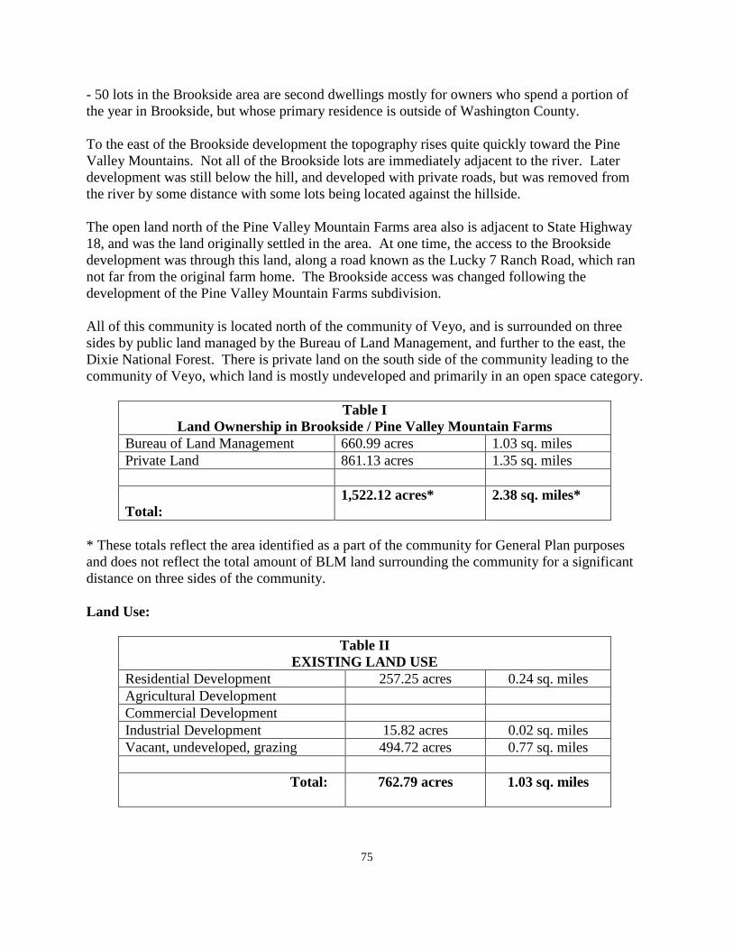
75
- 50 lots in the Brookside area are second dwellings mostly for owners who spend a portion of the year in Brookside, but whose primary residence is outside of Washington County. To the east of the Brookside development the topography rises quite quickly toward the Pine Valley Mountains. Not all of the Brookside lots are immediately adjacent to the river. Later development was still below the hill, and developed with private roads, but was removed from the river by some distance with some lots being located against the hillside. The open land north of the Pine Valley Mountain Farms area also is adjacent to State Highway 18, and was the land originally settled in the area. At one time, the access to the Brookside development was through this land, along a road known as the Lucky 7 Ranch Road, which ran not far from the original farm home. The Brookside access was changed following the development of the Pine Valley Mountain Farms subdivision. All of this community is located north of the community of Veyo, and is surrounded on three sides by public land managed by the Bureau of Land Management, and further to the east, the Dixie National Forest. There is private land on the south side of the community leading to the community of Veyo, which land is mostly undeveloped and primarily in an open space category.
Table I Land Ownership in Brookside / Pine Valley Mountain Farms
Bureau of Land Management 660.99 acres 1.03 sq. miles Private Land 861.13 acres 1.35 sq. miles Total:
1,522.12 acres* 2.38 sq. miles*
* These totals reflect the area identified as a part of the community for General Plan purposes and does not reflect the total amount of BLM land surrounding the community for a significant distance on three sides of the community. Land Use:
Table II EXISTING LAND USE
Residential Development 257.25 acres 0.24 sq. miles Agricultural Development Commercial Development
Industrial Development 15.82 acres 0.02 sq. miles Vacant, undeveloped, grazing 494.72 acres 0.77 sq. miles
Total:
762.79 acres 1.03 sq. miles
76
The above figures are does not survey accurate, but they do paint a relative picture as to the relationship between the various types of land use. Open Space: There is a significant amount of open space in the area surrounding the Brookside/Pine Valley Mountain Farms development. It is managed by the BLM, and the present open space use of land is not likely to change in the foreseeable future. The only current use is the small area used as a cinder pit lying to the west of the community. The part of the pit currently being used could be expanded, but the overall size of the cinder pit is what it is. It is not likely to get any larger. There is a large parcel of private land lying toward the northern end of the community that is also mostly open space and land used for livestock grazing. There are currently two dwellings in this area. Agricultural use is not likely to expand beyond small areas currently being used. However, if services, particularly water, were available in large quantity, the area could be developed residentially similar to the other developments in the community. Agricultural Land: Other than individual home gardens, there is virtually no agricultural development in this community. The actual amount would be too small to calculate as a percentage of the total land area. There is not a lot of land area where agricultural pursuits could be pursued. Residential Development: The only type of residential development in the community is single family dwellings. This is the type of development that has been planned and carried out since the area was started. The soil condition in Pine Valley Mountain Farms does not lend itself to farming with a rather shallow layer of soil to absorb septic tank effluent. In the case of the Brookside development, the dwellings are generally located close to the Santa Clara River which may cause septic tank problems by the proximity of the dwellings to the water course. In order to support other types of residential development, i.e. townhomes, condominiums, apartments, etc., it would require an on-site treatment plant of some kind to take over the liquid waste requirements. This is not likely to happen any time soon. The General Plan discusses this situation further in the service section of this Plan. There are a total of 43 lots in the Pine Valley Mountain Farms subdivision. There are still approximately 10 vacant lots in this development. The Pine Valley Mountain Farms development has essentially reached "build out." In the Brookside Development there are some 108 platted lots along with some lots sold by metes and bounds and not platted. In the Brookside section of the community there are approximately 50 lots that are vacant and available for building.
77
With about 60 vacant lots in the entire community, the entire area is not far from "build -out." The actual number of building permits issued for dwelling units over the past ten years is shown Table III as follows:
Table III Residential Permits Issued 2001 - 2010
Year PVM Farms Brookside 2001 0 1 2002 0 3 2003 0 1 2004 0 0 2005 1 2 2006 0 1 2007 2 2 2008 1 0 2009 1 0 2010 0 2
Totals: 5 12 combined = 17
Over the past ten years there has been an average of almost 2 permits issued each year. With some 150 lots in the community and about 60 of them being vacant, and an average of 2 building permits being issued each year, the community could support further development of permits per year for another 30 years before reaching complete build-out. This projection does not anticipate a great amount of future growth to take place. Current Population and Population Density: As a part of the unincorporated area of the county, specific population figures for each of the individual unincorporated communities are not available. The total population for Washington County unincorporated, based upon the recent census information, was 7,606 residents, or a community about the size of the City of Ivins. The average family size in the county is in the range of 2.8 to 3.2 residents per dwelling unit. This is a little less than the average family size found in the statistical information gathered for this community. However, using an average of the county figures and estimating about 3.0 residents per family, it can be estimated that the General Plan would project the current community population to be in the range of 270 residents. This would constitute a community between the size of the Town of Rockville, and the Town of Springdale. .
78
Future Growth and Development: Projecting population over the next ten years is best done by using the average number of permits for the past ten years combined with possible future growth. Building permits could be expected to increase incrementally over a period of time. The desire for single family homes will likely continue even though the Vision Dixie Plan calls for a mixed use type of development with higher density interspersed with single family and commercial development. How quickly the economy rebounds will determine how quickly additional homes will be built in the community. Using a projected annual growth similar to the average number of building permits of the 2001 to 2010 period, the General Plan would project an increase of 60 residents over the next ten years. This would make for a population growth in 10 years of about 300 more residents. The General Plan also calls to the attention of the residents of the area; Brookside is home to a number, about 50, homes as second dwellings. This could reduce the permanent population over the next ten years to even less than 300 permanent residents. Vision Dixie Principle Summary: Along with recommendations for residential growth and future development in the valley, along with other types of development such as commercial growth, the Vision Dixie Project, which was sponsored by Washington County a few years ago, and which was adopted by the county upon completion, makes recommendations for many other phases of community development. A summary of the Vision Dixie Principles and their relationship to this area is shown as follows: 1. Plan regionally; implement locally - The General Plan for this community is a local plan
for the residents of this area. It is also intended to be adopted as a part of the Washington County General Plan.
2. Maintain air and water quality, and conserve water - Air and water quality is very
important to the residents of this combined community. Most of the people, who live in communities such as this area, are there because of the clean air that exists. Conservation is also evident because of the limited outdoor watering on individual lots and the amount of natural landscaping that exists. There are trees in the area to provide summer shade, but much landscaping is of a natural variety that does not require additional water.
3. Guard our signature landscapes - See the section of the plan dealing with open space
development. Most of the land surrounding the community is under the direction of the BLM, with the mountains to the east controlled by the Forest Service. There are no plans for development on any of this land. The areas surrounding this community should protect the view shed of this area with the possible exception of views to the south which contain a considerable amount of private land which could generate development.
4. Provide connected natural recreation areas and open spaces - There is no shortage of
natural open space recreation areas surrounding Pine Valley Mountain Farms/Brookside.
79
This area is available for open space recreation activities. There is no significant desire on the part of residents to develop additional recreation facilities within the community, but there are natural and developed recreation areas within a close distance to this area already existing.
5. Build a balanced transportation system - The county has developed a county-wide
transportation plan. See Section III of the General Plan for further information the county transportation plan. As far as such things as a commuter bus system connecting St. George City and Enterprise, that service is still many years in the future, but could become a reality at some future time with stops along the way in the various communities between the two cities.
6. Get centered by focusing on growth in walkable mixed use centers - In a community such
as this one, that was developed prior to the Vision Dixie Plan being developed, it is difficult to retrofit the community into a mixed use center now that it has been almost fully completed. The community is compact enough that it could be considered to be generally walkable as it is currently developed. Residents responding to the county questionnaire were not in favor of developing any system of walking or bicycle trails, as such. But those things are available in the community as it is currently developed without any special consideration to those services.
It is not a mixed use community in the true sense of mixed use, although the two aspects of the community do provide a variety of living experiences, either on the bench adjacent to Highway 18, or in the Santa Clara River valley below the rim. It would be difficult at this time to identify areas for a true mixed use of residences to be developed. Unless a sewage system was installed for the entire community, it would be difficult to develop lots of a mixed use nature using septic tanks as the means of waste disposal even if there was still an undeveloped part of the community where it could be done. To develop mixed use in the open space area north of Pine Valley Mountain Farms would require a system of waste disposal as well as a source of culinary water. It could happen, but is not likely in the near future.
The future of commercial development as a part of a mixed use center is discussed in a future section concerned with commercial development.
7. Direct Growth Inward - The area has developed with relative compact growth. This
community, as well as all other unincorporated communities, has not been able to support a higher mixed use density using septic tanks. On-site treatment systems have not been available for use in Utah until recent years. There are currently no such facilities in use in the county except for a large common septic tank system in the Pinion Hills area of Dammeron Valley.
8. Provide a broad range of housing types - This element has been discussed previously.
As far as the unincorporated communities of the county are concerned, the variety of housing types is definitely limited. As far as housing types are concerned, the county approves conventionally built homes and modular homes. There are probably more
80
modular homes in the county than in any of the cities and towns. However, all of these types of dwellings are of a single family residential nature. The limitations to mixed use housing are discussed above.
9. Reserve areas for industry - The residents of this area have strongly indicated that they
are not in favor of industrial development. One industrial development does exist to the west of the community in the form of a cinder pit leased by the Bureau of Land Management as a community pit with a portion leased for commercial use to a business in the St. George area. Such things as a cinder pit or gravel pit are located where they are, but to locate various types of industrial business in this area is not feasible because of the distance to freeway travel and to the markets that are associated with long distance transportation. Any additional industrial use of land in this community is not proposed by the General Plan and is not likely to happen.
10. Public land conversion - No conversion of public land is needed for the build-out or
additional growth of this community. The only potential for future development in the valley which would include more land being added to the existing development lies to the north and south of the current development, all of which are already on private land. While the acquisition of some public land for future use might be possible, it does not appear to be a feasible, or needed, alternative in the case of Brookside or Pine Valley Mountain Farms. .
Commercial Development: Commercial development is mostly non-existent in this community. Those responding to the county questionnaire were nearly unanimous is their recommendation against any significant commercial business in the area. In terms of the Vision Dixie Project, the recommendation relative to commercial development was to identify an area in the community center within 3/4 mile of all of the residential development and to combine commercial development with a mixture of residential development. The General Plan, in identifying an area where a commercial center could exist, would be on the land north of Pine Valley Mountain Farms. However, a true mixed use of residential and commercial use would not be possible without the construction of an on-site waste disposal system. The General Plan suggests that to locate business along the State Highway in an effort to attract travelers to stop along the Highway would not be successful. Economics determines the decision to create a commercial center. That demand would not appear to exist at this time in this area. Residents suggested that commercial development be left to the desire of residents as whether or not to develop commercially. The General Plan would generally support this policy. If commercial development did take place, the General Plan recommends that it be done to serve the residents and not to cater to the traveling public, therefore a Highway location would not be necessary or useful. Many of the residents suggested that the convenience commercial facilities currently located close by in Veyo, were sufficient to fill the needs of residents of this area.
81
A very small commercial business was started years ago and was zoned commercially at that time. It involved a commercial fishing operation which was not successful. A small gift shop exists along the highway today, also in a commercial zone. By themselves, without being part of a larger commercial center, neither of these commercial businesses could be projected to generate a lot of commercial activity. There are many home occupations in Washington County. There are most likely home occupations existing in this community. More of the home occupation types of business can be expected to continue and are regularly licensed by the county. Public Services: A section of the General Plan relative to public services in the county is contained at the beginning of Section VII of the county General Plan. Many comments are re-stated here as they specifically apply to this part of the county. Electricity: Electric service is provided by the Rocky Mountain Power Company. Some years ago, a major sub-station was constructed near the Dixie Deer Subdivision. At the present time, the power company is planning another major expansion of the sub-station with another transmission line being brought from the facility in Sigurd, Utah, to the facility near Dixie Deer Estates. When this facility is completed in about 3 to 4 years, the west side communities of Washington County should be provided with good electrical service for many years into the future. Natural Gas: A number of years ago the Questar Gas Company installed a natural gas line from a point near the town of Central, running parallel to State Highway 18 southward toward the City of St. George. The installation of this line made natural gas service available to communities along the way. This line connects with the other major supply line serving the St. George Valley from the east, giving service to most of the county from either direction. This supply of natural gas should e sufficient to serve all of the communities connected to the system for both current demand and for future growth. Water: The water in this community is provided from two separate sources. In the Brookside subdivision portion of the community, water is provided by the Veyo Water Company. This supply is sufficient for all of the currently subdivided property. It is not sufficient for any significant growth and expansion anywhere in the water company area of service. In the case of the Pine Valley Mountain Farms subdivision, water was provided from a mutual water company created to serve this particular subdivision. Again, the supply of water is sufficient for the needs of the subdivision area, but would not provide for significant expansion into currently undeveloped areas.
82
Both of these water companies appear to be well managed and have a good record in providing service to each of the areas that they serve. The citizens comments submitted to the county indicate good satisfaction on the part of the residents for the service presently being provided. The General Plan expects that this level of service will continue to both of these areas as they currently exist. There is the potential in future years for water to be obtained from the Washington County Water Conservancy District as is being made available to other incorporated and unincorporated communities in the county. The Water Company is continually extending their service line further north along Highway 18, and could well be available to this area in the future so that supplementary water could be obtained by either water company should it become feasible and desirable to do so. Sewage Disposal: Presently, liquid waste is disposed of through the use of individual septic tanks. This system seems to have served the valley well up to this point. There are some concerns about long-term use of septic tanks in the community because of shallow soil levels in the Pine Valley Mountain Farms area, and proximity to the Santa Clara River in the Brookside part of the community. The General Plan recommends that consideration be given in the future to developing a system in the community in which property owners could pay a fee similar to fees charged in areas where sewage systems exist, and to use these funds for regular inspection of septic tanks and to provide for pumping, or making repairs to any system in the community that was in need of repair or maintenance at no additional cost to the homeowner. By using such a system, the Department of Environmental Quality would feel that septic tanks can continue to be used in this area safely for many years. It is much easier to eliminate the possible effects from septic tank failure by taking a pro-active position rather than waiting until problems surface, and then trying to find a good solution. Roads: Road maintenance for the roads in Washington County is done by the Washington County road department. These roads are classified as "Class B" roads by the State of Utah. Depending upon the degree of improvement, the county receives funds from the State for maintenance purposes. This amount is subject to change from year to year with the funds coming from the gasoline tax applied to all gasoline purchased throughout the country. Dirt roads receive the least amount; paved roads receive the most money. In Washington County roads have historically been maintained with the money received from the State gasoline tax. Property tax money has not been used for road maintenance in this county. It has long been the county policy to maintain roads in essentially the condition in which they were created. If property owners want to have their roads improved too a higher standard, the
83
position of the county has been that when the owners of an area bring their roads up to that higher level, the county will then maintain them at the new standard. This is sometimes done through an improvement district that spreads the cost of improvement over a period of time, usually not more than ten years, instead of a one-time payment up front from the property owners. In the case of the Brookside area, the property owners appear to be strongly opposed to dedication of their roads if it means bring them up to the current county standard. However it would appear that many of these same residents would favor having the county do some routine maintenance of their roads. Many of these roads have no established right-of-way, although the most recent addition to the Brookside does have an identified right-of-way even though the roads are still private. The General Plan makes a recommendation that representatives from Brookside meet with county officials to explore the possibilities of dedicating the Brookside roads in their current condition, and that they will be maintained in their current condition without any effort to improve or upgrade them. Citizens of Brookside living on the far side of the Santa Clara River have expressed a desire to have a second way out of this area in time of flood or disaster. The General Plan points out that the north-south road east of the river was the original road from the Pine Valley area to the St. George valley. This road was used until such time as State Highway18 was constructed. Therefore, it is likely a county road by right of use based upon its historical use in the county. The General Plan recommends that the county should explore what it would involve to open the road from Brookside to Veyo, Dammeron Valley, or to Baker Dam for emergency use. This road could be maintained in a dirt condition unless upgraded at a future time by the residents of Brookside. The most feasible route would appear to be a distance of about six miles via the Bonnie Springs Road to Dammeron Valley. Another issue raised by residents is the desire for a larger bridge crossing over the Santa Clara River in the Brookside area. The General Plan could support such a request, but does raise the concern that if such a bridge was constructed and it was clogged during a flood period by a large tree, or other debris, the resulting flood in the valley would be much greater than it is with the current crossing. Again, the county could not consider a new bridge unless the roads were public roads. In the short term, it may be a wiser decision to improve a secondary access out of the area than to get into a discussion of how best to improve the river crossing. Such a discussion cannot begin until such time as the roads have been dedicated to the public. Fire Protection: Fire protection in the community is provided by the volunteer fire department in the community which is a part of the Northwest Fire District in Washington County. A fire station was constructed several years ago on a parcel of BLM land in the Pine Valley Mountain Farms area. The fire department members receive training within the Northwest Fire District and from county-wide training that is available. The fire district participates with the fire chiefs
84
association on a county-wide basis. It would currently appear to be adequate for the needs of the community as it can continue from this time to enlarge and get even better over the years. Public Safety: Police protection is provided by the Washington County Sheriffs' Office. This service will continue as long as the valley continues as an unincorporated part of Washington County. This method of police protection would continue even if the valley was incorporated until such time as the incorporated town created their own law enforcement department. Some communities have contracted with the county for an increased visibility of officers in their community through a contract with the county calling for more visibility of sheriff's officers through a specific contract, and with the additional funds being raised by the community. Solid Waste: A Solid Waste Board made up of one representative from each city or town in the county, along with one member of the county, oversee the collection of solid waste in the county. This board contracts with a private collection company to provide the collection of waste throughout the county. There is a central land fill location which is owned by the county, and is managed by the solid waste company. That site is expected to be sufficient for many years to come. This system of management and oversight is also expected to continue, and appears to be adequate to serve the community. Some residents have requested door to door pickup which would obviously cost the residents an increased fee from the current charge. Most citizens appeared to be quite satisfied with the satellite facility that is located close by for the use of residents. Building Inspection: Inspection of new construction is provided by the county Building Department. With the low number of permits being issued, the General Plan would recommend that this method of inspection continue. The cost of county building permits is significantly less than comparable costs in most of the incorporated cities and towns. Communication: Most of the county is served by the CenturyLink communication company. In addition to CenturyLink services there are a number of private cellular companies providing service within the county. Except for the possibility of adding additional cellular towers over time, most residents expressed a generally favorable opinion with the current level of telephone service. This level of service will likely continue with improvements from time to time by private cellular companies.
85
Flood Control: Flood control has not been a major problem in the Pine Valley Mountain area of the community. Flooding does take place from time to time in the Brookside subdivision area. Many of the original lots and homes built in Brookside are shown to be in the flood plain area as shown on the Federal flood maps. This area was subdivided, or sold by metes and bounds, prior to the county developing its first subdivision ordinance and flood control ordinance. However, those living along the river enjoy the beauty and tranquility that exists in that area most of the time. Flooding does take place along the river from time to time. This issue was discussed previously in the section dealing with roads in the community. There is probably not a good answer to this problem with the lots and homes being where they are, and with the river being subject to flooding from time to time. Annexation / Incorporation: As far as this community annexing to another city or town, there is no incorporated city or town to which this area could annex. Incorporation of an unincorporated area into a town is always a possibility. The position of the county has been that government that is closest to the people is usually the best form of government. There are towns in the county, notably Rockville and Springdale that have a population that is less than the population of this development. On the other hand, with the size of this community in the county, and the projected slow level of growth that is likely to take place in the future, there would appear to be no good reason for the General Plan to recommend that the community seriously consider incorporation at this time. Whether or not to incorporate is a local decision. The county will continue to support each area of the county as an unincorporated part of the county, and does not attempt to influence any area of the county as to whether or not to incorporate.
WASHINGTON COUNTY COMMUNITY STATISTICAL SURVEY FOR
THE COMMUNITY OF BROOKSIDE/ PINE VALLEY MOUNNTAIN FARMS 2010-2011
1. Residency Status a. How long have you lived in this location? 9.5 years average b. Number in family: 3.6 persons, average c. Homeowners 92.9 % d. Land owner only 7.1 % 2. Characteristics that you value or that help you choose to live or own property in this area: a. Born or raised in the area 7.1 % b. Close to family, friends, or neighbors 4.3 %
86
c. Close to mountains, etc. 78.6 % d. Like open space 71.4 % e. Opportunity to keep horses, animals, etc. 64.3 % f. Quiet community 78.6 % g. Recreational opportunities 50.0 % h. Safe environment 85.7 % i. Small town atmosphere 85.7 % j. Other reasons: dirt roads, dark night sky - stars, slower pace of life, a garbage collection station nearby, away from the city, good neighbors, no curb & gutter, no concrete, county feel, beauty, peace, and tranquility 3. Should the rural atmosphere be preserved? a. Yes 100 % No b. How should it be done? Keep farm animals, don't tax so high that owners have to sell, keep things as they are no major land use changes c. Should existing farm land be preserved? Yes 85.7% No 14.3 % How should it be done? Better planning, Vision Dixie Principles buy it or lease it, let farmers keep farming, preserve it only if the farmer wants to, let the owners do what they decide to do 5. Would you favor developing a system of walking/bicycle trails throughout the community? Yes 23.1 % No 76.1 % Dirt trails only, locate along roads 6. Mark on a scale of 1 to 5, your concerns on each of the following: Traffic safety, street
and road conditions, unsafe ORV use, and street dedication. Most concerned = 5, least concerned =1, no problem = 0
a. Off-highways vehicles on streets - 0 = 64.3 %, 2 = 14.3 %, 5 = 14.3 % b. Speed/traffic control - 0 = 28.6 %, 2 = 21.4 %, 3 = 42.9 % c. Road conditions - 0 = 42.9 %, 2 = 35.7 %, 3 = 7.1 %, 5 = 7.1 % d. Unsafe ORV use - 0 = 42.8 %, 2 = 21.4 %, 3 = 7.1 %, 5 = 7.1 % e. Road dedication - 0 = 71.4 %, 1 - 7.1 %, 5 = 7.1 % f. Other - don't pave roads, develop a second exit from Brookside, for fire and safety purposes, use Mt. View Lane to Veyo 7. Desired commercial or industrial business - None, whatever people want to do, small
growth, no big industry, small business only, home occupations only, we like it how it is 8. Where should commercial or industrial uses be located - along main roads, below Winchester, downtown Saint George, wherever people want it if neighbors are okay 9. Rate your experience with local services as they relate to your area - Excellent = 5, Poor
= 1, No experience = 0
87
a. Ambulance - 0 = 43.8 %, 5 = 35.7 %, 4 = 7.1 %, 3 = 7.1 %, 1 = 7.1 % b. Drinking water service and quality - 0 = 14.3 %, 5 = 28.6 %, 4 = 21.4 %, 3 = 7.1 %, 1 = 7.1 % c. Electrical Power - 0 = 7.1 %, 5 = 14.3 %, 4 = 28.6 %, 3 = 42.9 % d. Fire protection - 5 = 35.7 %, 4 = 21.4 %, 3 = 14.3 %, 2 = 7.1 % e. Garbage collection - 0 = 35.7 %, 5 = 7.1 % %, 4 = 14.3%, 3 = 14.3 %, 1 = 7.1 % f. Law enforcement - 0 = 7.1 %, 5 = 28.6 %, 3 = 35.7 %, 1 = 7.1 % g. Postal Service - 5 = 64.3 %, 4 = 28.5 %, h. School Transportation - 0 = 21.4%. 5 = 50.0 %, 4 = 21.4 % i. Telephone service - 5 = 85.7 %. 3 = 14.3 % j. Cell phone service - 5 = 42.9 %, 4 = 28.5 %, 3 = 28.5 % k. Other services desired - DSL service, more internet access, garbage pickup at homes, 10. Should the community consider providing recreation services - yes - 7.1 % No - 71.4 % Maybe - 7.1 % 11. List facilities that could be provided - None, Pine Valley, Baker Reservoir, Veyo Park,
Water at Baker campground, baseball fields 12. How can you best be informed about meetings, etc? a. Word of mouth 71.4 % b. Fire Station 28.5 % c. Store if constructed 50.0 % d. Mail boxes 100 % e. County web site 21.4 % f. E - mail 14.3 % g. Mail 13. Did you Participate in the Vision Dixie planning program Yes 0 No. 14 14. None 15. Any final comments - No curb and gutter or street lights, have the county maintain the
dirt roads, put a bridge over the river crossing, limit growth because of limited water, pave the main roads only.

88
WASHINGTON COUNTY COMMUNITY SURVEY ANSLYSIS
FOR THE COMMUNITY OF BROOKSIDE / PINE VALLEY MOUNTAIN FARMS
2010-2011 On August 12, 2010, members of the Washington County Planning Department met with the residents of the community of Brookside/Pine Valley Mountain Farms at the Pine Valley Mountain Farms Fire Station. The group was not large. However, in reviewing the questionnaires returned, it can be assumed that the number of questionnaires filled out would represent a valid cross-section of residents of the entire community. The feelings of one part of the community are not that far distant from the feelings of residents of the entire area. Following is a summary of the questions asked, and the comments that were responded to by those present at the community meeting along with other copies of the questionnaire submitted directly to the planning office via the internet, or otherwise. Residency Status: The average time of residency by those responding to the questionnaire was 9.5 years. This figure indicates a stable population base in the community, many of whom have lived there for upwards of 15 years. The average family size of those responding was 3.6 which is slightly larger the average family size in the county. Most residents live on platted subdivision lots with 2 or 3 indicating that they have acreage up to almost twenty acres in a couple of cases. Most of the land, in the larger parcels, is used for livestock grazing with very little actually used for farming. All except for one respondent indicated that they were a home owner as opposed to a land owner only. 2. Characteristics that cause you to live or own property this community. Many characteristics were listed as being reasons for people wanting to live in this area. The most identified being close to the mountains and parks, the opportunity to keep livestock animals, desire to have open space, a safe living environment, and a small town atmosphere. All of these are factors are indications of a desire for maintenance of a rural community atmosphere away from many of the characteristics of city living. 3. Should the rural atmosphere be preserved? The answer is one hundred percent yes by those responding. A few ways to maintain the rural atmosphere were given and include the following: Keep farm animals, don't tax so high that property owners have to sell their land to pay taxes, keep things as they are with no major changes. 4. Should farm land be preserved?
89
Again there was a strong feeling to preserve farmland, even though realistically, farming in the community is not very great. Those who responded with a "NO" answer were really saying, whether to farm or not to farm is up to the land owner. They should be allowed to farm as long as the desired to do so, but only if that is what they want to do. 5. The question related to developing walking or bicycle trails in the community. A few favored such development along existing roads. In the Brookside area, such trails should remain a "dirt" condition without any paving. Most residents however, were not in favor of creating a system of trails or bike trails in the community. Obviously, walking along existing roads, or bicycling along existing roads as they are, can be done without making any special effort to identify a specific or separate trail or bicycle system. 6. Mark concerns about each of the following conditions: Off highway vehicle use received mostly comments of no concern. Speed and traffic control did not receive a significantly higher concern with only a few respondents indicating even a slight concern. The same mild concern was relative to unsafe use of such vehicles. Most residents indicated no concern relative to dedicating roads. The roads in Pine Valley Mountain Farms were dedicated when the subdivision plat was recorded. The roads in Brookside are private roads. The responses may indicate that there is no desire to have the county take over the maintenance of these roads if improvement of them was a condition of dedication. Dedication would have to be done before any county maintenance would have to precede any county involvement. 7. Commercial and Industrial development. The responses would indicate that there is no desire to have commercial or industrial development take place in the community. Some said to leave it up to the land owner whether or not to develop commercial or industrial development. Most felt that St. George was near enough for this type of development to take place. 8. A similar response to the question asked above. 9. Rate local services as they relate to your area. Most citizens either had no experience with ambulance service, or felt that the service was excellent. Water service was generally rated as adequate. Electrical power was rated about the same as for water service. Generally okay, but not great. Most felt that garbage collection was excellent because of the disposal site near the community. A few would prefer door to door pickup, but were not totally opposed to the disposal site nearby. Law enforcement was rated as adequate, if not excellent. The post office delivery was given high ratings as was telephone service. The quality of cell phone service appeared to depend upon the type of cellular service being used. 10. Should recreation services be provided?
90
The answer to this question was strongly NO. Very few felt that some recreation would be good, and at least one said maybe. Facilities suggested included baseball fields. Others suggested using existing facilities in other areas such as Pine Valley or Baker Dam. 11. This question is covered in the previous response. 12. How can you best be informed about meetings? Word of mouth and the use of the mail boxes were the highest methods suggested. Many said to put notices at a store, if it existed, but at this time, no such facility is proposed. A few were in favor of using the county web site, which is already being used, and a few would prefer having notices mailed, which, because of cost, is probably the least likely method to happen. 13. Did you participate in the Vision Dixie Program? The 100 % answer was No, even though there were some comments about the county not buying into the program, even though the county adopted the results. 14. No comments relative to the Vision Dixie plan in the community were made. 15. Some final comments were made and can be found at the end of the statistical summary.
91
THE CENTRAL / DIXIE DEER ESTATES GENERAL PLAN
2010 - 2011
Introduction: The Central / Dixie Deer Estates area is an unincorporated part of Washington County. Residents and others should take time to review Section I of the Washington County General Plan which discusses planning in general, the basis for planning, and the purpose of planning. Many of the things mentioned in the beginning of Section VII are also relevant to residents of this part of the county. The General Plan of the Central / Dixie Deer community provides guidelines for the future in addition to those things that are applied county wide in the other sections of the General Plan. The first efforts to develop the Central area took place in the late nineteenth century. Nothing came from this effort until Henry Holt discovered the efforts to develop water and pursued that effort with some of the residents of Pine Valley. He was successful to bring water from the Santa Clara River to the Central flat. Peter E. Beckstrom, William A. Bracken, Henry L. Holt, James Chadburn, and M. E. Bracken filed entry for the first five homesteads. By February 1909, these first settlers moved into their homes. The name of Central was chosen as the name of the community because of its being centrally located between Enterprise, Gunlock, Veyo, and Pine Valley. In the fall of 1909 H.D. Holt, P. E. Bracken, and M. E. Bracken, were chosen to represent the new town as a Board of Trustees. School was started in a large tent with forty children from first to eighth grades attending. In 1934-35 a culinary water system was installed that brought pure water from the near-by Mountains to the community. With income from the cattle and dairy industries, in addition to their farm crops, the community residents were rewarded for their efforts in establishing the community. The official town site plat for Central was recorded on April 20, 1920 with M. E. Bracken and William Bracken as signers on the plat. On August 20, 1935 a resolution was passed by the Washington County Commission approving the incorporation of the town of Central as an incorporated town. At the time of incorporation Royal S. Hunt was appointed as President of the Town Board. George H. Lytle was Vice-President, and Daniel Leavitt, Vivian Bracken, and Novel Bracken were appointed Directors. Central continued as an incorporated town until December 12, 1969 when the town was un-incorporated. At the time of its un-incorporation, all of the improvements, a water system was turned over to Washington County. The National Forest granted a right of way to the county for access to the water system, and a road to service the water system on the National Forest.
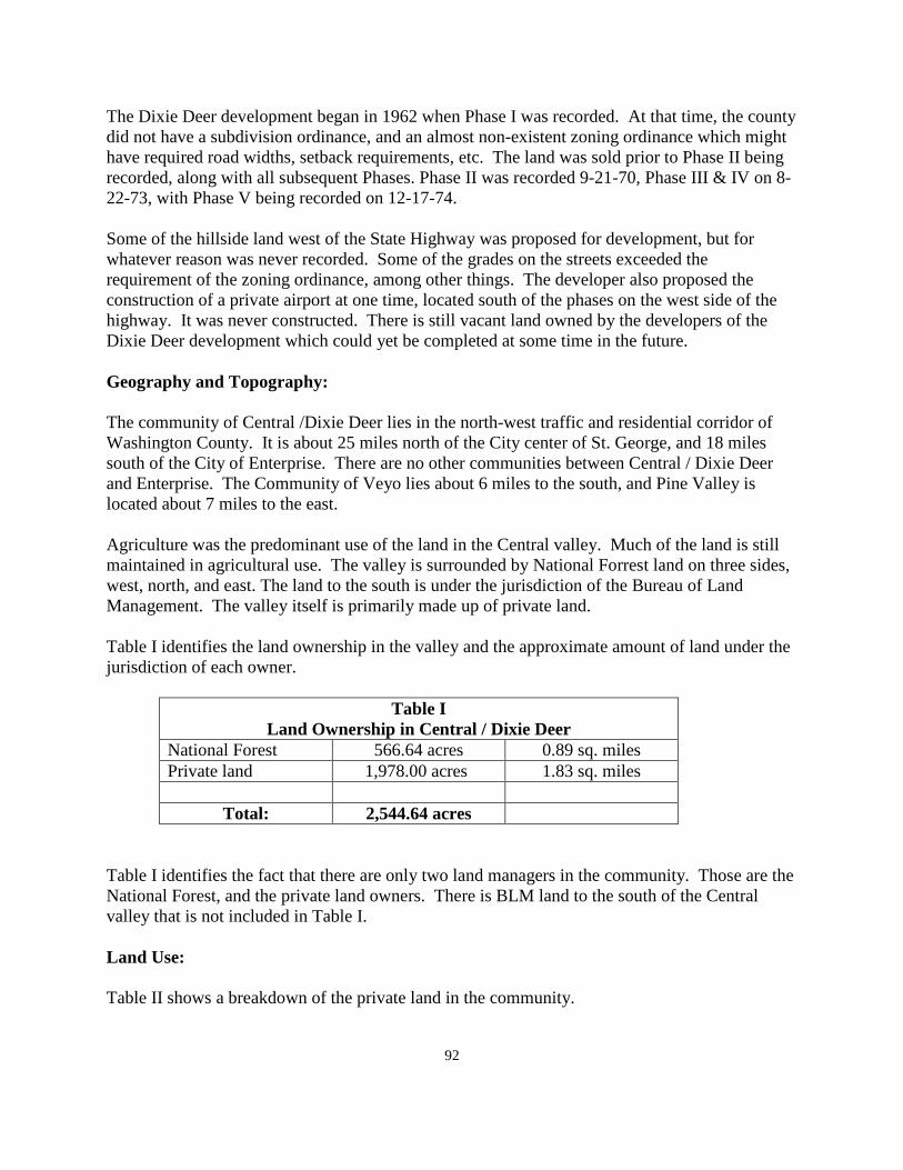
92
The Dixie Deer development began in 1962 when Phase I was recorded. At that time, the county did not have a subdivision ordinance, and an almost non-existent zoning ordinance which might have required road widths, setback requirements, etc. The land was sold prior to Phase II being recorded, along with all subsequent Phases. Phase II was recorded 9-21-70, Phase III & IV on 8-22-73, with Phase V being recorded on 12-17-74. Some of the hillside land west of the State Highway was proposed for development, but for whatever reason was never recorded. Some of the grades on the streets exceeded the requirement of the zoning ordinance, among other things. The developer also proposed the construction of a private airport at one time, located south of the phases on the west side of the highway. It was never constructed. There is still vacant land owned by the developers of the Dixie Deer development which could yet be completed at some time in the future. Geography and Topography: The community of Central /Dixie Deer lies in the north-west traffic and residential corridor of Washington County. It is about 25 miles north of the City center of St. George, and 18 miles south of the City of Enterprise. There are no other communities between Central / Dixie Deer and Enterprise. The Community of Veyo lies about 6 miles to the south, and Pine Valley is located about 7 miles to the east. Agriculture was the predominant use of the land in the Central valley. Much of the land is still maintained in agricultural use. The valley is surrounded by National Forrest land on three sides, west, north, and east. The land to the south is under the jurisdiction of the Bureau of Land Management. The valley itself is primarily made up of private land. Table I identifies the land ownership in the valley and the approximate amount of land under the jurisdiction of each owner.
Table I Land Ownership in Central / Dixie Deer
National Forest 566.64 acres 0.89 sq. miles Private land 1,978.00 acres 1.83 sq. miles
Total: 2,544.64 acres
Table I identifies the fact that there are only two land managers in the community. Those are the National Forest, and the private land owners. There is BLM land to the south of the Central valley that is not included in Table I. Land Use: Table II shows a breakdown of the private land in the community.
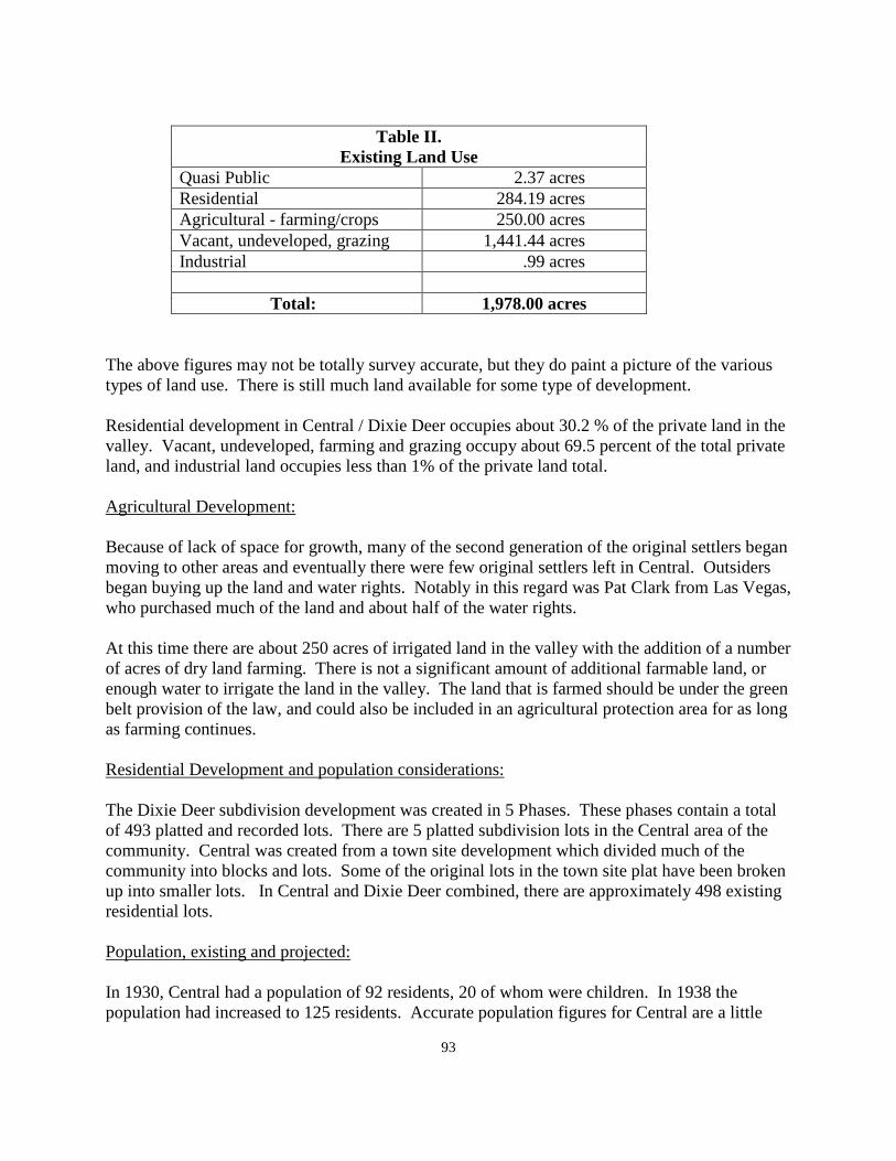
93
Table II.
Existing Land Use Quasi Public 2.37 acres Residential 284.19 acres Agricultural - farming/crops 250.00 acres Vacant, undeveloped, grazing 1,441.44 acres Industrial .99 acres
Total: 1,978.00 acres
The above figures may not be totally survey accurate, but they do paint a picture of the various types of land use. There is still much land available for some type of development. Residential development in Central / Dixie Deer occupies about 30.2 % of the private land in the valley. Vacant, undeveloped, farming and grazing occupy about 69.5 percent of the total private land, and industrial land occupies less than 1% of the private land total. Agricultural Development: Because of lack of space for growth, many of the second generation of the original settlers began moving to other areas and eventually there were few original settlers left in Central. Outsiders began buying up the land and water rights. Notably in this regard was Pat Clark from Las Vegas, who purchased much of the land and about half of the water rights. At this time there are about 250 acres of irrigated land in the valley with the addition of a number of acres of dry land farming. There is not a significant amount of additional farmable land, or enough water to irrigate the land in the valley. The land that is farmed should be under the green belt provision of the law, and could also be included in an agricultural protection area for as long as farming continues. Residential Development and population considerations: The Dixie Deer subdivision development was created in 5 Phases. These phases contain a total of 493 platted and recorded lots. There are 5 platted subdivision lots in the Central area of the community. Central was created from a town site development which divided much of the community into blocks and lots. Some of the original lots in the town site plat have been broken up into smaller lots. In Central and Dixie Deer combined, there are approximately 498 existing residential lots. Population, existing and projected: In 1930, Central had a population of 92 residents, 20 of whom were children. In 1938 the population had increased to 125 residents. Accurate population figures for Central are a little
94
hard to substantiate. A figure from 1940 showed 70 residents and another figure from 1970 showed a total of 15 residents. After the Dixie Deer subdivision began to be developed, the population has increased for every year since that project began. There have been 73 new building permits issued over the past ten years. There are 498 total lots in the community area. Of that total, 349 lots contain dwelling units. Using the population figures from those responding to the questionnaire, the community has an average of two persons per dwelling unit. This would create a population of about 700 persons. Using the average family size county wide, the average number per dwelling would be three persons per dwelling unit, or a total existing population of 1,100 persons. There are additionally 149 vacant lots in the Dixie Deer subdivisions, which includes about 11 vacant lots platted in Central. Using the same population figures this would add between 300 to 450 residents to the community for a total build out population of between 1,000 and 1,600 residents as a build-out population. There is still undeveloped land in the Dixie Deer area, more undeveloped land in the Central part of the community. This land, if developed, could add significantly more residents to the area and increase the population accordingly. A lack of culinary water could be the greatest restriction to growth in both of these community areas, without which, the population projections would show growth up to the extent that culinary connections are available. Vision Dixie Summary: According to the response from the questionnaire circulated in the community, none of the respondents from this community participated in the Vision Dixie study that was undertaken by the county a few years ago. The outgrowth of the study and recommendations by the committee charged with reviewing the material collected was a series of guidelines and policies aimed at guiding future growth in the county. The summary of the Vision Dixie study, adopted by the county and most of the incorporated cities and towns in the county is summarized for the residents of Central/Dixie Deer estates as follows: 1. Plan regionally, implement locally - The General Plan for Central/Dixie Deer is a locally
prepared plan for this area of the county only, and is a part of the overall county General Plan. It deals with aspects of the future of the Central/Dixie Deer valley and may be amended from time to time as necessary, dealing with the concerns of this community, and not related to the county at large.
2. Maintain air and water quality, and conserve water - This community has a high standard
of air quality. The low population density of this community, and the separation of this area from other more urban areas of the county help to maintain good air quality. Water conservation is necessary because of the limited amount of water that is available here.
95
3. Guard our signature landscapes - The surrounding hillsides of this community are maintained in an open space category on public land. With the Vision Dixie principles in place, it can be expected that the surrounding view sheds on the public land will be protected.
4. Provide connected natural recreation areas and open spaces - Most of the surrounding
public land areas provide considerable natural recreation areas. The Pine Valley recreation area is very close to this community as is the Pine Valley wilderness area. In addition, there are numerous roads and trails that are available to residents of this community for natural outdoor recreation. There are probably more natural outdoor recreation areas available to residents living here than anywhere else in the county.
5. Build an balanced transportation system - There is no public transportation system
available to residents of Central / Dixie Deer. If a public transportation system was ever developed between St. George City and the City of Enterprise, This community would benefit from being located along the State Highway between these two cities. Until that time, there will be no public system between the Central valley and the City of St. George.
6. Get centered by focusing on growth in walk-able mixed use centers - The community of
Central is generally walk-able as is much of the Dixie Deer subdivision. The Vision Dixie study recommended that dwellings should be located within three-quarters of a mile from a commercial center. There are no commercial facilities located in the community, but if such a center was developed on the north side of the Pine Valley road near the intersection with Highway 18, many of the residents could walk to that location and be within the distance recommended by the Vision Dixie plan.
7. Direct growth inward - All of the growth in the Dixie Deer subdivision has been
contained within the platted and recorded plats. Virtually all of the development in the Central area has also been in the area that was platted for residential development in the town site plat. The community has done very well in complying with the policy of the Vision Dixie Plan in directing growth inward.
8. Provide a wide range of housing types - This policy works well in the urbanized county
locations where sewer service is available. It does not work in the unincorporated areas of the county where sewer service is not available. The soil conditions in the county make it very difficult to provide mixed development, or high density residential development using septic tanks.
9. Reserve areas for Industry - There is one parcel of property in the community that can be
identified as an industrial site. It is more of an equipment storage yard than an actual industrial site.
The community of Central / Dixie Deer does not lend itself to industrial development because of the distance of the community from a major transportation site. If there were industrial products being produced in the community, then it would be a question of
96
moving them to the market. In this case, there are no locally produced products. Therefore, it would be necessary to bring the materials to the site before creating the product and then moving it to the market place. The community is not an area where industrial development is likely to take place.
10. Public land conversion - The community of Central / Dixie Deer is surrounded by public
land, particularly the National Forest. None of this land is identified as being necessary for future development of the community other than a small parcel of Forest land that is needed to connect Phase I and Phase II of the Dixie Deer development together.
Commercial Development: One goal of the Vision Dixie Plan is to try to make communities as sustainable as possible. This means that residents should be able to find work where they live, and that circulation through the community might be better with walking and bike trails as opposed to automobiles. Relative to commercial development in the community, the questionnaires returned by the residents attending the planning meeting held here last summer indicated that there was no desire to have commercial development here. Suggestions for commercial development included Enterprise, St. George, and Veyo. Veyo has been identified by all of the other "west side" developments as a suitable for commercial development. It does fit the definition as a satellite commercial site according to the Vision Dixie Plan. Many years ago, as a part of the development, Phase I of the Dixie Deer development included the development of a restaurant and motel facility. This facility continued to be used for a number of years, but eventually closed and has not been used for many years. In fact, it has been recommended that this commercial building be torn down and removed from the community as being a danger in its current condition. The General Plan would recommend that the building be inspected to determine whether or not the county could require its tearing down and elimination. If it is a community hazard, the county could facilitate its removal. If not, it would be a private issue with the owner of the property. The General Plan does not recommend commercial development in this community. However, should economic conditions dictate that commercial development was desirable, the location near the intersection of the Pine Valley road and State Highway 18, would be one location where commercial development could take place. It is a spot where residential development is not likely to take place and would be within the distance recommended by the Vision Dixie Plan where commercial development would be within an acceptable distance from existing development. While the General Plan would identify the above site as having commercial potential in keeping with the Vision Dixie Plan, it should be indicated that the General Plan is not suggesting that this location be developed in an effort to attract commercial business from either the Pine Valley
97
road or the State Highway. It should only be developed to serve local needs which would require that there be an economic basis for commercial development to take place in the community. There is one facility that was recently approved in the community that does have commercial characteristics related to it. This is the motocross facility that was approved by conditional use permit by the County Planning Commission about one year ago located near the eastern edge of the community. After being approved for one year, the facility has recently been approved for permanent status by the planning commission. There were evidently no complaints received by the county over the past year that would indicate any local concerns with the facility. Industrial Development: Industrial development was discussed briefly during the section summarizing the vision Dixie Plan dealing with industry. There is no industrial development in the Central/ Dixie Deer area. There is one facility that is classified as a contractor storage yard located along State Highway 18. This facility has been there for a number of years. The owners have made efforts from time to time to beautify the area and to screen it from adjacent uses. There are no residential uses located adjacent to the site. Public Services: A section of the General Plan dealing with public services county-wide is located in Section VII of the General Plan. This section of the Plan will be adopted in connection with the adoption of the various community plans and is not currently a part of the General Plan. Some comments specific to the Central / Dixie Deer plan are re-stated here as they relate specifically to this community. Electricity: Electric service to Central / Dixie Deer is provided by the Rocky Mountain power company. This company has recently upgraded their distribution lines from the Red Butte distribution center. The main distribution line from Sigurd to the Red Butte station is also being upgraded. With these upgrades, the power company feels that they should be able to provide electrical service to the west side of the county for a long time to come. The citizens generally gave their electrical service good marks in terns of reliable service to the community. The ability to provide good service to the residents should be able to continue for a long period of time. Natural Gas: There is a major natural gas distribution line that currently parallels State Highway 18 and runs between the Red Butte sub-station, and joins a comparable line coming into the county from the
98
east side of the county to St. George City. These lines provide a stable source of natural gas to the county and to most of the communities therein. Water: Water in the community is provided from two separate sources. The Central area is served by the Central SSD culinary water system, and the Dixie Deer area is served by the Dixie Deer culinary water system. When the Dixie Deer development took place, Central town, as it was at that time, did not have sufficient water to serve the Dixie Deer development. The Dixie Deer developers provided their own system which later formed the DDSSD, and the two systems have remained as separate companies. Neither system has sufficient resources to allow any significant expansion. If the Dixie Deer system can provide for all of the currently undeveloped lots in the subdivision, it cannot provide water for any significant expansion. The Central water system is in about the same situation. Additional water for culinary use in the community is the major restriction to future growth and expansion. There is also a limited amount of irrigation water available in the Central area. The current supply is completely subscribed to by those owning the water shares for irrigation. There is land that could be irrigated if additional water was available. Sewage Disposal: Central / Dixie Deer Estates is served by septic tanks. Because of poor soil conditions in a few areas of Dixie Deer Estates, two of the lots there are served by what amounts to individual sewage treatment systems. This type of system has been approved by the Department of Environmental Quality for large scale use in areas where normal septic tank development is not feasible. It is not recommended as an alternative to septic tanks. There is still room for additional development in the valley that could probably be served with septic tanks, assuming that sufficient culinary water was available to support additional development. Roads: All of the roadways in the Central town site plat, along with the recorded phases of the Dixie Deer development, are county roads. The policy of the county is to maintain the county roads in the same condition that they were developed by the developer. For this reason, all of the roads in the valley are not maintained at the same standard. The county will assist property owners to improve the roads in their particular area by assisting in the creation of improvement districts to allow the roads to be brought to a higher standard and paid for over a period of time, usually a ten year period. In Phase II of the Dixie Deer development, there was no access provided from Phase I into Phase II. There is a roadway that ends with a temporary cul-de-sac against the National Forest boundary with the intent that it be extended inside the forest boundary to an existing road in
99
Phase I, thereby linking those two phases together. The General Plan recommends that the county make contact with the forest service officials to identify the feasibility of opening a roadway along the forest boundary to link these two phases of the Dixie Deer development together. It needs to be done. Little by little the Department of Transportation (UDOT) has been widening the State Highway north from St. George. This improvement of the State Highway should continue over time, until a four lane highway is developed from St. George to the Pine Valley Road in the community of Central / Dixie Deer. From here is should continue to be improved to the City of Enterprise. This is the same method that was used to improve Highway 9 from the Interstate Freeway to the downtown area of the City of Hurricane. It can be done a little at a time over a period of several years to achieve significant improvement to the State Highway system in the county. Fire Protection: The Central / Dixie Deer community maintains a volunteer fire department. It is a part of the North West Fire District. The department participates with the Washington County Fire Chiefs association. The volunteer members of the department also participate in training programs with the North West fire District. The department is on call to assist with fires outside of the community area as may be needed to assist fire departments elsewhere in the county. The department needs to continue making improvements to meet the needs of the community. Public Safety: Police protection in the valley is provided by the Washington County Sheriff's Office. This service will continue as long as they are continue to be an unincorporated part of Washington County. Some communities in the county who desire greater protection have contracted with the county for increased visibility of the sheriff's deputies in exchange for additional funds being raised by the community. Solid Waste: The County Solid Waste Board is made up of one representative from each city or town along with one member from the county. This committee oversees the collection of solid waste in the county. There is a central landfill location which is owned by Washington County and managed by the solid waste company. This site is expected to be sufficient for many years to come. The system of management and oversight is also expected to continue. Overall, the solid waste program in the county is recommended by the General Plan and currently works very well. In addition to the land fill location, there are several satellite collection sites in the county where waste and used materials can be disposed of. One such facility is located in this community along the State Highway. The General Plan recommends that this facility continue to be maintained for the residents in this part of the county.
100
Building Inspection: Building inspection for dwelling units and other types of building construction are provided by the County Building Department. The cost of building permits is established to defray the cost of inspection during the period of construction. Building permit fees in the unincorporated communities are significantly less than found in most of the incorporated cities and towns in the county. Communication: Most of Washington County is served by the CenturyLink communication company. In addition to CenturyLink services, there are a number of private cellular companies providing service within the county. None of these communication services were given high ratings by the residents of the area. However, both CenturyLink and cellular services were judged to generally be adequate. Improvements to communication services in the community should continually be improved and upgraded when possible to do so. Flood Control: Flood control is not identified by residents as a major problem in the Central / Dixie Deer community. The Santa Clara River runs through the easterly end of the community, and except for some problems with the river crossing at times of high water, no other problems have been identified in the General Plan. Incorporation: One final issue related to public services is the question of incorporation. Under Utah State Law, a petition for incorporation must originate from the community that desires to pursue this alternative. The General Plan suggests that incorporation is not a serious question for this community. Further, there are no incorporated cities of towns near enough that annexation would be a possibility. The county feels that the government that is closest to the people is the best form of government. The minimum number of residents required to request incorporation is 100 persons. The county does not oppose incorporation of a community. The county is not promoting the incorporation of the unincorporated communities in the county, but would lend support to whatever decision the community might make.
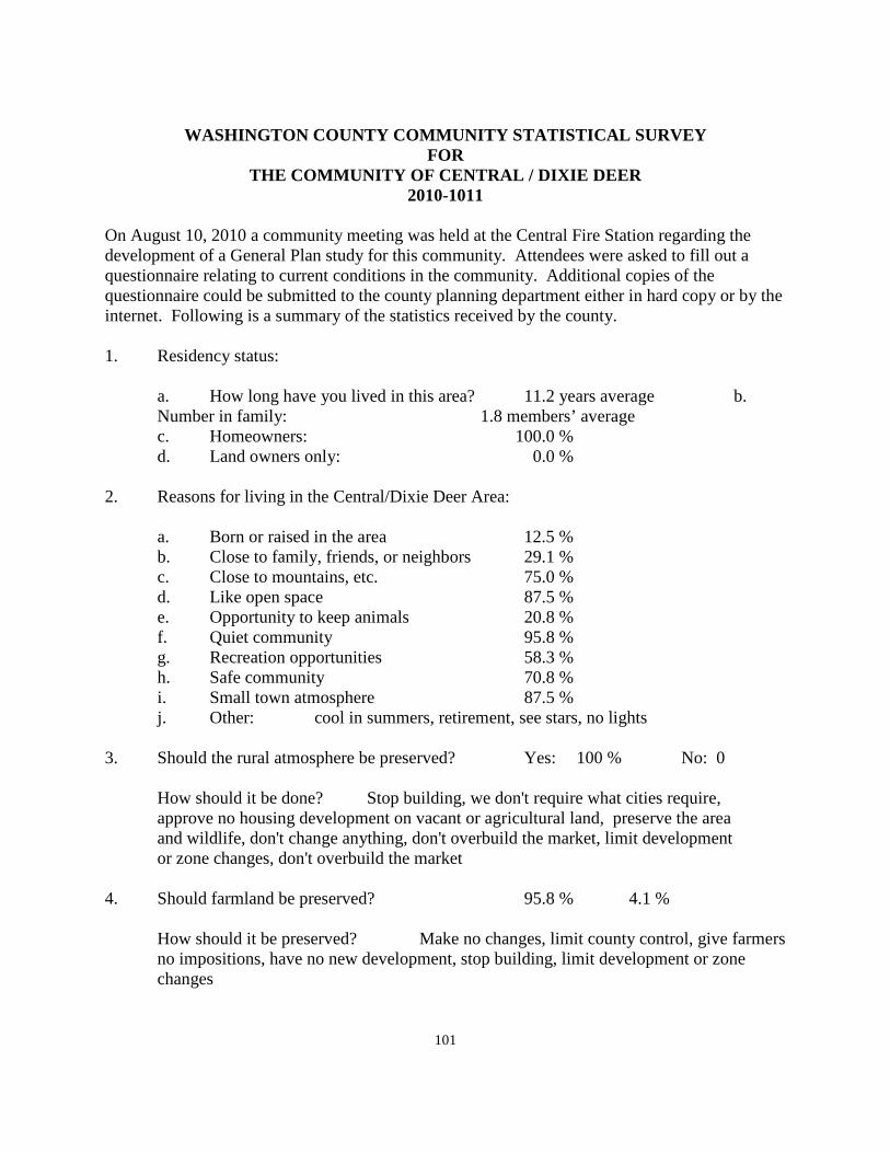
101
WASHINGTON COUNTY COMMUNITY STATISTICAL SURVEY
FOR THE COMMUNITY OF CENTRAL / DIXIE DEER
2010-1011
On August 10, 2010 a community meeting was held at the Central Fire Station regarding the development of a General Plan study for this community. Attendees were asked to fill out a questionnaire relating to current conditions in the community. Additional copies of the questionnaire could be submitted to the county planning department either in hard copy or by the internet. Following is a summary of the statistics received by the county. 1. Residency status: a. How long have you lived in this area? 11.2 years average b. Number in family: 1.8 members’ average c. Homeowners: 100.0 % d. Land owners only: 0.0 % 2. Reasons for living in the Central/Dixie Deer Area: a. Born or raised in the area 12.5 % b. Close to family, friends, or neighbors 29.1 % c. Close to mountains, etc. 75.0 % d. Like open space 87.5 % e. Opportunity to keep animals 20.8 % f. Quiet community 95.8 % g. Recreation opportunities 58.3 % h. Safe community 70.8 % i. Small town atmosphere 87.5 % j. Other: cool in summers, retirement, see stars, no lights 3. Should the rural atmosphere be preserved? Yes: 100 % No: 0 How should it be done? Stop building, we don't require what cities require, approve no housing development on vacant or agricultural land, preserve the area and wildlife, don't change anything, don't overbuild the market, limit development or zone changes, don't overbuild the market 4. Should farmland be preserved? 95.8 % 4.1 %
How should it be preserved? Make no changes, limit county control, give farmers no impositions, have no new development, stop building, limit development or zone changes
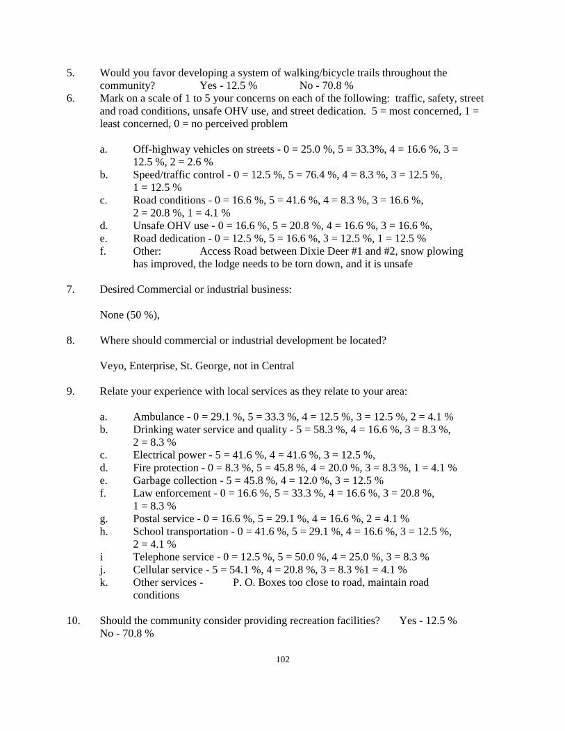
102
5. Would you favor developing a system of walking/bicycle trails throughout the community? Yes - 12.5 % No - 70.8 % 6. Mark on a scale of 1 to 5 your concerns on each of the following: traffic, safety, street
and road conditions, unsafe OHV use, and street dedication. 5 = most concerned, 1 = least concerned, 0 = no perceived problem
a. Off-highway vehicles on streets - 0 = 25.0 %, 5 = 33.3%, 4 = 16.6 %, 3 = 12.5 %, 2 = 2.6 % b. Speed/traffic control - 0 = 12.5 %, 5 = 76.4 %, 4 = 8.3 %, 3 = 12.5 %, 1 = 12.5 % c. Road conditions - 0 = 16.6 %, 5 = 41.6 %, 4 = 8.3 %, 3 = 16.6 %, 2 = 20.8 %, 1 = 4.1 % d. Unsafe OHV use - 0 = 16.6 %, 5 = 20.8 %, 4 = 16.6 %, 3 = 16.6 %, e. Road dedication - 0 = 12.5 %, 5 = 16.6 %, 3 = 12.5 %, 1 = 12.5 % f. Other: Access Road between Dixie Deer #1 and #2, snow plowing has improved, the lodge needs to be torn down, and it is unsafe 7. Desired Commercial or industrial business: None (50 %), 8. Where should commercial or industrial development be located? Veyo, Enterprise, St. George, not in Central 9. Relate your experience with local services as they relate to your area: a. Ambulance - 0 = 29.1 %, 5 = 33.3 %, 4 = 12.5 %, 3 = 12.5 %, 2 = 4.1 % b. Drinking water service and quality - 5 = 58.3 %, 4 = 16.6 %, 3 = 8.3 %, 2 = 8.3 % c. Electrical power - 5 = 41.6 %, 4 = 41.6 %, 3 = 12.5 %, d. Fire protection - 0 = 8.3 %, 5 = 45.8 %, 4 = 20.0 %, 3 = 8.3 %, 1 = 4.1 % e. Garbage collection - 5 = 45.8 %, 4 = 12.0 %, 3 = 12.5 % f. Law enforcement - 0 = 16.6 %, 5 = 33.3 %, 4 = 16.6 %, 3 = 20.8 %, 1 = 8.3 % g. Postal service - 0 = 16.6 %, 5 = 29.1 %, 4 = 16.6 %, 2 = 4.1 % h. School transportation - 0 = 41.6 %, 5 = 29.1 %, 4 = 16.6 %, 3 = 12.5 %, 2 = 4.1 % i Telephone service - 0 = 12.5 %, 5 = 50.0 %, 4 = 25.0 %, 3 = 8.3 % j. Cellular service - 5 = 54.1 %, 4 = 20.8 %, 3 = 8.3 %1 = 4.1 % k. Other services - P. O. Boxes too close to road, maintain road conditions 10. Should the community consider providing recreation facilities? Yes - 12.5 % No - 70.8 %
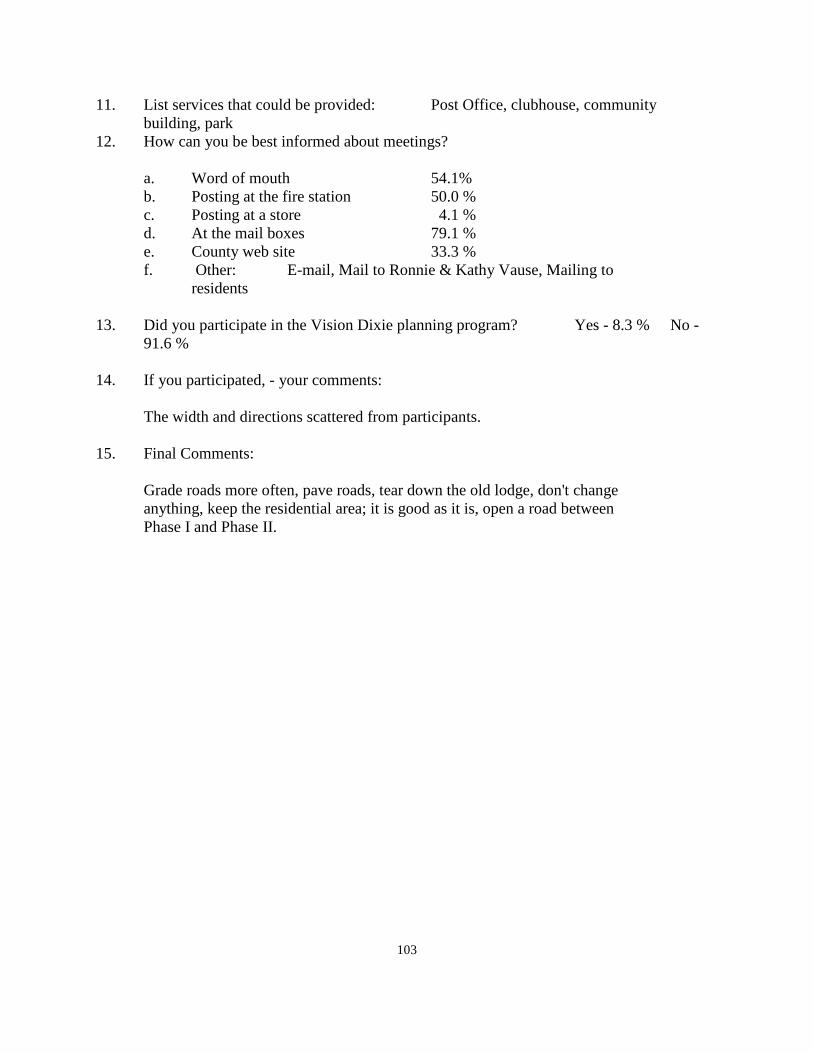
103
11. List services that could be provided: Post Office, clubhouse, community building, park 12. How can you be best informed about meetings? a. Word of mouth 54.1% b. Posting at the fire station 50.0 % c. Posting at a store 4.1 % d. At the mail boxes 79.1 % e. County web site 33.3 % f. Other: E-mail, Mail to Ronnie & Kathy Vause, Mailing to residents 13. Did you participate in the Vision Dixie planning program? Yes - 8.3 % No -
91.6 % 14. If you participated, - your comments: The width and directions scattered from participants. 15. Final Comments: Grade roads more often, pave roads, tear down the old lodge, don't change anything, keep the residential area; it is good as it is, open a road between Phase I and Phase II.
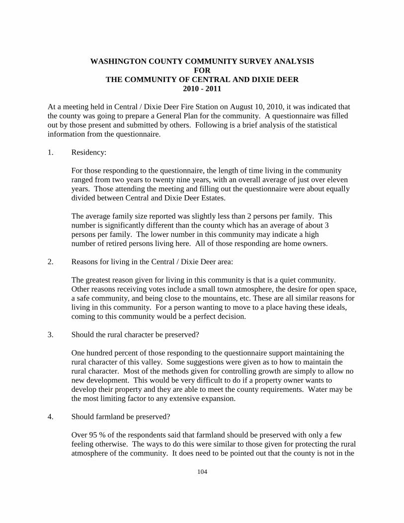
104
WASHINGTON COUNTY COMMUNITY SURVEY ANALYSIS
FOR THE COMMUNITY OF CENTRAL AND DIXIE DEER
2010 - 2011
At a meeting held in Central / Dixie Deer Fire Station on August 10, 2010, it was indicated that the county was going to prepare a General Plan for the community. A questionnaire was filled out by those present and submitted by others. Following is a brief analysis of the statistical information from the questionnaire. 1. Residency:
For those responding to the questionnaire, the length of time living in the community ranged from two years to twenty nine years, with an overall average of just over eleven years. Those attending the meeting and filling out the questionnaire were about equally divided between Central and Dixie Deer Estates.
The average family size reported was slightly less than 2 persons per family. This number is significantly different than the county which has an average of about 3 persons per family. The lower number in this community may indicate a high number of retired persons living here. All of those responding are home owners. 2. Reasons for living in the Central / Dixie Deer area:
The greatest reason given for living in this community is that is a quiet community. Other reasons receiving votes include a small town atmosphere, the desire for open space, a safe community, and being close to the mountains, etc. These are all similar reasons for living in this community. For a person wanting to move to a place having these ideals, coming to this community would be a perfect decision.
3. Should the rural character be preserved?
One hundred percent of those responding to the questionnaire support maintaining the rural character of this valley. Some suggestions were given as to how to maintain the rural character. Most of the methods given for controlling growth are simply to allow no new development. This would be very difficult to do if a property owner wants to develop their property and they are able to meet the county requirements. Water may be the most limiting factor to any extensive expansion.
4. Should farmland be preserved?
Over 95 % of the respondents said that farmland should be preserved with only a few feeling otherwise. The ways to do this were similar to those given for protecting the rural atmosphere of the community. It does need to be pointed out that the county is not in the
105
development business. Development originates with some property owner selling their property to another person who wants to create a development.
The county neither promotes development nor opposes development by persons who meet the current county subdivision ordinances. While the county is not promoting incorporation, the best way for a community to control their own destiny would be to incorporate.
5. Would you favor developing a system of walking/bicycle trails throughout the community?
Most of the residents indicated that they are not in favor of such a system. The traffic on the local streets in both Central and Dixie Deer are not high traffic roadways. Any of them can be used for walking or riding bicycles without creating a separate system of trails at no additional cost to the community.
6. Mark on a scale of 1 to 5 your concerns on each of the following: Traffic, safety, street
and road conditions, unsafe OHV use, street dedication, with 5 being the most concerned, 1 being the least concerned, and 0 meaning there is no perceived problem.
The largest concern expressed is for speeding vehicles through the community. This could be on the internal roads, but likely is directed to the State Highway or to the highway leading to Pine Valley. Of the other concerns listed, none reach the level of being major concerns.
Several of the concerns have a moderate amount of concern, but overall, residents seem to be satisfied with off-highway vehicles, road conditions, or unsafe OHV use. The least concern listed relates to road dedication. Most of the roads in the community are dedicated roadways so it is an easy item to draw the least amount of concern.
7. Desired commercial or industrial business:
The residents mostly listed "none" as the greatest need for business in the community. Most residents are quite satisfied with not having commercial or industrial business available close by.
8. Where should commercial or industrial development be located?
Enterprise, St. George, and Veyo were all listed as good locations for these uses to take place. These responses are very similar to the response found in most of the "west side" communities. Many in Veyo were also opposed to additional commercial development. Veyo, is located centrally between two communities to the south, three to the north, and one to the west. Veyo may become a center for business simply by location as much as by desire.
9. Relate your experience with local services as they relate to your area:
106
None of the services listed in the questionnaire received particularly high ratings. Water
quality and service rated nearly 60 %, and telephone service and cellular services rated in the 50% level. For most other services the 40% ratio identified the level of satisfaction with most services.
The lowest ratings were given to ambulance service, for which less was known about the level of service. Postal Service was also given a low rating with a number suggesting that they would like to have a post office in the community, or that the current location of mail boxes was somewhat of a safety hazard. There is not a likelihood of a new Post Office because of the cutbacks in postal service that are and will probably take place. By working with the Post Office, it may be possible to re-locate the existing boxes to a location away from the main highway to Pine Valley.
10. Should the community consider providing recreation facilities?
12.5 % of the residents indicated that recreation facilities would be desirable while over 70% of the residents indicated that none were needed.
11. List services that could be provided? Several types of recreation, or other facilities were listed in the questionnaire. 12. How can you best be informed about meetings?
Posting at the mail boxes was the highest recommended location for posting notices. Word of mouth and posting at the fire station also received high votes. Mailing to residents is not a viable option because of the cost involved in sending individual notices to residents of the county.
13. Did you participate in the Vision Dixie planning program?
Over 90 % of the respondents to the questionnaire did not participate in this program. However there were a few community residents who did participate.
14. There were no significant comments made relative to comments of participants in the
Vision Dixie planning program. 15. Final comments:
Several citizens identified the unsafe condition of the old lodge as a danger to the community and a building that should be torn down. The lodge is privately owned and would need to be identified as a community hazard before the county could become involved.

107
Many citizens identified the need for a roadway linking Phase I of Dixie Deer with Phase 2 of that development as being a significant need that should be looked at to see if there is any possibility of making such a connection. These were the major concerns in the community. Many citizens indicated that they liked the community as it is as a desirable place to live.
108
THE GENERAL PLAN
FOR CLIFF DWELLERS, GRASSY MEADOWS SKY RANCH,
AND HURRICANE CLIFF ESTATES 2010 - 2011
Introduction: Cliff Dwellers, Grassy Meadows Sky Ranch, and Hurricane Cliff Estates are in an unincorporated part of Washington County. Residents and others should take time to review Section I of the County General Plan which discusses planning in general, the basis for planning, and the purpose of planning. Many of the things mentioned in the beginning of Section VII of the County General Plan are also relevant to the residents of this part of the county. The General Plan provides guidelines for the future of this particular part of the county in addition to those things that are applied county-wide in the other sections of the General Plan. The development in this part of the county came about over a number of years. Three subdivision developments have been recorded in the area. These were the Grassy Meadows Sky Ranch subdivision that was recorded in six phases beginning in August 1984, the Cliff Dwellers Subdivision that was recorded in two phases beginning in June 1993, and the Hurricane Cliff Estates subdivision recorded on October 1, 2004.
Recently, the City of Hurricane annexed county property south of the Hurricane City Airport to Sand Hollow Reservoir and Eastward to the base of the Hurricane cliffs. Except for a small connection of this community to land under the jurisdiction of the Bureau of Land Management, the area of Cliff Dwellers, Grassy Meadows Sky Ranch, and Hurricane Cliff Estates is now a peninsula almost completely surrounded by the City of Hurricane. The residents of this community chose not to be annexed to Hurricane City at that time, and therefore, is still a part of unincorporated Washington County. Geography and Topography: The Cliff Dwellers / Grassy Meadows Sky Ranch / Hurricane Cliffs community lies in a long valley bounded on the East by the 1,000 foot high Hurricane Cliffs, and on the West by lower rolling hills that lie between this valley and the Sand Hollow Reservoir. The bottom of the valley is relatively flat but much of the development lies on the hills sloping toward the West. The valley itself lies in the south-central part of Washington County and extends nearly to the Arizona Border. One of the features of this area is the location of a privately owned airport. This airport provided the basis for this community in the very beginning. The airport landing strip is adjacent to building lots which allows home owners to land their airplane and then taxi to a hanger which is a part of their individual dwelling unit. This is the only facility of its kind anywhere in the county, or in any surrounding area. It is unique to the Grassy Meadows Sky Ranch part of this community.
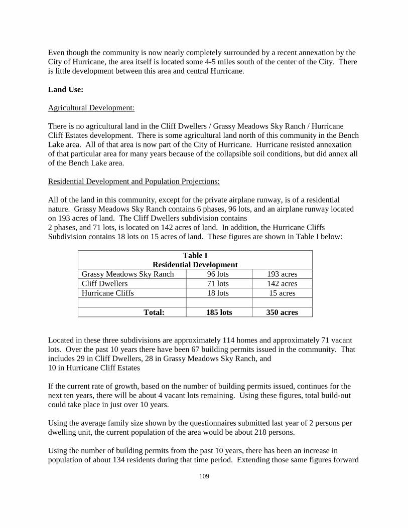
109
Even though the community is now nearly completely surrounded by a recent annexation by the City of Hurricane, the area itself is located some 4-5 miles south of the center of the City. There is little development between this area and central Hurricane. Land Use: Agricultural Development: There is no agricultural land in the Cliff Dwellers / Grassy Meadows Sky Ranch / Hurricane Cliff Estates development. There is some agricultural land north of this community in the Bench Lake area. All of that area is now part of the City of Hurricane. Hurricane resisted annexation of that particular area for many years because of the collapsible soil conditions, but did annex all of the Bench Lake area. Residential Development and Population Projections: All of the land in this community, except for the private airplane runway, is of a residential nature. Grassy Meadows Sky Ranch contains 6 phases, 96 lots, and an airplane runway located on 193 acres of land. The Cliff Dwellers subdivision contains 2 phases, and 71 lots, is located on 142 acres of land. In addition, the Hurricane Cliffs Subdivision contains 18 lots on 15 acres of land. These figures are shown in Table I below:
Table I Residential Development
Grassy Meadows Sky Ranch 96 lots 193 acres Cliff Dwellers 71 lots 142 acres Hurricane Cliffs 18 lots 15 acres Total: 185 lots 350 acres
Located in these three subdivisions are approximately 114 homes and approximately 71 vacant lots. Over the past 10 years there have been 67 building permits issued in the community. That includes 29 in Cliff Dwellers, 28 in Grassy Meadows Sky Ranch, and 10 in Hurricane Cliff Estates If the current rate of growth, based on the number of building permits issued, continues for the next ten years, there will be about 4 vacant lots remaining. Using these figures, total build-out could take place in just over 10 years. Using the average family size shown by the questionnaires submitted last year of 2 persons per dwelling unit, the current population of the area would be about 218 persons. Using the number of building permits from the past 10 years, there has been an increase in population of about 134 residents during that time period. Extending those same figures forward
110
for the next ten years would show a population increase of an additional 134 persons for a 10 year projected total of 352 residents in the community. One variable to these projections is the large parcel of vacant land that currently exists within the community that is a part of Grassy Meadows Sky Ranch. Several years ago a Master Plan for this area was approved by the county as a Planned Development. This means that the current plan is the only thing approved to be built in the area. Because of the changes in the economy over the past 4 or 5 years, it is most likely that the developers of this property at some future time will approach the county to revise the current plan that was approved, and make adjustments to it based upon current development trends. To make any changes to the plan would require that the plan go back through the public hearing process to amend the existing Planned Development Zone classification. Residents of the area should be aware of this plan and be prepared to participate in public hearings and meetings at such time as any changes are proposed to the current plan. For the purpose of this General Plan, the land is shown as vacant / open space land, currently undeveloped. The area of the plan contains some 750 acres of land which is approximately double the amount of land currently developed. If fully developed, the vacant land area could double the population of the presently developed land. The other area which residents need to be aware of, and to monitor on a regular basis, is the future development of land that is now in the City of Hurricane. One large development was proposed in the county prior to annexation. Because of the current economic condition, this plan was never pursued. It will likely resurface at some future time in Hurricane City, and the residents of this community should be prepared to respond to any development proposals through the City of Hurricane. The long range future of this community lies in the hands of the City of Hurricane whether or not the community ever becomes part of that city. The Vision Dixie Summary: According to the questionnaire circulated in the area, very few of the residents of this part of the county participated in the Vision Dixie Planning project. The outgrowth of the study and the recommendations made by the committee charged with reviewing the material collected was a series of guidelines and politics aimed at guiding future growth and development in the county. A summary of the Vision Dixie study, adopted by the county and most of the incorporated cities and towns in the county is summarized for the residents of this community. Many of the Vision Dixie principles have more application in the incorporated areas than they do in the unincorporated areas that are currently developed, but some of the principles also have application in the unincorporated communities of the county. 1. Plan regionally, implement locally - The General Plan for this area of the county is
prepared for the residents of this area specifically, and it is also a part of the county-wide General Plan. This Plan deals with aspects of the future of this area and may be amended
111
or expanded from time to time as necessary, still dealing with the concerns of this area and not with the county at large.
2. Maintain air and water quality, and conserve water - Air and water quality is currently
very good. Water conservation is evident by the natural landscaping that is used in large measure by the residents of the community. Culinary water was generally rated as good by the residents.
3. Guard our signature landscapes - One of the attractions to development in this part of the
county is the open space character of the area and the visual qualities that exist in all directions. The existence of a mineral (gravel) operation along the base of the Hurricane Cliffs is part of the visual field. The view of the cliffs which rise some 1,000 feet above the valley floor still provides an outstanding view shed for the community. There are currently no restrictions on the view in the other directions.
4. Provide rich, connected natural recreation areas and open space - This community has
historically been surrounded by natural recreations areas and open space. To the extent that this condition will continue into the future will be up to the development policies of the City of Hurricane in which City all of the surrounding land is now located. However, it should be pointed out that there is a large quantity of private land surrounding this area that will not under any conditions be developed over the short term. The development of all of the private land surrounding this area will require decades in order for there to be significant changes. Growth in Washington County is currently developing very slowly, and even if the rate of growth increased to approximate the high rate of the early 2000's, it would require generations to fill in all of the land that was annexed by Hurricane City a few years ago.
5. Build a balanced transportation system - This policy relates to circulation in the
"urbanized" portions of the county. Currently only St. George City has a public transportation system that serves a portion of the city. This system does not extend to any of the adjacent cities to St. George City, and it could be years before public transportation regularly travels along the major corridors between Ivins and Springdale. Such a system is not likely to serve most of the unincorporated communities for many years into the future. There is nothing wrong with the policy except for a lack of funding, and the time it will take to see the system expanded throughout the county.
6. Get centered by focusing on growth in walkable mixed use centers - This unincorporated
community comes as close to being a walkable community as any other unincorporated community in the county. The development is very compact and is not spread out with large areas of no development between the various phases that have been developed.
It is a mixed use center in the fact that about half of the development is related to the airplane industry where home owners also own a hanger for their airplane, and about half of the residents are in typical single family homes. Where the Vision Dixie Plan refers to mixed use in terms of apartments, low or high rise residential mixed with typical single family development, the development in this area does not qualify. It was started as a
112
single family development and that is how is has proceeded up to this point. Based upon the need for septic tanks for waste disposal, the mixed use plan identified in the Vision Dixie Plan would only have potential for use in areas where sewer systems are available.
7. Direct growth inward - This is another policy where this community fits very well with
the Vision Dixie Plan. There are no development gaps between the three different developments, and because of the Hurricane City annexation, there is no possibility of having phases of development separated from the current land use. Even the possible future development of the vacant land would fit with the Vision Dixie Plan in terms of keeping growth from spreading out away from the current growth pattern.
8. Provide a broad range of housing types - This policy was mentioned above. It is not
possible in any of the unincorporated communities in the county to have a mixture of housing types because of a lack of sewage service. Septic tanks, as a means of disposal, allow only typical single family homes. There will not be any other type of development in the existing land areas, and on the vacant land changes could take place if provision is made as a part of the development to install an on site treatment facility.
9. Reserve areas for industry - This area of the county will never be an attractive site for
industry. It is too far distant from major transportation routes i.e. the Interstate Freeway System. The area was never planned for industry and the only industries that could exist in the nearby area are the gravel operations against the Hurricane Cliffs. These developments can be considered as industry, but only for local consumption and not for long distance transportation to other population centers.
10. Public land conversion - There is a connection from this development to land under the
jurisdiction of the Bureau of Land Management. The BLM land will not be required for the future expansion of this community.
Commercial Development: Commercial development is non-existent in this area of the county. The General Plan cannot identify any area in the existing community for commercial use as suggested by the Vision Dixie Plan. The General Plan does recommend that residents of the community oppose any form of "strip commercial" development along the roadway between here and the center of Hurricane City that may be proposed by developers on land in the city Industrial development: Industrial development has previously been discussed as one policy in the Vision Dixie Plan. The area does not lend itself to industrial development, if for no other reason than the distance from major transportation routes. There are mineral developments along the base of the Hurricane Cliffs. These facilities are located from the Arizona border north to the top of the Black Ridge. Unfortunately minerals are where you find them. These particular minerals, (Gravel), are where they are, and they are becoming very hard to find in most other areas of the
113
county. In the western part of the county along the Utah Hill area, most of the known deposits of gravel have been mined out. Washington County is going to continue to grow and gravel is a basic mineral necessity to make that happen. Public Services: A section of the General Plan dealing with public services s they relate county-wide is found at the beginning of this section, Section VII, of the County General Plan. Some comments are stated I this part of the plan as they relate specifically to the area of Cliff Dwellers / Grassy Meadows Sky Ranch / Hurricane Cliff Estates. Electricity: This community is provided with electrical power by the Rocky Mountain Power Company who has the franchise to serve most of this area of the county lying south of Hurricane City limits. This company has recently upgraded their distribution lines from the Red Butte distribution center. The main distribution line from Sigurd to the Red Butte station is also being upgraded. With these upgrades, the power company feels that they should be able to provide electrical service to its customers for many years into the future. Natural Gas: There is natural gas service available in Washington County. There is a main line that essential follows the I-15 Freeway and detours through Toquerville, LaVerkin, and Hurricane, and then continues to St. George. Another line comes through Enterprise and follows State Highway 18 to St. George. Unfortunately, unless a community is located along one of those main natural gas lines, natural gas is not available. That situation affects this area and the Gunlock area. Many of the unincorporated communities are along State Highway 18, and except for the cost of a pressure reducing valve, could have natural gas in their communities. Water: The water system for this area was originally developed by Mr. Longley as a part of the development of the community. The downturn in the economy has caused most development to be placed on hold. This caused the developer to sell the water company to the Washington County Water Conservancy District. They have the ability and capacity to supply water to the community well into the future. Sewage Disposal: This public service has been previously discussed in this plan in relation to residential development and the growth and development of the area. Presently the residents are served by septic tanks as the means of liquid disposal. One improvement that could be made to septic tanks would be to have the tanks inspected on an annual basis to determine their continued ability to provide the service for which they were installed. If they were inspected regularly and pumped as often as necessary for good
114
maintenance, they should continue to serve the needs of the area well into the future. An inspection and maintenance system could alleviate this potential concern. The General Plan would recommend that a maintenance system in the area be considered for the area at some time in the future. The current number of dwellings may not be sufficient at present to make this a viable option. Roads: The greatest concern about roads in the area is the concern about the road identified as 700 West in Hurricane and the Sky Ranch development. It has been a concern since the Sky Ranch development was completed. Because of the size of the development, and because Sky Ranch was a "leap frog" development several miles from the nearest development, the county became responsible for the upgrading of the road between Hurricane City and Sky Ranch, which the county was never able to do. The only significant change between then and now is the fact that Hurricane City has annexed all of the land between what was the former city limit and the development that has taken place in the Sky Ranch area. Whether Hurricane can do what the county was never able to do, and improve the roadway going south out of the former city limit to the Sky Ranch area remains to be seen. If other development comes to the area, the cost of road improvements outside of any new subdivision should be a part of the approval of the project. Fire Protection: The Cliff Dwellers / Grassy Meadows Sky Ranch / Hurricane Cliff Estates area is a part of the Hurricane Valley Fire District. In reality, fire protection services come from the City of Hurricane inasmuch as they have the fire protection services that are the closest to this valley. La Verkin and Toquerville are both a part of the Hurricane Valley Fire District, but their fire protection services are too far away from this community to provide a valid service. There is currently discussion relative to dissolving the Fire District after the end of 2011. If that should happen, it is likely that the City of Hurricane would again be responsible for fires in this community. Under Utah State Law, if a city is providing city services to an unincorporated area adjacent to their city, they could initiate annexation of the area to which they provide services and bring them into the city whether the unincorporated area wanted to be a part of the city or not. Under the currently undecided situation relative to the future of the Hurricane Valley Fire District, the General Plan recommends that no change take place and that the existing Fire District continue to provide service to the unincorporated areas within their boundary which includes this and other parts of the county. Solid Waste: The community, as an unincorporated part of the county, participates in the Washington County Solid Waste District. Pickup of waste in this area is collected in the same manner as it is in the various areas throughout the county. The county solid waste board is made up of one representative from each city or town along with one member from the county. This committee
115
oversees the collection of solid waste in the county. There is a central landfill location which is owned by Washington County and managed by the solid waste collection agency. This site is expected to be sufficient for many years to come. Overall, the solid waste program in the county is recommended by the General Plan and currently works very well. In addition to the landfill location and the door-to-door collection there are some satellite collection sites in various places in the county where waste materials can be disposed of. Building Inspection: Building inspection for dwelling units and other types of building construction are provided by the County Building Department. The cost of building permits is established to defray the cost of inspection during the period of construction. Building permit fees in the unincorporated communities are significantly less than are found in most of the incorporated cities and towns in the county. Communication: Most of Washington County is served by the CenturyLink communication company. In addition to CenturyLink services, there are a number of private cellular companies providing service within the county. The CenturyLink telephone system was generally rated as acceptable in the citizen questionnaire, but none of the cellular communication services were given acceptable ratings. Over time, cellular services will likely continue to improve. Flood Control: Flood control is not identified by residents as a major problem in the Cliff Dwellers and Grassy Meadows Sky Ranch Community. There are no major water courses in this area and no other significant problems have been identified in the General Plan. Incorporation / Annexation: One final issue related to public services is the question of incorporation. Under Utah State Law, a petition for incorporate must originate from the community that desires to pursue this alternatives. The General Plan suggests that even if the number of residents would approve incorporation of this area, being isolated from commercial or industrial services to support a tax base, the residential development in this community would make it difficult to support a self-contained community. A further problem with incorporation in this area is the fact that the City of Hurricane, through recent annexation, literally surrounds the community. Up to this point the community has declined to annex into the City of Hurricane, and can continue to do so. The county will support the community in whatever decisions that they might make now, or in the future, relative to this issue. The county would support annexation, and the county will continue to support the community being unincorporated. Whether to annex or not is a local decision. The community should be aware that the vacant land in the Sky Ranch area could someday develop; it is possible that the assessed value of the vacant area could exceed the value of the currently developed area.
116
In this case the vacant area residents could request annexation to Hurricane City and bring the current community into the city whether they wanted to be part of the city or not. That situation is many years into the future because of the time it would take the current vacant land to reach a "build-out" condition.
WASHINGTON COUNTY STATISTICAL SURVEY FOR
THE COMMUNITY OF CLIFF DWELLERS, GRASSY MEADOWS SKY RANCH, AND HURRICNE CLIFF ESTATES
2010 - 2011
In September 2010, a meeting was held at the Hurricane City Library regarding the development of a General Plan study for this unincorporated community area of Washington County. Attendees were asked to respond to a questionnaire related to the current conditions in the area. Additional copies could be submitted to the county planning department either in hard copy or over the internet. Following is a summary of the questionnaires received by the county. 1. Residency: a. How long have you lived in the area? 5.75 years b. Number in family: 2.0 c. Homeowner: 100 % 2. Reasons for living in this area: a. Born or raised in the area b. Close to family, friends, or neighbors 25.0 % c. Close to maintains, etc. 91.6 % d. Like open space 100.0 % e. Opportunity to keep animals 58.3 % f. Quiet community 100.0 % g. Recreation opportunities 58.3 % h. Safe community 91.6 % i. Small town atmosphere 100.0 j. Other: Private airport with home access, views, (before cell tower), dark sky, airport 3. Should the rural atmosphere be preserved? Yes: 100.0 % No:
How should it be done? Limit lot sizes, no lots less than one acre, buy land for non development, limit development, keep the area green, no commercial, keep low density, don't build, do not annex
117
4. Should farmland be preserved? Yes: 66.6 % No:
How should it be done? Create community co-op's, have no building on collapsible soil, give incentives for farmers, zone for agriculture only, remove all county commission and planning commission members
5. Would you favor developing a system of walking / bicycle trails throughout the community? Yes: 91.6 % No: 33.3 % 6. Mark on a scale of 1 to 5 your concerns on each of the following: Traffic, safety, road
conditions, unsafe OHV use, road dedication. 5 = most concerned, 1 – least concerned, 0 = no perceived problem.
a. Off highway vehicles on streets - 0 = 8.3 %, 5 = 25.0 %, 4 = 16.6 %, 3 = 16.6 %, 2 = 16.5 %, 1 = 8.3 % b. Speed and traffic control - 0 = 25.0 %, 5 = 41.6 %, 3 = 8.3 %, 1 = 8.3 % c. Road conditions - 5 = 66.6 %, 4 = 25.0 % d. Unsafe OHV use - 0 = 8.3 %, 5 = 33.3 %, 4 = 16.5 %, 3 = 16.5 %, 2 = 8.3 % e. Road Dedication - 0 = 16.5 %, 5 = 16.5 %, 3 = 16.5 %, 1 = 16.5 % f. Other: Road maintenance to Hurricane is poor, leave roads as they are, re-cycle, no gravel pits in residential areas 7. Desired commercial or industrial business: None (50.0 % of respondents), current services are adequate, allow no building on collapsible soils, give incentives to farmers, zone areas for agriculture only 8. Where should commercial or industry be located?
Hurricane (25.0 %), in town, none, existing commercial and industrial sites are okay, in industrial parks
9. Rate on a scale of 1 to 5 your perception or experience with the following local services as they relate to the area. Excellent = 5, Poor = 1, No experience = 0
a. Ambulance - 0 = 25.0 %, 4 = 16.6 %, 3 = 33.3 %, 2 = 8.3 %, 1 = 8.3 % b. Drinking water quality and service - 5 = 16.6 %, 4 = 25.0 %, 3 = 33.3 %, 1 = 8.3 % c. Electric power - 5 = 41.6 %, 4 = 41.6 %, 2 = 8.3 %
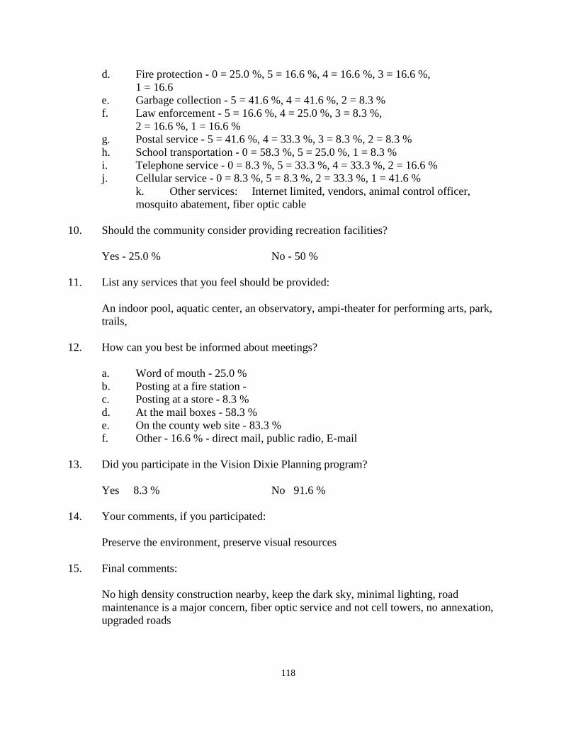
118
d. Fire protection - 0 = 25.0 %, 5 = 16.6 %, 4 = 16.6 %, 3 = 16.6 %, 1 = 16.6 e. Garbage collection - 5 = 41.6 %, 4 = 41.6 %, 2 = 8.3 % f. Law enforcement - 5 = 16.6 %, 4 = 25.0 %, 3 = 8.3 %, 2 = 16.6 %, 1 = 16.6 % g. Postal service - 5 = 41.6 %, 4 = 33.3 %, 3 = 8.3 %, 2 = 8.3 % h. School transportation - 0 = 58.3 %, 5 = 25.0 %, 1 = 8.3 % i. Telephone service - 0 = 8.3 %, 5 = 33.3 %, 4 = 33.3 %, 2 = 16.6 % j. Cellular service - 0 = 8.3 %, 5 = 8.3 %, 2 = 33.3 %, 1 = 41.6 % k. Other services: Internet limited, vendors, animal control officer,
mosquito abatement, fiber optic cable 10. Should the community consider providing recreation facilities? Yes - 25.0 % No - 50 % 11. List any services that you feel should be provided:
An indoor pool, aquatic center, an observatory, ampi-theater for performing arts, park, trails,
12. How can you best be informed about meetings? a. Word of mouth - 25.0 % b. Posting at a fire station - c. Posting at a store - 8.3 % d. At the mail boxes - 58.3 % e. On the county web site - 83.3 % f. Other - 16.6 % - direct mail, public radio, E-mail 13. Did you participate in the Vision Dixie Planning program? Yes 8.3 % No 91.6 % 14. Your comments, if you participated: Preserve the environment, preserve visual resources 15. Final comments:
No high density construction nearby, keep the dark sky, minimal lighting, road maintenance is a major concern, fiber optic service and not cell towers, no annexation, upgraded roads
119
WASHINGTON COUNTY COMMUNITY ANALYSIS FOR
THE COMMUNITY OF CLIFF DWELLERS GRASSY MEADOWS SKY RANCH, AND HURRICANE CLIFF ESTATES
2010 - 2011 In September of 2010 staff members of the County Planning Department met with citizens of the area of Cliff Dwellers / Grassy Meadows Sky Ranch / Hurricane Cliff Estates. Questionnaires were completed by those attending with others submitting a response to the county planning department over the internet Following is a summary of the questions and the comments that were responded to by those filling out the questionnaire. Residency and family size: The average resident of the Cliff Dweller / Grassy Meadow Sky Ranch / Hurricane Cliff Estates community has lived in the area for an average of almost 6 years. There were several long time residents participating, but also quite a few newcomers to the area. No one who filled out the questionnaire indicated a family size larger than two. This would indicate that the entire community would fall into the retirement category which is probably not completely correct. However, the questionnaire did not ask any questions relative to age. Whether or not most of those attending the meeting were retired is unknown. There were a number of reasons given for living in the area. The highest number of benefits mentioned were liking the open space and having a quiet community. These two categories each received 100 % of the answers to the question of why they liked the area. The fact that it is a safe community and the community is close to the mountains rated almost as high as the other two reasons given. Other reasons for liking the area included having a private airport, and an airport that was attached to their dwelling. The views around the area were mentioned, and the dark sky at night was also mentioned as an attraction to the area. Should the rural area be preserved? All of those responding to the questionnaire would like to preserve the rural atmosphere. Maintaining large lot sizes, buying land for non-development were given as ways to maintain the rural atmosphere. The county is not in a position to buy up land to prevent development. This has been suggested in other communities in the county. There are, however, various groups that do buy up development rights. This suggestion could be pursued by residents of the area as a possibility in preventing additional development. Limiting development, no commercial developments, don’t build, and do not annex, are recommendations that could happen, but of which the county is not involved. Only existing land owners could make those decisions.
120
Should farm land be preserved? Nearly all residents filling out the questionnaire were in favor of preserving farm land. On the other hand, there is no farm land in the community. In the case of this particular community, all agricultural land has been annexed to the City of Hurricane. Some of the suggestions for preserving the land are good suggestions but, in the case of this community, no longer have application. Incentives for farmers including green belt designations, and farmland protection designation can give protection to farmers. Co-op farming is a good idea if it can be implemented on existing, privately owned farmland. A suggestion was made to do away with the current elected county commission and planning commission. However, having no government in the area is not a viable solution to maintaining farm land. There is no place within this country were no government is acceptable. That suggestion relative to the area being under the jurisdiction of the county would suggest that perhaps the area should be annexed into the City of Hurricane rather than remaining as an unincorporated part of the county. Certainly, that is an option open to the residents of the community at any point of time that the majority of the residents petition the City of Hurricane for annexation. It is not a decision for the county to make. This suggestion has nothing to do with farmland. Walking and bicycle trails: Over 90% of the respondents were in favor of developing walking or bicycle trails in the community. Except for such things on existing roadways, such a system does not exist in the community. At such time as the vacant land in the community is proposed for development it would be a good time to recommend that a system of walking or bicycle trails is included in all new development. There is still more vacant land in the community than there is land that is currently developed. A good system of trails in the undeveloped land, as it develops, could be an asset to current as well as future residents of the area. Concerns about traffic safety, street and road conditions, unsafe OHV use, and street dedication: Of the above conditions, only one of these, road improvements, was rated at a high level of concern by residents. Speeding received some concern by residents and most of the other areas listed were rated relatively low levels of concern. Most of the concern about road improvements has to do with the condition of the roadway between Hurricane City, from south of the airport to Sky Ranch. That has been a problem for years and has received minimal improvement. The road is now a part of the City of Hurricane and all petitions for improvement of the road beyond the current condition would need to be submitted to Hurricane City. What should have happened and didn't, would have been to require the developer of Grassy Meadows Sky Ranch to improve the road into Hurricane inasmuch as the Sky Ranch development was essentially a "leap frog" development which should be discouraged in
121
community development. Because Hurricane City did not want to annex the development when it was proposed because it was so far from the improvements in the city, the county should have turned it down for the same reason until it became a natural expansion of Hurricane City. Because this was not done, and the county approved the subdivision, the condition of the connecting roadway has been a topic of concern since the subdivision was first approved. It will continue to be a problem until such time as development in the City of Hurricane extends along that roadway and meets up with the development near Sky Ranch. Should the proposed development adjacent to Sky Ranch, Cliff Dwellers, and Hurricane Cliff Estates again be pursued, the position of the residents of this development should be to oppose such development unless the road is improved as a condition of development to avoid additional "leap frog" development on the part of Hurricane City. The situation has not changed. Only the jurisdiction under which it will be developed is different. Desired commercial or industrial business: The majority of residents responding to the questionnaire would prefer that no commercial or industrial development take place in this area. The existing business and industrial areas of Hurricane City were the areas proposed for continued development. Public services: A number of public services in the valley were identified with a response as to concerns that may exist with the various services provided. There were no particularly high ratings. The highest rating was one of no concern relative to school bus transportation which simply indicates that most family's are not involved with school age children. Some ratings were in the 50 % range such as garbage collection and electric power. Lower ratings were given to fire protection, law enforcement, telephone and cell phone service, indicating that there is significant room for improvement in those areas of service. There were other public services that were mentioned with which some citizens were concerned. These included mosquito spraying, animal control, and obtaining fiber optic and cable services. Two of these issues would involve county participation. The others would involve private business which usually responds when it appears to be economically feasible to do so. Should the area provide recreation facilities? Half of the residents indicated that the area should not provide recreation services. A smaller proportion of residents felt that some recreational facilities would be useful. These included a desire for an indoor aquatic center, park, an outdoor theater for performing art programs in the area, and an astronomy observatory. How can you best be informed about public meetings? Placing information on the county web site was the most recommended source of information indicated by residents. This form of information is already being done. Other methods receiving
122
significant support included placing notice on the mail boxes, and to a lesser degree, by word of mouth. Other suggestions included public radio and direct mail which on a county wide basis is not economically feasible for use in the entire unincorporated area of the county. The Vision Dixie planning program of some years go was not participated in by most respondents to the questionnaire. Only a very small number of residents were involved. The comments from the participants included preservation of the natural and visual resources of the area which can be done in large measure because of the undeveloped public land in close proximity to the community. Final Comments: A few final comments were made to the questionnaire which included keeping the dark sky, having minimal lighting, fiber optic service instead of cellular towers, no annexation into Hurricane City, and road maintenance (which was discussed under public services above).
123
THE DAMMERON VALLEY COMMUNITY GENERAL PLAN
2010-2011 Introduction: Dammeron Valley is a part of the unincorporated area of Washington County. Residents and others should take time to review Section I of the county General Plan which discusses planning in general, the basis for planning, and the purpose of planning. Many of the things mentioned in the beginning of Section VII are also relevant to residents of this part of the county. The General Plan provides guidelines for the future of this particular part of the county in addition to those things that are applied county wide in the other sections of the General Plan. Dammeron Valley is among the more recent developments in the County and was never part of an area settled by the original pioneer settlers. The first phase of the Dammeron Valley community called the Dammeron Valley Ranches was recorded on May 17, 1976 and was the first phase of many in the valley which included other names such Damameron Valley Homesteads, Dammeron Valley Meadows, and some phases by other similar names. On January 23, 1990, a companion development was undertaken named Pinion Hills. Several phases of Pinion Hills have been recorded since that time. Pinion Hills is located on the hillside along the south side of the valley and goes nearly to the boundary of the Red Cliffs Wilderness area on the south. Altogether in both developments there are some 382 lots that have been platted and recorded since the beginning in 1976. Of these lots 255 have been recorded in the various Dammeron Valley subdivision plats, and 127 in the Pinion Hills Subdivisions. All of this development has taken place over the last 34 years. Prior to the development of either of the current subdivision developments, the area was more historically used for livestock grazing and a small amount of farming. Geography, Geology and Topography: Dammeron Valley is located on both sides of State Highway 18, just a few miles south of the unincorporated community of Veyo, and a few miles north of another unincorporated community called Diamond Valley. All three of these communities lie along Highway 18 connecting St. George City on the south and the City of Enterprise on the North. The Geology of the land in Dammeron Valley is very similar to the soil types found in Diamond Valley. These soil formations make up about 8 % of the soil types in Washington County as determined by a survey by the U.S. soil Conservation Service between the years of 1967 and 1971. Quoting from this soils study the soils in Dammeron Valley are generally identified as belonging to a group of soils called Napalene - Redbank - Schmutz - Palma association. Most of the soils
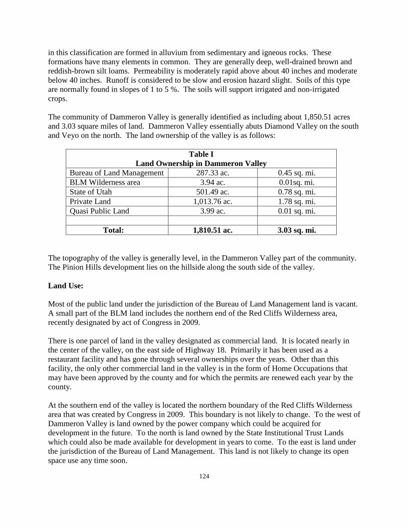
124
in this classification are formed in alluvium from sedimentary and igneous rocks. These formations have many elements in common. They are generally deep, well-drained brown and reddish-brown silt loams. Permeability is moderately rapid above about 40 inches and moderate below 40 inches. Runoff is considered to be slow and erosion hazard slight. Soils of this type are normally found in slopes of 1 to 5 %. The soils will support irrigated and non-irrigated crops. The community of Dammeron Valley is generally identified as including about 1,850.51 acres and 3.03 square miles of land. Dammeron Valley essentially abuts Diamond Valley on the south and Veyo on the north. The land ownership of the valley is as follows:
Table I Land Ownership in Dammeron Valley
Bureau of Land Management 287.33 ac. 0.45 sq. mi. BLM Wilderness area 3.94 ac. 0.01sq. mi. State of Utah 501.49 ac. 0.78 sq. mi. Private Land 1,013.76 ac. 1.78 sq. mi. Quasi Public Land 3.99 ac. 0.01 sq. mi.
Total: 1,810.51 ac. 3.03 sq. mi.
The topography of the valley is generally level, in the Dammeron Valley part of the community. The Pinion Hills development lies on the hillside along the south side of the valley. Land Use: Most of the public land under the jurisdiction of the Bureau of Land Management land is vacant. A small part of the BLM land includes the northern end of the Red Cliffs Wilderness area, recently designated by act of Congress in 2009. There is one parcel of land in the valley designated as commercial land. It is located nearly in the center of the valley, on the east side of Highway 18. Primarily it has been used as a restaurant facility and has gone through several ownerships over the years. Other than this facility, the only other commercial land in the valley is in the form of Home Occupations that may have been approved by the county and for which the permits are renewed each year by the county. At the southern end of the valley is located the northern boundary of the Red Cliffs Wilderness area that was created by Congress in 2009. This boundary is not likely to change. To the west of Dammeron Valley is land owned by the power company which could be acquired for development in the future. To the north is land owned by the State Institutional Trust Lands which could also be made available for development in years to come. To the east is land under the jurisdiction of the Bureau of Land Management. This land is not likely to change its open space use any time soon.
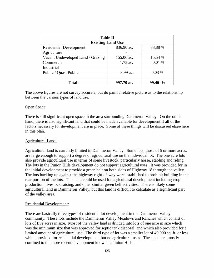
125
Table II Existing Land Use
Residential Development 836.90 ac. 83.88 % Agriculture - Vacant Undeveloped Land / Grazing 155.06 ac. 15.54 % Commercial 1.75 ac. 0.01 % Industrial - Public / Quasi Public 3.99 ac. 0.03 %
Total: 997.70 ac. 99.46 %
The above figures are not survey accurate, but do paint a relative picture as to the relationship between the various types of land use. Open Space: There is still significant open space in the area surrounding Dammeron Valley. On the other hand, there is also significant land that could be made available for development if all of the factors necessary for development are in place. Some of these things will be discussed elsewhere in this plan. Agricultural Land: Agricultural land is currently limited in Dammeron Valley. Some lots, those of 5 or more acres, are large enough to support a degree of agricultural use on the individual lot. The one acre lots also provide agricultural use in terms of some livestock, particularly horse, stabling and riding. The lots in the Pinion Hills development do not support agricultural uses. It was provided for in the initial development to provide a green belt on both sides of Highway 18 through the valley. The lots backing up against the highway right-of-way were established to prohibit building in the rear portion of the lots. This land could be used for agricultural development including crop production, livestock raising, and other similar green belt activities. There is likely some agricultural land in Dammeron Valley, but this land is difficult to calculate as a significant part of the valley area. Residential Development: There are basically three types of residential lot development in the Dammeron Valley community. These lots include the Dammeron Valley Meadows and Ranches which consist of lots of five acres in size. Most of the valley land is divided into lots of one acre in size which was the minimum size that was approved for septic tank disposal, and which also provided for a limited amount of agricultural use. The third type of lot was a smaller lot of 40,000 sq. ft. or less which provided for residential development, but no agricultural uses. These lots are mostly confined to the more recent development known as Pinion Hills.
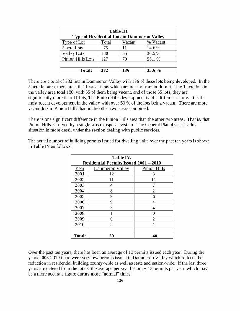
126
Table III Type of Residential Lots in Dammeron Valley
Type of Lot Total Vacant % Vacant 5 acre Lots 75 11 14.6 % Valley Lots 180 55 30.5 % Pinion Hills Lots 127 70 55.1 % Total: 382 136 35.6 %
There are a total of 382 lots in Dammeron Valley with 136 of these lots being developed. In the 5 acre lot area, there are still 11 vacant lots which are not far from build-out. The 1 acre lots in the valley area total 180, with 55 of them being vacant, and of those 55 lots, they are significantly more than 11 lots, The Pinion Hills development is of a different nature. It is the most recent development in the valley with over 50 % of the lots being vacant. There are more vacant lots in Pinion Hills than in the other two areas combined. There is one significant difference in the Pinion Hills area than the other two areas. That is, that Pinion Hills is served by a single waste disposal system. The General Plan discusses this situation in more detail under the section dealing with public services. The actual number of building permits issued for dwelling units over the past ten years is shown in Table IV as follows:
Table IV. Residential Permits Issued 2001 – 2010
Year Dammeron Valley Pinion Hills 2001 12 3 2002 11 11 2003 4 7 2004 8 2 2005 9 6 2006 9 4 2007 3 4 2008 1 0 2009 0 2 2010 2 1
Total: 59 40
Over the past ten years, there has been an average of 10 permits issued each year. During the years 2008-2010 there were very few permits issued in Dammeron Valley which reflects the reduction in residential building county-wide as well as state and nation-wide. If the last three years are deleted from the totals, the average per year becomes 13 permits per year, which may be a more accurate figure during more “normal” times.
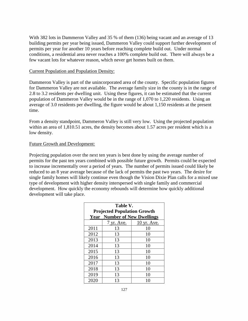
127
With 382 lots in Dammeron Valley and 35 % of them (136) being vacant and an average of 13 building permits per year being issued, Dammeron Valley could support further development of permits per year for another 10 years before reaching complete build out. Under normal conditions, a residential area never reaches a 100% complete build out. There will always be a few vacant lots for whatever reason, which never get homes built on them. Current Population and Population Density: Dammeron Valley is part of the unincorporated area of the county. Specific population figures for Dammeron Valley are not available. The average family size in the county is in the range of 2.8 to 3.2 residents per dwelling unit. Using these figures, it can be estimated that the current population of Dammeron Valley would be in the range of 1,070 to 1,220 residents. Using an average of 3.0 residents per dwelling, the figure would be about 1,150 residents at the present time. From a density standpoint, Dammeron Valley is still very low. Using the projected population within an area of 1,810.51 acres, the density becomes about 1.57 acres per resident which is a low density. Future Growth and Development: Projecting population over the next ten years is best done by using the average number of permits for the past ten years combined with possible future growth. Permits could be expected to increase incrementally over a period of years. The number of permits issued could likely be reduced to an 8 year average because of the lack of permits the past two years. The desire for single family homes will likely continue even though the Vision Dixie Plan calls for a mixed use type of development with higher density interspersed with single family and commercial development. How quickly the economy rebounds will determine how quickly additional development will take place.
Table V. Projected Population Growth
Year Number of New Dwellings 7 yr. Ave. 10 yr. Ave. 2011 13 10 2012 13 10 2013 13 10 2014 13 10 2015 13 10 2016 13 10 2017 13 10 2018 13 10 2019 13 10 2020 13 10
128
Using the 7 year average, 130 permits would be issued in the next 10 years and 100 permits would be issued using the entire 10 year average. In terms of actual numbers of residents, using the 7 year average the population could increase by about 400 new residents. Using the 10 year average, the projected increase would be about 300 to 400 new residents. The above calculations, in simple terms, represent the current and future populations of the Dammeron Valley area. The General Plan supports those calculations and projections. However, in the case of Dammeron Valley, things are not that simple. Lying essentially to the west of the current Dammeron Valley are three blocks of land, each of which have potential for development. One is owned by the Utah State and Institutional Trust Lands. These lands were intended by Congress at the time of Utah Statehood, to provide land for the future support of the State School System. The land was intended to be sold over time with the income from the sale to be placed in a trust, the income of which would ensure to the schools of the state. Another block of land immediately adjacent to Dammeron Valley is property owned by Rocky Mountain Power Company. It runs westward from Dammeron Valley to the edge of Gunlock and contains both the upper and lower sand cove reservoirs. Adjacent to the power company property is another block of land under the jurisdiction of the Bureau of Land Management. The 1990 BLM Resource Management Plan identified this block of BLM land for future disposal purposes. The 2009 Land Bill, approved by Congress and the President, also identified this parcel of land as being one that would be disposed of by the BLM. There are no dates identified by which any of these blocks of land should be disposed of or traded for development. Under the current economic situation, it is not likely than any of them will change in the foreseeable future. In combination these blocks of land total some 4,500 to 5,000 acres of land. Such a development would reach from State Highway 18 westward to the community of Gunlock. Therefore the General Plan must bring this possibility to the attention of the residents of the community of Dammeron Valley. Assuming that utility services, primarily water, could be developed, there is really nothing that would prohibit development if it is requested at some future time. Because Dammeron Valley is unincorporated, and is not adjacent to any incorporated city or town, the decision relative to the future essentially lies in the hands of the residents of Dammeron Valley as to whether it should incorporate, or should continue to be an unincorporated part of Washington County. The General Plan has always taken the position that self determination is preferable to other forms of government, and that the government closest to the people is the best possible form of government. Neither the General Plan nor the county has authority to require incorporation. The decision as to whether or not to incorporate would need to be made by the residents of Dammeron Valley. The only purpose of the General Plan is to make the residents of the valley aware of the possible potentials that could take place at a future
129
time so that the residents can weigh these considerations into any decision as to the future of Dammeron Valley. Vision Dixie Principle Summary: Along with recommendations for residential growth and future development in Dammeron Valley, along with other types of development such as commercial growth, the Vision Dixie Project, which was sponsored by Washington County a few years ago, and which was adopted by the county upon its completion, makes recommendations for many other phases of community development. A summary of the Vision Dixie Principles and their relationship to Dammeron Valley is shown as follows: 1. Plan regionally, implement locally - The General Plan for Dammeron Valley is a local
plan for the residents of Dammeron Valley, It is however, intended to be adopted as a part of the Washington County General Plan.
2. Maintain air and water quality, and conserve water - Air and water quality is very
important to residents of Dammeron Valley. Many people live in communities such as Dammeron Valley because of the clean air that exists. Conservation is also evident here because of the limited outdoor watering of lawn areas. There are trees in Dammeron Valley, however much of the landscaping is of a natural variety that does not require additional water.
3. Guard our signature landscapes - See the section of the plan dealing with open space
development. There is surrounding land surrounding Dammeron Valley, much of which will not be used for development purposes.
4. Provide rich connected natural recreation areas and open spaces - There is no shortage of
natural open space recreation areas surrounding Dammeron Valley. The Pine Valley Mountain is not far away on the east. The Red Cliffs Wilderness area is almost adjacent on the south.
5. Build a balanced transportation system - The County has developed a county-wide
transportation plan. See Section III of the General Plan for further information on the county transportation plan. As far as such things as a commuter bus system connecting Dammeron Valley with the St. George City valley, that service is still many years in the future, but could become a reality at a future time. It is possible that a bus system could operate between St. George City and Enterprise City at some future time with stops along the way in each of the communities along State Highway 18.
6. Get centered by focusing on growth in walkable mixed use centers - In a community
such as Dammeron Valley that was essentially developed prior to the Vision Dixie Plan being developed, it is difficult to retrofit the community into a mixed use center now that it has been almost fully completed. On the other hand, Dammeron Valley is compact enough that it could be considered to be generally walkable as it is currently developed. It is not a mixed use community in the true sense of mixed use, although the single family
130
homes do provide a mixture of lot sizes and uses within the community. It would be difficult at this time to identify areas for true mixed uses to be developed. Unless a sewage disposal system was installed for the entire community, it would be difficult to develop lots of a mixed use nature using septic tanks as a means of waste disposal.
7. Direct growth inward - Dammeron Valley has been developed as a relative compact
subdivision insofar as various sized of single family lots and homes are concerned. The valley, as well as all of the other unincorporated areas has not been able to support a higher or mixed use density using septic tanks. Sewer systems have not been available in the county with the exception of the Pinion Hills project which has been served by a large septic tank and by an on-site treatment facility at some time in the near future.
8. Provide a broad range of housing types - This element has been discussed previously. As
far as the unincorporated communities of the county are concerned, Dammeron Valley provides a greater variety of housing types than any other of the unincorporated communities. The Vision Dixie Plan suggests a broader variety of mixed uses and multiple family dwelling units which are not possible in this valley without a sewage disposal system.
9. Reserve areas for industry - This is discussed in the following section dealing with
industrial development. 10. Public land conversion - No conversion of public land is needed for the build out of the
community. However, as discussed in this Plan, there are potentials for future development in Dammeron Valley which would include much additional land being added to the valley, some of which has been identified for disposal by the BLM for future development. In an area of new development, the principles of the Vision Dixie Plan could be incorporated into community planning from the very beginning.
Commercial Development: Commercial development is mostly non-existent in Dammeron Valley except for one commercial business located adjacent to State High 18. There are also some home occupations in the valley which can be expected to expand in future years. In some communities both incorporated cities and unincorporated communities. Home occupations make up a significant element in those areas. The General Plan would suggest that it may be possible for other commercial business to locate in the Dammeron Valley area to provide additional commercial facilities beyond the current business. The General Plan suggests that it would not be prudent for Dammeron Valley to try to bring in businesses along the State Highway to attract consumers to stop in the valley to shop for commercial services. It would be within the range of possibility for commercial business to develop in the Dammeron Valley area to support the needs of the residents of the community. It is difficult to attract industrial or manufacturing business to an area without ready access to an interstate freeway. State Highway 18 is a major highway, and as such can support a significant amount of traffic. Further, it should be widened to at least four lanes all the way between
131
St.George City and the community of Central as quickly as possible. However, with all of the potential for development of additional land in the Dammeron Valley area, only that land adjacent to the State Highway would have any significant industrial potential. If it did develop with an industrial base, it is still a significant distance to the Interstate 15 Freeway. For these reasons, the General Plan does not project any significant industrial development in the Dammeron Valley area during the time of this Plan. Public Services: A section of the General Plan relative to public services in the county is contained at the beginning of this section of the plan, Section VII. Many comments are re-stated here as they specifically apply to the community of Dammeron Valley. Electricity: Electric service in Dammeron Valley is provided by the Rocky Mountain Power Company. A few years ago a new sub-station was constructed at the south end of the valley, about mid-way between Diamond Valley and Dammeron Valley. With the completion of this sub-station, the power company is better able to serve this area of the county. The same power company is planning an expansion of their service capacity between the major power hub at Sigurd, Utah, and the sub-station located at Central / Dixie Deer Estates. This expansion with another service line is expected too be complete in about 3 to 4 years. This will provide good service to the Dammeron Valley area for many years into the future. During the county input meeting, comments were made relative to contact with the power company relative to identifying ORV and other trails within the power company property. The General Plan would support continued dialogue with the residents of Dammeron Valley relative to providing access to and through the power company property. Natural Gas: A number of years ago, the Questar Gas Company installed a natural gas line from a point near the town of Central, running parallel State Highway 18 southward toward the City of St. George. The installation of this line made natural gas service available to communities along the way, including Veyo, Dammeron Valley, Diamond Valley and Winchester Hills. This line connects with the other major supply line serving the St. George valley from the east, giving service to most of the county from either direction. This supply of natural gas should be sufficient to serve all of the communities currently connected to the system for both current demand and for future growth. Water: Water in Dammeron Valley is provided by the Dammeron Valley Water Company. This is a privately owned company under the ownership of the developer of Dammeron Valley. It appears that this system is sufficient to serve the community of Dammeron Valley through the period of the General Plan. It would not be sufficient to provide culinary water to the other blocks of land
132
adjacent to Dammeron Valley that could, at some time in the future, be proposed for development. It is possible that the Washington County Water Conservancy District would be able to provide supplementary water to the valley at some future time, should it be necessary to obtain supplementary water for the existing community, or to supply water for additional land in the Dammeron Valley area. Sewage Disposal: Presently, liquid waste is disposed of through two separate methods. All of the Dammeron Valley area is served by individual septic tanks. This system has seemed to serve the valley well up to this point. In order to maintain the septic system as a healthy means of disposal, the valley should consider a program of septic tank maintenance in which home owners pay a maintenance fee just as a homeowner on a sewage system would pay. This would provide for an annual inspection of each system in the community, with those needing pumping or other improvements, these improvements would be made at no further cost to the home owner. In so doing, septic tanks could be a satisfactory method of disposal for years to come. The Pinion Hills portion of Dammeron Valley is presently connected by outfall lines leading to a large septic tank and drain field system. This system has worked generally well since its inception. At some agreed upon time, the developer is bonded to provide an on-site disposal system to take care of the entire Pinion Hills system. This plan will work well, and will provide service to the Pinion Hills area for the period of the General Plan. An alternative to an on-site system would be to extend an outfall line from Dammeron Valley to the existing sewer system currently extended to the Ledges development in St. George City. This outfall line extension may be less expensive than the installation of a package plant. It would particularly make sense if the community of Diamond Valley also precipitated in the outfall line extension. Washington County recently made an agreement with the Washington County Water Conservancy District to oversee waste services to all of the western part of the county. Any new development in western Washington County will be required to meet the requirements that may be established by the Water Conservancy District. Roads: Road maintenance of the roads in Dammeron Valley now comes from the Washington County Road Department. Most of the roads in the valley have been dedicated to the county through the subdivision process. Most of the roads in the valley portion of the community are, or have been, graveled while the roads in Pinion Hills have been paved via changes in county ordinance requiring paved roads in subdivisions as opposed to gravel roads which were required many years ago. In unincorporated county areas, the roads are classified by the State as “Class B” roads. Depending upon the degree of improvement, the county receives funds from the State for maintenance purposes. This amount is subject to change from one year to another with the funds
133
for maintenance coming from the Gasoline Tax applied to all gasoline purchased throughout the country. Dirt roads receive the least amount of funding; paved roads receive the most maintenance money. In Washington County, roads have historically been maintained with the money received from the State gas tax fund. Property Tax funds have not been used for road maintenance. It has long been the county policy to maintain roads in essentially the condition in which they were created. If the property owners in Dammeron Valley want to have their roads maintained at a higher standard, the position of the county would be that when the owners of an area bring their roads up to that higher level, the county will then maintain them at the new standard. This is sometimes done through an improvement district that spreads the cost of improvement over a period of usually not more than ten years, instead of a one-time payment up front from the property owners. Fire Protection: Fire protection in Dammeron Valley is provided by the Dammeron Valley Fire Department. This fire department works under the umbrella of the Dammeron Valley Landowners Association. It is essentially a “stand alone” fire department and is not tied to either the Northwest, or the Southwest District Fire Departments that serve areas both to the north and south of Dammeron Valley. The fire chief participates in the county fires chief’s association, and does participate in training programs available on a county wide basis. There is a fire station located in Dammeron Valley, and the fire department is a volunteer fire department. They do have significant equipment available for use by the firemen, and the department would appear to be adequate for the community as it currently exists, including Pinion Hills, assuming that there is no significant development outside of the currently platted and recorded development. Should the valley experience extensive expansion, the issue of fire protection could be revisited at that time. Public Safety: Police protection is provided by the Washington County Sheriff’s Office. This service will continue as long as Dammeron Valley continues as an unincorporated part of Washington County. This method of police protection would continue even if Dammeron Valley was incorporated until such time as the town created their own law enforcement department. Some communities have contracted with the county for an increased visibility of sheriff’s officers through a contract with the county calling for more sheriffs’ visibility in their community through a specific contract calling for more sheriffs’ protection in exchange for additional funds being raised by the community. Solid Waste: A solid waste board, made up of one representative from each city or town in the county, along with one member of the county, oversee the collection of solid waste in the county. This board contracts with a private company to provide the collection of waste in the county. There is a
134
central land fill location which is owned by the county and managed by the solid waste company. That site is expected to be sufficient for many years to come. This system of management and oversight is also expected to continue, and appears to be adequate to serve the valley. Building Inspection: Building inspection of new construction in Dammeron Valley is provided by the county building department. The cost of a permit in the county is approximately $2,000.00 for an “average” home. The cost of a permit is established in order to pay for the cost of the service provided, and is intended to be subsidized by residents of the county in general. The county has no impact fees outside of the fee for the preservation of the Desert Tortoise, which fee is collected county wide. Some incorporated communities in the county also contract with the county to provide building inspection services. Communication: Most of Washington County is served by the CenturyLink communication company. In addition to CenturyLink services there are a number of private cellular companies providing service within the county. Except for the possibility of a cellular tower somewhere in the Dammeron Valley area, it would appear that communication services are sufficient for the present time. There are some communication services through cable television and computer companies and from satellite communications. Flood Control: Flood control has not been a major problem in Dammeron Valley compared to some of the other unincorporated communities in the county. During heavy storms there have been time when the culverts under the state highway have not been sufficient to carry the runoff, but overall, Dammeron Valley has gotten by comparatively well. Annexation / Incorporation: There have been comments, from time to time, from the Dammeron Valley area relative to consideration to incorporate as a stand alone community in the county. This issue was discussed by the General Plan in the previous section dealing with residential development. The General Plan would simply suggest that of all of the unincorporated communities in the county, Dammeron Valley may have more to gain through incorporation because of the great potential for development adjacent to the community. If all of that land remains in the county, there is no reason for the county to give special direction to the development of these areas other than through current county ordinances. Dammeron Valley could establish specific development criteria that would allow development to take place, but under the direction of the current community. The county would support incorporation of Dammeron Valley. The General Plan currently being proposed, would constitute a significant part of a feasibility study, currently required by State law prior to an annexation being considered, without another
135
extensive study being required for the same purpose. To incorporate or not to incorporate is a local decision, and the county will continue to support each area of the county as an unincorporated part of the county.
WASHINGTON COUNTY COMMUNITY STATISTICAL SURVEY
FOR THE COMMUNITY OF DAMMERON VALLEY 2010-2011 1. Residency status a. How long have you lived as this location? 8 year average b. Number in family 3 average c. Home Owner 100 % d. Land owner 100 % 3.25 acres average 2. Please mark characteristics that you value the most or that help you choose to live or own
property in this area. a. Born or raised in the area 22.2 % b. Close to family, friends, or neighbors 22.2 % c. Close to mountains 77.7 %
d. Like the open space 88.8 % e. The opportunity to keep horses, animals, etc. 77.7 % f. Quiet community 77.7 % g. Recreational opportunities 88.8 % h. Safe environment 100.0 % i. Small town atmosphere 100.0 % j. Other: There are four seasons here 3. Should the rural atmosphere be preserved? a. Yes 100 % No 0 b. If yes, how should it be done? Keep homes on large acreage, maintain
CC&R’s, no 1/4 acre lots in 1 acre area, limit density and land use, manage growth, it is already being done.
c. Should existing farm land be preserved? Yes 88.8 % No 22.2 % d. How should it be done? Tax breaks, water cost incentives, require more open
space in developments, the land is privately owned leave it alone. 4. Would you favor developing a system of walking/bicycle trails throughout the
community? Yes 55.5 % No 44.4 % 5. Please mark on a scale of 1 - 5 your concerns on each of the following: Traffic, safety,
street and road conditions, unsafe ORV use, street dedication.
136
a. Off-highway vehicles on streets - 0 = 44.4 %, 2= 22.2 %, 5 = 33.3 % b. Speed/traffic control - 0 = 1 = 11.1 %, 3 = 33.3 %, 4 = 22.2 %, 5 = 33.3 % c. Road conditions - 0 = 11.1 %, 2 = 11.1 %, 3 = 22.2 %, 4 = 33.3 %, 5 = 22.2 % d. Unsafe ORV use - 0 = 44.4 %, 5 = 55.5 % e. Street dedication - 0 = 44.4 %, 4 = 11.1 %, 5 = 11.1 % 6. Desired commercial or industrial business? Yes 22.2 % No 44.4 % What types of commercial would be desirable? Restaurant, feed store, storage units, 7. Where should it be located? Near the substation south of the valley, in St. George 8. Rate your experience with the following local services as they relate to your area. Excellent = 5, Poor = 1, No experience = 0. a. Ambulance / medical - 0 = 44.4 %, 3 = 11.1 %, 4 = 11.1 %, 5 = 22.2 % b. Water service & quality - 1 = 11.1 %, 3 = 33.3 %, 4 = 11.1 %, 5 = 44.4 % c. Electrical power service - 2 = 22.2 %, 3 = 33.3 %, 4 = 11.1 %, 5 = 33.3 % d. Fire Protection - 0 = 22.2 %, 4 = 33.3 %, 5 = 44.4 % e. Garbage Service - 4 = 22.2 %, 5 = 77.7 % f. Law Enforcement - 0 = 33.3 %, 3 = 11.1 %, 4 = 33.3 %, 5 = 22.2 % g. Postal Service - 3 = 22.2 %, 4 = 11.1 %, 5 = 66.6 % h. School Transportation - 0 = 33.3 %, 4 = 33.3 %, 5 = 22.2 %. i. Telephone Service - 1 = 22.2 %, 2 = 11.1 %, 3 = 33.3 %, 4 = 22.2 %, 5 = 11.1 %. j. Cell Phone Service - 1 = 44.4 %, 2 = 33.3 %, 3 = 11.1 %, 5 = 11.1 % k. Other - Natural Gas - 4 = 11.1 % 9. Should the community provide recreation facilities for residents of the community? Yes 11.1 % No 66.6 % 10. If answer is yes, list desirable facilities: Hiking trails, ATV trails 11. How can you best be informed about meetings, times, agendas, events, issues, etc? a. Word of mouth - 44.4 % b. Mail boxes - 99.9 % c. Fire Station - 66.6 % d. Posting on the internet - 88.8 % e. Other - Store - 11.1 %, Home Owners - 11.1 % 12. Did you participate in the Vision Dixie program? Yes 33.3 % No 77.7 % What did you like most about it? It was a good presentation.
137
WASHINGTON COUNTY COMMUNITY SURVEY ANALYSIS
FOR THE COMMUNITY OF DAMMERON VALLEY
2010-2011
On July 27, 2010, members of the Washington County Planning Department met with residents of the community of Dammeron Valley at the Dammeron Valley fire station. The group was small, but those present entered into a discussion of the Dammeron Valley community. Questionnaires were completed by those present with others able to submit the same information over the internet or to fill out the form and submit them to the county planning office. Following is a summary of the questions asked, and the comments that were responded to by those present along with other comments submitted to the planning office The length of time that residents have lived in the community was 8 years, and the average family size reported was 3. Many reasons were given for living in Dammeron Valley. These reasons included being born or raised there; close to family, friends or neighbors. Because Dammeron Valley has not been in existence for that many years, more reasons for living there included such things as being close to the mountains and parks; the open space; it being a quiet community; the opportunities for recreation; a safe environment, and all respondents favored the safe environment and the small town atmosphere. One resident was attracted by the four seasons that exist in the valley. All residents agreed that the small town atmosphere should be maintained. As to how to do this, such things as keeping homes on large lots, maintenance and enforcement of the CC&R’s; and by managing growth. Most respondents also would like to maintain the agricultural use of land in the area. To do so, it was suggested that tax breaks be enacted; water cost incentives should be offered to agriculture; more open space should be required in developments; or, because it is private land, it should be left alone. There seems to be an interest in developing walking and bicycle trails in Dammeron Valley, although the comments submitted also showed a strong feeling that these things are not necessary or desirable. The respondents were quite evenly divided on this issue. . A few respondents considered off-highway vehicles on the streets to be a problem. Most did not. However, most had a significant concern relative to traffic control and speed on the streets of Dammeron Valley. Road conditions seemed to be mostly acceptable, with a few respondents indicating that further improvement would be desirable. Relative to the unsafe use of ORV units in Dammeron Valley about half of the respondents had no opinion, and the other one-half felt that there was a significant problem. Perhaps more education of users, especially under-age riders might be necessary.
138
A majority of those in Dammeron Valley are not supportive to commercial development in Dammeron Valley. Among those that favored commercial development, such things as restaurants, a feed store, and storage units were suggested. However, even among those wanting some commercial development, the logical location was somewhere south of the valley near the electrical substation or even further south, in the City of St. George. There are a number of local public services that are provided in Dammeron Valley. These include such things as ambulance service wherein about half of the respondents indicated having no experience with ambulance service. This may indicate a healthy population not needing this service. Among those seeing a need, or having had experience, most felt that the service was reasonably good. The provision of culinary water was rated very high suggesting a well run water system. Electrical service generally rated quite high, and fire protection was generally good. Among the best rating was garbage collection with law enforcement also getting generally high marks. The service of the Post Office also rated very high, indicating that residents are mostly satisfied with the service of the Post Office. Many residents were unfamiliar with the provision of school transportation, indicating that many of the residents do not have children of school age. Among others, transportation to schools was rated good to excellent with no poor ratings. Telephone service appeared to receive an “adequate” rating, but cell phone service would indicate that perhaps additional cell phone service would be beneficial. Either a resident has a service that works in the valley, or it does not. Overall, improvement in this area seems to be desirable. In terms of being informed of meetings, public notices, etc., a notice posted near the mail boxes received the highest rating. The use of the internet also rated high, followed by notice at the fire station, followed by work of mouth from one resident to another. A few years ago, the county sponsored a planning effort titled “The Vision Dixie” program. As far as respondents were concerned, most did not participate in this planning effort, with only a few indicating that they had been involved. More will be said about this program as a part of the body of the General Plan that is the major part of this questionnaire process.
139
The Diamond Valley Community General Plan 2010 -2011
Background and History: Unlike many settlements in Washington County, the Diamond Valley area does not have a historical pioneer heritage. The community is not mentioned in any history books on the subject of Washington County. The private property in Diamond Valley has been owned by a number of owners over the years, and it appears to have been used primarily for ranching and livestock grazing. In the late 1950's, Arlen D. Moore began purchasing property in the Diamond Valley area, and consolidating much of the landownership in the valley. Mr. Moore was responsible for the construction of a ranch house in the northern end of the valley. He also constructed livestock stables, a bunk house, a pond, and developed much of the original water supply that now serves the community. In the early to mid 1970's a group of local investors joined together in purchasing the Moore property and created an organization known as Diamond Valley Ranches, Inc. This started the development of Diamond Valley, and the beginning of what has come to be known today as the Diamond Valley community. Over the years, Diamond Valley has developed into a quiet, attractive community not fronting along State Highway 18, but rather developed into a quiet, attractive community located off the highway, and nestled in the valley that was originally the Moore Ranch. The developmental history of the valley therefore dates back about twenty-five to thirty years, making it one of the more recent developments in Washington County. Geography, Geology, and Topography: Geographically, Diamond Valley lies about midway between the "historic" boundary of the City of St. George, and the unincorporated town of Veyo. About the same time as the development of Diamond Valley was taking place, other developments were springing up along State Highway 18, including the communities of Winchester Hills, Dammeron Valley, and its companion development of Pinion Hills. Diamond Valley is reached via State Highway 18 between St. George and Enterprise which is located at the north end of the county. The topography of the valley generally slopes from north to south, and is surrounded by relatively low hills sloping toward the Pine Valley Mountains. The valley itself slopes generally toward the south and was, at one time self contained. This means that it was a closed valley with no outlet at the south end of the valley, in effect creating a "dry lake" in times of storm runoff. The closed valley has since been breached to allow water to escape from the valley into the lava rocks at the southern end. Flooding in the valley is still a problem in some areas of the community and this issue needs to be brought to a conclusion.
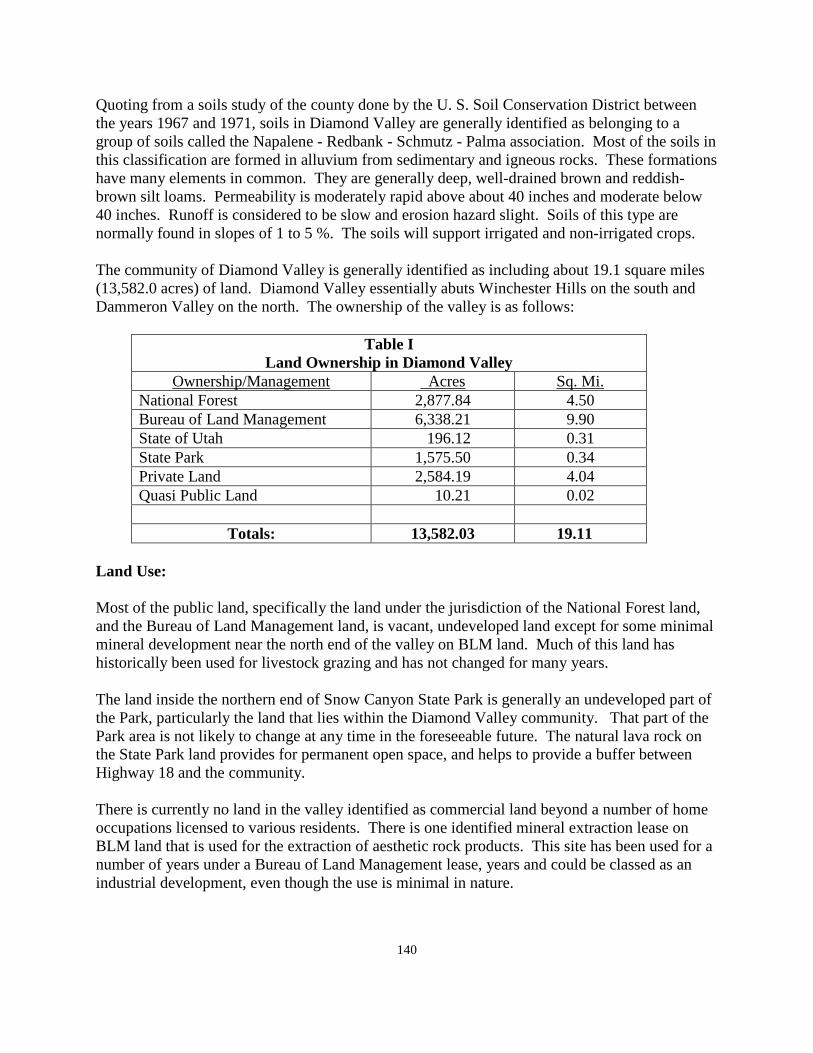
140
Quoting from a soils study of the county done by the U. S. Soil Conservation District between the years 1967 and 1971, soils in Diamond Valley are generally identified as belonging to a group of soils called the Napalene - Redbank - Schmutz - Palma association. Most of the soils in this classification are formed in alluvium from sedimentary and igneous rocks. These formations have many elements in common. They are generally deep, well-drained brown and reddish-brown silt loams. Permeability is moderately rapid above about 40 inches and moderate below 40 inches. Runoff is considered to be slow and erosion hazard slight. Soils of this type are normally found in slopes of 1 to 5 %. The soils will support irrigated and non-irrigated crops. The community of Diamond Valley is generally identified as including about 19.1 square miles (13,582.0 acres) of land. Diamond Valley essentially abuts Winchester Hills on the south and Dammeron Valley on the north. The ownership of the valley is as follows:
Table I Land Ownership in Diamond Valley
Ownership/Management Acres Sq. Mi. National Forest 2,877.84 4.50 Bureau of Land Management 6,338.21 9.90 State of Utah 196.12 0.31 State Park 1,575.50 0.34 Private Land 2,584.19 4.04 Quasi Public Land 10.21 0.02
Totals: 13,582.03 19.11
Land Use: Most of the public land, specifically the land under the jurisdiction of the National Forest land, and the Bureau of Land Management land, is vacant, undeveloped land except for some minimal mineral development near the north end of the valley on BLM land. Much of this land has historically been used for livestock grazing and has not changed for many years. The land inside the northern end of Snow Canyon State Park is generally an undeveloped part of the Park, particularly the land that lies within the Diamond Valley community. That part of the Park area is not likely to change at any time in the foreseeable future. The natural lava rock on the State Park land provides for permanent open space, and helps to provide a buffer between Highway 18 and the community. There is currently no land in the valley identified as commercial land beyond a number of home occupations licensed to various residents. There is one identified mineral extraction lease on BLM land that is used for the extraction of aesthetic rock products. This site has been used for a number of years under a Bureau of Land Management lease, years and could be classed as an industrial development, even though the use is minimal in nature.
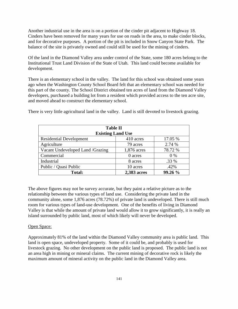
141
Another industrial use in the area is on a portion of the cinder pit adjacent to Highway 18. Cinders have been removed for many years for use on roads in the area, to make cinder blocks, and for decorative purposes. A portion of the pit is included in Snow Canyon State Park. The balance of the site is privately owned and could still be used for the mining of cinders. Of the land in the Diamond Valley area under control of the State, some 180 acres belong to the Institutional Trust Land Division of the State of Utah. This land could become available for development. There is an elementary school in the valley. The land for this school was obtained some years ago when the Washington County School Board felt that an elementary school was needed for this part of the county. The School District obtained ten acres of land from the Diamond Valley developers, purchased a building lot from a resident which provided access to the ten acre site, and moved ahead to construct the elementary school. There is very little agricultural land in the valley. Land is still devoted to livestock grazing.
Table II Existing Land Use
Residential Development 410 acres 17.05 % Agriculture 79 acres 2.74 % Vacant Undeveloped Land /Grazing 1,876 acres 78.72 % Commercial 0 acres 0 % Industrial 8 acres .33 % Public / Quasi Public 10 acres .42%
Total: 2,383 acres 99.26 % The above figures may not be survey accurate, but they paint a relative picture as to the relationship between the various types of land use. Considering the private land in the community alone, some 1,876 acres (78.72%) of private land is undeveloped. There is still much room for various types of land-use development. One of the benefits of living in Diamond Valley is that while the amount of private land would allow it to grow significantly, it is really an island surrounded by public land, most of which likely will never be developed. Open Space: Approximately 81% of the land within the Diamond Valley community area is public land. This land is open space, undeveloped property. Some of it could be, and probably is used for livestock grazing. No other development on the public land is proposed. The public land is not an area high in mining or mineral claims. The current mining of decorative rock is likely the maximum amount of mineral activity on the public land in the Diamond Valley area.
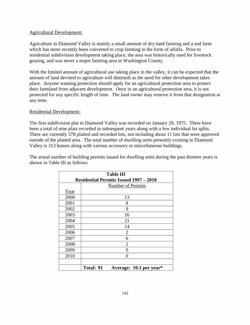
142
Agricultural Development: Agriculture in Diamond Valley is mainly a small amount of dry-land farming and a sod farm which has more recently been converted to crop farming in the form of alfalfa. Prior to residential subdivision development taking place, the area was historically used for livestock grazing, and was never a major farming area in Washington County. With the limited amount of agricultural use taking place in the valley, it can be expected that the amount of land devoted to agriculture will diminish as the need for other development takes place. Anyone wanting protection should apply for an agricultural protection area to protect their farmland from adjacent development. Once in an agricultural protection area, it is not protected for any specific length of time. The land owner may remove it from that designation at any time. Residential Development: The first subdivision plat in Diamond Valley was recorded on January 29, 1975. There have been a total of nine plats recorded in subsequent years along with a few individual lot splits. There are currently 378 platted and recorded lots, not including about 11 lots that were approved outside of the platted area. The total number of dwelling units presently existing in Diamond Valley is 313 homes along with various accessory or miscellaneous buildings. The actual number of building permits issued for dwelling units during the past thirteen years is shown in Table III as follows:
Table III Residential Permits Issued 1997 – 2010
Year
Number of Permits
2000 13 2001 8 2002 9 2003 16 2004 21 2005 14 2006 2 2007 6 2008 2 2009 0 2010 0
Total: 91 Average: 10.1 per year*
143
* Over the past decade there has been an average of 10.1 permits issued each year. This does not include the years 2009-2010 when no permits were issued because of the decline in the economy. Theoretically, with 378 subdivision lots and 300 homes in platted subdivisions, Diamond Valley could reach "build out" in about six more years. Realistically, that scenario will not happen. Currently, according to the County Planning Department figures there are an additional 300 lots in some state of proposed development. This many additional parcels could, if fully developed, nearly double the current amount of residential development available in the valley. Current population and population density: Because Diamond Valley is part of the unincorporated part of the county, population figures are not available for the community itself. However, the average family size in the county is in the range of 2.8 to 3.2 residents per dwelling. Using the total number of dwelling units in the area, 313 and multiplying by an average of 3.2 residents, the current projected population would be 1,000 residents. If the lower range of 2.8 residents per dwelling unit is used, the total would be nearly 900. Perhaps a figure of 3.0 residents per dwelling unit would be a more accurate figure, making the current population about 900 - 950 residents at this time. From a density standpoint, Diamond Valley is very low. Using a population of 950 residents, and 10,997.84 acres, the density is about twelve acres per resident. By any standard of measurement, that is a very low density. Future Growth and Development: Because Diamond Valley is unincorporated and is not adjacent to any other incorporated city or town, Diamond Valley has essentially two choices in the future. One choice is to incorporate as a town. The other is to remain as an unincorporated part of the county. The General Plan has always stated that self determination is preferable to other forms of government, and that the government closest to the people is the best possible form of government. Nevertheless, the General Plan has no authority to require incorporation. The decision as to whether to incorporate or not to incorporate would need to be made by the residents of Diamond Valley. Projecting population over the next ten years is best done by using the average number of permits for the past ten years combined with possible future growth. Permits could be expected to increase incrementally over a period of years. The desire for single family homes will likely continue even though the Vision Dixie Plan calls for a mixed use type of development with higher density interspersed with single family and commercial development. The lack of septic tanks in Diamond Valley has slowed development here for some time. With recent State Department of Environmental Quality approval, new methods of waste disposal are now available as an alternative to septic tanks. The use of one of their methods for new development could significantly change the number of new permits that could be issued in coming years. It should be noted that the number of permits has been relatively low for the past several years. Reflecting the slow National economy which has also affected the growth and development in Washington County.
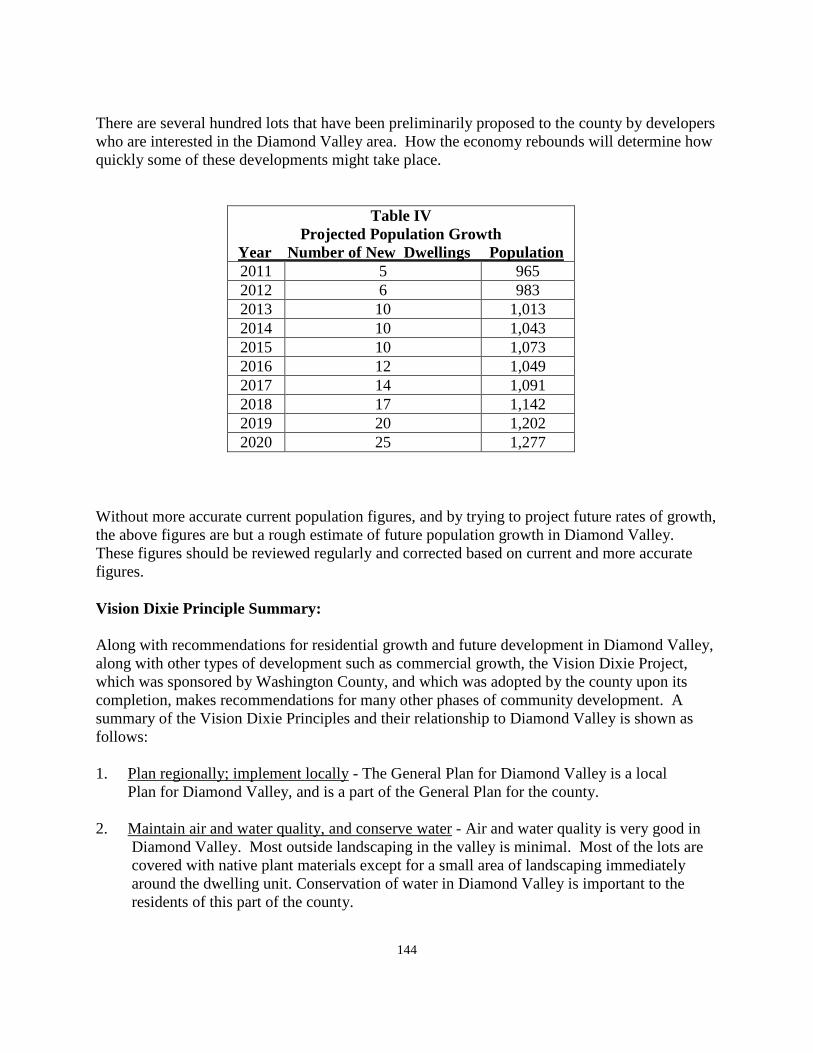
144
There are several hundred lots that have been preliminarily proposed to the county by developers who are interested in the Diamond Valley area. How the economy rebounds will determine how quickly some of these developments might take place.
Table IV Projected Population Growth
Year Number of New Dwellings Population 2011 5 965 2012 6 983 2013 10 1,013 2014 10 1,043 2015 10 1,073 2016 12 1,049 2017 14 1,091 2018 17 1,142 2019 20 1,202 2020 25 1,277
Without more accurate current population figures, and by trying to project future rates of growth, the above figures are but a rough estimate of future population growth in Diamond Valley. These figures should be reviewed regularly and corrected based on current and more accurate figures. Vision Dixie Principle Summary: Along with recommendations for residential growth and future development in Diamond Valley, along with other types of development such as commercial growth, the Vision Dixie Project, which was sponsored by Washington County, and which was adopted by the county upon its completion, makes recommendations for many other phases of community development. A summary of the Vision Dixie Principles and their relationship to Diamond Valley is shown as follows: 1. Plan regionally; implement locally - The General Plan for Diamond Valley is a local Plan for Diamond Valley, and is a part of the General Plan for the county. 2. Maintain air and water quality, and conserve water - Air and water quality is very good in
Diamond Valley. Most outside landscaping in the valley is minimal. Most of the lots are covered with native plant materials except for a small area of landscaping immediately around the dwelling unit. Conservation of water in Diamond Valley is important to the residents of this part of the county.
145
3. Guard our signature landscapes - see the section of this plan relative to open space development.
4 Provide rich, connected natural recreation areas and open space - also covered in the report
dealing with open space, and recreation development in the community. 5. Build a balanced transportation system - The county has developed a county-wide
transportation plan. See section III of the General Plan for information dealing with transportation in Washington County. See also the road section of this community Plan.
6. Get centered by focusing on growth in walkable-mixed use centers. Mixed use centers are
difficult to develop based on the current pattern and the limited use of any mixed use projects based on the limitations caused by septic effluent. Commercial development areas may be identified on the General Plan map, economic potential will be weighed by a commercial business prior to making a decision to bring a business to Diamond Valley.
7. Direct growth inward - Diamond Valley was developed as a compact subdivision
development. There has been some scattered development on the low hills east of the main development, but, for most part, growth expansion has, up to this point, been controlled. Future development should be done by moving outward, not by leap-frogging outward and then filling back in to the valley.
8. Provide a broad range of housing types - this has been discussed previously. A broad
range of housing types is not possible without of installing a waste disposal system. 9. Reserve areas for industry - this is discussed in the following section dealing with
industrial development. There is little potential for industrial development in Diamond Valley.
10. Public land conversion - No conversion is proposed or needed for proper build-out or
growth of Diamond Valley. Commercial Development: Commercial development is non-existent in Diamond Valley, except for some home occupations of a commercial nature. Home occupations will probably continue to grow as the area expands. In some of the other "bedroom" communities in the county, home occupations make up a significant element in those communities. One goal of the Vision Dixie Project is to try to make communities as sustainable as possible. This means that residents should be able to find work where they live, and that circulation through the community might be better accomplished with walking and bike paths as opposed to automobiles. In light of the Vision Dixie policies, the General Plan has attempted to identify an area where convenience commercial services in Diamond Valley could be located in an effort to reduce Highway 18 traffic traveling to St. George or Veyo for incidental commercial needs.
146
Highway commercial development is not recommended by the General Plan. There is no benefit to Diamond Valley in trying to stop traffic on Highway 18 to spend money in Diamond Valley. Any commercial development should be for the use and benefit of the residents of the valley without regard to whether or not anyone from outside the valley stops here. Whether or not commercial business comes to Diamond Valley depends more upon economic decisions, than it does a future land planning recommendation. Industrial Development: It is difficult to attract industrial or manufacturing business to an area without ready access to an interstate freeway. The likelihood of bringing industrial development to Diamond Valley would appear to be very unlikely. Existing industrial development consists of the extraction of cinders at the cinder cone, and the minimal amount of decorate rock removed for decorative purposes. Even though the area of land covered by cinders is included within the total land use, only one portion of the cinder pit is used for cinder extraction. A portion of the cinder pit is within Snow Canyon State Park, and will not be developed industrially by the State Park. Public Services: A section on public services as they relate county-wide is found at the beginning of this section, Section VII, of the General Plan. Some comments are re-stated herein as they might relate specifically to the community of Diamond Valley. Electricity: Electric service in Diamond Valley is provided by the Rocky Mountain Power Company. A few years ago a new electric sub-station was constructed about mid-way between Diamond Valley and Dammeron Valley. With the completion of this sub-station, the power company is better able to serve this area of the county. The same power company is also moving toward an increase of capacity between the sub-station at Sigurd, Utah, and the sub-station located adjacent to Dixie Deer Estates in Washington County. With the completion of this additional transmission line, Diamond Valley should be provided with sufficient electrical power to provide for all future growth that might take place for many years to come. Natural Gas: A number of years ago, the Questar Gas Company installed a natural gas line from a point near the town of Central parallel to Highway 18, and running toward the St. George valley. The installation of this line made natural gas available to all of the communities along the way, including Veyo, Winchester Hills, Diamond Valley, and Dammeron Valley. This line was inter-connected with the line serving the St. George Valley from the Interstate Freeway line, giving service to most of the county from either direction. This supply of natural gas should be sufficient to serve all of the communities presently connected to the system for both current demand and for future growth.
147
Water: Water in Diamond Valley is currently provided by the Diamond Valley Water Company. This is a mutual water company owned and operated by the residents of Diamond Valley. There may also be other water sources in the valley that are privately owned. The supply of water owned by the water company is projected to be adequate to serve all of the recorded building lots in the valley, as well as such things s the school, park, fire station, church, etc. The Washington County Water Conservancy District provides supplementary water to many parts of the county as well s to many of the incorporated cities and towns. The District has indicated that that they are willing to provide additional water to the Diamond Valley area as development continues to take place. This source of water should provide a stable water source to Diamond Valley well into the future. Sewage Disposal: Presently, liquid waste is disposed of by means of individual septic tanks. These have been approved for all of the platted lots in Diamond Valley, as well as some lots not within regularly platted subdivisions. This system has seemed to serve the valley well up to this point. However, based upon a ground water study performed by Hansen, Allen, and Luce, Engineers, in 1998, their study indicated that most of Diamond Valley is located on the Navajo Sandstone formation, which is the formation from which most of the ground water serving southern Washington County is found. Further, based upon their report, if each currently platted and recorded lot in Diamond Valley was occupied with a home, the valley would exceed their recommended density for septic tanks. As a result, of this study, development of additional subdivision lots has been limited for some time. More recently, a number of alternate on-site waste disposal systems have been approved by the State Department of Environmental Quality, and are now being approved for use in various areas of Utah. Some developers are looking at these methods as a means of eliminating the possibility of ground water pollution, and are actively considering such methods to allow further subdivision of the land in Diamond Valley. Washington County has contracted with the Water Conservancy District to oversee sewage disposal in the western part of the county. As an unincorporated part of the county, Diamond Valley is under the supervision of the Water District to oversee sewage disposal. Should Diamond Valley determine at some point to incorporate, another consideration for the community would be to petition the City of St. George to connect to the St. George sewer system which currently serves Ivins, Santa Clara, and Washington City, in addition to the City of St. George. Outfall lines already extend to the southerly end of Winchester Hills, which could make connection to this system preferable to the installation of one or more on-site treatment plants in the community. Dammeron Valley is interested in incorporation for the very purpose of connecting to the St. George sewer system. If both of these areas were to make a joint
148
application to St. George City, it could reduce the cost to install an outfall line to serve both areas at the same time. Roads: Road maintenance in the community of Diamond Valley is currently provided by the Washington County Road Department. There is a combination of roadway types presently existing in the valley. Not all of the roads are dedicated roadways. Many of the lesser improved roads are considered to be roads by right of use. In other words, the road has been there for many, many, years, and has been used by the public to travel to and from certain areas of the county. In the county, the state classifies roads as class "B" roads. Financing for maintenance of county roads comes from the Utah Department of Transportation through a funding formula that allows different amounts of maintenance money for different types of roads. Dirt roads receive the least amount of funding, paved roads receive the most. There are approximately twenty-five miles of roads in Diamond Valley. The actual amount of funding is set by the state and is adjusted annually. It tends to fluctuate from year to year. Road maintenance funds come from user fees derived from the gasoline tax, which somewhat depends on how many miles a person drives and how much gasoline they use. It has long been the policy of the county to maintain roads essentially in the condition in which they were created. If property owners in a given area want to have their roads improved to a higher standard, the position of the county would be that when the owners of an area bring their roads up to a higher standard, the county will then maintain them at the new standard. This is sometimes done through an improvement district that spreads the cost of improvement over a period of usually ten years, instead of a one time payment up front from the property owner. Under the Washington County Land Bill adopted by Congress in April, 2009, and signed by the President, the Bureau of Land Management is required to identify a route for an east-west right-of-way for the future construction of a major route for a right-of-way for the construction of a major collector roadway. The General Plan for the county has identified four alternatives for possible consideration which may, or may not, be the same as those routes identified by the BLM. One of the potential future routes passes through the habitat conservation area from Mile Post 13 in Washington City and connects with Highway 18 at the intersection with Snow Canyon Parkway. Two other routes begin in the Ledges area of St. George City with one route turning north on the Cottonwood road and then eastward towards Leeds, the other turning south on the Cottonwood road and connecting to Mile Post 13 in Washington City. The last of these four alternatives begins in Diamond Valley and goes eastward to Leeds staying completely north of the habitat plan area. The likelihood of any of these routes being constructed is probably many years away. The congressional bill requires that the BLM consult with the county and the City of St. George in making a decision on any route. Once that decision is made, the county will amend their
149
transportation map to adopt the agreed upon route. This decision will not be made for two or three years into the future. Fire Protection: Fire protection in Diamond Valley is provided by the South Western (SWSSD) Special Service District. This service is expected to remain much the same as it currently is for the foreseeable future. A new fire station has recently been constructed in the Diamond Valley area to better serve the residents of the valley. The department is made up primarily of volunteer firemen from within the community. Public Safety: Police protection is provided is provided by the Washington County Sheriff's office. This service will continue as long as Diamond Valley continues as an unincorporated part of Washington County. This method of police protection would also continue if Diamond Valley was incorporated until such time as the town created their own law enforcement department. Some communities have contracted with the county to increase the amount of sheriff's visibility in their community through a specific contract calling for more sheriff's protection in exchange for additional funds being raised by the community. Solid Waste: A Solid Waste Board made up of one representative from each city or town, along with one member of the county, oversee the collection of solid waste in the county. This board contracts with a private company to provide the collection of waste in the county. There is a central land fill location which is owned by Washington County and managed by the solid waste company. That site is expected to be sufficient for many years to come. This system of management and oversight is also expected to continue Building Inspection: Building inspection of new construction in Diamond Valley is provided by the county building department. The cost of a permit in the county is presently about $2,000.00 for an "average" home. The cost of a permit is established to pay for the cost of the service provided and is not intended be subsidized by residents of the county in general. The county has no significant impact fees outside of the fee for the preservation of the Desert Tortoise which fee is collected county wide. Some incorporated communities also contract with the county to provide building inspection services, Communication: Most of Washington is served by the CenturyLink communication company. In addition to CenturyLink services there are a number of private cellular companies providing service within the county. Except for the possibly of a cellular tower somewhere in Diamond Valley, it would appear that communication services are sufficient for the present time. There are communication
150
services provided through cable television and computer companies and from satellite communications. Flood Control: Because of the closed nature of Diamond Valley, flooding has, over the years, been a problem in many parts of the valley. The county has completed a flood control plan to determine the projected amount of runoff that could occur at any given time. The county has agreed to work with the community, over a period of time, as funding can be identified, to implement the engineering plan. This could include the installation of storm drains, or other measures, to help alleviate the flooding problem. This has been an ongoing problem for many years with which the county will continue to be involved. Annexation/Incorporation: Some years ago, the Diamond Valley area gave some serious thought to possible incorporation. Incorporation as a stand along town is still an option that the community is able to consider at any time. Should that issue arise in the future, this General Plan would provide a basis, with some additions, to completing an updated feasibility study for the community to consider relative to annexation. Incorporation into St. George City is always another option to consider. Since the annexation of the Ledges area into the City, it would be possible for Diamond Valley to annex to St. George City and still leave the Winchester Hills area out of the city. Dammeron Valley to the north has also discussed the possibility of incorporation. One of the current reasons for that consideration is that if either community, or both of them, were to incorporate, St. George City has indicated they would be favorable to extending the current sewer line to serve either or both of these communities. In order for any significant growth to occur in either valley, either a sewer line would need to be extended to serve the community, or a self contained package plant would have to be constructed by each individual area. An outfall line may be less expensive than a self contained plant. The county would support such a decision by either of these communities. The decision is a local decision to be made by the residents of each area. It is not a county decision and the county will continue to support each area as an unincorporated part of the county.
151
WASHINGTON COUNTY COMMUNITY SURVEY ANALYSIS FOR
THE COMMUNITY OF DIAMOND VALLEY 2010-2011
On August 31, 2010, staff members of the County Planning Department met with citizens of the community of Diamond Valley at the Diamond Valley Water Company Building. The Diamond Valley Land Use Map was reviewed with the individuals present. Because of the small number of citizens that attended the meeting, a statistical analysis of the results of the questionnaires filled out at the meeting and received since the meeting would not be of significant value. However, following is a summary of the questions and comments that have been responded to by residents of Diamond Valley. The length of time that the comments of the community members had lived in the community averaged about eight years. The family size was slightly higher than the county average at about 4 years. All of the respondents were home owners as it can be expected that most of the home owners in Diamond Valley are owners of the homes that they live in. There is a small amount of agricultural land in the valley. This includes land that was formerly devoted to a sod farm, and which has since been converted to growing alfalfa. A large number of reasons were given for living in Diamond Valley. These included such things as living close to the mountains, National forest, and the National Park and State Parks. Other reasons include having opens pace, the opportunity to have livestock animals and poultry, a quiet community, recreational opportunities, a safe environment, ability to watch wildlife, a dark night sky, and clean air. It is easy to see why residents like living here in this community. The character of the community should be preserved. Some methods for doing so include having proper zoning ordinances in place, not extending water or sewer lines into new undeveloped areas, or into areas where development would not be appropriate. All existing farm land should be preserved and protected for as long as the owners choose to continue with agricultural pursuits. The development of walking / bicycle trails and routes should be identified and developed, in connection with the BLM and the Forest Service where appropriate. There is concern about the use of off-road vehicles on the roads of the community. Not too much concern about speeding on public streets, some need for continued road maintenance, high concern about unlawful / unsafe use of OHV riders. Proliferation of OHV routes through and around the community is a high concern.
152
There is presently very little commercial business in Diamond Valley, outside of some home occupations that are licensed by the county. More commercial or industrial development may be good for the county, but not recommended for location in the Diamond Valley community area. Public services received generally high to good ratings with areas such as law enforcement. Cell phone services, and adequate notification of residents of meetings, etc., are areas that are in need of improvement. Diamond Valley has a very well developed recreation park in the community. Further recreation development would be desirable. Other facilities that have been recommended for consideration include such things as an expanded trail system connected to other areas, water trails development where appropriate in the county, and a community equestrian center that could keep and maintain horses. The best way to notify residents of meetings and activities affecting the community could be done by posting notices with large print at post office box locations, and by creating an E-mail list of residents who could be contacted relative to upcoming meetings, etc. Many citizens participated in the Vision Dixie project which recommends that the county follow through with Vision Dixie principles in preparing plans for the various areas in the county. Other comments that were made include:
• Avoid any roadways through the Red Cliffs Desert Reserve, which has now been placed in a National Conservation Area by action of Congress.
• Safeguard the "Golden Goose" that is Diamond Valley, the incredible scenery, clean air, diverse recreational opportunities, and abundant open space and wildlife.
• Drainage problems still need to be resolved. A time line and commitment need to be agreed upon with the community to finish the flood control project.
• Some approved culverts still need to be installed
153
EAST ENTERPRISE AREA GENERAL PLAN
2010 - 2011
Introduction: East Enterprise is an unincorporated part of Washington County. Residents and others should take time to review Section I of the County General Plan which discusses planning in general, the basis for planning, and the purpose of planning. Many of the things mentioned in the beginning of Section VII of the County General Plan are also relevant to the residents of this part of the county. The General Plan provides guidelines for the future for this particular part of the county in addition to those things that are applied county wide in the other sections of the General Plan. The East Enterprise area came about over a number of years. There have been three subdivision developments recorded in this area. These were Enterprise Ranchos which was recorded June 20, 1962, the Phillips Ranch Phase 2 recorded in June of 1986, and a one lot subdivision labeled the KM subdivision recorded on October 24, 2006. The Enterprise Ranchos subdivision was platted and recorded a number of years prior to the county adopting its first subdivision ordinance. It contains 98 lots. The Phillips Ranch Phase 2 subdivision contains only 7 large lots, and the KM subdivision contained only 1 lot. These subdivisions, except for the one lot subdivision, were recorded as "dry" subdivisions without any provision for providing water for the subdivided lots. Over the years, other parcels of land have been sold by metes and bounds without ever having been subdivided. There was also a court ordered sale of the balance of the Gilliam property to settle the estate of B.B. Gilliam after his death. B.B. Gilliam was the original developer of the Enterprise Ranchos subdivision. Most of the various lot sales that have taken place for many years have been zoned by the county zoning ordinance and zoning map to recognize these scattered lot sales as "legal non-conforming" lots in order to allow the owners of the lots to be able to obtain building permits for these scattered parcels. Geography and Topography: The East Enterprise area of the county is largely a relatively flat land area lying adjacent to the City of Enterprise on the west, the Iron County line on the north, and the Dixie National Forest boundary on the east and south. The National Forest land tends to be mountainous while the valley is composed of farm land and is generally flat. There is one major highway that runs through the area. It is State Highway 18 that runs between Enterprise City and the Iron County line. This highway also connects the City of Enterprise with the City of St. George which is located 43 miles to the south of Enterprise. The East Enterprise area is also 50 miles from Cedar City to the east in Iron County via State Highway 56 which is located north of the Iron County line and connects Cedar City with settlements to the west in Lincoln County, Nevada.
154
The climate in the Enterprise valley consists of four distinct seasons. Summers are generally mild, and winters can be very cold. The elevation is about 6,000 feet. The entire East Enterprise area contains approximately 5,500 acres of private land. Much of the land is in an agricultural use of one kind or another. Most of the northern area is in agricultural production. The central part includes in residential development and the southern part of the valley is mostly vacant and in agricultural livestock grazing, Land Use: There is one small parcel of land in the central part of the valley, adjacent to State Highway 18, which is identified as commercial land. It contains a contractor's storage yard as opposed to a general commercial use. There is no other commercial development. There is commercial business located north of the Iron County line which includes the Crossroads Equipment Company sales building. A review of the land use of the valley is tabulated in the following table:
Table I Existing Land Use
Residential Development 523 acres Agricultural (farming) 1,208 acres Agricultural (Livestock grazing, and vacant land.)
3,758 acres
Industrial development 12 acres
TOTAL: 5,502 acres The above figures may not be totally survey accurate, but they paint a relative picture of the various types of land use. Considering the private land in the valley, there is still much land available for various types of land development. Agricultural Development: Most of the citizens responding to the planning questionnaire requested that the area remain much as it is today. Actual development of the valley has been generally very slow over the years. It should also be identified in this Plan that the East Enterprise area constitutes most of the irrigated farm land that remains in Washington County that is not currently being transitioned into residential development. The amount of agricultural farm land is estimated to contain about 1,208 acres of land. Sufficient water appears to be available to allow this land to continue to be used as irrigated farm land. The other major farm area in the county, located in the Washington Field area south of the City of Washington, is rapidly disappearing as a farm area leaving the Enterprise area as the major farm area in the county. The pressure to change the land in this valley from farming to
155
residential is not a major concern at this time. The General Plan recommends that the irrigated farm land in East Enterprise continue to be used as it is today. If this land is not already in a green belt classification it should be placed therein, and agriculture protection areas should be created as necessary. Residential Development: There are currently almost 60 dwelling units existing in East Enterprise. The average family size is large compared to the average in Washington County which is currently an average of about three residents per dwelling, Using the average family size from the questionnaire, the population of the East Enterprise area would be about 300 residents. Using the county average, the population would be about 180 residents. When the census figures are collected every ten years by the Federal Government, they only identify the population in incorporated cities and towns and do not calculate the population in any of the unincorporated residential areas of the county. Over the past ten years there have been 18 building permits issued in the East Enterprise area. If that same number of permits was extended forward for an additional ten years, it would mean the same number of permits to be issued in the next ten years would be an additional 18 permits. This would translate, using the questionnaire family size, into about 90 new residents, or using the county average family size it would translate into about 54 new residents giving the area a ten year protected population of about 234 to 390 residents. Based upon a total land area in the valley of about 6,500 acres of land, the density of the population in East Enterprise is about 110 acres per dwelling unit which is actually very low. The population density compared to the amount of land for most of the areas of the county that are unincorporated is low compared to the density of the various cities and towns in the county. The Vision Dixie Summary: According to the responses from the questionnaire circulated in the area, some of the residents of East Enterprise did participate in the Vision Dixie planning project. The outgrowth of the study and recommendations by the committee charged with reviewing the material collected was a series of guidelines and policies aimed at guiding future growth in the county. A summary of the Vision Dixie study, adopted by the county and most of the incorporated cities and towns in the county is summarized for the residents of East Enterprise as follows: 1. Plan regionally, implement locally - The General Plan for East Enterprise is being
prepared for the residents of this area specifically, and is also a part of the County General Plan. It deals with aspects of the future of this area and may be amended or expanded from time to time as necessary, still dealing with the concerns of this area, and not with the county at large.
2. Maintain air and water quality, and conserve water - Air and water quality is good in East
Enterprise. The quality of culinary water was given good ratings by those filling out the
156
questionnaire last year. Water conservation is also evident in the area inasmuch as there is not water to waste. Irrigation of crop land depends upon wells to provide water for irrigation. With a number of drought years, the water table has declined. This year, with a high amount of water being absorbed into the water table, it may reverse the ground water supply here as it has done in other areas of the State during one of the highest water years on recent record.
3. Guard our signature landscapes - The view shed in East Enterprise is primarily toward the
east and south on the Dixie National Forest. This forest land is primarily open space and is not proposed for any other type of development. There is no action on the part of the county, or the residents of this area of the county, to request the release of any forest land for urban development. It should be protected from development in order to guard the view shed.
4. Provide rich, connected natural recreation areas and open space - There are not a lot of
recreation facilities provided in East Enterprise. There have been some suggestions made relative to the creation of a recreation center, a community park, and similar facilities for the use of residents in the area. However, with the amount of open space on the National Forest that are so close by the residents, there is not a lot of support for additional recreation facilities within the area.
5. Build a balanced transportation system - This item is best considered in the urban areas
of the County. The only public transportation system in the county currently exists in a portion of St. George City. Cost will keep this system from spreading county-wide. There may sometime be a transportation system between the lower St. George valley and the City of Enterprise. Should this happen, East Enterprise will have access to such a system. It is not proposed in the near future.
6. Get centered by focusing on growth in walkdable - mixed use centers - This area has not
developed over the years as a walkable community. It was not envisioned as a walkable community when the original subdivision activity took place. It is not likely to become a walkable community in the future unless a planned development of some kind is proposed which would, within itself, provide a walkable situation for the residents that lived there. It is difficult in existing development to retrofit them into this principle of the Vision Dixie Plan. It should be the goal of the county to require that all newly planned projects consider the walkabilty of their proposed development against this principle of the Vision Dixie Plan
7. Direct growth inward - Over time it may be possible to do an amount of infill between
current and proposed development. This would be a step toward meeting the concept of the Vision Dixie Plan. It could be accomplished by future development. One of the General Plan recommendations is to provide protection to the existing farming areas in order to protect farming as long as possible.
8. Provide a broad range of housing types - In an area where a sewer system is not available
for use in development, it is difficult to approve any development that cannot use septic
157
tanks as a means of waste disposal. This principle has application in areas where a sewer system is available to the residents. Only single family homes are likely to take place in areas where septic tanks are in use. Septic tanks do not support any significant amount of high density development.
9. Reserve areas for industry - There have been some suggestions relative to commercial
and industrial development in the area. Such uses would, of necessity, be located adjacent to State Highway 18. With the State Highway system extending eastward to Cedar City and the Interstate Freeway system, this could be accomplished in this part of the county. The General Plan does not attempt to identify any specific area for industrial development other than to state that it must be in relation to the State Highway system rather than anywhere else in the valley.
10. Public land conversion - No land in East Enterprise is needed for conversion from public
to private land ownership. This policy of the Vision Dixie Plan would have no need for application in this part of the county.
Commercial Development: Commercial development is non-existent in this area of the county. The General Plan recommends that commercial development not be allowed to take place as strip commercial development along the State Highway. Strip development would not benefit the residents of the area and would not be likely to bring significant traffic from the highway to use the services offered. That is not to say that a commercial center somewhere in the valley would not be useful to the residents. This is the reason that the Vision Dixie Plan suggests walkable communities where commercial business could be located within three-fourths of a mile from all residents. Such a facility as part of a planned development could, in the future, provide useful commercial business for the benefit of the residents. Keep in mind that commercial development does not usually take place until an economic study indicates that a developer of a commercial business has an opportunity to receive a return on the investment. That may yet be some time away in this area of the county. Industrial development: Industrial development has already been discussed in as a part of the Vision Dixie Plan review discussed above. While industry taking place in this area could be viable based on the major highway access available between here and I-15 in Cedar City, or using the railroad at Cedar City or Modena. The General Plan does not suggest any specific location, only that it be in proximity to the highway system through the area, and not a part of the agricultural farming area unless it is an agricultural industry. Public Services: A section of the General Plan deals with public services as they relate county-wide is found at the beginning of this section, Section VII, of the County General Plan. Some comments are stated in this part of the Plan as they relate specifically to the area of East Enterprise.
158
Electricity: East Enterprise is provided with electrical power by the Rocky Mountain Power Company. With already completed and currently proposed upgrades to their system, the power company feels that they can adequately provide power to most of the unincorporated areas of the county well into the future. The General Plan strongly recommends that in choosing a right-of-way for the new line proposed between Sigurd and Red Butte follow existing power line routes, and that it not pass through the private area in East Enterprise, and that it does not impact the National Forest view shed to the east of the area. Natural Gas: Technically, natural gas service is available to East Enterprise. There is a stub line that comes from the main transmission line into the City of Enterprise. The problem comes from being able to tap that line with a pressure reducing station, and the cost of extending natural gas service throughout the area for use by residents. The cost of doing this is currently prohibitive. The General Plan would recommend that the gas company work with the local area to make natural gas fuel available to this area of the county at an economical cost. Water: There is no culinary water system serving this area in Washington County. All of the homes in East Enterprise are served by private wells, or in some cases by wells shared between home owners. To obtain a well permit a person must obtain a water right, usually from an irrigation source, convert it to a culinary right, and drill a well. There are some water rights available from land that has been farmed but which is no longer in agricultural production for one reason or another. The lack of an area wide water system is probably the single largest factor in limiting residential growth in the area than any other single reason. Sewage Disposal: This public service has been previously discussed in this Plan in relation to residential development and the growth and development of the area. Presently residents are served by septic tanks as a means of liquid disposal. One improvement that could be made to septic tanks would be to have the tanks inspected on an annual basis to determine their continued ability to provide the service for which they were installed. If they were inspected regularly and pumped as often as necessary for good maintenance, they should continue to serve the needs of the area will into the future. An inspection and maintenance system could alleviate this potential concern. The General Plan would recommend that a maintenance system in the area be considered for the area at some time in the future. The current number of dwellings is not sufficient to make this a viable option.
159
Roads: There is a combination of road designations in East Enterprise. The major highway running through the area is State Highway 18. It is maintained by the Utah Department of Transportation. There are two recorded subdivisions in the area having dedicated county roads. However, many of these roads have never been constructed and are a right-of-way only. There are many other roads in the area that have never been dedicated. The policy of the county for many years has been to maintain county roads in the same condition and degree of improvement that they were in at the time they were dedicated. If residents of an area desire improvements to the roads in their area, the county will create a special improvement district to bring the roads to the current county standard. Improvement costs can be spread out over a period of time, usually about ten years. After the improvement, the county will maintain the roads in the improved condition. Undedicated roads are not maintained by the county. The county currently maintains the Bench Road along with one or two other roads that have been determined as county roads by right of use over a long period of time. Fire Protection: East Enterprise is currently served by the North Central Fire District which was organized to provide fire protection services to this part of the county. It is a volunteer fire department and a number of residents of the area belong to this fire department, but because the department has no fire fighting equipment, they participate with the Enterprise department as volunteers. At this time there is only one fire hydrant in East Enterprise. A plan is in place to provide additional hydrants. The Fire District contracts with the City of Enterprise to provide fire fighting equipment, and to respond to fires in the East Enterprise area. The volunteers in this area also train and participate with the Enterprise City department. Each of these systems participates with the county fire chief's association for training, and they cooperate together for the good of the residents of the Enterprise valley. Solid Waste: The City of Enterprise and the unincorporated area of East Enterprise participate in the Washington County Solid Waste District. Pickup of waste in this area is collected in the same manner as it is in various communities throughout the county. Individual collection cans are available to the residents and waste is regularly collected by the District. Building Inspection: Building Inspection for dwelling units and other types of building construction is provided by the county building department. The cost of building permits is established to defray the cost of inspection during the period of construction. Building permit fees in the unincorporated areas of the county are significantly less than found in most of the incorporated cities and towns in the county.
160
Public Safety: Police protection in the area is provided by the Washington County Sheriff's office. This service will continue as long as the area continues as an unincorporated part of Washington County. Some communities desiring greater protection have contracted with the county to increase the amount of sheriff's visibility in their area through a specific contract calling for more protection in exchange for additional funds being raised in the area. Communication: Most of Washington County is served by the CenturyLink communication company. In addition to CenturyLink services, there are a number of private cellular companies providing service within the county. Citizen response to the planning questionnaire resulted in a mixed response to the question of cellular services. Services appear to be generally satisfactory, but companies should continue to upgrade and improve services to the residents. Certain cellular companies appear to be better able to provide their customers with service, and there may still be certain parts of the area where service is limited. Flood Control: There are two areas of the valley where flooding can be a problem. The wash coming out of Holt Canyon can create problems under certain conditions. The county recently constructed a new bridge over Bench Road because the prior bridge was washed out. The General Plan recommends that the county work with the forest service in order to keep the Hold Canyon wash which originates on National Forest land, in order to keep this wash clear of trees and other debris as the wash flows through this area. Another wash is called the Cottonwood Wash and also originates on Forest Service land and runs through the western part of East Enterprise and empties into Shoal Creek near the northern end of the valley. This was could have some of the same problems as are associated with the Holt Canyon wash and the General Plan recommends that the county work with the forest service to maintain the upper reaches of this wash as well. Incorporation or annexation: One final issue related to public services is the question of incorporation. Under Utah State Law, a petition for incorporation must originate from within the community that desires to pursue this alternative. Whether or not this is an alternative that should be considered in this area is the decision of the residents living in this area. The county does not promote incorporation, or annexation. The county feels that government that is closest to the people is the best form of government. It will support any decision that the residents of any unincorporated area of the county decide to do or not to do.
161
In each area of the county where planning meetings have been held with the residents, it has been expressed that the residents would like to keep things just as they are. Physically, most of the areas have changed very little over a long period of time. However the residents of these areas continue to grow older, and in most cases, the replacement by new, younger families does not take place. Therefore, to keep things just as they are is something that is not possible to happen. The question is not whether things change, but rather, "Will we as citizens be prepared to give direction and input to change when it happens, or will we sit back and wait until something happens, and then wish what we had been able to do something about the change after it has taken place." To be aware of what is happening, and to give citizen input to projected change before it takes place is the opportunity for the residents of this community as a result of the General Plan study that is contained herein.
WASHINGTON COUNTY COMMUNITY STATISSTICAL SURVEY FOR
THE AREA OF EAST ENTERPRISE 2010 - 2011
1. Residency status: a. How long have you lived in this area? 37 year average b. Number in family 5 average c. Home owner 100 % d. Land owner 100 % 186 acres average 2. Please mark the characteristics that you value the most or that help you choose to live or
own property in this area: a. Born or raised in the area 80 % b. Close to family, friends, or neighbors 100 % c. Close to mountains 80 % d. Like the open space 100 % e. The opportunity to keep horses, animals, etc. 80 % f. Quiet community 80 % g. Recreation opportunities 60 % h. Safe environment 100 % i. Small town atmosphere 100 % j. Other: 3. Should the rural atmosphere be preserved? a. Yes 100 % No b. How? Control type of growth, good zoning regulations, don't sell your property
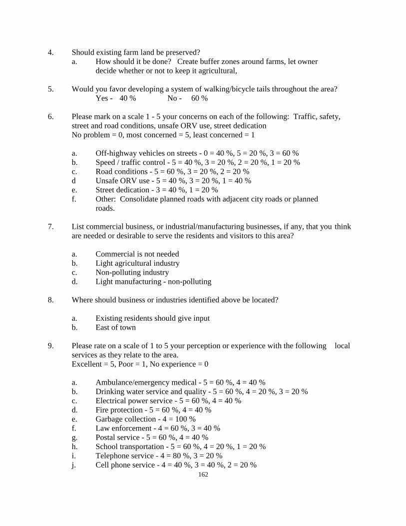
162
4. Should existing farm land be preserved? a. How should it be done? Create buffer zones around farms, let owner decide whether or not to keep it agricultural, 5. Would you favor developing a system of walking/bicycle tails throughout the area? Yes - 40 % No - 60 % 6. Please mark on a scale 1 - 5 your concerns on each of the following: Traffic, safety,
street and road conditions, unsafe ORV use, street dedication No problem = 0, most concerned = 5, least concerned = 1 a. Off-highway vehicles on streets - 0 = 40 %, 5 = 20 %, 3 = 60 % b. Speed / traffic control - 5 = 40 %, 3 = 20 %, 2 = 20 %, 1 = 20 % c. Road conditions - 5 = 60 %, 3 = 20 %, 2 = 20 % d Unsafe ORV use - 5 = 40 %, 3 = 20 %, 1 = 40 % e. Street dedication - 3 = 40 %, 1 = 20 % f. Other: Consolidate planned roads with adjacent city roads or planned roads. 7. List commercial business, or industrial/manufacturing businesses, if any, that you think
are needed or desirable to serve the residents and visitors to this area? a. Commercial is not needed b. Light agricultural industry c. Non-polluting industry d. Light manufacturing - non-polluting 8. Where should business or industries identified above be located? a. Existing residents should give input b. East of town 9. Please rate on a scale of 1 to 5 your perception or experience with the following local
services as they relate to the area. Excellent = 5, Poor = 1, No experience = 0 a. Ambulance/emergency medical - 5 = 60 %, 4 = 40 % b. Drinking water service and quality - 5 = 60 %, 4 = 20 %, 3 = 20 % c. Electrical power service - 5 = 60 %, 4 = 40 % d. Fire protection - 5 = 60 %, 4 = 40 % e. Garbage collection - 4 = 100 % f. Law enforcement - 4 = 60 %, 3 = 40 % g. Postal service - 5 = 60 %, 4 = 40 % h. School transportation - 5 = 60 %, 4 = 20 %, 1 = 20 % i. Telephone service - 4 = 80 %, 3 = 20 % j. Cell phone service - 4 = 40 %, 3 = 40 %, 2 = 20 %
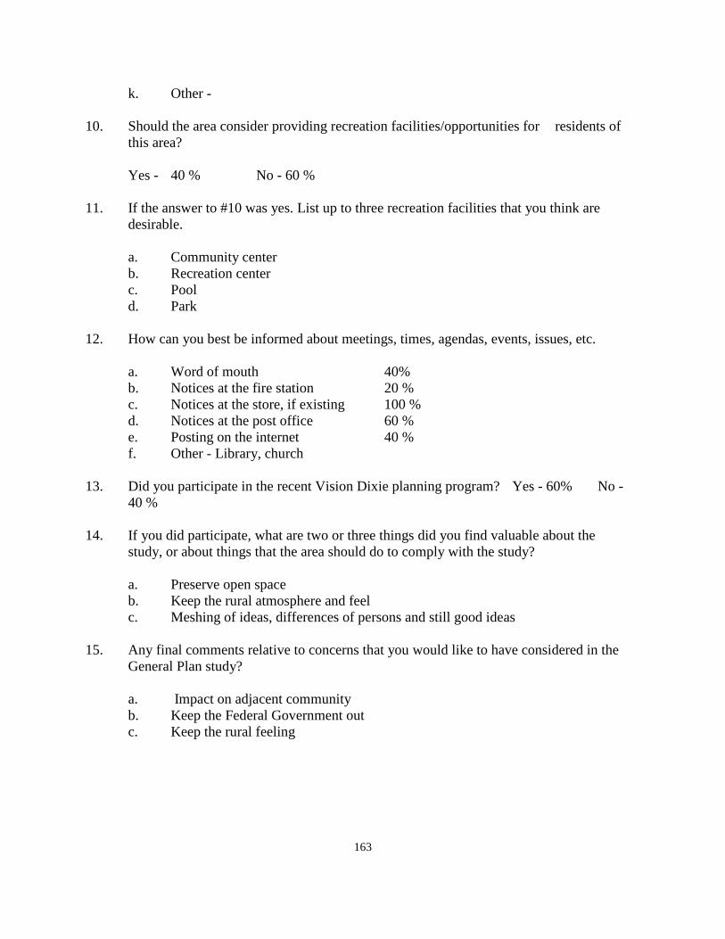
163
k. Other - 10. Should the area consider providing recreation facilities/opportunities for residents of
this area? Yes - 40 % No - 60 % 11. If the answer to #10 was yes. List up to three recreation facilities that you think are
desirable. a. Community center b. Recreation center c. Pool d. Park 12. How can you best be informed about meetings, times, agendas, events, issues, etc. a. Word of mouth 40% b. Notices at the fire station 20 % c. Notices at the store, if existing 100 % d. Notices at the post office 60 % e. Posting on the internet 40 % f. Other - Library, church 13. Did you participate in the recent Vision Dixie planning program? Yes - 60% No -
40 % 14. If you did participate, what are two or three things did you find valuable about the study, or about things that the area should do to comply with the study? a. Preserve open space b. Keep the rural atmosphere and feel c. Meshing of ideas, differences of persons and still good ideas 15. Any final comments relative to concerns that you would like to have considered in the
General Plan study? a. Impact on adjacent community b. Keep the Federal Government out c. Keep the rural feeling
164
WASHINGTON COUNTY COMMUNITY SURVEY ANALYSIS
FOR THE AREA OF EAST ENTERPRISE
2010 - 2011
On August 24, 2010, staff members of the county planning department met with citizens of the area of East Enterprise at the county library in Enterprise City. The group was small, but those present entered into a discussion of the East Enterprise area of Washington County. Questionnaires were completed by those in attendance with others able to submit the same the same information over the internet or to fill out the form and submit it to the county planning office. Following is a summary of the questions and the comments that were responded to by those present. There were very few questionnaires filled out at the meeting, and even less that were subsequently submitted to the county. The statistical review was small enough that the validity of the information contained therein may be somewhat questionable. Nevertheless, following is a review of the information collected. The length of time that residents have lived in the area was rather long with an average of 37 years. This is greater than most of the unincorporated communities in the county. The average family size indicated was five. This is more than double the average county family size which is very close to three. It is more likely that the overall family size in this area, if all residents responded, would be closer to the county average. There are many reasons for living in this area of the county. The major reasons given by the residents of this area were being close to family or friends, liking the open space, a safe environment, and a small town atmosphere. These are all valid reasons for living here and are similar to most of the unincorporated communities in the county. As to how to maintain the characteristics that most people enjoy, answers include: controlling growth, asking residents to "not sell" their property, and developing and enforcing good zoning regulations. The same response relative to farm land included the following as to how to protect the farm land: Create buffer zones around the farms, let owners decide whether or not to keep it agricultural. This last comment would be contradictory with the ways to protect the rural atmosphere of the area. If owners are being encouraged not to sell their land, on the other hand, how do you give farmers the choice to farm or not. These are some of the decisions that need to be made in the area.
165
Some of the respondents to the questionnaire felt that it would be nice to have walking and bicycle trails in the area while the majority of those filling out questionnaires felt that these trails are not necessary. The decision should be left up to the residents. In the area of traffic safety, OHV use, road conditions, etc., none of these situations raised to the height of a major concern in the area. Some of the conditions had some concern, but none were raised to the area of a major concern. One additional concern was raised by a respondent, namely that of making sure that plans for new streets be coordinated with the street plan of the City of Enterprise. This is a good recommendation. There does not seem to be the same opposition to commercial or industrial development in east Enterprise that has occurred in other unincorporated communities in the county. To have no commercial was mentioned. On the other hand, several comments were made relative to having commercial or industrial development in the area as long as it is of a non-polluting variety. A valid comment was that local residents should give input as to where such development should take place, and to have their comments strongly considered. Questionnaire respondents were asked to respond to their satisfaction, or lack thereof, with a number of public services including such things as ambulance service, drinking water, electrical power, fire protection, garbage collection, law enforcement, postal service, school transportation, telephone and cellular service. The only public service that received approval from everyone was Garbage collection. Telephone service was also rated quite high. Most of the public services rated satisfactory responses. Cell phone service was about as low as any service was rated, but even this service was given a reasonable rating depending on your phone company and where you lived. The question related to providing recreation facilities received a no response higher than a yes response. There were several facilities mentioned that would be desirable to many residents. These facilities included a community recreation center, a pool, and a park were all facilities that were suggested. How to let residents know of upcoming events or county information showed that posting at the store (in Enterprise) would be the best way of letting people know of things that they needed to know about. Posting notices at the post office was the next highest method of informing people suggested. East Enterprise is the only unincorporated area where the majority of those filling in the questionnaire actually attended the Vision Dixie planning program. This was an encouraging sign. Several things were mentioned as positive things coming from the study which included preserving open space, keeping a rural feel to the area, and sharing ideas with people with different thoughts and backgrounds. Final comments from the questionnaire included keeping the Federal Government out of the area, keep a rural feeling, and determine the impact of east Enterprise on the City of Enterprise which is adjacent.
166
THE GUNLOCK COMMUNITY GENERAL PLAN 2010 - 2011
Introduction: Gunlock is an unincorporated part of Washington County. Residents and others should take time to review Section I of the County General Plan which discusses planning in general, the basis for planning, and the purpose of planning. Many of the things mentioned in the beginning of Section VII are also relevant to residents of this part of the county. The General Plan provides guidelines for the future for this particular part of the county in addition to those things that are applied county wide in the other sections of the General Plan. The Gunlock community is among the older communities in Washington County. In order to understand the background and history of this community, the General Plan quotes a paragraph or two from the History of Washington County put together in 1996 by Douglas D. Alder and Karl Brooks as follows: "Some settlements were outgrowths of the initial ones. The land was limited at Santa Clara and the young, newly arrived settlers were capable of ranging widely in search of forage and timber. Jacob Hamblin's brother William, nicknamed "Gunlock", soon found a location not unlike Santa Clara a few miles up river, directly on the Old Spanish 'Trail. There in a narrow valley were small openings beside the Santa Clara Creek where crops could be planted. William Hamblin moved his family there, and his relatives Dudley and Jeremiah Leavitt and Isaac Riddle joined him. Being up river was a comfortable feeling, but the settlers would soon find themselves vulnerable to floods. Another threat was Indians who stole their cattle. The town, called Gunlock, after its colorful founder, is an example of the individual enterprise of young families seeking land wherever they could stake their homes rather than being in a planned Mormon colony. The Leavitt and Riddle families moved there from Santa Clara, and the Holt and Hunt families later migrated from Hebron." Unlike some other of the early communities that were settled and later were abandoned and become "Ghost Towns", Gunlock has remained a viable community since its settlement. While it has not expanded and grown like some of the cities and towns in the lower part of the county, Gunlock remains an important part of Washington County. Geography and Topography: Geographically, Gunlock lies northwest of the cities of Santa Clara and Ivins along the Santa Clara River. Lying between these cities and Gunlock is the Piute Indian Reservation. Access to the community is via Old Highway 91 which went westward from Santa Clara, over Utah Hill, and into Arizona and Nevada. This road, for many years was the connection with Utah and from points north and east to the Pacific coast and the Los Angeles basin. Turning north from Highway 91 while still within the boundary of the Indian reservation, it is a short distance to the
167
community of Gunlock. Going north from and east from Gunlock, the county road connects with Highway 18 between St. George City and Enterprise City at the community of Veyo. Gunlock is located at an elevation of about 3,700 feet, or about 1,000 -1,100 feet above the City of St. George. Elevation wise Gunlock lies about mid way between the Mojave Desert and the Colorado Plateau. The Gunlock bench slopes from the ridge along the west side of the community to the Santa Clara River which generally bisects the valley from north to south. The land form then rises to the base of the eastern hills above which lies the upper and lower Sand Cove Reservoirs. At one time a significant amount of electrical power was generated from the fall of water from the top of the bluff to the valley floor. The entire community of Gunlock is generally identified as including about 6.992.31 acres of land which includes the farming area to the north of the community. The land south of the community to the Gunlock Reservoir may also be considered a part of Gunlock.
Table I.
Land Ownership/Management in Gunlock Bureau of Land Management 2,888.67 ac 4.51 sq. mi. State of Utah - Trust Land + UDWR 1,062.41 ac 1.66 sq. mi. State Park 450.15 ac. 0.70 sq. mi. Quasi Public Land - inc. school sites 6.89 ac. 0.01 sq. mi. Private Land 2,584.19 ac. 4.04 sq. mi.
Total: 6,992.31 ac. 10.92 sq. mi.
. Land Use: The land at the northern end of the community is largely given to farming. It was settled about the same time as the community itself by the Holt family from the Hebron area. The land remained in the Holt/McGregor family until more recent years when it was obtained by the Smith family who maintains and farms the land now. There is currently no land in the valley identified as commercial land, although at one time there was a store / post office that occupied a building on the east side of the highway through town about mid way from the north to the south end of the valley. That same land also contained a mobile home park which has more recently has been purchased by the Gunlock community for a park site. Across the river toward the reservoir is an industrial operation that produces various rock products. This gravel operation provides significant safety to the Gunlock area by dredging the Santa Clara River between the town site and the reservoir to help keep flood water from backing up into the community during times of flood.
168
Of the land in the area under control of the State, there is a block of State Institutional Trust land lying west of the Gunlock Reservoir, and another block of State land lying at the northern end of the valley. Land to the north-west and to the east of Gunlock is under the jurisdiction of the Bureau of Land Management. The actual Reservoir site is managed by the Utah State Department of Parks and Recreation. This Reservoir receives significant visitor use during the warm months of the year for water sports and for fishing opportunities. Much of the private land lying west and north of the Gunlock Townsite is open space land and is devoted primarily to livestock grazing. Southeast of Gunlock is a large tract of BLM land that has officially been designated as the Red Mountain Wilderness area by act of Congress in the spring of 2009. It encompasses much of the land lying north of the City of Ivins and south of the community of Dammeron Valley. It is bordered essentially by State Highway 18 and Snow Canyon State Park on the east, and runs westward almost to Gunlock. A review of the land use of the valley is tabulated in the following table:
Table II. Existing Land Use
Residential Development 14.26 ac. Agriculture (farming) 1,313,77 ac. Agriculture (Livestock grazing including vacant land)
955.97 ac.
Industrial development (minerals) 25.11 ac. Public / Quasi Public 6.89 ac. Wilderness Designation 45.73 ac.
Total: 2,361.73 ac.
The above figures may not be totally survey accurate, but they paint a relative picture of the various types of land use. Considering the private land in the valley alone, some areas (955.97 ac.) of the private land is undeveloped. There is still much land available for various types of land-use development. Gunlock is a small island of private land surrounded by public land. While there is still much private land available for development, the resources to do so, water, waste water, etc., make any extensive growth in the Gunlock area very unlikely. Most of the citizens responding the planning questionnaire requested that the community be allowed to remain much as it is today. It remains today not unlike it did in the late 1800's and if, for no other reason than the two things indicated above, no significant changes in the current size of the community are projected by the General Plan. It should be noted as an item of interest, that in 1888 a school was formed in Gunlock with 27 students. 18 of the students belonged to the Dudley Leavitt family. When Dudley Leavitt
169
moved, 18 of the students also moved, and the school closed. The General Plan does not project the construction of a new school in Gunlock any time soon. Agricultural Development: This section has been discussed in the previous section dealing with open space. The amount of cultivated agriculture, 1,313.77 acres, is limited due to the availability of irrigation water, and the limitation of cultivatable land. The climate and growing season are conducive to agricultural pursuits. The nature of the valley significantly limits any extensive agricultural development beyond the current land use. Most of the agricultural land belongs to one operator. It will likely remain agricultural as long as the owner wants to continue farming the land, but it could change at some future date. Much of the private land does lend itself to livestock production and grazing. The amount of livestock that can be maintained is also limited however, based upon the amount of feed that the land will produce in any given season. Residential Development and Population: There are currently some 54 dwellings according to the land use map of Gunlock. The average family size, based upon the questionnaire, is quite large compared to the county average. With a county average of 2.8 to 3.2 residents per dwelling, this would project an average population in Gunlock of between about 150 to 170 residents. Over the past ten years there have been six building permits issued for the Gunlock area. If this same pattern continues for the next ten years, the community could expect another six permits to be issued in Gunlock. This would provide another 18 residents for a total of 170 to 190 residents in the next ten year period. There was one new subdivision proposed in recent years for Gunlock, containing 9 lots. Because of the lack of topsoil over the bedrock in this subdivision, a single septic system was proposed at the bottom of the hill where it was located. It was approved with the use of this collection system. However, with the decline nation-wide in the economy, development has not taken place. If this project is renewed at some point in the future, it would add 9 building lots in Gunlock. If the water supply is able to supply that many more water connections, that number of lots and new dwellings could easily amount to the total expected growth in population during the next ten years, making the projected population in the range of 200 - 220 residents. Population Density: The projection of existing population and projected population are discussed in the previous section dealing with population and population growth. However the number of existing and projected new growth over the next ten years shows one of the lowest population densities in the county. The 2,550.55 acres of private land, divided by the projected population provides the density in terms of the number of acres per resident. In the case of Gunlock, that amounts to about 11.6 acres per dwelling unit. By any standard, that is very low.
170
Vision Dixie Summary: According to the responses from the questionnaire circulated in the community, none of the residents participated in the Vision Dixie Study that was undertaken by the county just a few years ago. The outgrowth of the study and recommendations by the committee charged with reviewing the material collected was a series of guidelines and policies aimed at guiding future growth in the county. One of the lowest areas of projected future growth would have to be the Gunlock area. Nonetheless the summary of the Vision Dixie Study, adopted by the county and most of the incorporated cities and towns in the county is summarized for the residents of Gunlock as follows: 1. Plan regionally, implement locally. The General Plan for Gunlock is a locally prepared
plan for this area only, and is a part of the overall county General Plan. It deals with aspects of the future of Gunlock and may be amended from time to time as necessary, still dealing with the concerns of the Gunlock area and not the county at large.
2. Maintain air and water quality, and conserve water. Air and water quality is very good
in Gunlock. The quality of culinary water in Gunlock was rated very high by those completing the planning questionnaire. Water conservation is also evident in the community; inasmuch is there is not a lot of extra water to waste.
3. Guard our signature landscapes - All of the surrounding hillsides are maintained in an
open space category. To the southeast of town is a congressionally designated wilderness area. The character of this area is not likely to change.
4. Provide rich, connected natural recreation areas and open space - There are not a lot of
community recreation facilities provided in Gunlock. The rodeo grounds located at the south end of the community provides some recreation opportunity. One respondent suggested that a community park would be nice to see developed. Otherwise, residents did not see a need for local recreation facilities. The Gunlock Reservoir is considered part of the Gunlock area and is a major recreation area in the summer months. There is a major wilderness area close by, and most of the land surrounding Gunlock is open space which offers a good deal of recreation opportunity in nearly all directions.
5. Build a balanced transportation system - Most of time, Gunlock can be accessed from
either of two directions. That would be south to Old Highway 91 at the Indian Reservation, or north and east to Highway 18 in Veyo. In addition, a secondary access is available via the sand cove reservoirs connecting to Highway 18 adjacent to the community of Dammeron Valley.
Other types of transportation other than private vehicles are not likely to be found serving Gunlock anytime soon. During times of high water on the Santa Clara, none of the existing systems will be adequate to serve the community. Residents should simply be
171
aware that during times of flood, Gunlock is probably going to be cut off from access to other areas of Washington County as happened in 2005, and again in 2010.
6. Get centered by focusing on growth in walkable- mixed use centers - One could consider
that Gunlock is generally a walkable community insofar as being to walk quite easily from one end of the community to the other. Being a mixed-use community is another matter. Located on the banks of the Santa Clara River prohibits any type of high density development because of the lack of sewage disposal facilities. On site treatment facilities are available for use now in Utah. However, if the whole community was connected to an on site system, the cost to each resident would still be prohibitive.
7. Direct growth inward - Gunlock would appear to be doing well in meeting this planning
recommendation of the Vision Dixie Plan. As mentioned above, Gunlock is basically a walkable community. There are not very many areas where subdivision and growth could occur outside of the current valley. The Smith property to the north could, at some future time, support conversion of the farmland to residential use. This represents about the only area where additional development could reasonably take place.
8. Provide a broad range of housing types - This element is discussed in Section 7 above.
The use of septic tanks eliminates most proposals any type of use other than single family dwellings.
9. Reserve areas for industry - The only existing industrial development in the valley is an
operation tied to the existing availability of mineral development. There are no sites that would conveniently lend themselves to industrial development because of the transportation problem to existing major highways and freeway systems.
10. Public land conversion - No land in Gunlock is needed for conversion to private
ownership to provide for community expansion. This policy would not apply in the Gunlock area.
Commercial Development: Commercial development is non-existent in Gunlock except for some possible home occupations. In some of the other "bedroom communities in the county, home occupations make up a significant element. One goal of the Vision Dixie Project is to try to make communities as sustainable as possible. This means that residents should be able to find work where they live, and that circulation through the community might better accomplished with walking and bike paths as opposed to automobiles. One resident suggested that a service station/convenience store might be useful in Gunlock. Economic demand drives most decisions to construct commercial facilities. If the Gunlock Reservoir was much larger than it actually is, it might be able to attract a service station/convenience market in that area. The General Plan would agree that such a facility
172
somewhere in the Gunlock area would be a benefit to the community. It would be difficult to suggest where such a facility might locate, or whether there would be any economic benefit to an owner to provide such a facility in Gunlock. While the General Plan agrees with this suggestion, but can find no site on which it could be neither located, nor any economic benefit to a proprietor of such a facility at the present time. Industrial Development: Industrial development was discussed earlier as one of the Vision Dixie guidelines. There is only one industrial development in the Gunlock valley. It is related to mineral development and provides a benefit to the area by dredging material from the Santa Clara River above the Gunlock Reservoir from time to time. Other industrial development in the Gunlock area is not projected at any time in the near future. Public Services: A section on public services as they relate county-wide is found at the beginning of this section, Section VII, of the General Plan. Some comments are re-stated herein as they relate specifically to the community of Gunlock. Electricity: Electric service to Gunlock is provided by the Rocky Mountain Power Company. With upgrades to their ability to provide power to the westerly side of the county, along with plans to continue to upgrade their system, communities such as Gunlock should be provided with the needed electrical services for many years to come. Natural Gas: The nearest supply line of natural gas in the westerly part of the county is parallel to Highway 18, and runs from a substation near Central southward to the City of St. George. It is not expected that a loop through Gunlock will be constructed in the near future. Gunlock will still be served by propane gas service for those residents that desire to use this form of fuel. Water: Water in Gunlock is currently provided by the Gunlock Special Service District. This board is operated by the residents of the community. It appears to be adequate to serve the current needs of the community, having received upgrades during the past few years. It is not sufficient to supply unlimited growth and development, which is not expected to take place. In the recent planning questionnaire filled out by many residents, the water system received very high remarks insofar as satisfaction with the service is concerned. It is expected that the water company will continue to make upgrades and improvements to the system as time and money to do so permit. The present system should be adequate for the future decade of the Gunlock General Plan.
173
Sewage Disposal: This public service has been discussed previously in this plan in relation to residential development and the growth and development of the area. Presently, homes are served by septic tank as the means of liquid disposal. One improvement that could be made to these septic tanks would be to have the tanks inspected on an annual basis to determine their continued ability to provide the service for which they were installed. If they were inspected regularly and pumped as often as necessary for good maintenance, they should continue to serve the needs of the community well into the future. On-site treatment facilities are now available for use in areas where septic tanks are no longer considered a viable alternative to a sewage collection system. The cost of such a system in Gunlock would be prohibitive given the current and projected population. The only concern raised by the General Plan is in relation to keeping the current system of individual septic tanks in a healthy condition, considering the proximity of the community to the Gunlock Reservoir and the Santa Clara River. An inspection and maintenance system could alleviate this potential concern. The General Plan would recommend that a maintenance system in Gunlock be considered. Roads: Road maintenance in Gunlock is provided by the Washington County Road Department. Financing for road maintenance comes from the Utah Department of Transportation through a funding formula that allows different amounts of maintenance money for different types of roads. There are hundreds of miles of roads in Washington County that the road department is charged with maintaining. The funding amount changes from year to year and is based upon payments received by the county from the state as a percentage of the income from the gasoline tax paid at the gas pump. This tax source, rather than the taxes paid to the county general fund have been the source of funding for the road department for many years. More recently, funds were received by the county to upgrade the two bridges serving Gunlock at the lower end of the community and just north of Gunlock going toward Veyo. This funding was obtained as a result of the 2005 flood that isolated Gunlock from the rest of the County. The flood of 2010 caused problems with these recent improvements. At the same time, the road connecting with Veyo was cut off by the flooding of the washes at the foot of the dugway leading up to Veyo. There was also flooding at the Old Highway 91 Bridge over the Santa Clara River in the Indian Reservation. Continued improvements of the access roads to and from Gunlock connecting it with other parts of the County are still a concern. However, even with recent improvements, opportunities for flooding at other locations can still cause Gunlock to become isolated in time of flood. This is
174
one area where the General Plan recommends that the county will still need to continue working to try to solve this problem. At this time residents should understand the difficulties that a flood on the Santa Clara River present, and prepare for isolation from the county at large during flood situations. One concern expressed by the residents of Gunlock is related to the bicycle groups that travel through Gunlock on a regular basis. Gunlock only has one road through the town and when groups tie up the road for a long period of time, it becomes very difficult for residents to do the things that they need to do. The General Plan makes several recommendations for the county to consider relative to this problem as follows: 1. Identify a bicycle lane through Gunlock. This may involve some widening of the roadway through the town. A bicycle lane should be marked on the pavement. 2. A bicycle lane must require bicycles to be in a single line not only through town but all
the way from Veyo to Old Highway 91. A sign on both ends of Gunlock should identify these regulations.
3. These requirements should be part of any county conditional use permit approval for bike groups anywhere on the Gunlock road with penalties assessed for violations.
4. Whenever bike groups requesting conditional use permits from the county are scheduled on the Planning Commission agenda, citizens from Gunlock should be notified of the meeting so that they can attend and express their concerns. It is not likely that the county can exclude all bicycle groups that want to ride through Gunlock any more that they can eliminate the St. George Marathon that takes place in October on Highway 18. But the General Plan recommends that consideration be given by the county as to how to better organize these rides through Gunlock to protect the health, safety, and welfare of Gunlock residents. Fire protection: Fire protection in Gunlock is one area in which the General Plan recommends that considerable effort be made to upgrade and improve the system. Gunlock is currently a part of the North West Fire District that includes most of the communities in that part of the County. Currently Gunlock has one brush truck, housed in a garage next to the community building, and a pumper which is housed outside and must have the water drained during colder months. Service is provided both by units elsewhere in the fire district as well as from the Fire Station in Ivins city. The General makes several recommendations for improvements to the Gunlock fire system. 1. Develop the necessary manpower to man fire suppression equipment in Gunlock which
involves creating a volunteer department, firemen being properly trained to respond to local fires and to respond to wildland fires that may threaten the community.
2. Contact other areas, Pine Valley being a good example, to find out how to properly organize in Gunlock to create a trained department. Training is available from within the North West District, from Ivins City, or cities or towns in the county.
3. Improve the facilities available by obtaining grant funds, available from several sources in the same manner as the community has done to upgrade the water system, and to
175
provide a fire station and the equipment necessary to protect those on the volunteer department. Grants for an isolated area such s Gunlock should rate high on the approval list from any source of funding, of which there are several.
4. Become an active participant with the North West Fire District, or create a singular fire district only in the Gunlock area.
5. Contract with a neighboring city, Ivins, for response to Gunlock fires to take care of some of the needs that the local department might not be able to handle.
Fire protection would appear to be one area in which Gunlock should make efforts to improve similar to other unincorporated communities. To study the model in Pine Valley would be a good place to begin. Public Safety: Police protection in Gunlock is provided by the Washington County Sheriff's office. This service will continue as long as Gunlock continues as an unincorporated part of Washington County. Some communities desiring greater protection have contracted with the county to increase the amount of sheriff's visibility in their community through a specific contract calling for more sheriffs’ protection in exchange for additional funds being raised by the community. Solid Waste: A solid Waste Board made up of one representative from each city or town, along with one member from the county, oversee the collection of solid waste in the county. This board contracts with a private company to provide the collection of waste in the county. There is a central landfill location which is owned by Washington County and managed by the solid waste company. This site is expected to sufficient for many years to come. The system of management and oversight is also expected to continue. Building Inspection: Building inspection for dwelling units and other types of building construction are provided by the county building department. The cost of building permits is established to defray the cost of inspection during periods of building construction. Building permit costs in the unincorporated communities are significantly less than found in most of the incorporated cities and towns in the county. Communication: Most of Washington County is served by the CenturyLink communication company. In addition to CenturyLink services there are a number of private cellular companies providing service such within the county. Citizen response to the planning questionnaire resulted in a mixed reaction to the question dealing with communication services. From the citizen response, it may be concluded that communications in Gunlock are generally adequate, with the General Plan recommending that communication providers continue to upgrade their services to the Gunlock area.
176
Flood Control: This subject received significant comment in the section dealing with roads. Therefore, it need not be repeated at this time. The General Plan recommends that the county continue to improve road conditions in areas that are subject to flooding in order to provide a better connection from Gunlock to the balance of the county during times of flooding. The efforts that have been made, particularly since the 2005 floods in the area, were a large step toward improvements the challenge of flood protection in Gunlock Cemetery: It was brought to the county during the public meeting in Gunlock that the Gunlock Cemetery is at capacity. The General Plan recommends that the county look at possible alternatives that might be identified on adjacent public land which could possibly be obtained under a public purpose lease for cemetery development. Incorporation: One final issue related to public services is the question of incorporation. Under Utah State law, a petition for incorporation must originate from the community wishing to pursue this alternative. The minimum number of residents required to request incorporation is 100 persons. Gunlock would qualify with the current population. Whether or not this is an alternative that should be considered further is a decision of the residents of Gunlock. The county does not oppose incorporation of a community. The county is not promoting incorporation of the unincorporated communities in the county, but would lend support in whatever decision a community might make. In each area of the county where the planning staff has held a meeting concerning planning in the unincorporated areas of the county, the one comment that was made at each and every meeting was the comment, "We like it just like it is." To keep things just like they are is a noble desire, but each and every resident gets one day older each day and year, which makes "keeping things the way they are," something that is not possible to have happen. The question then is not whether things change, but rather, "Will we as citizens of a given area be prepared to give direction and input to change when it happens, or will we sit back and wait until something happens in our area and then wish that we had been able to do something about the change after it has taken place." To be aware of what is happening, and to give citizen input to projected change, before it happens is the opportunity of the residents of this community as a result of the General Plan Study. On the other hand, of all of the unincorporated communities in this county, Gunlock will probably be involved in less change during the coming decade than any of the other unincorporated communities in the county. Now, if only we could come up with some way of keeping each resident just as they are today, without any change in age, health, or other condition of getting older.
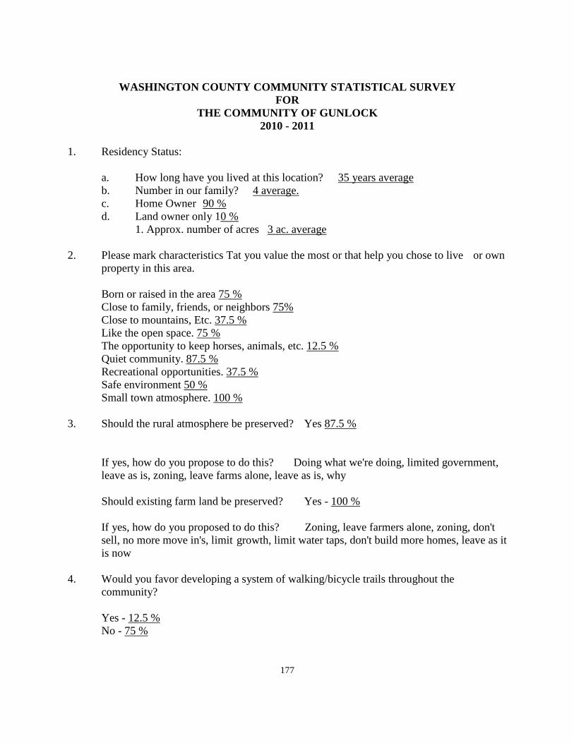
177
WASHINGTON COUNTY COMMUNITY STATISTICAL SURVEY
FOR THE COMMUNITY OF GUNLOCK
2010 - 2011
1. Residency Status: a. How long have you lived at this location? 35 years average b. Number in our family? 4 average. c. Home Owner 90 % d. Land owner only 10 % 1. Approx. number of acres 3 ac. average 2. Please mark characteristics Tat you value the most or that help you chose to live or own
property in this area. Born or raised in the area 75 % Close to family, friends, or neighbors 75% Close to mountains, Etc. 37.5 % Like the open space. 75 % The opportunity to keep horses, animals, etc. 12.5 % Quiet community. 87.5 % Recreational opportunities. 37.5 % Safe environment 50 % Small town atmosphere. 100 % 3. Should the rural atmosphere be preserved? Yes 87.5 %
If yes, how do you propose to do this? Doing what we're doing, limited government, leave as is, zoning, leave farms alone, leave as is, why
Should existing farm land be preserved? Yes - 100 % If yes, how do you proposed to do this? Zoning, leave farmers alone, zoning, don't
sell, no more move in's, limit growth, limit water taps, don't build more homes, leave as it is now
4. Would you favor developing a system of walking/bicycle trails throughout the community? Yes - 12.5 % No - 75 %
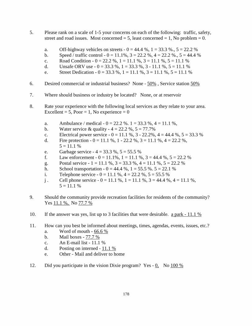
178
5. Please rank on a scale of 1-5 your concerns on each of the following: traffic, safety, street and road issues. Most concerned = 5, least concerned = 1, No problem = 0.
a. Off-highway vehicles on streets - 0 = 44.4 %, 1 = 33.3 %., 5 = 22.2 % b. Speed / traffic control - 0 = 11.1%, 3 = 22.2 %, 4 = 22.2 %., 5 = 44.4 % c. Road Condition - 0 = 22.2 %, 1 = 11.1 %, 3 = 11.1 %, 5 = 11.1 % d. Unsafe ORV use - 0 = 33.3 %, 1 = 33.3 %, 3 - 11.1 %, 5 = 11.1 % e. Street Dedication - 0 = 33.3 %, 1 = 11.1 %, 3 = 11.1 %, 5 = 11.1 % 6. Desired commercial or industrial business? None - 50% , Service station 50% 7. Where should business or industry be located? None, or at reservoir 8. Rate your experience with the following local services as they relate to your area. Excellent = 5, Poor = 1, No experience = 0 a. Ambulance / medical - 0 = 22.2 %. 1 = 33.3 %, 4 = 11.1 %, b. Water service & quality - 4 = 22.2 %, 5 = 77.7% c. Electrical power service - 0 = 11.1 %, 3 - 22.2%, 4 = 44.4 %, 5 = 33.3 % d. Fire protection - 0 = 11.1 %, 1 - 22.2 %, 3 = 11.1 %, 4 = 22.2 %, 5 = 11.1 % e. Garbage service - 4 = 33.3 %, 5 = 55.5 % f. Law enforcement - 0 = 11.1%, 1 = 11.1 %, 3 = 44.4 %, 5 = 22.2 % g. Postal service - 1 = 11.1 %, 3 = 33.3 %, 4 = 11.1 %, 5 = 22.2 % h. School transportation - 0 = 44.4 %, 1 = 55.5 %. 5 = 22.1 % i. Telephone service - 0 = 11.1 %, 4 = 22.2 %, 5 = 55.5 % j . Cell phone service - 0 = 11.1 %, 1 = 11.1 %, 3 = 44.4 %, 4 = 11.1 %, 5 = 11.1 % 9. Should the community provide recreation facilities for residents of the community? Yes 11.1 %, No 77.7 % 10. If the answer was yes, list up to 3 facilities that were desirable. a park - 11.1 % 11. How can you best be informed about meetings, times, agendas, events, issues, etc.? a. Word of mouth - 66.6 % b. Mail boxes - 77.7 % c. An E-mail list - 11.1 % d. Posting on interned - 11.1 % e. Other - Mail and deliver to home 12. Did you participate in the vision Dixie program? Yes - 0, No 100 %
179
WASHINGTON COUNTY COMMUNITY SURVEY ANALYSIS FOR
THE COMMUNITY OF GUNLOCK 2010 - 2011
On October, 2010, staff members of the county planning department met with citizens of the community of Gunlock at the town office. The group was small, but those present entered into a discussion of the Gunlock community. Questionnaires were completed by those in attendance with others able to submit the same information over the internet or to fill out the form and submit them to the county planning office. Following is a summary of the questions and the comments that were responded to by those present. The length of time that residents have lived in the community was rather long with an average of 35 years. This average is much greater than for most of the communities in the county. Some had lived in Gunlock for their entire lifetime which was much longer than 35 years. The average size of families in Gunlock was an average of 4. Many reasons were given for living in Gunlock. These reasons included being born or raised there, (75%); close to family, friends, or neighbors; close to the mountains; the opportunity to keep animals; a safe environment; a small town atmosphere. Most residents felt that the small town environment should be preserved. As to how to do this, the following comments were given: doing what we're doing; a limited government; leave us as is; zoning; leave farms alone. To preserve farmland in the area, which everyone who commented wanted to see done, some of the ways to do this were given including: zoning; leave farmers alone; don't sell; no more move-in's; limit growth; give no more water taps; don't build any more homes; and leave it as it is. A few of the respondents were in favor of developing a trail system in the area. The majority were not in favor of a trail or bicycle system. A few respondents considered off highway vehicles on the streets to be a problem. Most did not. However, most had significant concerns relative to traffic control and speed on the main street of Gunlock. As far as road condition was concerned, there were wide spread responses ranging from little concern by most residents to a few indicating a major concern. Consideration could be given to education of OHV users in Gunlock. There is some concern relative to the safe use of these vehicles by those using them on the streets of Gunlock. There are few undedicated streets in Gunlock; therefore, there was not much concern relative to whether or not roads needed to be dedicated.
180
Relative to the question of locating commercial development in Gunlock, 50% of the respondents felt that there should be no commercial business in the community, and the nearest they recommended having commercial business was at the reservoir. About the same number did not want to see significant commercial development take place, but felt that a service station would be beneficial to the community. In this day and age, a service station usually implies also having a handi-mart type of commercial business attached to the service station. The series of questions relative to existing public services received the following responses: Ambulance service is rated somewhere between fair to good, but not excellent. Water quality and service was rated very high by nearly all respondents. Water quality and service was the highest rated of all current public services. The current water company would appear to be doing a very good job in providing the needed commodity to the residents of Gunlock. Electrical service was also given a high rating by most respondents to the questionnaire, with only a few feeling that the service could be improved. Fire protection seemed to be somewhat evenly spread between good and fair with one poor recommendation and one excellent rating. Garbage service rated between good to excellent. Law enforcement was also spread out between poor to excellent. The Postal service generally received good to excellent ratings, as did telephone service. Receiving lower ratings was cellular service. The question of providing recreation facilities in Gunlock was very strong for not providing communities with one respondent suggesting that a park would be nice. The question on how best to be informed of meetings indicated that posting at the mail boxes was the preferred method with word of mouth being a close second. Some felt an E-Mail list of residents would be useful. At least one favored mail delivered to the home. This method would be the least likely to happen because of the cost involved to send letters to each home in the county who might be impacted whenever an issue arose relative to any given community. Some time ago, the county was involved in what was called a Vision Dixie planning effort. The responses to the questionnaire indicated that none of those responding had participated in the Vision Dixie project. A summary of the plan will be found elsewhere as a part of the community General Plan.
181
An addendum To
The Harmony Valley Area General Plan 2010 - 2011
HARMONY VALLEY GENERAL PLAN
INTRODUCTION The General Plan for the Harmony Valley is a part of the General Plan of Washington County. Planning in Washington County began about 1970 and has continued since that time. The most recent update of the plan was in November of 1995. However, the plan for the Harmony Valley at that time was very minimal; indicating that there would probably be a transition from agricultural uses to residential uses over a period of years. This latest update, adopted in 2011, comes during an economic downturn in the economy during which growth and development in the county has been significantly reduced. Therefore, the transition from agricultural to residential development has been very minimal for the past 5 or more years. The transition may increase again in the future, but with the size of the valley, will not change the rural character of the area for many years to come. BASIS FOR PLANNING The authority for a General Plan comes from enabling legislation passed by the State of Utah and found in the Utah Code, Article 17, which outlines the methods to be followed and charges the County Planning Commission with the development of a General Plan. Many other public agencies also are involved in planning for the areas that they are responsible for, such as the Bureau of Land Management, The National Forest and the National Park. All of these agencies are also involved with land in the Harmony Valley area of Washington County. PURPOSE OF THE PLAN The purpose of the plan is to serve as a guide for orderly development. It sets the pattern for growth and change. It expresses the goals as to what the area should look like in the future, and the policies or guidelines for achieving the goals. THE GENERAL PLAN AND ACTION Effectuating the Plan is the responsibility of public and private groups. The Plan alone does not cause things to happen, nor does it give precise recommendations for the development of various projects. The Plan provides the road map to follow. Vehicles of implementation such as the Zoning Ordinance, and the Subdivision Ordinance are needed to carry out the provisions of the General Plan.
182
BACKGROUND AND HISTORY Located in the north central part of Washington County, the Harmony Valley is considerably different that the lower parts of the County. This area of the County has four distinct seasons each year, has cold and sometimes stormy winters, combined with mild, cool summer seasons. The settlement of Washington County began in the Harmony Valley at Harmony Fort, just off the present I-15 freeway at the New Harmony interchange. The earliest settlers arrived in 1852, left for a year, and returned in 1854. Crops were raised in 1854 and the following winter was spent there. The fort was begun in 1854, and Brigham Young arrived and helped dig some of the dirt for the foundation. Washington County was created in March, 1852, with New Harmony being named as the County seat. The fort, 300' X 300' in size housed most of the people of Harmony. It had only one defect. It was made from adobe brick and the rain and wind dissolved the earthen walls during a severe storm in 1862. The severity of this storm and the subsequent loss of their homes, caused the people to move to higher ground to the west where the Town of New Harmony is now located. The Town has remained in the new location since the 1862 storm and has grown only minimally. In 1865 there were twenty-five families and 225 people in New Harmony. In recent years, development has taken place in many parts of the Valley. Subdivisions are now located in the vicinity of the old fort, to the south along Kanarra Creek and Ash Creek, and to the south of New Harmony Town. It is now expected that this growth and development will continue into the future. Because of the expected continued growth, there is a need for an updated General Plan for the Valley. UNDERSTANDING THE PLAN The General Plan identifies various land use categories and considers the use of each of these classifications. Many of these types of land use are considered in terms of the Goals and Policies that are adopted as a part of the Plan. Goals and policies are described as follows: A GOAL represents an objective relative to some aspect of development that the County has determined to achieve. A POLICY is an action that will allow, or help the County to achieve the desired goal. ELEMENTS OF THE PLAN The New Harmony Bench is a beautiful area with many unique characteristics. There are many qualities about the area that set it apart from other areas of the County. Therefore, as the area continues to grow and develop, it is necessary that the things that make the New Harmony Bench what is, are preserved. There is a limited amount of water in the valley and this will determine the extent to which development will take place. Historically, where water is, agriculture can flourish, or homes can be built. Where water does not exist, livestock grazing takes place. The
183
key to the success in the Plan for the Harmony Valley is to establish goals and policies that will allow development to take place, using the water that is available, but to guide the development into a pattern that will maintain and protect most of the values that have caused people to come to this area. The Goals and Policies of the County to accomplish this purpose are identified in the following sections of the Plan: Land Use: Open space areas Open space areas of the valley may include such things as Public Land, drainage channels and washes, unstable soils, reservoirs, livestock grazing lands, steep slopes, a lack of irrigation water, or a lack of culinary water. Land classified in open space should remain in this classification until any of the above conditions have been altered. At that time, the most appropriate land classification should be determined. Following are goal and policies relative to the open space classification and use of land in the Harmony Valley: GOAL: Identify open space areas within the valley and provide protection from development in the areas identified. Areas that may be hazardous in nature and are of an open space character should be maintained as open space in order to protect the health, safety, and welfare of the present and future residents of the valley. POLICIES:
• Maintain an open space designation along all of the major washes and streams running through the valley.
• Identify the 100 year flood plain along these streams and washes. In order to
protect the health, safety, and welfare of the residents. Do not issue building permits, or approve subdivisions in these areas.
• Encourage the public agencies to maintain their lands in an open space category.
Do not exchange public lands in this valley for private lands elsewhere in the County.
• Allow the public lands to provide a buffer zone between the private land in the
valley and other private lands outside of the valley area.
• Establish zoning classifications that will preserve the public lands and the other types of land uses identified herein as open space areas.
• Continue to encourage uses in open space areas that will encourage their
remaining open. This might include livestock grazing, recreation uses, water courses, reservoirs, and other similar uses.
184
• A more detailed study could be conducted to identify possible recreation opportunities that might be developed along the major streams in the valley such as Ash Creek, and Kanarra Creek.
• Such a study might include consideration for the development of parks, riding
trails; hiking and walking trails, etc. that have been identified in the 2010 citizen questionnaire as being desirable to develop in the Harmony Valley area.
• The parcel of BLM land near the Town of New Harmony should be acquired by
the Town to maintain future open space and recreation use of that property.
• Setbacks greater than the normal requirements of the Zoning Ordinance should be established near major washes, streams, and drainage channels. These areas should not be a part of subdivided lots for building purposes. .
• Work with the Utah Department of Transportation (UDOT), owner of the land surrounding the Black Ridge Reservoir, and the irrigation company who controls the water rights, to find a means to stabilize the elevation of the reservoir to protect "Old Highway 91" along the south side of the reservoir to guarantee the use of this roadway during all weather and run-off conditions. Without this policy the county cannot continue to maintain this section of roadway
Agricultural Land: Considerable agricultural land has historically existed in the Harmony Valley both in Washington and in Iron counties. Most of this land has been "dry" land because of a lack of water for irrigated crop production. The continued expansion of agricultural land in the area is not expected. In fact, given the natural course of events, agricultural land will continue to decrease and disappear. The county has identified its position relative to agricultural land with the following Goals and Policies. GOAL: To maintain the quality of life that is realized from having agricultural land around the valley. Promote the continued operation of agricultural land in the area. POLICIES:
• Follow policies identified in the section dealing with residential development. Many of these policies relate to the maintenance of agricultural areas.
• Deed to the County, home owners associations, or land trusts, the agricultural
land after one of the residential policies has been used to guarantee continued agricultural use. Groups then owning land could contract with those interested in farming the land to continue agricultural operations.
• Maintain a low overall density in agricultural areas, except as provided for in
density transfer and clustering provisions.
185
• Encourage green belt classification of agricultural land.
• Encourage the establishment of agricultural protection areas according to State
and County ordinance.
• Encourage installation of pressurized irrigation systems that would make more efficient use of available water.
• Educate new residents as to the agricultural character of the valley and solicit
their support for agricultural use of land to avoid citizen complaint against agricultural operations.
Residential Development Residential development has taken place at various locations in the Harmony Valley. The town of New Harmony is located near the westerly edge of the valley. Other developments have taken place near the interstate freeway and south and east of New Harmony Town. In order to give direction to residential development in the valley, the plan suggests a goal to be achieved and policies to help achieve the goal. GOAL: To provide for residential housing in attractive, functional neighborhoods to meet the needs of potential residents. POLICIES:
• Maintain strict standards concerning the size of homes, and encourage the landscaping of yard areas around homes. Use natural landscaping where practical.
• Continue to use the same standards for modular or manufactured homes as for
other types of residential construction.
• The Zoning Ordinance should be used to determine housing densities in different areas with an overall valley density of 5 acres per dwelling unit. Specific developments should not have a density of less than 2-1/2 acres per dwelling unit within the overall 5 acre density for all areas using septic tanks for waste disposal
• Care must be given in residential areas to follow the transportation plan of the
valley to make sure that vehicular traffic can circulate easily throughout the valley.
• Within the densities established by the Zoning Ordinance, encourage the transfer
of density to clusters of smaller parcels within the overall density requirement, thus providing large portions of the land to remain in agriculture or open space.
186
• Allow the transfer of clustered development from one density classification to another in order to create even larger areas of open space, unencumbered by residential development.
• Establish minimum lot sizes for cluster housing, or for transferred densities, that
will protect the health, safety, and welfare of residents from sanitation problems, but which will maximize the amount of open space and agricultural land preserved.
• Cluster and higher density development should only be approved in areas where package plant type waste disposal facilities have been established.
Vision Dixie Plan: A number of the residents of the Harmony Valley participated in the Vision Dixie Plan that was undertaken buy the county a few years ago. The outgrowth of the study and the recommendations by the committee charged with reviewing the material collected was a series of guidelines and policies aimed at guiding future growth in the county. The summary of the Vision Dixie Study, adopted by the county and most of the incorporated cities and towns is summarized for the residents of the Harmony Valley area by summary of the policies adopted in the Plan and relating them to this area. Policies:
1. Plan regionally, implement locally - The General Plan for the Harmony Valley area is a locally prepared plan for this area of the county only, and is a part of the overall county General Plan. It deals with aspects of the future of the valley and may be amended from time to time as necessary, dealing with the concerns of the residents of this valley and not related to the county at large.
2. Maintain air and water quality, and conserve water - This valley has a high standard of air quality. The low population density and the separation of this area from other more urban areas help to maintain good air quality. Water conservation has always been necessary because of a limited amount of water available in most of the subdivisions in the valley.
3. Guard our Signature Landscapes - The surrounding hillsides of this valley are maintained in an open space category on public land. With theVision Dixie Principles in place, it can be expected that the surrounding view sheds on the public land will be protected.
4. Provide connected natural recreation areas and open spaces - The surrounding public land areas provide considerable natural recreation areas. The Pine Valley Wilderness Area is adjacent to the valley on the west as part of the Pine Valley Mountains. The valley is surrounded by connected public lands including the National Forest, the Bureau of Land Management, and Zion National Park. These areas are all connected.
5. Build a balanced transportation system - There are no public transportation systems available to the residents of the Harmony Valley. Contact with the public transportation bus systems may be able to arrange for a stop at the New Harmony interchange, or for the
187
St. George Shuttle to stop at this interchange when residents have reservations to travel to areas in northern Utah.
6. Get centered by focusing on growth in walk-able mixed use centers - The Harmony Valley is a large geographic area. Because it was developed outside of the Vision Dixie Plan, the various developments are spread out with significant open space areas between them. Over time, some of these areas will fill in making some degree of walking useful in parts of the valley. At this time, a unified transportation system connecting each of these areas together is probably more important than to connect each of the various subdivisions by walking trails. The Harmony Valley fits the Vision Dixie Plan in providing satellite commercial centers throughout the county. A location within this valley would meet the criteria for a satellite commercial center.
7. Direct growth inward - Currently, most of the residential development is located in the "four corners" of the valley. The only direction for growth to take place in the future will be by infill into the central parts of the valley. This will happen when the major property owner submits plans for further residential development.
8. Provide a wide-range of housing types - This policy works well in the urbanized area of the county where sewer systems are available. It does not work well in the unincorporated areas of the county where sewer service is not available. It is very difficult to provide mixed use or a high density development using septic tanks.
9. Reserve areas for industry - Industrial development could exist in the Harmony Valley. However, he current freeway interchanges have developed primarily in a residential character. If industrial development should come to the valley, areas would need to be identified where freeway access is readily available without the need to travel through existing residential areas, or areas far from the freeway.
10. Public land conversion - The valley is surrounded by public land. None of this land is identified as being necessary for the future development of the valley.
Commercial Development Commercial development in the Harmony Valley should be kept to the minimum needed to serve the convenience needs of the residents and to provide for the needs of the traveling public on the Interstate Freeway. GOAL: Allow sufficient commercial development to provide for the convenience
commercial needs of valley residents, and to serve the traveling public. POLICIES:
• Limit highway commercial development to convenient locations adjacent to the freeway interchanges.
• Limit convenience commercial development to the freeway interchanges, and to
the incorporated community area.
• Do not allow strip commercial development along the major collector system of roadways.
188
• Consider other convenience commercial uses only as an integrated part of the overall development plan for large-scale residential developments.
• Consider other convenience commercial uses only as an integrated part of the overall development plan for large-scale residential developments, and as a means of meeting the provisions of the Vision Dixie Plan to make commercial areas as convenient to the majority of residents as possible
Transportation and Circulation It is important to provide for convenient movement of traffic in and through the Harmony Valley. The various developments need to be linked together to provide for a harmonious development of the area. Residents should not find it necessary to use the freeway to get from one residential neighborhood to another. GOAL: Provide a circulation system that will move people and goods safely through the valley with access from one residential area to another residential area and to the Interstate Freeway. POLICIES:
• Adopt a circulation system of streets as a part of this planning study.
• Require segments of roadways to be constructed as development takes place in any given area.
• Work with owners of open space, or agricultural land, to provide necessary major
or collector roads to be constructed through these areas to connect residential areas while maintaining a minimum of impact on the adjoining land.
• Identify, as part of the circulation system, a secondary access to the freeway from
the area in and around New Harmony.
• Require all new development to provide paved roadways as a part of the initial development of the subdivided property.
• Encourage the County to provide regular roadway maintenance of existing
County roadways, and to provide regular snow removal from these roads during the winter storm season.
189
Recreation There are many areas of potential recreation development in the Harmony Valley. The Plan should encourage the development of desirable recreation facilities throughout the valley. GOAL: Provide for the planning and development of appropriate recreational facilities for the residents of the Harmony Valley. POLICIES:
• A plan should be prepared identifying desirable recreation activities enjoyed or
desired by residents of the area
• A recreation plan may include parks, riding trails; walking or hiking trails, and other types of recreation activities, etc. that have been identified in the 2010 citizen questionnaire as being desirable to develop in the Harmony Valley area.
• Encourage the public land managers to continue a multiple use approach to the
management of BLM and National Forest lands which will allow for hiking, hunting, etc., on the public lands.
• Encourage the Town of New Harmony to prepare a plan for the development of
the isolated parcel of BLM land near the Town and to make application to the BLM to acquire this property under a recreation and public purpose lease.
• Encourage the Ash Creek Water Users Association to line the Ash Creek
Reservoir to provide for maintenance of water in the reservoir and the creation of recreational and/or fishing activities at the reservoir.
Public Services: As the area continues to grow and develop, the need for public services continues to increase. A determination should be made as to how best to provide the services that are needed by residents. GOAL: Create a mechanism for identifying and providing public service needs of the residents. POLICIES: Establish a committee of residents of the various parts of the valley to identify those services that would be most desirable for residents to enjoy.
• Prepare detailed plans, where necessary, for accomplishing the elements of the
needs study recommended above.
190
• Consider the creation of a Community Council to represent the residents of the unincorporated area of the valley, and coordinate the efforts of this council with that of the Town of New Harmony.
• Consider the creation of a Special Service District to serve all of the residents of
the valley, including those in New Harmony Town, in order to provide the means of accomplishing some of the needs identified by the residents. A Special Service District with locally elected leaders could provide a large measure of self-determination to residents of the area.
• Determine the services that might be provided through a Special Service District,
even though some services might not be needed at the present time. These services could be added at a later time without amending the District.
• Consider a unification of the various water systems in the valley into one water
district with professional management and operation.
• Consider the creation of Special Improvement Districts to provide for the paving or roads in subdivision that are not presently paved, but which property owners would like to see paved.
• Insure that services provided to the unincorporated areas of the County do not
result in double taxation upon the residents living in incorporated Cities and Towns.
• In the event that development densities endanger ground water supplies, be
prepared to initiate plans for construction of waste treatment facilities in the valley. This could become part of a special service district if it should become necessary.
• Consider other convenience commercial uses only as an integrated part of the
overall development plan for large-scale residential developments, and as a means of meeting the provisions of the Vision Dixie Plan to make commercial areas as convenient to the majority of residents as possible.
Public Safety: In the area of public safety, police protection is provided by the Washington County Sheriff's Office. This service will continue as long as the valley continues to be an unincorporated part of the county. Some areas in the county, who desire a greater presence of officers, have contracted with the county for an increased visibility of officers in exchange for additional funds being contributed by the area involved.
191
Road Maintenance and Improvement: Road maintenance and improvement has been identified as a major concern of residents in the valley. POLICIES:
• The General Plan encourages the development of frontage roads on both sides of
the Interstate 15 Freeway. Contact should be made with the Congressional delegation from Utah to encourage them to submit a bill before Congress to allow the construction of the east side frontage road. If approved by Congress, then UDOT should be contacted to provide funding for the improvement of this section of roadway between the two freeway interchanges.
• On the westerly side of the freeway, the General Plan recommends that contact be
made with the arm of the LDS Church that is managing the land in the New Harmony area to encourage approval of the frontage road on this side of the freeway. If approval is granted, UDOT should be contacted relative to the financing of a frontage road connecting the two interchanges together.
• The General Plan recommends that contact be made with the LDS Church relative
to opening up the roadway between New Harmony Town and the Kolob freeway interchange, and determine what would be required to allow it to become a county road, and to be improved to a higher standard than presently exists. The road running south from the library should be extended to connect to the road from the town of New Harmony to the freeway interchange at the Kolob area.
• Residents living in any of the various subdivisions in the New Harmony valley
area should discuss the needs of their specific subdivision relative to further road improvements. If significant interest exists to upgrade the condition of any of these roads, the General Plan recommends that contact be made with the county to determine cost estimates, etc., relative to roadway improvements. The General Plan recommends that consideration be given to creating improvement districts to ease the cost of improvements to individual home owners.
Annexation and Incorporation As the valley continues to grow and development, as the numbers of residents continues to increase, the time may come that it would be in the interest of residents to consider creating one governmental entity whether it came about through annexation, or incorporation of the presently unincorporated areas. GOAL: Provide unification of the valley through either annexation into New Harmony Town, or through the creation of a Town by another name to provide for the needs of the residents.
192
POLICIES:
• Work with New Harmony relative to the expansion of the Town to include the various developments that take place in the valley.
• Establish guidelines for annexation of unincorporated land into the Town that
may be followed by land owners desiring to become a part of New Harmony.
• Monitor the growth and development of the valley to determine at some point whether or not annexation of the entire valley or the creation of a new town by another name would be of advantage to the residents in being better able to respond to their needs and desires.
• Recognize that the purpose of a Town or City is to provide for the urbanized
needs of an area that cannot conveniently be provided by individual property owners. Also recognize that Washington County is not an urban service County and that urban services may better be provided through Town or City government.
• The county feels that the form of government that is closest to the people is the
best form of government. The county does not oppose the incorporation of a community. The county does not promote incorporation of an area nor does it oppose such incorporation. The county will lend support to whatever decision the area might make.
• Any desire of the residents of the New Harmony Valley to become a part of Iron
County would need to make contact with the legislators from the two counties in order to have a bill submitted to the legislature for consideration. The approval of a change in the boundary of a county must be approved by the State Legislature and the Governor. The local commissioners in both of the counties would need to be in agreement with a change before it would likely gain any traction with the legislature
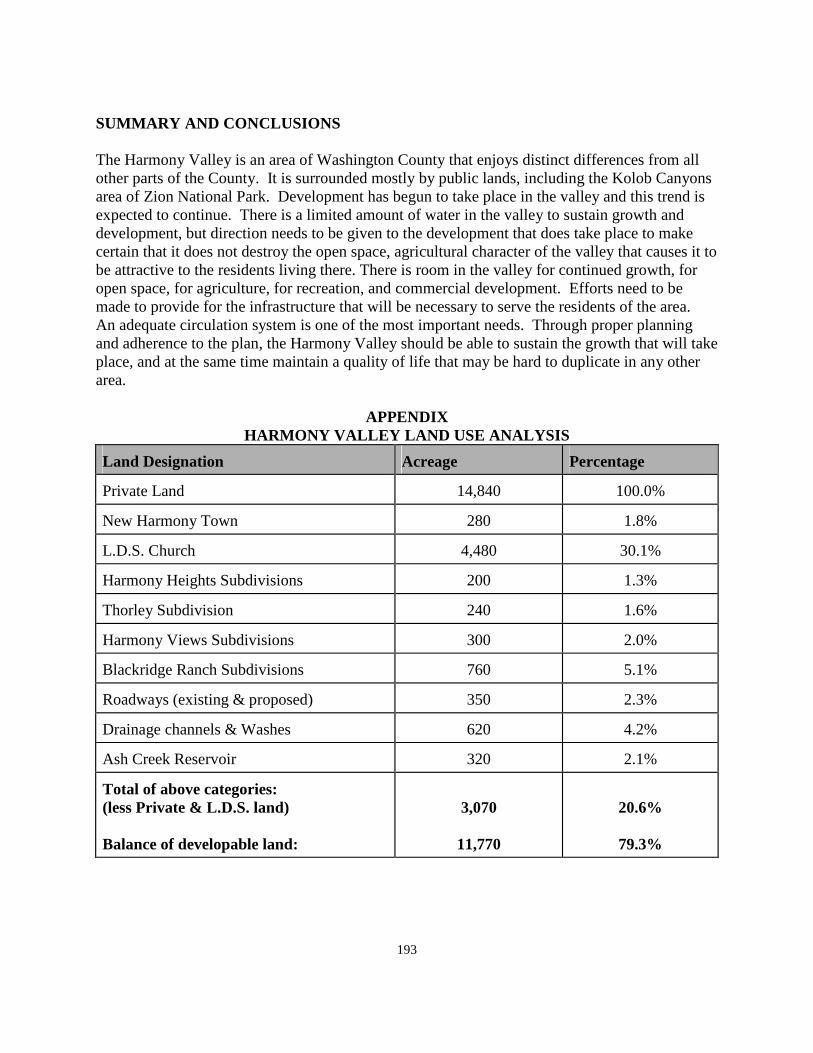
193
SUMMARY AND CONCLUSIONS The Harmony Valley is an area of Washington County that enjoys distinct differences from all other parts of the County. It is surrounded mostly by public lands, including the Kolob Canyons area of Zion National Park. Development has begun to take place in the valley and this trend is expected to continue. There is a limited amount of water in the valley to sustain growth and development, but direction needs to be given to the development that does take place to make certain that it does not destroy the open space, agricultural character of the valley that causes it to be attractive to the residents living there. There is room in the valley for continued growth, for open space, for agriculture, for recreation, and commercial development. Efforts need to be made to provide for the infrastructure that will be necessary to serve the residents of the area. An adequate circulation system is one of the most important needs. Through proper planning and adherence to the plan, the Harmony Valley should be able to sustain the growth that will take place, and at the same time maintain a quality of life that may be hard to duplicate in any other area.
APPENDIX
HARMONY VALLEY LAND USE ANALYSIS
Land Designation Acreage Percentage
Private Land 14,840 100.0%
New Harmony Town 280 1.8%
L.D.S. Church 4,480 30.1%
Harmony Heights Subdivisions 200 1.3%
Thorley Subdivision 240 1.6%
Harmony Views Subdivisions 300 2.0%
Blackridge Ranch Subdivisions 760 5.1%
Roadways (existing & proposed) 350 2.3%
Drainage channels & Washes 620 4.2%
Ash Creek Reservoir 320 2.1%
Total of above categories: (less Private & L.D.S. land) Balance of developable land:
3,070
11,770
20.6%
79.3%
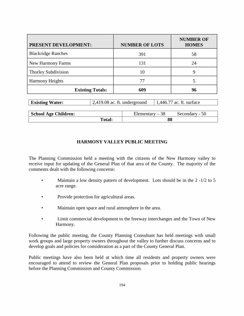
194
PRESENT DEVELOPMENT: NUMBER OF LOTS NUMBER OF
HOMES
Blackridge Ranches 391 58
New Harmony Farms 131 24
Thorley Subdivision 10 9
Harmony Heights 77 5
Existing Totals: 609 96 Existing Water: 2,419.08 ac. ft. underground 1,446.77 ac. ft. surface
School Age Children: Elementary – 38 Secondary - 50 Total: 88
HARMONY VALLEY PUBLIC MEETING The Planning Commission held a meeting with the citizens of the New Harmony valley to receive input for updating of the General Plan of that area of the County. The majority of the comments dealt with the following concerns:
• Maintain a low density pattern of development. Lots should be in the 2 -1/2 to 5 acre range.
• Provide protection for agricultural areas.
• Maintain open space and rural atmosphere in the area.
• Limit commercial development to the freeway interchanges and the Town of New
Harmony. Following the public meeting, the County Planning Consultant has held meetings with small work groups and large property owners throughout the valley to further discuss concerns and to develop goals and policies for consideration as a part of the County General Plan. Public meetings have also been held at which time all residents and property owners were encouraged to attend to review the General Plan proposals prior to holding public hearings before the Planning Commission and County Commission.
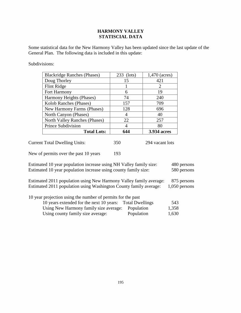
195
HARMONY VALLEY STATISCIAL DATA
Some statistical data for the New Harmony Valley has been updated since the last update of the General Plan. The following data is included in this update: Subdivisions:
Blackridge Ranches (Phases) 233 (lots) 1,470 (acres) Doug Thorley 15 421 Flint Ridge 1 2 Fort Harmony 6 19 Harmony Heights (Phases) 74 240 Kolob Ranches (Phases) 157 709 New Harmony Farms (Phases) 128 696 North Canyon (Phases) 4 40 North Valley Ranches (Phases) 22 257 Prince Subdivision 4 80 Total Lots: 644 3.934 acres
Current Total Dwelling Units: 350 294 vacant lots New of permits over the past 10 years 193 Estimated 10 year population increase using NH Valley family size: 480 persons Estimated 10 year population increase using county family size: 580 persons Estimated 2011 population using New Harmony Valley family average: 875 persons Estimated 2011 population using Washington County family average: 1,050 persons 10 year projection using the number of permits for the past 10 years extended for the next 10 years: Total Dwellings 543 Using New Harmony family size average: Population 1,358 Using county family size average: Population 1,630
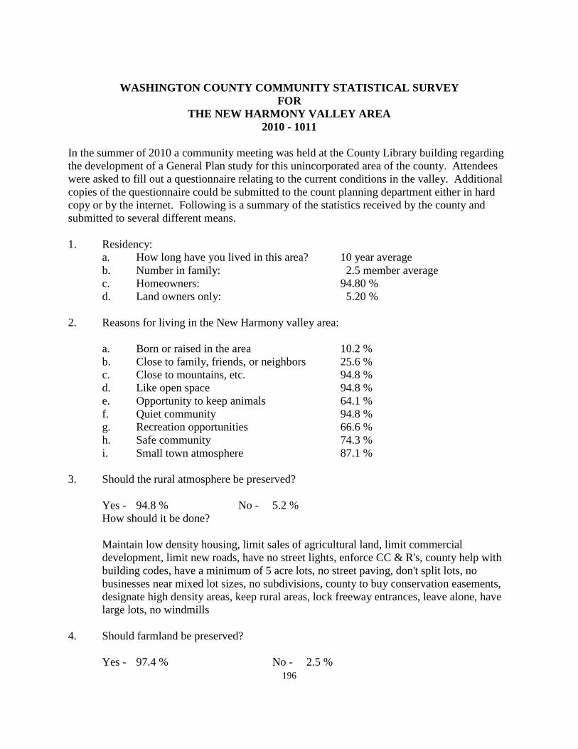
196
WASHINGTON COUNTY COMMUNITY STATISTICAL SURVEY
FOR THE NEW HARMONY VALLEY AREA
2010 - 1011 In the summer of 2010 a community meeting was held at the County Library building regarding the development of a General Plan study for this unincorporated area of the county. Attendees were asked to fill out a questionnaire relating to the current conditions in the valley. Additional copies of the questionnaire could be submitted to the count planning department either in hard copy or by the internet. Following is a summary of the statistics received by the county and submitted to several different means. 1. Residency: a. How long have you lived in this area? 10 year average b. Number in family: 2.5 member average c. Homeowners: 94.80 % d. Land owners only: 5.20 % 2. Reasons for living in the New Harmony valley area: a. Born or raised in the area 10.2 % b. Close to family, friends, or neighbors 25.6 % c. Close to mountains, etc. 94.8 % d. Like open space 94.8 % e. Opportunity to keep animals 64.1 % f. Quiet community 94.8 % g. Recreation opportunities 66.6 % h. Safe community 74.3 % i. Small town atmosphere 87.1 % 3. Should the rural atmosphere be preserved? Yes - 94.8 % No - 5.2 % How should it be done?
Maintain low density housing, limit sales of agricultural land, limit commercial development, limit new roads, have no street lights, enforce CC & R's, county help with building codes, have a minimum of 5 acre lots, no street paving, don't split lots, no businesses near mixed lot sizes, no subdivisions, county to buy conservation easements, designate high density areas, keep rural areas, lock freeway entrances, leave alone, have large lots, no windmills
4. Should farmland be preserved? Yes - 97.4 % No - 2.5 %
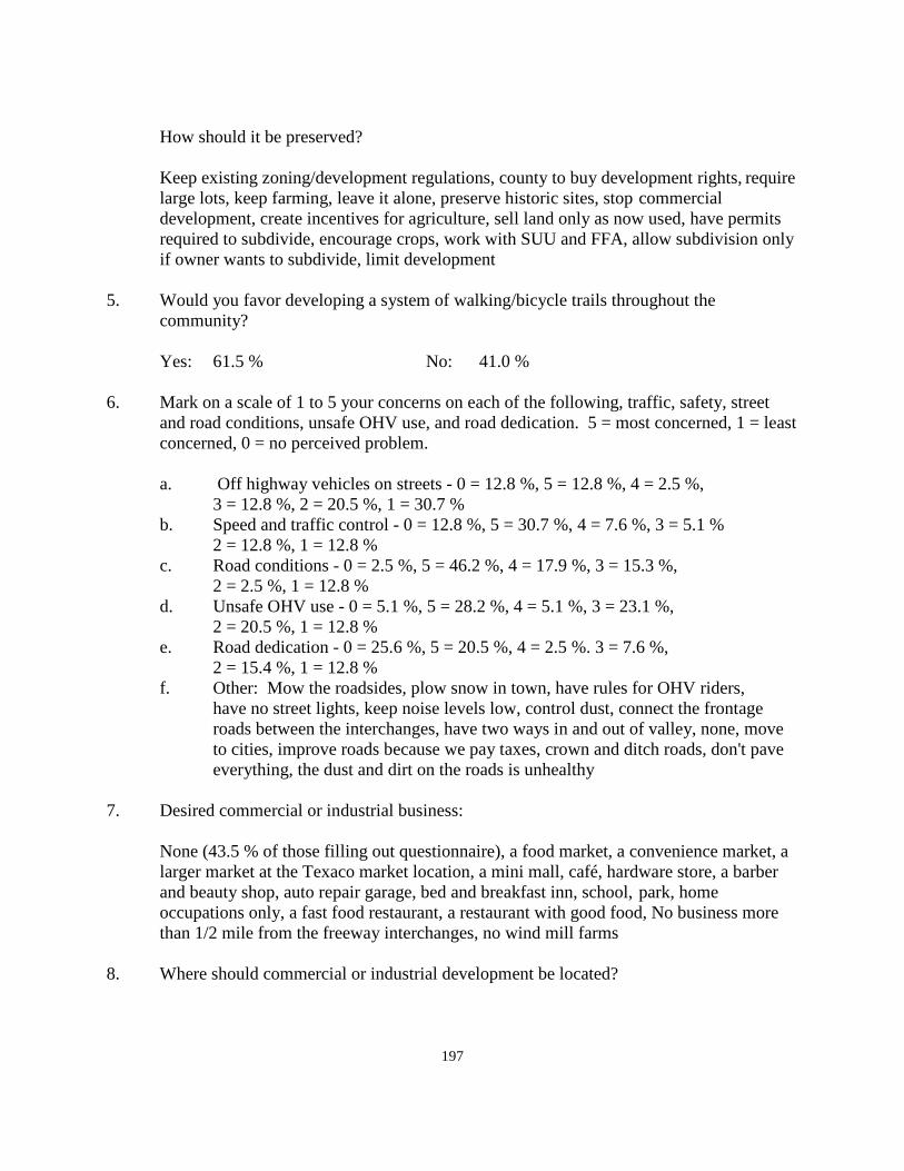
197
How should it be preserved?
Keep existing zoning/development regulations, county to buy development rights, require large lots, keep farming, leave it alone, preserve historic sites, stop commercial development, create incentives for agriculture, sell land only as now used, have permits required to subdivide, encourage crops, work with SUU and FFA, allow subdivision only if owner wants to subdivide, limit development
5. Would you favor developing a system of walking/bicycle trails throughout the community? Yes: 61.5 % No: 41.0 % 6. Mark on a scale of 1 to 5 your concerns on each of the following, traffic, safety, street
and road conditions, unsafe OHV use, and road dedication. 5 = most concerned, 1 = least concerned, 0 = no perceived problem.
a. Off highway vehicles on streets - 0 = 12.8 %, 5 = 12.8 %, 4 = 2.5 %, 3 = 12.8 %, 2 = 20.5 %, 1 = 30.7 % b. Speed and traffic control - 0 = 12.8 %, 5 = 30.7 %, 4 = 7.6 %, 3 = 5.1 % 2 = 12.8 %, 1 = 12.8 % c. Road conditions - 0 = 2.5 %, 5 = 46.2 %, 4 = 17.9 %, 3 = 15.3 %, 2 = 2.5 %, 1 = 12.8 % d. Unsafe OHV use - 0 = 5.1 %, 5 = 28.2 %, 4 = 5.1 %, 3 = 23.1 %, 2 = 20.5 %, 1 = 12.8 % e. Road dedication - 0 = 25.6 %, 5 = 20.5 %, 4 = 2.5 %. 3 = 7.6 %, 2 = 15.4 %, 1 = 12.8 % f. Other: Mow the roadsides, plow snow in town, have rules for OHV riders,
have no street lights, keep noise levels low, control dust, connect the frontage roads between the interchanges, have two ways in and out of valley, none, move to cities, improve roads because we pay taxes, crown and ditch roads, don't pave everything, the dust and dirt on the roads is unhealthy
7. Desired commercial or industrial business:
None (43.5 % of those filling out questionnaire), a food market, a convenience market, a larger market at the Texaco market location, a mini mall, café, hardware store, a barber and beauty shop, auto repair garage, bed and breakfast inn, school, park, home occupations only, a fast food restaurant, a restaurant with good food, No business more than 1/2 mile from the freeway interchanges, no wind mill farms
8. Where should commercial or industrial development be located?
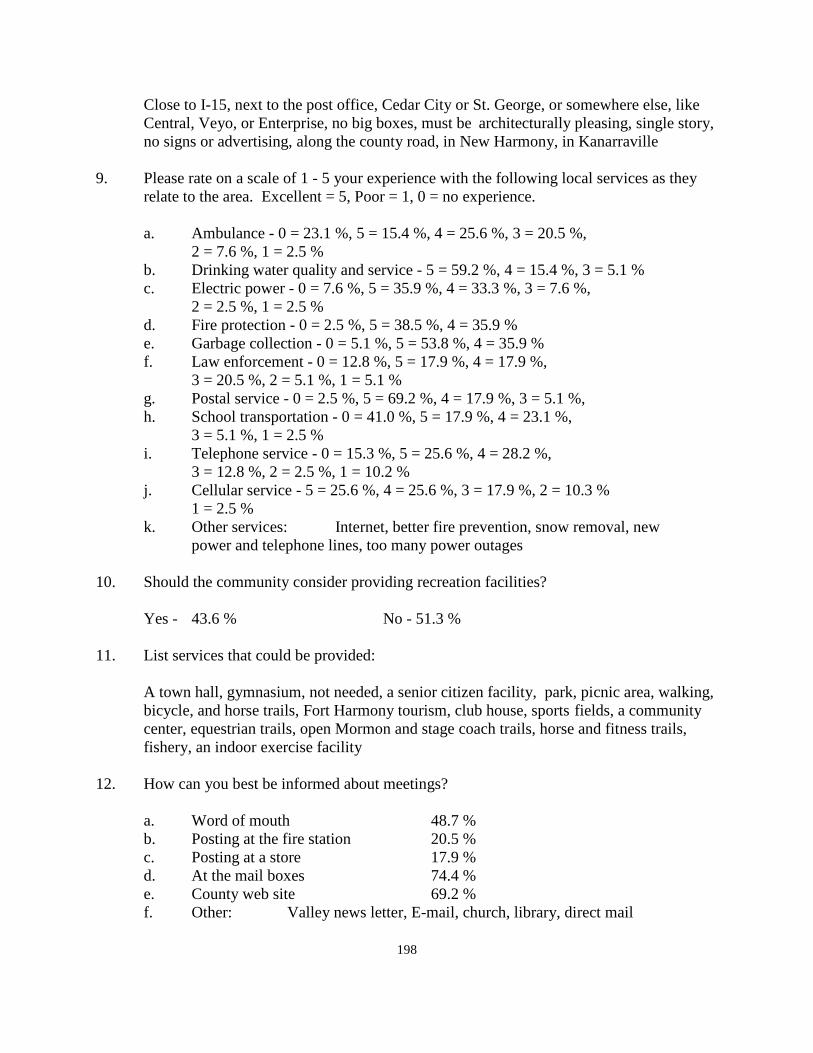
198
Close to I-15, next to the post office, Cedar City or St. George, or somewhere else, like Central, Veyo, or Enterprise, no big boxes, must be architecturally pleasing, single story, no signs or advertising, along the county road, in New Harmony, in Kanarraville
9. Please rate on a scale of 1 - 5 your experience with the following local services as they
relate to the area. Excellent = 5, Poor = 1, 0 = no experience. a. Ambulance - 0 = 23.1 %, 5 = 15.4 %, 4 = 25.6 %, 3 = 20.5 %, 2 = 7.6 %, 1 = 2.5 % b. Drinking water quality and service - 5 = 59.2 %, 4 = 15.4 %, 3 = 5.1 % c. Electric power - 0 = 7.6 %, 5 = 35.9 %, 4 = 33.3 %, 3 = 7.6 %, 2 = 2.5 %, 1 = 2.5 % d. Fire protection - 0 = 2.5 %, 5 = 38.5 %, 4 = 35.9 % e. Garbage collection - 0 = 5.1 %, 5 = 53.8 %, 4 = 35.9 % f. Law enforcement - 0 = 12.8 %, 5 = 17.9 %, 4 = 17.9 %, 3 = 20.5 %, 2 = 5.1 %, 1 = 5.1 % g. Postal service - 0 = 2.5 %, 5 = 69.2 %, 4 = 17.9 %, 3 = 5.1 %, h. School transportation - 0 = 41.0 %, 5 = 17.9 %, 4 = 23.1 %, 3 = 5.1 %, 1 = 2.5 % i. Telephone service - 0 = 15.3 %, 5 = 25.6 %, 4 = 28.2 %, 3 = 12.8 %, 2 = 2.5 %, 1 = 10.2 % j. Cellular service - 5 = 25.6 %, 4 = 25.6 %, 3 = 17.9 %, 2 = 10.3 % 1 = 2.5 % k. Other services: Internet, better fire prevention, snow removal, new power and telephone lines, too many power outages 10. Should the community consider providing recreation facilities? Yes - 43.6 % No - 51.3 % 11. List services that could be provided:
A town hall, gymnasium, not needed, a senior citizen facility, park, picnic area, walking, bicycle, and horse trails, Fort Harmony tourism, club house, sports fields, a community center, equestrian trails, open Mormon and stage coach trails, horse and fitness trails, fishery, an indoor exercise facility
12. How can you best be informed about meetings? a. Word of mouth 48.7 % b. Posting at the fire station 20.5 % c. Posting at a store 17.9 % d. At the mail boxes 74.4 % e. County web site 69.2 % f. Other: Valley news letter, E-mail, church, library, direct mail
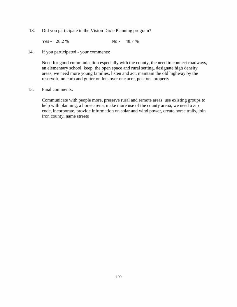
199
13. Did you participate in the Vision Dixie Planning program? Yes - 28.2 % No - 48.7 % 14. If you participated - your comments:
Need for good communication especially with the county, the need to connect roadways, an elementary school, keep the open space and rural setting, designate high density areas, we need more young families, listen and act, maintain the old highway by the reservoir, no curb and gutter on lots over one acre, post on property
15. Final comments:
Communicate with people more, preserve rural and remote areas, use existing groups to help with planning, a horse arena, make more use of the county arena, we need a zip code, incorporate, provide information on solar and wind power, create horse trails, join Iron county, name streets
200
WASHINGTON COUNTY COMMUNITY SURVEY ANALYSIS FOR
THE HARMONY VALLEY AREA 2010-2011
At a meeting in the Harmony Valley in the summer of 2010, it was indicated that the county was going to update the General Plan of the Harmony Valley. A questionnaire was filled out and has been tabulated by the county. Following is a brief analysis of the information from the questionnaire. After reviewing the material in the questionnaire it became very apparent that there is a certain amount of misunderstanding relative to several issues facing this valley and the other unincorporated areas in the county. These issues are discussed as follows: 1. I-15 frontage roads:
On the east side of I-15 at the New Harmony exit there is a small subdivision located there. The main north-south road in the subdivision dead ends at the southern end of the subdivision. The property from this point to the Kolob Canyon interchange is owned by the National Park Service. Many years ago, they were approached, through the Park Superintendent, about the possibility of opening a road through the National Park to connect the road on the north with the interchange to the south. The county found out that would require an act of Congress to authorize a road to be opened up through the National Park. As a result, it never happened.
Depending upon the makeup the Presidency and Congress following the 2012 election, it may be possible to have the Congressional Representative from this area to propose a bill in congress to allow such a road to be constructed.
On the westerly side of 1-15 along the west side of the land that was once owned by Mr. Anderson, there is a 50' right-of-way across this land. South of that property the land is owned by the LDS Church. There is another parcel of private property between the LDS land and the Kolob Canyon Interchange.
2. Connection between Kolob Canyon Interchange and New Harmony Town:
Some years ago the LDS Church, the majority land owner on the New Harmony Bench, started developing their property, primarily areas fronting the county road between the I-15 freeway and the Town of New Harmony. At that time, the church and the county were very close to being able to open the road through the LDS Church land. When the decision was made by the church to return to livestock production and to cancel development for a time, they did not favor opening the road because of the problems it would create for grazing livestock in the area of the roadway. At such time as they once again begin developing, that road should be able to be opened and used.
201
The road itself is not a main highway. It is however an existing roadway and is very easy to travel in an automobile. While not being a high speed highway and a straight road such as the road from I-15 to New Harmony Town, it is a good road, readily passable, and a very scenic drive between the two areas. The county is not prepared to condemn the property, fence the entire right-of-way, and improve the road condition by paving it.
This will happen at some future time, but it will be determined by the future decision of the LDS Church. In addition, the road going south from the county library should be extended across the Church land and tie into the New Harmony to the Kolob interchange road.
3. Road improvements:
In Washington County roads are improved and maintained in two ways. One way is for the improvements to be installed at the time the subdivision is approved by the county. The county standards have changed many times over past years. At one time, no specific improvements were required. A developer could tell the county that no one wanted paved roads and therefore the roads were not paved. This worked well until the first home was built and the cars going by created dust. Then the homeowner wished that the roads were paved. Homeowners did not pay for paved roads when they bought their lots. They actually paid for the amount of road improvement that is in the subdivision in which they live.
Washington County does not use property taxes for road maintenance. The county receives money each year from the State of Utah that is collected in the form of gasoline tax. This amount changes each year and forms the basis for maintenance of all county roads. Last year, the General Fund or Washington County received approximately five cents for every dollar of taxes paid. This represents the lowest general fund tax of all twenty-nine counties in the State.
The position of the county for several decades has been to maintain the county roads in the same condition as they are in at the time the subdivision plats are recorded. It is not uncommon for residents in subdivision in the county to desire to have their roads paved or otherwise improved. The county is willing to create special improvement districts to improve roads in any area where the residents would like them improved. By creating an improvement district, the cost of the improvement can be spread over a period of time, usually about ten years. This method of improvement is available if the residents are in favor of doing so. Otherwise, the county will continue to maintain the roads in the condition they were in at the time of subdivision approval.
Roads with "borrow ditches" along each side have become a major maintenance problem in the county. It would require to men, a dump truck, and a back hoe to work full time to maintain all of the culverts crossing borrow ditches into individual lots to keep them cleaned out and working. Further, property owners frequently landscape their lots out to the edge of the travel way by placing large rocks, etc, in the county right-of-way. These
202
objects create a significant problem for the county to remove materials that may cause traffic problems. It is easier to maintain curb and gutter.
Residency and family size: The average resident in the Harmony Valley has lived here approximately ten years. The interesting thing is to notice the average family size which is about 2.5 residents per dwelling. The county average is out 3 residents per family. This lower number would tend to indicate that there are many seasonal residents in the area and many retired residents who live here either part time of full time.
Reasons for living in the Harmony Valley:
There were a number of reasons given for living in this area. The highest number mentioned were being close to the mountains, or liking the open space of the area. A quiet community was also rated high as a reason for living in this valley. It is also considered to be a safe community.
Should the rural character be preserved? Over 90 % of those responding to the questionnaire would like to preserve the rural atmosphere. Many reasons were given as suggestions as to how to maintain these qualities that are strongly supported by residents. Their suggestions include some of the following: Maintain low density housing, limit sales of agricultural land, limit commercial development, limit new roads, have no street lights, enforce CC& R's, no street paving, designate high density areas, don't allow lot splits, no new subdivisions, county to buy conservations easements, lock the freeway entrances, leave things alone, no windmills.
Some of these suggestions may be good suggestions for the future of the valley, but have little to do with maintaining the rural character. Large lot sizes will work. The county has no way to limit the sale of agricultural land or whether someone continues to farm or not. The county does not currently require street lights in new subdivisions. The county does not enforce conditions, covenants and restrictions (CC& R's). It is the responsibility of individual home owners, or associations to enforce this type of restriction.
Conservation easements are a good way to preserve various types of open space land. However the county does not have tax money to spend buying such rights. There are various entities that do purchase conservation easements that residents of the area could look into. The county has been a recipient of the purchase of conservation easements. Locking the freeway exits may be a good way to keep new residents out, but it may make it hard for residents to come and go as they would like.
Should farm land be preserved?
Over 97 % of the residents filling out questionnaires were in favor of preserving the farm land in the valley. Comments on the county buying development rights were discussed in the
203
previous section relating to maintaining the rural character of the valley. Whether or not to work with SUU (Southern Utah University) or FFA (Future Farmers of America) are decisions that would need to be left up to existing farmers to decide. There are presently methods of protecting agricultural land including the Green Belt legislation which protects the farmer from increases in land value until such time as the land is sold. There is also legislation for Farmland Protection to allow farmers to continue farming when neighbors may be upset with some farming practices.
Walking and bicycle trails:
A majority of those filling out the questionnaires were in favor of developing bicycle and walking trails in the valley. There was also interest in including equestrian (horseback riding) as a part of any such trails that might be developed. However a significant number of people also were not in favor of trails and indicated that the present road system was adequate for these purposes.
Concerns about traffic safety, street and road conditions, unsafe OHV use, and street dedication:
There was not any particular concern raised about the use of OHV use. Speed was indicated as a concern by about 1/3 of the respondents. Road conditions were discussed at the beginning of this analysis. Unsafe OHV use does not appear to be a serious problem in the area. Some concern was raised about road dedication. None of these issues, except concerns about roads, was raised to a serious concern level.
Desired commercial or industrial business:
Almost half of the respondents to the questionnaire indicated that there was no place in the valley for further commercial or industrial development. On the other hand, about the same number indicated the types of commercial development that they felt would be of benefit to the area. These things are listed in the statistical survey under # 7 of that document. At least one respondent indicated, with a good sense of humor, that any commercial development should be located in Enterprise, Central, or Veyo.
Public Services:
A number of public services in the valley were identified with a response as to concerns that may exist with the various services provided.
Several services received high ratings. These services include Drinking water quality and service, garbage collection, and postal service. Moderate and acceptable ratings were given to services including electric power, and fire protection. Receiving the lowest ratings were services such as law enforcement, school transportation, telephone and cellular service. It should be noted however, that ambulance service and school transportation had a high rating of those who expressed little or no experience with the services. In other words, they had not used ambulance service and had no children riding a school bus.
204
In addition to the services listed in the questionnaire, there were several services mentioned that were provided but which could be improved. These included internet service, better fire prevention, snow removal and new power and telephone lines.
Should the area provide recreation facilities?
The majority of respondents by a slim margin indicated No, Slightly less than half of those responding indicated yes and then went on to list a number of different facilities that they would like to see in this area.
How to best inform residents of public meetings:
The first choice is by listing meetings at the mail boxes. Posting on the county web site was also highly supported. Other sources suggested include including meetings in the local valley news letter which would be a very good suggestion, at the church, library, and by direct mail. Direct mail is probably not an option for the county to use simply because of the cost involved if this method was used on a county-wide basis.
Regarding the Vision Dixie Planning Project, about 1/4 of the respondents indicated that they attended the meeting held in this area. About twice this many residents did not participate in the study. From those who did participate, a number of suggestions were made in the statistical review of some things that they would like to see happen.
The final question in the questionnaire was to indicate any other things that should be considered relative to the New Harmony Valley area. These are also listed in the statistical summary. Some of these items have been discussed in this section of the study. Others may be identified in the General Plan report.

205
KOLOB AREA GENERAL PLAN 2010 - 2011
Introduction: In 2010 Washington County undertook the development of a General Plan for each of the thirteen unincorporated community areas in Washington County. The Kolob area of the county is one of the unincorporated areas containing many dwelling units even though there are currently no year-around residents of the area. The Kolob mountain portion of the county provides summer residences for many residents of the county as well as for many of the residents of southern Nevada, including Clark County and the Las Vegas area. During the summer months, the Kolob area of the county has many residents at any particular point in time. Kolob is identified as a viable part of Washington County, and has therefore been identified as one of the unincorporated areas of the county where a plan should be prepared. This part of the county has developed over a long period of time and has always seemed to be slightly dis-organized. This may be because the development has been scattered over a large distance without much unity between the various developments that have taken place. Geography and Topography: Kolob is located in the northeast corner of Washington County. The area comprises some 59,003 acres, or 92.2 square miles of the county. Kolob represents the largest single block of private land in the county. The elevation of the Kolob area is approximately 8,000 feet above sea level. The area is bounded by Iron County to the north, Kane County to the East and Zion National Park to the south and west. The major access to Kolob is from a roadway from the town of Virgin along State Highway 9. This road traverses some parcels of private land, and a large portion of the National Park, essentially terminating at the Kolob Reservoir which is located near the southern part of the valley. At 8,000 feet elevation, Kolob definitely has a four season climate. In fact, the winter season is rather long. The main road to Kolob is closed by the National Park at the north end of the Park boundary when the snow season begins and is not opened again until late spring. Snowfall at Kolob is often eight to ten feet deep. The only access during the winter months is by snowmobile. At least one development made an effort to stay open year-around one winter, but has since closed during the winter and early spring months. No one makes the area their home on a year around basis. This makes Kolob a somewhat isolated area as a part of Washington County which is known for mild winters and warm winter temperatures.
206
Historical Background: Washington County was first settled in 1852 with the construction of a fort in the Harmony Valley. The original county seat of the county was at Fort Harmony near the Iron County line. Later, development spread to the southern valleys of the county and St. George became the eventual county seat. The eastern part of the county was originally in the western part of what is now Kane County. The lower valleys of the county were settled for the purpose of growing cotton during the years of the Civil War when cotton products were not available in the Utah area. The first settlements included Swiss settlers in the Santa Clara area and other settlers in the area of Washington City. The original cotton mill, built to process cotton products is still located in the City of Washington. Early settlement of the county was closely tied to the Agricultural industry and many of the early settlers were involved in the livestock business. There were several large herds of livestock and sheep in the early days of the county. The search for grazing land for these animals during the summer months led to the acquisition of land holdings in the Kolob area many years before Zion National Park was created. At least one of these livestock producers tells that they could winter their herd in what is now part of the City of Hurricane, and trail their animals in the summer to Kolob without ever leaving their own land. They are still among the large land holders in the Kolob area that still graze livestock there during the summer months. Land Use: Open Space Development: Open space, livestock grazing, and wilderness areas The majority of the Kolob area is undeveloped. In the county it is classed as undeveloped open space. While much of the area is not developed in any urban manner, it is used for livestock grazing. The advantage in the Kolob area for livestock grazing, as opposed grazing in other parts of the county where the land is managed by a Federal agency, is the fact that it is nearly all privately owned land. This means that the Federal Government cannot continue to cut back on the number of animals that can be grazed on an individual property. It is up to the land owner to manage grazing to protect the capability of the land to continue grazing. The General Plan supports livestock grazing in Washington County and recommends that this practice be encouraged to continue in the Kolob area. When the 2009 Washington County Land Bill was approved by Congress and the President, much of the existing BLM land in the Kolob area was included as wilderness area as was most of Zion National Park. In the entire county there were fifteen wilderness areas that were identified and approved by Congress. Of these fifteen wilderness areas, six are located in the Kolob area. A complete detail of each of the wilderness areas is found in Appendix I of the County General Plan adopted in October, 2010. In this section of the General Plan, only those wilderness areas
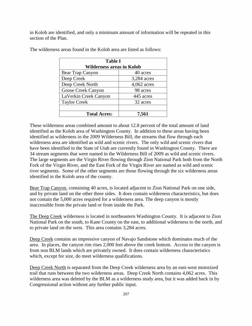
207
in Kolob are identified, and only a minimum amount of information will be repeated in this section of the Plan. The wilderness areas found in the Kolob area are listed as follows:
Table I Wilderness areas in Kolob
Bear Trap Canyon 40 acres Deep Creek 3,284 acres Deep Creek North 4,062 acres Goose Creek Canyon 98 acres LaVerkin Creek Canyon 445 acres Taylor Creek 32 acres Total Acres: 7,561
These wilderness areas combined amount to about 12.8 percent of the total amount of land identified as the Kolob area of Washington County. In addition to these areas having been identified as wilderness in the 2009 Wilderness Bill, the streams that flow through each wilderness area are identified as wild and scenic rivers. The only wild and scenic rivers that have been identified in the State of Utah are currently found in Washington County. There are 34 stream segments that were named in the Wilderness Bill of 2009 as wild and scenic rivers. The large segments are the Virgin River flowing through Zion National Park both from the North Fork of the Virgin River, and the East Fork of the Virgin River are named as wild and scenic river segments. Some of the other segments are those flowing through the six wilderness areas identified in the Kolob area of the county. Bear Trap Canyon, containing 40 acres, is located adjacent to Zion National Park on one side, and by private land on the other three sides. It does contain wilderness characteristics, but does not contain the 5,000 acres required for a wilderness area. The deep canyon is mostly inaccessible from the private land or from inside the Park. The Deep Creek wilderness is located in northeastern Washington County. It is adjacent to Zion National Park on the south, to Kane County on the east, to additional wilderness to the north, and to private land on the west. This area contains 3,284 acres. Deep Creek contains an impressive canyon of Navajo Sandstone which dominates much of the area. In places, the canyon rim rises 2,000 feet above the creek bottom. Access to the canyon is from non BLM lands which are privately owned. It does contain wilderness characteristics which, except for size, do meet wilderness qualifications. Deep Creek North is separated from the Deep Creek wilderness area by an east-west motorized trail that runs between the two wilderness areas. Deep Creek North contains 4,062 acres. This wilderness area was deleted by the BLM as a wilderness study area, but it was added back in by Congressional action without any further public input.
208
Deep Creek North is similar in many ways to Deep Creek south. It is essentially surrounded by private land making access difficult. One reason that the BLM deleted this wilderness study area from further consideration was the evidence of man that can be seen from within the wilderness and the inaccessibility by the general public without trespassing on private property. Goose Creek Canyon is adjacent to Zion National Park on the south and to private land on the other three sides. Goose Creek Canyon contains 98 acres. This parcel is isolated from other BLM lands. The canyon rims are 2000 feet above the canyon floor. The only access to the canyon is through Zion National Park. Goose Creek Canyon does contain wilderness characteristics but does not contain sufficient acres to qualify, by itself, as a wilderness area. LaVerkin Creek Canyon is one of the larger of the Kolob wilderness areas and contains 445 acres. It is bounded by Zion National Park on the south and by private land on the other sides. It contains 1.5 miles of LaVerkin Creek and a very small part of the Bear Trap Canyon drainage. It is basically an "L" shaped wilderness area. The area is in a natural condition and offers opportunity for hiking, back packing, horseback riding and photography. Along with the National Park, it does offer opportunities for solitude through its entire area. Taylor Creek Canyon is the smallest of the Kolob wilderness areas. It contains only 32 acres. The area is dominated by rugged, barren slick rock terrain found at the head of a deep drainage, the middle fork of Taylor Creek. The majority of the canyon is within the National Park that is adjacent to Taylor Creek Canyon. High cliffs prohibit access from this wilderness area into Zion National Park. It has natural qualities and other wilderness characteristics, but it lacks the size requirement normally expected for wilderness areas as do all of the other Kolob wilderness designations. Residential Development: Residential development did not begin to take place until 1961 when the first subdivision plat was recorded. There were scattered livestock management cabins scattered throughout the area in early years, but no residential subdivisions were recorded prior to 1961. Following is a list of the subdivisions that have been recorded in the Kolob area along with the number of lots in each subdivision. Many of these developments have been developed in phases with the date of the first phase being listed.
Table II. Subdivisions, # of lots, acres and date of recording
1. Bastion Woodlands 1 lot 5.00 acres 10-31-88 2. Graceful Acres 96 lots 192.77 acres 06-30-72 3. Home Valley Park 29 lots 193.46 acres 04-13-70 4. Kolob Acres 26 lots unknown 09-16-61
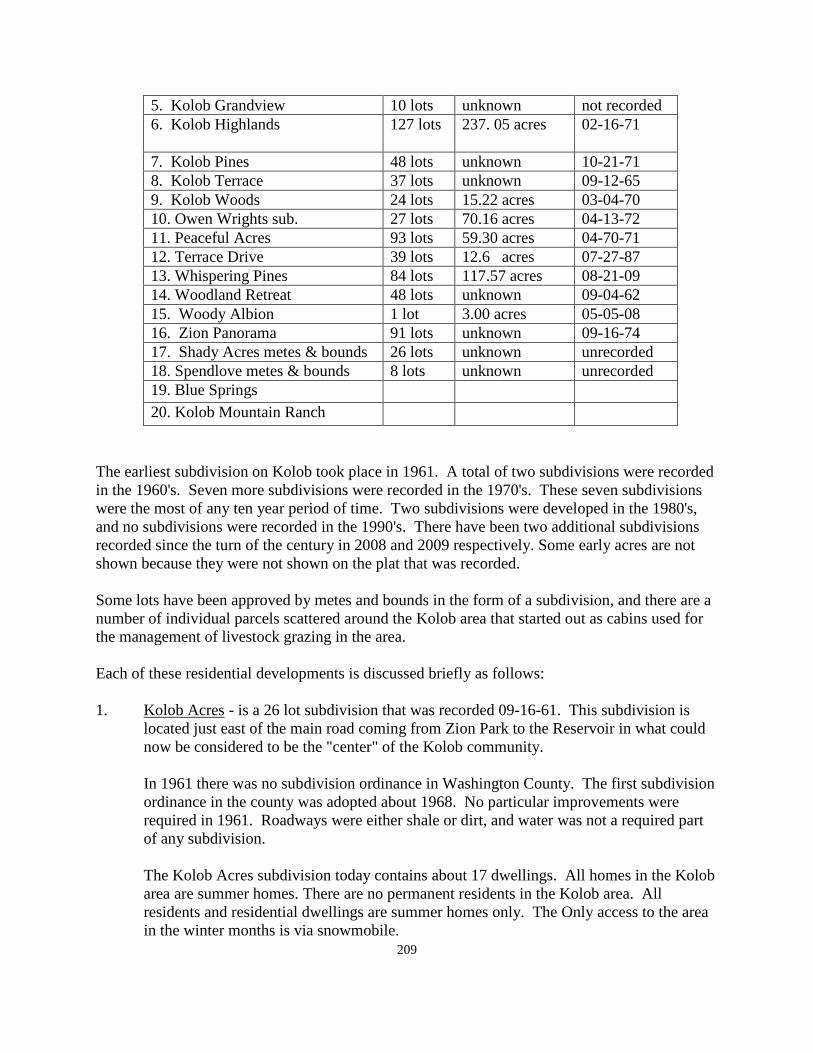
209
5. Kolob Grandview 10 lots unknown not recorded 6. Kolob Highlands 127 lots
237. 05 acres 02-16-71
7. Kolob Pines 48 lots unknown 10-21-71 8. Kolob Terrace 37 lots unknown 09-12-65 9. Kolob Woods 24 lots 15.22 acres 03-04-70 10. Owen Wrights sub. 27 lots 70.16 acres 04-13-72 11. Peaceful Acres 93 lots 59.30 acres 04-70-71 12. Terrace Drive 39 lots 12.6 acres 07-27-87 13. Whispering Pines 84 lots 117.57 acres 08-21-09 14. Woodland Retreat 48 lots unknown 09-04-62 15. Woody Albion 1 lot 3.00 acres 05-05-08 16. Zion Panorama 91 lots unknown 09-16-74 17. Shady Acres metes & bounds 26 lots unknown unrecorded 18. Spendlove metes & bounds 8 lots unknown unrecorded 19. Blue Springs 20. Kolob Mountain Ranch
The earliest subdivision on Kolob took place in 1961. A total of two subdivisions were recorded in the 1960's. Seven more subdivisions were recorded in the 1970's. These seven subdivisions were the most of any ten year period of time. Two subdivisions were developed in the 1980's, and no subdivisions were recorded in the 1990's. There have been two additional subdivisions recorded since the turn of the century in 2008 and 2009 respectively. Some early acres are not shown because they were not shown on the plat that was recorded. Some lots have been approved by metes and bounds in the form of a subdivision, and there are a number of individual parcels scattered around the Kolob area that started out as cabins used for the management of livestock grazing in the area. Each of these residential developments is discussed briefly as follows: 1. Kolob Acres - is a 26 lot subdivision that was recorded 09-16-61. This subdivision is
located just east of the main road coming from Zion Park to the Reservoir in what could now be considered to be the "center" of the Kolob community.
In 1961 there was no subdivision ordinance in Washington County. The first subdivision ordinance in the county was adopted about 1968. No particular improvements were required in 1961. Roadways were either shale or dirt, and water was not a required part of any subdivision.
The Kolob Acres subdivision today contains about 17 dwellings. All homes in the Kolob area are summer homes. There are no permanent residents in the Kolob area. All residents and residential dwellings are summer homes only. The Only access to the area in the winter months is via snowmobile.
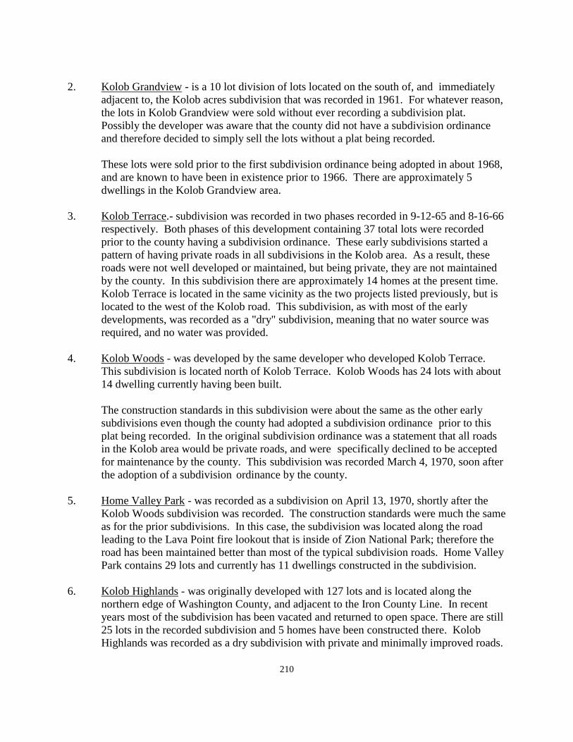
210
2. Kolob Grandview - is a 10 lot division of lots located on the south of, and immediately
adjacent to, the Kolob acres subdivision that was recorded in 1961. For whatever reason, the lots in Kolob Grandview were sold without ever recording a subdivision plat. Possibly the developer was aware that the county did not have a subdivision ordinance and therefore decided to simply sell the lots without a plat being recorded.
These lots were sold prior to the first subdivision ordinance being adopted in about 1968, and are known to have been in existence prior to 1966. There are approximately 5 dwellings in the Kolob Grandview area.
3. Kolob Terrace.- subdivision was recorded in two phases recorded in 9-12-65 and 8-16-66
respectively. Both phases of this development containing 37 total lots were recorded prior to the county having a subdivision ordinance. These early subdivisions started a pattern of having private roads in all subdivisions in the Kolob area. As a result, these roads were not well developed or maintained, but being private, they are not maintained by the county. In this subdivision there are approximately 14 homes at the present time. Kolob Terrace is located in the same vicinity as the two projects listed previously, but is located to the west of the Kolob road. This subdivision, as with most of the early developments, was recorded as a "dry" subdivision, meaning that no water source was required, and no water was provided.
4. Kolob Woods - was developed by the same developer who developed Kolob Terrace.
This subdivision is located north of Kolob Terrace. Kolob Woods has 24 lots with about 14 dwelling currently having been built.
The construction standards in this subdivision were about the same as the other early subdivisions even though the county had adopted a subdivision ordinance prior to this plat being recorded. In the original subdivision ordinance was a statement that all roads in the Kolob area would be private roads, and were specifically declined to be accepted for maintenance by the county. This subdivision was recorded March 4, 1970, soon after the adoption of a subdivision ordinance by the county.
5. Home Valley Park - was recorded as a subdivision on April 13, 1970, shortly after the
Kolob Woods subdivision was recorded. The construction standards were much the same as for the prior subdivisions. In this case, the subdivision was located along the road leading to the Lava Point fire lookout that is inside of Zion National Park; therefore the road has been maintained better than most of the typical subdivision roads. Home Valley Park contains 29 lots and currently has 11 dwellings constructed in the subdivision.
6. Kolob Highlands - was originally developed with 127 lots and is located along the
northern edge of Washington County, and adjacent to the Iron County Line. In recent years most of the subdivision has been vacated and returned to open space. There are still 25 lots in the recorded subdivision and 5 homes have been constructed there. Kolob Highlands was recorded as a dry subdivision with private and minimally improved roads.
211
7. Peaceful Acres - is a 93 lot development located adjacent to the north of the Terrace Drive subdivision. It filled much of the "gap" between Terrace Drive and Kolob Wood subdivisions. This subdivision was recorded on April 20, 1971. Since its original development, some of the lots in this subdivision have been provided with some water connections from water in adjacent subdivisions or other housing projects. There are 19 dwellings in the subdivision.
8. Kolob Pines - is a subdivision located a significant distance to the east of the cluster of
subdivisions located adjacent to the Kolob Reservoir Road. The subdivision contains 47 lots and currently has about 17 dwellings in the subdivision. It was recorded in two phases on 10-21-71 and 10-3-72. The roadways are also private.
9. Woodland Retreat - is a subdivision located in the center part of the Kolob area just a
short distance east of the Kolob Reservoir Road. The development includes 48 lots and there are currently about 28 dwellings constructed in the subdivision. Woodland Retreat was recorded on September 25, 1962. There was no county subdivision ordinance in 1962.
10. Owen Wright subdivision - is located north of the "center" of the Kolob area
development, immediately adjacent to the Kolob Reservoir Road. The Kolob Reservoir Road is the main roadway coming from the Town of Virgin, north through Zion National Park to the Kolob Reservoir. It is paved and dedicated through the Kolob area between the Park Boundary the Reservoir.
Owen Wright developed this subdivision and recorded the county approved plat on April 13, 1972. The subdivision contains 27 lots and 9 residential dwellings have currently been constructed there. Other conditions in the subdivision are much the same as in all those subdivisions previously identified herein.
11. Graceful Acres - is another subdivision located adjacent to the Kolob Pines subdivision
and contains 96 lots. It was recorded June 30, 1972. The subdivision is much like the other early subdivisions in the area. The roads are sometimes difficult to traverse because of their location and the manner in which they were constructed. There are currently only two dwellings in the subdivision.
12. Terrace Drive - is a 39 lot subdivision located east of Peaceful Acres and has access from
the Kolob Reservoir Road. There are currently 14 dwelling units in the subdivision. This subdivision is one that has provided some water connections to the subdivisions located to the west of this project. Terrace Drive is one of the few subdivisions that have water available to the lots in the subdivision. Terrace Drive was recorded July 27, 1987, and is therefore one of the more recent subdivisions in the Kolob area.
13. Zion Panorama - is a subdivision located in the far eastern part of the Kolob area not too
far from the Kane County line. This subdivision was recorded in several phases beginning with phase 1 on September 16, 1974. The subdivision contains 91 lots. There
212
are about 34 dwelling units currently constructed in Zion Panorama. This development is further away from the "center" of the valley than any other of the Kolob subdivisions.
14. Bastion Woodlands - is a five acre, one lot subdivision recorded on October 32, 1988. It
is located in the area of Kolob Pines, and Graceful Acres. It contains one dwelling unit which was the purpose for which the development was created.
15. Woody Albion - is a three acre, one lot subdivision located adjacent to the Bastion
Woodlands one lot subdivision. It contains one residential dwelling which was the purpose for which the one lot subdivision was created.
16. Whispering Pines - contains 84 lots and is located along the Kolob Reservoir Road on the
west side of the main road. Whispering Pines is a new subdivision that was recorded on August 21, 2009. The subdivision currently contains one dwelling. This subdivision continues the county policy of not accepting subdivision roads in the county for county maintenance. It is also the only subdivision that contains paved roads. Paved roads are now required in all subdivisions in Washington County no matter what part of the county they are located in.
17. Shady Acres - is an area located between Kolob Woods and Peaceful acres. It is a group
of lots that were sold off by metes and bounds without ever being included as part of a subdivision plat. There are 26 lots in this area and there have been approximately 11 dwellings built in this area.
18 Spendlove metes and bounds - includes a group of about 18 lots that were approved by
metes and bounds without recording a subdivision plat. There appears to be 8 dwelling units built in this area. This development is located south of Kolob Highlands and east of the Kolob Reservoir. There are no other subdivisions located in the general area of this group of properties.
19. Blue Springs Recreation Area - is a planned development that was created in the early
1960's before the county had either a subdivision ordinance or a planned development zone in the zoning ordinance. The site contains a reservoir covering 35 acres of land. There are 30 building lots in the project of 1 acre each. An additional 12 to 14 building sites have been identified since the original plan was prepared. These additional sites that have been sold are no longer part of the recreation area. The Blue Springs Recreation Area is available for use by owners and guests of owners.
20. Kolob Mountain Ranch - was a residential lodge development that commenced with the
first phase being developed in 1988. Phase I contained 12 rooms with two other phased being added later on. The intent of the project was to have residential facilities available for rent, or ownership on a time share basis. These facilities were clustered together in close proximity on a 600 acre parcel of land. The project also included a water system with a large storage facility. Some water was also provided to some adjacent lots that were originally approved as dry subdivision lots.
213
The intent of the development was to allow residents and guests to spend time in a clustered setting with common indoor areas, and to have outdoor access to most of the 600 acre site for outdoor recreation including hiking, horseback riding, etc., without ever leaving the 600 acre commonly owned property.
At one point, an effort was made to keep the resort open through the winter months. This proved to be difficult to do because of the difficulty of access, the lack of snow removal on roadways, and the isolation of the lodge during winter months. During the summer season, it is a desirable location.
21. Scattered parcels - There are other scattered dwelling units on parcels of privately owned
land that exist in various areas of Kolob. Because of the size of most of the many privately owned parcels of land, permits can be obtained for dwellings on this land without the need for recording a specific subdivision plat.
There are a total of about 230 dwellings in subdivisions and metes and bounds projects, along with about 30 to 40 scattered parcels throughout the area. The total number of dwellings in the Kolob area is about 260 to 270 dwellings. The summer population in the area could be as high as about 800 persons on any given day, particularly during holiday week-ends. Commercial Development: There is a very minimal amount of commercial development on Kolob. Years ago, a restaurant was constructed just off of the Reservoir Road. It was not successful and closed down after a short run. Following this facility, a store occupied the building for a time, and then it also went out of business. Some additional land along the reservoir road has been zoned for commercial development when a request was made to establish a commercial business in a dwelling that is located along the road. None of these efforts was successful. Most recently, the original restaurant business has again been remodeled and opened for a commercial store business. The General Plan supports commercial development in the Kolob area, and the areas presently zone for commercial use are in the proper location to fill that need as it expands. The problem at this time with commercial development in the Kolob area is the fact that commercial development is dependent upon a perceived need of the public for commercial business. That need may be difficult to identify in an area that is limited to just a few months each year in which to bring a return on the investment. Recreation: One reason for the development in Kolob is for the purpose of providing summer season recreation opportunities for those having property and homes there. The location, low density pattern of development, fresh air, cool summer temperatures, and a beautiful night sky are all reasons for the success of residential development projects in this area. Those purposes will
214
continue to grow and develop in coming years, and certainly there is sufficient space for more development to take place. The major recreation facility in the area is the Kolob Reservoir and the land surrounding the reservoir. Originally, the reservoir was created for water storage for agricultural purposes in the lower valleys of Washington County. Recreational use of the site was not part of the original proposal. Iron County (Cedar City) also maintained an interest in the reservoir and later determined that it was not economically feasible to transport the water from the reservoir into Iron County. Following the pull-out from Iron County, the Hurricane Irrigation Company, originally developers of the reservoir, turned the site over to the Washington County Water Conservancy District for management and maintenance purposes. Early on, the Conservancy District organized a committed to study the future use of the reservoir and to oversee the preparation of a long range plan for future development. This study was carried out during the summer of 1996 and completed in November of that year. The main need identified in the report was to provide sanitary facilities for use by those using the reservoir for recreation purposes. Kolob Reservoir had become a popular fishing site with help from the State in stocking the reservoir with fish. During some periods of time it has been a "catch and release" reservoir as opposed to keeping the fish that were caught. An additional facility constructed early on by the District was a boat ramp to allow fishing craft to be launched into the reservoir in one place as opposed to random launching around the reservoir. These early needs have been completed. The original plan for the reservoir called for the development of a number of camp sites at various points around the reservoir. Ninety two sites were identified, staked out on the ground, and surveyed into a development plan. There were an additional fifteen sites identified as day-use only sites. There were also two sites at each end of the reservoir that were identified as group use areas for use by larger day-use groups for various activities. The General Plan recommends that this plan be reviewed by the Water Conservancy District, and that it be updated, and included in the annual Conservancy District budget for future implementation. This recreation area is an important summer recreation area for the entire Kolob area. Another summer recreation facility in the Kolob area is a Boy Scout camp developed and maintained by the Greater Las Vegas, Nevada, Council of the Boy Scouts of America. It receives extensive use by scouts and scout leaders from the Las Vegas Valley, and surrounding Nevada areas. . A Girl Scout camp is also located in the Kolob area. It provides summer camping opportunities for young girls from the Las Vegas, Nevada area. These scout camps are not open for public use, but they do provide for summer activities for many youth from the Southern Nevada area which are not available in the southern Nevada desert.
215
Public Services: There are a number of public services that are provided in the Kolob area. These are identified and discussed briefly as follows: 1. Electricity - At this time there is no electric service available in any of the subdivisions
in the Kolob area. Electrical service has been proposed to be extended from the Kanarraville area to Kolob, but has not been realized up to this time. The General Plan recommends that efforts continue to bring electrical power to Kolob from whatever direction appears to be the most economical.
2. Natural Gas - There is no natural gas service to the Kolob area. It is less likely than
electrical service to be extended here either from Iron County, or from the lower valleys of Washington County. With only seasonal use of the homes in the area, it is not currently economically feasible for natural gas to come here.
3. Water - Historically water has been limited in most of the Kolob subdivisions. A few
subdivisions have been able to develop water for their projects. Most of the early subdivisions were approved as "dry" subdivisions. Some of these areas have since been able to develop water.
One of the main reasons for a slowdown in development in the last 20 years has been the requirement by the county that there will be no more dry subdivisions approved anywhere in Washington County which included Kolob. The Water Conservancy District has just completed the construction of a water line to bring water from Crystal Creek to the Kolob Reservoir. The construction of this line has also made it possible to provide culinary water to some locations in the Kolob area. The Water Conservancy District did provide the culinary water for the Whispering Pine Subdivision recorded in 2009, as well as some other projects located along the water line. Having culinary water available for development will go a long way to encourage additional residential development here which could not have happened without a reliable source of culinary water.
4. Sewage Disposal - The Kolob area is currently served by individual septic tanks.
Washington County has recently approved an agreement with the Water Conservancy District to provide for approving waste disposal systems in the western part of the county and in the Kolob area. The District will make sure that no development is approved that would not protect the water in the Kolob reservoir.
The State Department of Environmental Quality has, in recent years, approved alternate methods of waste disposal that could be approved by the District for use in developments in Kolob subdivisions. The General Plan feels that with the Water District having oversight for disposal in the Kolob area that the area will be well served in the future.
5. Solid Waste - Solid waste collection is provided by the county solid waste district. The
supervising board is made up of one representative from the county and one member
216
from each incorporated city in the county. This organization contracts with a provider to take care of solid waste collection in the county.
Currently, there is a collection station located in the Virgin area on the Kolob road to allow residents of Kolob to deposit their waste materials as they leave the county road on their way from Kolob to their homes elsewhere.
As long as there is no provision for year round habitation at Kolob, this system seems to work as well as any that has been devised. It would be very difficult for the large collection trucks to make the trip to Kolob, not counting how they would be able so service the scattered subdivisions and other homes, not to count the difficulty in traversing some of the private roads in order to collect waste materials. The General Plan supports this method of collection until such time as there are full-time residents, the private roads are improved and dedicated, and the mountain area is accessible throughout the entire year.
6. Building Inspection - is provided by the Washington County Building Department.
Inspectors travel to Kolob as necessary to take care of new construction or remodeling that takes place during the summer season. The county also allows for the use of travel trailers during a limited period of time in the summer. The Building Department also oversees the use of travel trailers.
7. Communications - Telephone service is available in the Kolob area to subdivisions where
lines have been installed. The Beehive Telephone Company provides telephone service to the Kolob area. Line can be installed in subdivisions where service is desired. There is some cell phone service available in the Kolob area, but this service varies from place to place. Some subdivisions or parts of subdivisions, find cell service and many others nearby do not. If a cell tower was provided in the area, then it would depend upon which service was represented on the tower as to whether or not a person would have service. The General Plan would expect that at some point of time, the county will receive a request to construct a cell tower in the area which could provide service for cell phones. The county required that at least three networks be allowed to locate on a given cell tower.
8. Flood Control - There are many washes, canyons, and tributaries to the Virgin River that
have their origin in the Kolob area. There is no specific flood control plans or districts that have been created for flood control. One of the largest problems in the Kolob areas is to be hiking in one of these slot or side canyons when a storm takes place which could provide for dangerous flooding for people in those areas,
9. Roads - There is only one major road to and from Kolob. The major road leaves State
Highway 9 in the center of the Town of Virgin and goes from there northward through a portion of Zion National Park and is dedicated for a part of the northern end of the road as it approaches the Kolob Reservoir.
217
This road is closed at the Park boundary during the winter months because of the difficulty in keeping it open with the large amount of snow that falls there. The county should work closely with Zion National Park in making improvements to the road through the National Park to the point of providing assistance if necessary to make the roadway a safe route to travel to and from Kolob. This roadway is paved from Virgin Town to the Kolob Reservoir.
During the summer months there is a county road by right of use that goes north and east from the reservoir across the summit of the mountain and connects with State Highway 14 in Cedar Canyon. This road is not open in the winter. Another road leaves this roadway and travels down Kanarraville Canyon to the town of Kanarraville, also located in Iron County. These roads are not paved and are made for seasonal use only. Even during the summer months, summer storms could provide problems in traveling these roads.
There is a private easement located between the two Deep Creek wilderness areas that would provide access to the east side of Zion National Park, and would connect to a roadway on the east side of the Park. A county road between the two wilderness areas would be a difficult road to construct.
All of the roads in the subdivisions are private roads. In order for the county to consider taking them over for maintenance, they would have to be brought to current county standards and dedicated to the county. While the requirements for improvement have been improved substantially in recent years, the newer roads are still considered to be private roads.
Winters in Kolob are not that much different than they are in areas such as Duck Creek along State Highway 14 going over Cedar Mountain. In which case, the highway is a well traveled road and connects Iron County to Kane and Garfield Counties. It is a State Highway and is maintained by the Utah Department of Transportation.
Similar development in the Kolob area could some time necessitate keeping year around access similar to the Duck Creek area. The General Plan projects that this will happen at some time in the future. However, it will not be soon.
10. Fire Protection - The Kolob area receives fire protection through the Hurricane Valley
Fire District. There some discussion about dissolving this District. Before it was created, Hurricane City provided fire protection to Kolob. If the District is eliminated, it can be assumed that Hurricane City will once again provide fire protection. Right now it is not feasible to create a Kolob Fire District. As with roads, that could sometime take place, but not anytime soon.
11. Public Safety - Police protection in the valley is provided by the Washington County
Sheriff's Office. Kolob will be a part of the county for a long time to come. Therefore, police protection will be provided by the county.
218
12. Cemetery - There a recognized cemetery located in the Kolob area. It is near the main
county road leading to the reservoir. It is available for use by anyone in the area desiring burial at Kolob. It is privately owned and maintained, but it is available for use by the public.
13. Incorporation - is one consideration for each of the unincorporated communities in the
county. The State Law indicates that prior to any consideration there must be a minimum of 100 registered voters living in the area.
There are no registered voters living in the Kolob area who live there as their permanent resident and vote in a precinct there for each election. Obviously, Kolob, while unincorporated, does not fall into that category at the present time. It may happen some time, but not anytime soon.
Summary: Kolob is a "high mountain" area in the north-east corner of Washington County. Elevations range above 8,000 feet. The area has several hundred summer homes located in subdivision and scattered throughout the area. Many of the early subdivisions were recorded without any source of culinary water. Some of these subdivisions have been able to develop water since their recordation. One of the features of Kolob was the construction of the Kolob Reservoir which provides some camping and fishing opportunities in the Kolob area. There are still further improvements that could be made to improve this resource. The only dedicated road is the main road leading to the reservoir. There are roads by right-of-use that continue from the reservoir on into Iron County and connect with State Highway 14 east of Cedar City. The main road to and from the Kolob area begins in the Town of Virgin and passes through a large part of Zion National Park. This is the only paved road, and nearly all of the other roads in Kolob are private. Most of them are not well maintained. Only the most recent subdivision in the area has been developed with paved roads. The use of the area is for seasonal use only because of the main road being closed at the Park boundary, and the heavy amounts of snow that occur here in winter months. The area may some time be used for year-around living, but that use would appear to be along way off before it happens. In the meantime, Kolob will continue as a beautiful and desirable are for summer recreation use by the land owners there.
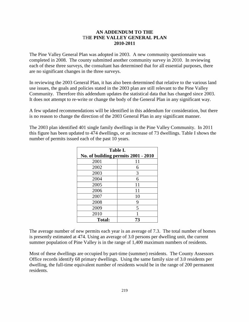
219
AN ADDENDUM TO THE THE PINE VALLEY GENERAL PLAN
2010-2011
The Pine Valley General Plan was adopted in 2003. A new community questionnaire was completed in 2008. The county submitted another community survey in 2010. In reviewing each of these three surveys, the consultant has determined that for all essential purposes, there are no significant changes in the three surveys. In reviewing the 2003 General Plan, it has also been determined that relative to the various land use issues, the goals and policies stated in the 2003 plan are still relevant to the Pine Valley Community. Therefore this addendum updates the statistical data that has changed since 2003. It does not attempt to re-write or change the body of the General Plan in any significant way. A few updated recommendations will be identified in this addendum for consideration, but there is no reason to change the direction of the 2003 General Plan in any significant manner. The 2003 plan identified 401 single family dwellings in the Pine Valley Community. In 2011 this figure has been updated to 474 dwellings, or an increase of 73 dwellings. Table I shows the number of permits issued each of the past 10 years.
Table I. No. of building permits 2001 - 2010
2001 11 2002 6 2003 3 2004 6 2005 11 2006 11 2007 10 2008 9 2009 5 2010 1
Total: 73 The average number of new permits each year is an average of 7.3. The total number of homes is presently estimated at 474. Using an average of 3.0 persons per dwelling unit, the current summer population of Pine Valley is in the range of 1,400 maximum numbers of residents. Most of these dwellings are occupied by part-time (summer) residents. The County Assessors Office records identify 68 primary dwellings. Using the same family size of 3.0 residents per dwelling, the full-time equivalent number of residents would be in the range of 200 permanent residents.
220
According to the 2003 plan, there are still vacant, un-subdivided parcels of private land that could be developed. The 2003 plan does estimate a build-out total for the valley. Using the same percentage of full-time residents as there are now, it would be possible to estimate the number of full-time residents that would be full-time in Pine Valley at the time of build out. The number of full-time as opposed to part-time residents could be expected to increase as a percentage total residents. Not knowing how many lots could be added from vacant parcels of property, there is no effort at this time to project the build out population separate from the projections of the 2003 plan. Land Use: Agriculture / Open Space: The 2003 policy of preserving the open space pasture land in the valley is still a valid policy. Efforts have been made to place much of this land in a conservation easement which would keep it as open space long into the future. Efforts should continue to effectuate this policy for all of the pasture land in the middle of the valley. High water table precludes subdivision of this land except for the fact that drain lines could be installed to increase the subdivide amount of land. The 2003 General Plan recommends that no development take place in the meadows beyond a depth of one block north of the main east-west road through the community. The General Plan still supports this one block deep policy. There may be other means of protecting this meadow land in addition to conservation easements on the land. If there are, these other means should be pursued. The conservation route is one method that would allow this land to be protected as permanent open space and still provide compensation to the property owners for not developing the land into subdivisions. Residential Development: The General Plan does not recommend any significant changes to the Residential section of the current Plan. Without a sewer system in Pine Valley, no multiple family dwellings can be accommodated. There is still room for additional residential development of the same character as currently exists. Vision Dixie Plan: 1. Plan regionally; implement locally - The General Plan for Pine Valley is a local plan for
the residents of this community. It is also recommended to be adopted as a part of the Washington County General Plan.
2. Maintain air and water quality and conserve water - Air and water quality is very
important to the home owners in Pine Valley. Air quality in Pine Valley is probably as good, or better, than any other area of the county. One of the main attractions to this area is the clean air and good quality of water. Water conservation is also important to the residents. Much of the landscaping is of a natural variety. The meadow areas are sub-
221
watered by the Santa Clara River as it passes through the valley. The meadow area is one of the main reasons that people are attracted to this area.
3. Guard our signature landscapes - Pine Valley as a community has some of the most
signature landscapes anywhere in the county. The views in all directions are beautiful and should be protected. The open space in the valley that is meadow land should and is being protected. The policies of the community indicate that he land surrounding the valley, National Forest Land, should not be disposed of or any type of development, but should be protected as open space. Much of the and to the south and east of the valley is currently in a wilderness classification.
4. Provide connected natural recreation areas and open spaces - This is covered by the
previous item in protection of the view shed surrounding the valley. Trails, camp grounds and open space land surrounds the valley and should be protected and maintained.
5. Build a balanced transportation system - there is no public transportation system in Pine
Valley, and a public system is not likely to come here anytime soon. The policies of the community call for improvement of existing access routes which is probably the best policy for the community to support at this time. Public transportation may come, but not during the period of the 2011 General Plan for Pine Valley.
6. Get centered by focusing on growth in walk-able mixed use centers – The residents of
Pine Valley are opposed to the creation of a mixed use commercial center in the valley. There is a commercial center of sorts in the area of the fire station, post office, restaurant, and motel facility. A small grocery store is currently zoned and could reopen under current ordinance. This center is not centered for walk-ability but with the residential development already existing from the Ranchos area to the campground on the east, is too far to expect people to walk. There is no where in the valley where such a centrally located center could be identified.
7. Direct growth inward - This policy is being followed in Pine Valley. The community is
an island of private land surrounded by public land. All development in the valley falls within this private area and does not suggest the release of any public land surrounding the valley for development.
8. Provide a wide range of housing types - This policy works well in the urbanized portions
of the county where sewer service is available. In Pine Valley, with a high water table, the current zoning reflects the maximum density that can be accommodated in the valley. Multi-family residential dwellings could not be supported in the valley at this time.
9. Reserve areas for Industry - This is another policy that could be supported in the
incorporated community areas of the county. Pine Valley is a summer home area. There is no significant permanent population to support industrial development, even if there were areas where it could be accommodated. Under the current pattern of development, there are no areas where industry could be supported in any fashion.
222
10. Public land conversion - There is no current public land in Pine Valley that is classified for disposal. There is none requested by the 2011 General Plan. Commercial Development: The residents of the valley, through three surveys over the past eight years, are all in agreement that there is no desire for additional commercial development in the valley. The General Plan should note that there was a small commercial general store type business in Pine Valley a few years ago. The building has not been used commercially for several years but is still zoned as a commercial site. Therefore, it could once again be revived commercially, or, the zone could be changed by the current owner to a residential zone. Public Facilities: Most of the sections of the 2003 General Plan relative to the various public services would appear to be viable in the year 2011. The goals and policies would appear to be adequate to continue well into the future. Circulation and Transportation: The goals and policies of the 2003 Plan are still viable in 2011. The one issue in Pine Valley that does not quite go away is the problem of ATV's. A number of the communities in the county have similar problems, but probably none as much as appears in Pine Valley. The General Plan has recommended in other communities, that the county would allow each of the unincorporated areas to develop their own ATV plan and that each community could post those regulations at the entrance to their community in the event that they are not satisfied with the current county policy. The 2011 General Plan for Pine Valley would recommend that this policy be tried in each community were there is concern with the current policy. The General Plan would recommend that each of the communities that would like to do so develop their own management plan and that the community be signed accordingly. Summary and Conclusions: The Washington County General Plan is in support of the 2003 General Plan for Pine Valley and recommends that it be included, as it is, in the 2011 General Plan. It is further recommended that this Addendum be added to the 2003 in order to update some statistical data to the current time. The citizen survey for 2003 is included in the 2003 Plan. This addendum proposes to add the two recent surveys as a part of the 2011 Addendum to the Plan, and the combination of these two documents be adopted by the County Commission as the 2011 General Plan for the Community of Pine Valley. Each of the individual Plans prepared for the unincorporated areas of the county include a summary of the policies of the Vision Dixie study as a part of each Plan. Following is a
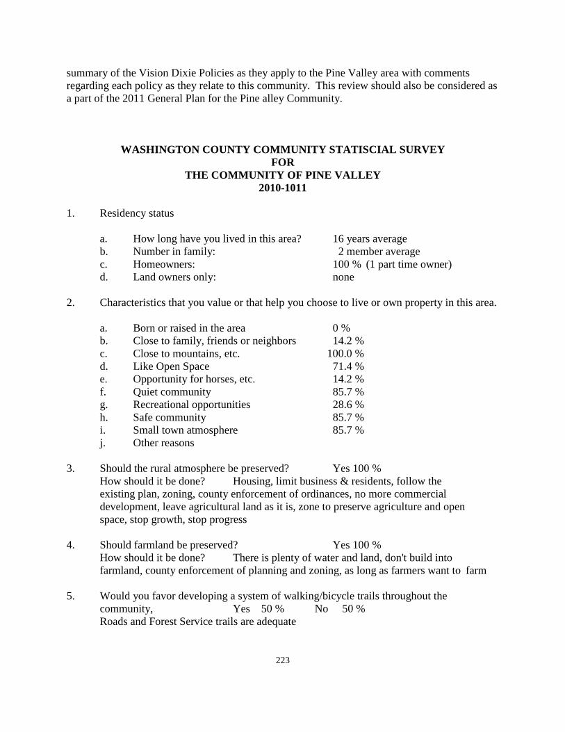
223
summary of the Vision Dixie Policies as they apply to the Pine Valley area with comments regarding each policy as they relate to this community. This review should also be considered as a part of the 2011 General Plan for the Pine alley Community.
WASHINGTON COUNTY COMMUNITY STATISCIAL SURVEY FOR
THE COMMUNITY OF PINE VALLEY 2010-1011
1. Residency status a. How long have you lived in this area? 16 years average b. Number in family: 2 member average c. Homeowners: 100 % (1 part time owner) d. Land owners only: none 2. Characteristics that you value or that help you choose to live or own property in this area. a. Born or raised in the area 0 % b. Close to family, friends or neighbors 14.2 % c. Close to mountains, etc. 100.0 % d. Like Open Space 71.4 % e. Opportunity for horses, etc. 14.2 % f. Quiet community 85.7 % g. Recreational opportunities 28.6 % h. Safe community 85.7 % i. Small town atmosphere 85.7 % j. Other reasons 3. Should the rural atmosphere be preserved? Yes 100 % How should it be done? Housing, limit business & residents, follow the existing plan, zoning, county enforcement of ordinances, no more commercial development, leave agricultural land as it is, zone to preserve agriculture and open space, stop growth, stop progress 4. Should farmland be preserved? Yes 100 % How should it be done? There is plenty of water and land, don't build into farmland, county enforcement of planning and zoning, as long as farmers want to farm 5. Would you favor developing a system of walking/bicycle trails throughout the community, Yes 50 % No 50 % Roads and Forest Service trails are adequate
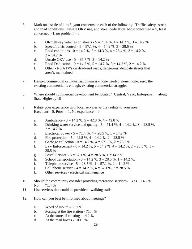
224
6. Mark on a scale of 1 to 5, your concerns on each of the following: Traffic safety, street and road conditions, , unsafe ORV use, and street dedication Most concerned = 5, least concerned =1, no problem = 0
a. Of-highway vehicles on streets - 5 = 71.4 %, 4 = 14.2 %, 3 = 14.2 %, b. Speed/traffic control - 5 = 57.1 %, 4 = 14.2 %, 3 = 28.6 % c. Road conditions - 0 = 14.2 %, 5 = 14.3 %, 4 = 26.4 %, 3 = 14.2 %, 2 = 14.2 % d. Unsafe ORV use - 5 = 85.7 %, 3 = 14.2 % e. Road Dedication - 0 = 14.2 %, 5 = 14.2 %, 3 = 14.2 %, 2 = 14.2 % f. Other - No ATV's on dead-end roads, dangerous, dedicate streets that aren’t, maintained 7. Desired commercial or industrial business - none needed, none, none, zero, the existing commercial is enough, existing commercial struggles 8. Where should commercial development be located? Central, Veyo, Enterprise, along
State Highway 18 9. Relate your experience with local services as they relate to your area: Excellent = 5, Poor = 1, No experience = 0 a. Ambulance - 0 = 14.2 %, 5 = 42.8 %, 4 = 42.8 % b. Drinking water service and quality - 5 = 71.4 %, 4 = 14.2 %, 3 = 28.5 %, 2 = 14.2 % c. Electrical power - 5 = 71.4 %, 4 = 28.5 %, 1 = 14,2 % d. Fire protection - 5 = 42.8 %, 4 = 14.2 %, 2 = 28.5 % e. Garbage collection - 0 = 14.2 %, 4 = 57.1 %, 2 = 28.5 % f. Law Enforcement - 0 = 14.2 %, 5 = 14.2 %, 4 = 14.2 %, 2 = 28.5 %, 1 = 28.5 % g. Postal Service - 5 = 57.1 %, 4 = 28.5 %, 1 = 14.2 % h. School transportation - 0 = 14.2 %, 3 = 28.5 %, 1 = 14.2 %, i. Telephone service - 5 = 28.5 %, 4 = 57.1 %, 2 = 14.2 % j. Cell phone service - 4 = 14.2 %, 4 = 57.1 %, 2 = 28.5 % k. Other services - electrical maintenance 10. Should the community consider providing recreation services? Yes 14.2 % No 71.4 % 11. List services that could be provided - walking trails 12. How can you best be informed about meetings? a. Word of mouth - 85.7 %. b. Posting at the fire station - 71.4 % c. At the store, if existing - 14.2 % d. At the mail boxes - 100.0 %
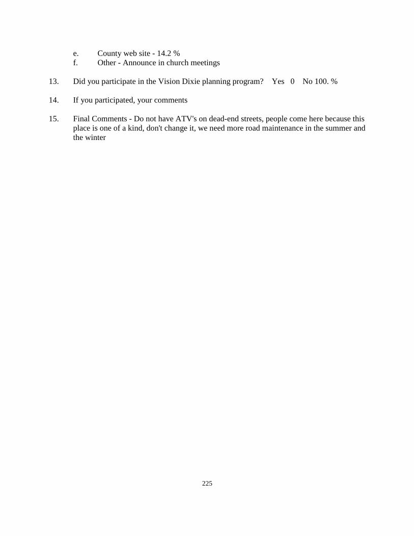
225
e. County web site - 14.2 % f. Other - Announce in church meetings 13. Did you participate in the Vision Dixie planning program? Yes 0 No 100. % 14. If you participated, your comments 15. Final Comments - Do not have ATV's on dead-end streets, people come here because this
place is one of a kind, don't change it, we need more road maintenance in the summer and the winter
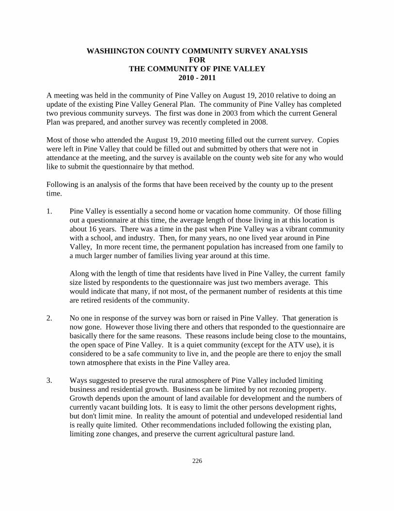
226
WASHIINGTON COUNTY COMMUNITY SURVEY ANALYSIS FOR
THE COMMUNITY OF PINE VALLEY 2010 - 2011
A meeting was held in the community of Pine Valley on August 19, 2010 relative to doing an update of the existing Pine Valley General Plan. The community of Pine Valley has completed two previous community surveys. The first was done in 2003 from which the current General Plan was prepared, and another survey was recently completed in 2008. Most of those who attended the August 19, 2010 meeting filled out the current survey. Copies were left in Pine Valley that could be filled out and submitted by others that were not in attendance at the meeting, and the survey is available on the county web site for any who would like to submit the questionnaire by that method. Following is an analysis of the forms that have been received by the county up to the present time. 1. Pine Valley is essentially a second home or vacation home community. Of those filling
out a questionnaire at this time, the average length of those living in at this location is about 16 years. There was a time in the past when Pine Valley was a vibrant community with a school, and industry. Then, for many years, no one lived year around in Pine Valley, In more recent time, the permanent population has increased from one family to a much larger number of families living year around at this time.
Along with the length of time that residents have lived in Pine Valley, the current family size listed by respondents to the questionnaire was just two members average. This would indicate that many, if not most, of the permanent number of residents at this time are retired residents of the community.
2. No one in response of the survey was born or raised in Pine Valley. That generation is
now gone. However those living there and others that responded to the questionnaire are basically there for the same reasons. These reasons include being close to the mountains, the open space of Pine Valley. It is a quiet community (except for the ATV use), it is considered to be a safe community to live in, and the people are there to enjoy the small town atmosphere that exists in the Pine Valley area.
3. Ways suggested to preserve the rural atmosphere of Pine Valley included limiting
business and residential growth. Business can be limited by not rezoning property. Growth depends upon the amount of land available for development and the numbers of currently vacant building lots. It is easy to limit the other persons development rights, but don't limit mine. In reality the amount of potential and undeveloped residential land is really quite limited. Other recommendations included following the existing plan, limiting zone changes, and preserve the current agricultural pasture land.
227
4. All respondents recommend protecting the agricultural land. Protecting the agricultural land is easy as long as the owner wants to continue the use of the land. However, should they decide to sell the land for development, protection becomes much more difficult. The plan will consider alternatives to the typical process of protecting land and will suggest possible alternatives.
5. The respondents were evenly split on whether or not to provide walking or bicycle trails
in the community. Some suggested that roadways and the forest service provide adequate facilities with adding more. It is true that all existing roadways are automatically walking areas and bicycle lanes. Whether to develop any others that may be limited to walking or bicycling is a split opinion of those providing input on the subject.
6, On a scale of 0 - 5, list your concerns relative to off-highway vehicles, speed controls,
road conditions, unsafe ORV use, road dedications, etc.
Concerns of off-highway vehicles on local streets is a major concern to most residents, along with speed control, and unsafe ATV use are the major uses identified as being a problem in Pine Valley. This has been an ongoing problem in the valley for many years. If all residents, full-time and part-time, are questioned, it would be interesting to see what percentage see ATV's as big a problem as those filling in the questionnaire feel that it is. Inn either event it is a community problem here as well as in other areas of the county and needs to be addressed once again as a part of the General Plan.
No other concerns relative to the use of the roadways in Pine Valley generated any significant concern aside from those concerns listed above.
7. According to the questionnaire, no additional commercial business is needed in addition
to those already there. Some years ago, there was a small grocery store in the valley for several summers. It is no longer in business, but could be proposed again at some future time.
8. As to there commercial land should be located the suggestions included - along State
Highway 18, Central, Veyo, and Enterprise. Definitely do not locate more commercial developments in Pine Valley.
9. Experience with Public services including Ambulance, drinking water, electricity, fire protection, garbage collection, law enforcement, postal service, school transportation, telephone service, and cell phone services. Several of the public services receive generally high marks from the respondents. Those things receiving the highest marks include most of the services that are provided within the community including such things as drinking water, electrical power, fire protection, postal service, and telephone service. Getting passing marks are services such as ambulance, cell phone service, and marginally, garbage collection.
228
Receiving less than satisfactory marks include services such as police protection and school transportation. In the county, a community may contract for as much protection as they desire to pay for, including 24 hour, 365 day protection.
10. Should the community provide for recreation activities? The preponderance of responses said No, that recreation facilities was an area for the community to get involved with. 11. Walking trails were recommended by those suggesting that recreation activities could be
provided. 12. Getting informed about meetings is always a problem in the unincorporated areas of the
county. Posting at the mail boxes was rated the most successful method of being informed, with posting at the fire station, next door to the mail boxes, as the next most useful method. The county web site is already in use, but residents are obviously not used to using this method.
13. Participation in the Vision Dixie planning program was listed 100 % as No. That
participation level is typical with most of the other unincorporated communities in the county. Yet, there were many such meetings held out in the unincorporated areas, at which there was always good attendance.
14. No comments from the Vision Dixie plan were mentioned. 15. Final comments included a comment to not allow ATV's on dead-end streets. More road
maintenance was requested in the summer as well as the winter. It was mentioned that Pine Valley attracts people because it is "one of a kind" and that it should not be changed and should be protected. There are things that can be done to accomplish this that will be mentioned in the General Plan.
229
PINE VALLEY COMMUNITY GENERAL PLAN
2003 INTRODUCTION The General Plan for the Pine Valley Community is a part of the General Plan of Washington County. Planning in Washington County began about 1970 and has continued since that time. The most recent update of the plan was in November 1995. However, a Plan for the Pine Valley Community was prepared in 1992 but did not consider the Pine Valley area in any detail. In the year 2002, the County Commission appointed a planning committee to work with the County in the updating of the General Plan for Pine Valley. This committee has work diligently for the past year to gather information relating to the valley, review and strive to understand the information gathered and to prepare an updated plan for the Pine Valley Community. Included in this effort was a community survey sent to all property owners in the valley to gain input as to the things that are important to those that live here whether year around or during the summer months. This plan then, becomes the first comprehensive look at the Pine Valley Community area. BASIS FOR PLANNING The authority for a General Plan comes from enabling legislation passed by the State of Utah and found in the Utah Code, Article 17, which outlines the methods to be followed, and charges the County Planning Commission with the development of a General Plan. Many other public agencies also are involved in planning for the areas that they are responsible for, such as the Bureau of Land Management, the National Forest, and the National Park. The Forest Service is presently involved in an update of the Forest Management plan for the Dixie National Forest that will impact land surrounding the Pine Valley Community. PURPOSE OF THE PLAN The purpose of the plan is to serve as a guide for orderly development. It sets the pattern for growth and change. It expresses the goals as to what the area should look like in the future, and it establishes the policies or guidelines for achieving these goals. THE GENERAL PLAN AND ACTION Effectuating the Plan is the responsibility of public and private groups. The Plan alone does not cause things to happen, nor does it give precise recommendations for development of various projects. The Plan provides the road map to follow. Vehicles of implementation, such as the Zoning Ordinance and the Subdivision Ordinance, are needed to carry out the provisions of the General Plan.
230
UNDERSTANDING THE PLAN The General Plan identifies various land use categories and considers the use of each of these classifications. Many of these types of land use are considered in terms of Goals and Policies that are adopted as a part of the Plan. Goals and policies are described as follows: A GOAL represents an objective relative to some aspect of development that the County has determined to achieve. A POLICY is an action that will allow, or help the County to achieve the desired goal. ELEMENTS OF THE PLAN The Pine Valley Community is a beautiful area with many unique characteristics. There are many qualities about the area that set it apart from other areas of the County. Therefore, as the area continues to grow and develop, it is necessary that the things that make Pine Valley what it is, are preserved. The amount of land is limited because the valley is surrounded by public land under the jurisdiction of the National Forest system. There is a limit to the amount of water that can be developed in the area as well as a limit to the number or solid waste (septic tank) disposal units that can be constructed without the need for a central collection and treatment system. It is the intent of the Plan to guide development in a manner that will maintain and protect the values that have caused people to come to this area. The Goals and Policies of the County to accomplish this purpose are identified in the various elements of the plan. BACKGROUND AND HISTORY Pine Valley is located near the geographical center of Washington County. The valley is surrounded by the Pine Valley Mountains. Vehicular access is limited to a paved Forest Service road running eastward from the town of Central. Central is served by State Highway 18 which connects St. George on the south and Enterprise on the north. Andrew Karl Larson in his book I Was Called to Dixie, describes Pine Valley in the following Manner. “Pine Valley is near the headwaters of the Santa Clara, in a sequestered spot that delights the eye of the beholder when it comes suddenly into view as he tops the hill on the northwest. So must it have delighted the sensibilities of Isaac Riddle when the valley came into his vision as he came over the eastern rim in 1855 looking for a strayed cow belonging to the members of the Indian Mission at Fort Harmony. What he saw was tall lush grass that rubbed his horse’s belly and wet his stirruped feet as he rode through an area yet untouched by man. The tall timber of aspen, spruce, and pine grew thick on the slopes of the rugged hills and in the canyons that opened into the valley.”
231
Timber attracted the first settlers of the valley and with the construction of a saw mill in the valley in the fall of 1855, much needed timber and shingles were provided to surrounding settlements including the St. George valley, southern Nevada settlements as far south as the Muddy settlement near Overton and to Pioche on the north, as well as to Silver Reef on the east side of the mountain. In fact, timber for the St. George LDS Tabernacle, and the Salt Lake Tabernacle Organ came from Pine Valley. As the timber industry gradually died out, farming and livestock raising increased. In 1868 the frame chapel, designed by Ebenezer Bryce, an Australian ship builder, was built of native timber. There are still a number of pioneer homes standing in Pine Valley as evidence of the work of early pioneer stock settling in the valley. In time the number of residents in the valley declined from a high of about 300 until finally there were no full-time residents living there. Over the years, Pine Valley became more known as a summer home area for residents of southern Washington County and southern Nevada. Not until the 1970's did people once again began living year around in Pine Valley. There are currently 30 - 35 families claiming Pine Valley as their permanent home. That number increases many fold during the summer months when seasonal residents return for the summer. QUALITY OF LIFE There is a quality of life in Pine Valley that is available nowhere else in this area. The town has a historic flavor to it because of its history and background. This element itself creates a certain feeling toward the valley because of its pioneer heritage. Another factor that impacts the quality of life is the surrounding National Forest. The valley is a small island surrounded by public land, thus limiting the amount of development that can take place. The Forest Service is encouraged not to trade private land found elsewhere in the National Forest for land adjacent to Pine Valley. The size and scale of the community are very important to the residents of Pine Valley. The fact that the valley is predominantly made up of residential dwellings and open space, without the impact of significant commercial or any industrial development, adds to its unique character. As identified throughout this plan, the residential and open space character of the valley should be protected and preserved while other conflicting uses should continue, for the most part, to be minimized. Any industrial development should not be allowed. Changes to the character of the valley should come slowly, and then only after careful thought and consideration as to their impact on the quality of life that people here have come to expect. Besides the temperature change in Pine Valley compared with the temperatures elsewhere in southern Utah and southern Nevada, it is the quality of life that attracts people to the Pine Valley area. This plan attempts to identify in more detail some of the qualities that make Pine Valley what it is, and recommendations are made for maintaining that quality while still allowing the valley to continue to grow and develop.
232
TOPOGRAPHY, GEOLOGY, AND CLIMATE Pine Valley is set in the midst of the hills of the Pine Valley Mountains. Located at an elevation just over 6,500 feet above sea level, the valley is several thousand feet higher than the southern part of the County. It is small wonder that the early settlers quickly learned about going to Pine Valley during the hot summer months. Temperatures in the valley vary in the summer with warm days and cool evenings. The valley remains cool until after sunrise in the mornings. High daytime temperatures may be in the 80's compared to well over 100 degrees in the lower valleys. Winter temperatures are much cooler with daytime temperatures often remaining below freezing and dipping well below zero at night. The community is somewhat flat with a general slope from the easterly end of the valley to the west. Mountain slopes rise rapidly from the valley floor to the tops of the mountains at over 10,000 feet in elevation. The valley is generally located within tertiary sedimentary and igneous rock formations which in turn are underlain by the claron, grapevine wash, iron springs, dakota, carmel, and temple cap formations before reaching the navajo sandstone. ENVIRONMENTAL CONDITIONS The major environmental concern in Pine Valley is the effect that groundwater has on the future development of the valley and the impact that it may have on other areas outside of the valley itself. From the groundwater protection study developed by Hansen, Allen, and Luce, published in July 1998, two potential areas of concern are identified as follows: 1. Groundwater flow patterns within the valley are generally controlled by alluvial flow
systems with ground water gradients of 6.7% to the west toward the town of Central. With a developed zone some 4,500 feet wide, an average saturated thickness on the order of 200 feet, and a permeability of between 10 and 25 feet/day. The total ground water moving westward would be between 5,050 and 121,653 acre feet per year. It is estimated that it would take approximately 18.5 years for a contaminant originating in Pine Valley to travel the five miles to Central.
2. The second community potentially impacted by Pine Valley contamination may be those
utilizing ground water wells located within the Millcreek drainage north of Washington. A review of geologic mapping shows strong north-south trending fracture systems which have been documented to traverse at least 2/3 of the distance between Pine Valley and the City of Washington. A contamination source therefore within Pine Valley that entered an open fault system may find it way to the Millcreek well field. Should such a flow path exist, it is estimated that it would take some 75 to 80 years for the contaminant to show up in the Millcreek drainage.
233
The same groundwater protection study made a recommendation for septic tank density to protect downstream water from becoming contaminated. The actual figures from the study indicate a density of two acres per septic tank in the Pine Valley area. Such a density, applied to the land in the basin, would allow for an additional 520 dwelling units north of the river and 1,610 dwelling units south of the river. These figures likely represent more dwelling units than the amount of vacant, privately owned land will support at a full build-out level. This is particularly true if no development takes place in the meadow area of the valley where the water table is probably too high to permit installation of septic tanks. LAND USE ANALYSIS During the fall of 2002, a land use survey of the valley was completed by members of the Planning and Historical committee. The valley was divided up into sections and the survey was recorded by section. (See Figure 1) The number of single family homes at the present time in the valley is 401. Additionally, there were 300 vacant building lots identified which could provide sites for 300 more homes to be built. Most of the existing homes are second dwellings or summer homes. However, there are presently about 35 of these homes occupied on a full-time basis by year-around residents. Using the State average of persons per dwelling unit of 3.7, there could be as many as 1,483 residents of Pine Valley in the area on any given day or weekend during the summer months when most of the dwellings are occupied. An additional 1,110 residents could be added if all vacant building lots were built on. In addition to the residential lots, there are 18 parcels of agricultural land that also contain residential dwellings. They are classified in the land use survey as residential agriculture. This would increase the population potential by another 66 residents, making the present “build-out” population of Pine Valley somewhere near 2,650 to 2700 residents. While most of these would be summer time residents, the number of year around residents continues to increase. Besides the parcels of land discussed above, there were identified some 19 vacant parcels of varying sizes throughout the valley. This number indicates that there is still additional land that could be developed with building lots in the future, with a still greater increase in the number of potential residents. While not specifically a part of Pine Valley insofar as this planning study is concerned, the National Forest campground east of Pine Valley provides campsites used by residents of other areas. This adds many more people to the population of the region at any given time. The campers are not considered to be residents of the valley. However, they all travel through the valley to and from the campground which adds traffic on the streets. Others come to the valley to stay at the Pine Valley lodge, or to eat at the fine restaurant in Pine Valley. Some others come to Pine Valley simply to sightsee, or to get away from the heat of the lower valley for a period of time. Other uses identified in the land use survey include commercial uses which include the lodge, restaurant, and a real estate office. There is also a church building in Pine Valley. Dixie State
234
College maintains a building in Pine Valley for educational purposes related to the College. It is not available for use by the general public. The National Forest also maintains buildings inside the town site of Pine Valley. These include a visitor center, lodging facilities for employees, and maintenance facilities. There are a new and an old fire station in the valley as well as a Post Office facility. The fire station also includes a meeting room that is used for town meetings of the Special Service District Board and the Planning and Historic Advisory Committee. The largest single use of land in Pine Valley is for agricultural use. The beautiful meadows that lie in the center part of the valley encompass some 550 acres. Much of this land is sub-irrigated by the Santa Clara River flowing through the valley. This same river, because of the high water table that it creates through much of the meadow land, causes much of the land to be unsuited for installation of septic tanks which would be required for residential development. For this reason, unless a sewage disposal system was installed in the valley, which most residents hope to avoid, the land will, for the most part, probably remain classified as agricultural land. Altogether in the Pine Valley community town site there are approximately 1,300 acres of land. This acreage includes the cemetery that was originally part of the National Forest, but was deeded to the Pine Valley Water Company some years ago for upkeep and maintenance. The cemetery lies just outside of and adjacent to the original town site. AGRICULTURE / OPEN SPACE Agricultural and open space areas of the valley may include the National Forest land surrounding the community, some of the steep hillside slopes in parts of the valley, and the meadows along the Santa Clara River running through the center of the valley. Following are goals and policies relative to the agriculture / open space classification and use of land in the Pine Valley community:
GOAL: Identify agricultural / open space areas within the valley and provide protection
from development in the areas identified. Areas that because of steep slopes, high water table, or other natural considerations should be maintained as agricultural or open space areas in order to protect the health, safety, and welfare of the present and future residents of the valley.
POLICIES:
• Maintain an agricultural / open space designation along the Santa Clara River and all associated land having a high water table not conducive to septic tank installation.
• Some of the meadow areas may be in the 100-year flood plain. Do not issue
building permits, or approve subdivisions in these areas.
235
• There are some streams and washes coming from the adjacent hills toward the Santa Clara River. Maintain these streams and washes and preclude them from being developed, or filled in by other adjacent development.
• Encourage the National Forest not to exchange any forest land in the valley for
private land located elsewhere in the County. Allow the public lands to provide a buffer between the valley and other private lands outside the valley.
• Protect steep hillside land from being scarred by grading for home or subdivision
development.
• Continue to encourage uses in agricultural and open space areas that will allow these areas to remain open. Livestock grazing in the valley should be continued and encouraged on low lying lands with a high water table.
• Establish zoning classifications that will preserve the Agricultural / open space
lands identified in the valley as well as protecting the open space forest lands surrounding the valley.
• Encourage “green belt” classification of agricultural land.
• Encourage the establishment of agricultural protection areas according to State
and County ordinances to protect the agricultural use. • Educate new residents as to the agricultural character of the valley and solicit
their support for agricultural use of land to avoid citizen complaints against livestock grazing operations.
• Work to maintain the quality of water in the Santa Clara River as it passes
through the Pine Valley community.
RESIDENTIAL DEVELOPMENT Residential development is the primary type of development taking place in the Pine Valley community. There are three distinct residential areas in the valley. These include (1) the west area located nearby, (2) the central part of the valley which is dominated by the original town site development of lots, blocks, and streets, and (3) the subdivision and commercial development lying between the original town site and the forest boundary on the east
GOAL: To provide for residential housing in attractive, functional neighborhoods to meet
the needs of potential residents. POLICIES:
236
• Residential development should be encouraged to continue as the predominant type of development in the valley.
• Continue to use the same standards for manufactured homes as for other types of
residential construction.
• The Zoning Ordinance should be used to determine the housing densities in different areas. Identify such densities in areas where they are not already designated.
• Maintain the overall density recommendations of the Ground Water Protection
Study.
• Consider developing a plan for density transfer from areas where development is not feasible to areas where a greater density could be approved.
• Encourage home owners to use “earth tones” on exterior and roof treatments
when constructing new homes in order to create a community that harmonizes without calling undue attention to particular dwellings because of bright color tones.
• Encourage residents to plant trees within lots and along streets. This would help
beautify the town, and by placing the town under a canopy of trees, it would help provide shade and cooler temperatures during the summer months.
• There are many “small” parcels of residential property in the original town plat. While these small lots are legal lots of record, lot owners should be encouraged to combine small lots into larger parcels that comply with the current zoning classifications.
• Encourage new residents to take into account the relationship of their home to
those around them in considering the height and size of a new dwelling, the direction of desirable views, etc., in order to help maintain a sense of scale in the valley, thereby not simply creating a valley filled with “large boxes” which block the view shed of others.
COMMERCIAL DEVELOPMENT Commercial development in the Pine Valley Community should be kept to the minimum needed to serve the convenience needs of the residents. People are attracted to Pine Valley not only because of the summer climate, but also the peace and quiet that prevail in the valley. No development which could change that characteristic of the valley should take place. Most residents are not in favor of additional commercial development as evidenced by the responses to the citizen survey recently sent out and returned by residents of the valley. Respect the wishes of the majority of the residents. The number of requests by single individuals for
237
specific commercial businesses does not warrant significant expansion of the commercial area beyond the present boundaries.
GOAL: Allow only sufficient development to provide for the convenience commercial needs of valley residents.
POLICIES:
• Limit commercial development to the areas where limited commercial development already exists in the valley.
• Any request for additional commercial business must provide for water and waste
disposal in the same manner as for residential development.
• Encourage existing commercial business to maintain a high quality of appearance and service.
• Do not permit any commercial or noncommercial activity in the valley that would
generate light, sound, or increased traffic not consistent with normal residential development
PUBLIC FACILITIES Public facilities account for a great number of things that are of importance to the residents of the Pine Valley community inasmuch as individual home owners and business owners are dependent upon such things as water, power, waste disposal, access and circulation, and other similar infrastructure that goes toward making up a viable and liveable community. The following are some of the services that are available in one form or another that go toward making Pine Valley a delightful place to live.
Cemetery The Pine Valley cemetery is located at the intersection of the Pine Valley road and
the roadway running eastward from the Pine Valley road along the north side of the valley. The cemetery is owned and operated by the Pine Valley Irrigation Company. The size of the property is ten acres, about two acres of which have been developed and platted.
There is no landscaping in the cemetery, but it is covered with natural vegetation.
There is no water available and maintenance is done by way of volunteer labor during periodic cleanup days. The road to the cemetery and parking at the cemetery have recently been graveled and improved. It is estimated that the cemetery should serve the community for at least fifty years. There is a charge for burial plots which could be amended from time to time by the water company.
238
GOAL: Provide an area where those desiring to do so can acquire burial plots and be buried in the Pine Valley cemetery at a minimal cost.
POLICIES
• Continue to maintain the cemetery as is presently done by the Pine Valley Irrigation Company.
• Encourage citizens to “turn out” to help on clean up days to keep the cemetery
looking neat and attractive.
• Do not change the character of the cemetery through the removal of natural vegetation, landscaping, etc.
Fire Protection The Pine Valley fire department consists of one paid officer and one paid secretary along with a volunteer force of 14. The department has a new (1998) fire station, 2 pumpers, 1 reserve pumper, and two brush trucks. The present fire rating is a 6. This was last evaluated in 1998. The fire department works under the supervision of the Special Service District.
GOAL: Continue to improve the ability of the fire department to serve the community of
Pine Valley, and continually work to lower the fire rating from its present level. POLICIES:
• Continue to train fire fighters in all aspects of fire fighting, including structural
and wild land fire fighting.
• Continue to acquire fire fighting equipment for the fire fighters.
• Encourage the Forest Service to continue to develop a “fire break” around the community on the adjacent forest service land.
• Continue to work with the irrigation company to install additional fire hydrants in
newly developed areas and to locate additional hydrants in already developed areas as necessary.
Law Enforcement
Washington County is responsible for law enforcement in the Pine Valley area. The County also has a contract with the Forest Service to provide law enforcement on National Forest land adjacent to the community, including the forest campground area.
239
GOAL: Continue to improve the level of law enforcement in Pine Valley.
POLICIES:
• Work with the County Sheriff and other County authorities encouraging them to increase the number of patrols in Pine Valley especially during the summer season and on holiday weekends.
• Work toward having a full-time or part-time officer in Pine Valley during summer
or peak times of the year, and encourage more coverage during the off-season.
Postal Service Postal service is provided by the United States Postal Service office out of Cedar City Utah. Deliveries are made six days per week, excluding Sunday’s and holidays. Mail is delivered to a building located on Main Street, next to the fire station. The facility provides a mail drop only, and no other services are available. There are 304 regular boxes that are available. The current level of service is excellent.
GOAL: To maintain the quality of service that is presently available to residents of the Pine Valley area, and to continue to improve facilities and service as time goes on.
POLICIES:
• Continue to make the Pine Valley Post Office one that the residents of the valley
and the Post Office officials can be proud of.
• Continue to provide a service to the residents of the valley by having bulletin board space announcing community activities and making the post office a gathering place for residents.
• Expand the facility as necessary to provide for the needs of the residents, and at
some future time, construct a permanent, enclosed building with additional services found at regular post office buildings.
Waste Disposal Presently the valley is served by a common garbage disposal site about one mile out of town on land provided by the Forest Service adjacent to the highway coming into Pine Valley. The site is maintained by the Washington County solid waste district. The district is made up of one representative from each of the incorporated cities in the County and one County representative. This facility provides a significant improvement over previous collection sites which provided for several small collection sites around the valley.
240
GOAL: Work with the solid waste district to continue to improve the quality of service at the collection site, especially during summer months, on weekends and holidays.
POLICIES:
• Continue to keep the area around the dumpsters cleaned up and presentable to
residents and visitors.
• Request from the solid waste district that collections be more often on weekends and holiday periods.
• Work to have larger dumpsters (roll-offs) made available at the site for weekend
and holiday use.
• Continue to increase the number of dumpsters beyond the present number as the community continues to grow and develop with more and more residents using the service.
Culinary Water Culinary water to Pine Valley is provided through springs and storage tanks located in various parts of the valley. There is a 200,000 gallon storage tank on the west side of town and a 250,000 gallon tank on the east side. The main spring produces a flow varying between 630 and 250 gallons per minute depending upon he season and the length of the drought that the area is currently in. Four Hundred acre feet of water is presently committed to the system and an additional 1,800 acre feet could be added as necessary. A new well is currently nearing completion and will be added to the system as soon as it is complete.
GOAL: Make certain that there is sufficient culinary water available at all times to serve
the needs of the community for culinary use and for fire protection. POLICIES:
• Monitor the system regularly to determine that there is adequate water in the system at all times to meet the needs of the valley.
• Comply with all State testing and monitoring requirements to make sure that the
system is state approved at all times.
• Add additional water to the system when necessary to provide for the needs of the residents.
241
• Continue to upgrade the distribution system throughout the valley to make sure that there is adequate water and water pressure available at all times.
• Make sure that there are adequate fire hydrants throughout the community to
provide for fire protection. Coordinate fire fighting needs with the fire department. Electricity Pine Valley is served by the Dixie Escalante Rural Electric Company. The
capacity of the line at the present time is 2.5 megawatts. A new line has been constructed from Pinto which will provide 13.7 megawatts of power. The equipment for a new substation has been ordered, and will be installed within a week of its arrival. It will be located near the solid waste facility and will allow the 13.7 megawatts to be utilized. The system would then be adequate to serve approximately one thousand dwellings.
GOAL: Develop sufficient electrical power in Pine Valley to provide for the present and
future needs of the residents, both permanent and part-time. POLICIES:
• Support the Forest Service in providing the necessary easements to allow the substation to be constructed.
• Encourage development of the new substation as soon as possible to continue to
make adequate power available.
• Monitor the electric needs of the valley and communicate the need for power regularly with the power company.
Communication Pine Valley is presently served by Quest communications for telephone service. According to telephone company representatives, there is sufficient capacity in the present system to provide telephone service to anyone in the valley at the present time and well into the future. Only if some type of large-scale development took place would the amount of lines available become a problem.
Presently fiber optic lines run only as near as the Veyo area. They may not be readily available in Pine Valley. Because of the seasonal character of the valley, major changes in the telephone system are not anticipated in the near future other than continuing to accommodate the request for telephone service by single family home owners on an as-needed basis.
Depending upon the company providing the service, and the location in the valley of the person using a cellular telephone, cellular phones provide some additional service to the area. Quality of service by cellular telephone is known to vary somewhat throughout the valley.
242
GOAL: Continue to have good telephone service provided to residents of Pine Valley.
POLICIES • Support the telephone company as necessary in continuing to provide adequate
telephone service to the valley.
• Encourage the telephone company to continue to upgrade the system with improved capabilities as they are able to do so.
• Do not support the installation of cellular towers anywhere in the valley where
they could be seen by residents from their various home locations. Circulation & Transportation Circulation and transportation are very important to the residents of the Pine Valley community. Only the main road from Central to Pine Valley is a paved road. This road extends through the community to the Pine Valley Forest Camp Ground, and westerly to the western end of Main Street. All other streets, except those in some of the more recent subdivision developments, are gravel roads. A secondary access into Pine Valley is on Forest Service land running north from the Pine Valley / Central road. This roadway runs through Grass Valley and connects with the Pinto and New Castle areas. This road is generally unimproved, and it would be up to the Forest Service to make any needed improvements.
GOAL: Work with Washington County and the Forest Service to continue to improve and upgrade the roads in the Pine Valley community.
POLICIES:
• Prepare a map of roads in Pine Valley and identify the condition and needs associated with each roadway.
• Discuss with the County the present level of maintenance that is provided in each
of these road areas.
• Encourage the County to work with the Forest Service for continued improvement of the road between Pine Valley and Central.
• Encourage land owners in any given subdivision who desire to have their roads
paved to work together, or with the County, to create improved districts for those areas desiring improvement.

243
• Work to encourage the Forest Service to dedicate their portion of the roadway
serving the north side of the valley.
• Work with the County to develop a plan for snow removal to be carried out on valley roadways during winter months.
Historic Preservation There are a number of historic homes and other locations in Pine Valley. Several homes were built by early settlers and are still used today. In addition, the site is still known of several historical sites related to the lumber industry that should be identified and preserved.
GOAL: Preserve and identify historic homes and other historic sites in Pine Valley.
POLICIES:
• Catalog the location of all historic homes and other historic sites in the valley.
• Create an identifying marker or historic sign that could be used to identify each of the previously cataloged sites.
• Map the location of each identified site and make this map available to residents
and visitors to the valley.
• Prepare a short written history of each of the historic sites identified. Include the history as a part of a visitor’s guide or historic map of the valley.
Parks & Recreation Pine Valley is surrounded by the National Forest. In addition, there is a forest camp ground adjacent to the community. Most of the people who come to Pine Valley come for rest and relaxation. The recent community survey filled out by full-time and part-time residents indicated that there is no current demand for structured recreation facilities in Pine Valley.
There is sufficient land adjacent to the fire station, approximately nine acres, that could be developed at some future time for park, recreation, and picnic facilities should the demand for such kind of activity increase in the future. Likely such improvements would be made by the volunteer efforts of residents. At this time, no structured recreation facilities are planned for Pine Valley. This reflects the desire of most of those returning survey forms. The adjacent Forest Service development provides for picnics, hiking, fishing, and other relaxing activities. Paths & Trails
244
There are presently a significant number of walking and hiking trails in the valley with trail-heads on Forest Service land. Some of these trails allow motorized activity, but some do not. Maps of trail systems are available at the Forest Service visitor center. The citizen survey recently completed indicated that there is not a demand or a need for walking, or trails of other kinds, to be developed in the community at this time.
Pine Valley is in an area where various trails are planned and are in the process of being proposed on a broad scope as a part of a countywide or multi-county trail system. Some of these trails may connect closely to the Pine Valley area. The Pine Valley community is opposed to any inter-county trails passing through the community. In approving any such trail system, provision must be made to go around the town rather than through any portion of it. The construction of a bridge across the gulch west of town has been discussed. This would provide the necessary connection between the Grass Valley Forest Service road and the old Pine Valley road on the south side of the gulch and west of town. A better solution might be to locate any inter-county trail further to west of Pine Valley entirely.
Additional efforts toward local trail development could be taken up again at some future time when there is an indication that such facilities would be desirable to residents of Pine Valley.
Special Service District As with most of the unincorporated parts of the County, and authorized under authority of the Utah Code, a Special Service District has been created in the Pine Valley Community. Special Service Districts are created for the purpose of providing for the special needs of a given area that may not be needed in exactly the same manner as other areas of the County. The Pine Valley Special Service District was created by resolution of the County Commission on December 27, 1978
This Special Service District was formed primarily to take care of the needs of the
residents of the valley in the area of fire protection, water development, and septic tank disposal. Other functions of the board may be added from time to time by the County Commission as it is shown that other needs should be addressed. The board has the authority to levee taxes for the purpose of taking care of the needs of the Valley. At this time, the members of the board are appointed to staggered terms by the County Commission. The board meets on a regular monthly basis and is available to consider concerns of any resident of the valley at any time.
SUMMARY AND CONCLUSIONS Pine Valley was first discovered by pioneer settlers as early as 1855. The valley has gone through several changes since that time which include a period of timber production during which time there was a significant population in the valley. Following the demise of the timber
245
industry, the valley changed to mostly an agricultural setting with livestock and animal production providing the main activity in the valley. From a population of some 300 residents, the valley changed to the point where no one lived there on a year around basis. In the 1970's there once again began to have families living in the valley on a permanent basis although the predominant use of land since the 1970's has been for seasonal or summer home development. Presently, the greatest use of the valley is for residential use on a seasonal basis. The center of the valley is still used for livestock grazing. The attraction of the valley is its peaceful, pastoral setting where things are quiet and where one can get away for a time from the “hustle and bustle” of city life. For this reason alone, residents are very hesitant to see any significant changes in the valley in terms of commercial development, public recreation activities outside of the forest campground and other development that would tend to urbanize the valley. Most residents responding to a questionnaire sent out by the special service district and the planning and historical committee either didn’t respond, or of the nearly 50% that did respond, indicated that they most liked the valley the way is was and did not want to see any significant change in any area of development. For this reason, the planning and historic committed, in preparing this General Plan of the valley to guide growth and development, have been very conservative in their recommendations for change. Most categories of land use are recommended to maintain their current status and public services are recommended to continue to provide for the growth of the valley, but not to introduce any number of services that are not presently found. There were individual requests for certain changes such as more commercial, a golf course, parks and recreation areas, paths and trails, etc., but these comments represented the thoughts of only one or two rather than the majority who responded to the survey. A copy of the survey, along with the numbers and percentages who responded is attached to this plan as an appendix to it. This plan will be forwarded to the County Planning Commission for review and recommendation, as required by State law, and then considered in public hearing by the County Commission for adoption as the General Plan of the Pine Valley community. It will then be added as a part of the General Plan of Washington County and will be referred to for information whenever any significant proposal for development in the Pine Valley area comes before the Planning Commission or the County Commission.
246
PINTURA - I-15 FREEWAY CORRIDOR GENERAL PLAN
2010-2011 Introduction: The Pintura - I-15 Freeway Corridor is located in the central part of Washington County between the Anderson Junction / Toquerville freeway interchange, and the Black Ridge freeway interchange in the unincorporated area of the county. The area is about six miles long and varies between one to three miles wide. The freeway at this location runs essentially north to south in a south-westerly direction. The town of Pintura is located in the center of the valley and contains fifteen homes, eight of which are secondary dwellings, and seven of the homes are being lived in on a year-around basis. There are three freeway interchanges along this stretch of freeway. They are Snowfield at the north end, Pintura in the central part, and Browse toward the southerly end of the valley. Geography and Topography: The Pintura valley is a long, narrow valley that extends from the Black Ridge freeway interchange on the north, to the Anderson Junction/Toquerville freeway interchange on the south. On the westerly side of the valley, most of the land is under the jurisdiction of the National Forest with some Bureau of Land Management land. One parcel of land is under the jurisdiction of the Washington County Water Conservancy District. The westerly side of the valley consists of lower, sloping hills leading to the higher slopes of the Pine Valley Mountains. On the east side of the valley is a steep, generally barren slope, the top of which is a designated wilderness area
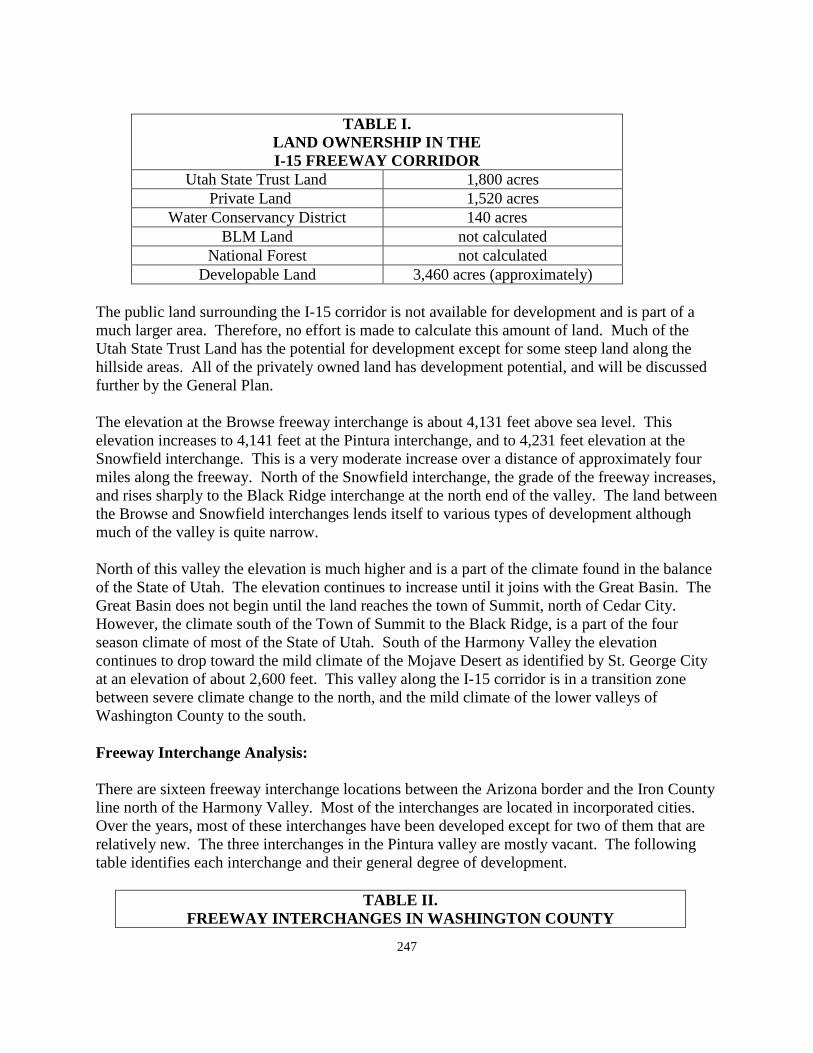
247
TABLE I.
LAND OWNERSHIP IN THE I-15 FREEWAY CORRIDOR
Utah State Trust Land 1,800 acres Private Land 1,520 acres
Water Conservancy District 140 acres BLM Land not calculated
National Forest not calculated Developable Land 3,460 acres (approximately)
The public land surrounding the I-15 corridor is not available for development and is part of a much larger area. Therefore, no effort is made to calculate this amount of land. Much of the Utah State Trust Land has the potential for development except for some steep land along the hillside areas. All of the privately owned land has development potential, and will be discussed further by the General Plan. The elevation at the Browse freeway interchange is about 4,131 feet above sea level. This elevation increases to 4,141 feet at the Pintura interchange, and to 4,231 feet elevation at the Snowfield interchange. This is a very moderate increase over a distance of approximately four miles along the freeway. North of the Snowfield interchange, the grade of the freeway increases, and rises sharply to the Black Ridge interchange at the north end of the valley. The land between the Browse and Snowfield interchanges lends itself to various types of development although much of the valley is quite narrow. North of this valley the elevation is much higher and is a part of the climate found in the balance of the State of Utah. The elevation continues to increase until it joins with the Great Basin. The Great Basin does not begin until the land reaches the town of Summit, north of Cedar City. However, the climate south of the Town of Summit to the Black Ridge, is a part of the four season climate of most of the State of Utah. South of the Harmony Valley the elevation continues to drop toward the mild climate of the Mojave Desert as identified by St. George City at an elevation of about 2,600 feet. This valley along the I-15 corridor is in a transition zone between severe climate change to the north, and the mild climate of the lower valleys of Washington County to the south. Freeway Interchange Analysis: There are sixteen freeway interchange locations between the Arizona border and the Iron County line north of the Harmony Valley. Most of the interchanges are located in incorporated cities. Over the years, most of these interchanges have been developed except for two of them that are relatively new. The three interchanges in the Pintura valley are mostly vacant. The following table identifies each interchange and their general degree of development.
TABLE II. FREEWAY INTERCHANGES IN WASHINGTON COUNTY
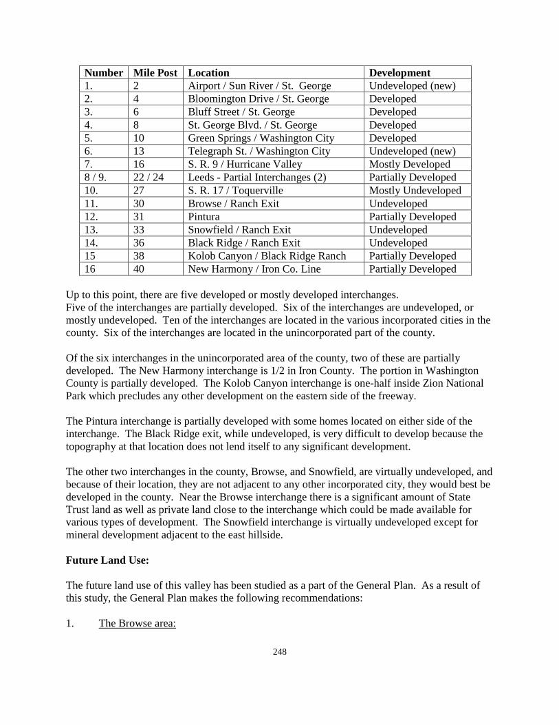
248
Number Mile Post Location Development 1. 2 Airport / Sun River / St. George Undeveloped (new) 2. 4 Bloomington Drive / St. George Developed 3. 6 Bluff Street / St. George Developed 4. 8 St. George Blvd. / St. George Developed 5. 10 Green Springs / Washington City Developed 6. 13 Telegraph St. / Washington City Undeveloped (new) 7. 16 S. R. 9 / Hurricane Valley Mostly Developed 8 / 9. 22 / 24 Leeds - Partial Interchanges (2) Partially Developed 10. 27 S. R. 17 / Toquerville Mostly Undeveloped 11. 30 Browse / Ranch Exit Undeveloped 12. 31 Pintura Partially Developed 13. 33 Snowfield / Ranch Exit Undeveloped 14. 36 Black Ridge / Ranch Exit Undeveloped 15 38 Kolob Canyon / Black Ridge Ranch Partially Developed 16 40 New Harmony / Iron Co. Line Partially Developed
Up to this point, there are five developed or mostly developed interchanges. Five of the interchanges are partially developed. Six of the interchanges are undeveloped, or mostly undeveloped. Ten of the interchanges are located in the various incorporated cities in the county. Six of the interchanges are located in the unincorporated part of the county. Of the six interchanges in the unincorporated area of the county, two of these are partially developed. The New Harmony interchange is 1/2 in Iron County. The portion in Washington County is partially developed. The Kolob Canyon interchange is one-half inside Zion National Park which precludes any other development on the eastern side of the freeway. The Pintura interchange is partially developed with some homes located on either side of the interchange. The Black Ridge exit, while undeveloped, is very difficult to develop because the topography at that location does not lend itself to any significant development. The other two interchanges in the county, Browse, and Snowfield, are virtually undeveloped, and because of their location, they are not adjacent to any other incorporated city, they would best be developed in the county. Near the Browse interchange there is a significant amount of State Trust land as well as private land close to the interchange which could be made available for various types of development. The Snowfield interchange is virtually undeveloped except for mineral development adjacent to the east hillside. Future Land Use: The future land use of this valley has been studied as a part of the General Plan. As a result of this study, the General Plan makes the following recommendations: 1. The Browse area:
249
Land in the Browse area is a combination of Utah State Trust Land and private land. It has remained mostly undeveloped at this time. There has been a proposal to develop a windmill farm on a portion of the State Trust Land. Preliminary plans have been approved by the county, but the project has not moved forward in recent months.
The General Plan recommends that this area be developed in a mixed use pattern of commercial and industrial development. Some residential development in the steeper hillside areas may also fit into this area. A certain number of windmills would fit into this classification if this project moves forward, but the General Plan does not recommend a pattern of windmills extending from Browse to the Black Ridge. Aesthetically, such a pattern of development along the Pintura / I-15 Freeway Corridor would not provide an attractive entrance into Washington County, and therefore should not be encouraged.
Other patterns of development including industry, housing, commercial business such as an outlet mall similar to the type of development found along this same freeway south the City of Barstow, California, would fit well into commercial business as a mixed use in this area. Such a facility was started at the north end of River Road in St. George City, but because it was located in the business area of the city, it has been largely absorbed as a general commercial area.
Such a facility needs to be located outside of the regular commercial center of a city in order to be successful as a true outlet mall. The same fate happened to the outlet mall in the Draper City area of northern Utah. The urban core grew around the mall, and the outlet mall has virtually disappeared. The Pintura / I -15 Corridor would be an ideal location for a large outlet mall. In this location a mall would not be absorbed into the commercial shopping area of an existing city.
2. The Pintura Area:
With the existing homes near the Pintura freeway interchange, the General Plan recommends the future development of this area should be along the lines identified in the Vision Dixie Plan as a mixed residential / commercial center. The location of the town of Pintura is close enough to the "Urban" core of Toquerville, LaVerkin, Hurricane, and Washington City, St. George, Santa Clara, and Ivins, that it could be developed with a mixture of housing types, and convenience commercial businesses, close to the urban core of the county, but not actually a part of this core. It would be similar to the community of Apple Valley to the east, and the communities along the State Highway 18 corridor north of St. George City. The Pintura center would be close to the urban area, but far enough away to maintain a rural character, which could be very attractively developed in the Pintura area.
3. Snowfield:
250
The Snowfield interchange also has some of the same potential for development as the Browse interchange to the south. The valley is not quite as wide, and has one other element that lends itself to Industrial development. The area on the easterly side of the Interstate Freeway abuts the base of the steep hillside, the top of which is a designated wilderness area. In Washington County, mineral development is where you find it and one of the major areas of the county providing mineral products to the county is located along the base of this steep hillside. The area along the steep hills, through this area, coupled with the base of the Hurricane Cliffs running southward through Hurricane toward the Arizona border, is currently the major source of mineral development, meaning gravel, to support the growth and development of the remainder of the county. The land in the Snowfield area is mostly private property which does not require obtaining approval from the Federal Agencies before the resource can be developed.
The I-15 Freeway corridor is a major transportation corridor between the Los Angeles Basin, Northern Utah, Idaho and Wyoming, Colorado, and points east. Many of these loads need to be "broken" and re-loaded to go in one or another of these directions based on the I-70 Interchange further north. The corridor through the Pintura area would provide a great opportunity for warehousing in a snow free area where these loads could be stored, re-routed and sent north or eastward. The General Plan recommends that this valley is perfectly located for this type of business to take place at either the Snowfield or the Browse freeway interchange.
The General Plan recognizes this source of gravel as a major resource in the county that must be protected and allowed to develop. Even near the proposed mixed use area at the Pintura interchange, mineral development along the base of the hillside east of the freeway is a use that must be integrated into the mixed residential /commercial development of this potential community center.
The policy of Washington County has historically been to encourage development to annex into one of the communities in the county when it is close by rather than remaining in the county, and competing with the adjacent community to provide public services to developing areas. As a result, the commercial and industrial sales tax base of the county is largely included in one or another of the incorporated cities. The I-15 Freeway Corridor provides the opportunity to develop the three freeway interchange locations along this corridor that have remained undeveloped since the construction of the freeway through Washington County. With most of the other interchanges already being developed, this area provides the county an opportunity to benefit from future development at three of the last undeveloped freeway interchange locations in the county. There are opportunities for development in a mixed use manner in this area that does not exist at either of the two other new interchanges in St. George City at mile post 2, and Washington City at mile post 13 respectively. Public Services:
251
A section of the General Plan dealing with pubic services county-wide is located in Section VII of the General Plan. This section of the plan will be adopted in connection with the adoption of the various community plans and is not currently part of the General Plan. Some comments specific to this area of the county are discussed here as they relate specifically to this part of the county. One of the reasons that development has not taken place along this part of the interstate system in Washington County prior to this time has been the lack of public services which Washington County has not provided to this or any other area of the county prior to this time. This area of the county can now be developed with a minimum of county involvement which was not previously available. Following is a list of some of the public services that would be required in this area to provide for the development suggested by the General Plan. Electricity: Electric service to this part of the county is provided by the Rocky Mountain Power Company. "Rocky Mountain" has been working very hard in the past few years to update and expand their ability to provide service to Washington County. With the addition of another major transmission line to the county, and the expansion of other service lines to parts of the county, the Rocky Mountain Power Company is in a position to provide power for significant growth and development in the future in all parts of the county where they have a service area. Water The availability of water has been one of the major drawbacks to development along this freeway corridor since the freeway was originally constructed. This was the first section of the interstate freeway to be completed in the county. Water could now be brought to this area by the Washington County Water Conservancy District from wells located in the Anderson Junction area, which already provide water to Virgin Town, Toquerville, and LaVerkin City. The construction of a new reservoir in this area, along with the additional wells being added, could provide a stable source of culinary water to this part of the county at any time the demand justifies extension of development lines. Sewage Disposal: The small amount of development that has previously taken place in this valley has utilized septic tanks for development. Depending upon the exact type of development in the industrial / commercial mixed use areas of the valley, septic tanks might still be an adequate method of sewage disposal. However, other means of disposal are now approved by the State Department of Environmental Quality which could provide service to the mixed use commercial / residential area that the General Plan suggests for the Pintura area.
252
Because the county now has an agreement with the Ash Creek Special Service District to oversee sewage disposal in this part of the county, a future connection to the existing Sewer District could also be an option sometime in the future. Roads: In the Pintura valley of the county, the only road of any consequence is the Interstate Freeway. Most other existing roads are unimproved roads that serve various developments or residences along the freeway corridor. Additional roads will be needed to serve the development that could come in the future. These roads can be planned and developed in conjunction with developments that are proposed to take place. The General Plan would also recommend that when development takes place near the existing freeway, that sufficient right of way for widening of the interstate be reserved as a part of development near the current freeway right-of way. Frontage road widths should also be required so that local traffic can travel up and down the valley without the need to travel on the freeway. Public Safety: Public safety to the valley is provided by the Washington County Sheriff's Office. This method of law enforcement and police protection will continue to be provided and expanded as necessary to meet the needs of the area. The Utah Highway Patrol will continue to provide an additional police presence along the freeway right-of-way. Solid Waste: The Washington County Solid Waste Board is made up of one representative from each city and town along with one member from the county. This committee oversees the collection of solid waste in the county. There is a central landfill location which is owned by Washington County and managed by the solid waste collection company. This site is expected to be sufficient for many years to come. The system of management and oversight is also expected to continue. The solid waste program in the county is supported by the General Plan and currently works very well. The Plan recommends that this system continue to be used for development in this part of the county. Building Inspection: Building inspection for all types of construction is provided by the County Building Department. This Department is prepared to inspect commercial and industrial development as well as residential development. The cost of building permits is established to defray the cost of inspection during the period of construction. Building permit fees in the unincorporated areas of the county are generally lower than those found in the incorporated cities and towns in the county.
253
Communication: Most of Washington County is served by the Century Link communication company. In addition to Century Link services, there are a number of private cellular companies providing service in the county. Because of the proximity of any development to the Interstate Freeway, it can be expected that most cellular systems will be available in this area. One cellular tower does exist near the Browse Interchange, and two other towers have been approved south of the Black Ridge interchange on the hillside above the freeway. Flood Control: Flood control has not been identified as a major problem along the freeway through this part of the county. Proper drainage will need to be a consideration in the approval of any construction plans for buildings in the valley, especially for large box storage or industrial buildings that may be constructed. Incorporation: This is currently an unincorporated part of the county. It is the one area of the county where annexation or incorporation is not expected in the future, and should be opposed by the county should it be proposed. Toquerville, with City limits including the Anderson Junction freeway interchange, could possibly propose to annex up through the Snowfield Interchange. The General Plan recommends that this area of the county remain unincorporated to provide the county with ``a commercial and industrial sales tax base that has not already been brought into one of the other incorporated areas of the county.
254
THE VEYO COMMUNITY GENERAL PLAN 2010 - 2011
Introduction: Veyo is an unincorporated part of Washington County. Residents and others should take time to review Section I of the Washington County General Plan which discusses planning in general, the basis for planning, and the purpose of planning. Many of the things mentioned in the beginning of Section VII are also relevant to residents of this part of the county. The General Plan of the Veyo community provides guidelines for the future for this particular part of the county in addition to those things that are applied county wide in the other sections of the General Plan. In 1911, James L. Bunker filed on water from the Santa Clara and a homestead of 160 acres. He was joined by John Hunt who also filed on 160 acres, and Step hen Bunker did the same. In addition, James Cottam Albert Bunker filed on land south of the Santa Clara.
255
In 1914, James L. Bunder moved his family onto his 160 acre parcel and was the first resident of the community. James F. Cottam also moved his family to the area in 1914 and was the first family to stay permanently on the land. The Homestead Act allowed a person to file on 160 acres of land, and if they were able to live on the land for three years after paying a $16.00 fee, you could then acquire an additional 160 acres for the rate of $1.00 per acre. Over the years Veyo has developed as a quiet, agricultural and livestock raising community. In the 1971 County General Plan, Veyo showed a population of 95 residents. Over the past forty years, Veyo has continued to grow and develop as a quiet community and a desirable place to live and raise a family. The early residents could not get approval for the chosen name for the community so turned over the task of naming over to the "Beehive" girls. From two Bee Hive words, verdure and youth, came the name Veyo by taking the first two letters from each word, it was readily accepted. Geography and topography: Veyo is centrally located along the western corridor of Washington County. With Winchester Hills, Diamond Valley, and Dammeron Valley located to the south of Veyo, Brookside, Central/Dixie Deer, and Pine Valley to north and east, and Gunlock to the west, Veyo is located in the center and crossroads of the "west side" development in Washington County. Veyo is located almost mid-way between the City of St. George, and the City of Enterprise along State Highway 18 running between these two cities in Washington County. With all of the above factors in place, the Veyo community is well positioned to play an important role in any significant future development along the west side of the county. Veyo was developed over the years as basically an agriculturally based valley. There are still many large, open space, agricultural and livestock oriented areas in the Veyo valley. Unlike many of the other unincorporated communities in the county, Veyo is not closely surrounded by public land. The valley itself is privately owned without public lands taking up much of the valley area. There is a small amount of land in the valley under the jurisdiction of the State and Institutional Trust Lands along with some land controlled by the Utah Department of Wildlife Resources. Most of the other land in the valley is privately owned. Table I on the following page identifies the land ownership in the valley and the approximate amount of land under the jurisdiction of each land ownership.
Table I Land Ownership / Management in Veyo
State of Utah - Trust Land + UDWR 39.20 acres 0.06 sq. miles Private, vacant, quasi public land 2,416.82 acres 3.78 sq. miles
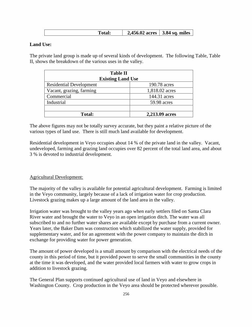
256
Total: 2,456.02 acres 3.84 sq. miles Land Use: The private land group is made up of several kinds of development. The following Table, Table II, shows the breakdown of the various uses in the valley.
Table II Existing Land Use
Residential Development 190.78 acres Vacant, grazing, farming 1,818.02 acres Commercial 144.31 acres Industrial 59.98 acres
Total: 2,213.09 acres
The above figures may not be totally survey accurate, but they paint a relative picture of the various types of land use. There is still much land available for development. Residential development in Veyo occupies about 14 % of the private land in the valley. Vacant, undeveloped, farming and grazing land occupies over 82 percent of the total land area, and about 3 % is devoted to industrial development. Agricultural Development: The majority of the valley is available for potential agricultural development. Farming is limited in the Veyo community, largely because of a lack of irrigation water for crop production. Livestock grazing makes up a large amount of the land area in the valley. Irrigation water was brought to the valley years ago when early settlers filed on Santa Clara River water and brought the water to Veyo in an open irrigation ditch. The water was all subscribed to and no further water shares are available except by purchase from a current owner. Years later, the Baker Dam was construction which stabilized the water supply, provided for supplementary water, and for an agreement with the power company to maintain the ditch in exchange for providing water for power generation. The amount of power developed is a small amount by comparison with the electrical needs of the county in this period of time, but it provided power to serve the small communities in the county at the time it was developed, and the water provided local farmers with water to grow crops in addition to livestock grazing. The General Plan supports continued agricultural use of land in Veyo and elsewhere in Washington County. Crop production in the Veyo area should be protected wherever possible.

257
Land owners involved in farming should make certain that their land is classed in a green belt classification to protect against increases in land value until such time as the land is sold. If farming is a nuisance to neighbors, the land may be placed in an agricultural protection classification which gives protection for the continuance of necessary agricultural operations in the event that non-agricultural development takes place nearby. In more recent years, conservation easements have been placed on agricultural land which allows the owner to continue with agricultural use of their land and, at the same time, compensate them for value that they might otherwise receive by selling the land for development. The residents of the community have strongly supported the continued use of land for agricultural purposes. The above methods, along with others that may be suggested, should be followed in the protection of the agricultural base of the community. The amount of irrigation water in Veyo is limited. All of the water was subscribed to and allocated at the time the Dam was constructed. Some shares have been sold to others over the years, but there is not enough irrigation water in the valley to irrigate all of the land that could be used for farming. As a result, much of the land is, instead, used for livestock raising and to provide grazing for livestock animals. Residential Development and population considerations: There are currently 73 building lots in recorded subdivisions in Veyo. There are only three recorded subdivisions in the valley. These include the following:
• Old Spanish Trails Subdivision which was recorded in 1973 and contains 43 lots. • Lava Ridge Subdivision which was recorded in 1974 and contains 18 lots. • Chadburn Subdivision which was recorded in 1979 and contains 11 lots.
Three of those lots have been divided into 5 additional lots. In these three subdivisions there are currently 11 vacant lots in Old Spanish Trails Subdivision, 4 vacant lots in the Lava Ridge subdivision, and 16 vacant lots in the Chadburn Subdivision, for a total of 31 vacant lots in the three subdivisions. This leaves a total of 42 homes in the existing subdivisions. There have been a number of lots sold be metes and bounds outside of the three subdivisions. This number is somewhere in the range of 45 additional lots with homes on them in the Veyo valley. These numbers total about 42 homes in the three subdivisions along with 45 outside the subdivisions for an approximate total of 86 dwelling units in Veyo. The average family size in Veyo according to the completed questionnaires is 4 members per family. This is about one person per family greater than the county average. Using the county average of about 3 residents per dwelling unit, it would project a current population in Veyo of about 258 residents. Using an average family size of 4, the population would be about 348 residents.
258
Over the past ten years there have been 40 building permits issued in the Veyo area. If this same pattern continued for the next ten years, the community of Veyo could expect to have an additional 120 to 160 new residents over the next ten year period. There are currently 31vacant building lots in the existing Veyo subdivisions. This would provide 90 - 120 residents if no new development happens, and only the existing lots are built on. Rarely do subdivisions build out to a 100% density total. There have been no new residential developments in the community of Veyo since 1979. One of the reasons for little growth over the past ten years is a lack of culinary water. Many of the surrounding communities have been developed in whole or in part since 1979. With all of the new development in Washington County in the past 40 years, it could be viewed as a little strange that such an attractive valley as the Veyo valley would have no new subdivision during the last 30 or 40 years. If sufficient water was available to support development and growth, it could be expected that there would have been significantly more growth than has actually taken place. Population Density: The projection of existing population and projected population are discussed above. The projected population above shows one of the lowest population densities of any of the unincorporated communities in the county. With a population of 250 to 350 residents and a land area of 2,213 acres, the density is over 7 acres per dwelling unit. That is a very low density by any standard of measurement. . Vision Dixie Summary: According to the responses from the questionnaire circulated in the community, only a few of the residents participated in the Vision Dixie Study that was undertaken by the county a few years ago. The outgrowth of the study and recommendations by the committee charged with reviewing the material collected was a series of guidelines and policies aimed at guiding future growth in the county. The summary of the Vision Dixie study, adopted by the county and most of the incorporated cities and towns in the county is summarized for the residents of Veyo as follows: 1. Plan Regionally, Implement locally - The General Plan for Veyo is a locally prepared
plan for this area of the county only, and is a part of the overall county General Plan. It deals with aspects of the future of Veyo and may be amended from time to time as necessary, dealing with the concerns of the Veyo community and not the county at large.
2. Maintain air and water quality, and conserve water - The Veyo area has a high standard
of air quality. The low population density of Veyo and the separation of Veyo from other more urban areas of the county, help to maintain good air quality in Veyo. Water
259
conservation is necessary in Veyo because of the limited amount of water that is available in the community.
3. Guard our signature landscapes - With one exception, the surrounding hillsides of Veyo
are maintained in an open space category on public land. Some years ago, the natural gas company requested construction of a pressurization station on the hillside west of Veyo, and received permission for the construction of this station. It is visible from the community of Veyo, and should not have been approved in that location. With the Vision Dixie Principles in place, it can be expected that there will be no further developments approved in the Veyo community view-shed.
4. Provide connected natural recreation areas and open spaces - This is covered by the
previous item in protection of the view-shed surrounding the valley. It should be protected and maintained.
5. Build a balanced transportation system. - There is presently no public transportation
system serving the Veyo community. Public transportation may sometime come between St. George City and Enterprise City. If such transportation system was in existence, Veyo would obviously be involved. At this point in time, such service will not likely take place during the period of this General Plan.
6. Get centered by focusing on growth in walk-able mixed use centers - The center of Veyo
is walkable, under the Vision Dixie Principles, to many of the residential dwellings in the valley. The study recommended that all dwellings should be within three-quarters of a mile from a commercial center. If the entire valley is developed, additional commercial centers should exist at various points within the valley. Further discussion of commerce in Veyo will be discussed following in the section dealing with commercial development.
7. Direct growth inward - This policy is generally being followed in Veyo. Within the Veyo
valley, residential development is generally contained to those areas of the valley adjacent to the State Highway and the country road that intersect in the center of the residential portion of the valley. Other development, if additional development takes place in the future, should be encouraged to grow outward from the "center" of the current growth area and not to "leapfrog" to far corners of the valley with no infill of development in between.
8. Provide a wide range of housing types - This policy works well in the urbanized portions
of the county where sewer service is available. In Veyo, where homes are on septic tanks for waste disposal, these septic tanks would not support large blocks of multiple family dwellings. A sewer system for waste disposal is not needed in Veyo at this point of time.
9. Reserve areas for industry - Veyo identified areas for industrial development that are
located in an area away from the residential development in the community. The type of industry which includes cinders and rock products seems to work well in the area in which it is located. These industries do not require freeway access on a regular basis
260
which makes it possible for them to work well in the Veyo community. Most of the unincorporated communities in the county are basically a subdivision development. This is not the case of development in Veyo.
10. Public Land Conversion - The Veyo valley is made up of private property. The public
land surrounding the valley has not been identified as being necessary to the future growth and development of the Veyo community.
Commercial Development: One goal of the Vision Dixie Plan is to try to make communities as sustainable as possible. This means that residents should be able to find work where they live, and that circulation through the community might be better with walking and bike trails as opposed to automobiles. Relative to commercial development in Veyo, the questionnaires returned by the residents attending the planning meeting held in Veyo last summer indicated that there was mixed feelings relative to commercial development in the community. Many suggested that no more commercial development was needed, and others suggested a rather broad range of additional commercial facilities that they would like to see developed in Veyo. One interesting fact that has been revealed through the General Plan process in surrounding unincorporated communities is that while most of these areas have very little; if any, commercial development of their own, most recommended that future commercial development take place in Veyo or St. George. South of Veyo is three other communities, Winchester Hills, Diamond Valley, and Dammeron Valley. North of Veyo is three other communities including Pine Valley, Central/Dixie Deer, and Brookside/Pine Valley Mountain Farms. To the west of Veyo lies the community of Gunlock. Each of the areas identifies Veyo as a potential commercial area to serve their community. Based upon the Vision Dixie Plan, Satellite commercial areas are needed to support commercial centers. Obviously St. George is a major commercial center in Washington County. By the same token, Veyo fits the model rather perfectly as a satellite commercial center to serve a certain section of the county. There may be some question as to just where there is sufficient land available to provide for additional commercial development in the Veyo community, in addition to the development that already exists at the major intersection with State Highway 18 and the county road to Gunlock. The General Plan recommends that Veyo be identified as a satellite commercial center for the communities making up the "west side" of Washington County. The community may want to survey the area to determine how much additional commercial development could take place near the center of the existing community, or where in proximity to this area additional development could take place. The residents of Veyo should keep in mind the fact that commercial development is largely determined by economics. When someone determines that there is a sufficient demand for a
261
certain commercial business, they will seek to develop that particular business. Until someone decides that there is economic potential for a business, no development will take place. There is currently no rush to develop in Veyo. Industrial Development: Industrial development in Veyo in terms of a typical industrial park development containing a cross section of industrial businesses does not exist in Veyo, and is not expected to take place. Industrial development, in normal terms, requires transportation from the industrial site to the market. Most industrial industry areas require access to ground transportations (freeways), or air transportation (airports). Veyo does not have ready access to either of these basic needs. Industry in Veyo is tied to natural resources that are available in the surrounding area, and are not tied to either large truck transportation or air transportation to sell the product that is being developed at industrial sites in Veyo. The existing business fit the location in Veyo, and the General Plan recommends that those types of industries that are compatible with the industrial surroundings continue to be encouraged to locate in the Veyo industrial area. Public Services: A section on public services, as they relate county-wide, is found at the beginning of Section VII of the Washington County General Plan. Some comments that may specifically relate to the Veyo valley are re-stated here as they relate specifically to this community. Electricity: Electric service to Veyo is provided by the Rocky Mountain power company. This company has recently upgraded their distribution lines from the Red Butte distribution center. They are in the process of upgrading their main distribution line from the sub-station at Sigurd, Utah, to the Red Butte sub-station located near the Central/Dixie Deer community. With this upgrade in place, the power company feels that it will be in a position to provide electrical service to the west side of the county for a long time to come. The residents of Veyo generally gave their electrical system good marks in terms of reliable service to the community. The ability to provide good service to the residents of Veyo should continue for many years to come. Natural Gas: There is a major natural gas distribution line that currently parallels State Highway 18 and runs between the Red Butte sub-station near the Central/Dixie Deer community, and joins a comparable line coming into the county from the east side of the Pine Valley Mountains that serves communities on the east side of the county and which come together in the St. George area. These lines provide a stable source of natural gas to the county and to most of the communities therein. Water:
262
Water to the Veyo community is provided by a private water company who sells shares to land owners who request to purchase shares. The owners of the water shares become the owners of the water company. The water company obtains most of the culinary water from springs located to the north and east of the valley, and stores water in four different storage tanks located at various points throughout the valley. Water from the Veyo Water Company also provides water to a part of the Brookside subdivision. The Pine Valley Mountain farms water company also provides water to a portion of the Brookside subdivision. The limited amount of water available for purchase is the single most limiting factor to additional development in Veyo. The Washington County Water Development District has talked from time to time about running a water line along Highway 18 going north from St. George to serve communities along such a line. The intent of the District is to provide supplementary water to communities who need additional water in the case of a breakdown in their local system, or to support additional development. The General Plan does not recommend that water systems be turned over to the Water District, but that they would be able to purchase supplementary water and add it to their systems should the need arise. There is a limited amount of irrigation water available to some parts of the Veyo area. This water is limited to the extent that it does not allow for unlimited farming throughout the valley. All irrigation water is currently in use. The irrigation water does provide for farming on a limited basis in the valley. There is no un-appropriated water in any part of the county, including the Veyo area. Sewage Disposal: This public service has been discussed previously. Veyo is served by individual septic tanks for all homes and businesses in the valley. Based on the recommendations of the county-wide wastewater report adopted some years ago, Veyo can continue to develop using septic tanks for many years to come as long as lots are of sufficient size for adequate outfall lines for septic tanks. Septic tanks should be inspected on a regular basis and pumped or outfall lines replaced as necessary to keep the system working well. On site treatment facilities are now available as a viable alternative to a sewage collection system. This could some day be an option for the Veyo area in the event that substantial residential or commercial development takes place at some time. Roads: There is a combination of road designations in Veyo. The major highway running through town, State Highway 18, is managed by the Utah Department of Transportation as a State Highway. Little by little, UDOT has been widening this highway to improve traffic movement, particularly moving northward out of St. George, for some time. Over time, this widening should continue all the way to the City of Enterprise, or at a minimum to the Pine Valley turn off in Central.
263
It may be difficult to widen this highway to four lanes through the central part of Veyo, but it could be needed as the volume of traffic continues to increase from north to south in Washington County. One major county road exists through the community of Veyo. This is the county road that runs westward from Veyo to Gunlock. Widening of this highway from two to four lanes is not anticipated at any time in the future of the General Plan for Veyo, and with minimum improvements over time, should be sufficient to serve the commuting needs between Veyo and Gunlock. Other county roads include the local street system in the Veyo area. Most of these roads have been paved and are maintained in that condition by the county. This maintenance level should be continued. The policy of the county for many, many years has to maintain county roads in the same condition and degree of improvement that they were in at the time the subdivisions were recorded. The Lava Ridge subdivision falls into that category. For whatever reason, that road was dedicated but accepted without being paved. It will be maintained in that condition unless and until such time as land owners along that roadway cause the road to be improved, after which time the county will maintain the road in the improved condition. Veyo also has one subdivision, Old Spanish Trails, which has private streets. These streets were left as private streets at the time the subdivision was developed at the request of the developer. Therefore, they are not maintained by the county. Some requests come from time to time to have the county accept dedication of these roads. If that happened, they would be maintained in the same condition as they are today. There are some benefits to private roads. Usually traffic is less on private roads. As areas for people to go to walk without higher traffic levels, they can be very attractive. There may be good reason for the property owners in this subdivision to keep the roads private. Or, on the other hand, a small assessment to the property owners could provide funds for minimum improvement to these roads, as necessary, and they may be very satisfactory as private roads which they have been for some forty years now. Fire Protection: The community of Veyo operates its own volunteer fire department. It is a part of the North West Fire District. In recent years, Veyo has constructed a new fire station located on the north side of Center Street just a little way east of the center of town. The volunteer department participates with the Washington County Fire Chief's Association. The 10 volunteer members of the department participate in training with the District.
264
The new fire station contains one pumper truck and two brush trucks. The department has also obtained safety equipment for the use of the volunteers during actual fire fighting. The Veyo department is also on call to assist with fires outside of the Veyo area as may be needed to assist fire departments elsewhere in the county. The department continues to make efforts to improve and enlarge to meet the needs of the Veyo area. Public Safety: Police protection in Veyo is provided by the Washington County Sheriff's Office. This service will continue as long as Veyo continues as an unincorporated part of Washington County. Some communities in the county desiring greater protection have contracted with the county to increase the amount of sheriff's visibility in their community through a specific contract calling for more sheriffs’ protection in exchange for additional funds being raised by the community. Solid Waste: The county solid waste board is made up of one representative from each city or town, along with one member from the county, oversee the collection of solid waste in the county. This board contracts with a private company to provide the collection of waste in the county. There is a central landfill location which is owned by Washington County and managed by the solid waste company. This site is expected to be sufficient for many years to come. The system of management and oversight is also expected to continue. Overall, the solid waste program in Washington County is recommended by the General Plan and currently works very well. Building Inspection: Building inspection for dwelling units and other types of building construction are provided by the county building department. The cost of building permits is established to defray the cost of inspection during the period of construction. Building permit fees in the unincorporated communities are significantly less than found inmost of the incorporated cities and towns in the county. Communication: Most of Washington County is served by the CenturyLink communication company. In addition to CenturyLink services, there are a number of private cellular companies providing service within the county. Citizen response to the planning questionnaire resulted in a mixed response to the question of cellular services. This undoubtedly depends upon what cellular system a person uses. However it would appear that the communications in Veyo are generally adequate, with the General Plan recommending that communication providers continue to upgrade their services to the Veyo area. Flood Control:
265
Veyo appears to be one community in the county that is not severely impact with flooding problems. The Santa Clara River canyon through the Veyo area is generally quite deep which tends to minimize the problem of flooding. Cemetery, Parks, and Recreation: A cemetery in Veyo is located towards the easterly end of town and is maintained in connection with a park site that exists adjacent to the cemetery. The adjacent park site has been developed by residents of the community and provides a certain need for park and recreation development in the community. The current park and cemetery are located on land obtained by Washington County many years ago through the Recreation and Public Purpose Policy Act, when the county obtained a 40 acre site in the Veyo community to allow the community to develop additional recreation facilities. The county would deed the park to a body politic, if one existed, with the intent that the residents of the community would work collectively to develop additional park and recreation facilities in the area. The majority of the land is located north of the road that intersects the land with the park and cemetery on the south side of the road and the balance of the land on the north side. The questionnaires submitted to the county as a part of the General Plan project listed a number of facilities that they would like to see developed in Veyo. Many, if not all, of the recommended facilities could be accommodated on the 40 acre tract of land that is being held for recreation purposes. The location of this parcel of property is north, across the street, from the current park and cemetery property. There are also two privately owned sites in Veyo were recreation activities are available. One of these is an arena facility located north of the community center where equestrian activities are held from time to time. The other site is the well known Veyo Pool, located south of the Santa Clara River and east of the State Highway. The Veyo Pool property was homesteaded by the Cottam family, and a warm spring was found coming out of the black lava canyon which was on the property. The family took three years to construct a family pool. A year and one-half later, it was changed to a public pool with a .15 cent admission price. Over the years it was enlarged a couple of time to its current size of 28 feet by 70 feet. The Pool development has been one of the well known recreation sites for swimming, picnicking, and other recreation activities in the county, and was the one thing that made Veyo a well known community. For many years it was the only public swimming pool in Washington County. As other facilities have developed in recent years, the Veyo Pool has diminished in prominence, but for many, many, years the pool served as a prime recreation site for residents of Washington County. Incorporation:
266
One final issue related to public services is the question of incorporation. Under Utah State law, a petition for incorporation must originate from within the community that desires to pursue this alternative. Whether or not this is an alternative that should be considered further is a decision of the residents of Veyo. Incorporation has been considered once or twice in past years, but has not reached fruition. The county does not promote incorporation, nor does it oppose incorporation. That is a decision that is left totally up the residents of the area where incorporation is being discussed or considered. The county does feel that government that is closest to the people is the best form of government. Veyo does have a minimal local tax base that could help support incorporation, and this tax base will likely continue to increase as the satellite commercial concept for the Veyo continues to grow in coming years. In each area of the county where planning meetings have been held with the residents, it has been expressed that the residents would like to keep things just as they are. Physically, most of these unincorporated areas have changed very little over a long period of time. However, the residents of these communities continue to grow older, and in most cases, the replacement by new younger families does not take place. Therefore, to keep things just as they are is something that is not possible to happen. The question is not whether things change, but rather, "Will we as citizens of a given area be prepared to give direction and input to change when it happens, or will we sit back and wait until something happens, and then wish that we bad been able to do something about the change after it has taken place." To be aware of what is happening, and to give citizen input to projected change before it takes place is the opportunity for the residents of this community as a result of the General Plan study that is contained herein.
WASHINGTON COUNTY COMMUNITY STATISTICAL SURVEY FOR
THE COMMUNITY OF VEYO 2010 - 2011
1. Residency status: a. How long have you lived in this area? 14 years average
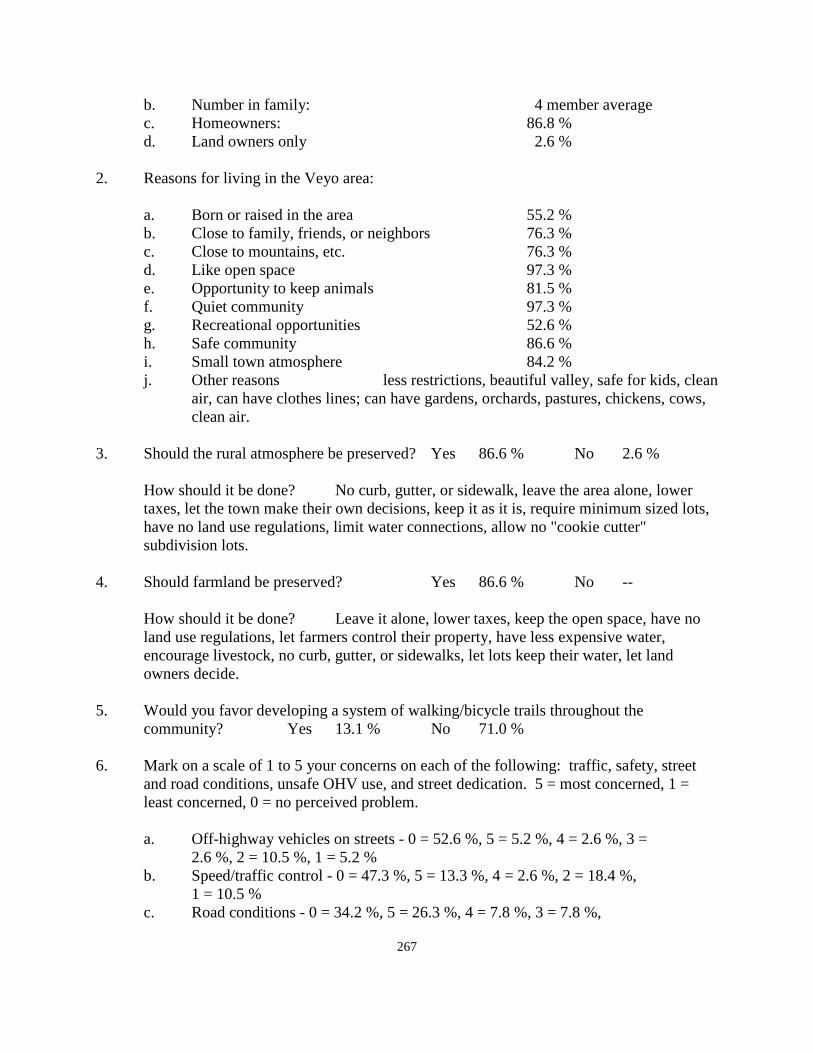
267
b. Number in family: 4 member average c. Homeowners: 86.8 % d. Land owners only 2.6 % 2. Reasons for living in the Veyo area: a. Born or raised in the area 55.2 % b. Close to family, friends, or neighbors 76.3 % c. Close to mountains, etc. 76.3 % d. Like open space 97.3 % e. Opportunity to keep animals 81.5 % f. Quiet community 97.3 % g. Recreational opportunities 52.6 % h. Safe community 86.6 % i. Small town atmosphere 84.2 %
j. Other reasons less restrictions, beautiful valley, safe for kids, clean air, can have clothes lines; can have gardens, orchards, pastures, chickens, cows, clean air.
3. Should the rural atmosphere be preserved? Yes 86.6 % No 2.6 % How should it be done? No curb, gutter, or sidewalk, leave the area alone, lower
taxes, let the town make their own decisions, keep it as it is, require minimum sized lots, have no land use regulations, limit water connections, allow no "cookie cutter" subdivision lots.
4. Should farmland be preserved? Yes 86.6 % No -- How should it be done? Leave it alone, lower taxes, keep the open space, have no
land use regulations, let farmers control their property, have less expensive water, encourage livestock, no curb, gutter, or sidewalks, let lots keep their water, let land owners decide.
5. Would you favor developing a system of walking/bicycle trails throughout the community? Yes 13.1 % No 71.0 % 6. Mark on a scale of 1 to 5 your concerns on each of the following: traffic, safety, street
and road conditions, unsafe OHV use, and street dedication. 5 = most concerned, 1 = least concerned, 0 = no perceived problem.
a. Off-highway vehicles on streets - 0 = 52.6 %, 5 = 5.2 %, 4 = 2.6 %, 3 = 2.6 %, 2 = 10.5 %, 1 = 5.2 % b. Speed/traffic control - 0 = 47.3 %, 5 = 13.3 %, 4 = 2.6 %, 2 = 18.4 %, 1 = 10.5 % c. Road conditions - 0 = 34.2 %, 5 = 26.3 %, 4 = 7.8 %, 3 = 7.8 %,
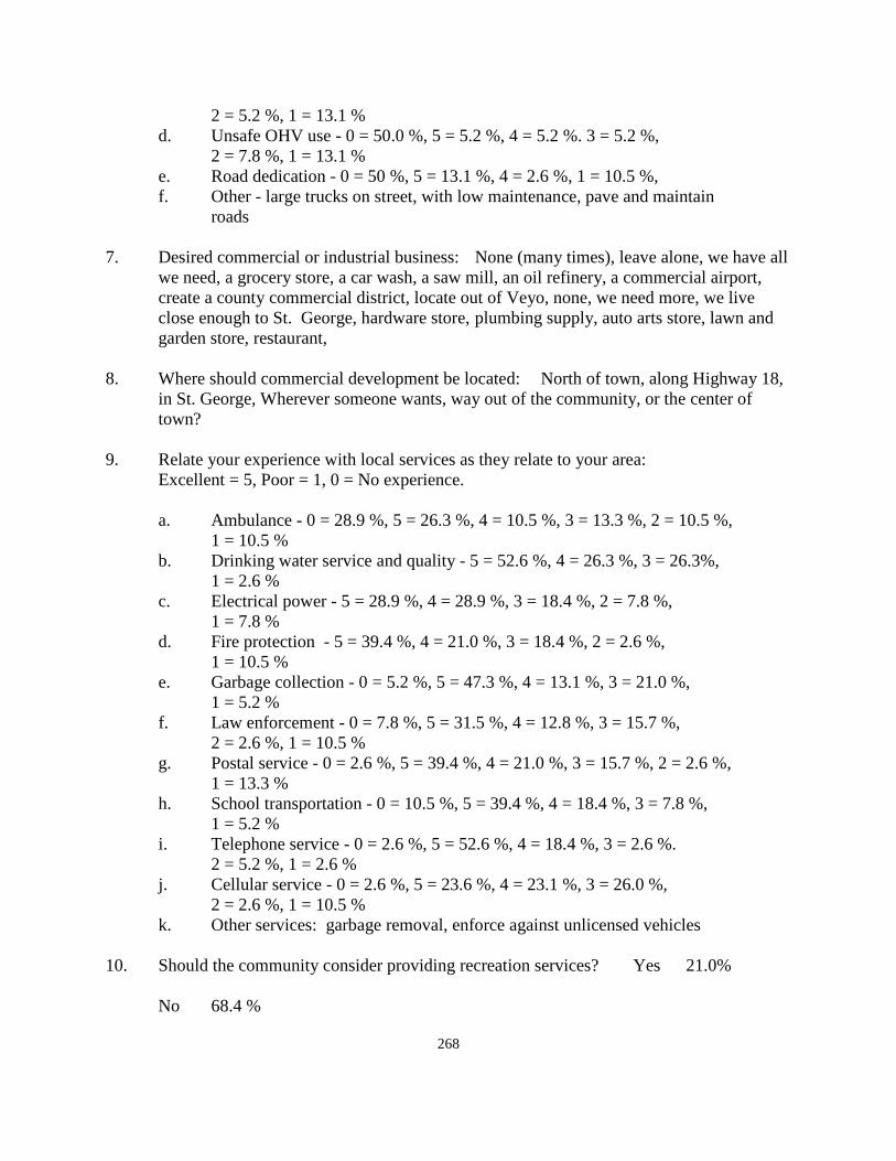
268
2 = 5.2 %, 1 = 13.1 % d. Unsafe OHV use - 0 = 50.0 %, 5 = 5.2 %, 4 = 5.2 %. 3 = 5.2 %, 2 = 7.8 %, 1 = 13.1 % e. Road dedication - 0 = 50 %, 5 = 13.1 %, 4 = 2.6 %, 1 = 10.5 %, f. Other - large trucks on street, with low maintenance, pave and maintain roads 7. Desired commercial or industrial business: None (many times), leave alone, we have all
we need, a grocery store, a car wash, a saw mill, an oil refinery, a commercial airport, create a county commercial district, locate out of Veyo, none, we need more, we live close enough to St. George, hardware store, plumbing supply, auto arts store, lawn and garden store, restaurant,
8. Where should commercial development be located: North of town, along Highway 18,
in St. George, Wherever someone wants, way out of the community, or the center of town?
9. Relate your experience with local services as they relate to your area: Excellent = 5, Poor = 1, 0 = No experience. a. Ambulance - 0 = 28.9 %, 5 = 26.3 %, 4 = 10.5 %, 3 = 13.3 %, 2 = 10.5 %, 1 = 10.5 % b. Drinking water service and quality - 5 = 52.6 %, 4 = 26.3 %, 3 = 26.3%, 1 = 2.6 % c. Electrical power - 5 = 28.9 %, 4 = 28.9 %, 3 = 18.4 %, 2 = 7.8 %, 1 = 7.8 % d. Fire protection - 5 = 39.4 %, 4 = 21.0 %, 3 = 18.4 %, 2 = 2.6 %, 1 = 10.5 % e. Garbage collection - 0 = 5.2 %, 5 = 47.3 %, 4 = 13.1 %, 3 = 21.0 %, 1 = 5.2 % f. Law enforcement - 0 = 7.8 %, 5 = 31.5 %, 4 = 12.8 %, 3 = 15.7 %, 2 = 2.6 %, 1 = 10.5 % g. Postal service - 0 = 2.6 %, 5 = 39.4 %, 4 = 21.0 %, 3 = 15.7 %, 2 = 2.6 %, 1 = 13.3 % h. School transportation - 0 = 10.5 %, 5 = 39.4 %, 4 = 18.4 %, 3 = 7.8 %, 1 = 5.2 % i. Telephone service - 0 = 2.6 %, 5 = 52.6 %, 4 = 18.4 %, 3 = 2.6 %. 2 = 5.2 %, 1 = 2.6 % j. Cellular service - 0 = 2.6 %, 5 = 23.6 %, 4 = 23.1 %, 3 = 26.0 %, 2 = 2.6 %, 1 = 10.5 % k. Other services: garbage removal, enforce against unlicensed vehicles 10. Should the community consider providing recreation services? Yes 21.0% No 68.4 %
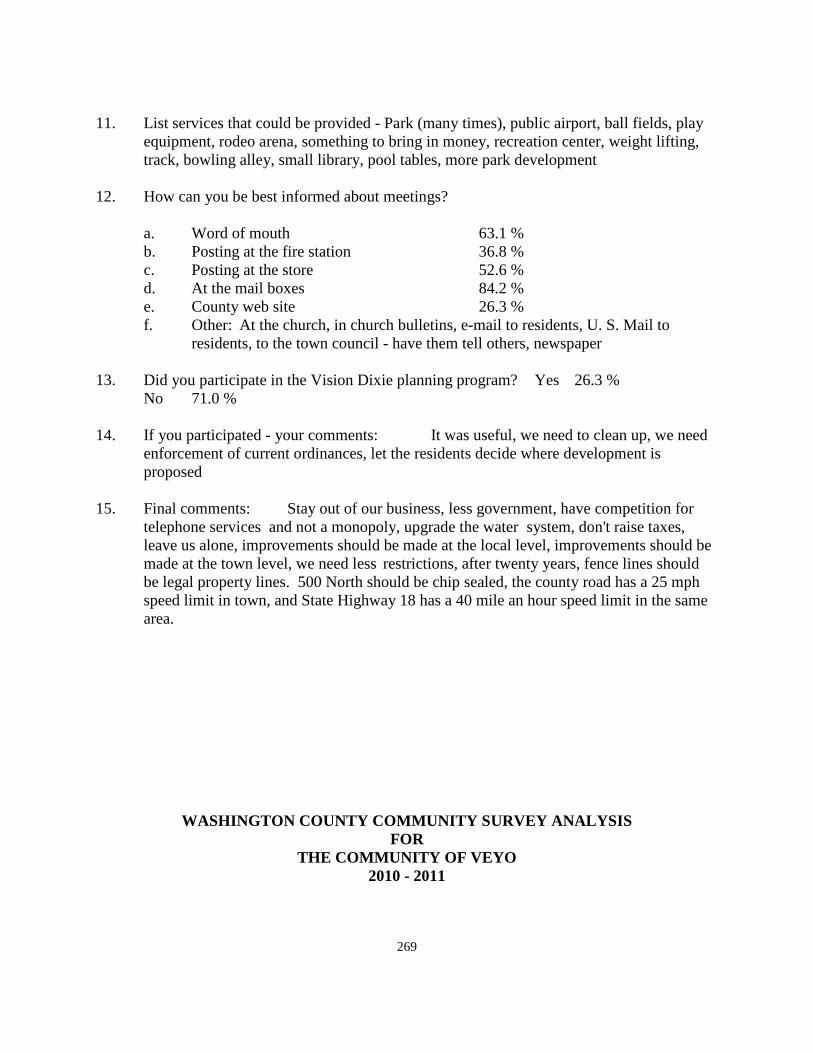
269
11. List services that could be provided - Park (many times), public airport, ball fields, play
equipment, rodeo arena, something to bring in money, recreation center, weight lifting, track, bowling alley, small library, pool tables, more park development
12. How can you be best informed about meetings? a. Word of mouth 63.1 % b. Posting at the fire station 36.8 % c. Posting at the store 52.6 % d. At the mail boxes 84.2 % e. County web site 26.3 % f. Other: At the church, in church bulletins, e-mail to residents, U. S. Mail to residents, to the town council - have them tell others, newspaper 13. Did you participate in the Vision Dixie planning program? Yes 26.3 % No 71.0 % 14. If you participated - your comments: It was useful, we need to clean up, we need
enforcement of current ordinances, let the residents decide where development is proposed
15. Final comments: Stay out of our business, less government, have competition for
telephone services and not a monopoly, upgrade the water system, don't raise taxes, leave us alone, improvements should be made at the local level, improvements should be made at the town level, we need less restrictions, after twenty years, fence lines should be legal property lines. 500 North should be chip sealed, the county road has a 25 mph speed limit in town, and State Highway 18 has a 40 mile an hour speed limit in the same area.
WASHINGTON COUNTY COMMUNITY SURVEY ANALYSIS FOR
THE COMMUNITY OF VEYO 2010 - 2011
270
A meeting was held at the Veyo Water District Office on August 18, 2010. Most of those who attended the meeting filled out the questionnaire that was passed out to those in attendance. The forms could also be submitted on the county web site. Following is an analysis of the forms that have been received by the county up to the present time. 1. Residency status:
There was a rather broad range of residents attending the meeting in 2010 ranging from one to 50 years. Many of those attending had lived there for a large number of years with an average residence of about 14 years.
2. Reasons for living in Veyo:
The like for open space and a quiet community were the greatest reasons given for living in Veyo. Other reasons rating high by residents included the opportunity to keep livestock animals, a safe community and the small town atmosphere were also given high ratings. Other reasons receiving votes included living close to the mountains, and being close to family, friends, or neighbors. The lowest reasons for living in Veyo came from those born and raised there, and opportunities for recreation. There were additional reasons given by residents that were not shown in the questionnaire were such things as less restrictions, a beautiful valley, a place safe for children, clean air, being able to have gardens, orchards, pastures, chickens, cows, and putting up clothes lines, though the consultant wasn't aware that they were illegal elsewhere. All of the reasons given were good reasons for calling Veyo home.
3. Should the rural atmosphere be preserved?
This question was nearly unanimous in wanting to keep the rural atmosphere and to keep the community as it is.
Some of the methods to maintain the rural character would indicate a lack of uderstanding of county policy. 1. No curb, gutter, or sidewalk - The County will not require these improvements on any of the current roadways in Veyo. The county will only require improvements if they are requested by the residents along a particular street, in which case the improvements will be paid for by those receiving the benefit of the improvement.
2. Leave the area alone - The County neither sponsor nor encourages any specific development. Developments are proposed by land owners. No land development will be started by the county.
3. Lower taxes - Space here does not permit a basic class on tax revenue in the State of Utah. Re-evaluation is mandated by the State of Utah. The General Fund property tax rate in Washington County has not been raised in the past decade, and in fact, the levy actually goes down each year based upon the Utah State tax formula.
271
4. Let the town make its own decisions - The best way to do this is for the community to incorporate. To incorporate or not is a community decision. The county will support whatever decision the community might make at some time. 5. Require minimum sized lots - This could be done in connection with any new development that is proposed for the area. The county however does not sponsor new development, and it is not likely that currently platter parcels will be re-zoned to a lower density because existing lots are what they are. 6. Limit water connections - Veyo maintains and operates its own water company. The company could limit connections based upon availability. However, a lot owner has the same right to a water connection should they decide to build, as does a current homeowner.
7. Allow no "cookie cutter" lots - This could happen if a development is proposed for the valley. 4. Should farmland be preserved?
The response to this question was, if anything, a greater majority in favor of preserving the agriculture than to maintain the rural character. Some of the ways to do this are a repeat of those in question #3 above. Others methods suggested include the following: 1. Have no land regulations - This would not serve to preserve farm areas. They would than be developed randomly and eventually the farm area would disappear. 2. Encourage livestock - In the agricultural areas livestock are a permitted use. It is not the purpose of the county to either encourage or discourage the keeping of livestock. If livestock keeping disappears from the valley, it will be done by the live stock owners selling their animals, or no livestock owners pressuring the livestock owners to eliminate the animals. This is not a county decision under the current ordinances. 3. Let owners decide - Whether or not to keep farming is a decision that will be made by the land owner. These are protections available for owners who want to farm. These include greenbelt designations, and the creation of agricultural protection areas which the county can assist in creating. The request for either of these methods begins with the land owner desiring protection. There are also land preserves which are done privately, but which will also provide continued use of farmland if the land owner is interested in pursuing them.
5. Would you favor a system of walking/bicycle trails?
The questionnaire response reflects some disagreement among respondents. A large majority feel that they are not necessary, and that the roads and trails in the community are adequate. This is a question that could be re-visited on a community basis.
6. Concerns about various public issues.
For a majority of these issues the residents responded that there would not appear to be a significant concern. The only issue receiving a high number or responses related to the unsafe use of OHV's in the community. The solution to this concern would appear to be
272
a local education program to bring the problem to the attention of the residents who can best control the problem with their family members.
7. The question of commercial or industrial business also brought a divergence of opinion.
Many said not to additional commercial use while others identified a desire for a variety of commercial businesses in the community. Whether any of these businesses would want to come to Veyo, depends upon the economic benefits to a developer as to whether or not they are feasible. If commercial development is proposed, the county would not likely oppose approving the business based on the community response.
8. Where should commercial be located? There is not a lot of vacant land in the existing community center. Any site would need to be acceptable to the residents. 9. Experience with local public services.
Most of these services currently have a good service rating. All of the services should continue to make improvements to make their service better. None of the public services listed were given low ratings.
10. Should the community provide recreation services?
Most respondents said No. However a few listed things that they felt would be desirable. Keep in mind that there is a significant amount of park area in the community at this time. All it requires is someone to promote the development of some of the facilities that were suggested, or other facilities that would benefit the community.
11. Facilities that could be provided. See comments in #10 above. 12. How to best be informed about meetings.
Posting at the mail boxes and word of mouth were the highest recommended methods. Residents need to become more used to using the county web site for staying informed. Mail is not an acceptable method because of the cost associated with mailing notices to all county residents.
13. Did you participate with the Vision Dixie planning program?
Most indicated that they did not, but a few residents indicated that they did participate. Of the "Westside" unincorporated communities, Veyo is the only one where citizens participated in the planning program. It is the residents of the community, or those acquiring land in the community, who make decisions as to what they want to do with their land. If left in the hands of the county, no changes will be made.
273
14. If you participated - your comments. See #13 above for comments. 15. Other comments.
1. To have the county "stay out of our business", and have less county government, implies that the community should seriously consider incorporation. 2. To have competition for telephone services in beyond the authority of county government. 3. The water system is not a county water system. The county has no authority to tell the water company that improvements are necessary. 4. Survey of existing property lines is an issue of the State rather than the county. Disputes between property owners relative to property lines are a civil matter to which the county is not a participant. 5. 500 North was originally approved as an unpaved road. If the property owners along this street would like to have it paved, the county could help facilitate doing so, but the county will continue to maintain county roads in the manner in which they were originally dedicated., 6. The road running west out of Veyo is a county road. The road running north and south through town is a State Highway. Any change in that speed limit on State Highway 18 would be a decision by the Utah State Department of Transportation.
274
WINCHESTER HILLS COMMUNITY GENERAL PLAN
2010 - 2011
Introduction: Winchester Hills is an unincorporated part of Washington County. Residents and others should take time to review Section I of the county General Plan which discusses planning in general, the basis for planning, and the purpose of planning. Many of the things mentioned in the beginning of Section VII are relevant to residents of this part of the county. The Winchester Hills General Plan provides guidelines for the future for this particular part of the county in addition to those things that are applied county wide in the other sections of the General Plan. The Winchester Hills Development is one of the more recent community developments in Washington County. The first phase of 9 phases was recorded on April 7, 1980. The community celebrated its 30th anniversary in April, 2010. It was originally started by a group of partners including, Russ Walter, Pete Tolman, DeMar, and JEL. It was developed in phases over a period of several years. At the time the project was developed, Washington County did not require paved roadways. The developers determined to pave the roads in their development as an incentive to purchasers, which proved to be true. Unfortunately the county did not require curb and gutter either at that point of time. The only real drawback to the paved roads was that curb and gutter, along with the paved streets, would have eliminated many of the flooding problems that have existed since the development began. Overall, however, it has been a very desirable development. The development consisted of 9 different phases and 347 lots of approximately one acre in size. In addition some larger lots have been divided into two lots creating a total of somewhat in excess of 366 lots in the development. Geology and Geography: Winchester Hills is located in the south/central portion of Washington County. The main access to Winchester Hills is from two exits on State Highway 18 between St. George and Enterprise. The community is located about six miles north of the center of the City of St. George and is bounded by St. George on the South, Bureau of Land Management land on the East, Institutional Trust Land on the North, and Snow Canyon State Park and additional private land in the City of St. George on the West. The soil in Winchester Hills is essentially a blow sand layer situated above the Navajo Sandstone aquifer from which most of the culinary water in the county is produced. Most of the land to the north and north-east is steep hillside. A portion of the Institutional trust land to the north is adjacent to Highway 18, and extends eastward on the steep bluff area. In terms of community expansion, there is probably some of the trust land that could be developed adjacent to the
275
community. Otherwise, Winchester Hills is very near "build out" as far as future growth is concerned. Population and growth: In considering future build-out, the 366 lots in the community currently contain dwelling units on one acre lots. Based on an average family size in Washington County of about 3.2 persons per household, and lacking actual census data at this point, the General Plan would estimate the current population of Winchester Hills to be approximately 1,022 residents. The current 34 vacant lots could account for, based on the same estimated family size, an additional 108 residents for a total number of residents approximating 1,312. Assuming that the buildable portion of the Institutional Trust Land parcel north of Winchester Hills should develop along the same pattern as the rest of the community, it could be possible to add some 100 lots and 300 plus additional residents to the community. The State Trust Lands could add another 300 or more residents giving the community perhaps as many as 1,600 or more residents. Land Use: There are essentially two categories of land use in Winchester Hills. One of these is low density residential development which includes the subdivision areas in which lots were subdivided into 1 acre lots. The other land use category is open space which includes the steeper hillside areas which are undeveloped, as well as the trust land areas, a part of which could be developed. The subdivision was developed with lots large enough to allow the keeping of livestock, and is presently zoned for animal use. In its early stages of development, a race track was proposed as a part of the development, but was never constructed. Open Space The land to the east and north of the Winchester Hills subdivision is owned by the State Institutional and Trust Lands organization. Much of the land is too steep to permit a significant amount of development. One goal of the Winchester Hills community is to retain the steep hillside areas in an open space land use category. The policy of the community is to oppose development on the BLM land adjacent to the community. One of the goals of the Vision Dixie project is to "guard our signature landscapes," and to "provide rich, connected natural recreation and open space," which to residents of Winchester Hills, includes much of the State lands east and north of the community. There is some of Trust Land in the south-east corner of the Winchester Hills subdivision that is flat enough that lots could be developed. However, there is no access to this land from the subdivision. The only access would be from the land that has been incorporated into the City of St. George. Development of this land could come through annexation to that city.
276
There is another similar pocket of State Trust Land in the north-east corner of the subdivision that could be developed similar to the parcel in the south-east corner of the subdivision. Again, access to this parcel would be difficult except by accessing this land from the same access point in St. George City as would be needed for the land in the south-east corner of the area. Much of the other State land lying north of the Winchester Hills subdivision would appear to be too steep for good development, the same as the Trust Land lying east of the subdivision. There is additional State Institutional and Trust Land lying parallel to State Highway 18 and running north of the Winchester Hills subdivision. This parcel is several thousand feet in length and varies in width from about 500 feet to perhaps as wide as 1,500 feet. This parcel of land could support development before the hillside becomes too steep, after which it should be preserved in its present condition in order to meet the Vision Dixie recommendation to protect steep hillside areas and view areas. The General Plan would submit that the parcel is generally too narrow to support significant residential development. Its location parallel to the Highway further negates the desirability for residential development. Because it appears as a narrow strip of land along the State Highway, it could possibly support some type of commercial development. However the General Plan has never supported a strip commercial development along any major highway. There would appear to be no reason why commercial development would be successful in this location between Winchester Hills and Diamond Valley. However, the original developers of Winchester Hills still retain water rights in the water company and storage rights in the Winchester Hills water storage tank. Perhaps the alternative is: 1. Would it be preferable to support development on the State Trust Land property where there could likely be some 100 lots added to the community, and over which the community would have some voice in the type and character of development, or; 2. Let it annex to the City of St. Gorge, over which the Winchester Hills community would have no voice in its development. In this case the water that is currently owned would most likely be deeded to the City of St. George, giving them some ownership of the Winchester Hills Water Company. These constitute decisions that the community of Winchester Hills will some time have to face and deal with. The BLM land adjacent to the State Trust Land is not likely to contain development and could reasonably be expected to remain as open space. Agricultural Land Other than the keeping of livestock animals in Winchester Hills, there is no other significant agricultural development on the one acre lots in the subdivision. Not all lot owners maintain livestock on their property. However, one goal of the community is to maintain the right to have and to maintain agricultural uses on the lots in the community. Obviously, the best way to allow
277
this use to continue is to maintain the current zoning on the property which will preserve this right. Residential Development The residential character of land in Winchester Hills is what it is. The development of this subdivision was conceived as a low density development of essentially one acre lots to allow residents to enjoy the open space feeling of the area and to allow, if desired, the keeping of a limited number of livestock animals on their property. Because the subdivision is literally at build-out with only 34 vacant lots remaining at the present time. There are no large areas of undeveloped land that could support any other type of development except for the State Trust land discussed above. The Vision Dixie process suggested as one of the development principles, that there be areas with a "broad range of housing types to meet the needs of all income levels, family types, and stages of life." Under normal conditions, and in the development of a "new" community of significant size, this principle should be considered. Unfortunately, Winchester Hills does not fit this pattern. It is currently at build out, no provision for this Dixie Principle was employed in the original concept, and at this time, it simply does not fit. The low and moderate income housing plan of Washington County is included as a county wide plan in Section VII of the General Plan. Another problem with the vision Dixie Principle listed above, in Winchester Hills is the waste disposal problem, which this plan discusses in a later section, could not have been accommodated in the Winchester Hills community development. The residential goal in this community is to continue the character of development that was put in place by the original developers. In order to accomplish this goal, the following policies could be useful: 1. Maintain the current zoning in the subdivision. 2. Retain the open space character of existing and surrounding properties. Even though the Vision Dixie project recommended developing a walk-able commercial or mixed use community center within 3/4 mile of all homes, it would not be possible in Winchester Hills unless there was a group of vacant lots near the center of the project that could be converted to commercial development. In fact, about the only possible commercial land in the area of Winchester Hills would be on the trust lands to the north of the community. Strip commercial development on the trust land adjacent to Highway 18 would not be beneficial to the community or to the traveling public. Population and growth: In considering future build-out, the 366 lots in the community currently contain dwelling units on one acre lots. Based on an average family size in Washington County of about 3.2 persons per household, and lacking actual census data at this point, the General Plan would estimate the current population of Winchester Hills to be approximately 1,022 residents. The current 34 vacant lots could account for, based on the same estimated family size, an additional 108
278
residents for a total number of residents approximating 1,312. Assuming that the buildable portion of the Institutional Trust Land parcel north of Winchester Hills should develop along the same pattern as the rest of the community, it could be possible to add some 100 lots and 300 plus additional residents to the community. The State Trust Lands could add another 300 or more residents giving the community perhaps as many as 1,600 or more residents Commercial Development There is no commercial development in Winchester Hills. In fact, aside for a few vacant lots in the area, there are no parcels of property where commercial development could take place. Winchester Hills is essentially a "built-out" community. The comments from the residents indicate that no commercial development is desired here. Originally, the developers set aside land on the west side of Highway 18 for commercial use. That land was annexed to St. George City. Whether of not it ever becomes commercial in nature is out of the hands of the residents of this community and the county. Once the ledges development to the south, located in St. George City develops, there could be commercial development as a part of that development plan. Commercial development in the Ledges would not meet the Vision Dixie recommendation for Winchester Hills, but would probably be as near, or nearer, than most Winchester residents would desire. There are a few home occupations in Winchester Hills that could be classified as somewhat commercial in nature. These are cottage industries where most of the business is conducted over the internet or else somewhere away from the community. These types of businesses will likely continue. They do not involve employees working on the site, and they require little customer parking, they do not advertise on site, and do not change the residential character of the neighborhood. Industrial Development The residents of this community are not opposed to more manufacturing or industrial development in Washington County, just not in, nor adjacent to Winchester Hills. With only about 34 vacant lots in the subdivision, there is not a parcel of land in the area that could support industrial development. Vision Dixie Principle summary 1. Plan regionally; implement locally - This General Plan for Winchester Hills is a local
plan and part of the County General Plan. 2. Maintain Air and Water quality, and conserve water - air and water quality in Winchester
Hills is very good. In conserving water, it is noted that most of the lots in the development, except for a little landscaping immediately adjacent to a home, and some livestock facilities, the balance of each lot is covered with native growth, which requires no additional outside watering. Conservation of water is very high in Winchester Hills.
279
3. Guard our signature landscapes - covered in the discussion of open space areas. 4. Provide rich, connected natural recreation and open space - also covered in the discussion
of open space, which surrounds the community. 5. Build a balanced transportation system - really does not apply to this community by
itself. The county has developed a county-wide transportation plan that includes the dedicated roadways in Winchester Hills as well as other necessary roads throughout the county. Refer to Section III of the General Plan to review the overall transportation plan for the county.
6. Get centered by focusing on growth on walk-able, mixed-use centers - Mixed use centers
cannot apply to Winchester Hills, the community is generally quite walk-able as it is. 7. Direct growth inward - this was a stand alone subdivision. It has virtually reached build
out at the present time. There are no plans for additional development outside the current subdivision.
8. Provide a broad range of housing types - has been discussed in relation to the residential
section of the plan. 9. Reserve areas for industry - discussed in the section dealing with industrial development. 10. Deals with public land conversion - none is proposed nor needed for the build-out of
future growth of the community. As an existing community prior to the Vision Dixie Plan, the community has met as
many of the planning principles as it is possible to meet under the current situation. Public Services: The public services in the unincorporated areas of the county are discussed at the beginning of Section VII of the General Plan, dealing with public services throughout the entire unincorporated area of the county. There are some of the services that should be mentioned specifically in most of the communities, including Winchester Hills. These are discussed as follows: Water: The water company in this community is a mutual water company. That means that each property owner is also the owner of a share in the water company. As part of the original development, a large storage tank was constructed on the hill above the community. It has sufficient capacity to supply the subdivision if there was a home on each and every lot in the community.
280
Should it become necessary to acquire supplementary water, it is proposed by the General Plan that the Water Conservancy District run a water line up Highway 18 to serve areas north of Winchester Hills, in which case Winchester Hills could arrange to acquire water from the District during any period when the present system was down for repairs. Liquid Waste: Winchester Hills is served through the use of septic tanks. Septic tanks, if properly maintained, can be a successful means of sewage disposal. The General Plan supports the recommendation of the State Department of Environmental Quality which recommends that septic tanks should be checked on an annual basis, and pumped whenever necessary. The largest concern in Winchester Hills is the fact that the community sits on a blow sand base located over the top of the Navajo Sandstone formation. This is the formation from which most of out culinary water is produced that serves the county. Geologists have plotted the direction of the flow of water under Winchester Hills. It generally flows in a southeastern direction. This means that if pollution should show up in the underground water supply, it may first become noticeable southeast of this area, somewhere in the vicinity of the City of Washington. There are a number of wells above the city, as well as additional wells belonging to the City of St. George. According to geologists, these sources would be the most likely to show initial contamination from the Winchester Hills area. In July of 2000, a waste water study was completed for most of the unincorporated subdivisions in the county. In Winchester Hills, the study was based upon 311 total building lots which have been exceeded by over 50 lots at the present time. If any more lots were proposed to be subdivided using septic tanks for waste disposal, it would likely require that they would be served by an on-site waste disposal system in order to gain approval for development. This could include any of the State and Institutional Trust Land that might be proposed for development unless the soils condition on the Trust Lands along the foot hills, proved to be different than that found on the valley floor. Electricity Electrical service is provided to Winchester Hills from the Rocky Mountain Power Co. Citizen comments indicate that there is a degree of dissatisfaction with the electrical needs of the community. The General Plan recommends Rocky Mountain Power evaluate its service to the community and plan for whatever corrections or additions need to be made. The use of cellular phone is another area in which citizen dissatisfaction was evidenced through the citizen comments that were given to the county. The General Plan recommends that the cellular providers look at the Winchester Hills area in terms of providing the highest quality service possible to this area. If additional facilities are needed to be constructed, companies should work through the county to achieve a higher degree of service. The General Plan would support an additional cellular tower in the Winchester Hills or the Ledges area which location is currently under discussion by the developers of that project.
281
Other services provided in the community received high ratings through citizen comments. These services include ambulance and emergency medical services, fire protection, garbage collection, law enforcement, postal service, and school transportation. Roadways are generally satisfactory on the existing local road system. The OHV use of the roads in Winchester Hills has not caused significant local problems that cannot be resolved locally. There is not an influx of people from outside the community that come there to ride their OHV's as there is in some other communities in the counties where the use of OHV's by "outsiders" creates a significant problem. Recreation facilities in Winchester Hills are minimal at the present time. There does not appear to be any great desire for the development of parks and recreation areas, walking trails, or specific bicycle routes outside of the present roadway system. One reason for these feelings is because of the open space character of the community and the accessibility of open space recreation opportunities adjacent to the community on the public lands. One of the areas of citizen concern involves the ability of the county to notify citizens of county activities and programs, particularly meetings, involving residents of the community. Currently, the most useful method is by word of mouth from one resident to another. Several other methods have been recommended which include the following: 1. Posting on the county website, or county submitting of advertising to individual computer E-mail systems. 2. Posting at the mail boxes 3. Posting with large lettering at the entrances to the community. 4. Newer posting suggestions for posting methods include such things as through cellular
advances such as facebook, twitter, and any other newer communication methods. Annexation / Incorporation Winchester Hills was given the opportunity to annex to St. George City a number of years ago when the ledges property became part of St. George. At that time the citizens determined to remain as a part of the unincorporated area of the county even though the St. George City annexations abutted Winchester Hills on the south and west sides. If annexation should become desirable in the future, annexation to St. George City is still an option. In addition, should the community of Diamond Valley incorporate, Winchester Hills could consider becoming part of a new Diamond Valley city. Two other options are also available and will continue to be options. One is to remain unincorporated in the same situation as presently exists. The other option in this case would be for Winchester Hills to incorporate itself into its own city or town. There are other incorporated towns in the county that are about the same size or smaller than Winchester Hills would be. There are also other cities in the county that are essentially land locked including such cities as Ivins, Santa Clara, and the town of Springdale and Hildale in the eastern part of the county.
282
The decision as whether to follow any of the above options, with the exception of remaining as an unincorporated community, requires action on the part of the residents of Winchester Hills. No one, except those living here and owning the property here, can affect any of the possible options. They are totally local options for the residents of the area to consider. They are identified as a part of the General Plan for the purpose of making citizens aware of what possibilities exist, without making any specific recommendation on the part of the General Plan. Winchester Hills, as it currently exists, is welcome to continue to remain unincorporated. This may be the most comfortable option inasmuch as the strengths and weaknesses of being part of the county are known factors, and are least likely to cause change in the community. The county is in the position of supporting any other option that the area may want to consider now, or at any time in the future. Winchester Hills turned down the opportunity to annex to St. George City a number of years ago, and determined to remain as a part of the unincorporated area of the county. Since that time, the city has annexed land immediately south and west of this area. Should annexation become desirable at a future time, the only obvious choice would be to become a part of the City of St. George. If Diamond Valley to the north incorporated, that could also be an option as would incorporation as a "stand alone" town. Any decision as to whether or not Winchester Hills should or should not annex to another entity, to incorporate, or to remain unincorporated, is a local decision to be made by the residents of the community.
WASHINGTON COUNTY - COMMUNITY SURVEY 2010 / 2011
1. Residency status
a. How many years have you lived in this location? 15 yrs. average. b. Number in your family 4 average. c. Home owner 100% yes Yes
d. Land owner only (no home) 1ot - also homeowner on adjacent lot 1. Approximate number of acres owned 1 ac. average. 2. Percent acres currently farmed 1.25 ac.- one owner
3. Percent open space, vacant, or grazed .5 ac. 2. Please mark characteristics that you value the most or that help you choose to live or own
property in this area 12.5 % Born or raised in the area - family roots 33.3 % Close to family, friends, or neighbors 75,0 % Close to the mountains, National Forest, and the National Park 87.5 % Like the open space 75.0 % The opportunity to have animals - horses, etc.
87.5 % Quiet community
283
62.5 % Recreational opportunities 75.0 % Safe environment 75.0 % Small town atmosphere __Others low light pollution 3. Should the rural character of the community be preserved? 87.5 % Yes
If Yes, How do you propose to do this? _Keep horses, keep lot size as it is, Minimize government involvement, Keep the city out.___________
4. Should any existing farm land be preserved? 75 % Yes If yes, how should it be done? _Allow it to continue_____________________ _______________________________________________________________ _______________________________________________________________ 5 Would you favor developing a system of walking / bicycle trails throughout the
community? 42.8 % Yes or No 57.1 % 4. Please rank (on a scale of 1 - 5, your concerns on each of the following: traffic, safety,
street and road issues. Most concerned = 5, Least concerned = 1, No problem = 0
a. Off-Highway vehicles on streets and roads 0 = 50%, 2 = 25 %, 4 = 12.5 %, 5 = 12.5%
b. Speeding vehicles / traffic control O = 50%, 2 = 25%, 4 = 12.5%, 5 = 12.5% c. Road and street condition 0 = 12.5 %, 2 = 12.5%, 3 = 12.5%, 4 = 50%, 5 =
12.5% d. Unlawful/unsafe behavior by OHV riders 0 = 50%, 2 = 12.5%, 3 = 12.5%, 5 =
12.5% e. Dedication of presently undedicated roads 1 = 37.5%, 2 = 25%, 3 = 25%, 5 =
12.5% f. Other Issues
7. List commercial businesses, or industrial/manufacturing businesses, if any, that you think
are needed, or desirable, to serve the residents and visitors to this community.
a. None = 100 % (This is not saying there should be no industrial development in the county, just none in the Winchester Hills area)
b. ____________________________________________________________ c. ____________________________________________________________ d. ____________________________________________________________ e. ____________________________________________________________ f. ____________________________________________________________
8. Where should businesses or industries identified above be located? In St. George or
Veyo. On existing commercial land, not in Winchester Hills.
284
9. Please rate on a scale of 1 to five your perception or experience with the following local
services as they relate to the area. Excellent = 5, Poor = 1, No Experience = 0
a. 3 = 28.5 %.4 = 38.5 %, 5 = 42.8% Ambulance/emergency medical b. 4 = 42.8%, 5 = 57.1% Drinking water service and quality c. 1 = 28.1%, 2 = 14.2%, 3 = 57.1% Electrical power service d. 4 = 71.4 %, 5 = 28.5 % Fire protection
e. 3 = 14.4%, 4 = 14.2%. 5 = 71.4% Garbage collection f. 2 = 28.5%, 3 = 28.5%, 3 = 42.8% Law enforcement g. 3 = 28.5%, 4 = 28.5%. 5 = 42.8% Postal Service h. 3 = 50%, 5 = 50% School transportation i. 3 = 14.2%, 4 = 28.5%, 5 = 57.1% Telephone service j. 1 = 42.8 %, 2 = 14.4%, 3 = 28.5%, 4 = 14.2% Cell phone service k. Other - list -
10. Should the community consider providing recreation facilities/opportunities for residents
of this area? 28.5 % Yes or No 71.4 % 11. If the answer to #10 was yes, list up to three community facilities that you think are
desirable?
a. Existing park bathrooms, add a park, add trails b. c
12. How can you best be informed about meetings, times, agendas, events, issues, etc.
affecting the community? Check all that may apply.
a. 33.3 % Word of mouth - neighbors and friends b. 11.1 % Notices posted at fire station
c. Notices posted at a store, if existing d. 44.4 % Notices posted at mail boxes e. 11.1 %___Posting on the Internet f. Other - List
13. Did you participate in the recent Vision Dixie planning program? _16.6%_Yes/No 83.3% 14. If you did participate, what two or three things did you find valuable about the study, or
about things that the community should do to comply with the study? They listened to the public, it was good that they were trying to involve the people.
____________________________________________________________
285
15. Any final comments relative to concerns that you would like to have considered in the General Plan study? a connection from Highway 18 to I-15 would be good, do not annex to St. George, no commercial in Winchester Hills, do not change our way of life.
__________________________________________________________________ 16. Name of community: Thank you for your participation! Results of this questionnaire will be provided at a future community meeting.
WASHINGTON COUNTY COMMUNITY SURVEY
FOR THE COMMUNITY OF WINCHESTER HILLS
2010-2011
On August 3, 2010, staff members of the county planning department met with citizens of the community of Winchester Hills at the fire station. The group was rather small, but those present entered into a healthy discussion of the Winchester Hills community. Following is a summary of the questions and comments that were responded to by those present. The length of time that the community members had lived in the community ranged from a low of 3 years to a high of 18 years, providing a good cross-section of the community. The size of family ranged from 3 up to 8. The average family size was about 4, which is a little higher than the average for the county as a whole. All of the residents were home owners with at least 1 owner having an additional vacant lot adjacent to their home. The agricultural use of land was negligible inasmuch as lot sizes are, for the most part, 1 acre lots. What small amount that might exist should be maintained. A large number of reasons were given for living in Winchester Hills. These included such things as being born or raised in the area, close to family, friends, or neighbors, close to the mountains and the forest, and State or National Parks, because of the open space feeling in the community, recreational opportunities, the ability to have livestock animals, particularly horses, a quiet community life, a safe environment (in spite of mountain lions being seen), the small town atmosphere, and a dark night sky.
286
All respondents to the questionnaire agreed that the rural character of the community should be preserved. Some ways to do this included, the continued keeping of livestock, maintain the lot sizes, remain unincorporated. A few of the respondents were in favor of developing a trail system in the area; the majority was not in favor of a trail system. Relative to roadways, most respondents se quite satisfied with the existing condition and maintenance of roads, Most have no serious concern relative to the use of off highway vehicle riders in Winchester Hills. While more industrial or commercial business may be good in Washington County, none should be located in the Winchester Hills area. St. George and Veyo were suggested areas for such development. Public Services getting high ratings in the community in terms of satisfaction of service include Ambulance service, drinking water service and quality, fire protection, garbage collection, law enforcement, the postal service, school transportation and telephone service. Less than high rankings went to electrical service, and cell phone service. Relative to local recreation facilities, residents were mostly satisfied with existing facilities. Most respondents did not participate in the Vision Dixie program. One comment however indicated that it was good that they attempted to involve the public in the Vision Dixie project. Being made aware of things going on in Winchester Hills is important to all participants in the questionnaire form. Solutions to this problem receiving the most support include word of mouth, notice posted at mail boxes, plus a bulletin board at both entrances to the community posted at the entrances with large print posters. One resident offered to make the bulletin boards available. A few citizen comments not specifically related to the questions asked:
• A connection between Hwy. 18 and I-15 in this area would be nice. • No commercial development • No industrial development • Bathrooms in the current park would be nice • Maintain home occupations • No more wilderness • Keep State land open • Keep the area rural • No annexation • Not happy with the federal policy on fires and grazing
287
����MMaappss::
Washington County General Plan Arterial and Collector Roads Motorized Off Road Vehicle Roads
Special Use Roads Non-Motorized Trails Wild and Scenic Rivers *Current and Future Utility Routes Community Plans: Brookside / Pine Valley Mountain Farms Central / Dixie Deer
Cliffdwellers /Grassy Meadows Sky Ranch Dammeron Valley Diamond Valley East Enterprise Gunlock Harmony Valley Kolob Mountain Pine Valley Pintura / 1-15 Freeway Corridor Veyo Winchester Hills
��
288
����AAppppeennddiixx II
GENERAL ANALYSIS OF EACH WILDERNESS AREA
The lands bill enacted by the United States in March, 2009, identified fifteen separate wilderness areas within the boundaries of Washington County. One of these, the Cottonwood Canyon Forest wilderness area, is located on National Forest land. Another one, The Watchman, has been included into Zion National Park along with most of the National Park. Because not everyone has access to a list of the wilderness areas, nor a map showing the wilderness locations, this section of the General Plan is devoted to a brief identification of each area, using Bureau of Land Management criteria, where available, to introduce the Washington County wilderness areas to the public. These reviews may be accessed through this document, or through the electronic copy of the General Plan found on the Washington County Web Site under the heading “General Plan 2010.” Hopefully, this information will be helpful to those desiring to learn more about each wilderness area including size, location, size, and other information. Of the fifteen sites designated by Congress, most of them were originally recommended in one form or another by the Bureau of Land Management following a very thorough study of each area. In an effort to provide information to the public, each of these areas is reviewed in this section of the General Plan. Only in those areas not recommended by the Bureau of Land Management, is the information not fully available, and therefore is of a reduced nature. Based upon their small size, a number of the designated areas do not qualify for wilderness designation on their own, but are contiguous with other federally managed area that were recommended for wilderness designation in one form or another by the Bureau of Land Management n a very thorough study of each area. As a result of federal court action, the BLM was required to address them in its final wilderness review and, subsequent land use planning processes. By not being included within the National Park, the areas are still available for such public uses as hunting and fishing. The county does expect that each of these small areas will generally be managed in conjunction with the much larger areas now designated within the park boundaries. Each of these areas also contains a stream segment designated under the wild and scenic rivers act and would be subject to collaborative management between the BLM and the park service over the entire stream segments in accordance with the BLM’s 1999 RMP and the Park’s 2001 General Management Plan. These small areas include Beartrap Canyon, Goose Creek, LaVerkin Creek, and Taylor Creek.
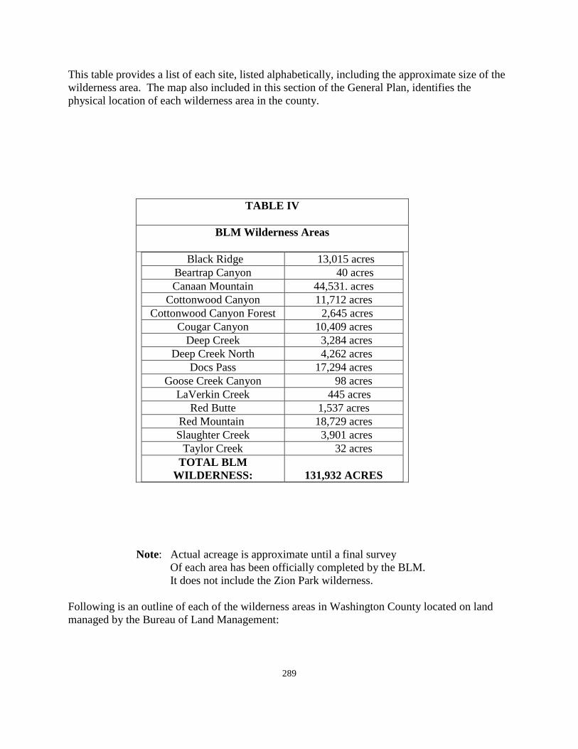
289
This table provides a list of each site, listed alphabetically, including the approximate size of the wilderness area. The map also included in this section of the General Plan, identifies the physical location of each wilderness area in the county.
TABLE IV
BLM Wilderness Areas
Black Ridge 13,015 acres Beartrap Canyon 40 acres Canaan Mountain 44,531. acres
Cottonwood Canyon 11,712 acres Cottonwood Canyon Forest 2,645 acres
Cougar Canyon 10,409 acres Deep Creek 3,284 acres
Deep Creek North 4,262 acres Docs Pass 17,294 acres
Goose Creek Canyon 98 acres LaVerkin Creek 445 acres
Red Butte 1,537 acres Red Mountain 18,729 acres Slaughter Creek 3,901 acres
Taylor Creek 32 acres TOTAL BLM
WILDERNESS:
131,932 ACRES Note: Actual acreage is approximate until a final survey Of each area has been officially completed by the BLM. It does not include the Zion Park wilderness. Following is an outline of each of the wilderness areas in Washington County located on land managed by the Bureau of Land Management:
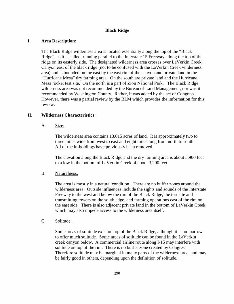
290
Black Ridge I. Area Description:
The Black Ridge wilderness area is located essentially along the top of the “Black Ridge”, as it is called, running parallel to the Interstate 15 Freeway, along the top of the ridge on its easterly side. The designated wilderness area crosses over LaVerkin Creek Canyon east of the black ridge (not to be confused with the LaVerkin Creek wilderness area) and is bounded on the east by the east rim of the canyon and private land in the “Hurricane Mesa” dry farming area. On the south are private land and the Hurricane Mesa rocket test site. On the north is a part of Zion National Park. The Black Ridge wilderness area was not recommended by the Bureau of Land Management, nor was it recommended by Washington County. Rather, it was added by the act of Congress. However, there was a partial review by the BLM which provides the information for this review.
II. Wilderness Characteristics: A. Size:
The wilderness area contains 13,015 acres of land. It is approximately two to three miles wide from west to east and eight miles long from north to south.
All of the in-holdings have previously been removed.
The elevation along the Black Ridge and the dry farming area is about 5,900 feet to a low in the bottom of LaVerkin Creek of about 3,200 feet.
B. Naturalness:
The area is mostly in a natural condition. There are no buffer zones around the wilderness area. Outside influences include the sights and sounds of the Interstate Freeway to the west and below the rim of the Black Ridge, the test site and transmitting towers on the south edge, and farming operations east of the rim on the east side. There is also adjacent private land in the bottom of LaVerkin Creek, which may also impede access to the wilderness area itself.
C. Solitude:
Some areas of solitude exist on top of the Black Ridge, although it is too narrow to offer much solitude. Some areas of solitude can be found in the LaVerkin creek canyon below. A commercial airline route along I-15 may interfere with solitude on top of the rim. There is no buffer zone created by Congress. Therefore solitude may be marginal in many parts of the wilderness area, and may be fairly good in others, depending upon the definition of solitude.
291
D. Primitive and Unconfined Recreation:
For the most part, the wilderness area would provide for primitive and unconfined recreation. It is possible, in most parts of the wilderness area, to find areas where the sights and sounds “of the world” may be mostly shut off. The area is large enough that there are pockets of true wilderness within the wilderness boundary.
E. Special Features:
This wilderness area lacks many of the special features found in other wilderness areas. Because of its connection to Zion National Park along the northern border, the area does offer some of the scenic views found within many areas of the Park.
III. Socio-Economics:
All private and some state lands have previously been graded out of this unit. No rights-of-way are known to exist in this area. The individual economic impact on Washington County from the Black Ridge wilderness area in and of itself is minimal. The mineral, sand and gravel, deposits found along the base of the Black Ridge on the freeway side of the ridge, have significant economic value to the county and make up some of the most valuable sand and gravel mineral deposits available for future county development.
IV. Manageability:
Black Ridge wilderness area can generally be effectively managed to preserve its wilderness character. Access is somewhat difficult inasmuch as the natural access through the town of Toquerville, is largely cut off by private property. A determination will need to be made by the BLM and the county as to the access into the wilderness area from the roadway along LaVerkin Creek. Some access could be made available to the east rim of the canyon through the dry farming area, most of which is private property. Limited access and areas of marginal wilderness quality will make the area easier for the BLM to manage. The Black Ridge wilderness area will likely be found near the bottom of the list of “must see” wilderness areas in Washington County. Many of the small wilderness areas offer much more in terms of wilderness qualities than does the Black Ridge.
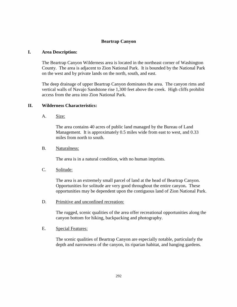
292
Beartrap Canyon
I. Area Description:
The Beartrap Canyon Wilderness area is located in the northeast corner of Washington County. The area is adjacent to Zion National Park. It is bounded by the National Park on the west and by private lands on the north, south, and east.
The deep drainage of upper Beartrap Canyon dominates the area. The canyon rims and vertical walls of Navajo Sandstone rise 1,300 feet above the creek. High cliffs prohibit access from the area into Zion National Park.
II. Wilderness Characteristics:
A. Size:
The area contains 40 acres of public land managed by the Bureau of Land Management. It is approximately 0.5 miles wide from east to west, and 0.33 miles from north to south.
B. Naturalness:
The area is in a natural condition, with no human imprints. C. Solitude:
The area is an extremely small parcel of land at the head of Beartrap Canyon. Opportunities for solitude are very good throughout the entire canyon. These opportunities may be dependent upon the contiguous land of Zion National Park.
D. Primitive and unconfined recreation:
The rugged, scenic qualities of the area offer recreational opportunities along the canyon bottom for hiking, backpacking and photography.
E. Special Features:
The scenic qualities of Beartrap Canyon are especially notable, particularly the depth and narrowness of the canyon, its riparian habitat, and hanging gardens.
293
III. Socio Economics:
There is no state of private in-holdings, sub-surface rights-of-way in the Beartrap Canyon Wilderness. The land is presently used for unconfined and primitive forms of outdoor recreation and wildlife habitat. No individual adverse economic impact on Washington County is anticipated from the designation of this area as wilderness. The only economic related activity in the wilderness area is recreation.
IV. Manageability:
Beartrap Canyon, along with all of the small wilderness areas lying north and east of Zion National Park, can be managed to preserve the wilderness characteristics that exist there. Access is very difficult and visitor use has been very limited. Because of its remote location and qualification for wilderness in connection with similar wilderness classifications for wilderness, it is not expected that the management and use of the area will change materially as a designated wilderness.
294
Canaan Mountain:
I. Area Description:
The Canaan Mountain Wilderness Area is on land managed by the Bureau of Land Management. It comprises approximately 44,531 acres as depicted in the Washington County General Plan Map.
The Canaan Mountain Wilderness Area is located in the extreme south-east corner of Washington County, running northward to a co-boundary with Zion National Park It is contiguous in part with the State of Arizona along the southern boundary, except for the incorporated town of Hildale. It is bounded on the east by Kane County and on the west by the incorporated town of Apple Valley. Some of the wilderness lies inside the town limits of Apple Valley. The wilderness area is located about 25 miles west of Kanab, in Kane County.
Canaan Mountain is a beautiful plateau that towers 2,000 feet above the surrounding lands. From the top of the plateau, a panorama of Zion National Park, the Arizona Strip, and the Pine Valley Mountains are visible. There is a variety of vegetation, including hanging gardens, ponderosa pine, Douglas fir, aspen, maple, and pinion pine.
II. Wilderness Characteristics: A. Size:
The wilderness area, as approved is 44,531 acres in size. It is about ten miles wide from east to west, and is about nine miles long from north to south.
B. Naturalness:
Canaan Mountain is the largest undisturbed plateau top or tableland remaining in southwest Utah. It possesses a quality of remoteness and naturalness not found any where else in the immediate region. It is in a natural condition with one major exception, and a few minor ones.
Past human activity includes vehicular tracks from the east side of the mesa to the cable and sawmill site on the westerly side, a house trailer, fences, and a historical cable lumber lowering operation from the top to the bottom of the plateau. These activities encompass a very small portion of the overall area.
C. Solitude: The wilderness area affords outstanding opportunity for solitude. The plateau on
Canaan Mountain is a large, rough, sandstone area that gives the visitor a feeling
295
of isolation. Slotted walls of the vermillion cliffs and talus slopes at the base of the cliffs also provide for solitude. Several deep, narrow, and thickly vegetated canyons that penetrate the plateau provide seclusion.
D. Primitive and Unconfined Recreation:
A large part of the Canaan Mountain provides outstanding opportunity for hiking, horseback riding; rock climbing, photography, bird watching, and sightseeing. Areas suitable for backpacking are the most extensive, but backpacking is somewhat limited to canyon and plateau tops because of the rugged terrain. Scenic quality is outstanding throughout the area, and is the main objective of hiking. Among the scenic features are the cliffs, large expanses of slick rock, and waterfalls during period of heavy storm, abrupt rock rims with views of Zion National Park and the Arizona Strip.
E. Special Features:
1. Scenery, similar to scenery in Zion National Park is a significant characteristic of the wilderness area. The summit of the Canaan Mountain is an essentially intact expanse, unlike the much smaller, separated plateau remnants in Zion National Park.
2. The lumbering operation that existed on the mountain from 1904 to about
1928 has important historical value, and is a significant part of the customs and culture of Washington County. Conceived by David Flanigan, he constructed a windlass and pulley system onto the westerly side of the mountain. It was used to lift men, equipment, and supplies 2,000 feet upward to the top of the mountain. As many as 25 men were employed there. By 1906, as much as 200,000 feet of timber had been lowered to the base of what was by then called Cable Mountain. The lumber was cut, and then hauled for construction purposes to settlements up the river and down the river as far away as St. George. In later years, logs up to four feet in diameter were harvested from this area, and used to make shingles from a shingle mill set up at the base of the mountain. Access to this historic site would be from an existing ORV trail crossing the mesa. This trail has been used by many groups for forty years or more years prior to the current wilderness designation. Access to this historic site is from the Kane County side of the mountain.
3. Smithsonian Butte is a special landmark land feature that is included in the
Canaan Mountain Wilderness area. The boundary of the wilderness area was enlarged in order to include this special land feature as a part of the wilderness. It has actually been annexed into the town of Apple Valley in order to provide additionally protection. Except for some animal life,
296
vegetation, and bird nesting, many of the standard features of wilderness such as size, solitude, naturalness, recreation, etc., do not exist around Smithsonian Butte. It belongs in the wilderness area because of what it is, and not because it qualifies for special protection on its own.
4. Another historic site exists in the Canaan Mountain area near the north-corner of the area known as the Mail Drop. At one point the pony express rider coming out of Kane County, rode to the edge of the Canaan Mountain ridge and dropped the mail over the edge. The mail was picked up near the town of Schunesburg, and delivered to communities all along the Virgin River. This practice of using the mail drop continued for several years. This site is also accessed from the Kane County side of Canaan Mountain.
III. Socio-Economics:
One private in-holding remains inside the designated area. No individual adverse economic impact on Washington County is anticipated from the designation of this area as wilderness.
IV. Manageability: A. The area can be effectively managed to preserve all wilderness values now
present in the wilderness area. Continued use of the range land and livestock grazing would not significantly affect wilderness management. One private in-holding remains inside the designated area.
B. The nearly 100 year old historic lumber site creates a different situation. In all of
the wilderness areas and formerly wilderness study areas, it has always been a common practice to “cherry stem” access-ways into the area in order to create wilderness. The same situation exists on Canaan Mountain. The most difficult area to maintain as wilderness in Washington County is the current trail across the plateau from the easterly to the westerly side. This type of facility is much like other timber producing activities found in areas of the county. Residents of the county and visitors to the county want to use off-road vehicles to visit the site of early resident activity. It is a part of the culture and customs of the county that should be preserved and made accessible to those desiring to visit the site. The General Plan recommends that access be provided, and is prepared to discuss methods by which is can accomplished.
297
Cottonwood Canyon
I. Area Description:
The Cottonwood Canyon wilderness area is located in south-central Washington County approximately 3 miles north of the city of Washington. The area is characterized by sharp, steep and jagged exposures of Navajo Sandstone, with elevations ranging from 3,200 feet to 4,870 feet. The area is situated near the southeastern base of the Pine Valley Mountains, which tower above it. It also borders the developed camping portion of the BLM Red Cliffs Recreation area on the east. It is bounded by the Dixie National Forest on the north and by additional BLM, State, and private land on the south and west.
II. Wilderness Characteristics: A. Size.
This wilderness area contains 11,712 acres of land managed by the Bureau of Land Management. It is approximately 7 miles wide from east to west, and three miles wide from north to south.
B. Naturalness:
For the most part, the area is in a natural condition with few noticeable human imprints, and contains a high quality of naturalness.
C Solitude:
Topographic screening makes the opportunity for solitude outstanding in this wilderness area. The screening is associated with the exposures of Navajo Sandstone. The sights and sounds of human activities are not present from most places. From the higher points of the area, traffic on I-15 can be observed. Noise from aircraft is not considered to be significant or impairing to wilderness values since few small planes per day fly over the area. Most of the heads of drainages in Mill Creek and Washington Hollow provide solitude. Other opportunities are also found in the upper Heath Wash, in the rim areas in the lower Cottonwood Canyon area, and in the cliff area south of Quail Creek.
D. Primitive and Unconfined Recreation:
The opportunity for primitive recreation is outstanding in portions of the wilderness area because the canyon hiking activity is of outstanding quality. The cottonwood heath canyon area contains superior hiking opportunities. It is more limited in the Washington hollow-mill creek complex.
298
E. Special Features:
The wilderness area is rated class A for scenic quality. The exposed Navajo sandstone cliffs provide scenic beauty. Bird watching, especially the bald eagle and peregrine falcon are seen in this area.
III. Socio-Economics:
There are still issues with existing water development that need to be resolved as a part of the BLM Management Plan. The county General Plan recommends that the BLM work closely with the county and city officials to resolve concerns that may still exist with water or land ownership. The land bill does not provide for new water development. There are no existing in-holdings in the wilderness area.
One critical economic component of concern to the county is to identify, on cooperation and coordination with the public agencies, one or more northern transportation routes across the county from east to west, as required by Congressional action. The General Plan recommends that the public agencies that may be involved, work closely with the county and the cities involved in identifying this route within the framework set out by Congress.
IV. Manageability:
The Cottonwood Canyon wilderness area would appear to create no serious management challenges. The major challenge may be to determine how best to manage the area inasmuch as it is completely inside the current desert tortoise reserve, and has been placed in a national conservation area by the action of Congress. The Section 10 permit for the HCP tortoise recovery is scheduled to expire in 2016. The General Plan recommends that this become a natural transition from the current management plan to the new management plan with the County still acting as the land coordinator in close cooperation and coordination with the various public agencies that are currently involved in its management. It is expected that the BLM, working closely with the county and the other public agencies, will work out the details of how to make this transaction come about in a natural, seamless manner.
299
Cottonwood Canyon Forest
I. Area Description: The Forest Service Cottonwood Wilderness area is immediately adjacent to the BLM Cottonwood Wilderness area near the north-east corner of the BLM wilderness area.
II. Wilderness Characteristics:
A. Size: According to the land bill, the area contains 2,643 acres, and is somewhat
“square” in size. B. Naturalness: The area is in a natural condition with a high quality of naturalness. C. Solitude:
Topographic screening makes the opportunity for solitude very high in this area. The area is composed of a series of badly fractured sandstone ravines. The county concurred that, attached to the cottonwood wilderness area, it qualified for wilderness designation. The one detraction to solitude is the overflight of commercial airlines and private air planes approaching or departing from the current St. George. This flight pattern could change with the completion of the new airport in 2011.
D. Primitive and unconfined recreation:
There is good opportunity for primitive recreation in this wilderness area because of the difficulty of access to and travel within the area.
E. Special Features:
The wilderness area is rated A for scenic quality. The exposed Navajo Sandstone cliffs provide scenic beauty. Bird watching should be excellent in this area.
III. Socio-Economics:
No individual economic impact on Washington County is anticipated from the designation of this area as wilderness.
300
IV. Manageability:
The National Forest Wilderness designation would appear to create no serious management challenges. The main challenge may be to determine how to best manage the area inasmuch as it is inside the national conservation area created by Congress. The General Plan would suggest that the Forest Ranger from this part of the Dixie National Forest be given a seat along with the current management group of the Red Cliffs Desert Reserve and that the area be managed cooperatively by the current organization presently in place with the addition of a forest service representative.
301
Cougar Canyon
I. Area Description: The Cougar Canyon wilderness area is located in the northwest corner of the BLM managed land in Washington County, and adjacent to the Nevada State line. It was originally proposed as a companion area to the same quality of land on the Nevada side of the State line. The Nevada WSA was eliminated by Congress as a part of the Lincoln County, Nevada wilderness bill. The Utah portion was later designated by Congress as wilderness in March, 2009.
Cougar Canyon is characterized by hot summers and relatively short, mild winters. Cold spells are of short duration. The wilderness area is at the headwaters of the Beaver Dam Wash and is adjacent to Clover Mountain, which extends east-west from Nevada into Utah. It is adjacent to the Dixie National Forest on the North, Nevada on the west, and BLM land on the south and east. The wilderness area contains steep mountainous canyons, long ridges, and rough drainage areas:
II Wilderness Characteristics: A. Size:
The Cougar Canyon wilderness area contains 10,409 acres of public land managed by the Bureau of land Management. The area is approximately 4 miles wide by 5 miles long.
B. Naturalness:
The wilderness area is basically natural. There are a few signs of man, including several miles of range fence, and a spring development. The area meets the wilderness criteria for naturalness.
C. Solitude:
There are outstanding opportunities for solitude, particular in the canyon bottoms. The size and configuration of the wilderness area neither enhances nor detracts from the outstanding opportunities for solitude present in the recommended area. Congress specifically provided for continued use of the air space for low level training flights of military aircraft, which could conflict to some degree with the solitude of the area.
302
D. Primitive and Unconfined Recreation:
The wilderness area would allow for the continued use of livestock grazing. The fence would be allowed to remain and the existing water development could also remain. There are the activities that would be available in this wilderness area include hiking, fishing, bird watching, picnicking, and photography.
E. Special Features:
The wilderness area has several miles of perennial pools and streams that support fishing. This feature is unique to most BLM lands.
III. Socio-Economics:
Because the mineral potential of much of the western part of Washington County it has never been sufficiently explored, it is difficult to determine the possible value of minerals that could be developed in that part of the county in the future. Based upon current commercial development, there is little socio economic impact from this wilderness area, acting independently from all other areas, in the county. Some isolated private lands intrude into the northeast boundary of the area, adjacent to the forest boundary. No other private or state in-holdings exist.
IV. Manageability:
The Cougar Canyon wilderness area is manageable as wilderness. The area is rugged, relatively remote, and currently has only low to moderate recreational use. Vegetation is too sparse to provide woodland products, and mineral conflicts are unlikely. Livestock grazing in the area may continue, hunting may continue and wilderness designation will enhance wildlife habitat.
303
Deep Creek
I. Area Description;
The Deep Creek wilderness is located in northeastern Washington County. The area is adjacent to Zion National Park on the south, BLM and private on the west and north private land also on the north and on the east. The Deep Creek’s impressive canyon of Navajo Sandstone dominates much of the area, along with small portions of other deep drainage such as Kolob Creek. In places, the canyon rim rises 2,000 feet above the creek bottom. Portions of the canyon are included in the wilderness area. These regions consist of Pinion Pine, juniper, and mountain shrub woodlands, as well as Ponderosa Pine, fir, and aspen forests at the higher elevations.
II. Wilderness Characteristics: A. Size
The wilderness area contains 3,284 acres of public land managed by the Bureau of Land Management. It is approximately 2 miles wide from east to west and 3 miles long from north to south. The small size of this area, and the fact that access to the canyons is generally from non-BLM lands, primarily private lands and the National Park Service land, is a handicap to its proper management. There are however, other qualities that helped qualify Deep Creek as a wilderness area.
B. Naturalness:
The area is in a natural condition, with little human imprint in the canyons below the rim.
C. Solitude:
The deep Creek wilderness area provides opportunities for solitude due to the deep, rugged, and winding canyon terrain, the side drainage, vegetative screening, and isolation of the area. However, the small size of the wilderness area limits its composition to segments of several canyons, with the longest segment consisting of approximately 4 miles of Deep Creek Canyon. Outstanding solitude opportunities are dependent upon the longer lengths of the canyons and the canyon rims which involve other contiguous lands, particularly lands within Zion National Park.
D. Primitive and Unconfined Recreation:
304
The rugged and highly scenic qualities of the Deep Creek Wilderness area offer recreational opportunities along the canyon bottom for hiking, sightseeing, backpacking, photography, and fishing. When combined with adjacent public lands, recreational opportunities are considered to be outstanding.
E. Special Features:
The scenic qualities of the Deep Creek area are quite spectacular. Because these tributary canyons lead directly into Zion National Park, they are not far upstream from their confluences with the Zion narrows. The Deep Creek and Deep Creek North wilderness areas contain some of the only designated segments of wild and scenic rivers currently designated in the State of Utah on BLM lands.
III. Socio-Economics:
Individually, Deep Creek holds no significant economic benefit to the County other than for recreation. There is no state or private in-holdings within the wilderness area. There is a motorized ATV trail bisecting Deep Creek and Deep Creek North. The trail is extremely steep and allows legal access between the private properties on the east and west sides.
IV. Manageability:
Overall, the area could be managed to preserve its wilderness character. Administration of the area may be difficult because of the limited areas of access across private land. Visitor use can be monitored and controlled through a cooperative effort by the BLM and the National Park Service. The BLM may acquire some private land access points to the west side of the wilderness area to precipitate access into the canyons.
305
Deep Creek North I. Area Description:
Deep Creek North is separated from the Deep Creek wilderness area by an east-west motorized trail running between the two wilderness areas. The deep creek north area was not recommended by the BLM for wilderness consideration. Both areas were evaluated, but only the southern part was recommended.
The Deep Creek North wilderness area contains 4,062 acres, which is actually larger than the Deep Creek wilderness area. The major difference between the two wilderness areas is found in the imprint of man. The east-west motorized trail and other adjacent roadways are more noticeable in Deep Creek North. There is a problem with State and private land being located within the boundary of the north wilderness area that will need to be resolved by the BLM, including possible land trades to benefit all affected entities.
Access into Deep Creek North is more difficult because it is essentially surrounded by private land ownership which may or may not allow access into the canyons, which is where the naturalness, solitude, and unconfined recreation is mostly located.
Beyond the above considerations, there is no reason to duplicate the Deep Creek evaluation for Deep Creek North. To a greater, or lesser, degree the comments relative to one of the wilderness areas applies to the other one. To get a feel for Deep Creek North, read the summary of conditions found in Deep Creek. They are both not unlike each other with Deep Creek North being to a lesser degree even though it contains more acreage. The qualities that set these areas apart as wilderness areas are found in the bottoms of the deep canyons, and not above the rims.
Both areas all together account for a total of 7,346 acres of wilderness in Washington County.
II. Wilderness Characteristics: Please see description from Deep Creek wilderness area. III. Socio-Economics.
Individually, Deep Creek North holds no significant economic benefit to the county other than for recreation.

306
IV. Manageability
The management of the Deep Creek North wilderness area should be no more difficult for the Bureau of Land Management at all of the other wilderness areas located in the northeast part of Washington County in the Kolob portion of Washington County. Signing, fencing, and monitoring issues increase with additional acres.
307
Doc’s Pass
I. Area Description:
Doc’s pass is located in the west part of Washington County, along the Nevada border. It is approximately 9 miles from north to south and 3 to 4 miles wide. It is bounded by the State of Nevada on west, the Beaver Dam Wash on the north and east, and BLM, private, and State land on the south.
Doc’s Pass contains 17,294 acres, making it one of the larger wilderness areas in the county. Doc’s pass was not recommended by the Bureau of Land Management for wilderness designation at any time. Therefore the more detailed consideration of Doc’s pass has not been specifically completed. However, because of its relationship to the Cougar Canyon wilderness area, there are obviously significant similarities between the two areas. Both areas, according to Congress, are subject to low level training flights from military aircraft flying in the area. Both areas do provide areas for naturalness, solitude, along with primitive and unconfined recreation.
Active mining claims remain on the west boundary of the area. Access to the claims will need to be maintained. There are many roadways traversing Doc’s pass from one end to the other which will need to be resolved by meetings between the BLM and Washington County. At least some of these roadways will need to be retained. In addition, there are state lands and private in-holdings within the wilderness boundary that will also need to be resolved by the County, BLM, and the other stakeholders involved. There have been range improvements within the wilderness area, and livestock permits are allowed to continue following wilderness designation. The Doc’s Pass wilderness area may have been designated by Congress for the purpose of placating the environmental community and adding acreage to the total land in the County, more than for actual wilderness value. However, the County, working closely with the BLM, will find ways to resolve the problems created by the wilderness designation, thereby making Doc’s Pass a valid wilderness addition to the County.
II. Wilderness Characteristics: Please see the Cougar Canyon wilderness area for similar information. III. Socio- Economics: Please see the Cougar Canyon wilderness area for similar characteristics. IV. Manageability:

308
The manageability of Doc’s Pass, coupled with the Cougar Canyon and the Slaughter Creek Wilderness area, which are all close to one another, should make the three wilderness areas along the west side of the county, more manageable because of their proximity.
309
Goose Creek Canyon I. Area Description:
The Goose Creek Canyon area is located in the northeast corner of Washington County. The area is adjacent to Zion National Park on the south and private land on the north, east, and west. This parcel is isolated from other BLM lands.
The deep drainage of Goose Creek Canyon dominates the area. The canyon rims and vertical walls of the Carmel formation and Navajo sandstone tower 2,000 feet above the creek, exposing these various rock formations. The only access into the canyon is through Zion National Park. The sheer walls at the upper end of the canyon do not permit access. The upper rim may be viewed by way of a road paralleling the north side of the wilderness area.
II. Wilderness Characteristics:
Size:
This wilderness area contains 98 acres of public land managed by the Bureau of Land Management. It is approximately 0.25 miles wide from east to west and 0.50 miles long from north to south. By itself, the wilderness area does not qualify for wilderness designation based upon size. However, combined with the National Park, it can qualify as a wilderness area.
B. Naturalness:
The canyon area is in a natural condition, with no significant imprint.
C. Solitude:
The rugged, winding canyon of Goose Creek does provide opportunity for solitude, particularly when considering the area’s difficult accessibility and isolation. Its existing opportunities for solitude are tied to the adjacent wilderness area of Zion National Park.
D. Primitive and Unconfined Recreation.
The rugged, scenic qualities of the area offer recreational opportunities for hiking, backpacking, technical rock climbing, and photography. It must be accessed through Zion National Park. Because of its location and accessibility, the number of annual visitors to the Goose Creek Canyon Wilderness is very low.
310
E. Special Features:
All of the wilderness area has significant scenic value. That segment of Goose Creek running through this parcel has been designated under the wild and scenic rivers act.
III. Socio-Economics:
No individual adverse economic impact on Washington County is anticipated from the designation of this area as wilderness. There are no state or private in-holdings, sub-surface rights in the wilderness area. The land is presently use for unconfined and primitive forms of outdoor recreation and wildlife habitat.
IV. Manageability:
Goose Creek Canyon wilderness area could be effectively managed to preserve its wilderness character. Access is very difficult but visitor use could be monitored through Zion National Park. Because of its remote location and because of its qualification for wilderness in connection with similar wilderness land inside the national park, the Goose Creek Canyon has, except for size, the necessary qualifications for wilderness. It is not expected that the management and use of the area will change materially from its present condition because of its remote location and lack of accessibility.
311
LaVerkin Creek Canyon I. Area Description:
The LaVerkin Creek Canyon wilderness area is located in the northeastern part of Washington County. The area is bordered on the south by Zion National Park; it is surrounded by private land on the other side. The area consists mainly of 1.5 miles of the LaVerkin Creek and a very small portion of the Bear Trap Canyon drainage. The canyon rims rise 700 to 900 feet above the creek.
II. Wilderness Characteristics: A. Size:
The wilderness area contains 445 acres of public land managed by the Bureau of Land Management. It is approximately 1 mile wide from east to west, and 1.25 miles long from north to south. The wilderness area is basically “L” shaped.
B. Naturalness: The area is in a natural condition, with no noticeable human imprints. C. Solitude:
In connection with the adjacent Zion National Park, the area has outstanding solitude opportunities throughout the entire area.
D. Primitive and Unconfined Recreation:
Some recreational opportunities exist along the canyon bottoms such as hiking, back packing, horseback riding, and photography. Outstanding opportunities for unconfined recreation exist when combined with the wilderness area of Zion National Park.
E. Special Features: All of the area has excellent scenic values. III. Socio-Economics:
There are no state or private in-holdings sub-surface rights in the wilderness area. No individual adverse economic impact on Washington County is anticipated from the designation of this area as wilderness.
312
IV. Manageability:
The LaVerkin Creek wilderness area could be effectively managed to preserve its wilderness character. Access to the area is very difficult, but visitor use could be monitored through Zion National Park. Because of its remote location, and because of its qualifications for wilderness in connection with similar wilderness inside the National Park, the LaVerkin Creek wilderness has, except for a lack of size, the necessary qualifications for wilderness. It is not expected that the management and use of the area will change materially from its present condition.
313
Red Butte
I. Area Description:
The Red Butte Wilderness area is located in eastern Washington County, approximately fifteen miles north of the town of Virgin. The area is adjacent to Zion National Park on the north, State trust land on the south, and private lands on the east and west sides.
The area predominantly consists of a large sandstone butte, set amidst a dense mountain scrub brush such as sage, serviceberry, Manzanita, pinion pine, ponderosa pine and juniper. Elevations of the site range from 5,500 feet to 7,400 feet, with the Red Butte wilderness rising some 1,800 feet above nearby Smith Mesa, and 1,200 feet above the lower Kolob Plateau.
II. Wilderness Characteristics: A. Size:
The wilderness area contains 1,537 acres of public land managed by the Bureau of Land Management. It is approximately 1.25 miles long from north to south, and 1.25 miles wide from east to west. By itself, the wilderness area does not quality for wilderness designation based upon size. However, combined with the National Park, it can qualify as a wilderness area
B. Naturalness:
The area is in a generally condition with a few human imprints. The wilderness area has been primarily affected by the forces of nature. A few lightly used jeep trails exist along its eastern boundary. A developed spring and surface pipeline are located just inside its western boundary.
C. Solitude:
The area does provide opportunities for solitude due to its difficult accessibility, isolation and dense vegetation. The main reason for its solitude stems from its isolation which is created by the large expanse of undeveloped land surrounding the red butte area. It is not protected from outside sounds by the land use bill enacted by Congress.
D. Primitive and Unconfined Recreation:
The area offers recreational opportunities such as deer hunting, hiking, backpacking, nature study, geologic study, and technical rock climbing. Overall,
314
outstanding opportunities for primitive and unconfined recreation are found in the Red Butte Wilderness area.
E. Special Features:
The most special feature of this area is that it is rated as outstanding for scenic quality.
III. Socio-Economics:
There are no state or private in-holdings, sub-surface rights, or rights-of-way in the Red Butte Wilderness area. The land is presently used for unconfined recreation. Very little economic change will be noticed by wilderness designation. Livestock grazing may continue, and there is little other opportunity for other economic development.
IV. Manageability:
Overall it appears that the wilderness area can be effectively managed to preserve its wilderness character. Access is difficult across private land, but could be monitored in connection with Zion National Park. It is not expected that management and use of this wilderness area will change materially from its present condition because of its remote location and lack of accessibility.
315
Red Mountain
I. Area Description:
The Red Mountain wilderness area is located on Bureau of Land Management lands in the south central part of Washington County, just north of the city of Ivins. It is approximately 8 or 9 miles northwest of St. George city. Red Mountain is a plateau of deep red Navajo Sandstone rising 1,400 feet above the city of Ivins and the Santa Clara bench, to elevations of 4,600 feet to 5,432 feet.
The wilderness area borders Snow Canyon State Park on the east, nearly to the homes in the City of Ivins on the south, and Gunlock State Park on the west.
II. Wilderness Characteristics: A. Size:
The Red Mountain wilderness area contains 18,729 acres of public land. It is approximately six miles from east to west and 7 miles from north to south.
B. Naturalness:
All appears to be natural in character. In close proximity to the urban valley, Red Mountain is perceived as an island of naturalness. Imprints that existed at the time of the BLM inventory included about 5 miles of roadway, about .05 miles of fence remnants, and a livestock watering trough. Only about 5 surfaces are affected, but these imprints are substantially unnoticeable. No surface disturbing a activities other than fire suppression, restoration, and occasional ATV intrusions have occurred since the inventory.
C. Solitude:
Not all of the area has been identified as having outstanding opportunity for solitude. Outside sights and sounds from the Santa Clara Bench are readily apparent from the rim of the plateau, and below to the city of Ivins. The opportunity for solitude lies with the top of the plateau, away from the rim.
D. Primitive and Unconfined Recreation:
Outstanding opportunity for primitive recreation exists on the plateau at the top of the rim. Opportunities for hiking, backpacking, and horseback riding are rated as above average in the Red Mountain wilderness area. There is a lack of water which may limit the length of stay in the area.
316
E. Special Features:
The wilderness area is rated as outstanding for scenic quality. Much of this is related to the views from the rim of the mountain overlooking the Santa Clara Bench, Gunlock Reservoir, and Snow Canyon State Park.
III. Socio-Economics:
With all of the mining and mineral leases filed over the years in the wilderness area, this area could realistically see significant revenue loss to the county as a result of the wilderness designation by Congress. Actual development of mineral resources and mineral leases are, however, distinctly different. No significant development has taken place since the area was made into a wilderness study area. It is not likely now. There would appear to be at least one section of State land within the wilderness boundary that would need to be traded out of the area.
IV. Manageability:
The area can be managed by the BLM much as it has been for many years. The combined management of the Red Hills Desert Reserve and the new addition of the National Conservation area over the top of the wilderness area will require some management decisions in the future. The General Plan recommends coordinating with the public agencies with a proposed plan to continue the area much as it is now. The County and the public agencies will need to work together to develop the details of this management.
317
Slaughter Creek
I. Area Description:
The Slaughter Creek wilderness is located in the north-west part of Washington County, immediately adjacent to the Cougar Canyon wilderness area. It is approximately 3 miles from north to south and 2 miles wide from east to west. The Slaughter Creek wilderness area contains 3,901 acres, and was designated by Congress as a part of the Washington County wilderness bill.
As a result of congressional designation, rather than having been identified as wilderness by prior study of the Bureau of Land Management, it does not have the same information available for use that it would have had if it had been identified for wilderness by the BLM. Slaughter Creek is also adjacent to Doc’s Pass, another wilderness area created by Congress without having gone through the FLPMA process.
The characteristics of Slaughter Creek most naturally relate to the Cougar Canyon wilderness area. Therefore, by reviewing the information from Cougar Canyon, there will be many similarities between the two areas.
II. Wilderness Characteristics: Please see the Cougar Canyon wilderness area for similar information. III. Socio-Economics:
Some active mining claims remain on the south-east border of the wilderness area. Potential for further development and production is unknown. There is no other state or private in-holdings.
IV. Manageability:
The manageability of Slaughter Creek, coupled with Doc’s Pass and the Cougar Canyon wilderness area, which are all contiguous, except for roadways, should make the three wilderness areas along the west side of the county more manageable because of the benefit of proximity with one another. Combined, they create a wilderness area of 31,604 acres.
318
Taylor Creek Canyon
I. Area Description: The Taylor Creek Canyon wilderness area is located in the northeast corner of Washington
County. The area is adjacent to the Kolob Canyons of Zion National Park. It is bounded by National Park land on the east, private lands on the east and state lands on the north and south.
The area is dominated by the rugged, barren slick rock terrain found at the head of a deep drainage, the middle fork of Taylor Creek. The vast majority of this canyon is within Zion National Park. The canyon rims and sheer walls of the Carmel formation and Navajo Sandstone rise 1,000 feet above the canyon floor. Elevations range from 6,800 feet to 7,000 feet within the area. High cliffs prohibit access into the National Park.
II. Wilderness Characteristics: A. Size:
The area contains 32 acres of public land managed by the Bureau of Land Management. It is approximately 0.25 miles wide from east to west and about the same from north to south.
B. Naturalness: The area is in a natural condition, with no human imprints. C. Solitude: The area encompasses only an extremely small parcel of land at the head of Taylor Creek
Canyon. Opportunities for solitude are very good throughout the entire canyon. D. Primitive and Unconfined Recreation: The rugged, scenic qualities of the canyon offer recreational opportunities along the canyon bottom for hiking, backpacking, and photography. E. Special Features: The scenic qualities of Taylor Creek Canyon are especially notable, particularly the depth and colorful walls of the canyon. The canyon provides habitat for raptors. That portion of the Taylor Creek headwaters that runs through the wilderness area has been designated by Congress under the wild and scenic rivers act.
319
III. Socio-Economics:
By itself, there is no expected economic impact on Washington County from the designation of Taylor Creek Canyon as a wilderness area. There are no private lands within the Taylor Creek Wilderness area.
IV. Manageability:
The wilderness area can effectively be managed by the Bureau of Land Management. However, in this instance, there is no access to the wilderness area from Zion National Park. Access from private land is restricted. The area has received little use, and no major increase in on-site use is anticipated. The area is unsuitable for grazing and visitor use is limited. All of the small wilderness areas allocated in the Kolob area north and east of the National Park are two small by themselves to qualify as wilderness. They do have wilderness characteristics, in many cases greater than larger areas; it should make it easier for the BLM to manage the group than it would be if there was only an isolated wilderness designation in the area.
320
����AAppppeennddiixx IIII
Omnibus Land Bill of 2009 “Subtitle O” – Washington County, Utah (Congress passed April 2009) 11 Subtitle O—Washington County, 12 Utah 13 SEC. 1971. DEFINITIONS. 14 In this subtitle: 15 (1) BEAVER DAM WASH NATIONAL CONSERVA 16 TION AREA MAP.—The term ‘‘Beaver Dam Wash 17 National Conservation Area Map’’ means the map 18 entitled ‘‘Beaver Dam Wash National Conservation 19 Area’’ and dated December 18, 2008. 20 (2) CANAAN MOUNTAIN WILDERNESS MAP.— 21 The term ‘‘Canaan Mountain Wilderness Map’’ 22 means the map entitled ‘‘Canaan Mountain Wilder 23 ness’’ and dated June 21, 2008. 24 (3) COUNTY.—The term ‘‘County’’ means 25 Washington County, Utah. O:\FLO\FLO09081.xml [file 2 of 16] S.L.C. 1 (4) NORTHEASTERN WASHINGTON COUNTY 2 WILDERNESS MAP.—The term ‘‘Northeastern Wash 3 ington County Wilderness Map’’ means the map en 4 titled ‘‘Northeastern Washington County Wilder 5 ness’’ and dated November 12, 2008. 6 (5) NORTHWESTERN WASHINGTON COUNTY 7 WILDERNESS MAP.—The term ‘‘Northwestern Wash 8 ington County Wilderness Map’’ means the map en 9 titled ‘‘Northwestern Washington County Wilder 10 ness’’ and dated June 21, 2008. 11 (6) RED CLIFFS NATIONAL CONSERVATION 12 AREA MAP.—The term ‘‘Red Cliffs National Con
321
13 servation Area Map’’ means the map entitled ‘‘Red 14 Cliffs National Conservation Area’’ and dated No 15 vember 12, 2008. 16 (7) SECRETARY.—The term ‘‘Secretary’’ 17 means— 18 (A) with respect to land under the jurisdic 19 tion of the Secretary of Agriculture, the Sec 20 retary of Agriculture; and 21 (B) with respect to land under the jurisdic 22 tion of the Secretary of the Interior, the Sec 23 retary of the Interior. 24 (8) STATE.—The term ‘‘State’’ means the State 25 of O:\FLO\FLO09081.xml [file 2 of 16] S.L.C. 1 (9) WASHINGTON COUNTY GROWTH AND CON 2 SERVATION ACT MAP.—The term ‘‘Washington 3 County Growth and Conservation Act Map’’ means 4 the map entitled ‘‘Washington County Growth and 5 Conservation Act Map’’ and dated November 13, 6 2008. 7 SEC. 1972. WILDERNESS AREAS. 8 (a) ADDITIONS TO NATIONAL WILDERNESS PRESER 9 VATION SYSTEM.— 10 (1) ADDITIONS.—Subject to valid existing 11 rights, the following land in the State is designated 12 as wilderness and as components of the National 13 Wilderness Preservation System: 14 (A) BEARTRAP CANYON.—Certain Federal 15 land managed by the Bureau of Land Manage 16 ment, comprising approximately 40 acres, as 17 generally depicted on the Northeastern Wash 18 ington County Wilderness Map, which shall be 19 known as the ‘‘Beartrap Canyon Wilderness’’. 20 (B) BLACKRIDGE.—Certain Federal land 21 managed by the Bureau of Land Management, 22 comprising approximately 13,015 acres, as gen 23 erally depicted on the Northeastern Washington 24 County Wilderness Map, which shall be known 25 as the ‘‘Blackridge Wilderness’’.
218
O:\FLO\FLO09081.xml [file 2 of 16] S.L.C.
322
1 (C) CANAAN MOUNTAIN.—Certain Federal 2 land in the County managed by the Bureau of 3 Land Management, comprising approximately 4 44,531 acres, as generally depicted on the 5 Canaan Mountain Wilderness Map, which shall 6 be known as the ‘‘Canaan Mountain Wilder- 7 ness’’. 8 (D) COTTONWOOD CANYON.—Certain Fed- 9 eral land managed by the Bureau of Land Man- 10 agement, comprising approximately 11,712 11 acres, as generally depicted on the Red Cliffs 12 National Conservation Area Map, which shall 13 be known as the ‘‘Cottonwood Canyon Wilder 14 ness’’. 15 (E) COTTONWOOD FOREST.—Certain Fed 16 eral land managed by the Forest Service, com 17 prising approximately 2,643 acres, as generally 18 depicted on the Red Cliffs National Conserva 19 tion Area Map, which shall be known as the 20 ‘‘Cottonwood Forest Wilderness’’. 21 (F) COUGAR CANYON.—Certain Federal 22 land managed by the Bureau of Land Manage 23 ment, comprising approximately 10,409 acres, 24 as generally depicted on the Northwestern 25 Washington County Wilderness Map, which
219 O:\FLO\FLO09081.xml [file 2 of 16] S.L.C. 1 shall be known as the ‘‘Cougar Canyon Wilder 2 ness’’. 3 (G) DEEP CREEK.—Certain Federal land 4 managed by the Bureau of Land Management, 5 comprising approximately 3,284 acres, as gen 6 erally depicted on the Northeastern Washington 7 County Wilderness Map, which shall be known 8 as the ‘‘Deep Creek Wilderness’’. 9 (H) DEEP CREEK NORTH.—Certain Fed 10 eral land managed by the Bureau of Land Man 11 agement, comprising approximately 4,262 acres, 12 as generally depicted on the Northeastern 13 Washington County Wilderness Map, which 14 shall be known as the ‘‘Deep Creek North Wil
323
15 derness’’. 16 (I) DOC’S PASS.—Certain Federal land 17 managed by the Bureau of Land Management, 18 comprising approximately 17,294 acres, as gen 19 erally depicted on the Northwestern Wash 20 ington County Wilderness Map, which shall be 21 known as the ‘‘Doc’s Pass Wilderness’’. 22 (J) GOOSE CREEK.—Certain Federal land 23 managed by the Bureau of Land Management, 24 comprising approximately 98 acres, as generally 25 depicted on the Northeastern Washington
220 O:\FLO\FLO09081.xml [file 2 of 16] S.L.C. 1 County Wilderness Map, which shall be known 2 as the ‘‘Goose Creek Wilderness’’. 3 (K) LAVERKIN CREEK.—Certain Federal 4 land managed by the Bureau of Land Manage 5 ment, comprising approximately 445 acres, as 6 generally depicted on the Northeastern Wash 7 ington County Wilderness Map, which shall be 8 known as the ‘‘LaVerkin Creek Wilderness’’. 9 (L) RED BUTTE.—Certain Federal land 10 managed by the Bureau of Land Management, 11 comprising approximately 1,537 acres, as gen 12 erally depicted on the Northeastern Washington 13 County Wilderness Map, which shall be known 14 as the ‘‘Red Butte Wilderness’’. 15 (M) RED MOUNTAIN.—Certain Federal 16 land managed by the Bureau of Land Manage 17 ment, comprising approximately 18,729 acres, 18 as generally depicted on the Red Cliffs National 19 Conservation Area Map, which shall be known 20 as the ‘‘Red Mountain Wilderness’’. 21 (N) SLAUGHTER CREEK.—Certain Federal 22 land managed by the Bureau of Land Manage 23 ment, comprising approximately 3,901 acres, as 24 generally depicted on the Northwestern Wash
221 O:\FLO\FLO09081.xml [file 2 of 16] S.L.C.
324
1 ington County Wilderness Map, which shall be 2 known as the ‘‘Slaughter Creek Wilderness’’. 3 (O) TAYLOR CREEK.—Certain Federal 4 land managed by the Bureau of Land Manage 5 ment, comprising approximately 32 acres, as 6 generally depicted on the Northeastern Wash 7 ington County Wilderness Map, which shall be 8 known as the ‘‘Taylor Creek Wilderness’’. 9 (2) MAPS AND LEGAL DESCRIPTIONS.— 10 (A) IN GENERAL.—As soon as practicable 11 after the date of enactment of this Act, the Sec 12 retary shall submit to the Committee on Energy 13 and Natural Resources of the Senate and the 14 Committee on Natural Resources of the House 15 of Representatives a map and legal description 16 of each wilderness area designated by para 17 graph (1). 18 (B) FORCE AND EFFECT.—Each map and 19 legal description submitted under subparagraph 20 (A) shall have the same force and effect as if 21 included in this subtitle, except that the Sec 22 retary may correct any clerical or typographical 23 errors in the map or legal description.
222 O:\FLO\FLO09081.xml [file 2 of 16] S.L.C. 1 (C) AVAILABILITY.—Each map and legal 2 description submitted under subparagraph (A) 3 shall be available in the appropriate offices of— 4 (i) the Bureau of Land Management; 5 and 6 (ii) the Forest Service. 7 (b) ADMINISTRATION OF WILDERNESS AREAS.— 8 (1) MANAGEMENT.—Subject to valid existing 9 rights, each area designated as wilderness by sub 10 section (a)(1) shall be administered by the Secretary 11 in accordance with the Wilderness Act (16 U.S.C. 12 1131 et seq.), except that— 13 (A) any reference in the Wilderness Act to 14 the effective date of that Act shall be consid 15 ered to be a reference to the date of enactment 16 of this Act; and
325
17 (B) any reference in the Wilderness Act to 18 the Secretary of Agriculture shall be considered 19 to be a reference to the Secretary that has ju 20 risdiction over the land. 21 (2) LIVESTOCK.—The grazing of livestock in 22 each area designated as wilderness by subsection 23 (a)(1), where established before the date of enact 24 ment of this Act, shall be permitted to continue—
223 O:\FLO\FLO09081.xml [file 2 of 16] S.L.C. 1 (A) subject to such reasonable regulations, 2 policies, and practices that the Secretary con 3 siders necessary; and 4 (B) in accordance with— 5 (i) section 4(d)(4) of the Wilderness 6 Act (16 U.S.C. 1133(d)(4)); and 7 (ii) the guidelines set forth in Appen 8 dix A of the report of the Committee on 9 Interior and Insular Affairs of the House 10 of Representatives accompanying H.R. 11 2570 of the 101st Congress (H.Rep. 101– 12 405) and H.R. 5487 of the 96th Congress 13 (H. Rept. 96–617). 14 (3) WILDFIRE, INSECT, AND DISEASE MANAGE 15 MENT.—In accordance with section 4(d)(1) of the 16 Wilderness Act (16 U.S.C. 1133(d)(1)), the Sec 17 retary may take such measures in each area des 18 ignated as wilderness by subsection (a)(1) as the 19 Secretary determines to be necessary for the control 20 of fire, insects, and diseases (including, as the Sec 21 retary determines to be appropriate, the coordination 22 of those activities with a State or local agency). 23 (4) BUFFER ZONES.— 24 (A) IN GENERAL.—Nothing in this section 25 creates a protective perimeter or buffer zone
224 O:\FLO\FLO09081.xml [file 2 of 16] S.L.C. 1 around any area designated as wilderness by 2 subsection (a)(1).
326
3 (B) ACTIVITIES OUTSIDE WILDERNESS.— 4 The fact that an activity or use on land outside 5 any area designated as wilderness by subsection 6 (a)(1) can be seen or heard within the wilder 7 ness shall not preclude the activity or use out 8 side the boundary of the wilderness. 9 (5) MILITARY OVERFLIGHTS.—Nothing in this 10 section restricts or precludes— 11 (A) low-level overflights of military aircraft 12 over any area designated as wilderness by sub 13 section (a)(1), including military overflights 14 that can be seen or heard within any wilderness 15 area; 16 (B) flight testing and evaluation; or 17 (C) the designation or creation of new 18 units of special use airspace, or the establish 19 ment of military flight training routes over any 20 wilderness area. 21 (6) ACQUISITION AND INCORPORATION OF LAND 22 AND INTERESTS IN LAND.— 23 (A) ACQUISITION AUTHORITY.—In accord 24 ance with applicable laws (including regula 25 tions), the Secretary may acquire any land or
225
O:\FLO\FLO09081.xml [file 2 of 16] S.L.C. 1 interest in land within the boundaries of the 2 wilderness areas designated by subsection (a)(1) 3 by purchase from willing sellers, donation, or 4 exchange. 5 (B) INCORPORATION.—Any land or inter 6 est in land acquired by the Secretary under 7 subparagraph (A) shall be incorporated into, 8 and administered as a part of, the wilderness 9 area in which the land or interest in land is lo 10 cated. 11 (7) NATIVE AMERICAN CULTURAL AND RELI 12 GIOUS USES.—Nothing in this section diminishes— 13 (A) the rights of any Indian tribe; or 14 (B) any tribal rights regarding access to 15 Federal land for tribal activities, including spir 16 itual, cultural, and traditional food-gathering 17 activities.
327
18 (8) CLIMATOLOGICAL DATA COLLECTION.—In 19 accordance with the Wilderness Act (16 U.S.C. 1131 20 et seq.) and subject to such terms and conditions as 21 the Secretary may prescribe, the Secretary may au 22 thorize the installation and maintenance of hydro 23 logic, meteorologic, or climatological collection de 24 vices in the wilderness areas designated by sub 25 section (a)(1) if the Secretary determines that the
226 O:\FLO\FLO09081.xml [file 2 of 16] S.L.C. 1 facilities and access to the facilities are essential to 2 flood warning, flood control, or water reservoir oper 3 ation activities. 4 (9) WATER RIGHTS.— 5 (A) STATUTORY CONSTRUCTION.—Nothing 6 in this section— 7 (i) shall constitute or be construed to 8 constitute either an express or implied res 9 ervation by the United States of any water 10 or water rights with respect to the land 11 designated as wilderness by subsection 12 (a)(1); 13 (ii) shall affect any water rights in the 14 State existing on the date of enactment of 15 this Act, including any water rights held 16 by the United States; 17 (iii) shall be construed as establishing 18 a precedent with regard to any future wil 19 derness designations; 20 (iv) shall affect the interpretation of, 21 or any designation made pursuant to, any 22 other Act; or 23 (v) shall be construed as limiting, al 24 tering, modifying, or amending any of the 25 interstate compacts or equitable apportion
227 O:\FLO\FLO09081.xml [file 2 of 16] S.L.C. 1 ment decrees that apportion water among 2 and between the State and other States.
328
3 (B) STATE WATER LAW.—The Secretary 4 shall follow the procedural and substantive re 5 quirements of the law of the State in order to 6 obtain and hold any water rights not in exist 7 ence on the date of enactment of this Act with 8 respect to the wilderness areas designated by 9 subsection (a)(1). 10 (10) FISH AND WILDLIFE.— 11 (A) JURISDICTION OF STATE.—Nothing in 12 this section affects the jurisdiction of the State 13 with respect to fish and wildlife on public land 14 located in the State. 15 (B) AUTHORITY OF SECRETARY.—In fur 16 therance of the purposes and principles of the 17 Wilderness Act (16 U.S.C. 1131 et seq.), the 18 Secretary may carry out management activities 19 to maintain or restore fish and wildlife popu 20 lations (including activities to maintain and re 21 store fish and wildlife habitats to support the 22 populations) in any wilderness area designated 23 by subsection (a)(1) if the activities are— 24 (i) consistent with applicable wilder 25 ness management plans; and
228 O:\FLO\FLO09081.xml [file 2 of 16] S.L.C. 1 (ii) carried out in accordance with— 2 (I) the Wilderness Act (16 3 U.S.C. 1131 et seq.); and 4 (II) applicable guidelines and 5 policies, including applicable policies 6 described in Appendix B of House Re 7 port 101–405. 8 (11) WILDLIFE WATER DEVELOPMENT 9 PROJECTS.—Subject to paragraph (12), the Sec 10 retary may authorize structures and facilities, in 11 cluding existing structures and facilities, for wildlife 12 water development projects, including guzzlers, in 13 the wilderness areas designated by subsection (a)(1) 14 if— 15 (A) the structures and facilities will, as de 16 termined by the Secretary, enhance wilderness 17 values by promoting healthy, viable, and more
329
18 naturally distributed wildlife populations; and 19 (B) the visual impacts of the structures 20 and facilities on the wilderness areas can rea 21 sonably be minimized. 22 (12) COOPERATIVE AGREEMENT.—Not later 23 than 1 year after the date of enactment of this Act, 24 the Secretary shall enter into a cooperative agree 25 ment with the State that specifies the terms and
229 O:\FLO\FLO09081.xml [file 2 of 16] S.L.C. 1 conditions under which wildlife management active 2 ties in the wilderness areas designated by subsection 3 (a)(1) may be carried out. 4 (c) RELEASE OF WILDERNESS STUDY AREAS.— 5 (1) FINDING.—Congress finds that, for the pur 6 poses of section 603 of the Federal Land Policy and 7 Management Act of 1976 (43 U.S.C. 1782), the 8 public land in the County administered by the Bu 9 reau of Land Management has been adequately 10 studied for wilderness designation. 11 (2) RELEASE.—Any public land described in 12 paragraph (1) that is not designated as wilderness 13 by subsection (a)(1)— 14 (A) is no longer subject to section 603(c) 15 of the Federal Land Policy and Management 16 Act of 1976 (43 U.S.C. 1782(c)); and 17 (B) shall be managed in accordance with 18 applicable law and the land management plans 19 adopted under section 202 of that Act (43 20 U.S.C. 1712). 21 (d) TRANSFER OF ADMINISTRATIVE JURISDICTION 22 TO NATIONAL PARK SERVICE.—Administrative jurisdic 23 tion over the land identified as the Watchman Wilderness 24 on the Northeastern Washington County Wilderness Map 25 is hereby transferred to the National Park Service, to be
230 O:\FLO\FLO09081.xml [file 2 of 16] S.L.C. 1 included in, and administered as part of Zion National 2 Park.
330
3 SEC. 1973. ZION NATIONAL PARK WILDERNESS. 4 (a) DEFINITIONS.—In this section: 5 (1) FEDERAL LAND.—The term ‘‘Federal land’’ 6 means certain Federal land— 7 (A) that is— 8 (i) located in the County and Iron 9 County, Utah; and 10 (ii) managed by the National Park 11 Service; 12 (B) consisting of approximately 124,406 13 acres; and 14 (C) as generally depicted on the Zion Na 15 tional Park Wilderness Map and the area added 16 to the park under section 1972(d). 17 (2) WILDERNESS AREA.—The term ‘‘Wilderness 18 Area’’ means the Zion Wilderness designated by sub 19 section (b)(1). 20 (3) ZION NATIONAL PARK WILDERNESS MAP.— 21 The term ‘‘Zion National Park Wilderness Map’’ 22 means the map entitled ‘‘Zion National Park Wilder 23 ness’’ and dated April 2008. 24 (b) ZION NATIONAL PARK WILDERNESS.—
231 O:\FLO\FLO09081.xml [file 2 of 16] S.L.C. 1 (1) DESIGNATION.—Subject to valid existing 2 rights, the Federal land is designated as wilderness 3 and as a component of the National Wilderness 4 Preservation System, to be known as the ‘‘Zion Wil 5 derness’’. 6 (2) INCORPORATION OF ACQUIRED LAND.—Any 7 land located in the Zion National Park that is ac 8 quired by the Secretary through a voluntary sale, ex 9 change, or donation may, on the recommendation of 10 the Secretary, become part of the Wilderness Area, 11 in accordance with the Wilderness Act (16 U.S.C. 12 1131 et seq.). 13 (3) MAP AND LEGAL DESCRIPTION.— 14 (A) IN GENERAL.—As soon as practicable 15 after the date of enactment of this Act, the Sec 16 retary shall submit to the Committee on Energy 17 and Natural Resources of the Senate and the 18 Committee on Natural Resources of the House
331
19 of Representatives a map and legal description 20 of the Wilderness Area. 21 (B) FORCE AND EFFECT.—The map and 22 legal description submitted under subparagraph 23 (A) shall have the same force and effect as if 24 included in this Act, except that the Secretary
232
O:\FLO\FLO09081.xml [file 2 of 16] S.L.C. 1 may correct any clerical or typographical errors 2 in the map or legal description. 3 (C) AVAILABILITY.—The map and legal 4 description submitted under subparagraph (A) 5 shall be available in the appropriate offices of 6 the National Park Service. 7 SEC. 1974. RED CLIFFS NATIONAL CONSERVATION AREA. 8 (a) PURPOSES.—The purposes of this section are— 9 (1) to conserve, protect, and enhance for the 10 benefit and enjoyment of present and future genera 11 tions the ecological, scenic, wildlife, recreational, cul 12 tural, historical, natural, educational, and scientific 13 resources of the National Conservation Area; and 14 (2) to protect each species that is— 15 (A) located in the National Conservation 16 Area; and 17 (B) listed as a threatened or endangered 18 species on the list of threatened species or the 19 list of endangered species published under sec 20 tion 4(c)(1) of the Endangered Species Act of 21 1973 (16 U.S.C. 1533(c)(1)). 22 (b) DEFINITIONS.—In this section: 23 (1) HABITAT CONSERVATION PLAN.—The term 24 ‘‘habitat conservation plan’’ means the conservation
233
O:\FLO\FLO09081.xml [file 2 of 16] S.L.C. 1 plan entitled ‘‘Washington County Habitat Con 2 servation Plan’’ and dated February 23, 1996. 3 (2) MANAGEMENT PLAN.—The term ‘‘manage 4 ment plan’’ means the management plan for the Na 5 tional Conservation Area developed by the Secretary
332
6 under subsection (d)(1). 7 (3) NATIONAL CONSERVATION AREA.—The 8 term ‘‘National Conservation Area’’ means the Red 9 Cliffs National Conservation Area that— 10 (A) consists of approximately 44,725 acres 11 of public land in the County, as generally de 12 picted on the Red Cliffs National Conservation 13 Area Map; and 14 (B) is established by subsection (c). 15 (4) PUBLIC USE PLAN.—The term ‘‘public use 16 plan’’ means the use plan entitled ‘‘Red Cliffs 17 Desert Reserve Public Use Plan’’ and dated June 18 12, 2000, as amended. 19 (5) RESOURCE MANAGEMENT PLAN.—The term 20 ‘‘resource management plan’’ means the manage 21 ment plan entitled ‘‘St. George Field Office Re 22 source Management Plan’’ and dated March 15, 23 1999, as amended.
234 O:\FLO\FLO09081.xml [file 2 of 16] S.L.C. 1 (c) ESTABLISHMENT.—Subject to valid existing 2 rights, there is established in the State the Red Cliffs Na 3 tional Conservation Area. 4 (d) MANAGEMENT PLAN.— 5 (1) IN GENERAL.—Not later than 3 years after 6 the date of enactment of this Act and in accordance 7 with paragraph (2), the Secretary shall develop a 8 comprehensive plan for the long-term management 9 of the National Conservation Area. 10 (2) CONSULTATION.—In developing the man 11 agement plan required under paragraph (1), the 12 Secretary shall consult with— 13 (A) appropriate State, tribal, and local 14 governmental entities; and 15 (B) members of the public. 16 (3) INCORPORATION OF PLANS.—In developing 17 the management plan required under paragraph (1), 18 to the extent consistent with this section, the Sec 19 retary may incorporate any provision of— 20 (A) the habitat conservation plan; 21 (B) the resource management plan; and 22 (C) the public use plan.
333
23 (e) MANAGEMENT.— 24 (1) IN GENERAL.—The Secretary shall manage 25 the National Conservation Area—
235 O:\FLO\FLO09081.xml [file 2 of 16] S.L.C. 1 (A) in a manner that conserves, protects, 2 and enhances the resources of the National 3 Conservation Area; and 4 (B) in accordance with— 5 (i) the Federal Land Policy and Man 6 agement Act of 1976 (43 U.S.C. 1701 et 7 seq.); 8 (ii) this section; and 9 (iii) any other applicable law (include 10 ing regulations). 11 (2) USES.—The Secretary shall only allow uses 12 of the National Conservation Area that the Sec 13 retary determines would further a purpose described 14 in subsection (a). 15 (3) MOTORIZED VEHICLES.—Except in cases in 16 which motorized vehicles are needed for administra 17 tive purposes, or to respond to an emergency, the 18 use of motorized vehicles in the National Conserva 19 tion Area shall be permitted only on roads des 20 ignated by the management plan for the use of mo 21 torized vehicles. 22 (4) GRAZING.—The grazing of livestock in the 23 National Conservation Area, where established be 24 fore the date of enactment of this Act, shall be per 25 mitted to continue—
236 O:\FLO\FLO09081.xml [file 2 of 16] S.L.C. 1 (A) subject to— 2 (i) such reasonable regulations, poli 3 cies, and practices as the Secretary con 4 siders necessary; and 5 (ii) applicable law; and 6 (B) in a manner consistent with the pur 7 poses described in subsection (a).
334
8 (5) WILDLAND FIRE OPERATIONS.—Nothing in 9 this section prohibits the Secretary, in cooperation 10 with other Federal, State, and local agencies, as ap 11 propriate, from conducting wildland fire operations 12 in the National Conservation Area, consistent with 13 the purposes of this section. 14 (f) INCORPORATION OF ACQUIRED LAND AND INTER 15 ESTS.—Any land or interest in land that is located in the 16 National Conservation Area that is acquired by the United 17 States shall— 18 (1) become part of the National Conservation 19 Area; and 20 (2) be managed in accordance with— 21 (A) the Federal Land Policy and Manage 22 ment Act of 1976 (43 U.S.C. 1701 et seq.); 23 (B) this section; and 24 (C) any other applicable law (including 25 regulations).
237 O:\FLO\FLO09081.xml [file 2 of 16] S.L.C. 1 (g) WITHDRAWAL.— 2 (1) IN GENERAL.—Subject to valid existing 3 rights, all Federal land located in the National Con 4 servation Area are withdrawn from— 5 (A) all forms of entry, appropriation, and 6 disposal under the public land laws; 7 (B) location, entry, and patenting under 8 the mining laws; and 9 (C) operation of the mineral leasing, min 10 eral materials, and geothermal leasing laws. 11 (2) ADDITIONAL LAND.—If the Secretary ac 12 quires additional land that is located in the National 13 Conservation Area after the date of enactment of 14 this Act, the land is withdrawn from operation of 15 the laws referred to in paragraph (1) on the date of 16 acquisition of the land. 17 (h) EFFECT.—Nothing in this section prohibits the 18 authorization of the development of utilities within the Na 19 tional Conservation Area if the development is carried out 20 in accordance with— 21 (1) each utility development protocol described 22 in the habitat conservation plan; and
335
23 (2) any other applicable law (including regula 24 tions).
238 O:\FLO\FLO09081.xml [file 2 of 16] S.L.C. 1 SEC. 1975. BEAVER DAM WASH NATIONAL CONSERVATION 2 AREA. 3 (a) PURPOSE.—The purpose of this section is to con 4 serve, protect, and enhance for the benefit and enjoyment 5 of present and future generations the ecological, scenic, 6 wildlife, recreational, cultural, historical, natural, edu 7 cational, and scientific resources of the Beaver Dam Wash 8 National Conservation Area. 9 (b) DEFINITIONS.—In this section: 10 (1) MANAGEMENT PLAN.—The term ‘‘manage 11 ment plan’’ means the management plan for the Na 12 tional Conservation Area developed by the Secretary 13 under subsection (d)(1). 14 (2) NATIONAL CONSERVATION AREA.—The 15 term ‘‘National Conservation Area’’ means the Bea 16 ver Dam Wash National Conservation Area that— 17 (A) consists of approximately 68,083 acres 18 of public land in the County, as generally de 19 picted on the Beaver Dam Wash National Con 20 servation Area Map; and 21 (B) is established by subsection (c). 22 (c) ESTABLISHMENT.—Subject to valid existing 23 rights, there is established in the State the Beaver Dam 24 Wash National Conservation Area. 25 (d) MANAGEMENT PLAN.—
239 O:\FLO\FLO09081.xml [file 2 of 16] S.L.C. 1 (1) IN GENERAL.—Not later than 3 years after 2 the date of enactment of this Act and in accordance 3 with paragraph (2), the Secretary shall develop a 4 comprehensive plan for the long-term management 5 of the National Conservation Area. 6 (2) CONSULTATION.—In developing the man 7 agement plan required under paragraph (1), the 8 Secretary shall consult with—
336
9 (A) appropriate State, tribal, and local 10 governmental entities; and 11 (B) members of the public. 12 (3) MOTORIZED VEHICLES.—In developing the 13 management plan required under paragraph (1), the 14 Secretary shall incorporate the restrictions on mo 15 torized vehicles described in subsection (e)(3). 16 (e) MANAGEMENT.— 17 (1) IN GENERAL.—The Secretary shall manage 18 the National Conservation Area— 19 (A) in a manner that conserves, protects, 20 and enhances the resources of the National 21 Conservation Area; and 22 (B) in accordance with— 23 (i) the Federal Land Policy and Man 24 agement Act of 1976 (43 U.S.C. 1701 et 25 seq.);
240 O:\FLO\FLO09081.xml [file 2 of 16] S.L.C. 1 (ii) this section; and 2 (iii) any other applicable law (include 3 ing regulations). 4 (2) USES.—The Secretary shall only allow uses 5 of the National Conservation Area that the Sec 6 retary determines would further the purpose de 7 scribed in subsection (a). 8 (3) MOTORIZED VEHICLES.— 9 (A) IN GENERAL.—Except in cases in 10 which motorized vehicles are needed for admin 11 istrative purposes, or to respond to an emer 12 gency, the use of motorized vehicles in the Na 13 tional Conservation Area shall be permitted 14 only on roads designated by the management 15 plan for the use of motorized vehicles. 16 (B) ADDITIONAL REQUIREMENT RELATING 17 TO CERTAIN AREAS LOCATED IN THE NATIONAL 18 CONSERVATION AREA.—In addition to the re 19 quirement described in subparagraph (A), with 20 respect to the areas designated on the Beaver 21 Dam Wash National Conservation Area Map as 22 ‘‘Designated Road Areas’’, motorized vehicles 23 shall be permitted only on the roads identified
337
24 on such map.
241 O:\FLO\FLO09081.xml [file 2 of 16] S.L.C. 1 (4) GRAZING.—The grazing of livestock in the 2 National Conservation Area, where established be 3 fore the date of enactment of this Act, shall be per 4 mitted to continue— 5 (A) subject to— 6 (i) such reasonable regulations, poli 7 cies, and practices as the Secretary con 8 siders necessary; and 9 (ii) applicable law (including regula 10 tions); and 11 (B) in a manner consistent with the pur 12 pose described in subsection (a). 13 (5) WILDLAND FIRE OPERATIONS.—Nothing in 14 this section prohibits the Secretary, in cooperation 15 with other Federal, State, and local agencies, as ap 16 propriate, from conducting wildland fire operations 17 in the National Conservation Area, consistent with 18 the purposes of this section. 19 (f) INCORPORATION OF ACQUIRED LAND AND INTER 20 ESTS.—Any land or interest in land that is located in the 21 National Conservation Area that is acquired by the United 22 States shall— 23 (1) become part of the National Conservation 24 Area; and 25 (2) be managed in accordance with—
242 O:\FLO\FLO09081.xml [file 2 of 16] S.L.C. 1 (A) the Federal Land Policy and Manage 2 ment Act of 1976 (43 U.S.C. 1701 et seq.); 3 (B) this section; and 4 (C) any other applicable law (including 5 regulations). 6 (g) WITHDRAWAL.— 7 (1) IN GENERAL.—Subject to valid existing 8 rights, all Federal land located in the National Con 9 servation Area is withdrawn from—
338
10 (A) all forms of entry, appropriation, and 11 disposal under the public land laws; 12 (B) location, entry, and patenting under 13 the mining laws; and 14 (C) operation of the mineral leasing, min 15 eral materials, and geothermal leasing laws. 16 (2) ADDITIONAL LAND.—If the Secretary ac 17 quires additional land that is located in the National 18 Conservation Area after the date of enactment of 19 this Act, the land is withdrawn from operation of 20 the laws referred to in paragraph (1) on the date of 21 acquisition of the land. 22 SEC. 1976. ZION NATIONAL PARK WILD AND SCENIC RIVER 23 DESIGNATION. 24 (a) DESIGNATION.—Section 3(a) of the Wild and 25 Scenic Rivers Act (16 U.S.C. 1274(a)) (as amended by
243 O:\FLO\FLO09081.xml [file 2 of 16] S.L.C. 1 section 1852) is amended by adding at the end the fol 2 lowing: 3 ‘‘(204) ZION NATIONAL PARK, UTAH.—The ap 4 proximately 165.5 miles of segments of the Virgin 5 River and tributaries of the Virgin River across Fed 6 eral land within and adjacent to Zion National Park, 7 as generally depicted on the map entitled ‘Wild and 8 Scenic River Segments Zion National Park and Bu 9 reau of Land Management’ and dated April 2008, to 10 be administered by the Secretary of the Interior in 11 the following classifications: 12 ‘‘(A) TAYLOR CREEK.—The 4.5–mile seg 13 ment from the junction of the north, middle, 14 and south forks of Taylor Creek, west to the 15 park boundary and adjacent land rim-to-rim, as 16 a scenic river. 17 ‘‘(B) NORTH FORK OF TAYLOR CREEK.— 18 The segment from the head of North Fork to 19 the junction with Taylor Creek and adjacent 20 land rim-to-rim, as a wild river. 21 ‘‘(C) MIDDLE FORK OF TAYLOR CREEK.— 22 The segment from the head of Middle Fork on 23 Bureau of Land Management land to the junc 24 tion with Taylor Creek and adjacent land rim
339
25 to-rim, as a wild river.
244 O:\FLO\FLO09081.xml [file 2 of 16] S.L.C. 1 ‘‘(D) SOUTH FORK OF TAYLOR CREEK.— 2 The segment from the head of South Fork to 3 the junction with Taylor Creek and adjacent 4 land rim-to-rim, as a wild river. 5 ‘‘(E) TIMBER CREEK AND TRIBUTARIES.— 6 The 3.1–mile segment from the head of Timber 7 Creek and tributaries of Timber Creek to the 8 junction with LaVerkin Creek and adjacent 9 land rim-to-rim, as a wild river. 10 ‘‘(F) LAVERKIN CREEK.—The 16.1–mile 11 segment beginning in T. 38 S., R. 11 W., sec. 12 21, on Bureau of Land Management land, 13 southwest through Zion National Park, and 14 ending at the south end of T. 40 S., R. 12 W., 15 sec. 7, and adjacent land 1⁄2–mile wide, as a 16 wild river. 17 ‘‘(G) WILLIS CREEK.—The 1.9–mile seg 18 ment beginning on Bureau of Land Manage 19 ment land in the SWSW sec. 27, T. 38 S., R. 20 11 W., to the junction with LaVerkin Creek in 21 Zion National Park and adjacent land rim-to 22 rim, as a wild river. 23 ‘‘(H) BEARTRAP CANYON.—The 2.3–mile 24 segment beginning on Bureau of Management 25 land in the SWNW sec. 3, T. 39 S., R. 11 W.,
245 O:\FLO\FLO09081.xml [file 2 of 16] S.L.C. 1 to the junction with LaVerkin Creek and the 2 segment from the headwaters north of Long 3 Point to the junction with LaVerkin Creek and 4 adjacent land rim-to-rim, as a wild river. 5 ‘‘(I) HOP VALLEY CREEK.—The 3.3–mile 6 segment beginning at the southern boundary of 7 T. 39 S., R. 11 W., sec. 20, to the junction 8 with LaVerkin Creek and adjacent land 1⁄2–mile 9 wide, as a wild river.
340
10 ‘‘(J) CURRENT CREEK.—The 1.4–mile seg 11 ment from the head of Current Creek to the 12 junction with LaVerkin Creek and adjacent 13 land rim-to-rim, as a wild river. 14 ‘‘(K) CANE CREEK.—The 0.6–mile seg 15 ment from the head of Smith Creek to the junc 16 tion with LaVerkin Creek and adjacent land 17 1⁄2–mile wide, as a wild river. 18 ‘‘(L) SMITH CREEK.—The 1.3–mile seg 19 ment from the head of Smith Creek to the junc 20 tion with LaVerkin Creek and adjacent land 21 1⁄2–mile wide, as a wild river. 22 ‘‘(M) NORTH CREEK LEFT AND RIGHT 23 FORKS.—The segment of the Left Fork from 24 the junction with Wildcat Canyon to the junc 25 tion with Right Fork, from the head of Right
246 O:\FLO\FLO09081.xml [file 2 of 16] S.L.C. 1 Fork to the junction with Left Fork, and from 2 the junction of the Left and Right Forks south 3 west to Zion National Park boundary and adja 4 cent land rim-to-rim, as a wild river. 5 ‘‘(N) WILDCAT CANYON (BLUE CREEK).— 6 The segment of Blue Creek from the Zion Na 7 tional Park boundary to the junction with the 8 Right Fork of North Creek and adjacent land 9 rim-to-rim, as a wild river. 10 ‘‘(O) LITTLE CREEK.—The segment begin 11 ning at the head of Little Creek to the junction 12 with the Left Fork of North Creek and adja 13 cent land 1⁄2–mile wide, as a wild river. 14 ‘‘(P) RUSSELL GULCH.—The segment 15 from the head of Russell Gulch to the junction 16 with the Left Fork of North Creek and adja 17 cent land rim-to-rim, as a wild river. 18 ‘‘(Q) GRAPEVINE WASH.—The 2.6–mile 19 segment from the Lower Kolob Plateau to the 20 junction with the Left Fork of North Creek and 21 adjacent land rim-to-rim, as a scenic river. 22 ‘‘(R) PINE SPRING WASH.—The 4.6–mile 23 segment to the junction with the left fork of 24 North Creek and adjacent land 1⁄2–mile, as a
341
25 scenic river.
247 O:\FLO\FLO09081.xml [file 2 of 16] S.L.C. 1 ‘‘(S) WOLF SPRINGS WASH.—The 1.4–mile 2 segment from the head of Wolf Springs Wash 3 to the junction with Pine Spring Wash and ad 4 jacent land 1⁄2–mile wide, as a scenic river. 5 ‘‘(T) KOLOB CREEK.—The 5.9–mile seg 6 ment of Kolob Creek beginning in T. 39 S., R. 7 10 W., sec. 30, through Bureau of Land Man 8 agement land and Zion National Park land to 9 the junction with the North Fork of the Virgin 10 River and adjacent land rim-to-rim, as a wild 11 river. 12 ‘‘(U) OAK CREEK.—The 1–mile stretch of 13 Oak Creek beginning in T. 39 S., R. 10 W., 14 sec. 19, to the junction with Kolob Creek and 15 adjacent land rim-to-rim, as a wild river. 16 ‘‘(V) GOOSE CREEK.—The 4.6–mile seg 17 ment of Goose Creek from the head of Goose 18 Creek to the junction with the North Fork of 19 the Virgin River and adjacent land rim-to-rim, 20 as a wild river. 21 ‘‘(W) DEEP CREEK.—The 5.3–mile seg 22 ment of Deep Creek beginning on Bureau of 23 Land Management land at the northern bound 24 ary of T. 39 S., R. 10 W., sec. 23, south to the
248 O:\FLO\FLO09081.xml [file 2 of 16] S.L.C. 1 junction of the North Fork of the Virgin River 2 and adjacent land rim-to-rim, as a wild river. 3 ‘‘(X) NORTH FORK OF THE VIRGIN 4 RIVER.—The 10.8–mile segment of the North 5 Fork of the Virgin River beginning on Bureau 6 of Land Management land at the eastern bor 7 der of T. 39 S., R. 10 W., sec. 35, to Temple 8 of Sinawava and adjacent land rim-to-rim, as a 9 wild river. 10 ‘‘(Y) NORTH FORK OF THE VIRGIN
342
11 RIVER.—The 8–mile segment of the North Fork 12 of the Virgin River from Temple of Sinawava 13 south to the Zion National Park boundary and 14 adjacent land 1⁄2–mile wide, as a recreational 15 river. 16 ‘‘(Z) IMLAY CANYON.—The segment from 17 the head of Imlay Creek to the junction with 18 the North Fork of the Virgin River and adja 19 cent land rim-to-rim, as a wild river. 20 ‘‘(AA) ORDERVILLE CANYON.—The seg 21 ment from the eastern boundary of Zion Na 22 tional Park to the junction with the North Fork 23 of the Virgin River and adjacent land rim-to 24 rim, as a wild river.
249 O:\FLO\FLO09081.xml [file 2 of 16] S.L.C. 1 ‘‘(BB) MYSTERY CANYON.—The segment 2 from the head of Mystery Canyon to the junc 3 tion with the North Fork of the Virgin River 4 and adjacent land rim-to-rim, as a wild river. 5 ‘‘(CC) ECHO CANYON.—The segment from 6 the eastern boundary of Zion National Park to 7 the junction with the North Fork of the Virgin 8 River and adjacent land rim-to-rim, as a wild 9 river. 10 ‘‘(DD) BEHUNIN CANYON.—The segment 11 from the head of Behunin Canyon to the junc 12 tion with the North Fork of the Virgin River 13 And adjacent land rim-to-rim, as a wild river. 14 ‘‘(EE) HEAPS CANYON.—The segment 15 from the head of Heaps Canyon to the junction 16 with the North Fork of the Virgin River and 17 adjacent land rim-to-rim, as a wild river. 18 ‘‘(FF) BIRCH CREEK.—The segment from 19 the head of Birch Creek to the junction with 20 the North Fork of the Virgin River and adja 21 cent land 1⁄2-mile wide, as a wild river. 22 ‘‘(GG) OAK CREEK.—The segment of Oak 23 Creek from the head of Oak Creek to where the 24 forks join and adjacent land 1⁄2-mile wide, as a 25 wild river.
250
343
O:\FLO\FLO09081.xml [file 2 of 16] S.L.C. 1 ‘‘(HH) OAK CREEK.—The 1–mile segment 2 of Oak Creek from the point at which the 2 3 forks of Oak Creek join to the junction with the 4 North Fork of the Virgin River and adjacent 5 land 1⁄2–mile wide, as a recreational river. 6 ‘‘(II) CLEAR CREEK.—The 6.4–mile seg 7 ment of Clear Creek from the eastern boundary 8 of Zion National Park to the junction with Pine 9 Creek and adjacent land rim-to-rim, as a rec 10 reational river. 11 ‘‘(JJ) PINE CREEK .—The 2–mile segment 12 of Pine Creek from the head of Pine Creek to 13 the junction with Clear Creek and adjacent land 14 rim-to-rim, as a wild river. 15 ‘‘(KK) PINE CREEK.—The 3–mile segment 16 of Pine Creek from the junction with Clear 17 Creek to the junction with the North Fork of 18 the Virgin River and adjacent land rim-to-rim, 19 as a recreational river. 20 ‘‘(LL) EAST FORK OF THE VIRGIN 21 RIVER.—The 8–mile segment of the East Fork 22 of the Virgin River from the eastern boundary 23 of Zion National Park through Parunuweap 24 Canyon to the western boundary of Zion Na
251 O:\FLO\FLO09081.xml [file 2 of 16] S.L.C. 1 tional Park and adjacent land 1⁄2–mile wide, as 2 a wild river. 3 ‘‘(MM) SHUNES CREEK.—The 3–mile seg 4 ment of Shunes Creek from the dry waterfall on 5 land administered by the Bureau of Land Man 6 agement through Zion National Park to the 7 western boundary of Zion National Park and 8 adjacent land 1⁄2–mile wide as a wild river.’’. 9 (b) INCORPORATION OF ACQUIRED NON-FEDERAL 10 LAND.—If the United States acquires any non-Federal 11 land within or adjacent to Zion National Park that in 12 cludes a river segment that is contiguous to a river seg 13 ment of the Virgin River designated as a wild, scenic, or
344
14 recreational river by paragraph (204) of section 3(a) of 15 the Wild and Scenic Rivers Act (16 U.S.C. 1274(a)) (as 16 added by subsection (a)), the acquired river segment shall 17 be incorporated in, and be administered as part of, the 18 applicable wild, scenic, or recreational river. 19 (c) SAVINGS CLAUSE.—The amendment made by 20 subsection (a) does not affect the agreement among the 21 United States, the State, the Washington County Water 22 Conservancy District, and the Kane County Water Con 23 servancy District entitled ‘‘Zion National Park Water 24 Rights Settlement Agreement’’ and dated December 4, 25 1996.
252 O:\FLO\FLO09081.xml [file 2 of 16] S.L.C. 1 SEC. 1977. WASHINGTON COUNTY COMPREHENSIVE TRAV 2 EL AND TRANSPORTATION MANAGEMENT 3 PLAN. 4 (a) DEFINITIONS.—In this section: 5 (1) SECRETARY.—The term ‘‘Secretary’’ means 6 the Secretary of the Interior. 7 (2) SECRETARY CONCERNED.—The term ‘‘Sec 8 retary concerned’’ means— 9 (A) with respect to land managed by the 10 Bureau of Land Management, the Secretary; 11 and 12 (B) with respect to land managed by the 13 Forest Service, the Secretary of Agriculture. 14 (3) TRAIL.—The term ‘‘trail’’ means the High 15 Desert Off-Highway Vehicle Trail designated under 16 subsection (c)(1)(A). 17 (4) TRAVEL MANAGEMENT PLAN.—The term 18 ‘‘travel management plan’’ means the comprehensive 19 travel and transportation management plan devel 20 oped under subsection (b)(1). 21 (b) COMPREHENSIVE TRAVEL AND TRANSPORTATION 22 MANAGEMENT PLAN.— 23 (1) IN GENERAL.—Not later than 3 years after 24 the date of enactment of this Act, in accordance 25 with the Federal Land Policy and Management Act 26 of 1976 (43 U.S.C. 1701 et seq.) and other applica
345
253 O:\FLO\FLO09081.xml [file 2 of 16] S.L.C. 1 ble laws (including regulations), the Secretary, in 2 consultation with appropriate Federal agencies and 3 State, tribal, and local governmental entities, and 4 after an opportunity for public comment, shall de 5 velop a comprehensive travel management plan for 6 the land managed by the Bureau of Land Manage 7 ment in the County— 8 (A) to provide to the public a clearly 9 marked network of roads and trails with signs 10 and maps to promote— 11 (i) public safety and awareness; and 12 (ii) enhanced recreation and general 13 access opportunities; 14 (B) to help reduce in the County growing 15 conflicts arising from interactions between— 16 (i) motorized recreation; and 17 (ii) the important resource values of 18 public land; 19 (C) to promote citizen-based opportunities 20 for— 21 (i) the monitoring and stewardship of 22 the trail; and 23 (ii) trail system management; and 24 (D) to support law enforcement officials in 25 promoting—
254 O:\FLO\FLO09081.xml [file 2 of 16] S.L.C. 1 (i) compliance with off-highway vehi 2 cle laws (including regulations); and 3 (ii) effective deterrents of abuses of 4 public land. 5 (2) SCOPE; CONTENTS.—In developing the trav 6 el management plan, the Secretary shall— 7 (A) in consultation with appropriate Fed 8 eral agencies, State, tribal, and local govern 9 mental entities (including the County and St. 10 George City, Utah), and the public, identify 1 11 or more alternatives for a northern transport
346
12 tation route in the County; 13 (B) ensure that the travel management 14 plan contains a map that depicts the trail; and 15 (C) designate a system of areas, roads, and 16 trails for mechanical and motorized use. 17 (c) DESIGNATION OF TRAIL.— 18 (1) DESIGNATION.— 19 (A) IN GENERAL.—As a component of the 20 travel management plan, and in accordance 21 with subparagraph (B), the Secretary, in co 22 ordination with the Secretary of Agriculture, 23 and after an opportunity for public comment, 24 shall designate a trail (which may include a sys 25 tem of trails)—
255 O:\FLO\FLO09081.xml [file 2 of 16] S.L.C. 1 (i) for use by off-highway vehicles; 2 and 3 (ii) to be known as the ‘‘High Desert 4 Off-Highway Vehicle Trail’’. 5 (B) REQUIREMENTS.—In designating the 6 trail, the Secretary shall only include trails that 7 are— 8 (i) as of the date of enactment of this 9 Act, authorized for use by off-highway ve 10 hicles; and 11 (ii) located on land that is managed 12 by the Bureau of Land Management in the 13 County. 14 (C) NATIONAL FOREST LAND.—The Sec 15 retary of Agriculture, in coordination with the 16 Secretary and in accordance with applicable 17 law, may designate a portion of the trail on Na 18 tional Forest System land within the County. 19 (D) MAP.—A map that depicts the trail 20 shall be on file and available for public inspect 21 tion in the appropriate offices of— 22 (i) the Bureau of Land Management; 23 and 24 (ii) the Forest Service. 25 (2) MANAGEMENT.—
256
347
O:\FLO\FLO09081.xml [file 2 of 16] S.L.C. 1 (A) IN GENERAL.—The Secretary con 2 cerned shall manage the trail— 3 (i) in accordance with applicable laws 4 (including regulations); 5 (ii) to ensure the safety of citizens 6 who use the trail; and 7 (iii) in a manner by which to minimize 8 any damage to sensitive habitat or cultural 9 resources. 10 (B) MONITORING; EVALUATION.—To mini 11 mize the impacts of the use of the trail on envi 12 ronmental and cultural resources, the Secretary 13 concerned shall— 14 (i) annually assess the effects of the 15 use of off-highway vehicles on— 16 (I) the trail; and 17 (II) land located in proximity to 18 the trail; and 19 (ii) in consultation with the Utah De 20 partment of Natural Resources, annually 21 assess the effects of the use of the trail on 22 wildlife and wildlife habitat. 23 (C) CLOSURE.—The Secretary concerned, 24 in consultation with the State and the County, 25 and subject to subparagraph (D), may tempo
257 O:\FLO\FLO09081.xml [file 2 of 16] S.L.C. 1 rarily close or permanently reroute a portion of 2 the trail if the Secretary concerned determines 3 that— 4 (i) the trail is having an adverse im 5 pact on— 6 (I) wildlife habitats; 7 (II) natural resources; 8 (III) cultural resources; or 9 (IV) traditional uses; 10 (ii) the trail threatens public safety; 11 or 12 (iii) closure of the trail is necessary—
348
13 (I) to repair damage to the trail; 14 or 15 (II) to repair resource damage. 16 (D) REROUTING.—Any portion of the trail 17 that is temporarily closed by the Secretary con 18 cerned under subparagraph (C) may be perma 19 nently rerouted along any road or trail— 20 (i) that is— 21 (I) in existence as of the date of 22 the closure of the portion of the trail; 23 (II) located on public land; and 24 (III) open to motorized use; and
258 O:\FLO\FLO09081.xml [file 2 of 16] S.L.C. 1 (ii) if the Secretary concerned deter 2 mines that rerouting the portion of the 3 trail would not significantly increase or de 4 crease the length of the trail. 5 (E) NOTICE OF AVAILABLE ROUTES.—The 6 Secretary, in coordination with the Secretary of 7 Agriculture, shall ensure that visitors to the 8 trail have access to adequate notice relating to 9 the availability of trail routes through— 10 (i) the placement of appropriate sign 11 age along the trail; and 12 (ii) the distribution of maps, safety 13 education materials, and other information 14 that the Secretary concerned determines to 15 be appropriate. 16 (3) EFFECT.—Nothing in this section affects 17 the ownership, management, or other rights relating 18 to any non-Federal land (including any interest in 19 any non-Federal land). 20 SEC. 1978. LAND DISPOSAL AND ACQUISITION. 21 (a) IN GENERAL.—Consistent with applicable law, 22 the Secretary of the Interior may sell public land located 23 within Washington County, Utah, that, as of July 25, 24 2000, has been identified for disposal in appropriate re 25 source management plans.
259
349
O:\FLO\FLO09081.xml [file 2 of 16] S.L.C. 1 (b) USE OF PROCEEDS.— 2 (1) IN GENERAL.—Notwithstanding any other 3 provision of law (other than a law that specifically 4 provides for a portion of the proceeds of a land sale 5 to be distributed to any trust fund of the State), 6 proceeds from the sale of public land under sub 7 section (a) shall be deposited in a separate account 8 in the Treasury to be known as the ‘‘Washington 9 County, Utah Land Acquisition Account’’. 10 (2) AVAILABILITY.— 11 (A) IN GENERAL.—Amounts in the ac 12 count shall be available to the Secretary, with 13 out further appropriation, to purchase from 14 willing sellers lands or interests in land within 15 the wilderness areas and National Conservation 16 Areas established by this subtitle. 17 (B) APPLICABILITY.—Any purchase of 18 land or interest in land under subparagraph (A) 19 shall be in accordance with applicable law. 20 SEC. 1979. MANAGEMENT OF PRIORITY BIOLOGICAL AREAS. 21 (a) IN GENERAL.—In accordance with applicable 22 Federal laws (including regulations), the Secretary of the 23 Interior shall— 24 (1) identify areas located in the County where 25 biological conservation is a priority; and
260 O:\FLO\FLO09081.xml [file 2 of 16] S.L.C. 1 (2) undertake activities to conserve and restore 2 plant and animal species and natural communities 3 within such areas. 4 (b) GRANTS; COOPERATIVE AGREEMENTS.—In car 5 rying out subsection (a), the Secretary of the Interior may 6 make grants to, or enter into cooperative agreements with, 7 State, tribal, and local governmental entities and private 8 entities to conduct research, develop scientific analyses, 9 and carry out any other initiative relating to the restora 10 tion or conservation of the areas. 11 SEC. 1980. PUBLIC PURPOSE CONVEYANCES. 12 (a) IN GENERAL.—Notwithstanding the land use
350
13 planning requirements of sections 202 and 203 of the Fed 14 eral Land Policy and Management Act of 1976 (43 U.S.C. 15 1712, 1713), upon the request of the appropriate local 16 governmental entity, as described below, the Secretary 17 shall convey the following parcels of public land without 18 consideration, subject to the provisions of this section: 19 (1) TEMPLE QUARRY.—The approximately 122- 20 acre parcel known as ‘‘Temple Quarry’’ as generally 21 depicted on the Washington County Growth and 22 Conservation Act Map as ‘‘Parcel B’’, to the City of 23 St. George, Utah, for open space and public recre 24 ation purposes.
261 O:\FLO\FLO09081.xml [file 2 of 16] S.L.C. 1 (2) HURRICANE CITY SPORTS PARK.—The ap 2 proximately 41-acre parcel as generally depicted on 3 the Washington County Growth and Conservation 4 Act Map as ‘‘Parcel C’’, to the City of Hurricane, 5 Utah, for public recreation purposes and public ad 6 ministrative offices. 7 (3) WASHINGTON COUNTY SCHOOL DISTRICT.— 8 The approximately 70-acre parcel as generally de 9 picted on the Washington County Growth and Con 10 servation Act Map as ‘‘Parcel D’’, to the Wash 11 ington County Public School District for use for 12 public school and related educational and adminis 13 trative purposes. 14 (4) WASHINGTON COUNTY JAIL.—The approxi 15 mately 80-acre parcel as generally depicted on the 16 Washington County Growth and Conservation Act 17 Map as ‘‘Parcel E’’, to Washington County, Utah, 18 for expansion of the Purgatory Correctional Facility. 19 (5) HURRICANE EQUESTRIAN PARK.—The ap 20 proximately 40-acre parcel as generally depicted on 21 the Washington County Growth and Conservation 22 Act Map as ‘‘Parcel F’’, to the City of Hurricane, 23 Utah, for use as a public equestrian park. 24 (b) MAP AND LEGAL DESCRIPTIONS.—As soon as 25 practicable after the date of enactment of this Act, the
262
351
O:\FLO\FLO09081.xml [file 2 of 16] S.L.C. 1 Secretary shall finalize legal descriptions of the parcels to 2 be conveyed under this section. The Secretary may correct 3 any minor errors in the map referenced in subsection (a) 4 or in the applicable legal descriptions. The map and legal 5 descriptions shall be on file and available for public inspect 6 tion in the appropriate offices of the Bureau of Land Man 7 agement. 8 (c) REVERSION.— 9 (1) IN GENERAL.—If any parcel conveyed under 10 this section ceases to be used for the public purpose 11 for which the parcel was conveyed, as described in 12 subsection (a), the land shall, at the discretion of the 13 Secretary based on his determination of the best in 14 terests of the United States, revert to the United 15 States. 16 (2) RESPONSIBILITY OF LOCAL GOVERNMENTAL 17 ENTITY.—If the Secretary determines pursuant to 18 paragraph (1) that the land should revert to the 19 United States, and if the Secretary determines that 20 the land is contaminated with hazardous waste, the 21 local governmental entity to which the land was con 22 veyed shall be responsible for remediation of the con 23 tamination.
263 O:\FLO\FLO09081.xml [file 2 of 16] S.L.C. 1 SEC. 1981. CONVEYANCE OF DIXIE NATIONAL FOREST 2 LAND. 3 (a) DEFINITIONS.—In this section: 4 (1) COVERED FEDERAL LAND.—The term ‘‘cov 5 ered Federal land’’ means the approximately 66.07 6 acres of land in the Dixie National Forest in the 7 State, as depicted on the map. 8 (2) LANDOWNER.—The term ‘‘landowner’’ 9 means Kirk R. Harrison, who owns land in Pinto 10 Valley, Utah. 11 (3) MAP.—The term ‘‘map’’ means the map en 12 titled ‘‘Conveyance of Dixie National Forest Land’’ 13 nd dated December 18, 2008. 14 (4) SECRETARY.—The term ‘‘Secretary’’ means
352
15 the Secretary of Agriculture. 16 (b) CONVEYANCE.— 17 (1) IN GENERAL.—The Secretary may convey 18 to the landowner all right, title, and interest of the 19 United States in and to any of the covered Federal 20 land (including any improvements or appurtenances 21 to the covered Federal land) by sale or exchange. 22 (2) LEGAL DESCRIPTION.—The exact acreage 23 and legal description of the covered Federal land to 24 be conveyed under paragraph (1) shall be deter 25 mined by surveys satisfactory to the Secretary. 26 (3) CONSIDERATION.—
264 O:\FLO\FLO09081.xml [file 2 of 16] S.L.C. 1 (A) IN GENERAL.—As consideration for 2 any conveyance by sale under paragraph (1), 3 the landowner shall pay to the Secretary an 4 amount equal to the fair market value of any 5 Federal land conveyed, as determined under 6 subparagraph (B). 7 (B) APPRAISAL.—The fair market value of 8 any Federal land that is conveyed under para 9 graph (1) shall be determined by an appraisal 10 acceptable to the Secretary that is performed in 11 accordance with— 12 (i) the Uniform Appraisal Standards 13 for Federal Land Acquisitions; 14 (ii) the Uniform Standards of Profes 15 sional Appraisal Practice; and 16 (iii) any other applicable law (include 17 ing regulations). 18 (4) DISPOSITION AND USE OF PROCEEDS.— 19 (A) DISPOSITION OF PROCEEDS.—The 20 Secretary shall deposit the proceeds of any sale 21 of land under paragraph (1) in the fund estab 22 lished under Public Law 90–171 (commonly 23 known as the ‘‘Sisk Act’’) (16 U.S.C. 484a). 24 (B) USE OF PROCEEDS.—Amounts depos 25 ited under subparagraph (A) shall be available
265
353
O:\FLO\FLO09081.xml [file 2 of 16] S.L.C. 1 to the Secretary, without further appropriation 2 and until expended, for the acquisition of real 3 property or interests in real property for inclu 4 sion in the Dixie National Forest in the State. 5 (5) ADDITIONAL TERMS AND CONDITIONS.— 6 The Secretary may require any additional terms and 7 conditions for any conveyance under paragraph (1) 8 that the Secretary determines to be appropriate to 9 protect the interests of the United States. 10 SEC. 1982. TRANSFER OF LAND INTO TRUST FOR SHIVWITS 11 BAND OF PAIUTE INDIANS. 12 (a) DEFINITIONS.—In this section: 13 (1) PARCEL A.—The term ‘‘Parcel A’’ means 14 the parcel that consists of approximately 640 acres 15 of land that is— 16 (A) managed by the Bureau of Land Man 17 agement; 18 (B) located in Washington County, Utah; 19 and 20 (C) depicted on the map entitled ‘‘Wash 21 ington County Growth and Conservation Act 22 Map’’. 23 (2) SECRETARY.—The term ‘‘Secretary’’ means 24 the Secretary of the Interior.
266 O:\FLO\FLO09081.xml [file 2 of 16] S.L.C. 1 (3) TRIBE.—The term ‘‘Tribe’’ means the 2 Shivwits Band of Paiute Indians of the State of 3 Utah. 4 (b) PARCEL TO BE HELD IN TRUST.— 5 (1) IN GENERAL.—At the request of the Tribe, 6 the Secretary shall take into trust for the benefit of 7 the Tribe all right, title, and interest of the United 8 States in and to Parcel A. 9 (2) SURVEY; LEGAL DESCRIPTION.— 10 (A) SURVEY.—Not later than 180 days 11 after the date of enactment of this Act, the Sec 12 retary, acting through the Director of the Bu 13 reau of Land Management, shall complete a
354
14 survey of Parcel A to establish the boundary of 15 Parcel A. 16 (B) LEGAL DESCRIPTION OF PARCEL A.— 17 (i) IN GENERAL.—Upon the comple 18 tion of the survey under subparagraph (A), 19 the Secretary shall publish in the Federal 20 Register a legal description of— 21 (I) the boundary line of Parcel A; 22 and 23 (II) Parcel A. 24 (ii) TECHNICAL CORRECTIONS.—Be 25 fore the date of publication of the legal de
267 O:\FLO\FLO09081.xml [file 2 of 16] S.L.C. 1 scriptions under clause (i), the Secretary 2 may make minor corrections to correct 3 technical and clerical errors in the legal de 4 scriptions. 5 (iii) EFFECT.—Effective beginning on 6 the date of publication of the legal descrip 7 tions under clause (i), the legal descrip 8 tions shall be considered to be the official 9 legal descriptions of Parcel A. 10 (3) EFFECT.—Nothing in this section— 11 (A) affects any valid right in existence on 12 the date of enactment of this Act; 13 (B) enlarges, impairs, or otherwise affects 14 any right or claim of the Tribe to any land or 15 interest in land other than to Parcel A that 16 is— 17 (i) based on an aboriginal or Indian 18 title; and 19 (ii) in existence as of the date of en 20 actment of this Act; or 21 (C) constitutes an express or implied res 22 ervation of water or a water right with respect 23 to Parcel A. 24 (4) LAND TO BE MADE A PART OF THE RES 25 ERVATION.—Land taken into trust pursuant to this
268

355
O:\FLO\FLO09082.xml [file 3 of 16] S.L.C. 1 section shall be considered to be part of the reserve 2 tion of the Tribe.
��
356
����AAppppeennddiixx IIIIII
The Washington County Resource Management Plan - (adopted August 2009)
WASHINGTON COUNTY, UTAH RESOURCE MANAGEMENT PLAN
2009
Section 1 Introduction and Background:
This Resource Management Plan has been created as a supplement to, and a part of, the Washington County General Plan, and is intended to specifically address the challenges which exist, and continually arise, as a result of the large areas of state and federal lands which lie within the county boundaries. With a large portion of the county managed by the federal or state government, the interface which exists between the public lands and the private, commercial, and municipal lands is a constant, overlying influence in county planning decisions and county economic activity. The Resource Management Plans (RMP’s) developed by the Bureau of Land Management (BLM), and the United States Forest Service (USFS), Land And Resource Management Plans (LRMP’s), are the basis for nearly all natural resource management policy and decision making activities that affect federal lands. Because the Federal Land Policy and Management Act (FLPMA), mandates that all these RMP’s are to be consistent with state and local plans “to the maximum extent...consistent with federal law...” it is essential that counties develop their own resource management plans to reflect local perspectives and positions regarding these interests. In 2004, the State of Utah Governor’s Office of Planning and Budget (GOPB), under the direction of the State Planning coordinator, developed a “toolkit” to assist county governments in preparing public land and natural resource management plans. The purpose of the Toolkit and the resulting county tools necessary to work more effectively with land and natural resource agencies, and ensure that the interests of local governments are adequately considered and addressed in agency planning and decision-making process. The CRMP toolkit recommends that county resource management plans be developed and organized in a manner similar to the planning approach and document format used by federal

357
agencies in their planning processes. This approach should increase the usefulness and impact of county plans in federal planning and decision-making processes. By using a similar format, it will be easier to compare county resource management plans to agency-prepared documents. This approach should increase the usefulness and impact of county plans in federal planning and decision-making processes. In general, this structure centers around two important planning elements: A. Descriptions of the Desired Future Condition; and, B. Methods for ongoing Monitoring to assess progress in moving from the
existing condition to the desired condition As a result of these guidelines, Washington County is engaged in the update of the Washington County General Plan in an effort to better address the many complicated issues which arise from the interrelationship between the public and the private lands. To address this need, the county began by creating a collaborative working group of citizens and stakeholders, including public land managers, to consider many issues affecting the public land in the county. This study group was a diverse group of stake holders including representatives from the following groups: (see table 1) their goal was to develop recommendations that could be used by the county in developing the County Land Use Plan that was approved by the County Commission and submitted to Congress for their approval.
Table 1 Group Representation In County Planning Effort
on BLM lands Three Washington County Commissioners County Planning Director County Public Works Director District Ranger, Dixie National Forrest Farm Bureau - Cattlemen’s Association Mining and Mineral Development Economic Development Council Division of Wildlife Resources Virgin River Land Trust Off-road All Terrain Vehicle Association Dixie Wildlife Federation Washington County Water Conservation District Southern Utah Home Builders Association Washington County Mayor’s Association Utah State House of Representatives Outdoor Recreation Industry Southern Utah Wilderness Association The Wilderness Society Sierra Club
358
Lieutenant Governor State and Institutional Trust Lands Shivwits Band Blue Ribbon Coalition Representative Matheson’s Office Senator Bennett’s Office
Bureau of Land Management - St. George Resource Area Manager (Technical support)
Zion National Park (Technical support) This outstanding group of interested resource individuals, agreed to meet on a regular basis to examine all of the public land in the County, particularly BLM and USFS land, on an area by area basis both in meetings at the county building to review maps showing topography, and land relationships, and through day-long field trips to visit each of the areas identified to be studied. Recommendations were made for each area relative to such things as road access, need for utility corridors, wilderness characteristics based upon various wilderness proposals that had been made in the past, the future of the Habitat Conservation Area, and other areas of interest identified by any of the stake holders. The outcomes from this study group provided the basis of the long range plan for the management of the public land in the county. This study and the accompanying maps provided the information used in the preparation of the plan that was submitted to Congress for their consideration. The findings were nearly unanimous. Once in the hands of Congress, changes were made to the plan to satisfy various congressional leaders in both houses of Congress and other influential lobbying groups prior to the final adoption of the land use plan by Congress. Not everyone was satisfied with the Congressional outcome, but it did put to rest the issue of wilderness areas in Washington County, that had been undecided since the passage of Section 603 of FLPMA , many years before. Now the challenge is for the county to work closely with the federal land managers to make the necessary changes to meet the requirements laid down by Congressional action. There are basically two parts to the update of the Plan. One involves the public lands in the county which comprise approximately 84% of the total land area, and the privately owned lands making up approximately 16% of the land area of the County. During the time that the county land use bill was being reviewed by both houses of Congress, the county undertook a companion study of the private lands. This effort was known as the Vision Dixie project to provide information relative to the growth of the county, and the use of the private land therein. The project also established principles associated with maintaining key natural features throughout this county and how public lands should support our communities in this effort. The county, along with most of the cities and towns in the county, has signed on to using the Vision Dixie principles in their planning efforts. These actions should be useful in working with the federal agencies in planning on the public lands.
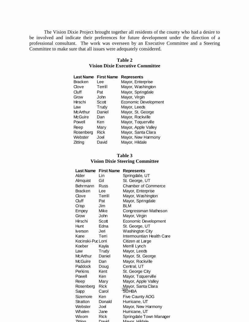
359
The Vision Dixie Project brought together all residents of the county who had a desire to be involved and indicate their preferences for future development under the direction of a professional consultant. The work was overseen by an Executive Committee and a Steering Committee to make sure that all issues were adequately considered.
Table 2
Vision Dixie Executive Committee
Table 3 Vision Dixie Steering Committee
Last Name First Name RepresentsBracken Lee Mayor, EnterpriseClove Terrill Mayor, WashingtonCluff Pat Mayor, SpringdaleGrow John Mayor, VirginHirschi Scott Economic DevelopmentLaw Trudy Mayor, LeedsMcArthur Daniel Mayor, St. GeorgeMcGuire Dan Mayor, RockvillePowell Ken Mayor, ToquervilleReep Mary Mayor, Apple ValleyRosenberg Rick Mayor, Santa ClaraWebster Joel Mayor, New HarmonyZitting David Mayor, Hildale
Last Name First Name RepresentsAlder Lin Springdale, UTAlmquist Gil St. George, UTBehrmann Russ Chamber of CommerceBracken Lee Mayor, EnterpriseClove Terrill Mayor, WashingtonCluff Pat Mayor, SpringdaleCrisp Jim BLMEmpey Mike Congressman MathesonGrow John Mayor, VirginHirschi Scott Economic DevelopmentHunt Edna St. George, UTIverson Jeri Washington CityKane Terri Intermountian Health CareKocinski-PuchlikLorri Citizen at LargeKoeber Kayla Merrill LynchLaw Trudy Mayor, LeedsMcArthur Daniel Mayor, St. GeorgeMcGuire Dan Mayor, RockvillePaddock Doug Central, UTPerkins Kent St. George CityPowell Ken Mayor, ToquervilleReep Mary Mayor, Apple ValleyRosenberg Rick Mayor, Santa ClaraSapp Carol SUHBASizemore Ken Five County AOGStratton Donald Hurricane, UTWebster Joel Mayor, New HarmonyWhalen Jane Hurricane, UTWixom Rick Springdale Town ManagerZitting David Mayor, Hildale
360
The Resource Management Plan and the General Plan will be a template for all public land related decisions allowing the county to measure pubic land management decisions and management practices.
Section Two Legal Authority
The authority for Washington County to plan for the management of natural resources within the county derives directly from state law. In addition to this authority, provisions of federal law allow counties to participate in, and influence, the natural resource and land management plans of federal agencies both through use of duly adopted county plans and through cooperative agency participation in the planning efforts for the federal lands. This section is intended as a broad outline of the parameters for influence, not as an exhaustive dissertation of all possibilities. County Planning Authority: Section §17-27a-401 of the Utah code provides that “each county shall prepare and adopt a comprehensive, long-range general plan,” which addresses, among other provisions, the:
1. Present and future needs of the county; and
2. Growth and development of all or any part of the land within the unincorporated
positions of the county. It may also provide for: class=Section2> 1. Health, general welfare, safety, energy production, transportation,
prosperity, civic activities, aesthetics, and recreational, educational, and cultural opportunities
class=Section3> 2. The efficient and economical use, conservation, and production of the
supply of: a. Food and water, b. Drainage, sanitary and other facilities and resources, c. The use of energy conservation and solar and renewable energy resources, d. The protection of urban development,
361
e. The protection or promotion of moderate income housing, f. The protection and promotion of air quality, g. Historic preservation,
h. Identifying future uses of land that are likely to require an expansion or significant modification of services or facilities provided by each affected entity,
i. An official map 3. In addition, the law provides that the Plan may define the local customs,
local culture, and the components necessary for the county’s economic stability. (Utah Code §17-27a-41 (4) Moreover, a county may get access to certain data gathered and held by state agencies that may be of assistance in the county’s planning process. (Utah Code §17-27a-402) However, the authority to plan does not give the county any direct jurisdiction over lands owned by the state or federal governments. (Utah Code §17-27a-304.
Federal Land and Natural Resource Planning: Two of the major federal landowners in Utah, the Bureau of Land Management (BLM), and the National Forest Service, are required to engage in land and natural resource planning processes, which can affect the use and development of natural resources. The Bureau of Land Management is required by Section 202 of the Federal Land Policy and Management Act of 1976 [FLIPMA] to “develop, maintain, and... revise land use plans which provide by tracts or areas for the use of the [BLM] lands.” Similarly, the Forest Service is required to “develop, maintain, and... revise land and resource management plans for units of the National Forest System.” (16 U.S.C. 1604(a) Coordination and consistency with state, local and tribal government plans: Both the BLM and the Forest Service are required to coordinate their land and resource planning efforts with those of state, local. And tribal jurisdictions. For example, the BLM is required to: 1. Become appraised of State, local and tribal land use plans 2. Assure that consideration is given to that State, local and tribal plans that
are germane to plans for public lands 3. Assist in resolving.... inconsistencies between Federal and non-Federal
Government plans. (43 U.S.C. §1712(b)(9) Specifically, state and local officials are “authorized to furnish advice to the [BLM] with respect to the development and revision of land use plans.... guidelines....rules and regulations for the public lands.” (43 U.S.C. §1712(b)(9). This is significant because land use plans adopted by the BLM are required to “be consistent with state and local plans to the extent
362
consistent with Federal law and the purposes of [FLPMA]” (43 U. S.C. §1712(b)(9). The duly adopted regulations of the BLM further define this consistency requirement by requiring that the BLM’s resource management plans shall be “consistent with officially approved or adopted resource related plans, and the policies and programs contained therein, of....State and local governments, and Indian tribes, so long as the guidance and resource management plans are also consistent with the purposes, policies, and programs of federal laws and regulations applicable to public lands.” (43 C.F.R. §1610.3-1) The BLM regulations also provide that “in the absence of officially approved or adopted resource management plans of State and local governments... [Federal] resource managements plans shall, to the maximum extent practical, be consistent with officially approved and adopted resource related policies and programs of state and local governments.’ However, as before, this consistency only applies to the extent the policies and programs are “consistent with the policies, programs, and provisions of federal laws and regulations applicable to public lands.” (43 C.F.R. §1610.3-2(b). The Forest Service is required to coordinate “with the land and resource management planning processes of State and local governments.” (16 U.S.C. §1640(a). The Forest Service’s planning regulations state that “the Responsible [Forest Service] Official must provide opportunities for the coordination of Forest Service planning efforts with those of other resource management agencies.” Furthermore, the agency’s planning regulations provide that the Responsible Official should seek assistance, where appropriate, from other state and local governments.... to help address management issues or opportunities.” (40 C.F.R. §1506.2(d). Federal Planning Criteria: Counties may use duly adopted plans, programs or policies to directly influence federal natural resource and land planning efforts by informing the federal agencies of the plans and their provisions. As part of these plans, counties may want to make known their interpretation of the criteria the federal planning agencies must consider as land and resource management plans are developed. This could, for example, be used to define, among other things, the desired future conditions for the county’s economy, lifestyle, or recreational needs of the citizens, and the necessary use of the federal natural resources to achieve these desired future conditions. Forest Service: The National Forests were originally set aside to provide a continuous supply of timber and for the protection of water sources for local communities and agricultural needs. Later, through the adoption of the Multiple Use Sustained Yield Act of 1960, Congress determined that the forests should be “administered for outdoor recreation, range, timber, watershed, and fish and wildlife purposes,” which purposes were declared to be “supplemental to, but not in derogation of” the original purposes. (16 U.S.C. § 528)
363
The Forest Service is required to “use a systematic interdisciplinary approach to achieve integrated consideration of physical, biological, economic, and other sciences” in its land and resource plans. The Forest Service must assure that the plans “provide for the multiple use and sustained yield of the products and services obtained there from in accordance with the Multiple-Use Sustained-Yield Act of 1960, and, in particular, include coordination of outdoor recreation, range, timber, watershed, fish and wildlife, and wilderness.” The plans must determine forest management systems, harvesting levels [of timber] and procedures,” based upon all of the uses mentioned above, the definitions of multiple use and sustained yield as laid out in the law, and the availability of lands and their suitability for resource management. (16 U.C.S. §1604(b) and (e). The regulations of the Forest Service specifically define principles of planning Forest Service’s natural resources. (36 C.F.S. § 219.3) Land management planning is an adaptive management process that includes social, economic, and ecological evaluation; plan development, plan amendment, and plan economic, and ecological evaluation; plan development, plan amendment, and plan revision, and monitoring. The overall aim of planning is to produce responsible land management for the National Forest System based on useful and current information and guidance. Land management and planning guides the Forest Service in fulfilling its responsibilities for stewardship of the National Forest System to best meet the needs of the American people. (36.C.F.R. § 219.3(a). The Forest Service is also required, as part of the development and interpretation of information for plans, to consider and incorporate the concept and conditions of sustainability. “Sustainability has been interrelated and interdependent elements; social economic, and ecological.” (36 C.F.R. § 29.10). The overall goal of the social and economic elements of sustainability is to contribute to sustaining social and economic systems within the plan area. To understand the social and economic contributions that National Forest System lands presently make, and may make in the future, the [Forest Service] must evaluate relevant economic and social conditions and trends during plan development (36 C.F.R. § 219.10(a). Expectations for ecological sustainability as well as ecosystem and species diversity are also provided. Bureau of Land Management: FLPMA provides that the BLM must manage the lands under its jurisdiction (called public lands) “in a manner that will protect the quality of scientific, scenic, historical, ecological, environmental, air and atmospheric, water resource, and archeological values” and will provide for, among other things, “outdoor recreation and human occupancy and uses,” and “food and habitat for fish and wildlife and domestic animals.” However, the BLM must specifically
364
manage the public lands “in a manner which recognizes the Nation’s need for domestic sources of minerals, food, timber, and fiber from the public lands.” (43 U.S.C. § 1701 (8) and (12). The BLM is required to “use and observe the principles of multiple use and sustained yield” and, just as the Forest Service must “use a systematic and interdisciplinary approach to achieve integrated consideration of physical, biological, economic, and other sciences” in the preparation of its plans. (43 U.S.C. § 1712(c)(1) and (2). The BLM must also “consider present and potential uses of the public lands” and “provide for the compliance with applicable pollution control laws, including State and Federal air, water, noise, or other pollution standards or implementation plans.” (43 U.S.C. § 1712(c)(5) and (8). Multiple-Use and Sustained Yield: Both the Forest Service and the BLM are required to mange the lands under their jurisdiction pursuant to the principles of “multiple use” and “sustained yield.” These terms have been defined within the provisions of FLPMA for the BLM and within the provisions of the Multiple-Use Sustained Yield Act of 1960 for the Forest Service. Both definitions are lengthy and worthy of careful study. It is apparent that the definitions are not crystal clear, leading to differing interpretations concerning development or preservation of the natural resources and the environment. The definitions do state, however, that multiple uses are to be considered in the context of the best combination of land use that meet the present and future needs of the nation with respect to recreation, range, timber, minerals, watershed, fish and wildlife, and natural, scenic, and historical values. “Furthermore, it states that these resources are to be managed in a “harmonious and coordinated” manner that does not lead to “permanent impairment the productivity of the land and quality of the environment.” Finally, multiple use does not, by definition, mean the greatest economic return or the greatest unit output” for the natural resources. (43 U.S.C. § 1702 c) See also (16 U.S.C. § 531(a). For the Forest Service, the “establishment and maintenance of areas of wilderness” is specifically determined to be consistent with the principle of multiple use. (16 U.S.C. 529). The term “sustained yield” is defined to mean the achievement of a “high level annual or regular periodic output of the various renewable resources of the public land consistent with multiple use.” (43 U.S.C. § 1702(h). Se also 16 U.S.C. § 531(b). National Environmental Policy Act and Cooperating Agency Status Preparation of land and natural resource management plans by BLM and the Forest Service is a major federal action requiring the preparation of an Environmental Impact Statement (EIS) under the provisions of the National Environmental Policy Act (NEPA). (42 U.S.C. § 4231 et. seq.) NEPA requires federal agencies to fully disclose the nature and condition of the environment within the area of interest. Under NEPA, agencies must formulate various alternatives for proposed management, and to compare those alternatives to a “no-action” alternative of continuing the current management scheme. NEPA specifically requires the
365
agency preparing the EIS to seek decisions that, among other things, “attain the widest range of beneficial uses of the environment without degradation,” “preserve important historic, cultural and natural aspects of our national heritage,” “achieve a balance between population and resource use which will permit high standards of living and a wide sharing of life’s amenities.” (42 U.S.C. 4331 (b). The development of an EIS by a federal agency as a part of the process to decide upon a land and resource management plan or proposed project has a number of well established steps. Each of these steps provides as an opportunity for comment by local government based upon their own plans and policies. These steps, in general, are: 1. The “scoping” of the issues 2. Preparation of an analysis of the management situation 3. Preparation of the various alternatives with the associated necessary
management scenarios and conditions 4. Issuance of a “draft EIS” for public comment 5. Issuance of a final EIS and the “proposed record of decision,” which lays
out the proposed final decision including the terms and conditions for management of the lands and natural resources for the life of the plan or for that specific project
Issuance of the proposed record of decision is followed by a period for protest by interested parties, which, upon resolution of the protests, is followed by adoption of the record of decision and implementation of the plan. For plans of the BLM, the Governor of the State is given an opportunity for a consistency review immediately following the issuance of the Proposed Record of Decision. BLM is required to “identify any known inconsistencies with State or local plan, policies, or programs,” and to “assist in resolving, to the extent practical, inconsistencies between Federal and non-Federal Government plans.” The Governor is given sixty (60) days to “identify inconsistencies and provide recommendations in writing” in response. The BLM must accept the recommendations of the Governor if the BLM State Director determines that the recommendations “provide for a reasonable balance between the national interest” and the State’s interest. (43 U.S.C. §1712(b)(9) and 43 C.F.R. § 1610.3-2(e). See also 40 C.F.R. - 1506.2(d). The Federal Council on Environmental Quality has issued regulations related to the implementation of NEPA. One of these regulations provides for the elimination of duplication with state and local processes. The regulation requires agencies to “cooperate” with state and local agencies to the fullest extent possible to reduce duplication between NEPA and state and local requirements. This cooperation specifically includes:
366
1. Joint planning processes 2. Joint environmental research and studies 3. Joint public hearings 4. Joint environmental assessments (40 C.F.R. § 1506.2(b) The Council on Environmental Quality has also supported an invitation to state and local governments to become “cooperating agencies” in the preparation of federal land and natural resource management plans and associated EIS’s. The invitation to become a cooperating agency is not based on the fact that state or local governments are entities that may be affected by the outcome of the process. Instead, cooperating agency status is specifically based upon state or local government’s position as professionals having jurisdiction by law in the planning area or professionals holding special expertise in an issue that will be addressed in the analysis or decision. (memo from James Connaughton, Chairman of the CEQ). This status does not relieve the federal agency of the responsibility as the decision-maker, and does not guarantee a decision that the responsibility as the decision-maker, and does not guarantee a decision that the cooperating agency may necessarily favor. Cooperating agency status does allow the cooperators to participate in the scoping process, the inventory of data and analysis of the current situation process, the preparation of alternatives, the impact analysis, and in the current situation process, the preparation of alternatives, the impact analysis, and in the preparation of the draft and final EIS’s. Participation as a cooperating agency in federal planning efforts will specifically require the cooperators to respect the timing and confidentiality inherent in the federal process. Failure to adhere to these conditions may lead to revocation of cooperating agency status. BLM has proposed a regulatory rule change that would solidify the cooperating agency concept in BLM planning, stating that a “cooperating agency relationship” would implement the requirement under FLPMA to coordinate with state and local government (69 F.R. 43378.) State Planning Coordinator Responsibilities: The State Planning Coordinator is authorized to prepare plans, programs, and policies for the state that, among other things: 1. “incorporate the plans, policies programs, processes, and desired outcomes
of the counties where the federal lands or natural resources are located, to the maximum extent consistent with state and federal law...”
2. “develop, research, and use factual information, legal analysis, and
statements of desired future conditions,” for the regions of the state “as necessary to support the plans, policies, programs, processes, and desired outcomes of the state and counties where the federal lands, or natural resources are located”
3. Establish and coordinate agreements with federal agencies that facilitate state and
367
local participation in the development, revision and implementation of federal plans.
(Utah Code § 63-38d-401) The state law continues by establishing findings that shall be considered by state and local governments as they interact with the federal agencies in the preparation of federal land and natural resource management plans. These findings provide the framework for the necessary considerations of state and local plans and policies, which the federal agencies are required to consider s a part of their planning efforts. The findings include a definition of multiple use that emphasizes support for state and local plans that include watersheds timber, food, fiber, livestock and wildlife forage, and minerals, necessary to meet the present needs and future economic growth and community expansion, as well as meet the recreational needs and the personal and business related transportation needs, of the citizens of the state without impairing the productivity of the land. The findings also indicate, for example, that; the federal government must seek water rights within the state appropriation system; federal agencies must support the purposes of the school trust lands compact in their land management decisions; development of the solid, fluid, and gaseous minerals of the state is important to the state’s economy ; wildlife is an important part of the recreational opportunity; within the state, and the economy, Furthermore, the findings indicate parameters for state and local government support or opposition to specific federal land planning issues such as areas of critical environmental concern, wild and scenic river studies, exchanges of land, agricultural production and open space management of forests in a healthy manner, off-highway vehicle use, and predator control. (See Utah Code 63-38d-401(6) and (7) for the complete listing and findings.) Federal Advisory Committee Act: The Federal Advisory Committee Act of 1972 (FACA) was enacted to formalize and stabilize the process which federal agencies receive advice from the interested parties. It establishes conditions under which federal agencies may establish such committees; how they must be composed and chartered, and requires meetings and activities to be open to the public. FACA does not affect the requirement under FLPMA to coordinate with state and local governments, nor does it affect the establishment of a cooperating agency relationship. FACA also does not apply to any state or local committee or other group including land and natural resource utilization issues. (5 U.S.C. Appendix)
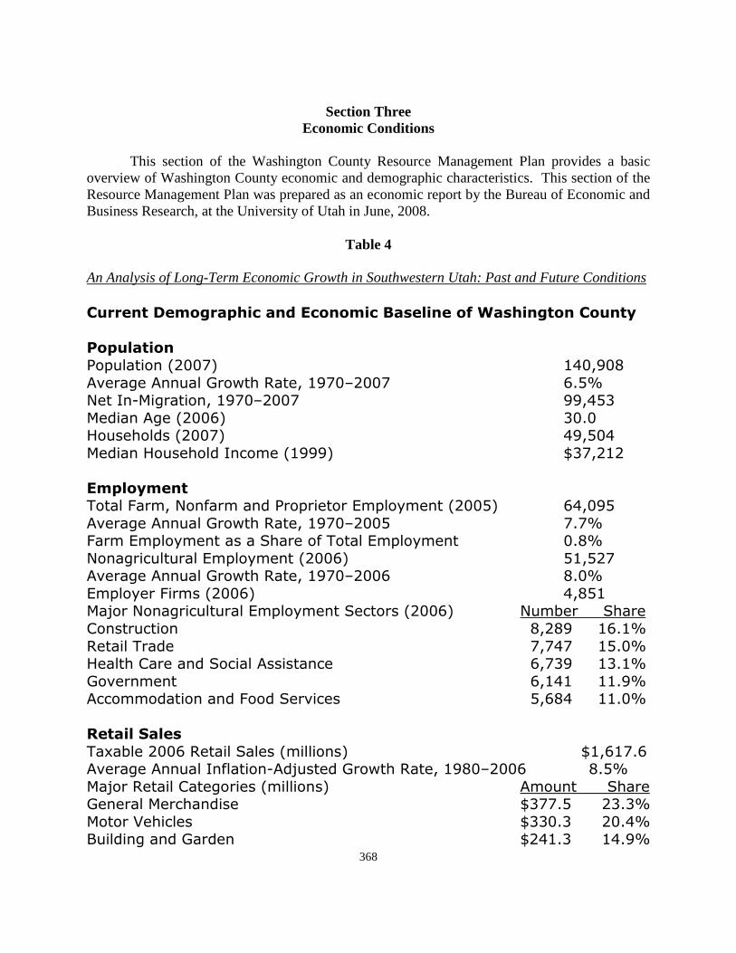
368
Section Three
Economic Conditions
This section of the Washington County Resource Management Plan provides a basic overview of Washington County economic and demographic characteristics. This section of the Resource Management Plan was prepared as an economic report by the Bureau of Economic and Business Research, at the University of Utah in June, 2008.
Table 4 An Analysis of Long-Term Economic Growth in Southwestern Utah: Past and Future Conditions �������������� �����������������������������������������
�� �������
����������� �� �� �� �
������������������������� �� � � !"#��$%&����������� �� � ����!'
&�(������� �� ' )��*����(*�� �� ���! �
&�(��)��*����($+�,������� -'������
� ������.����/��,�#�0��,�(����������1,���2,���� !� ��� �!
������������������������� �� ! � �"/��,1,���2,���*�3�����0.����1,���2,�� �"
#�����+�������1,���2,���� �� !��!��������������������������� �� � � "
1,���2��/��,*�� �� ���!�&�4��#�����+�������1,���2,��3�+���*�� �� #�,5��3����
6�*���+��� ������� �"
������.��(� ������! ")�����6����(3�+����**�*��+� ���'��' �"
�����,�� ������� �"�++�,,�(�����(/��(3����+�* !������ "
��������������
.�7�5��� �������3���*�,�����*� -����� ������������$0�����%�(4�*��(�������������� �� � � !"
&�4��������6��������*�,�����*� �,���3����������&��+��(�*� -'�� !�' '"
&����8���+��* -'' '� �"9���(���(���(� -��� '�� �"
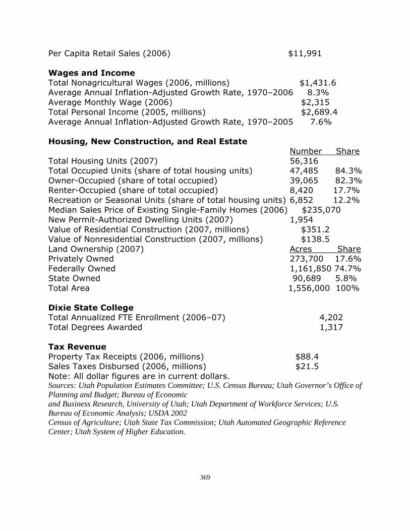
369
���6�����������3���*�� �� -������
����������������
.����#�����+�������:���*�� ��,�����*� -���'� ������������$0�����%�(4�*��(�������������� �� �� '"
�������&����2:����� �� -��'�!.�������*���$+�,��� !�,�����*� -����� �
�����������$0�����%�(4�*��(�������������� �� !� �"�
���������� �����������������������������#�,5��3����
.����)��*��;��*�� �� !��'��
.����<++����(;��*�*�����0��������*�����*� �����!�� '"
<���%<++����(�*�����0������++����(� '�� �!�� '"�����%<++����(�*�����0������++����(� ���� �� �"
��+��������3��*���;��*�*�����0��������*�����*����!��� �"
&�(��3���*���+��017�*���3����%/�,��2)�,�*�� ��-�'!� � #�����,��%�������=�(>������;��*�� �� ���!�
8�����0��*�(�����6�*���+����� ��,�����*� -'!� �8�����0#���*�(�����6�*���+����� ��,�����*� -�'� !
?�(<���*����� �� �+��*3������������2<��( ��'�� �� �"
/�(�����2<��( �������! �� �"3����<��( � ����! �"
.�������� ��!!�� � "�
��!����������������.���������=�(/.11����,���� �� �� ��� �
.����>�����*����(�( ��'���
"�!���#�����
�������2.�7��+����*�� ��,�����*� -�� �3���*.�7�*>�*5��*�(�� ��,�����*� -�� !
#���@���(�����0�����*����+�����(�����* Sources: Utah Population Estimates Committee; U.S. Census Bureau; Utah Governor’s Office of Planning and Budget; Bureau of Economic and Business Research, University of Utah; Utah Department of Workforce Services; U.S. Bureau of Economic Analysis; USDA 2002 Census of Agriculture; Utah State Tax Commission; Utah Automated Geographic Reference Center; Utah System of Higher Education.
370
An Analysis of Long-Term Economic Growth in Southwestern Utah: Past and Future Conditions Executive Summary ������������������ ������������� �������� � ������������������� � �� ��� ����� ������ ������������ � �� ����� �� �!���������� ���� � ��"��� ��� � �� �!������� ��� ��������� ��� � �� ������� ��� ���������������#����������� ������� ������� ��!�!����������!���������������������������$��%�������������������&����'�!������ ������ ������ �������������� ��� ��������������()&�!��!���������������� �� ����� ��!�!������� ������� ������� ��� ��� � ��� � �� � ��� �������� ��������� ���%��������������������*����+�)�!���������� ��������,� �� �� ������������������������� ����������-�!����������� ������������������������������������������ ��������������$��%������������������ ��������� ��� � �� ������ ������ ������ ����������������!������� ����� ��� � ��� ���������� ������� �������!�!��������.������� ������$�����������������������������/��� ��������� ��� ������ !����� ����� ��� !�!������� ���� � ��� � �� ������� ��������� ��������������� �������� ������������� ������������!!��� ����������������������� ��� �������'��!���������� ������� ��!�!����������� ���� ��� �����!�������������������� �0�*��������/��������������� �����������1�� ������� ������� �� �!�������� ���� � ������ ������������� ��� � �� �������������� ���������� ��������� � �� �� ������� ������ ���������� ��� � �� ����� ��������� ��������� !�������� ������ ����� �������� �����������������������������!����������� ����������������������� ��������������������������������������� ������!�������������������������!���$��%������������������%��!��������� � ������� ��!�!�������������� ������+�������������� ���������� ��������������� ����������!�!����������� �����������������������'�)����� ����������������'��+�����%������ ��������������+��++��!��������)�!���������� ������� ��!�!����������� �������������%������� �� ������� �������� !�!������� ��� 2��!����� 3)��!�����4�� ������ ���� ��� � ��� ��� ������#�������������� � �������������������� � ���!�!�������3������������ ���!�����������"������������ ����������� � ��� �������4�� ��� ��� �������� � ��� 2��!������ ������������ ������ ������� ������ �������������!!������������������������������$��%��+�����������!�������� ��������)��)%��� ���������� ��� ��� ������� �������'�!������ ������������������5������ ���������� �������������������(�&�!�������$��������������6������� � ����������� �� ����� ����!��������"������ ����������������� �����������������������!������������ ����� ����� ������������
371
�������&'�((���������6�������� ������� ��������������������������,�������� ��#7����������������6�������� ��������������������%��+���
An Analysis of Long-Term Economic Growth in Southwestern Utah: Past and Future Conditions �� ������� ������ ��� � ��� ���� � ���� ����� � �� ����� ���� ������� �������� ���� ��� �� ������ �.���������������� ���� ����������� 8�������� ��� %��+�� ����� ���� �������� ������ ������ %������6�����������������������������'������������������������)�%�����9���������� � �� ��6�� ��!�������� ������ ���� � �� !������ ������ ���������#��6����� ������ �������������:'������������ �������� ���:��&� �������� ���%��+�� ���������� ��� ���#� ���� ��� ���� ������ ��� � ����������� ����������������� �������� ���� �������� �������������:%��'�������������:%�(�)����%��+�3������������%��+�������4��������������������(�!������������� ����������������������������������&�!������������������%��+���;���� ��� � �� ����� �� ������� ��!������ ��� �������� ������ ������������������ ���!����������#;���<��������������$2� ��<�.���9��������;����������������!�������������������!��!����/���� ������������ �������� ��������!��������� �����*������� ������������� ���������#��������5�� �����������!��!��������� �������������"�� ������������0������ �������� ����� ������������������ �������������"�������������� ���������!����������/�������������#�����!�����������#������������������ ������������� ���� ���������0������&��!���������!��!������������������ ��������������������������������� ���� ����� ������������ � �� ������� � ��� ��� � ���� 3'+�!�����4� ����� ����$��� ������� 0���� ���#� ��� ��� ��#������������������������� ���������!�����������0�*������0�������'�!�������������������� ����������������!���������������� ��������� �� ������������ ���������� �������������������������)�!������������ �������������3��������� �� ��������������� � ���������=����;������������=;4�����>$�=0������ �����)�!�������>$�=0 �� ������������������������ �������������!�������������� ����������� ���=;� ������������������������!��������������� ������������������������������������������������������?���� ��!��������������=;� ��������������������������������!����������!���������$�� ������ ������ � ��������� ��� �!������ �������� ��!�� ���� ����� � �� ������� !������ ����� �������������������������� ����������"����������������� ������������� ��� � ����������� ��������"��� ��� � �� ����#��������� ����� �������$��%��+�� �����!������������+�!����������������������������� ��������3:��+�����������������4������ ���� �� �� ����������������!����!�������:��������� ���!������� ����� �������������� ������������������ ������� ��!�!��������.!��������������������������������������� �!!���������������� ���������� ���� ����������������������!�������%��+����������������������>����=�"������������:�����������������!����!��������������:'���%���
372
$��%�������� ������������ �� �������������������)+�(�+�������9����������������������������������������%�%�!��������� � �� �������������!������!������� ����#� �������������� ������?��� ��&��&')����!���� ������'%�!���������� ����#���!���� ���� � �� ��������������!������������������;���� ������#� ������� ������� �� ��������������� �������������������%������?���� ��!����(������������ ��������������������� ������������� �����!������ ������������ �������������� ������������������� ����������!������������������ ���������
An Analysis of Long-Term Economic Growth in Southwestern Utah: Past and Future Conditions � ������������������!������������������ ��������������������� ���������� ����������������!����������������������@�����A������������$���������������� ����������!����� ���������������������� ����������� ���������)� ������ ������������� ������������:%������������8��� ��!������������� � ����������������������������������� ������ ������������� ��� �.������� :������������ ��������� � ��� ��"�� %��&� ��� %���� ��� � �� !����� ��� ������������������ ������!����� ��� � �� ������ ������ ��������������0� ����� �� ����� �������� ��� ���%��+���� �:�'&�������������������������� ������������� �� ������� ���������������������!�6���� ������ ������� ����� �� ������ ��� � ��$2��<�.���;������� ������� � �� � �������� ��!����� ���%��%����������:���&�����������<�.���>������������������������������������������ �� ��������������� ������������ ���������������� �� ����� �� ��6�� ��!������ ��� ����� ������ � �� �������� ������ ��������� �� ���� �����������������������������������������������!��������B��������� ������� � ��� ��!�������<�.������� � ��!����%)�������������� ������('��������*������#����� �7��������� ��� � ����'�C'%� ��������� ����� ���&�%�%� ���%��+C����>�������'��� �������������� � �������������� ������������ ���������B���������!��"������&�)'(����%��(C�&����� ���������������������� ��!�������������3��������4��� ������������������ ������������������ �������������������<�.������%��(C�&��������������3�4�������������� ���������"� �!������������������ ����������������� ������ 3%4� ���������� ������� ����������� !������ ���� ���!�� ��� � �� <�.��� 0!!�������� ������� ��������� ���� 3(4� �� � ����� ��� �� ���� �!� !������ �7����� �%� ������ ��� !�� ����������������)���B���������������!�����������!����%��'�� ������������������ � ������������8�B����<�.������� �!���� %����� � <�.�� �� �������� ��������� ��� �+�� ��� �� ������ ��� &���'�� ���� ���� 8�B� �������������������%����������������(�)+%���>������ ����'�#'%����������������� �������������������������������������������������<�.��� ������������ &���!������� ����%)'� ��� ��(���� ;���� ��� � �� ������� ������� ��� <�.��� ��� ��������� ����������� �� � ��������'+&����%��+C���� �<�.�� �������!�!���!����� ��� � ����������� �������� �����������������3+'&����'+&����%���4���<�.������������������� ��� �����������������������<�.�� ����� ��� ��������!����������������������3���!�����������%���C��4������������������$��%��+C����������������(&���� ��� �������������
373
�������� !� ����6��� ���� ������ ���%���C����� �� ������� ������ ��� ������� ���� ������� �����������3))4��������������3&'4���B������������� ����<�.������!�6���������������������������������� ������#� ������%�%���2������� ������ � �� ������! ��� ���� ��������� ���� � !�6�������� ��� � �� ��� ����� ������ ��������������������� ����������������!���������������������������� � �� ��� ������������� ���������.������������� ������� ����������������!�6���������������������������� �������8��� %���� ��� %�%������ ������� ����� �� !�!������� ��� �.!������ ��� ��!���� ������� ��� �''��+��!������ ���%���'+&��� ��� �!������� ���������� ������� �����)���!������ �������,�.�������� � ��
������������������ ��������&���!������and � ���������������������� ��������%�)�!��������
An Analysis of Long-Term Economic Growth in Southwestern Utah: Past and Future Conditions �?��� ������ !�!������� ��� � �� ��� ����� ������ ����� ������� ���� ������������ ��� ��� �������������� ���������� ������� ������ ������ ����� '%� !������ ��� � �� !�6������ �������� ��� � ������� ��!�!�����������%�������%�%������� ���������� ��!������)�!���������!��!�������������� ����� �������������������� ����������� ����"���#����!�!������� ���!�6������ ��� ���� � �� ������������� � ��� ��!����� ��� ��*��� ���%�%���� �����������������������!��������������� �����������'�����+&�������������� �������������� ���� ����������%������ ���� ���#����!�!����������������������������'��!�����������%'�(%+����%����������%+�����%�%������� �������������������������������������������������������������� �� �� ���������������!�!����������!�6������������������������� ������ ��� ����"���#�������� ���#����!�!���������8���%�������%�%���� ����������#����!�!�������3+)D4����!�6������������������������������������&�!������� ���� ���� �� �� � ��� � �� ���������� �������(���!�������8� ��� ��������!��������� � ����������� !�!������� ��� � �� ������ ����� ��� ������� ��� ��� ������� ������ ��� %�%��� $�� ��������������� ����� � ��� �������� ��� 1�� � ��� !�6������ ��� ���� ���� ���� � ��� � �� ��������#����!�!������5�� �����������>����=�"���1�� ������<�������� ����!��������!�6�������������� �������������� ���� �������������������������6�����������'��!��������� ���� ����6������� � ��� � �� ������ ����%��)� ���%�%������ � ��������� � ��!�������(�!�������������6�������� ���������������������� ��������������!�����+��!���������%��)���� ���������#���������������������������������� ���� ���������3%���!�������������4������������������������ 3�+�� !�����4�� !����������� ���� �������� �������� 3�)�� !�����4�� ���� ������ ���� ��!��������3�&(�!�����4��/��������������������������� �������������!�6���������������������� ��!�������� ������� ������������ ��!�������� � ����!�6������ ��� � �� ������ ��� � �� �������� ��� ��������� ���� ���� ����������$��%��)��� �������� ��� ��������!������������������%�!����������%�%�������� ������!�6���������������������)�%�!��������� �� ����#���� ���� � !��!����� ��� ��� ������� ������ ������ ���� ���������� � �� ���������������� ���!������ ���� �� ��������� ������ �������� ���� ������ ����� �������������� �����
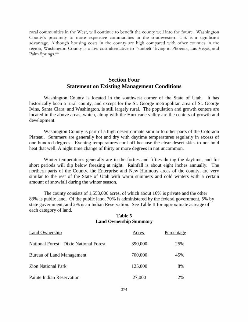
374
������������������ ��������������������������������� ������������������� ����������� ������������ �� !�.������ ��� ���� �.!������� ����������� ��� � �� ��� ������� 1�>�� ��� �� ����������������������� 0�� �� � ������ ������ ��� � �� ������ ��� �� � ���!���� ��� � �� �� �������� ��� � ������������ ���������������������#�������������������E������F�����������- ����.��=���G����������-����>!�����HH
Section Four Statement on Existing Management Conditions
Washington County is located in the southwest corner of the State of Utah. It has historically been a rural county, and except for the St. George metropolitan area of St. George Ivins, Santa Clara, and Washington, is still largely rural. The population and growth centers are located in the above areas, which, along with the Hurricane valley are the centers of growth and development. Washington County is part of a high desert climate similar to other parts of the Colorado Plateau. Summers are generally hot and dry with daytime temperatures regularly in excess of one hundred degrees. Evening temperatures cool off because the clear desert skies to not hold heat that well. A night time change of thirty or more degrees in not uncommon. Winter temperatures generally are in the forties and fifties during the daytime, and for short periods will dip below freezing at night. Rainfall is about eight inches annually. The northern parts of the County, the Enterprise and New Harmony areas of the county, are very similar to the rest of the State of Utah with warm summers and cold winters with a certain amount of snowfall during the winter season. The county consists of 1,553,000 acres, of which about 16% is private and the other 83% is public land. Of the public land, 70% is administered by the federal government, 5% by state government, and 2% is an Indian Reservation. See Table II for approximate acreage of each category of land.
Table 5 Land Ownership Summary
Land Ownership Acres Percentage National Forest - Dixie National Forest 390,000 25% Bureau of Land Management 700,000 45% Zion National Park 125,000 8% Paiute Indian Reservation 27,000 2%
375
State and Institutional Trust Lands 75,000 5% Private ownership – 236,000 16% including city and county lands **Five County Association of Governments website: fcaog.state.ut.us Current Resource Management Conditions: 1,553,000 acres 100% Partnerships: The county recognizes the efforts that the various management agencies have made to inform the county of planning processes underway, or decisions that have been made. The cooperative efforts in Washington County have generally been at a reasonable level. Obviously, there is always room for improvement on the part of the county, and on the part of the other agencies. Given the county’s responsibility to all county residents, as well as the county’s overall responsibility for the welfare of visitors to the county, whether they are on private or public lands, it follows that the partnership between the managing agencies and the county should be more than simple cooperating agency status. What the county does impacts the public lands, and what the agencies do impacts the residents of the county. Therefore, every effort should be made, at all levels, to coordinate activities, jointly plan as much as possible, and cooperate fully on all levels. That should be the goal of the county and agencies involved in the county. Consistency: Washington County enjoys a positive relationship with all of the agencies that manage the federal and state lands in the county. Our association with the various managing agencies during the process that led to the preparation of the county land use plan that was submitted to Congress showed a great degree of cooperation. However, in some instances, county input is gathered after a significant amount of planning has already been done, not always allowing the county to effectively meet our responsibilities and expectations as a planning partner. The county will continue update this county public resource management plan in an effort to more efficiently address the many public land issues that arise, and more fully meet the needs of all the many stakeholders for whom it has responsibility. Local Economic Impact: The county is concerned that insufficient weight is often times given to economic impacts when considering public land management practices. There have been changes in management philosophy over time, much of it due to Congressional rules and regulation changes. Often local managers must work within very narrow parameters to solve complex and difficult land use problems. This is further complicated by intense pressure from various advocacy groups,
376
individuals who have had long-standing use access to public lands in ways which may now be limited by changing philosophies. These changes impact the ever increasing numbers of people who use the lands. The concern of the county is that, in light of all of these factors, socio-economic impacts often become the last consideration in the planning processes and management decisions. This concern is two-fold. First, while the county gives substantial weight to certain subjective values, such as “sense of community”, rural atmosphere, historic relevance, and local culture and custom when planning, the managing agencies seem limited within their planning processes in their ability to give adequate consideration to such concepts. Second, there is some difference between what the county would consider economically feasible, and what the agencies deem to have economic value. Such concepts are clearly open to much interpretation, given the many ways to evaluate, assess, and balance potential values, both real and conceptual in any planning process. Washington County cannot overstate the importance of giving sufficient weight to all potential socio-economic impacts when public land management decisions are made. The economic needs of the county must be considered when developing plans and making recommendations that affect the custom and culture of the county. This concept is further discussed in the goals and objectives section of this plan. Another important example of underestimating economic impacts by federal agencies is in the area of transportation and, and RS2477 rights-of-way. The recreation community is wide spread and growing, and generally the impact on communities is very positive. Several extensive and connecting trails systems run throughout the county, and the benefit to the county from recreational activities is very substantial. Yet, it seems sometimes that management practices appear to be more focused on controlling these activities than enhancing appropriate opportunities. The county is also concerned about the fact that much of the land in the county is being closed to mineral exploration. The western part of the county has not been explored thoroughly with an eye to determining the true mineral potential for more large scale mineral developments even though individual permits and some minimal exploration has been done for the past 150 years. In addition to sand and gravel resources, which continually become more difficult to find and develop, it is known that there are likely other resources yet undeveloped in the county. We know that gold exists in certain areas. Other, often rare, minerals are also known to exist. The western part of the county, as well as some other parts, has not been adequately studied to see what might be found. The county believes that minerals should be extracted with great care for the environment, but the good of the environment should not be used as a tool to close public lands to mineral extraction. There should be a good balance, and due consideration should be given to the economic importance to our natural resources on public land to the county’s overall economic health. Washington County is the only place in the world with enough ore to mine gallium and germanium. Relative Impacts: The county acknowledges that the public land belongs to the national public as a whole.
377
However, this does not diminish the fact that the county is more directly affected by local management decisions than those who live outside the county or the state. Washington County is directly impacted by decisions regarding public lands, and is personally accountable to its residents, and therefore should have a significant role in the management decisions made regarding public lands within its boundaries. There are many stake holder and advocacy groups with seemingly endless proposals for management of the public lands in Washington County. However, the county asserts that all stakeholder interests in the care and use of our public lands are important, and no single special interest should rise above others nor sway federal managers from their decision-making process, particularly after plans have been completed through the public planning process. The county supports managing timber resources, utilizing insect-killed timber, improving wildlife habitat, watershed conditions, and fire control. The county also supports preserving the natural scene, and maintaining AUMs for agriculture, a long -term use, to support the local economy. But there is a concern that more and more historically used activities are under increased scrutiny, and the potential for continuing to create special use lands are becoming more and more prevalent. Washington County has always been a multiple use county. At the present time, with the passage of the land bill by congress, 30 percent of the public land in the county is now single use land. Consequently, lands set aside for single purpose use provide conflict with existing uses, putting undue pressure on federal managing agencies to justify their management decisions and often requiring them to spend large resources of time and money defending those decisions in court. The county’s position on designation of special areas is addressed in the policy section of this plan. It is of concern to the county that local land managers seem to have continually increasing pressures which limit their being able to manage the land resource for the best good of the resource and the public. National scrutiny of every action, combined with the continual litigation over every decision, creates a management problem to a large extent, and limits the ability of those who are closest to the land to make decisions which are best for the land. Washington County believes that this is an unfortunate by-product of interest advocacy, rapidly growing use, and ballooning national interest in public land management issues, as well as a number of other factors. It is not a healthy atmosphere for managing our public lands. It is the county’s hope that cooperative efforts will assist the federal and state managers in their process of making management decisions, and in defending those decisions, with the result being a healthier environment for the resource as well as the user.
378
Section Five: Statement on Desired Future Management Setting
The difficulty in defining an ideal future management setting lies in the fact that the county does not control all of the lands within the county boundaries. With federal and state lands surrounding all of the private land, there are many management decisions that are made outside the county’s influence and reach. No future condition can be ideal unless the county is able to appropriately influence public land management policy in accordance with Federal Law. An ideal situation would be a blend of purposes and vision, shared by the various public land managers and county leaders in an ongoing effort to protect and conserve our natural resources while working to accommodate growth, planning appropriately for an increased interface between public and private lands, and preserving for public use and viewing, important historic sites both on public and private lands, while also working for increased economic value. To achieve this blend of vision it will require efforts on the part of both the county and the public land managers. While the county’s relationship with our land managers is good, we desire to make it even better. Due to the interface between public and private lands, county land use policies are always influenced by surrounding public land management policies. The goals of the county are directly tied to state and federal land management practices. The key to future land use management rests on the ability of the county to increase the frequency and effectiveness of a collaborative process. Elements of a Desired Future Management Setting: In spite of the growth of Washington County, there is still a good mix of rural and urban development due to its unique mix and location of public and private lands. The county would like to continue the support orderly residential, commercial, industrial, and agricultural growth. Development should occur in an orderly manner, and in locations that enhance and preserve the socio-economic well-being of the residents while also contributing to the economic stability of the county. The county will work to identify and preserve appropriate open spaces, connecting trail systems, agricultural areas, and transportation systems, as well as potential commercial and industrial areas, The county has been, and will continue to be, an appealing place to live, work, and visit. It is an area made up of vibrant communities, productive agricultural enterprises, and valuable natural and cultural resources. In order to preserve vital recreational opportunity, protect the rural lifestyle of many of its residents, encourage and preserve historic agricultural activities, and maintain and provide adequate services, the county has encouraged growth to take place inside existing communities and infrastructure as much as possible. All planning, zoning, and growth must take into account the values important to the residents of the county as identified through the Vision Dixie planning process. Due to the proximity of large areas of public land, the county will work to enhance opportunities provided by the variety of public lands in the county, while working to minimize the impacts from those same lands. The county will remain sensitive to private
379
landowner rights and will work to balance those rights with the public interest. Basic Future Management Principles: Federal lands should be managed in a way that protects and improves the health, safety, and environment of our citizens, and improve the performance of the economy without imposing unacceptable or unreasonable costs or impacts to the local structure. The county recognizes that the private sector and private markets are the best engines for economic growth, that regulatory policies should respect the role of state and local governments; and public lands policies and regulations should be effective, consistent, practical, and understandable. Public land management practices should work to accomplish the following: 1. Protect the integrity of environmental systems and natural resources 2. Preserve resource based industries 3. Promote a robust, diverse, and stable economy 4. Minimize conflicts between land uses 5. Protect public health, safety, and welfare 6. Preserve culture, customs, heritage and economic diversity, and
7. Recognize and protect private rights in federal and state land resources including rights-of-way, grazing permits, water rights, special use permits, leases, contracts, and recreation use permits and licenses.
It is interesting to note the similarities between many these recommended public land policies, and the private land management policies that resulted from the Vision Dixie Project. The Vision Dixie Project provided a summary of guiding principles to guide the development of the private land in the county. These are listed as follows: 1. Plan Regionally, Implement locally, 2. Maintain Air & Water Quality, and conserve water, 3. Guard our “signature” scenic landscapes, 4. Provide rich, connected natural recreation and open space, 5. Build balanced transportation that includes a system of public
transportation, connected roads, and meaningful opportunities to bike and walk,
380
6. Get centered by focusing growth on walk able, mixed-use centers, 7. Direct growth inward, 8. Provide a broad range of housing types to meet the needs of all income
levels, family types, and stages of life, 9. Reserve key areas for industry to grow the economic pie, 10. Focused public land conversion should sustain community goals and
preserve critical lands. In studying these principles more closely, many are directly related to those policies for public land maintenance listed above. For purposes of land use planning efforts, and management decisions on public lands in the county, federal and state agencies shall develop and maintain cooperating agency status for all major federal and state land management actions. Cooperative Conservation: The county supports state and federal land management that is based on cooperative conservation, meaning actions that relate to the use, enhancement, and enjoyment of natural resources, protection of the environment, or both, and that involves collaborative activity among federal, state, and local governments, private for-profit and non-profit institutions, other non-governmental entities and individuals. Federal land managers must facilitate cooperative conservation by fully involving local governmental entities including the county commission. In so doing, they should take appropriate account of, and respect the interests of persons with ownership or other legally recognized interests in land and its natural resources. They should also more fully accommodate local participation in federal decision-making, and provide that the programs, projects, and activities are consistent with protecting public health, safety, and welfare. The county will not give its support to projects unless a federal agency has appropriately involved local government entities. Customs and Culture: Major land uses of federal state lands in Washington County, include livestock grazing, harvesting of forest products, water source development, and a broad spectrum of recreation activities from primitive use to developed recreation sites, and both motorized and non-motorized use of roads and trails. It is this myriad of land uses that forms the basis for the customs and culture of the citizens of the county. The traditions of the citizens are based on continuing these land uses. Maintaining the county’s customs and culture includes these activities, and maintaining the uses that the Vision Dixie Project identified as being important to the county residents.
381
The customs and culture of the county is tied closely to the public lands. Close communication and cooperation with public land managers is a necessary part of maintaining the customs and culture of the county. Other important issues include the land’s inherent value as open space available for use by the public at large, the land’s natural role in providing habitat for flora and fauna, the protection of watersheds and significant scenic landscapes, and its role as a vessel for historical and cultural values associated with human use of the land. Washington County supports the maintenance and enhancement of the customs and culture of the county, and opposes any change in land use that does not evaluate, mitigate, and minimize impacts to custom and culture, and the economic growth and stability of the county. Federal managers shall incorporate the social, cultural, and economic needs of the county when developing plans or projects and making recommendations that affect the customs and cultural of the county. Furthermore, the consideration process used to assess impacts to county customs and culture shall be cited in federal or state land management plans as well as the steps taken to incorporate protection of the county’s customs, culture and historical heritage into each plan and project. The county will review and respond to federal and state land use and planning issues impacting the county’s customs and culture, and make recommendations pertinent to any issue in question. Responsible use of federal lands is a use that benefits the customs, culture, heritage, and economic base of the county. Federal and state agencies will notify the county of any actions, proposals, policies, or regulations which may impact the customs and culture of the county. The county will review and comment on such federal or state actions. Communication and coordination are two important aspects of maintaining a proper relationship between the county and the public agency’s. Local government agencies, including the county, cities and towns, the school district and the local state college, public health care providers, Five County Associations of Governments, and other local agencies, all have important and useful data and other information regarding economic and cultural trends that may not be available from state or federal data sources. It is the policy of the county that federal and state land managers seek out and take into account data and information available from local sources when developing plans and/or making recommendations, thus providing for close cooperation in all aspects of planning and decision making. Management of federal and state lands will recognize valid existing rights and interests in federal land. Livestock grazing established by permit and preference, mineral leases, mining claims, recreation permits, and concessionaire contracts, and rights-of-way form the backbone of the county’s communities, and their custom and culture. It is important that these values, as defined by the county’s customs, culture, and heritage,
382
be recognized as a resource as important as any other resource relating to public lands. The cities and towns, and the public lands surrounding them are deeply inter-connected and customs and culture must be recognized as a vital resource to be protected, enhanced, and managed in the same manner as any other important natural resource. In Washington County’s desired future condition, all public land management plans and policy making must take into account these community values, and must always reconcile any differences between this plan and federal or state management planning documents prior to adoption and implementation. The county’s desired future condition would include the following elements: 1. Collaboration, communication and cooperation is the key to a desired
future condition where public lands play such a dominating role in any goal-setting or planning within the county. The county seeks a balance of objectives with all stakeholders, while voiding conflicting interests that serve no useful purpose. This balance can only be obtained when collaboration is involved at every level of planning and policy-making, and when all stake holders have a role in developing management of the desired future county policy from the ground up.
2. Any desired future condition must also involve an expansion of the
tourism and recreation industry, and coordinating public land management policy that allows for and compliments this expansion. The public lands are a tremendous asset, and the county desires to more fully capitalize on the many recreational opportunities on the adjacent public lands within the county. This expansion with accompanying infrastructure will benefit not only county residents, but visitors to the county as well.
3. The county’s desired future condition must also include the continued
development of the natural resources of the county. This would include expanding the current natural resource industry, along with improvements to infrastructure, access and the permitting process. It should also include expansion of renewable energy.
4. In a desired future condition, the county’s customs and culture will be
protected as vital and important as any other natural resource associated with our public lands. Since the customs and culture of the county are inseparably connected with the surrounding public lands, public land management policy must account for the county’s customs and culture, and must recognize the importance of protecting, enhancing and preserving historic sites and uses, which are part of the county’s heritage, and making them available for public visitation. Part of our customs and culture is our system of transportation and rights-of-way for travel throughout the county. These are the things that make up the essential elements of its customs and culture.
383
Section Six
Planning Guidelines and Policy Statements
The policy statements contained herein are an outgrowth of planning efforts by the county in planning for both public and private lands in the county, the approval by Congress of the Washington County Land Use Bill, and the basic responsibility of the commission to care for the welfare of all the residents of the county. The county supports multiple uses, sustained yield management of federal and state lands, and will work with the various management agencies to maintain appropriate balance among all users and uses. Maintaining multiple use management practices on federal state lands is a high county priority. Maintaining adequate public access to federal and state lands and accompanying natural resources is also a county priority. The county acknowledges that the terms multiple-use and sustained yield may be interpreted many different ways. For purposes of this plan, the county defines sustained yield as the management of resources in a manner that will support a consistent level of use on a year-to-year basis. The county defines multiple-use as the consumptive and non-consumptive uses historically and traditionally allowed to occur on federal and state lands within the county. These uses include, but are not limited to, the following: hunting, fishing, livestock grazing, mining and mineral exploration and extraction, recreation, wildlife habitat management, telecommunications, water resource use, protection and development of timber/woodland products, utility corridors, and county transportation and circulation roads and corridors.
The county asserts that the above uses, as well as many others, are compatible in most management situations, and that true multiple use management creates opportunities for the land to be used for many purposes simultaneously. The county does not define multiple uses of federal and state resources, and will support and participate in efforts to identify appropriate uses and locations for those uses. Special Land Designation:
Washington County was opposed to additional land being designated as wilderness, over and above the original BLM and Forest Service recommendations. The county supported designation of those areas identified in the plan generally approved by the broad coalition of stake holders that reviewed the public land in the county and precipitated submission of the land use plan to Congress. Additional land was designated in the bill approved by Congress after the county had submitted their recommendation. There have now been numerous special land designations in Washington County. These include eighteen (18) designated wilderness areas, two (2) National Conservation Areas (NCA), one (1) large Habitat Conservation Area, ten (10) Areas of Special Environmental Concern, many thousands of acres of Critical Habitat, and other special designations.
384
Washington County, while not in support of many areas of this type, will accept the decisions that have been made on the public lands, and will work closely with the public land managers to develop management plans that will meet the requirements of the public lands, and also be able to be identified as a part of the Washington County General Plan. The only way to make this successful is for close cooperation between the county and the public land managers. The county looks forward to this type of cooperation. The county is aware of proposals by different interest groups to implement additional special land designations in order to achieve their specific land-use goals. The county is concerned that many of these proposals do not consider the economic impacts to the county, communities, and agencies which special use designations impact. In addition, the wilderness area designation proposals made by wilderness groups have not included input from local government, communities, nor residents of the county. These proposals have had no public process outside the members of the particular groups involved. The county and its residents should have had an equal voice in determining the validity of such proposals. All special designations should be made to compliment, rather than conflict with the concept of multiple uses of public lands. These areas should also be in harmony with the customs and culture that have been identified in the county. More attention must be made as to how the designations can be made to harmonize with all other aspects of county planning. The same concerns that exist in the county relative to the management of BLM lands should apply equally to forest lands in the county. The county appreciates the relationship that it has had as a cooperating agency with the update of the forest lands plan in the county. That same, or class=Section 4>even greater, coordination should exist with the BLM in the amending, or updating, of the BLM management plan as a result of the recent Congressional action. Water Resources: Water is the life blood of Washington County. Water quality and availability has historically determined the level, type, and location of existing growth. This pattern would continue into the future except for the fact that new distribution systems have made water more available throughout the county. The county encourages and supports the efficient management and use of its water resources. The county also supports the development, adoption, and implementation of water collection, storage, and distribution, as well as the development of conservation plans by municipalities, the water conservancy district, and private water companies. The county also encourages continued cooperation among all water managers and users as water management decisions are made.
The county needs to be involved with state and federal managers in the development of any plans for monitoring of air and water quality. Findings must be coordinated with the county. The county supports management practices that protect vital watersheds. The county also supports management policies and practices which allow for the future expansion and development of water distribution and storage facilities. The future of the county
385
is completely dependent on available water. The county not only needs a county-wide distribution system to assist any part of the county in time of need, but a redundant supply to avoid simply running out of water at some future date. Any plan or practice whose is aim or goal is to thwart the county’s ability to access and develop water resources is strongly opposed. Transportation:
Transportation is critically important to Washington County. The county believes that proper access to public lands is essential, and is an inherent right of every citizen. It is the county’s position that no access should be closed except in situations of duplication, danger to the public, or serious threat to the resource, and then only with input and consultation with the county. The county further believes that no closure should occur on any of its RS2477 rights-of-way assertions without express consent of the county commission. The county’s intent is to complete a county-wide transportation plan as a part of the General Plan of the county and will make every effort to coordinate such plan with public land managers to reach consensus insofar as possible. The county supports general public access through private lands as historically provided and allowed. The county will continue to work with individual land owners as necessary to maintain these traditional thoroughfares while also protecting private rights. It is vitally important that all existing public rights-of-way, including both RS2477 as well as proscriptive rights across private lands, be maintained. Public Land Consolidation: Washington County supports efforts to sell, exchange, or consolidate state and federal lands within the county if doing so improves manageability of these lands, benefits county residents, supports the county economic base, or addresses the problem of checkerboard ownership. Specifically, the county will work to identify and consolidate areas and resources that promote economic growth, allow additional or improved resource development, protect watershed, reduce access problems, and/or improve management. The county, through the county commission, will actively participate in all exchange or consolidation discussions. If it will benefit the county economically, the commission may look favorably upon the exchange of state trust lands to other areas of the state where it might be beneficial both to the county and to the trust land administration in terms of economic benefit to make such land exchanges. The county supports any increase in private land holdings in the county, and cannot support any net loss of private land for any purposes. The county believes that it is appropriate to transfer from federal ownership, through sale or exchange, certain lands to private ownership if such a transaction will benefit the county’s economic base. If private to public land transactions occur, the county will work with the public land managers to assure that an equivalent acreage and value of public lands are made available for transfer to private ownership.
386
Partnerships: It is the county’s policy to partner with public land management agencies in the planning and management process. The county’s participation and responsibilities will be guaranteed by, and contingent upon, a formal cooperative agreement. Any formal county cooperative agreements shall be contingent upon the county’s involvement at the earliest stage of the proposed process. The county would like to see increased coordination among the county, the Bureau of Land Management, U.S. Forest Service, Utah Department of Natural Resources, and other land management agencies. It is the county’s belief that all land use decisions must be based on sound principles of consensus building, and consideration of local interests. The county’s objectives in this regard are further discussed in the goals and objectives section of this plan. Local Economic Impact: As discussed in the current management condition section of this plan, it is the position of the county to support only those public land plans and decisions that result in a sustainable net benefit to the county’s local economy. The county’s cooperative agreement should include provisions for a quantitative estimate of the economic effects of all proposed management decisions. These estimates should be generated in consultation with the county. Further, it is the policy of the county that all decisions regarding land use management must take into account the history, culture, and customs of the county as defined by the activities and values that residents of the county, in the past, present, and future, depend upon for well being and subsistence. Customs and culture are defined as the activities and decisions that make the county what it is and has historically been, and the county will oppose activities and plans that will adversely impact the customs and culture of Washington County. The county supports efforts to maintain or improve the overall economic base of the county through the judicious use and enjoyment of federal and state lands in the county. The county policy is that economic diversity and long-term stability are beneficial to the welfare of county residents. Any proposed change in land use must evaluate, mitigate, and minimize impacts to customs and culture and the economic stability of the county. The prioritizing of any one multiple use should only occur after the impacts to other multiple uses are fully quantified and mitigated. Any proposal to close the federal lands to a particular use must be approved by the county after a public hearings, and meetings with county officials.
Relative Impacts: The position of the county is that the weight given to public comment and opinion should be directly proportional to the geographic and economic impact of the decision. The county policy is to provide clear and timely comments, and encourage its residents to do the same. Consistency: It is the preference of the county that the managing agencies coordinate with the county
387
at the earliest possible time on all planning. The county has limited personnel to dedicate to public land planning. Nevertheless the county will make every effort to participate in such efforts to achieve consistency in planning documents. Wildlife Management: Wildlife management issues on public lands have the potential to impact the county in the most substantial manner. Wildlife management can not only impact public land use and access, but can also affect land uses, often leading to restrictions and even takings. Recreational factors, such a hunting and fishing, are a vital part of the county’s economic base. Recovery efforts for sensitive, threatened and endangered species must evaluate, mitigate, and support the county’s customs and culture and economic viability. Wildlife management efforts shall reduce predation of sensitive species, increase hunting and fishing opportunities within appropriate carrying capacities, decrease game damage conflicts, and generally balance wildlife numbers with other factions, representing the customs and culture and multiple use values of the county. The county supports responsible wildlife habitat preservation, development, and management. The county policy is that federal agencies shall fully quantify and cause mitigation measures to be adopted that would effectively mitigate impact to the county wildlife populations in carrying out animal damage management activities. Public land managers shall: 1. Allow currently recognized methods of predator control, including aerial
gunning of predators, as viable options for predator control on public lands in the county.
2. Conduct non-predator animal damage management such as controlling
small mammal populations, and necessary environmental analysis and disclosure on public lands.
3. Coordinate with other federal and state agencies to improve effectiveness
of control program activities conducted on federal and state lands. 4. Use an integrated approach to the prevention of animal damage and
management of animal damage control programs. Consider a full range of methods, including physical barriers, repellents, habitat manipulation, biological controls, improvement of soil fertility, pesticides, and hunting and trapping. Use licensed hunting, fishing, and trapping as a control technique where practicable.
5. Evaluate the effect of agency actions on trends in hunting participation
and, where appropriate to address declining trends, implement actions that expand and enhance hunting opportunities for the public.
6. Consider the economy and recreational values of hunting in agency
388
actions. 7. Manage wildlife habitats on public lands in a manner that expands and
enhances hunting opportunities, including through the use of hunting in wildlife management planning, and
8. Work collaboratively with state governments to manage and conserve
game species and their habitats in a manner that respects private property rights and state management authority over wildlife resources.
Recreation: Activities which traditionally define recreation and tourism in Washington County include, but are not limited to big game hunting, trapping, fishing, off-road vehicle use, mountain biking, hiking, camping, boating, etc. A majority of these activities are found on public lands. Visitors to these areas directly impact the county be drawing on county-provided infrastructure such as, law enforcement, emergency-medical, search and rescue, waste disposal services, and general commercial services. Many of the store owners, restaurants, hotels and motels, and many more interests depend on seasonal recreation and tourism for their livelihoods. Much of the recreational activity in the county is found in the unincorporated area of the county, outside of the organized recreation facilities found in many of the cities and towns. This recreation, mostly found through using the public lands, is a tremendous economic asset to the county. It is the county’s position that federal and state land managers should do everything possible to enhance recreational opportunities on public lands and that such management should be compatible with the principles of multiple use, and sustained yield. Any management decisions which restrict recreational activities or access to recreation area must be done in consultation with the county and must be based on best scientific information. Customs and Culture: To reiterate concerns in the current management conditions section, the residents of the county highly value the quality of life the customs and culture of the county provide. Many residents have traditionally earned their livelihoods from activities associated with the county’s customs and culture. While the economy of the county is not as dependent on the legacy activities of agriculture as it once was, many residents continue to rely on these or similar activities either as a primary or a secondary income resource. The livestock industry has suffered significantly by the reduction of grazing permits over the last number of years. County residents greatly prize the outdoor recreation opportunities detailed in the previous section. These activities are a way of life in the county, having sprung up from a traditional western lifestyle heavily dependent on the land as a natural resource to provide sustenance and enjoyment. At its core, the county is a place where it residents enjoy a rural
389
environment and closeness to nature. These activities have been kept alive and grown as they are passed from generation to generation. Parents, children, and grandchildren enjoy the outdoors together as a family unit. Access to public lands in the county for multiple uses is a prized privilege, even a right inherent in residency that is the foundation of a lifestyle style that has kept families here for generations. In recent years, and into the future, it is the main attraction for new residents seeking a rural, family centered way of life. The county’s quality of life and economy is, and will continue to be, dependent upon these activities. Since the county is directly dependent upon all its natural resources, management decisions affecting public land directly impacts and potentially changes the county’s customs and culture. Therefore, a critical tie exists between the use of private, federal, and state natural resources and the continuance of the way of life in Washington County. It is imperative that the county, stakeholders, and informed representatives review natural resource issues as they occur, to assure public land management decisions do not negatively impact the county’s customs and culture. The county must oppose any change in land use that does not evaluate, mitigate, and minimize impacts to customs and culture and the economic future of the county. Federal and state agencies should always consider the social, cultural, and economic needs of the county when developing plans and making recommendations that affect the customs and culture of the county. The county recommends federal and state agencies enhance opportunities for responsible use of public lands which benefit the customs and culture and economic base of the county. Federal and state agencies should always notify the county of any actions or regulations which may impact the customs and culture of the county. Vegetation: The county supports efforts to conduct plant surveys to validate existing data and add new plant inventory data. Recovery planning efforts for sensitive, threatened, and endangered plant species shall evaluate, mitigate, and support the county’s customs and culture and economic viability. The county supports locally driven efforts to identify desired plant communities that do not compromise the customs and culture and economy of the county. Visual: Washington County recognizes that different levels of scenic values on federal lands in the county require different levels of management. While management of an area with high scenic value might be focused on preserving the existing character of the landscape, management of an area with little scenic value might allow for major modifications to the landscape. Federal land management agencies shall conduct assessments of visual impacts in determining how an area should be managed, with the goal of protecting the visual resource while not burdening authorized land uses and maintaining economic stability. It is Washington County’s policy in considering visual resource management objectives, federal and state land management agencies shall recognize the importance of communication
390
sites, electric transmission lines, and transportation corridors to the security, health and welfare of the county’s residents. Weeds and Pests: Federal and state land management agencies shall participate in cooperative efforts with federal, state, county and private land managers to enhance cooperative weed management in the county. Early detection and control of noxious weed and insect infestations are essential to the public health, welfare and economy of the citizens of the county. Neither the county, nor the public land managers can be successful in controlling noxious weeds without joint cooperation. It is also important to the county that the public land managers control pests on the public lands in order to protect the forest land and other areas where pests become a problem. Mosquito control on federal and state lands in the county should be permitted in order to reduce the risk of transmission of West Nile Virus and other diseases that pose a threat to the health of humans, livestock and wildlife. The county has an active mosquito control program, which should be extended, as necessary to include public lands. Wild Land Fire: Fire management strategies shall consider fire fighter and public safety and protect human life, property and communities. There shall be a high level of cooperation between agencies and fire fighter organizations in the county. Federal agencies will incorporate local fire department plans and policies into fire suppression and control plans.
Forestry: The private use of timber products from federal and state lands in the county for posts, poles, wood cutting to provide fuel for those in the county needing fuel for winter heating, and Christmas trees, etc., shall be continued as an allowable use. A sustainable wood products industry on federal and state lands in the county is an important aspect of economic diversity. Fire, timber harvesting, and treatment programs are to be managed in a way to promote the forest health, reduce disease and insect infestation, and prevent waste of forest products while providing opportunities for local residents or small business. Decisions and conclusions for forestry management should be consistent with the following: 1. Avoid management scenarios that result in a static forest condition 2. Do not restrict management actions to a particular size or age of wood
material 3. Concentrate activities on current condition as compared with desired
condition

391
4. Develop an aggressive time table for management implementation 5. Use a systematic diagnostic approach to anticipate forest health programs. 6. Work with and not against nature 7. Accurately account for forest health costs and use a long term risk analysis
8. Prepare the forest for inevitable periods of drought and encourage research into climate/forest health relationship and aforementioned forest management scenarios.
Lands and Realty:
Federal land management agencies need to continue to make suitable lands available for disposal under the Recreation and Public Purposes Act (R&PP), Special Uses Act, and follow the requirements of the land use plan approved by Congress for the disposal of certain BLM lands in the county. Some additional criteria for land disposal shall include the following: 1. Federal lands shall be available for disposal when such disposal meets the
important public objective of community expansion or economic development, or when the disposal would serve the public interest.
2. The design and disposal of all federal land disposals, including land
adjustments and exchanges, shall be carried out to the benefit of the citizens of the county in an expeditious manner.
3. There shall be no net loss of private lands in the county. Federal land
management agencies shall not acquire any private land or access rights in private lands in the county without first ensuring that, at a minimum, parity in land ownership is maintained, and private property interests are protected and enhanced.
4. Federally managed lands that are difficult to manage or which lie in
isolated tracts shall be identified for disposal, where otherwise found suitable for non-federal use and development.
5. The county shall be notified of, consulted with, and otherwise involved in
all federal and state land adjustments in the county. County concurrence shall be required prior to such adjustments.
6. All existing utility corridors must be maintained and used to support
additional capability for electric transmission and flow of oil and gas throughout the state and region. Ne Corridors may need to be designated in areas where
392
renewable energy projects or communications technology developments come on line. Such corridors are critical in supporting state and national security and economic objectives.
Law Enforcement: Washington County and the State of Utah have primary jurisdiction for law enforcement throughout the county. All federal law enforcement activities will be fully coordinated through the county with the county sheriff’s office. The county will maximize the use of a cooperative law enforcement program, to improve protection of persons and their property when visiting federal and state lands, and to utilize the opportunity to cooperate with land management agencies in carrying out their specific responsibilities related to the land management. It is the county policy to provide protection to the public and their property through cooperation with other law enforcement agencies. Federal and state land management agencies will make available sites for strategic location of communication towers to aid in law enforcement activities. Livestock Grazing: Livestock grazing on federal and state lands in the county shall continue, at levels consistent with the custom and culture, and proper stewardship of the resource. The continued viability of livestock operations within the county by management of land and forage resources, by proper optimization of animal unit months for livestock in forage resources, in accordance with supportable science and the multiple use provisions of federal and state law. Federal land management agencies will not adjust animal unit months (AUMs) on public lands, without scientifically based justification and full consultation between the permittee and the administering agency. Federal management agencies will not permit the relinquishment, transfer, or retirement of livestock grazing AUMs in favor of conservation, wildlife, or other uses besides livestock grazing. Federal and state land managers will promote public respect for private structures, corrals, fences, water development, etc., on federal land in an effort to reduce vandalism, educate land users, and promote multiple-use concepts. AUMs should not be placed in a suspended use category unless there is a rational and scientific termination that the condition of the rangeland allotment or district in question will not sustain the animal unit months proposed to be placed in suspended use. Any grazing AUMs that are place in a suspended use category must be returned to active use when range conditions improve. State-of-the-art monitoring data should be the basis for grazing management decisions on BLM and forest service grazing allotments.
393
Grazing of livestock is mandated by the county land bill to continue in approved wilderness areas. Minerals: Mineral development has been limited in Washington County. The Goldstrike mine was a large-scale gold mining operation. The Apex mine is an ongoing operation relative to scarce minerals, gallium and germanium, and the only mine in the world with enough ore to mine economically. The county is convinced that our mineral resources have never been adequately explored. How many more gold strike or apex mines could there be in Washington County In addition, sand and gravel resources are becoming very difficult to obtain in the county. As part of any planning effort on the public land, a county-wide review of all potential sand and/or gravel sites should be identified in order to be able to project the ability of the county to secure these sites for use in the future growth and development. Sand and gravel may well be the most important mineral to be identified in the county for the use of future generations of potential users. Federal and state agencies shall analyze and consider all fiscal and economic impacts to the minerals industry, the county, and other local governments, and to the residents of the county from any proposed land management changes or natural-resource related plans. Planning shall consider up-to-date mineral potential reports. Consultation, Coordination, and Cooperation: It is the policy of Washington County that federal and state land management agencies: 1. Establish effective government-to-government relationships with
Washington County 2. Identify a county relations liaison to serve as the first point of contact with
the county commission and also the person who will generally initiate agency contact with the county.
3. Implement federal land management programs and activities consistent
with, and respecting the county’s rights and fulfilling the federal government’s legally mandated coordination responsibility with the county.
4. Manage federal lands and resources in coordination with the county 5. Work to reduce or remove legal or administrative program impediments
that inhibit the agency’s and the county’s capacity to work directly and effectively with each other.
6. Consult with the county on matters that may affect the public’s rights and
interests.
394
7. Promptly notify the county at the earliest opportunity of proposed policy,
plans, projects or actions that may affect the public’s rights or interests in order to provide the county an opportunity for meaningful dialogue on potential implications and effects.
8. Develop, in consultation and collaboration with the county, agreements
and statements of relationships that help clarify the county’s rights and interests, and set forth procedures and protocols for consultation, including the points of contact. Involve designated county representatives, including staff, in the development of proposed policies, plans, projects, or actions, where appropriate.
9. Involve the county early in the planning process, and in the preparation of
in-depth socio-economic information. 10. Fully consider recommendations by the county to address county concerns
on proposed decisions. 11. Inform the county as to how its information and recommendations were
considered in public land management decisions, including explanations particularly in the event that county input was not adopted or incorporated.
12. Document the process and actions taken to consult with the county, the
results of those actions, and how the public land manager’s final decision was communicated to the county. This consultation review and monitoring process shall involve the county officials and representatives.
13. Conduct annual planning meetings for specific projects that include
participation by livestock permittees, affected adjacent land owners, and other multiple use interests in affected areas, as well as county representatives.
395
Section Seven: County Goals and Objectives
Coordination: Goal: Develop close coordination with the State and Public Land Managers involved in developing plans within Washington County, specifically as it relates to the implementation of the land use plan recently approved by the Congress of the United States of America. To create a cooperative agency status with federal and state planning agencies involved in planning the public land in Washington County for the purpose of jointly completing the planning that is required under the Congressional land use plan in Washington County. Objective: Work in harmony with the federal, state, and any other public land managers that may be involved with the planning made necessary by the Congressional land use plan so that the county plan, and the public land plans, mirror each other to promote a united land plan to the public for the future of the county. Economic Preservation and Development: Goals: Preserve and develop the county’s customs and cultures. Expand the county’s current economic base. Stop or reverse any erosion of the county’s economic base due to increased restrictions and limitations on the use of public lands in Washington County. Objectives: Promote solid growth of historical economic pursuits in the county, especially those associated with recreation, hunting, fishing, ranching, farming, timbering, mining, and other recreational activities on public and private lands. Work with federal and state regulatory agencies to reduce costs in both time and material in complying with regulations and permitting processes, including recreational permitting. Agricultural Lands: Goals Protect and preserve agriculturally productive land, both public and private, for continued agricultural purposes. Objectives:
396
Take a proactive role in sustaining or expansion of agricultural uses on public and private lands. Encourage, and promote the continuation of irrigated land use. Natural Resources: Goals Facilitate prudent development, use, and conservation of natural and renewable resources, in such a way as to ensure their continued availability for future generations. Objectives: Facilitate development of natural resources such as coal, oil, natural gas, and other minerals using common sense and good stewardship. Provide a proactive approach to land use policy and implementation decisions at the local level in order to create sustainable yields of our natural resources. Work with federal and state managers to expedite the permitting process, allowing potential developers more streamlined access to available resources. Scenic Areas and Historic Sites: Goal: Preserve, protect, enhance, and make available for public visitation, scenic areas, historic sites, and cultural sites in Washington County. Objectives: Identify and delineate areas which a majority of county residents believe have outstanding qualities, and which add significantly to Washington County’s culture and customs, and which may have value in the county’s tourism industry and in enhancing capacity for economic development. Identify, preserve, restore, and protect, significant natural and man-made cultural sites, buildings, and locations. Make these sites, particularly those that a part of the customs and culture of the county, available for visitation and enjoyment by all residents of the county. Work these historic, scenic, and cultural sites into tourism and economic development efforts in order to better utilize the intrinsic value of these resources to the benefit of county residents as well as visitors to the area.
Wildlife: Goals:
397
Ensure the proper management of water resources and responsible management of public lands in order to sustain viable populations of wildlife. Wildlife is an important recreational resource in Washington County, and must be managed in such a way as to benefit the public as well as enhancing wildlife habitat and preserving proper wildlife populations. Objectives: Provide incentives to landowners providing critical wildlife winter habitat. All planning and zoning, as well as any future development, shall take into consideration wildlife, especially critical winter range. All proposed subdivision plats shall be evaluated for their effect on wildlife and on neighboring agricultural and other adjacent uses. Federal and state agencies will hold wildlife and feral populations to objective levels that will not damage agriculture. Managers should work to assure that objective wildlife levels benefit the local economy as well as fitting the overall principles of multiple-use. Recreation: Goal: Support and create quality recreational opportunities for county residents and visitors. Provide an opportunity to benefit more fully from the unique rural characteristics of Washington County’s communities, their customs and culture. Create an opportunity to more appropriately benefit from the many recreational opportunities in the county’s public lands. Objectives: Upgrade or expand picnic and camping facilities. Improve access to public lands and recreation sites with no net loss of access as recognized in federal stature 2477 revised. Encourage development of increased opportunities for year round recreation. Develop inter-connecting roads and trails wherever possible, to allow recreational users to connect with major OHV trails. Create a county-wide travel plan which addresses all roads and trail systems essential to the county’s recreation plan, and identifying areas where improvements need to be made or connections need to be created.
398
Renewable Energy: Goals: Due to the great need for alternative energy sources, and due to the large areas of public lands within the county, every effort should be used to identify and develop renewable energy resources. Objectives: Develop an alternative energy resource development plan, identifying all lands within the county which may be suitable for solar, wind, or geothermal energy development. Through the normal planning and zoning process, zone appropriately identified lands for renewable energy production. Identify electric transmission corridors and transportation needs for appropriate access to lands which may be suitable for alternative energy development. Where possible, provide incentives for alternative energy development within the county.
399
Section Eight Monitoring
Progress toward the Desired Resource Management Setting will be measured by working towards, and ultimately achieving, the Goals and Objectives as set forth in this County Resource Management plan. Regular progress reports will be made to the county commission by the land use authority and staff, regarding progress toward the desired management setting and toward accomplishment of the goals and objectives. Recommendations may be made to the plan from time to time by the land use authority to the county commission. Partnerships: Progress regarding planning and development changes on the state and public lands will be made by continued close relationships with public land managers in a cooperative effort with the county. Local Economic Impact: Of concern are economic changes which could affect the economic well-being of county residents. Much of the county employment is linked to the use of public lands, any policy changes or management decisions which may impact the county’s customs and culture, or affect its overall economic well-being, must be addressed as soon as the county becomes aware of these changes. Public Involvement: The county should keep the public informed as much as possible, in understanding public land policy. The county should take into account feedback from the public in evaluating public land issues and in determining the county’s policy and position. The recent Vision Dixie project was an excellent example of the use of public involvement now being used in this planning effort. The decisions and recommendations of the public participation of this plan looked at all public land issues, preservation issues, and questions as to where development should or should not occur. A more detailed look at the BLM land designations was done by the broad coalition of stake holders involved in the preparation of the land use plan that was submitted to Congress for their approval. \Documents and Settings\SharedDocs(S:)\Planning recovery_001\General Plan\ADOPTED VERSION.doc