Embed Size (px)
Citation preview
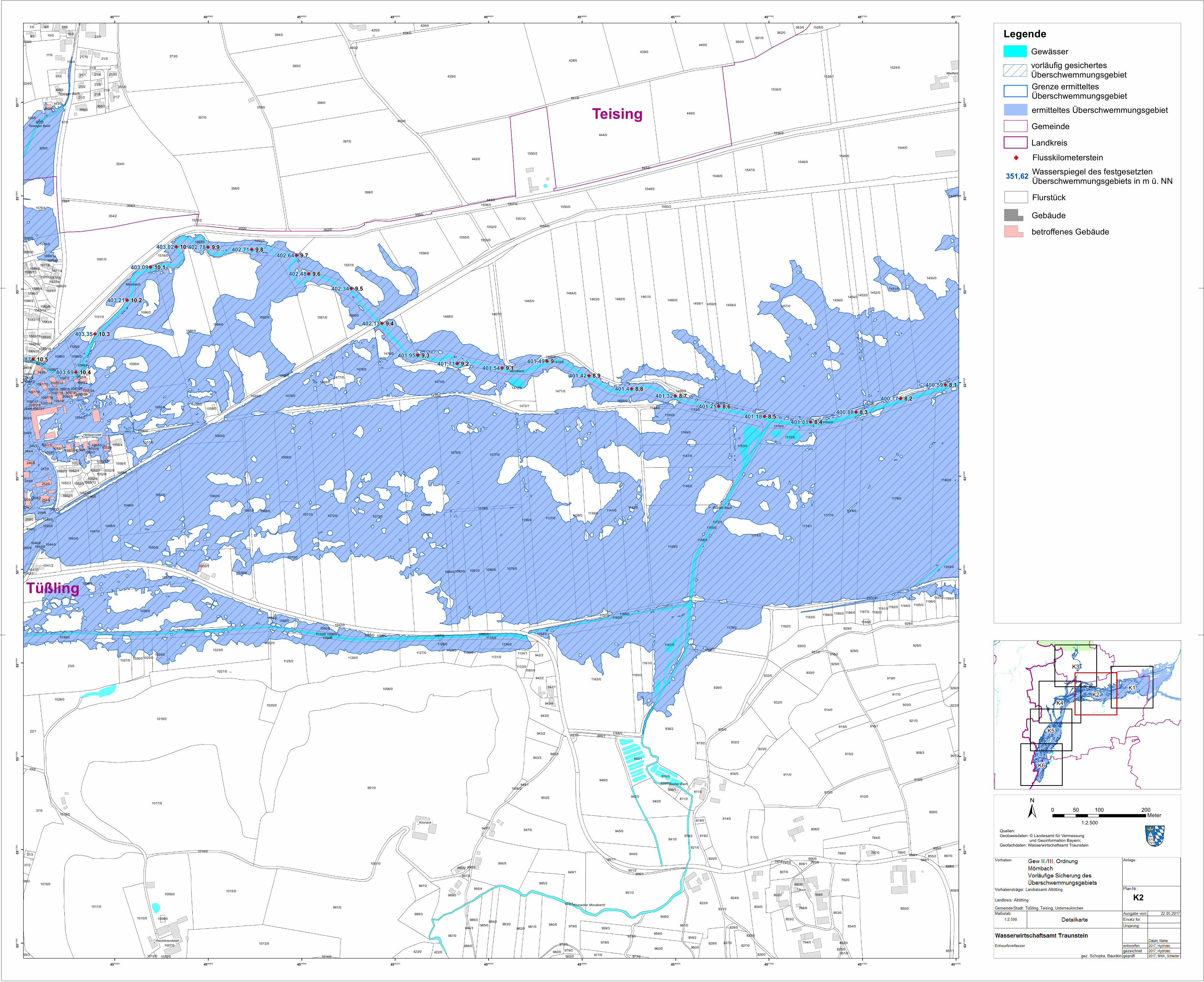
K1K2
K3
K6
K5
K4
±Quellen:Geobasisdaten: © Landesamt für Vermessung und Geoinformation Bayern; Geofachdaten: Wasserwirtschaftsamt Traunstein
1:2.500
0 100 20050Meter
"/
"/
"/
"/
"/
"/
"/
"/
"/
"/
"/
"/
"/
"/
"/
"/
"/
"/"/"/
"/
"/
"/
"/
"/
991/0
1019/0
435/0
1457/0
1006/0
1179/0
1073/0
991/0
1017/0
1174/0
354/0
398/0
1524/0
444/0
855/0
1450/0
1410/0
357/0
1562/0
1035/0
1075/0
373/0
1530/0
1137/0
356/0
397/0
23/0
1163/0
1011/0
446/0
438/0
1465/0
1062/0
1072/0
442/0
1019/0
1544/0
395/0
1581/0
1458/0
1468/0
1456/01460/0
1068/0
936/0
1015/0
1557/0
911/0
1462/0
1177/0
808/0
936/2
1566/0
1451/0
946/0
1077/0
1145/0
951/3
1095/0
396/0
1508/0
439/0
1142/0
908/0
953/0
928/0
814/0
1013/0
1180/0
1141/0
1546/0
915/2
1054/0
908/3
1170/0
1071/0
1009/0
1593/2
1556/0
1464/0
1076/0
1139/0
914/0
1473/0
1459/1
1079/0
1126/0
910/0
1461/0
1146/0
1550/2
1061/0
1138/0
394/0
1549/0
947/0
37/0
1023/0
1564/0
1463/0
995/5
1452/0
1178/0
1036/0
17/0
932/2
440/0
354/2
794/0
932/0
919/0
1096/0
822/0
1453/0
1167/0
1055/0
949/1
1561/0
329/0
1476/0
1149/0
22/1
1081/0
1174/1
1028/0
945/0
1070/0
1479/0
1147/0
1576/4
1161/0
1471/0
1125/0
1050/0
804/0
941/0
983/0
921/0
1043/0
824/0
1021/0
1080/0
784/0
1039/3
929/0
23/0
789/0
1069/0
940/0
930/0
1555/0
980/0
1057/0
987/0
930/0
979/0
1548/0
1048/0
940/1
1082/0
960/0
1101/0
958/0
920/0
981/0
1010/0
1547/0
999/3
944/0
854/0
1550/0
1049/0
989/0
1153/0
1030/0
425/0
1551/0
1558/0
978/0
943/3
943/0
815/0
995/3
1063/0
917/0
1127/0
560/0
792/0
1469/0
1472/0
1039/0
1176/0
956/0
1047/0
1560/0
1175/0
802/0
985/0
859/0
1478/0
1182/0
1475/0
829/0
1552/0
325/0
1150/0
798/0
1131/0
21/7
943/2
561/0
942/2
1203/0
1449/0
1058/0
562/0
936/3
929/0
997/2
959/3
1092/0
922/0
959/0
1477/0
827/0
1020/0
1049/5
788/0821/0
21/0
934/0
986/0
928/0
1098/0
423/0
1027/0
1037/0
915/0
811/0
368/0
787/0
1134/0
1199/0
887/0
1152/0
1576/5
1024/0
1183/0
1130/0
1007/0
1026/0
17/1
1044/0
324/0
1195/0
807/0
853/0
932/0
1187/0
813/2
995/4
9/1
1129/0
1194/01196/0
933/0
252/0
1041/2
977/0
254/0
942/3
21/10
819/2
1578/0
246/0
803/2
1192/0
828/0
247/0
1577/7
15/0
1093/0
986/0
21/2
1058/4
21/3
21/1
343/0
820/0
243/0
12/07/0
348/3
1058/5
943/4
259/6
1528/0
1583/0
800/0
1185/0
1472/1
926/0942/1
1052/1
1588/12
811/2
426/0
959/2
936/1
249/0
929/0
21/6
9/0
1052/5
422/0
259/8
1186/0
21/5
1583/9
1088/0
1184/0
21/11
37/2
21/4
1577/8
1133/0
990/0
980/0
1134/1
259/0
1162/0
1583/6
1053/0
1586/2
1059/0
960/0
563/0
1052/4
368/1
1052/2
826/0
1097/3
565/0
855/2
343/2
786/0
1097/12
808/1
979/0
1097/13
37/3
1583/28
245/2
16/0
244/4
819/0
1097/2
1042/0
1136/0
1507/0
1459/01454/0
57/0
1049/3 1470/0
1165/0
935/0
1466/0
979/3
951/1
441/0
668/1
400/0
1084/0
1032/0
1554/0
1171/0
1155/0
1001/0
1018/0
1411/0
1528/1
1144/0
445/0
982/0
931/2
984/0
1157/0
378/0
1467/0
1169/0
1582/0
1033/0
1172/0
1056/0
1067/0
1094/0
797/5
1156/0
1025/0
944/1916/0
1159/0
810/0
255/6
434/0
354/3
1135/0
1545/0
1164/0
939/0
1097/0
1040/3
355/0
1586/4
21/9
916/1
951/2
942/0
1565/0
1197/0
931/3
399/0
1534/0
1046/2
1052/0
352/0
1053/6
1099/0
1016/0
21/8
245/5
1553/0
1053/41053/91053/8
1160/0
1053/10
1078/0
1583/10
1191/0
946/1
1190/0
996/0
1040/0
1053/7
825/0
956/1
244/0
1083/0
1090/0
827/0
327/0
1052/9
1097/16
908/2
245/0
1577/41577/0
1052/8
240/8
38/3
1053/5
975/0
797/0
1052/3
409/0
1085/0
351/0
961/0
1006/2
119/4
38/3
1052/11
951/0
1052/7
1046/0
19/0
851/0
1460/2
1052/6
1098/1
852/0
1097/5
979/2
944/3
1588/0
255/2
1583/14
1577/6
1583/18
1053/3
1022/0
1097/26
974/0
443/0
1052/12
1097/15
1586/3
1052/10
997/4
1097/9
1097/241097/4
1042/1
440/2
1100/0
916/2
977/0
797/6
1583/37
1588/13
1097/14
1589/0
1041/0
907/2
1097/1
1097/11
1583/29
1563/0
244/2
1099/3
240/4
1583/16
825/0
1034/0
1014/0
1576/6
1012/0
1188/0
82/10
1045/0
82/0
886/0
1008/0
1058/6
947/1
1128/0
1575/2
857/1
338/0
1590/0
945/3
1089/0
1097/18
1577/5
244/61097/17
1097/27
259/5
1097/6
1097/21
1012/0
354/4
1087/0
908/1
Tüßling
Teising
Mörnbach
Mörnbach
Mörnbach
Bucher Bach
Bucher Bach
Kronacker Moosbachl
Teisinger Bach
Teisinger Bach
401,4
403,35
403,21
403,09
403,02 402,71402,64
402,48
402,34
402,13
401,95401,71 401,54
401,42
401,32
401,18401,01
400,88400,77
400,59
Buch
Kronack
Weitfeld
Heiligenstatt
Reichbrandstätt
10 9,9 9,89,7
9,6
9,5
9,4
9,39,2
8,98,8
8,5 8,38,2
8,1
10,3
10,2
10,1
403,87403,69
402,78
401,49
401,25
99,1
8,78,6
8,4
10,510,4
4545600
4545600
4545800
4545800
4546000
4546000
4546200
4546200
4546400
4546400
4546600
4546600
4546800
4546800
4547000
4547000
4547200
4547200
4547400
4547400
5341
000
5341
000
5341
200
5341
200
5341
400
5341
400
5341
600
5341
600
5341
800
5341
800
5342
000
5342
000
5342
200
5342
200
5342
400
5342
400
5342
600
5342
600
5342
800
5342
800
K2
LegendeGewässervorläufig gesichertesÜberschwemmungsgebiet
ermitteltes ÜberschwemmungsgebietGemeindeLandkreis
Grenze ermitteltesÜberschwemmungsgebiet
FlurstückGebäudebetroffenes Gebäude
351,62 Wasserspiegel des festgesetztenÜberschwemmungsgebiets in m ü. NN
"/ Flusskilometerstein