Embed Size (px)
Citation preview
Journal of Applied Geology, vol. 4(2), 2019, pp. 82–91DOI: http://dx.doi.org/10.22146/jag.53208
Total Sulfur and Ash Yield of Tanjung Formation Coal in Sekako, BaritoBasin, Central Kalimantan: Implication of Depositional Process
Beny Wiranata, Hendra Amijaya∗, Ferian Anggara, Agung Rizki Perdana, Oyinta FatmaIsnadiyati, and Deddy Nan Setya Putra Tanggara
Department of Geological Engineering, Faculty of Engineering, Universitas Gadjah Mada, Yogyakarta, Indonesia
ABSTRACT. Tanjung Formation is one of the major coal-bearing deposit in the Barito Basin,Central Kalimantan. The distribution of total sulfur and ash yield in coal is closely relatedto the depositional environment. This study was to determine the total sulfur and ashyield and the interpretation of the dynamics of depositional process. Coal seam A and Bgenerally have low to medium ash yield 2.82 to 9.23 (wt.%, db) and low total sulfur contentof <1 (wt.%, db), except for the 6PLY1 coal sample which has total sulfur content thatrelatively high at 1.55 (wt.%, db). Coal samples 5PLY1A, 5PLY1B, 5PLY3, 5PLY5, 6PLY2,6PLY4, 6PLY5, 6PLY7, and 6PLY9 which have low to medium ash yield and low totalsulfur content <1% (wt.%, db) are formed in the topogeneous mire (freshwater swamp) ina fluvial environment. The total sulfur content was interpreted to be derived mainly fromthe parent plant materials. Meanwhile, the 6PLY1 coal sample which has an ash yield of5.83 (wt.%, db) and total sulfur content of 1.55 (wt.%, db) formed in topogeneous mire inan environment that is invaded by sea water, and the total sulfur content were interpretedcoming from the parent plant materials and the effect of seawater invasion which is richin sulfate (SO4) compounds. It is also supported by the occurrence of syngenetic mineralcontent (framboidal pyrite) and epigenetic pyrite of 1.23 (vol.%).
Keywords: Barito Basin · Tanjung Formation · Ash · Total sulfur · Syngenetic pyrite.
1 INTRODUCTION
Coal is a sedimentary rock that is combustible,which is formed as a result of the lithificationprocess of plant residues deposited in swampenvironments and forming peat (Suarez-Ruizand Crelling, 2008). Kalimantan is one of theislands in Indonesia which is known as themain producer of coal resources. The BaritoBasin is one of the main coal-bearing depositsbasins which is generally spread in the easternpart of Kalimantan Island (Friederich and vanLeeuwen, 2017). In general, coal in the Basin inKalimantan is divided into two namely Paleo-gene and Neogen Coal (Friederich et al., 2016;Friederich and van Leeuwen, 2017).
∗Corresponding author: H. AMIJAYA, Depart-ment of Geological Engineering, Universitas GadjahMada. Jl. Grafika 2 Yogyakarta, Indonesia. E-mail:[email protected]
Eocene bituminous coal is spread in the sedi-mentary basin in the southeastern part of Kali-mantan Island (especially Barito Basin and Up-per Kutai sub-basin), and some in the westernpart of Kalimantan Island. Eocene bituminouscoal typically has low to the moderate ash yieldof lesser or equal to 10% in the Upper KutaiSub-Basin and reaches more than 15% in thesoutheastern part of Borneo, as well as withvarying sulfur content (Friederich et al., 2016;Friederich and van Leeuwen, 2017). Mean-while, Neogen coal generally has low ash andsulfur content. Characteristically, Neogen coalis formed in an ombrogenous peat mires. High–low volatile bituminous coal of Tanjung For-mation in Lemo, Central Kalimantan Provincehas low ash and total sulfur content (Amrullah,2009).
Mire is a wetland where the peat accumu-
2502-2822/ c© 2019 Journal of Applied Geology
TOTAL SULFUR AND ASH YIELD OF TANJUNG FORMATION COAL IN SEKAKO, BARITO BASIN
lated. It covers all the places where peat isformed, including swamp, bog, fen, moor,muskeg, and peatland (Taylor et al., 1998).Mire can be divided into topogenous mire(marsh, fen, swamps) and ombrogenous mire(raised bog). The formation of peat in topo-geneous mire is predominantly influenced byhigh groundwater levels, while ombrogenousmire (raised bog) is more affected by high rain-fall so that the groundwater table is below thepeat surface or peat-forming surface (Diessel,1992; Taylor et al., 1998). In interpreting peatpaleodepositional environments, distributionof ash yield and the composition of mineralmatters in coal are important parameters.
The distribution and variation of sulfur con-tent are closely related to the coal depositionenvironment (Diessel, 1992; Taylor et al., 1998;Chou, 2012). Sulfur contained in coal can bederived from the parent plant material and sul-fate (SO4) compounds in seawater at the time offlooding of the peat swamp. Coal with a sulfurcontent less than 1% is classified as low-sulfurcoal, while, coal which has a sulfur content of1% to <3% is classified as medium-sulfur coal,and coal which has a sulfur content of morethan 3% classified as high-sulfur coal (Chou,2012). The abundance of sulfur content in coalis strongly influenced by invasion or seawaterflooding during the process of peat accumula-tion and after precipitation (Diessel, 1992; Tay-lor et al., 1998; Chou, 2012).
Ash is an inorganic material or non-combustible residue material after the pro-cess of heating or burning coal (Miller, 2005;Thomas, 2002; Speight, 2005; Riddell and Han,2017). Ash yield is composed by various vari-ations of minerals contained in coal. Mineralsmatter contained in coal can be in form of de-trital minerals, plant-derived minerals, andauthigenic minerals (McCabe, 1984). The ashyield in coal generally varies from 5% to 40%(Oni and Ehinola, 2017). The distribution andvariation of ash yield in coal are greatly affectedby the depositional environment in which thecoal is formed. This is closely related to thefluctuations in the surface of the water in themire. The topogenous peat has high nutri-ent and inorganic materials (mineratrophic).Meanwhile, ombrogenous peat has a very low
nutrient supply and inorganic matters (Diessel,1992; Taylor et al., 1998; McCabe, 1984).
This study aims to analyze the ash and totalsulfur content in the Tanjung Formation coal inSekako, Central Kalimantan to interpreted thedynamics of the peat depositional process.
2 REGIONAL SETTING
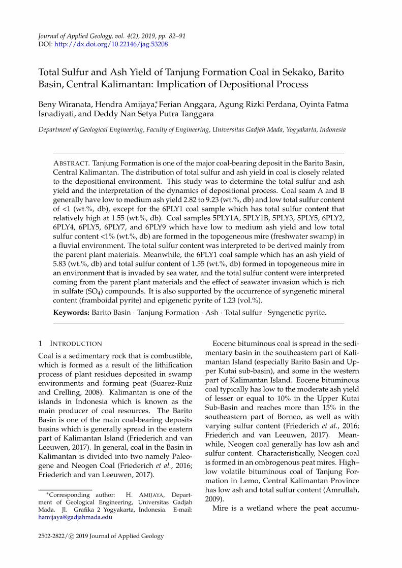
Barito Basin is located in southeastern part ofKalimantan Island (Satyana et al., 2001). Thebasin is bordered by Meratus Mountain in theeastern part, and western part is bordered bySchwaner Core. Adang Fault separated Bar-ito Basin from Kutai Basin in the northen part,and the basin extended to the Java Sea in theSouthern part (Satyana et al., 2001). The Bar-ito Basin was developed in Late Cretaceousto Palo/Eocene that facilitated by the collisionof Schwaner Core micro-continent and Peter-noster micro-continent (Satyana et al., 1999 inSatyana et al., 2001). At the beginning of theTertiary, extensional deformation occurs as a re-sult of oblique convergence which then causesrifting and subsidence. This rifting and subsi-dence process resulted in the formation of horstand graben with northwest-southeast pattern(Satyana and Silitonga, 1994). The rifting pro-cess is an accommodation space for the sedi-mentation of lacustrine and alluvial fans fromthe lower Tanjung Formation originating fromthe horst area. As a result of the transgres-sion process that took place in the early MiddleEocene, the rift sediment was changed to flu-viodeltaic and marine and was followed by de-position marine shales of the middle and upperTanjung Formation. The deposition of carbona-ceous material was continued until the earlyMiocene and ended when there was the addi-tion of clastic sediments from the west (Satyana,1996 in Darman and Sidi, 2000).
Synrift sequence in this basin is composedof Late Paleocene-Middle Eocene sedimentsnamely Lower Tanjung Formation. This for-mation is composed of sediments of sandstone,siltstone, shales, and conglomerates, with a thinlayer of coal. The lower part of this formationis composed of conglomerates and redbeds de-posits as part of the fan sediments. The upperpart of this sequence is composed of alluvialto lacustrine facies. This sediment character-izes as a major part of the rifting phase, which
Journal of Applied Geology 83
WIRANATA et al.
develops as a result of syndepositional fault-ing (Figure 1). The regional subsidence afterthe rifting phase in the basin during the Mid-dle Eocene – Early to Middle Miocene, duringthis time the sediment materials depositionoccurred from the upper of the lower part ofTanjung Formation, Upper Tanjung Formation,and Berai Formation, as the sediments from thetransgressive phase. The change in sedimentcharacteristics is very clear in the synrift andpostrift sequences. Based on well drilling data,the lower part facies and its thickness changesis local which indicates rift-infill, and the up-per sequences of the sediments are a regionaloccurrence which indicated that they are moreinfluenced by the irregularity horst and grabenterrain (Satyana and Silitonga, 1994).
3 METHODOLOGY
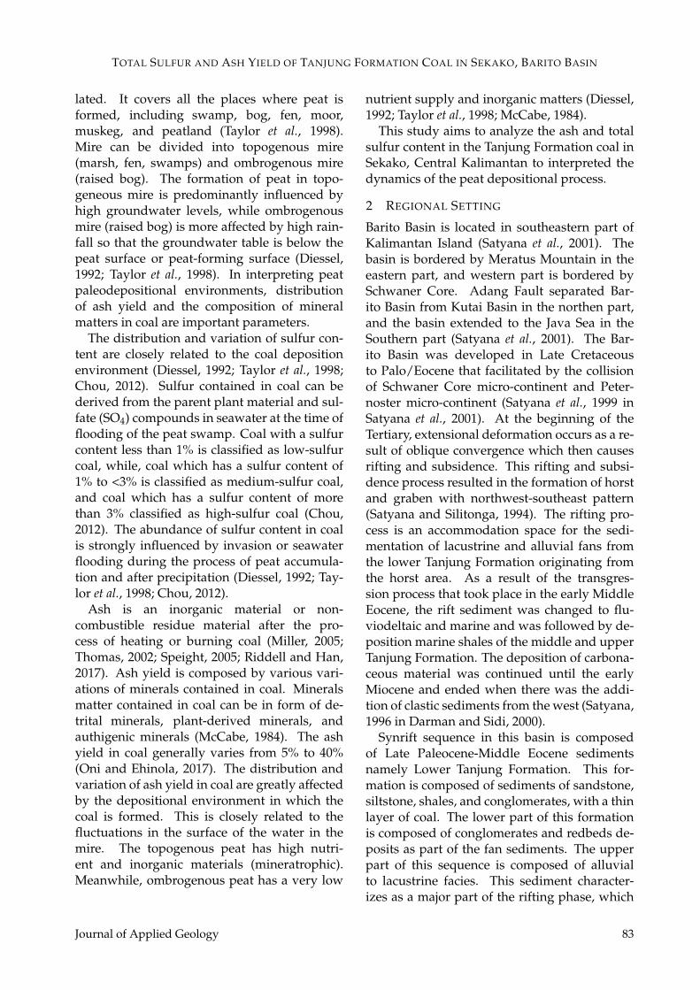
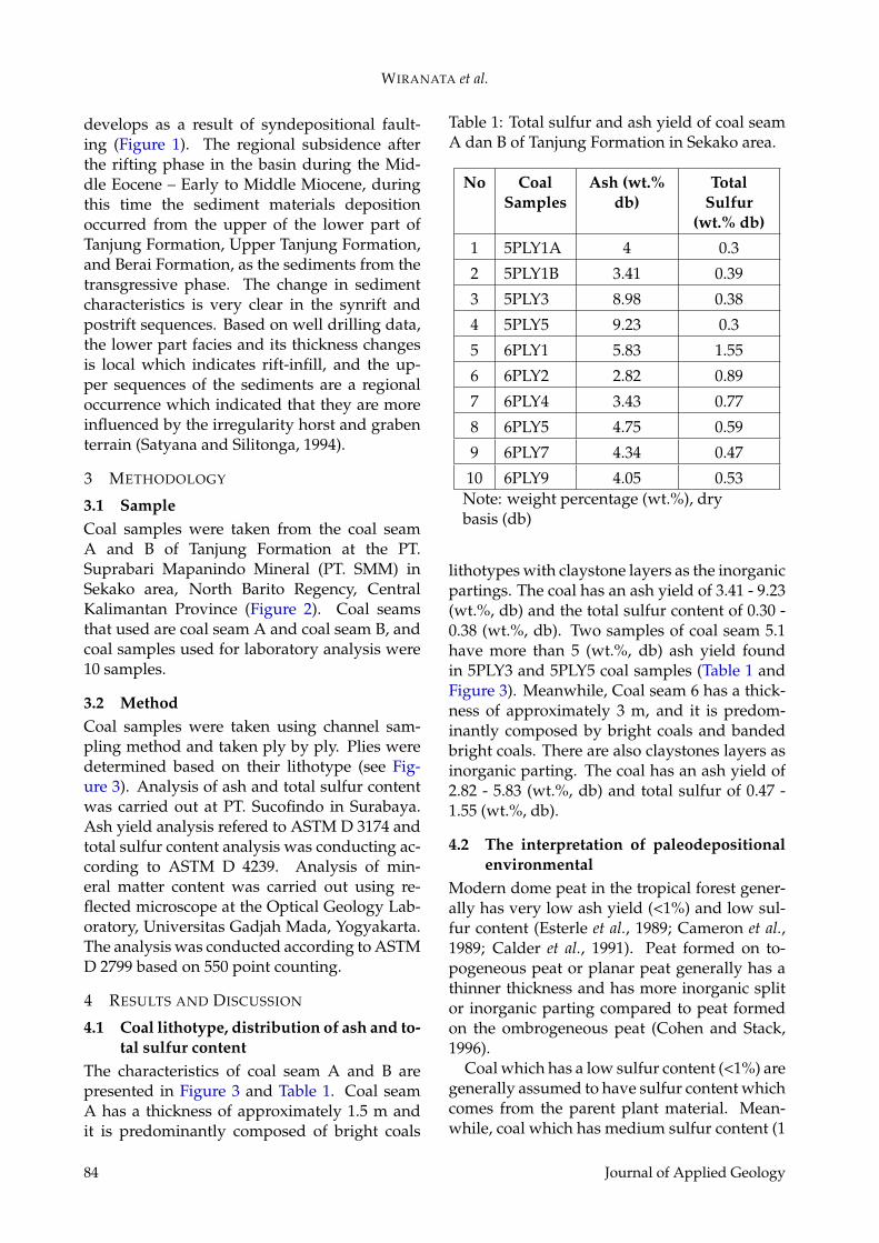
3.1 SampleCoal samples were taken from the coal seamA and B of Tanjung Formation at the PT.Suprabari Mapanindo Mineral (PT. SMM) inSekako area, North Barito Regency, CentralKalimantan Province (Figure 2). Coal seamsthat used are coal seam A and coal seam B, andcoal samples used for laboratory analysis were10 samples.
3.2 MethodCoal samples were taken using channel sam-pling method and taken ply by ply. Plies weredetermined based on their lithotype (see Fig-ure 3). Analysis of ash and total sulfur contentwas carried out at PT. Sucofindo in Surabaya.Ash yield analysis refered to ASTM D 3174 andtotal sulfur content analysis was conducting ac-cording to ASTM D 4239. Analysis of min-eral matter content was carried out using re-flected microscope at the Optical Geology Lab-oratory, Universitas Gadjah Mada, Yogyakarta.The analysis was conducted according to ASTMD 2799 based on 550 point counting.
4 RESULTS AND DISCUSSION
4.1 Coal lithotype, distribution of ash and to-tal sulfur content
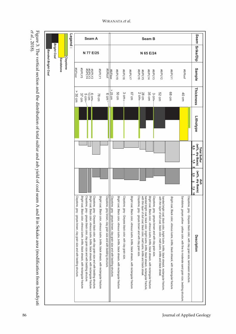
The characteristics of coal seam A and B arepresented in Figure 3 and Table 1. Coal seamA has a thickness of approximately 1.5 m andit is predominantly composed of bright coals
Table 1: Total sulfur and ash yield of coal seamA dan B of Tanjung Formation in Sekako area.
No CoalSamples
Ash (wt.%db)
TotalSulfur
(wt.% db)
1 5PLY1A 4 0.3
2 5PLY1B 3.41 0.39
3 5PLY3 8.98 0.38
4 5PLY5 9.23 0.3
5 6PLY1 5.83 1.55
6 6PLY2 2.82 0.89
7 6PLY4 3.43 0.77
8 6PLY5 4.75 0.59
9 6PLY7 4.34 0.47
10 6PLY9 4.05 0.53Note: weight percentage (wt.%), drybasis (db)
lithotypes with claystone layers as the inorganicpartings. The coal has an ash yield of 3.41 - 9.23(wt.%, db) and the total sulfur content of 0.30 -0.38 (wt.%, db). Two samples of coal seam 5.1have more than 5 (wt.%, db) ash yield foundin 5PLY3 and 5PLY5 coal samples (Table 1 andFigure 3). Meanwhile, Coal seam 6 has a thick-ness of approximately 3 m, and it is predom-inantly composed by bright coals and bandedbright coals. There are also claystones layers asinorganic parting. The coal has an ash yield of2.82 - 5.83 (wt.%, db) and total sulfur of 0.47 -1.55 (wt.%, db).
4.2 The interpretation of paleodepositionalenvironmental
Modern dome peat in the tropical forest gener-ally has very low ash yield (<1%) and low sul-fur content (Esterle et al., 1989; Cameron et al.,1989; Calder et al., 1991). Peat formed on to-pogeneous peat or planar peat generally has athinner thickness and has more inorganic splitor inorganic parting compared to peat formedon the ombrogeneous peat (Cohen and Stack,1996).
Coal which has a low sulfur content (<1%) aregenerally assumed to have sulfur content whichcomes from the parent plant material. Mean-while, coal which has medium sulfur content (1
84 Journal of Applied Geology
TOTAL SULFUR AND ASH YIELD OF TANJUNG FORMATION COAL IN SEKAKO, BARITO BASIN
. . ... . ......
...... ... .
. ..
. . . . . . . . . . . . . . . . .... . . . .. . . . .
.. . . . . . . . . . . . . . . . . . . ... . . . . . . . . . . . . . . . . . . .......
............................... . .. .. . .
. .. . ..... . . . . . . . . . . . . . . ................
............... .................. . ...............
.. . . . .. . .. . .. . .. . .. . .......
10
20
30
40
50
60
. . .. . .
. .. .
. ..
.
. .. . .. . .. . .....
.
FORMATION PLEOFACIESLITHOSTRATIGRAPHYSW NE
TECTONICSUMMARY
AGEMa
EPOCHP
ER
IOD
PALEOGENE
NEOGENE
WARUKIN
BERAI
TANJU
NG
BASEMENT
DAHOR
UPPER
MIDDLE
LOWER
UPPER
MIDDLE
LOWER
LOWER
UPPER
STAGE-4
STAGE-3
STAGE-2
STAGE-1ALLUVIAL FAN
FAN DELTAIC
LACUSTRINE
FLUVIAL DELTAIC
DELTA FRONT
NERITIC
PRODELTA
SHELF
PRODELTA
DELTA FRONT
DELTA PLAIN
LOWER
UPPER
DELTA PLAIN
DELTA FRONT
DELTA PLAIN
MO
LASSE
..
PLEISTOCENE
PLIO-CENE
MIO
CENE
OLIG
OCENE
EOCENE
PALEOCENE
E
L
E
M
L
E
L
E
M
L
EL
MERATUS OROGENY
REGIONALUPLIFT/INVERSION
PROTO-UPLIFT/INVERSION
STABLE
RAPIDBASIN
SUBSIDENCE
REGIONALSUBSIDENCE
LOCALIZEDSUBSIDENCE
RIFTING
Figure 1. The stratigraphic of the Barito Basin that showing the formation, paleofacies, and the tectonic episode (Satyana and Silitonga, 1994)Figure 1: The stratigraphic of the Barito Basin that showing the formation, paleofacies, and thetectonic episode (Satyana dan Silitonga, 1994).
Meters
0 15.000 30.000
Barito Utara Regency
S. Kapuas
S.B
arito
Mamput
Liangbulang
Tumbang Tuan
Pujon
Gunung Mas Regency
Kapuas Regency
Murung Raya Regency
Kec. Sepang
Kec. Kapuas Hulu
Kec, Montalat
Kec, Laung Tuhup
Kec. Rungan
Kec. Kapuas Tengah
Kec, Teweh Tengah
Tanah Siang District
Kec. Banama Tingang
Kec. Kurun
Kec. Timpah
Kec, Lahei
Kec, Permata Intan
Kec, Gunung Timang
Kec. Tewah
Kec. Mantangai
Kec, Murung
Sumber Barito District
Muara Teweh
Tumbang Tuan
Pujon
Dahian Tambuk
Tewah
Tangirang
Lawanguwang
Mantaak
Sungai Pinang
Jangkang
Kahukup
Bajuh
Muara Sepanjang
Panjung Katliang
Bakanon
Juking Sopan
Muara Untu
Buntok Kecil
Paring Lahung
Sikan
Benao
Muara Laung
Puruk Cahu
Dirung Silarung
TukungBondang
Muara TapuhMantiat PAri
Sekako Area
B
Sabah
Brunei
Sarawak
Schwaner Complex
Raj
ang-
Cro
cker
Com
plex
Kalimantan
Anticline Kasale
TarakanBasin
North BaritoBasin
Kutai Basin
South China Sea
Java sea
Karim
unjaw
a Arc
h
Bawean Arch
Bar
ito B
asin
Mer
atus
Com
ple
x
Asem-AsemBasin
PaternosterPlatform
0 150
kilometers
300
Paternoster Fault
110 E 115 E 120 E
5 N
5 S
0
Sulawesi
South BaritoBasin
Figure 2: a. Physiography of Kalimantan Island and the study area location showed on the red rectangle, and b. Study area location map showed by red rectangle (midification from Witt et al., 2012 and administrative map is from ) bnpb.go.id
Figure 2: a. Physiography of Kalimantan Island and the study area location showed on the redrectangle, and b. Study area location map that showed by red rectangle (modification from Witts etal., 2012 and administrative map is from bnpb.go.id).
Journal of Applied Geology 85
WIRANATA et al.
Seam
Srik
e/D
ipT
hic
kn
ess
Lith
oty
pe
Seam A Seam B
N 77 E/25 N 65 E/24
Sa
mp
le
#5/F
loor
#5/P
LY5
#5/P
LY3
#5/P
LY1
#5/R
oof
#5/P
LY2
#5/P
LY4
#6/R
oof
#6/P
LY1
#6/P
LY2
#6/P
LY3
#6/P
LY4
#6/P
LY5
#6/P
LY6
#6/P
LY7
#6/P
LY8
#6/P
LY9
#6/F
loor
Ban
ded
Brig
ht C
oal
Brig
ht C
oal
Cla
ysto
ne
Leg
en
d :
40
cm
68
cm
52
cm
3 cm
35
cm
28 cm2
cm
67 cm
3 cm
6 cm
50 cm
> 2
5 cm
78 cm
4 cm
13 cm5
cm3
7 cm
> 3
0 cm
San
dsto
ne
2,5
57,5
10
Ash
(wt%
, dry
Basis
)
0,5
11,5
2
To
tal S
ulfu
r(w
t%, d
ry B
asis
)D
escriptio
n
Claystone, grey - G
reyess black color, with clay grain size, lam
inasion structure.
Bright coal, B
lack color, vitreous lustre, brittle, black streack, with rectangular fracture
banded bright coal, black color, bright lustre, brittle, black streack, rectangular fracture, w
ith thin layer of dull coal, black color, matt lustre, brittle and black streak
Claystone, grey - greyes brow
n and with clay grain size.
Sandstone, greyes yellow
- yellow color, w
ith fine to moderate sand grain size, bedding structure.
Bright coal, B
lack color, vitreous lustre, brittle, black streack, with rectangular fracture
banded bright coal, black color, bright lustre, brittle, black streack, rectangular fracture, w
ith thin layer of dull coal, black color, matt lustre, brittle and black streak
Claystone, grey - greyes brow
n and with clay grain size.
Bright coal, B
lack color, vitreous lustre, brittle, black streack, with rectangular fracture
Claystone, grey - G
reyess black color, with clay grain size.
Bright coal, B
lack color, vitreous lustre, brittle, black streack, with rectangular fracture
Claystone, grey - greyes brow
n, clay grain size and with bedding structure.
Claystone, grey brow
n, clay grain size and with bedding structure.
Bright coal, B
lack color, vitreous lustre, brittle, black streack, with rectangular fracture
Claystone, grey - G
reyess black color, with clay grain size and w
ith bedding structure.
Bright coal, B
lack color, vitreous lustre, brittle, black streack, with rectangular fracture
Claystone, grey - greyes black color, clay grain size and w
ith bedding structure.
Bright coal, B
lack color, vitreous lustre, brittle, black streack, with rectangular fracture
Claystone, grey - greyes brow
n, clay grain size and with bedding structure.
Fig
ure 3
. The v
ertical section an
d th
e distribution of total sulfur and ash yield of coal seam A
and B in S
ekako area (modifi
cation from Isnadiyati
et al., 2018)
Figure3:T
heverticalsection
andthe
distributionoftotalsulfur
andash
yieldofcoalseam
Aand
Bin
Sekakoarea
(modification
fromIsnadiyati
etal.,2018).
86 Journal of Applied Geology
TOTAL SULFUR AND ASH YIELD OF TANJUNG FORMATION COAL IN SEKAKO, BARITO BASIN
to <3%) and high sulfur content equal or morethan 3%, the sulfur content comes from the par-ent plant material and comes from the influ-ence of seawater invasion which is rich in com-pound content sulfate (SO4). In various cases,coal with low sulfur content (<1%) is generallyformed in fluvial environments and coal whichhas a high sulfur content formed in the envi-ronment is affected by the presence of seawaterinvasion (Chou, 2012).
Widodo et al. (2010) studied the coal of Pu-lau Balang Formation in Sebulu and Central Bu-sang in the Kutai Basin have high ash and sulfurcontent, and also high pyrite mineral content.Pyrite minerals are generally syngenetic andepigenetic pyrite and interpreted to be formedin the topogeneous mire. Meanwhile, the Em-balut coal from the Balikpapan Formation haslower sulfur content of <1% and very low pyriteminerals interpreted to be formed in the ombro-geneous mire.
Based on the coal lithotype characteristics,the coal seam A and B of Tanjung Formationin Sekako is interpreted to form in the telmaticwet forest paleomire swamp (Isnadiyati et al.,2018). Coal seam A has low to moderate ashyield 3.41–9.23 (wt.%, db) and low total sul-fur content <1%. This coal seam is interpretedto be formed in the topogenous mire (miner-atrophic) which has a high water table and isrich in nutrient or inorganic material content.The high water level makes the peat alwaysflooded, and facilitates detrital mineral sedi-ment material transported into the mire wherecoal is formed by water or wind. Inorganic ma-terial or mineral matter contained in coal notonly comes from detrital minerals but can alsobe formed from plant-derived minerals and au-thigenic minerals (McCabe, 1984).
However, even though coal seam A is de-posited and formed on topogenous mire whichis always inundated, the coal has a low total sul-fur content of <1% (wt.%, db). This shows thatcoal seam A is formed and deposited on fresh-water peat swamp and there is no invasion orflooding of seawater. The sulfur content con-tained in coal can be interpreted from an or-ganic material or the parent plant material orsulfur containing mineral authigenetically.
Coal seam B of Tanjung Formation in Sekakoarea has moderate – high ash yield, which
ranges from 2.82 to 5.83 (wt.%, db). Meanwhile,the coal has a total sulfur content of generally<1 (wt.%, db), except for the coal sample 6PLY1which has medium sulfur total content (mod-erate) which is 1.55 (wt.%, db). The coal is in-terpreted to be formed in topogenous materialwhich is rich in nutrient content and inorganicmaterials. The mire always flooded with highwater levels so that detrital minerals or min-eral matter enters the mire which is facilitatedby wind or water media.
To the upward position (6PLY9, 6PLY7, PLY5,6PLY4, and 6PLY2), it is interpreted that theywere formed in the topogenous mire which is inthe freshwater telmatic wet forest swamp. Thismay cause moderate to high ash yield of coal.The coal is probably formed without invasionor seawater flooding so it has a low total sulfurcontent of <1% (wt.%, db). The low sulfur con-tent is interpreted to be formed from the parentplant material. Low sulfur content is probablyalso an indication that the coal was formed inthe fluvial associated subenvironment. Duringthe last deposition phase of the banded brightcoals (6PLY2) level increased which cause themire was invaded or flooded by sea water. Atthe same time, the peat precursor of bright coallithotype (6PLY1) was formed. The 6PLY1 coalsample has relatively high ash and total sulfurcontent compared to other samples (5.83 wt.%,db and 1.55 wt.%, db).
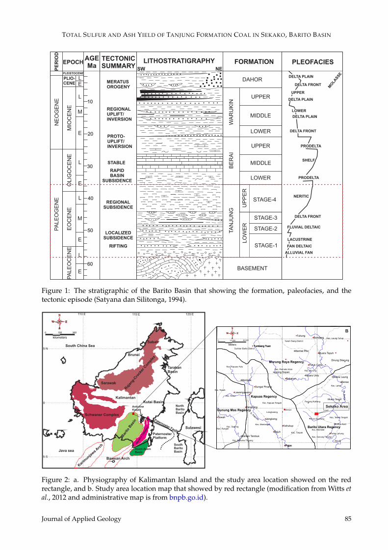
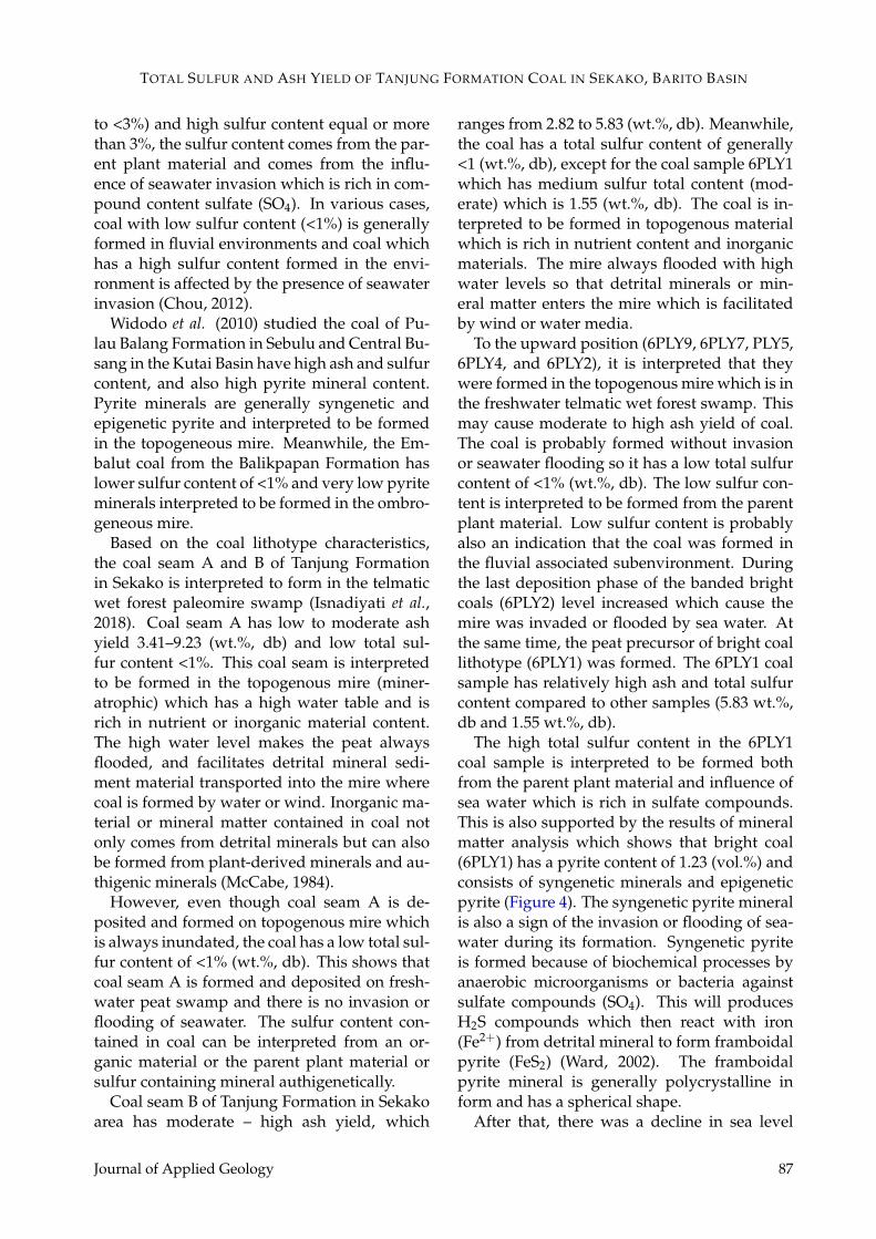
The high total sulfur content in the 6PLY1coal sample is interpreted to be formed bothfrom the parent plant material and influence ofsea water which is rich in sulfate compounds.This is also supported by the results of mineralmatter analysis which shows that bright coal(6PLY1) has a pyrite content of 1.23 (vol.%) andconsists of syngenetic minerals and epigeneticpyrite (Figure 4). The syngenetic pyrite mineralis also a sign of the invasion or flooding of sea-water during its formation. Syngenetic pyriteis formed because of biochemical processes byanaerobic microorganisms or bacteria againstsulfate compounds (SO4). This will producesH2S compounds which then react with iron(Fe2+) from detrital mineral to form framboidalpyrite (FeS2) (Ward, 2002). The framboidalpyrite mineral is generally polycrystalline inform and has a spherical shape.
After that, there was a decline in sea level
Journal of Applied Geology 87
WIRANATA et al.
S-pirit
E-Pirit
a
E-Pirit
b
E-Pirit
E-Pirit
cd
Scale
: 100 u
m
Collotelinite
Collotelinite
Collotelinite
Collotelinite
Scale
: 100 u
m
Scale
: 100 u
mS
ca
le : 1
00
um
Fig
ure 4
: a-b
. Sy
ng
enetic p
yrite (S
-py
rite) or fram
bo
idal pyrite an
d epig
enetic p
yrite (E-pyrite) in 6P
LY
1 coal sample, and c-d
. epigenetic pyrite (E
-pyrite) in
6P
LY
2 and
6P
LY
7 co
al samp
les Figure
4:a-b.Syngenetic
pyrite(S-pyrite)or
framboidalpyrite
andepigenetic
pyrite(E-pyrite)in
6PLY1
coalsample,and
c-d.epigenetic
pyrite(E-pyrite)in
6PLY2
and6PLY
7coalsam
ples.
88 Journal of Applied Geology
TOTAL SULFUR AND ASH YIELD OF TANJUNG FORMATION COAL IN SEKAKO, BARITO BASIN
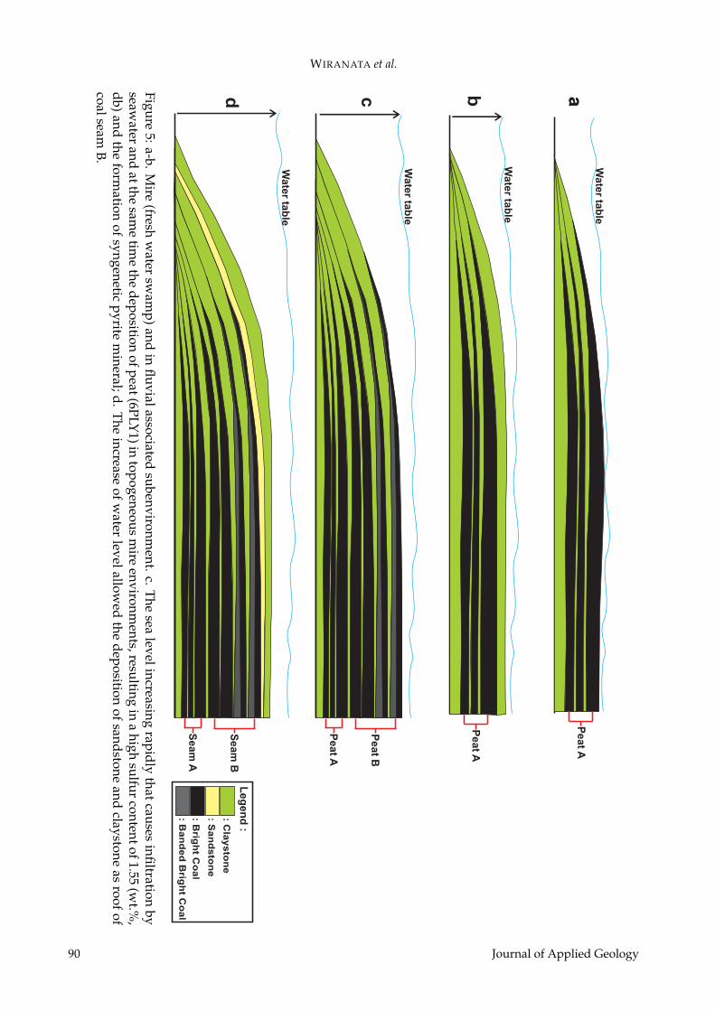
which caused change in the depositional envi-ronment to be more shallow. It is also char-acterized by the deposition of fine – mediumsandstones (Figure 3 and Figure 5) above brightbanded coal lithotypes (6PLY1). Furthermore,Isnadiyati et al., (2018) interpreted that one ofthe coal seam A in this area was formed by3 different paleopeat bodies. This successivedevelopment of peat are characterized by thepresence of two claystone layers as inorganicparting/inorganic split. Coal seam B was in-terpreted to be formed on 4 different paleopeatbodies which are characterized by the presenceof three claystone layers as the inorganic part-ing. It also shows that coal seam A and B areformed in inundated mire. This mire had highwater table and fluctuation occurred. The wa-ter table fluctuation caused deposition of inor-ganic parting which then followed by reinitia-tion of paleopeat. The summary of the dynamicchange of depositional condition during the for-mation of coal seam A and seam coal B is pre-sented in Figure 5.
5 CONCLUSION
Coal seam A and seam B of Tanjung Forma-tion in Sekako have thicknesses of 1.5 m and 3m respectively and is are predominantly com-posed by of bright coals and banded brightcoals. The coal generally has medium-high ashyield of 2.82 to 9.23 (wt.%, db) and low sulfurcontent <1 (wt.%, db), except for the 6PLY1 coalsample which has a high sulfur content whichis 1. 55 (wt.%, db). Coal samples (5PLY1A,5PLY1B, 5PLY3, 5PLY5, 6PLY2, 6PLY4, 6PLY5,6PLY7, and 6PLY9) which have medium to highash yield and low sulfur content <1% are in-terpreted to be formed in the topogenous mire(freshwater swamp) in a fluvial environment.The sulfur content is mainly related with theoriginal sulfur in the parent material and somesulfur containing authigenic mineral which wasformed during the peatification. Meanwhilethe 6PLY1 coal sample which has an ash yieldof 5.83 (wt.%, db) and total sulfur content >1% (wt.%, db) indicates a higher ash and sul-fur content which was contributed by the pres-ence of invasion or flooding by seawater richin sulfate (SO4) compounds in the topogeneousmire in limnic environments. Framboidal pyrite
minerals found within the coal samples are in-dicator of this phenomenon.
ACKNOWLEDGEMENTS
Authors thank PT. Suprabari Mapanindo Min-eral (PT. SMM) for permission to take coal sam-ples. This work was partly funded by the Min-istry of Research and Higher Education underPDUPT UGM.
REFERENCES
Amarullah, D. (2009) Suatu Pemikiran Untuk Me-manfaatkan Potensi Batubara Formasi Tanjung DiDaerah Lemo Kalimantan Tengah Sebagai Kokas.Kelompok Program Penelitian Energi Fosil, PusatSumber Daya Geologi, Bandung. v. 4. p. 1-11.
Amijaya, H., dan Litke, R. (2005) Microfacies andDepositional Environment of Tertiary TanjungEnim Low Rank Coal, South Sumatra Basin, In-donesia. International Journal of Coal Geology, v.6. p. 197-221.
ASTM (1977) Gaseous Fuel; Coal and Coke; Atmo-spheric Anlysis. American Society For Testingand Materials. v. 26. p. 429.
American Society for Testing and Materials (ASTM)D 3172 (2013) Standard Practice for ProximateAnalysis of Coal and Coke.
American Society for Testing and Materials (ASTM)D 4239 (2018. Standard Test Methods for Sulfurin the Analysis Sample of Coal and Coke UsingHigh-Temperature Tube Furnace Combustion.
Badan Nasional Penanggulangan Bencana (2009)Peta Pulau Kalimantan: geospasial.bnpb.go.id (di-akses pada Mei 2018).
Belkin, H.E., Tewalt, S.J., Hower, J.C., Stucker, J.D.,O’Keefe, J.M.K. (2009) Geochemistry and petrol-ogy of selected coal samples from Sumatra, Kali-mantan, Sulawesi and Papua, Indonesia, Interna-tional Journal of Coal Geology, v.77. p. 260-268.
Calder, J.H., Gibling, M.R., Mukhopadhyay, P.K.(1991) Peat Formation in A Westphalian B Pied-mont Setting, Cumberland Basin, Nova Scotia :Implications for The Maceral-Based Interpreta-tion of Rheotrophic and Raised Paleomires. Bul-letin Soc Geology. v. 162. No. 2. p. 283-298.
Cameron, C.C., Esterle, J.S., Palmer, C.A. (1989)The Geology, Botany, and Chemistry of SelectedPeat-Forming Environments From Temperate andTropical Latitudes. International Journal of CoalGeology, Elsevier. v. 12. p. 105-156.
Chou, C.L. (2012) Sulfur in Caols: A Review of Geo-chemistry and Origins. International Journal ofCoal Geology, v. 100. p. 1-13.
Cohen, A.D., and Stack, E.M. (1996) Some Observa-tions Regarding The Potential Effect of Domingof Tropical Peat Deposits On The Composition of
Journal of Applied Geology 89
WIRANATA et al.
ab acd
Pe
at A
Pe
at A
Pe
at A
Pe
at B
Se
am
A
Se
am
B
Wa
ter ta
ble
Wa
ter ta
ble
Wa
ter ta
ble
Wa
ter ta
ble
Leg
en
d :
: Cla
ys
ton
e
: Sa
nd
sto
ne
: Brig
ht C
oa
l
: Ba
nd
ed
Brig
ht C
oa
l
Fig
ure 5
: a-b
. Mire (fresh
water sw
amp) and
in fluvial asso
ciated subenvironm
ent; c. The sea level increasing rapidly that causes infiltartion by
seawater
and
at
the
same
time
the
dep
ositio
n
of
peat
(6P
LY
1)
in
top
og
eno
us
mire
env
iron
men
ts, resu
lting
in
a
hig
h
sulfur con
tent of 1.5
5 (wt%
,db) and
the fo
rmation of sy
ngenetic pyrite mineral; d
. The increase of w
ater level allowed the deposition
of
s
an
ds
to
ne
a
nd
c
la
ys
to
ne
a
s
ro
of
o
f
co
al
s
ea
m
B
Figure5:a-b.M
ire(fresh
water
swam
p)andin
fluvialassociatedsubenvironm
ent.c.Thesea
levelincreasingrapidly
thatcausesinfiltration
byseaw
aterand
atthesam
etim
ethe
depositionofpeat(6PLY
1)intopogeneous
mire
environments,resulting
ina
highsulfur
contentof1.55(w
t.%,
db)andthe
formation
ofsyngeneticpyrite
mineral;d.
Theincrease
ofw
aterlevelallow
edthe
depositionof
sandstoneand
claystoneas
roofof
coalseamB.
90 Journal of Applied Geology
TOTAL SULFUR AND ASH YIELD OF TANJUNG FORMATION COAL IN SEKAKO, BARITO BASIN
Coal Beds. International Journal of Coal Geol-ogy,elsevier. v. 29. p. 39-65.
Darman, H., Sidi, F.H. (2000) An Outline of The Ge-ology of Indonesia. Ikatan Ahli Geologi Indone-sia, Jakarta, 254 p.
Diessel, C.F.K. (1992) Coal-Bearing DepositionalSystem. Thompson Press (India) Ltd., New Delhi.679 p.
Esterle, J.S., Ferm, J.C., Yiu-Liong, T. (1989) A Testfor The Analogy of Tropical Domed Peat DepositsTo “Dilling Up” Sequence in Coal Beds – Prelimi-nary Results. Organic Geochemistry. v. 14. No. 3.p. 333-342.
Friederich, M.C., Moore, T.M., Flores, R.M. (2016) ARegional Review And New Insights Into SE AsianCenozoic Coal-Bearing Sediments: Why Does In-donesia Have Such Extensive Coal Deposits?. In-ternational Journal of Coal Geology, v. 166. p. 2-35.
Friederich, M.C., dan van Leeuwen, T. (2017) A Re-view of The History of Coal Exploration, Discov-ery and Production in Indonesia: The Interplay ofLegal Framework, Coal Geology and ExplorationStrategy. International Journal of Coal Geology, v.178, p. 56-73.
Isnadiyati, O.F., Wiranata, B., Perdana, A.R., Tang-gara, D.N.S.P., Amijaya, H., (2018) IterpretasiStacked Mire Sequence Berdasarkan LitotipePada Batubara Coking Formasi Tanjung DiDaerah Sekako, Kalimantan Tengah. SeminarNasional Kebumian, Yogyakarta. v. 11, p. 31.
Lamberson, M.N., Bustin, R.M., Kalkreuth, W.(1991) Lithotype (maceral) Composition andVariation As Correlated With Paleo-WetlandEnvironments, Gates Formation, NortheasternBritish Columbia, Canada. International Journalof Coal Geology, v. 18. p. 87-124.
McCabe, P.J. (1984) Depositional Environments ofCoal and Coal-Bearing Strata. The InternationalAssociation of Sedimentologists, v. 7. p. 13-42.
Oni, O.S., dan Ehinola, A.O., (2017) Estimation andAssesment of Free Swelling Index and Some Pet-rographic Properties From Chemical Analysis ofCoals Across River Niger. Petroleum and Coal. v.59 (30). p. 273-287.
Riddell, J., dan Han, T. (2017) Ash Chwmistry
Database For British Columbia Rocky MountainBituminous Coals. British Columbia GeologicalSurvey. v. 10. 15 p.
Ryemshak, S.A., dan Jauro, A. (2013) Proximateanalysis, Rheological Properties and Technologi-cal Application of Some Nigerian Coals. Interna-tional Journal of Industrial Chemistry (IJIC). v. 4.p. 1-7.
Satyana, A.H., and Silitonga, P.D. (1994) Tectonicreversal in East Barito Basin, South Kalimantan:consideration of the types of inversion structuresand petroleum system significance: in Proceed-ings of the IPA 23rd Annual Convention. p. 57-74.
Satyana, A.H., Eka, M.P., Imron, M. (2001) EoceneCoals of The Barito Basin, Southeast Kalimantan:Sequence Stratigraphic Framework and Potentialfor Sources of Oil : Berita Sedimentologi. v. 3. No.17. p. 1-15.
Soetrisno, Supriatna, S., Rustandi, E., Sanyoto, P.,Hasan, K. (1994) Geological Map of The BuntokQuadrangle, Kalimantan. Geological Researchand Development Center. 1 p.
Suarez Ruiz, I., Crelling, C.J. (2008) Applied CoalPetrology. Elsevier. 388 p.
Taylor, G.H., Teichmuller, M., Davis, A., Diessel,C.F.K., Littke, R., Robert, P. (1998) Organic Petrol-ogy. Gebruder Borntraeger, Stuttgart. 704 p.
Thomas, L. (2002) Coal Geology First Edition. JohnWiley & Sons, Ltd, West Sussex, United Kingdom.384 p.
Ward, C.R. (2002) Analysis and Significance of Min-eral Matter in Coal Seams. International Journalof Coal Geology, v. 50. p. 135-168.
Widodo, S., Oschmann, W., Bechtel, A., Sachsen-hofer, R.F., Anggayana, K., Puettmann, W. (2010)Distribution of Sulfur and Pyrite in Coal SeamsFrom Kutai Basin (East Kalimantan Indonesia):Implications For Paleoenvironmental Conditions.International Journal of Coal Geology, v. 81. p.151-162.
Witts, D., Hall, R., Nichols, G., dan Morley, R. (2012)A New Depositional and Provenance Model ForThe Tanjung Formation, Barito Basin, SE Kali-mantan, Indonesia. Journal of Asia Earth Science,v. 56. p. 77-104.
Journal of Applied Geology 91