Embed Size (px)
Citation preview
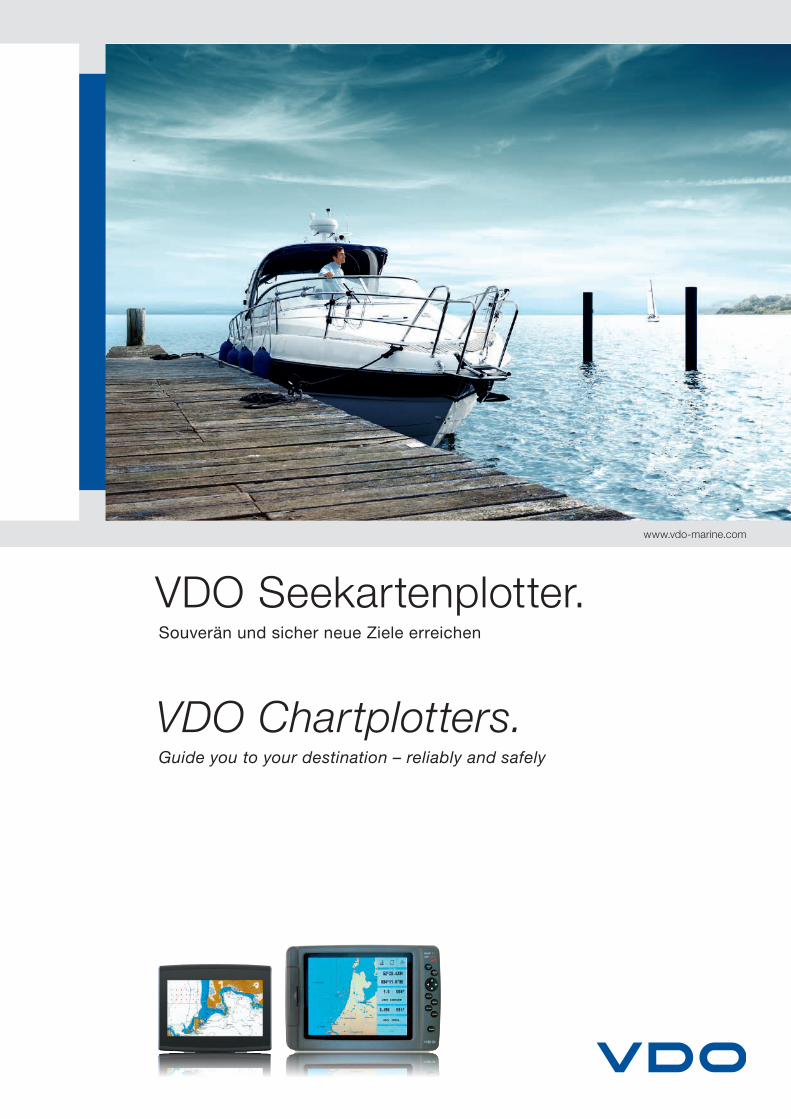
VDO Seekartenplotter.Souverän und sicher neue Ziele erreichen
VDO Chartplotters.Guide you to your destination – reliably and safely
www.vdo-marine.com
2
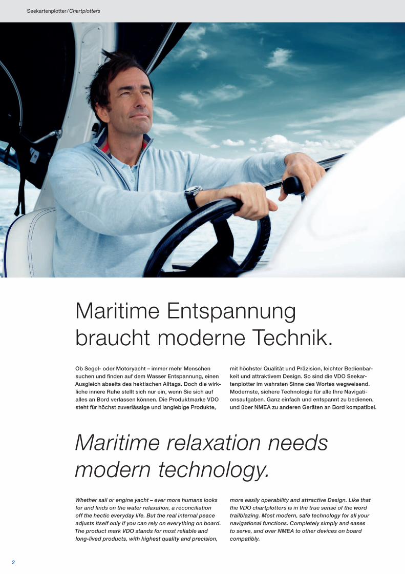
Maritime Entspannung braucht moderne Technik.Ob Segel- oder Motoryacht – immer mehr Menschen suchen und finden auf dem Wasser Entspannung, einen Ausgleich abseits des hektischen Alltags. Doch die wirk-liche innere Ruhe stellt sich nur ein, wenn Sie sich auf alles an Bord verlassen können. Die Produktmarke VDO steht für höchst zuverlässige und langlebige Produkte,
mit höchster Qualität und Präzision, leichter Bedienbar-keit und attraktivem Design. So sind die VDO Seekar-tenplotter im wahrsten Sinne des Wortes wegweisend. Modernste, sichere Technologie für alle Ihre Navigati-onsaufgaben. Ganz einfach und entspannt zu bedienen, und über NMEA zu anderen Geräten an Bord kompatibel.
Maritime relaxation needs modern technology.Whether sail or engine yacht – ever more humans looks for and finds on the water relaxation, a reconciliation off the hectic everyday life. But the real internal peace adjusts itself only if you can rely on everything on board. The product mark VDO stands for most reliable and long-lived products, with highest quality and precision,
more easily operability and attractive Design. Like that the VDO chartplotters is in the true sense of the word trailblazing. Most modern, safe technology for all your navigational functions. Completely simply and eases to serve, and over NMEA to other devices on board compatibly.
Seekartenplotter / Chartplotters
3
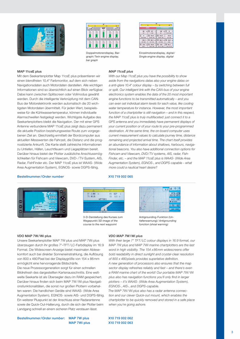
3-D-Darstellung des Kurses zum Wegepunkt / 3D image of the course to the next waypoint
Doppelmotorendisplay, Bar-graph / Twin engine display, bar graph
Antigrounding-Funktion (Un-tiefenwarnung) / Antigrounding function (shoal warning)
Einzelmotorendisplay, digital /Single engine display, digital
MAP 11csE plus Mit dem Seekartenplotter Map 11csE plus präsentieren wir einen blendfreien 10,4" Farbmonitor, auf dem sich neben Navigationsdaten auch Motordaten darstellen. Alle wichtigen Informationen sind so übersichtlich auf einen Blick verfügbar. Dabei kann zwischen Splitscreen oder Vollmodus gewählt werden. Durch die intelligente Verknüpfung mit dem CAN-Bus der Motorelektronik werden automatisch die 20 wich-tigsten Motordaten übermittelt. Für jeden Wert, beispiels-weise für die Kühlwassertemperatur, können individuelle Alarmschwellen festgelegt werden. Wichtigste Aufgabe des Seekartenplotters bleibt die Navigation. Der mit einer GPS Antenne verbundene MAP 11csE plus zeigt dazu permanent die aktuelle Position beziehungsweise Route zum vorgege-benen Ziel an. Gleichzeitig ermittelt der Bordcomputer aus aktuellen Messwerten die Fahrzeit, die Distanz und die prog-nostizierte Ankunft. Die Karte stellt zahlreiche Informationen zu Untiefen, Häfen, Leuchtfeuern und Liegeplätzen bereit.Darüber hinaus bietet der Plotter zusätzliche Anschlussmög-lichkeiten für Fishcam und Viewcam, DVD- / TV-System, AIS, Radar, FishFinder etc. Der MAP 11csE plus ist WAAS- (Wide Area Augmentation System), EGNOS- sowie DGPS-fähig.
MAP 11csE plus With our Map 11csE plus you have the possibility to show aside from the navigations datas also your engine datas on a anti-glare 10.4" colour display – by switching between full or split. Our intelligent link with the CAN-bus of your engine electronics system enables the data of the 20 most important engine functions to be transmitted automatically – and you can even set individual alarm levels for each value, like cooling water temperature for instance. However, the most important function of a chartplotter is still navigation – and in this respect, the MAP 11csE plus is truly multifaceted: just connect it to a GPS antenna and you immediately have permanent displays of your current position or of your route to your pre-programmed destination. At the same time, the on-board computer uses current measurement values to calculate journey time, distance remaining and projected arrival time. The chart itself provides an abundance of information about shallows, harbours, naviga-tional beacons. You also have additional connection options for Fishcam and Viewcam, DVD / TV systems, AIS, radar, Fish-Finder, etc. – and the MAP 11csE plus is WAAS- (Wide Area Augmentation System), EGNOS-, and DGPS-capable – what more could a nautical heart desire?
Bestellnummer / Order number X10 719 002 065
VDO MAP 7W / Wi plus Unsere Seekartenplotter MAP 7W plus und MAP 7Wi plus überzeugen durch ihr großes 7"–TFT / LC-Farbdisplay im 16:9 Format. Die Widescreen-Anzeige bietet maximalen Ablese-komfort auch bei direkter Sonneneinstrahlung, die Auflösung von 800 x 480 Pixel bei der Displaygröße von 154 x 86 mm ermöglicht eine hervorragende Bildschärfe. Die neue Prozessorgeneration sorgt für einen schnellen Bildrefresh des dargestellten Kartenausschnitts. Eine welt-weite Seekarte ist als Übersegler dazu im RAM gespeichert. Darüber hinaus finden sich beim MAP 7W / Wi plus Navigati-onsfunktionalitäten, die sonst nur großen Plottern vorbehal-ten waren: Die handlichen Geräte sind WAAS- (Wide Area Augmentation System), EGNOS- sowie AIS- und DGPS-fähig. Ein weiterer Pluspunkt ist der Anschluss einer Radarantenne sowie die Quick-Out-Halterung, durch die sich der Plotter beim Landgang schnell an einem sicheren Platz verstauen lässt.
VDO MAP 7W / Wi plus With their large 7" TFT / LC colour displays in 16:9 format, our MAP 7W plus and MAP 7Wi marine chartplotters are the last word in high visibility. The 154 x 86 mm widescreens offer bold readability in direct sunlight and crystal-clear resolution of 800 x 480 pixels provides superlative definition. A new generation of processors also ensures that the map sector display refreshes reliably and fast – and there‘s even a RAM marine chart of the world! Our portable MAP 7W / Wi plus also has navigation functions you’ll only find in larger plotters – it’s WAAS- (Wide Area Augmentation System), EGNOS-, AIS-, and DGPS- capable. The MAP 7W / Wi plus also has a radar antenna connec-tion and our clever Quick-out mount, which enables the chartplotter to be quickly removed and stored in a safe place when you‘re going ashore.
Bestellnummer / Order number: MAP 7W plus X10 719 002 062 MAP 7Wi plus X10 719 002 063
4
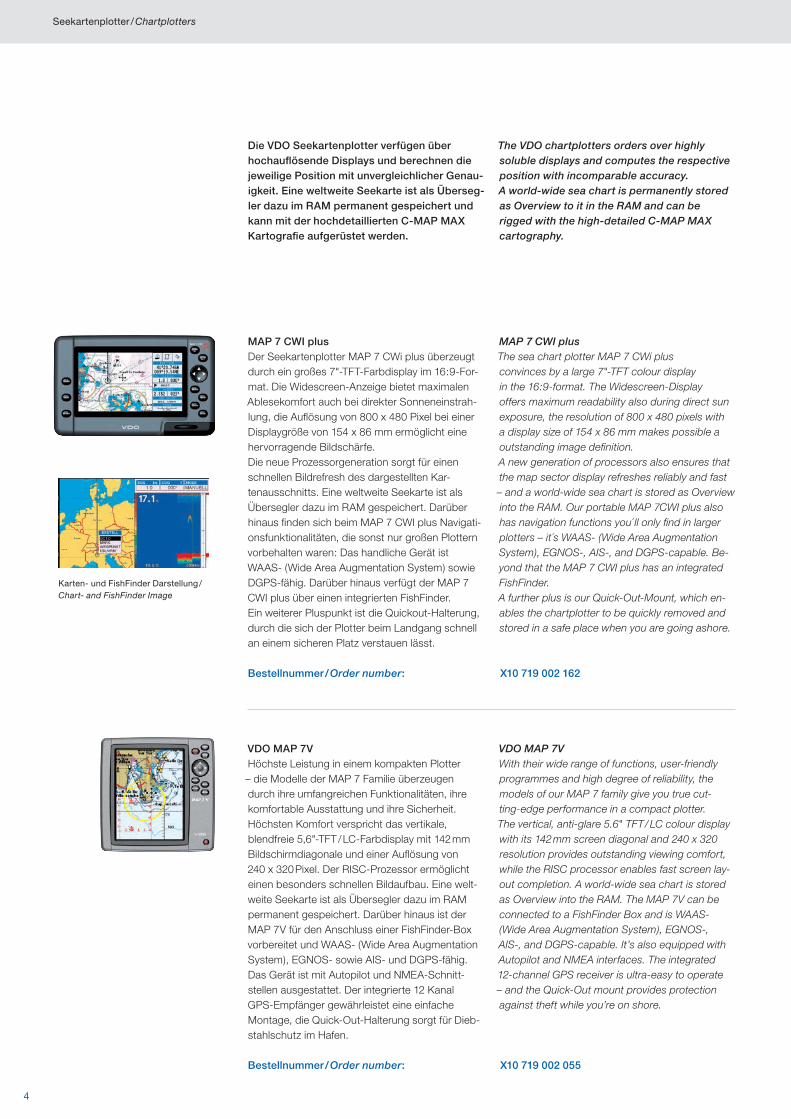
Die VDO Seekartenplotter verfügen über hochauflösende Displays und berechnen die jeweilige Position mit unvergleichlicher Genau-igkeit. Eine weltweite Seekarte ist als Überseg-ler dazu im RAM permanent gespeichert und kann mit der hochdetaillierten C-MAP MAX Kartografie aufgerüstet werden.
The VDO chartplotters orders over highly soluble displays and computes the respective position with incomparable accuracy. A world-wide sea chart is permanently stored as Overview to it in the RAM and can be rigged with the high-detailed C-MAP MAX cartography.
MAP 7 CWI plusDer Seekartenplotter MAP 7 CWi plus überzeugt durch ein großes 7"-TFT-Farbdisplay im 16:9-For-mat. Die Widescreen-Anzeige bietet maximalen Ablesekomfort auch bei direkter Sonneneinstrah-lung, die Auflösung von 800 x 480 Pixel bei einer Displaygröße von 154 x 86 mm ermöglicht eine hervorragende Bildschärfe.Die neue Prozessorgeneration sorgt für einen schnellen Bildrefresh des dargestellten Kar-tenausschnitts. Eine weltweite Seekarte ist als Übersegler dazu im RAM gespeichert. Darüber hinaus finden sich beim MAP 7 CWI plus Navigati-onsfunktionalitäten, die sonst nur großen Plottern vorbehalten waren: Das handliche Gerät ist WAAS- (Wide Area Augmentation System) sowie DGPS-fähig. Darüber hinaus verfügt der MAP 7 CWI plus über einen integrierten FishFinder.Ein weiterer Pluspunkt ist die Quickout-Halterung, durch die sich der Plotter beim Landgang schnell an einem sicheren Platz verstauen lässt.
MAP 7 CWI plusThe sea chart plotter MAP 7 CWi plus convinces by a large 7"-TFT colour display in the 16:9-format. The Widescreen-Display offers maximum readability also during direct sun exposure, the resolution of 800 x 480 pixels with a display size of 154 x 86 mm makes possible a outstanding image definition.A new generation of processors also ensures that the map sector display refreshes reliably and fast – and a world-wide sea chart is stored as Overview into the RAM. Our portable MAP 7CWI plus also has navigation functions you´ ll only find in larger plotters – it´s WAAS- (Wide Area Augmentation System), EGNOS-, AIS-, and DGPS-capable. Be-yond that the MAP 7 CWI plus has an integrated FishFinder.A further plus is our Quick-Out-Mount, which en-ables the chartplotter to be quickly removed and stored in a safe place when you are going ashore.
Bestellnummer / Order number: X10 719 002 162
VDO MAP 7VHöchste Leistung in einem kompakten Plotter – die Modelle der MAP 7 Familie überzeugen durch ihre umfangreichen Funktionalitäten, ihre komfortable Ausstattung und ihre Sicherheit.Höchsten Komfort verspricht das vertikale, blendfreie 5,6"-TFT / LC-Farbdisplay mit 142 mm Bildschirmdiagonale und einer Auflösung von 240 x 320 Pixel. Der RISC- Prozessor ermöglicht einen besonders schnellen Bildaufbau. Eine welt-weite Seekarte ist als Übersegler dazu im RAM permanent gespeichert. Darüber hinaus ist der MAP 7V für den Anschluss einer FishFinder- Box vorbereitet und WAAS- (Wide Area Augmentation System), EGNOS- sowie AIS- und DGPS-fähig. Das Gerät ist mit Autopilot und NMEA-Schnitt-stellen ausgestattet. Der integrierte 12 Kanal GPS-Empfänger gewährleistet eine einfache Montage, die Quick-Out-Halterung sorgt für Dieb-stahlschutz im Hafen.
VDO MAP 7VWith their wide range of functions, user-friendly programmes and high degree of reliability, the models of our MAP 7 family give you true cut-ting-edge performance in a compact plotter.The vertical, anti-glare 5.6" TFT / LC colour display with its 142 mm screen diagonal and 240 x 320 resolution provides outstanding viewing comfort, while the RISC processor enables fast screen lay-out completion. A world-wide sea chart is stored as Overview into the RAM. The MAP 7V can be connected to a FishFinder Box and is WAAS- (Wide Area Augmentation System), EGNOS-, AIS-, and DGPS-capable. It’s also equipped with Autopilot and NMEA interfaces. The integrated 12-channel GPS receiver is ultra-easy to operate – and the Quick-Out mount provides protection against theft while you’re on shore.
Bestellnummer / Order number: X10 719 002 055
Karten- und FishFinder Darstellung / Chart- and FishFinder Image
Seekartenplotter / Chartplotters
5
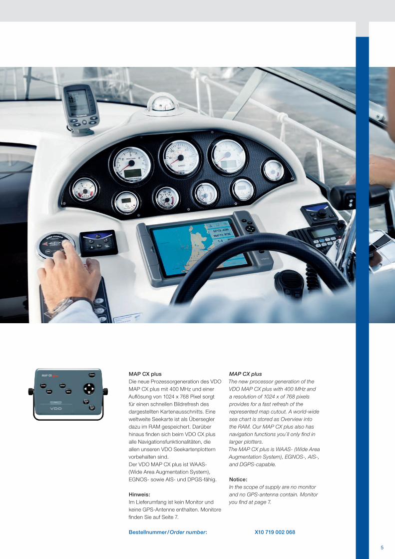
MAP CX plusDie neue Prozessorgeneration des VDO MAP CX plus mit 400 MHz und einer Auflösung von 1024 x 768 Pixel sorgt für einen schnellen Bildrefresh des dargestellten Kartenausschnitts. Eine weltweite Seekarte ist als Übersegler dazu im RAM gespeichert. Darüber hinaus finden sich beim VDO CX plus alle Navigationsfunktionalitäten, die allen unseren VDO Seekartenplottern vorbehalten sind.Der VDO MAP CX plus ist WAAS- (Wide Area Augmentation System), EGNOS- sowie AIS- und DPGS-fähig.
Hinweis: Im Lieferumfang ist kein Monitor und keine GPS-Antenne enthalten. Monitore finden Sie auf Seite 7.
MAP CX plusThe new processor generation of the VDO MAP CX plus with 400 MHz and a resolution of 1024 x of 768 pixels provides for a fast refresh of the represented map cutout. A world-wide sea chart is stored as Overview into the RAM. Our MAP CX plus also has navigation functions you´ ll only find in larger plotters.The MAP CX plus is WAAS- (Wide Area Augmentation System), EGNOS-, AIS-, and DGPS-capable.
Notice:In the scope of supply are no monitor and no GPS-antenna contain. Monitor you find at page 7.
Bestellnummer / Order number: X10 719 002 068
6
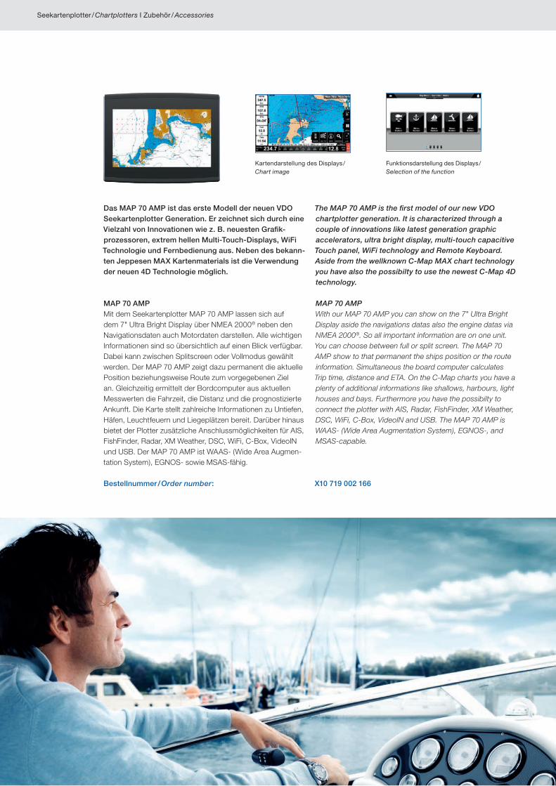
Das MAP 70 AMP ist das erste Modell der neuen VDO Seekartenplotter Generation. Er zeichnet sich durch eine Vielzahl von Innovationen wie z. B. neuesten Grafik-prozessoren, extrem hellen Multi-Touch-Displays, WiFi Technologie und Fernbedienung aus. Neben des bekann-ten Jeppesen MAX Kartenmaterials ist die Verwendung der neuen 4D Technologie möglich.
MAP 70 AMPMit dem Seekartenplotter MAP 70 AMP lassen sich auf dem 7" Ultra Bright Display über NMEA 2000® neben den Navigationsdaten auch Motordaten darstellen. Alle wichtigen Informationen sind so übersichtlich auf einen Blick verfügbar. Dabei kann zwischen Splitscreen oder Vollmodus gewählt werden. Der MAP 70 AMP zeigt dazu permanent die aktuelle Position beziehungsweise Route zum vorgegebenen Ziel an. Gleichzeitig ermittelt der Bordcomputer aus aktuellen Messwerten die Fahrzeit, die Distanz und die prognostizierte Ankunft. Die Karte stellt zahlreiche Informationen zu Untiefen, Häfen, Leuchtfeuern und Liegeplätzen bereit. Darüber hinaus bietet der Plotter zusätzliche Anschlussmöglichkeiten für AIS, FishFinder, Radar, XM Weather, DSC, WiFi, C-Box, VideoIN und USB. Der MAP 70 AMP ist WAAS- (Wide Area Augmen-tation System), EGNOS- sowie MSAS-fähig.
The MAP 70 AMP is the first model of our new VDO chartplotter generation. It is characterized through a couple of innovations like latest generation graphic accelerators, ultra bright display, multi-touch capacitive Touch panel, WiFi technology and Remote Keyboard. Aside from the wellknown C-Map MAX chart technology you have also the possibilty to use the newest C-Map 4D technology.
MAP 70 AMPWith our MAP 70 AMP you can show on the 7" Ultra Bright Display aside the navigations datas also the engine datas via NMEA 2000®. So all important information are on one unit. You can choose between full or split screen. The MAP 70 AMP show to that permanent the ships position or the route information. Simultaneous the board computer calculates Trip time, distance and ETA. On the C-Map charts you have a plenty of additional informations like shallows, harbours, light houses and bays. Furthermore you have the possibilty to connect the plotter with AIS, Radar, FishFinder, XM Weather, DSC, WiFi, C-Box, VideoIN and USB. The MAP 70 AMP is WAAS- (Wide Area Augmentation System), EGNOS-, and MSAS-capable.
Bestellnummer / Order number: X10 719 002 166
Kartendarstellung des Displays / Chart image
Funktionsdarstellung des Displays / Selection of the function
Seekartenplotter / Chartplotters I Zubehör / Accessories
7
Alles im Griff, mit intelligentem Zubehör.In Verbindung mit dem intelligenten Zubehör schöpfen Sie die Möglichkeiten voll aus, zum Beispiel mit unse-ren Marine Kameras, mit denen Sie an und unter Deck alles im Blick haben oder mit der Fishcam, die glasklare Farb-Unterwasserbilder vom Ankergrund auf den Bild-
schirm bringt. Weitere Anschlussmöglichkeiten wie Ra-dar, AIS, FishFinder, Sounder, Motordaten, DVD-TV-Sys-teme (modellabhängig) und vieles mehr sind bei unseren Seekartenplottern vorhanden und können über Vollbild bzw. Split screen angezeigt werden.
Totally in control – with intelligent accessories.In connection with the intelligent accessories you exhaust the possibilities fully, for example with our navy cameras, with those you at and under deck of everything in the view have or with the Fishcam, which bring highly transparent colour underwater pictures of the anchor reason on the screen. Further connection types such as
Radar, AIS, FishFinder, Sounder, Engine data, DVD TVsystems (model dependently), and much more besides are present with our chartplotters and can be indicated over frame and/or Split screen. All our accessories are designed to help you relax and enjoy your voyage – to the full.
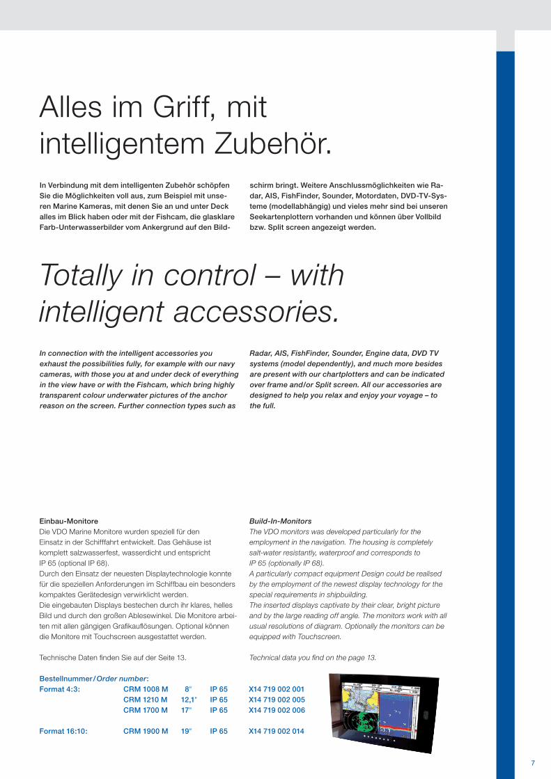
Einbau-MonitoreDie VDO Marine Monitore wurden speziell für den Einsatz in der Schifffahrt entwickelt. Das Gehäuse ist komplett salzwasserfest, wasserdicht und entspricht IP 65 (optional IP 68).Durch den Einsatz der neuesten Displaytechnologie konnte für die speziellen Anforderungen im Schiffbau ein besonders kompaktes Gerätedesign verwirklicht werden.Die eingebauten Displays bestechen durch ihr klares, helles Bild und durch den großen Ablesewinkel. Die Monitore arbei-ten mit allen gängigen Grafikauflösungen. Optional können die Monitore mit Touchscreen ausgestattet werden.
Technische Daten finden Sie auf der Seite 13.
Build-In-MonitorsThe VDO monitors was developed particularly for the employment in the navigation. The housing is completely salt-water resistantly, waterproof and corresponds to IP 65 (optionally IP 68).A particularly compact equipment Design could be realised by the employment of the newest display technology for the special requirements in shipbuilding.The inserted displays captivate by their clear, bright picture and by the large reading off angle. The monitors work with all usual resolutions of diagram. Optionally the monitors can be equipped with Touchscreen.
Technical data you find on the page 13.
Bestellnummer / Order number:Format 4:3: CRM 1008 M 8" IP 65 X14 719 002 001
CRM 1210 M 12,1" IP 65 X14 719 002 005 CRM 1700 M 17" IP 65 X14 719 002 006
Format 16:10: CRM 1900 M 19" IP 65 X14 719 002 014
8
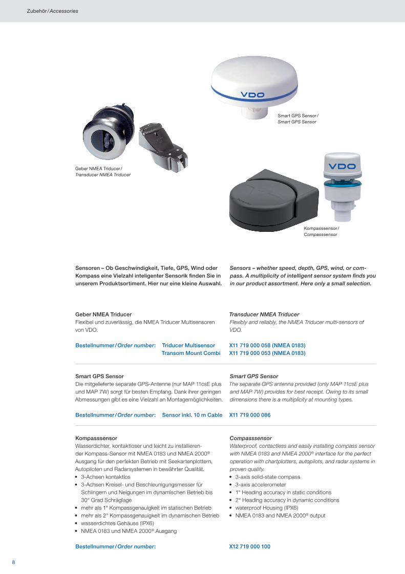
Geber NMEA Triducer /Transducer NMEA Triducer
Smart GPS Sensor /Smart GPS Sensor
Kompasssensor /Compasssensor
Smart GPS SensorDie mitgelieferte separate GPS-Antenne (nur MAP 11csE plus und MAP 7W) sorgt für besten Empfang. Dank ihrer geringen Abmessungen gibt es eine Vielzahl an Montagemöglichkeiten.
Smart GPS SensorThe separate GPS antenna provided (only MAP 11csE plus and MAP 7W) provides for best receipt. Owing to its small dimensions there is a multiplicity at mounting types.
Bestellnummer / Order number: Sensor inkl. 10 m Cable X11 719 000 086
Geber NMEA TriducerFlexibel und zuverlässig, die NMEA Triducer Multisensoren von VDO.
Transducer NMEA TriducerFlexibly and reliably, the NMEA Triducer multi-sensors of VDO.
Bestellnummer / Order number: Triducer Multisensor X11 719 000 058 (NMEA 0183) Transom Mount Combi X11 719 000 053 (NMEA 0183)
KompasssensorWasserdichter, kontaktloser und leicht zu installieren-der Kompass-Sensor mit NMEA 0183 und NMEA 2000® Ausgang für den perfekten Betrieb mit Seekartenplottern, Autopiloten und Radarsystemen in bewährter Qualität.• 3-Achsen kontaktlos• 3-Achsen Kreisel- und Beschleunigungsmesser für
Schlingern und Neigungen im dynamischen Betrieb bis 30° Grad Schräglage
• mehr als 1° Kompassgenauigkeit im statischen Betrieb• mehr als 2° Kompassgenauigkeit im dynamischen Betrieb• wasserdichtes Gehäuse (IPX6)• NMEA 0183 und NMEA 2000® Ausgang
CompasssensorWaterproof, contactless and easily installing compass sensor with NMEA 0183 and NMEA 2000® interface for the perfect operation with chartplotters, autopilots, and radar systems in proven quality.• 3-axis solid-state compass• 3-axis accelerometer• 1° Heading accuracy in static conditions• 2° Heading accuracy in dynamic conditions• waterproof Housing (IPX6)• NMEA 0183 and NMEA 2000® output
Bestellnummer / Order number: X12 719 000 100
Sensoren – Ob Geschwindigkeit, Tiefe, GPS, Wind oder Kompass eine Vielzahl inteligenter Sensorik finden Sie in unserem Produktsortiment. Hier nur eine kleine Auswahl.
Sensors – whether speed, depth, GPS, wind, or com-pass. A multiplicity of intelligent sensor system finds you in our product assortment. Here only a small selection.
Zubehör / Accessories
9
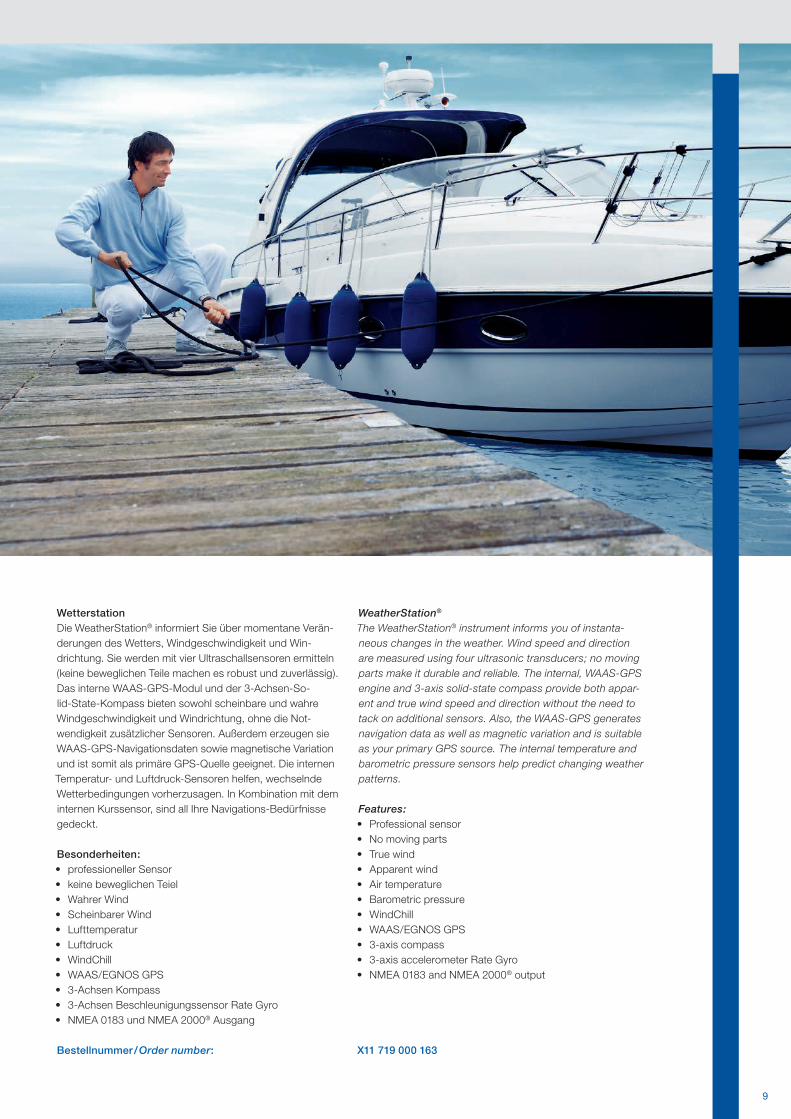
WetterstationDie WeatherStation® informiert Sie über momentane Verän-derungen des Wetters, Windgeschwindigkeit und Win-drichtung. Sie werden mit vier Ultraschallsensoren ermitteln (keine beweglichen Teile machen es robust und zuverlässig). Das interne WAAS-GPS-Modul und der 3-Achsen-So-lid-State-Kompass bieten sowohl scheinbare und wahre Windgeschwindigkeit und Windrichtung, ohne die Not-wendigkeit zusätzlicher Sensoren. Außerdem erzeugen sie WAAS-GPS-Navigationsdaten sowie magnetische Variation und ist somit als primäre GPS-Quelle geeignet. Die internen Temperatur- und Luftdruck-Sensoren helfen, wechselnde Wetterbedingungen vorherzusagen. In Kombination mit dem internen Kurssensor, sind all Ihre Navigations-Bedürfnisse gedeckt.
Besonderheiten:• professioneller Sensor• keine beweglichen Teiel• Wahrer Wind• Scheinbarer Wind• Lufttemperatur• Luftdruck• WindChill• WAAS/EGNOS GPS• 3-Achsen Kompass• 3-Achsen Beschleunigungssensor Rate Gyro• NMEA 0183 und NMEA 2000® Ausgang
WeatherStation®
The WeatherStation® instrument informs you of instanta-neous changes in the weather. Wind speed and direction are measured using four ultrasonic transducers; no moving parts make it durable and reliable. The internal, WAAS-GPS engine and 3-axis solid-state compass provide both appar-ent and true wind speed and direction without the need to tack on additional sensors. Also, the WAAS-GPS generates navigation data as well as magnetic variation and is suitable as your primary GPS source. The internal temperature and barometric pressure sensors help predict changing weather patterns.
Features:• Professional sensor• No moving parts • True wind• Apparent wind• Air temperature• Barometric pressure• WindChill• WAAS/EGNOS GPS• 3-axis compass• 3-axis accelerometer Rate Gyro• NMEA 0183 and NMEA 2000® output
Bestellnummer / Order number: X11 719 000 163
10
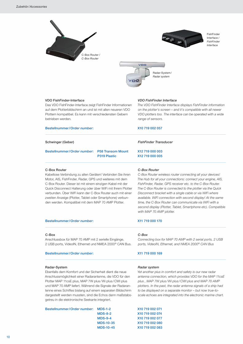
FishFinder Interface /FishFinder Interface
C-Box Router /C-Box Router
Radar-System /Radar system
VDO FishFinder-InterfaceDas VDO FishFinder-Interface zeigt FishFinder Informationen auf dem Plotterbildschirm an und ist mit allen neueren VDO Plottern kompatibel. Es kann mit verschiedensten Gebern betrieben werden.
VDO FishFinder InterfaceThe VDO FishFinder Interface displays FishFinder information on the plotter‘s screen – and it‘s compatible with all newer VDO plotters too. The interface can be operated with a wide range of sensors.
Bestellnummer / Order number: X10 719 002 057
Schwinger (Geber) FishFinder Transducer
Bestellnummer / Order number: P58 Transom Mount X12 719 000 003 P319 Plastic X12 719 000 005
C-Box RouterKabellose Verbindung zu allen Geräten! Verbinden Sie ihren Motor, AIS, FishFinder, Radar, GPS und weiteres mit dem C-Box Router. Dieser ist mit einem einzigen Kabel mit der Quick Disconnect Halterung oder über WiFi mit Ihrem Plotter verbunden. Über WiFi kann der C-Box Router auch mit einer zweiten Anzeige (Plotter, Tablet oder Smartphone) verbun-den werden. Kompatibel mit dem MAP 70 AMP Plotter.
C-Box Router C-Box Router wireless router connecting all your devices! The Hub for all your connections: connect your engine, AIS, FishFinder, Radar, GPS receiver etc. to the C-Box Router. The C-Box Router is connected to the plotter via the Quick Disconnect bracket with a single cable or via WiFi where available. WiFi connection with second display! At the same time, the C-Box Router can communicate via WiFi with a second display (Plotter, Tablet, Smartphone etc). Compatible with MAP 70 AMP plotter.
Bestellnummer / Order number: X11 719 000 170
C-BoxAnschlussbox für MAP 70 AMP mit 2 serielle Eingänge, 2 USB ports, VideoIN, Ethernet und NMEA 2000® CAN Bus.
C-BoxConnecting box for MAP 70 AMP with 2 serial ports, 2 USB ports, VideoIN, Ethernet, and NMEA 2000® CAN Bus
Bestellnummer / Order number: X11 719 000 169
Radar-SystemEbenfalls dem Komfort und der Sicherheit dient die neue Anschlussmöglichkeit einer Radarantenne, die VDO für den Plotter MAP 11csE plus, MAP 7W plus / Wi plus / CWI plus und MAP 70 AMP liefert. Während die Signale der Radaran-tenne eines Schiffes bislang auf einem separaten Bildschirm dargestellt werden mussten, sind die Echos dann maßstabs-getreu in die elektronische Seekarte integriert.
Radar systemYet another plus in comfort and safety is our new radar antenna connection, which provides VDO for the MAP 11csE plus , MAP 7W plus / Wi plus / CWI plus and MAP 70 AMP plotters. In the past, the radar antenna signals of a ship had to be displayed on a separate monitor – but now true-to-scale echoes are integrated into the electronic marine chart.
Bestellnummer / Order number: MDS-1-2 X10 719 002 071 MDS-8-2 X10 719 002 074 MDS-9-4 X10 719 002 077 MDS-10-35 X10 719 002 080 MDS-10-45 X10 719 002 083
Zubehör / Accessories
11
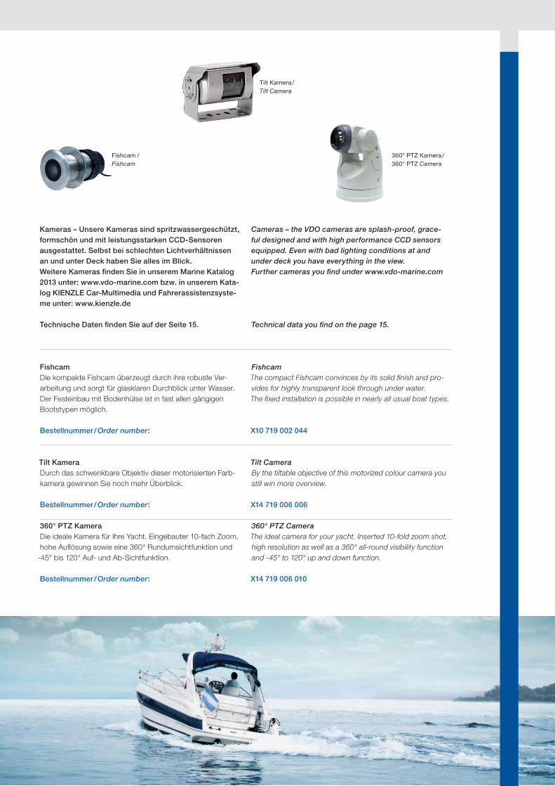
FishcamDie kompakte Fishcam überzeugt durch ihre robuste Ver-arbeitung und sorgt für glasklaren Durchblick unter Wasser. Der Festeinbau mit Bodenhülse ist in fast allen gängigen Bootstypen möglich.
FishcamThe compact Fishcam convinces by its solid finish and pro-vides for highly transparent look through under water. The fixed installation is possible in nearly all usual boat types.
Bestellnummer / Order number: X10 719 002 044
Tilt KameraDurch das schwenkbare Objektiv dieser motorisierten Farb-kamera gewinnen Sie noch mehr Überblick.
Tilt CameraBy the tiltable objective of this motorized colour camera you still win more overview.
Bestellnummer / Order number: X14 719 006 006
360° PTZ KameraDie ideale Kamera für Ihre Yacht. Eingebauter 10-fach Zoom, hohe Auflösung sowie eine 360° Rundumsichtfunktion und
-45° bis 120° Auf- und Ab-Sichtfunktion.
360° PTZ CameraThe ideal camera for your yacht. Inserted 10-fold zoom shot, high resolution as well as a 360° all-round visibility function and -45° to 120° up and down function.
Bestellnummer / Order number: X14 719 006 010
Kameras – Unsere Kameras sind spritzwassergeschützt, formschön und mit leistungsstarken CCD-Sensoren ausgestattet. Selbst bei schlechten Lichtverhältnissen an und unter Deck haben Sie alles im Blick.Weitere Kameras finden Sie in unserem Marine Katalog 2013 unter: www.vdo-marine.com bzw. in unserem Kata-log KIENZLE Car-Multimedia und Fahrerassistenzsyste-me unter: www.kienzle.de
Technische Daten finden Sie auf der Seite 15.
Cameras – the VDO cameras are splash-proof, grace-ful designed and with high performance CCD sensors equipped. Even with bad lighting conditions at and under deck you have everything in the view.Further cameras you find under www.vdo-marine.com
Technical data you find on the page 15.
360° PTZ Kamera /360° PTZ Camera
Tilt Kamera /Tilt Camera
Fishcam /Fishcam
12
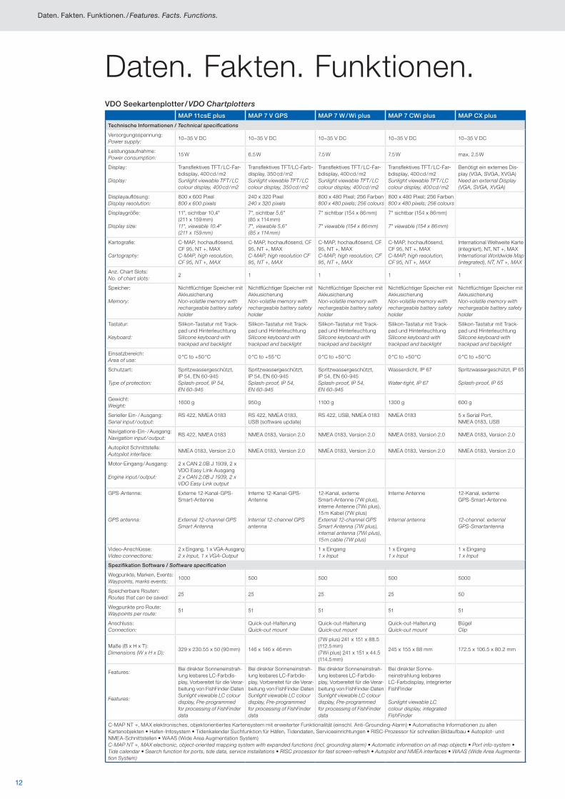
Daten. Fakten. Funktionen.VDO Seekartenplotter / VDO Chartplotters
MAP 11csE plus MAP 7 V GPS MAP 7 W / Wi plus MAP 7 CWi plus MAP CX plus
Technische Informationen / Technical specifications
Versorgungsspannung:Power supply:
10–35 V DC 10–35 V DC 10–35 V DC 10–35 V DC 10–35 V DC
Leistungsaufnahme:Power consumption:
15 W 6.5 W 7.5 W 7.5 W max. 2.5 W
Display:
Display:
Transflektives TFT / LC-Far-bdisplay, 400 cd / m2Sunlight viewable TFT / LC colour display, 400 cd / m2
Transflektives TFT/LC-Farb-display, 350 cd / m2Sunlight viewable TFT / LC colour display, 350 cd / m2
Transflektives TFT / LC-Far-bdisplay, 400 cd / m2Sunlight viewable TFT / LC colour display, 400 cd / m2
Transflektives TFT / LC-Far-bdisplay, 400 cd / m2Sunlight viewable TFT / LC colour display, 400 cd / m2
Benötigt ein externes Dis-play (VGA, SVGA, XVGA)Need an external Display (VGA, SVGA, XVGA)
Displayauflösung:Display resolution:
800 x 600 Pixel800 x 600 pixels
240 x 320 Pixel240 x 320 pixels
800 x 480 Pixel; 256 Farben800 x 480 pixels; 256 colours
800 x 480 Pixel; 256 Farben800 x 480 pixels; 256 colours
Displaygröße:
Display size:
11", sichtbar 10,4" (211 x 159 mm)11", viewable 10.4" (211 x 159 mm)
7", sichtbar 5,6" (85 x 114 mm)7", viewable 5,6" (85 x 114 mm)
7" sichtbar (154 x 86 mm)
7" viewable (154 x 86 mm)
7" sichtbar (154 x 86 mm)
7" viewable (154 x 86 mm)
Kartografie:
Cartography:
C-MAP, hochauflösend, CF 95, NT +, MAX C-MAP, high resolution, CF 95, NT +, MAX
C-MAP, hochauflösend, CF 95, NT +, MAXC-MAP, high resolution CF 95, NT +, MAX
C-MAP, hochauflösend, CF 95, NT +, MAXC-MAP, high resolution, CF 95, NT +, MAX
C-MAP, hochauflösend, CF 95, NT +, MAXC-MAP, high resolution, CF 95, NT +, MAX
International Weltweite Karte (integriert), NT, NT +, MAXInternational Worldwide Map (integrated), NT, NT +, MAX
Anz. Chart Slots:No. of chart slots:
2 1 1 1 1
Speicher:
Memory:
Nichtflüchtiger Speicher mit AkkusicherungNon-volatile memory with rechargeable battery safety holder
Nichtflüchtiger Speicher mit AkkusicherungNon-volatile memory with rechargeable battery safety holder
Nichtflüchtiger Speicher mit AkkusicherungNon-volatile memory with rechargeable battery safety holder
Nichtflüchtiger Speicher mit AkkusicherungNon-volatile memory with rechargeable battery safety holder
Nichtflüchtiger Speicher mit AkkusicherungNon-volatile memory with rechargeable battery safety holder
Tastatur:
Keyboard:
Silikon-Tastatur mit Track-pad und HinterleuchtungSilicone keyboard with trackpad and backlight
Silikon-Tastatur mit Track-pad und HinterleuchtungSilicone keyboard with trackpad and backlight
Silikon-Tastatur mit Track-pad und HinterleuchtungSilicone keyboard with trackpad and backlight
Silikon-Tastatur mit Track-pad und HinterleuchtungSilicone keyboard with trackpad and backlight
Silikon-Tastatur mit Track-pad und HinterleuchtungSilicone keyboard with trackpad and backlight
Einsatzbereich:Area of use:
0 °C to +50 °C 0 °C to +55 °C 0 °C to +50 °C 0 °C to +50 °C 0 °C to +50 °C
Schutzart:
Type of protection:
Spritzwassergeschützt, IP 54, EN 60-945Splash-proof, IP 54, EN 60-945
Spritzwassergeschützt, IP 54, EN 60-945Splash-proof, IP 54, EN 60-945
Spritzwassergeschützt, IP 54, EN 60-945Splash-proof, IP 54, EN 60-945
Wasserdicht, IP 67
Water-tight, IP 67
Spritzwassergeschützt, IP 65
Splash-proof, IP 65
Gewicht:Weight:
1600 g 950 g 1100 g 1300 g 600 g
Serieller Ein- / Ausgang:Serial input / output:
RS 422, NMEA 0183 RS 422, NMEA 0183, USB (software update)
RS 422, USB, NMEA 0183 NMEA 0183 5 x Serial Port, NMEA 0183, USB
Navigations-Ein- / Ausgang:Navigation input / output:
RS 422, NMEA 0183 NMEA 0183, Version 2.0 NMEA 0183, Version 2.0 NMEA 0183, Version 2.0 NMEA 0183, Version 2.0
Autopilot Schnittstelle:Autopilot interface:
NMEA 0183, Version 2.0 NMEA 0183, Version 2.0 NMEA 0183, Version 2.0 NMEA 0183, Version 2.0 NMEA 0183, Version 2.0
Motor-Eingang / Ausgang:
Engine input / output:
2 x CAN 2.0B J 1939, 2 x VDO Easy Link Ausgang2 x CAN 2.0B J 1939, 2 x VDO Easy Link output
GPS-Antenne:
GPS antenna:
Externe 12-Kanal-GPS- Smart-Antenne
External 12-channel GPS Smart Antenna
Interne 12-Kanal-GPS- Antenne
Internal 12-channel GPS antenna
12-Kanal, externe Smart-Antenne (7W plus), interne Antenne (7Wi plus), 15 m Kabel (7W plus)External 12-channel GPS Smart Antenna (7W plus), internal antenna (7Wi plus), 15 m cable (7W plus)
Interne Antenne
Internal antenna
12-Kanal, externe GPS-Smart-Antenne
12-channel. external GPS-Smartantenna
Video-Anschlüsse:Video connections:
2 x Eingang, 1 x VGA-Ausgang2 x Input, 1 x VGA-Output
1 x Eingang1 x Input
1 x Eingang1 x Input
1 x Eingang1 x Input
Spezifikation Software / Software specification
Wegpunkte, Marken, Events:Waypoints, marks events:
1000 500 500 500 5000
Speicherbare Routen:Routes that can be saved:
25 25 25 25 50
Wegpunkte pro Route:Waypoints per route:
51 51 51 51 51
Anschluss:Connection:
Quick-out-HalterungQuick-out mount
Quick-out-HalterungQuick-out mount
Quick-out-HalterungQuick-out mount
BügelClip
Maße (B x H x T):Dimensions (W x H x D):
329 x 230.55 x 50 (90 mm) 146 x 146 x 46 mm
(7W plus) 241 x 151 x 88.5 (112.5 mm)(7Wi plus) 241 x 151 x 44.5 (114.5 mm)
245 x 155 x 88 mm 172.5 x 106.5 x 80.2 mm
Features:
Features:
Bei direkter Sonneneinstrah-lung lesbares LC-Farbdis-play, Vorbereitet für die Verar-beitung von FishFinder-DatenSunlight viewable LC colour display, Pre-programmed for processing of FishFinder data
Bei direkter Sonneneinstrah-lung lesbares LC-Farbdis-play, Vorbereitet für die Verar-beitung von FishFinder-DatenSunlight viewable LC colour display, Pre-programmed for processing of FishFinder data
Bei direkter Sonneneinstrah-lung lesbares LC-Farbdis-play, Vorbereitet für die Verar-beitung von FishFinder-DatenSunlight viewable LC colour display, Pre-programmed for processing of FishFinder data
Bei direkter Sonne-neinstrahlung lesbares LC-Farbdisplay, integrierter FishFinder
Sunlight viewable LC colour display, integrated FishFinder
C-MAP NT +, MAX elektronisches, objektorientiertes Kartensystem mit erweiterter Funktionalität (einschl. Anti-Grounding-Alarm) • Automatische Informationen zu allen Karten objekten • Hafen-Infosystem • Tidenkalender Suchfunktion für Häfen, Tidendaten, Serviceeinrichtungen • RISC-Prozessor für schnellen Bildaufbau • Autopilot- und NMEA-Schnittstellen • WAAS (Wide Area Augmentation System)C-MAP NT +, MAX electronic, object-oriented mapping system with expanded functions (incl. grounding alarm) • Automatic information on all map objects • Port info-system • Tide calendar • Search function for ports, tide data, service installations • RISC processor for fast screen-refresh • Autopilot and NMEA interfaces • WAAS (Wide Area Augmenta-tion System)
Daten. Fakten. Funktionen. / Features. Facts. Functions.
13
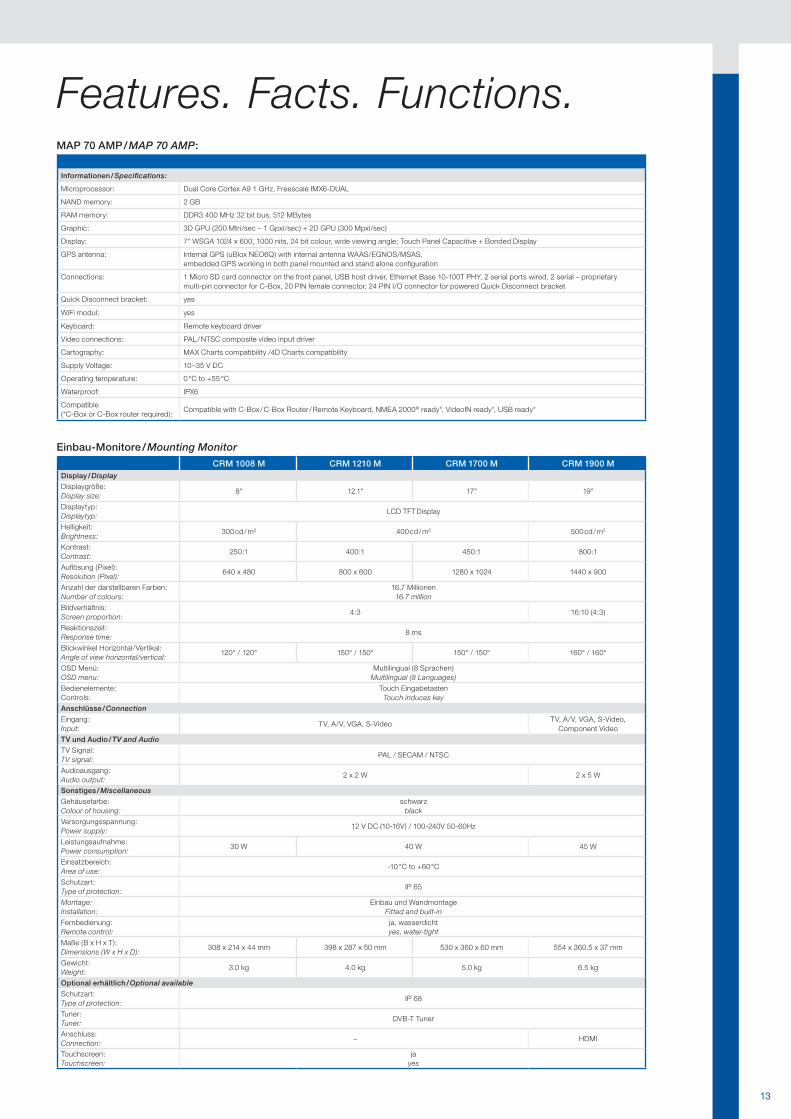
Einbau-Monitore / Mounting Monitor
CRM 1008 M CRM 1210 M CRM 1700 M CRM 1900 MDisplay / Display
Displaygröße:Display size:
8" 12.1" 17" 19"
Displaytyp:Displaytyp:
LCD TFT Display
Helligkeit:Brightness:
300 cd / m2 400 cd / m2 500 cd / m2
Kontrast:Contrast:
250:1 400:1 450:1 800:1
Auflösung (Pixel):Resolution (Pixel):
640 x 480 800 x 600 1280 x 1024 1440 x 900
Anzahl der darstellbaren Farben:Number of colours:
16,7 Millionen16.7 million
Bildverhältnis:Screen proportion:
4:3 16:10 (4:3)
Reaktionszeit:Response time:
8 ms
Blickwinkel Horizontal/Vertikal:Angle of view horizontal/vertical:
120° / 120° 150° / 150° 150° / 150° 160° / 160°
OSD Menü:OSD menu:
Multilingual (8 Sprachen)Multilingual (8 Languages)
Bedienelemente:Controls:
Touch EingabetastenTouch induces key
Anschlüsse / Connection
Eingang:Input:
TV, A/V, VGA, S-VideoTV, A/V, VGA, S-Video,
Component Video
TV und Audio / TV and Audio
TV Signal:TV signal:
PAL / SECAM / NTSC
Audioausgang:Audio output:
2 x 2 W 2 x 5 W
Sonstiges / Miscellaneous
Gehäusefarbe:Colour of housing:
schwarzblack
Versorgungsspannung:Power supply:
12 V DC (10-16V) / 100-240V 50-60Hz
Leistungsaufnahme:Power consumption:
30 W 40 W 45 W
Einsatzbereich:Area of use:
-10 °C to +60 °C
Schutzart:Type of protection:
IP 65
Montage: Installation:
Einbau und WandmontageFitted and built-in
Fernbedienung:Remote control:
ja, wasserdichtyes, water-tight
Maße (B x H x T):Dimensions (W x H x D):
308 x 214 x 44 mm 398 x 287 x 50 mm 530 x 360 x 60 mm 554 x 360.5 x 37 mm
Gewicht:Weight:
3.0 kg 4.0 kg 5.0 kg 6.5 kg
Optional erhältlich / Optional available
Schutzart:Type of protection:
IP 68
Tuner:Tuner:
DVB-T Tuner
Anschluss:Connection:
– HDMI
Touchscreen:Touchscreen:
jayes
Features. Facts. Functions.MAP 70 AMP / MAP 70 AMP:
Informationen / Specifications:
Microprocessor: Dual Core Cortex A9 1 GHz, Freescale IMX6-DUAL
NAND memory: 2 GB
RAM memory: DDR3 400 MHz 32 bit bus, 512 MBytes
Graphic: 3D GPU (200 Mtri/sec – 1 Gpxl/sec) + 2D GPU (300 Mpxl/sec)
Display: 7" WSGA 1024 x 600, 1000 nits, 24 bit colour, wide viewing angle; Touch Panel Capacitive + Bonded Display
GPS antenna: Internal GPS (uBlox NEO6Q) with internal antenna WAAS/EGNOS/MSAS, embedded GPS working in both panel mounted and stand alone configuration
Connections: 1 Micro SD card connector on the front panel, USB host driver, Ethernet Base 10-100T PHY, 2 serial ports wired, 2 serial – proprietary multi-pin connector for C-Box, 20 PIN female connector, 24 PIN I/O connector for powered Quick Disconnect bracket
Quick Disconnect bracket: yes
WiFi modul: yes
Keyboard: Remote keyboard driver
Video connections: PAL / NTSC composite video input driver
Cartography: MAX Charts compatibility /4D Charts compatibility
Supply Voltage: 10–35 V DC
Operating temperature: 0 °C to +55 °C
Waterproof: IPX6
Compatible(*C-Box or C-Box router required):
Compatible with C-Box / C-Box Router / Remote Keyboard, NMEA 2000® ready*, VideoIN ready*, USB ready*
14
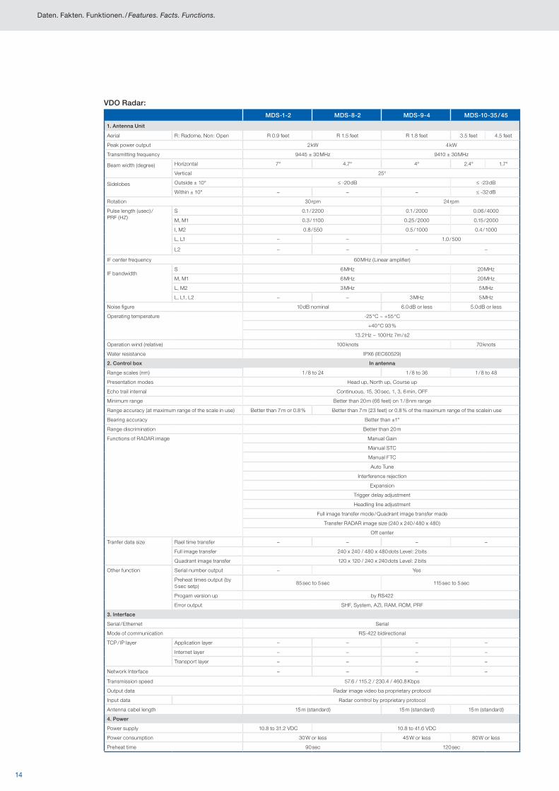
VDO Radar:
MDS-1-2 MDS-8-2 MDS-9-4 MDS-10-35 / 45
1. Antenna Unit
Aerial R: Radome, Non: Open R 0.9 feet R 1.5 feet R 1.8 feet 3.5 feet 4.5 feet
Peak power output 2 kW 4 kW
Transmitting frequency 9445 ± 30 MHz 9410 ± 30 MHz
Beam width (degree) Horizontal 7° 4.7° 4° 2.4° 1.7°
Vertical 25°
Sidelobes Outside ± 10° ≤ -20 dB ≤ -23 dB
Within ± 10° – – – ≤ -32 dB
Rotation 30 rpm 24 rpm
Pulse length (usec) / PRF (HZ)
S 0.1 / 2200 0.1 / 2000 0.06 / 4000
M, M1 0.3 / 1100 0.25 / 2000 0.15 / 2000
I, M2 0.8 / 550 0.5 / 1000 0.4 / 1000
L, L1 – – 1.0 / 500
L2 – – – –
IF center frequency 60 MHz (Linear amplifier)
IF bandwidthS 6 MHz 20 MHz
M, M1 6 MHz 20 MHz
L, M2 3 MHz 5 MHz
L, L1, L2 – – 3 MHz 5 MHz
Noise figure 10 dB nominal 6.0 dB or less 5.0 dB or less
Operating temperature -25 °C ~ +55 °C
+40 °C 93 %
13.2 Hz ~ 100 Hz 7m / s2
Operation wind (relative) 100 knots 70 knots
Water resistance IPX6 (IEC60529)
2. Control box In antenna
Range scales (nm) 1 / 8 to 24 1 / 8 to 36 1 / 8 to 48
Presentation modes Head up, North up, Course up
Echo trail internal Continuous, 15, 30 sec, 1, 3, 6 min, OFF
Minimum range Better than 20 m (66 feet) on 1 / 8 nm range
Range accuracy (at maximum range of the scale in use) Better than 7 m or 0.8 % Better than 7 m (23 feet) or 0.8 % of the maximum range of the scalein use
Bearing accuracy Better than ±1°
Range discrimination Better than 20 m
Functions of RADAR image Manual Gain
Manual STC
Manual FTC
Auto Tune
Interference rejection
Expansion
Trigger delay adjustment
Headling line adjustment
Full image transfer mode / Quadrant image transfer made
Transfer RADAR image size (240 x 240 / 480 x 480)
Off center
Tranfer data size Rael time transfer – – – –
Full image transfer 240 x 240 / 480 x 480 dots Level: 2 bits
Quadrant image transfer 120 x 120 / 240 x 240 dots Level: 2 bits
Other function Serial number output – Yes
Preheat times output (by 5 sec setp)
85 sec to 5 sec 115 sec to 5 sec
Progam version up by RS422
Error output SHF, System, AZI, RAM, ROM, PRF
3. Interface
Serial / Ethernet Serial
Mode of communication RS-422 bidirectional
TCP / IP layer Application layer – – – –
Internet layer – – – –
Transport layer – – – –
Network Interface – – – –
Transmission speed 57.6 / 115.2 / 230.4 / 460.8 Kbps
Output data Radar image video ba proprietary protocol
Input data Radar comtrol by proprietary protocol
Antenna cabel length 15 m (standard) 15 m (standard) 15 m (standard)
4. Power
Power supply 10.8 to 31.2 VDC 10.8 to 41.6 VDC
Power consumption 30 W or less 45 W or less 80 W or less
Preheat time 90 sec 120 sec
Daten. Fakten. Funktionen. / Features. Facts. Functions.
15
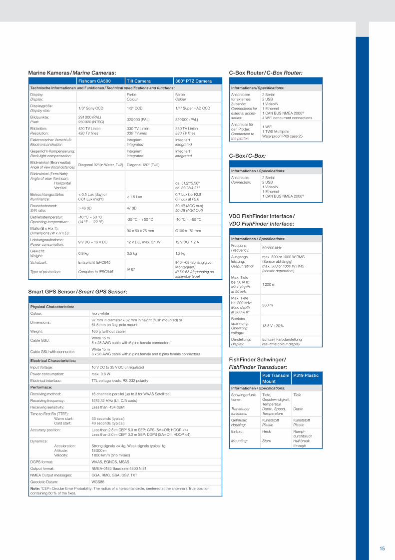
VDO FishFinder Interface /VDO FishFinder Interface:
Informationen / Specifications:
Frequenz:Frequency:
50/200 kHz
Ausgangs-leistung:Output rating:
max. 500 or 1000 W RMS(Sensor abhängig)max. 500 or 1000 W RMS(sensor-dependent)
Max. Tiefe bei 50 kHz:Max. depth at 50 kHz:
1 200 m
Max. Tiefe bei 200 kHz:Max. depth at 200 kHz:
360 m
Betriebs-spannung:Operating voltage:
13.8 V ±20 %
Darstellung:Display:
Echtzeit Farbdarstellungreal-time colour display
FishFinder Schwinger /FishFinder Transducer:
P58 Transom Mount
P319 Plastic
Informationen / Specifications:
Schwingerfunk-tionen:
Transducer funktions:
Tiefe, Geschwindigkeit, TemperaturDepth, Speed, Temperature
Tiefe
Depth
Gehäuse:Housing:
KunststoffPlastic
KunststoffPlastic
Einbau:
Mounting:
Heck
Stern
Rumpf-durchbruchHull break through
C-Box / C-Box:
Informationen / Specifications:
Anschluss:Connection:
2 Serial 2 USB 1 VideoIN1 Ethernet 1 CAN BUS NMEA 2000®
C-Box Router / C-Box Router:
Informationen / Specifications:
Anschlüsse für externes Zubehör:Connections for external acces-sories:
2 Serial 2 USB 1 VideoIN 1 Ethernet 1 CAN BUS NMEA 2000®
4 WiFi concurrent connections
Anschluss für den Plotter:Connection to the plotter:
1 WiFi 1 TWS Multipole Waterproof IPX6 case 25
Smart GPS Sensor / Smart GPS Sensor:
Physical Chatacteristics:
Colour: Ivory white
Dimensions:97 mm in diameter x 32 mm in height (flush mounted) or 61.5 mm on flag-pole mount
Weight: 160 g (without cable)
Cable GSU:White 15 m 8 x 28 AWG cable with 6 pins female connectors
Cable GSU with connector:White 15 m 8 x 28 AWG cable with 6 pins female and 8 pins female connectors
Electrical Characteristics:
Input Voltage: 10 V DC to 35 V DC unregulated
Power consumption: max. 0.8 W
Electrical interface: TTL voltage levels, RS-232 polarity
Performace:
Receiving method: 16 channels parallel (up to 3 for WAAS Satellites)
Receiving frequency: 1575.42 MHz (L1, C/A code)
Receiving sensitivity: Less than -134 dBM
Time to First Fix (TTFF): Warm start: Cold start:
33 seconds (typical)40 seconds (typical)
Accuracy position: Less than 2.5 m CEP1 5.0 m SEP: GPS (SA=Off; HDOP <4)Less than 2.0 m CEP1 3.0 m SEP: DGPS (SA=Off; HDOP <4)
Dynamics: Acceleration: Altitude: Velocity:
Strong signals <= 4g, Weak signals typical 1g 18 000 m1 850 km/h (515 m/sec)
DGPS format: WAAS, EGNOS, MSAS
Output format: NMEA-0183 Baud rate 4800 N 81
NMEA Output messages: GGA, RMC, GSA, GSV, TXT
Geodetic Datum: WGS85
Note: 1CEP=Circular Error Probability: The radius of a horizontal circle, centered at the antenna‘s True position, containing 50 % of the fixes.
Marine Kameras / Marine Cameras:
Fishcam CA500 Tilt Camera 360° PTZ Camera
Technische Informationen und Funktionen / Technical specifications and functions:
Display:Display:
FarbeColour
FarbeColour
Displaygröße:Display size:
1/3" Sony CCD 1/3" CCD 1/4" Super HAD CCD
Bildpunkte:Pixel:
291 000 (PAL)250 920 (NTSC)
320 000 (PAL) 320 000 (PAL)
Bildzeilen:Resolution:
420 TV Linien420 TV lines
330 TV Linien330 TV lines
330 TV Linien330 TV lines
Elektronischer Verschluß:Electronical shutter:
Integriertintegrated
Integriertintegrated
Gegenlicht-Kompen sierung:Back light compensation:
Integriertintegrated
Integriertintegrated
Blickwinkel (Brennweite):Angle of view (focal distance):
Diagonal 92°(in Water, F=2) Diagonal 120° (F=2)
Blickwinkel (Fern/Nah):Angle of view (far/near): Horizontal Vertikal
ca. 51.2°/5.58°ca. 39.3°/4.27°
Beleuchtungsstärke:Illuminance:
< 0.5 Lux (day) or 0.01 Lux (night)
< 1.5 Lux0.7 Lux bei F2.80.7 Lux at F2.8
Rauschabstand:S/N ratio:
> 46 dB 47 dB50 dB (AGC Aus)50 dB (AGC Out)
Betriebstemperatur:Operating temperature:
-10 °C ~ 50 °C (14 °F ~ 122 °F)
-25 °C ~ +50 °C -10 °C ~ +55 °C
Maße (B x H x T):Dimensions (W x H x D):
90 x 50 x 75 mm Ø109 x 151 mm
Leistungsaufnahme:Power consumption:
9 V DC ~ 16 V DC 12 V DC, max. 3.1 W 12 V DC, 1.2 A
Gewicht:Weight:
0.9 kg 0.5 kg 1.2 kg
Schutzart:
Type of protection:
Entspricht IERC945
Complies to IERC945IP 67
IP 64-68 (abhängig von Montageart)IP 64-68 (depending on assembly type)
Die Informationen dieser Broschüre enthalten lediglich allgemeine Beschreibungen bzw. Leistungsmerkmale, die im konkreten Anwendungsfall nicht immer in der beschriebenen Form zutreffen bzw. die sich durch Weiterentwicklung des Produkts ändern können. Bei diesen Informationen handelt es sich lediglich um eine techni-sche Beschreibung des Produkts. Sie stellen insbesondere keine Beschaffenheits- oder Haltbarkeitsgarantie dar. Die gewünschten Leistungsmerkmale sind nur dann verbindlich, wenn sie bei Vertragsabschluss ausdrücklich vereinbart werden. Liefermöglichkeiten und technische Änderungen vorbehalten.
The information provided in this brochure contains only general descriptions or performance characteristics. Actual operation on specific vehicles may vary or change as a result of further development of the products. This information is a technical description of the product, and is not meant or intended to be a guarantee for a particular quality or durability. An obligation to provide the respective characteristics shall only exist if expressly agreed in the terms of contract. We reserve the right to make changes in availability as well as technical changes without prior notice.
KI03010031301D I Kienzle Automotive GmbH I Deutsch/English © 2013Gedruckt in Deutschland / Printed in Germany
VDO MarineKienzle Automotive GmbHAlexanderstr. 37-3945472 Mülheim / [email protected]