Embed Size (px)
Citation preview
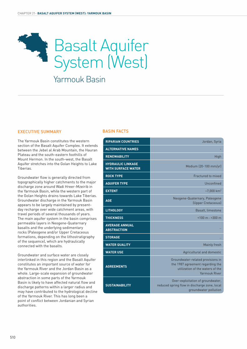
Chapter 21 Yarmouk Basin
Basalt Aquifer System (West)
How to citeUN-ESCWA and BGR (United Nations Economic and Social Commission for Western Asia; Bundesanstalt für Geowissenschaften und Rohstoffe). 2013. Inventory of Shared Water Resources in Western Asia. Beirut.
INVENTORY OF
SHARED WATER RESOURCES IN WESTERN ASIA (ONLINE VERSION)
510
CHAPTER 21- BASALT AQUIFER SYSTEM (WEST): YARMOUK BASIN
EXECUTIVE SUMMARY
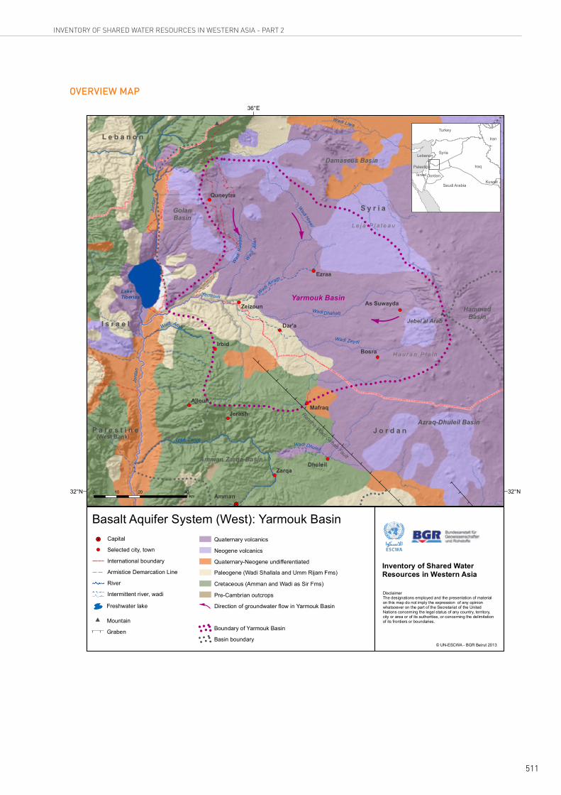
The Yarmouk Basin constitutes the western section of the Basalt Aquifer Complex. It extends between the Jebel al Arab Mountain, the Hauran Plateau and the south-eastern foothills of Mount Hermon. In the south-west, the Basalt Aquifer stretches into the Golan Heights to Lake Tiberias.
Groundwater flow is generally directed from topographically higher catchments to the major discharge zone around Wadi Hreer-Mzeirib in the Yarmouk Basin, while the western part of the Golan Heights drains towards Lake Tiberias. Groundwater discharge in the Yarmouk Basin appears to be largely maintained by present-day recharge over wide catchment areas, with travel periods of several thousands of years. The main aquifer system in the basin comprises permeable layers in Neogene-Quaternary basalts and the underlying sedimentary rocks (Paleogene and/or Upper Cretaceous formations, depending on the lithostratigraphy of the sequence), which are hydraulically connected with the basalts.
Groundwater and surface water are closely interlinked in this region and the Basalt Aquifer constitutes an important source of water for the Yarmouk River and the Jordan Basin as a whole. Large-scale expansion of groundwater abstraction in some parts of the Yarmouk Basin is likely to have affected natural flow and discharge patterns within a larger radius and may have contributed to the hydrological decline of the Yarmouk River. This has long been a point of conflict between Jordanian and Syrian authorities.
BASIN FACTS
Jordan, SyriaRIPARIAN COUNTRIES
-ALTERNATIVE NAMES
HighRENEWABILITY
Medium (20-100 mm/yr)HYDRAULIC LINKAGE WITH SURFACE WATER
Fractured to mixedROCK TYPE
UnconfinedAQUIFER TYPE
~7,000 km2EXTENT
Neogene-Quaternary, Paleogene (Upper Cretaceous)
AGE
Basalt, limestoneLITHOLOGY
<100 m - >300 mTHICKNESS
..AVERAGE ANNUAL ABSTRACTION
..STORAGE
Mainly freshWATER QUALITY
Agricultural and domesticWATER USE
Groundwater-related provisions in the 1987 agreement regarding the
utilization of the waters of the Yarmouk River
AGREEMENTS
Over-exploitation of groundwater, reduced spring flow in discharge zone, local
groundwater pollutionSUSTAINABILITY
Basalt Aquifer System (West) Yarmouk Basin
511
INVENTORY OF SHARED WATER RESOURCES IN WESTERN ASIA - PART 2
!!
!!
!!
!
!!
!!!!
!!
!!
!!
!!
!!
!!!
!
!!
!! ! ! ! ! ! ! ! ! ! ! ! ! ! ! !
!!
!!
!!
!
!! ! ! ! ! ! !
!! ! ! ! ! ! ! ! !
! ! ! !
!
! ! ! !!
!!
! ! ! ! !!
!!
!!
!
!!
! ! ! !!
!
!!
!!
!!
!!
!!
!!
!!
!!
!!
!!
!!
!!
!!
!!
!!
!!
!!
!!!
!!!
!! ! ! ! !
!
!!
!
!!
!!
!!
!!
!!
!!
!!
!!
! ! ! ! !! !
!! !
!!
!!!
!!
!!
!!
!!
!!
!
!!!!
!!
!!
!!
!!
!!
!!
!!
!!
!!!!!!!!!
!
!!
!
!!!!
!!
!
!!
!
!!
!!
!!
!!
!!
!!
!!
!!
!!
!
!!
!!
!
!!
!!
!
!!
!!
!!
!!
!!
!!
!!
!!
!!
!!
! ! !
!!
!!
!!
!!
!!
!
!!
!!
!!
!!
!!
!!
!!
!
!!
!!
!!!!!!!!!!!!!!!!!!!!!!!!!!!!!!
!!
!
!!!
!!
!!
!!
!!
!!
!!
!!
!!
!!
! ! ! ! ! ! ! ! ! ! !!
!
!!
!!
!!
!
!!
!!
! ! ! ! ! !!
!
!!
!!!
!!
!!
!
!!
!
!!
!!
!!!!
!!
!!
!!
!!
!!
!!
!!
!!
!
!!
!!
!!
!!!!!!!!!!!!!!!!!
!!
!!
!!
!!!!!!!
!!!!!!!!!!!!!!
!!
!!
!!
!!
!!
!!
!!
!!
!
!!!!!!
!!
!!
!!
!!
!!
!!
!!
!!
!!
!!
!!
!!
!!
!!
!!
!!
!!
!!
!!
!
!! !
#
#
!H
!H
AzraqAmman
Damascus
Amman
Zarqa
Bosra
Dar'a
Irbid
Ajloun
JerashMafraq
As Suwayda
Quneytra
36°E
32°N 32°N
Basalt Aquifer System (West): Yarmouk Basin
Azraq-Dhuleil Basin
Yarmouk BasinHammad
Basin
Damascus Basin
GolanBasin
Jord
an
LakeTiberias
Yarmouk
Amman Zarqa Basin
Ramtha-Wadi Sirhan Fault
Capital!H
Selected city, town
International boundary
River
Intermittent river, wadi
Paleogene (Wadi Shallala and Umm Rijam Fms)
Quaternary volcanics
Quaternary-Neogene undifferentiated
Cretaceous (Amman and Wadi as Sir Fms)
Pre-Cambrian outcrops
Direction of groundwater flow in Yarmouk Basin
Neogene volcanics
Basin boundary
Boundary of Yarmouk BasinGraben
Freshwater lake
Armistice Demarcation Line
0 20 4010km
Inventory of Shared Water Resources in Western Asia
© UN-ESCWA - BGR Beirut 2013
# Mountain
DisclaimerThe designations employed and the presentation of material on this map do not imply the expression of any opinion whatsoever on the part of the Secretariat of the United Nations concerning the legal status of any country, territory, city or area or of its authorities, or concerning the delimitation of its frontiers or boundaries.
JordanIsrael
Turkey
Syria
Saudi ArabiaKuwait
Iraq
Lebanon
S y r i a
J o r d a nP a l e s t i n e(West Bank)
M o u n t H e r m o n
Dhuleil
Wadi
Wadi Zeydi
Dhahab
Wad
iR
aqqa
d
Wadi Zarqa
Wad
iA
llan
Wadi
Wadi Liwa
L e j a P l a t e a u
H a u r a n P l a i n
Zeizoun
Arab
WadiArram
Wadi Hreer
Ezraa
!
!!!!
! !
Dhuleil
Wadi
I s r a e l
L e b a n o n
Jebel al Arab
!
!!!
!
! !
Jord
an
Iran
Palestine
OVERVIEW MAP
512
CHAPTER 21- BASALT AQUIFER SYSTEM (WEST): YARMOUK BASIN
CONTENTS
514INTRODUCTION515Location
515Area
515Climate
515Population
515Other aquifers in the area
515Information sources
516HYDROGEOLOGY - AQUIFER CHARACTERISTICS516Aquifer configuration
516Stratigraphy
517Aquifer thickness
517Aquifer type
517Aquifer parameters
519HYDROGEOLOGY - GROUNDWATER519Recharge
519Flow regime
519Storage
519Discharge
520Water quality
521Exploitability
522GROUNDWATER USE522Groundwater abstraction and use
522Groundwater quality issues
522Sustainability issues
524AGREEMENTS, COOPERATION & OUTLOOK524Agreements
524Cooperation
524Outlook
525NOTES
526BIBLIOGRAPHY
513
INVENTORY OF SHARED WATER RESOURCES IN WESTERN ASIA - PART 2
FIGURES
TABLES
BOXES
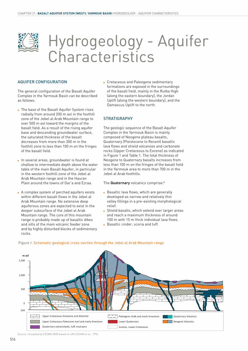
516Schematic geological cross-section through the Jebel al Arab Mountain rangeFIGURE 1.
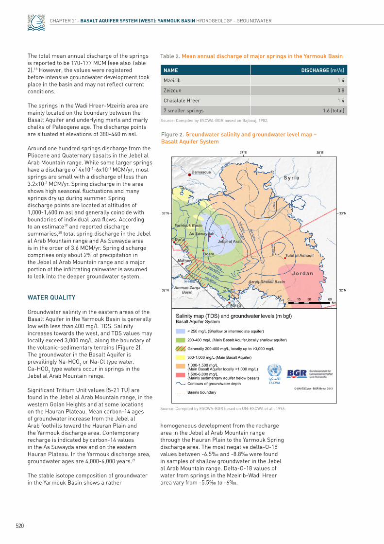
520Groundwater salinity and groundwater level map – Basalt Aquifer SystemFIGURE 2.
522Groundwater use and irrigated areas in the Yarmouk Basin in Syria (1999-2009)FIGURE 3.
517Lithostratigraphy of volcanic and sedimentary formations in the Basalt Aquifer ComplexTABLE 1.
520Mean annual discharge of major springs in the Yarmouk BasinTABLE 2.
523The Golan HeightsBOX 1.
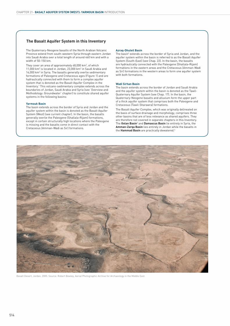
Basalt Desert, Jordan, 2005. Source: Robert Bewley, Aerial Photographic Archive for Archaeology in the Middle East.
CHAPTER 21- BASALT AQUIFER SYSTEM (WEST): YARMOUK BASIN INTRODUCTION
514
The Quaternary-Neogene basalts of the North Arabian Volcanic Province extend from south-western Syria through eastern Jordan into Saudi Arabia over a total length of around 460 km and with a width of 50-150 km. They cover an area of approximately 48,000 km2, of which 11,000 km2 is located in Jordan, 23,000 km2 in Saudi Arabia and 14,000 km2 in Syria. The basalts generally overlie sedimentary formations of Paleogene and Cretaceous ages (Figure 1) and are hydraulically connected with them to form a complex aquifer system that is denoted as the Basalt Aquifer Complex in the Inventory.1 This volcano-sedimentary complex extends across the boundaries of Jordan, Saudi Arabia and Syria (see ‘Overview and Methodology: Groundwater’ chapter) to constitute shared aquifer systems in the following basins: Yarmouk Basin The basin extends across the border of Syria and Jordan and the aquifer system within the basin is denoted as the Basalt Aquifer System (West) (see current chapter). In the basin, the basalts generally overlie the Paleogene (Shallala-Rijam) formations, except in certain structurally high locations where the Paleogene is missing and the basalts come in direct contact with the Cretaceous (Amman-Wadi as Sir) formations.
Azraq-Dhuleil Basin The basin2 extends across the border of Syria and Jordan, and the aquifer system within the basin is referred to as the Basalt Aquifer System (South-East) (see Chap. 22). In the basin, the basalts are hydraulically connected with the Paleogene (Shallala-Rijam) formations in the eastern areas and the Cretaceous (Amman-Wadi as Sir) formations in the western areas to form one aquifer system with both formations.
Wadi Sirhan Basin The basin extends across the border of Jordan and Saudi Arabia and the aquifer system within the basin is denoted as the Tawil-Quaternary Aquifer System (see Chap. 17). In the basin, the Quaternary-Neogene basalts and alluvium form the upper part of a thick aquifer system that comprises both the Paleogene and Cretaceous (Tawil-Sharawra) formations.The Basalt Aquifer Complex, which was originally delineated on the basis of surface drainage and morphology, comprises three other basins that are of less relevance as shared aquifers. They are therefore not covered in separate chapters in this Inventory. The Golan Basin3 and Damascus Basin lie entirely in Syria, the Amman-Zarqa Basin lies entirely in Jordan while the basalts in the Hammad Basin are practically dewatered.4
The Basalt Aquifer System in this Inventory
515
INVENTORY OF SHARED WATER RESOURCES IN WESTERN ASIA - PART 2
IntroductionLOCATION
The Basalt Aquifer System (West), hereafter referred to as the Yarmouk Basin, covers wide areas of south-western Syria and a smaller area in north-western Jordan (see Overview Map). It extends from the Jebel al Arab Mountain range in the east over the Hauran Plateau to the foothills of Mount Hermon in the west; and from the Quneytra area in the north to the border area between Jordan and Syria and the Wadi Hreer–Mzeirib groundwater discharge area near the Yarmouk River in the south-west. South of Mount Hermon, the basalt area extends through the Golan Heights to Lake Tiberias (Box 1). To the south-east, it is bordered by the Azraq-Dhuleil Basin, which is shared between Jordan and Syria (see Chap. 22). To the east and north, the basin is bounded by the Hammad and Damascus Basins.
AREA
The morphology of the basin is dominated by the 1,500 m peaks of the Jebel al Arab Mountain range in the east, with the 1,803 m Tell Ghani as its highest peak. The Golan Heights in the south-west reach a maximum altitude of approximately 1,200 m asl. The Hauran Plateau, which adjoins the Jebel al Arab Mountain range in the west, slopes gently to 500 m asl towards the Yarmouk River valley, which cuts into the basalt field to a depth of around 450 m asl. To the west, the Hauran Plateau grades into the Golan Heights, a basalt plateau which descends from an altitude of about 900 m asl on its north-eastern edge to 250 m asl in the Yarmouk River valley in the south. In the west of the Golan Heights, altitudes drop from 700 m asl to 212 m bsl on the shore of Lake Tiberias.
The boundaries of the aquifer system of the Yarmouk Basin coincide approximately with the water divides with neighbouring hydrologic basins (Azraq-Dhuleil, Damascus, Amman-Zarqa, Golan and Hammad Basins). In the south-west, the basin boundary is defined by the limits of the basalt field near the Yarmouk River. In a limited area in the south-west (near Dar’a and
Mafraq), the boundary of the Basalt Aquifer is formed by the limit of the extent of the saturated aquifer.
Based on surface topography, the Yarmouk Basin covers an overall area of around 6,900 km2, of which around 5,150 km2 are covered in outcrops of basaltic rocks. In parts of the Hauran Plain in Syria, the basalts are overlain by a thick soil cover.
CLIMATE
The climate in the Yarmouk Basin is typically Mediterranean, with cold, rainy winters and dry, warm summers extending from May until October. Average annual precipitation ranges from 500 mm in the Jebel al Arab Mountain range and Golan Heights to 250-300 mm in the Hauran Plain.
POPULATION
The Yarmouk Basin has an estimated total population of around 1.6 million. The Syrian part of the basin has around 1.2 million inhabitants in the governorate of Dar’a, as well as parts of As Suwayda and Quneytra Governorates.5 In Jordan, the basin extends over parts of the governorates of Irbid and Mafraq, with around 443,000 inhabitants.6
OTHER AQUIFERS IN THE AREA
There are no other significant aquifers in the area given that all major aquifers of Quaternary, Neogene, Paleogene and Upper Cretaceous age in the area are, to a varying degree and depending on location, hydraulically connected and considered part of the Basalt Aquifer Complex in this Inventory.
INFORMATION SOURCES
Information for this chapter was mainly derived from a 1996 study,7 in addition to more recent regional and local publications as listed in the bibliography.
~~~~~~~~~~ ~~~~ ~~~~ ~ ~~ ~~ ~ ~~
~~~
~~ ~~
~~~
~ ~~~~
~~~ ~~ ~~ ~ ~~ ~~
~ ~~~~~~~~~~~~~~~~~~~~~ ~~~ ~~ ~~~~~~~ ~~~ ~ ~ ~~ ~~ ~~ ~
~~ ~~ ~~~~~~~ ~~ ~~ ~~~~ ~ ~ ~ ~ ~ ~ ~ ~ ~~
~~~~~
516
CHAPTER 21- BASALT AQUIFER SYSTEM (WEST): YARMOUK BASIN HYDROGEOLOGY - AQUIFER CHARACTERISTICS
Hydrogeology - Aquifer Characteristics
AQUIFER CONFIGURATION
The general configuration of the Basalt Aquifer Complex in the Yarmouk Basin can be described as follows:
The base of the Basalt Aquifer System rises radially from around 200 m asl in the foothill zone of the Jebel al Arab Mountain range to over 500 m asl toward the margins of the basalt field. As a result of the rising aquifer base and descending groundwater surface, the saturated thickness of the basalt decreases from more than 300 m in the foothill zone to less than 100 m on the fringes of the basalt field.
In several areas, groundwater is found at shallow to intermediate depth above the water table of the main Basalt Aquifer, in particular in the western foothill zone of the Jebel al Arab Mountain range and in the Hauran Plain around the towns of Dar’a and Ezraa.
A complex system of perched aquifers exists within different basalt flows in the Jebel al Arab Mountain range. No extensive deep aquiferous zones are expected to exist in the deeper subsurface of the Jebel al Arab Mountain range. The core of this mountain range is probably made up of basaltic dikes and sills of the main volcanic feeder zone and by highly disturbed blocks of sedimentary rocks.
Figure 1. Schematic geological cross-section through the Jebel al Arab Mountain range
Cretaceous and Paleogene sedimentary formations are exposed in the surroundings of the basalt field, mainly in the Rutba High (along the eastern boundary), the Jordan Uplift (along the western boundary), and the Damascus Uplift to the north.
STRATIGRAPHY
The geologic sequence of the Basalt Aquifer Complex in the Yarmouk Basin is mainly composed of Neogene plateau basalts, Quaternary (Pleistocene to Recent) basaltic lava flows and shield volcanoes and carbonate rocks (Upper Cretaceous to Eocene) as indicated in Figure 1 and Table 1. The total thickness of Neogene to Quaternary basalts increases from less than 100 m on the fringes of the basalt field in the Yarmouk area to more than 700 m in the Jebel al Arab foothills.
The Quaternary volcanics comprise:8
Basaltic lava flows, which are generally developed as narrow and relatively thin valley fillings in a pre-existing morphological relief. Shield basalts, which extend over larger areas
and reach a maximum thickness of around 100 m with 15 m thick individual lava flows. Basaltic cinder, scoria and tuff.
Upper Cretaceous limestone and dolomite Paleogene chalk and marly limestone Quaternary Volcanics
Lower Quaternary
Jurassic, Lower-Cretaceous
Neogene VolcanicsUpper Cretaceous-Paleocene marl and marly limestone
YƵĂƚĞƌŶĂƌLJ�ǀŽůĐĂŶŝĐůĂƐƟĐ͕�ƚƵī͕�ŵƵĚ�ƉĂŶƐ
1,500
m asl
1,000
500
0
-250
Source: Compiled by ESCWA-BGR based on UN-ESCWA et al., 1996.
517
INVENTORY OF SHARED WATER RESOURCES IN WESTERN ASIA - PART 2
Table 1. Lithostratigraphy of volcanic and sedimentary formations in the Basalt Aquifer Complex
Source: Compiled by ESCWA-BGR based on UN-ESCWA et al., 1996; Ibrahim, 1993; Selkhozpromexport, 1986.(a) In Syria the formations are commonly referred to by age (epoch/stage) in combination with lithological characteristics.
The Neogene, mainly Pliocene, plateau basalts are composed of single lava sheets, which are crossed by numerous basaltic dikes. Individual lava sheets are generally several metres thick, and may be separated by soil or sedimentary layers. The Neogene basalt is assumed to reach a maximum thickness of about 1,500 m beneath the Jebel al Arab Mountain range.9 Neogene basalts are exposed mainly in the east of the Yarmouk Basin. In the west of the basin, the Neogene basalts are generally covered by younger Quaternary basalts.
In the Lake Tiberias-Yarmouk area, the basalts overlie terrestrial deposits of lower Pliocene age. The thickness of the Pliocene basalts increases from a few tens of metres around Lake Tiberias to 200 m in Wadi Raqqad. A late Pliocene age sequence of basalt flows with a thickness of 30-200 m extends over wide areas of the Golan Heights. The Pliocene basalts appear to originate mainly from extrusions in the Hauran-Jebel al Arab area, while secondary extrusions (plugs, small volcanoes, fissure dykes) are scattered over the Golan Heights.
Paleogene sedimentary rocks generally underlie the basalts. In a small belt in the south of the Yarmouk Basin, the Paleogene chalks and Upper Cretaceous-Paleogene marls may be missing over a structural high, leaving the basalts in direct contact with underlying Upper Cretaceous limestones and dolomites. The Paleogene is prevailingly represented by marly sediments, which are exposed near Dar’a and underlie the basalts elsewhere across the basin. Their thickness could vary between 0 and 220 m.
Outcrops of Upper Cretaceous limestones and dolomites cover the south-western part of the basin and the total thickness of the formations in the area is estimated at 270-360 m or more.
AQUIFER THICKNESS
The saturated thickness of the basalt increases from less than 100 m in the Yarmouk area on the south-western fringes of the basalt field to more than 300 m in the foothill zone of the Jebel al Arab Mountain range. The Paleogene aquiferous rocks may add another 200 m to the total aquifer thickness.
AQUIFER TYPE
The basalts of the Yarmouk Basin constitute a generally unconfined main aquifer; semi-confined conditions occur locally within individual volcanic flows. Perched groundwater bodies exist, particularly in the Jebel al Arab Mountain range, where numerous small springs discharge above low permeability layers within the volcanic rock sequence.
AQUIFER PARAMETERS
Permeable horizons within the Basalt Aquifer Complex comprise 10%-20% of the total saturated thickness of the Basalt Aquifer. Accordingly, transmissivity values of between 3.47x10⁻⁴ and 1.5x10⁻² m!/s and permeabilities of 2x10⁻⁴ to 6x10⁻⁴ m/s may be assumed (see Chap. 22). Relatively high well capacities, which occur in some areas, may be related to the high transmissivity of the underlying carbonate aquifers, which are hydraulically connected with the Basalt Aquifer.10
Transmissivity values from single well tests are reported to range from 2.8x10⁻¹ to 1.2x10⁻¹ m!/s in the eastern part of the Hauran Plain and the Leja Plateau in Syria. Transmissivity decreases in the western part of the basin.11
PERIOD EPOCH/STAGE LITHOLOGY NAMES OF FORMATIONS IN JORDANa
Quaternary
Upper-Middle Quaternary
Basaltic lava flows and shield basalts
Fahda Vesicular Basalt and Wadi Manasif Basalt formations, mainly in the southern part of the Azraq Basin
Lower Quaternary
Valley filling lava flows and shield basalts
Hassan Scoriaceous, Madhala Olivine Phyric Basalt, and Abed Olivine Phyric Basalt formations; crops out in wide parts of the Azraq Basin
Tertiary
Pliocene-Miocene Plateau basalts ..
Eocene Chalk, chalky limestone, chert Wadi Shallala and Umm Rijam Formations (B4/B5)
Upper Cretaceous-Tertiary
Maastrichtian- Paleocene
Marl, chalk, bituminous limestone Muwaqqar Formation (B3)
Upper Cretaceous(Campanian-) Turonian- Cenomanian
Limestone, dolomite, marl Wadi as Sir and Amman Formations (A7/B2)
518
CHAPTER 21- BASALT AQUIFER SYSTEM (WEST): YARMOUK BASIN HYDROGEOLOGY - AQUIFER CHARACTERISTICS
Well yields are relatively high around As Suwayda in the north-western part of the Jebel al Arab Mountain range, which comprises a complex sequence of aquiferous sections within the basalt with one or two perched aquifer zones above the main Basalt Aquifer. In the area
west of the Jebel al Arab Mountain range (Dar’a-Ezraa-Bosra), well yields and specific capacities are low to moderate, but relatively high specific capacities are indicated for a number of wells, in which zero drawdown is observed during operation.12
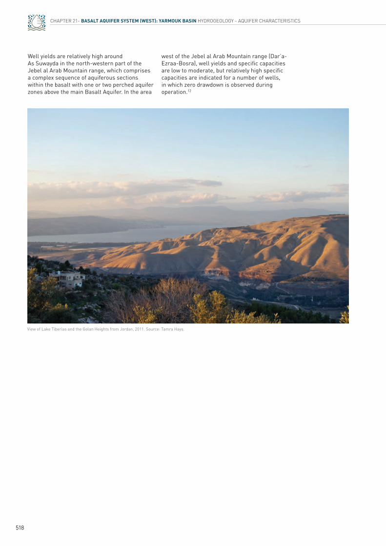
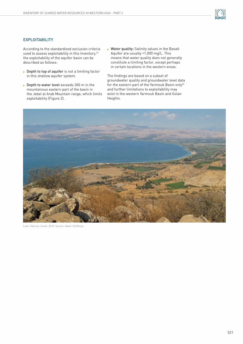
View of Lake Tiberias and the Golan Heights from Jordan, 2011. Source: Tamra Hays.
519
INVENTORY OF SHARED WATER RESOURCES IN WESTERN ASIA - PART 2
Hydrogeology - Groundwater
RECHARGE
Favourable recharge conditions exist in areas with mean annual precipitation of more than 300 mm such as the Jebel al Arab Mountain range, the western part of the Hauran Plain and the Golan Heights. Indirect recharge occurs in wadi systems, where seasonal runoff infiltrates. Recharge conditions appear to be relatively favourable on outcrops of Neogene and Quaternary shield basalts with very limited soil cover, e.g. in the Jebel al Arab Mountain range and on the Leja Plateau.
Significant groundwater recharge from present-day precipitation is evident, particularly in the shallow groundwater of the Jebel al Arab Mountain range, the foothills near As Suwayda and in the Wadi Liwa-Leja area north-west of As Suwayda. The following factors indicate recent recharge: 13
The immediate response of spring discharge to the seasonal precipitation
Low groundwater salinity
Occurrence of perched groundwater
Significant tritium values
Recharge volumes may be relatively low in parts of the Hauran Plain, where thick soil has developed. In general, direct and indirect recharge in the Yarmouk Basin amounts to 6% of precipitation.14
FLOW REGIME
In the Yarmouk Basin, groundwater flows from topographically higher areas to the main groundwater discharge zones at Wadi Hreer-Mzeirib near the Yarmouk River in the south (see Overview Map). However, these natural flow paths may have been altered by agricultural development and the drilling of hundreds of irrigation wells. This section only describes the natural flow paths.
Groundwater flows over the Hauran Plain to the discharge zone from the following locations:
The western foothill zone of the Jebel al Arab Mountain range in the east/north-east of the basin.
The narrow hydrologic Wadi Liwa Basin and the southern margins of the Damascus Plain in the north.
The foothills of Mount Hermon and the eastern part of the Golan Heights in the north-west.
Groundwater temperature and salinity increase along the different flow paths, from around 11.5°C in the foothills of the different mountain ranges to 25°C in the major Yarmouk Springs in the south-west. The common outflow of the Yarmouk Basin at major spring outlets can be verified by groundwater samples collected throughout the basin. The major spring outlets discharge water of different origins: water from the Mount Hermon and the Jebel al Arab foothills is admixed with recharge water from the Hauran Plain.15 Groundwater flow velocities range from 20 to 60 m/yr in the central Hauran Plain. Flow velocities in the major recharge areas in the Jebel al Arab Mountain range and near Mount Hermon are much smaller (1-7 m/yr).16 The lowest groundwater ages are found in the Jebel al Arab and Mount Hermon foothills and in the Golan Heights (1,000 years), while higher groundwater ages were registered at the major springs (5,000 years). Groundwater ages of more than 10,000 years were found in the south close to the Jordanian-Syrian border, indicating very low flow velocities and recharge, possibly during the late pluvial phase of the Holocene period.17 Groundwater from the various perched aquifers in the basalt area leaks into the deeper main groundwater system.
STORAGE
Information on groundwater storage was not available.
DISCHARGE
Major groundwater discharge from the Basalt Aquifer System (West) in the Yarmouk Basin occurs at Wadi Hreer-Mzeirib in the south-west of the basalt field near the Yarmouk River. Mean discharge of spring groups at Zeizoun amounts to 25.2 MCM/yr, while mean discharge of springs at Mzeirib and Chalalate Hreer is 44.2 MCM/yr. Several smaller springs in the area have mean discharges between 3.2 and 10.4 MCM/yr.
520
CHAPTER 21- BASALT AQUIFER SYSTEM (WEST): YARMOUK BASIN HYDROGEOLOGY - GROUNDWATER
!H
!H
Irbid
Ajloun
Jerash
Qunaitra
Jabal El Sheikh
100 - 200m
>400m
200-300m
300-400m
<50m
300-400m
50-100m
50-100m
50-100m
<50m
Damascus
Azraq
Bosra
Dar'a
Mafraq
As Suwaydah
Jebel al Arab
Tulul al Ashaqif
38°E37°E
33°N 33°N
32°N 32°N
100-200m
50-100m
Salinity map (TDS) and groundwater levels (m bgl)
< 250 mg/L (Shallow or intermediate aquifer)
200-400 mg/L (Main Basalt Aquifer,locally shallow aquifer)
300-1,000 mg/L (Main Basalt Aquifer)
1,000-1,500 mg/L(Main Basalt Aquifer locally <1,000 mg/L)
1,500-6,000 mg/L(Mainly sedimentary aquifer below basalt)
Contours of groundwater depth
Basalt Aquifer System
200-300m
300-400m
>400m
Generally 200-400 mg/L, locally up to >3,000 mg/L
0 30 6015km
Amman-ZarqaBasin
Azraq-Dhuleil Basin
Yarmouk Basin
S y r i a
J o r d a n
© UN-ESCWA - BGR Beirut 2013
! ! Basins boundary
homogeneous development from the recharge area in the Jebel al Arab Mountain range through the Hauran Plain to the Yarmouk Spring discharge area. The most negative delta-O-18 values between -6.5‰ and -8.8‰ were found in samples of shallow groundwater in the Jebel al Arab Mountain range. Delta-O-18 values of water from springs in the Mzeirib-Wadi Hreer area vary from -5.5‰ to -6‰.
Table 2. Mean annual discharge of major springs in the Yarmouk Basin
Source: Compiled by ESCWA-BGR based on Bajbouj, 1982.
Source: Compiled by ESCWA-BGR based on UN-ESCWA et al., 1996.
NAME DISCHARGE (m3/s)
Mzeirib 1.4
Zeizoun 0.8
Chalalate Hreer 1.4
7 smaller springs 1.6 (total)
Figure 2. Groundwater salinity and groundwater level map – Basalt Aquifer System
The total mean annual discharge of the springs is reported to be 170-177 MCM (see also Table 2).18 However, the values were registered before intensive groundwater development took place in the basin and may not reflect current conditions.
The springs in the Wadi Hreer-Mzeirib area are mainly located on the boundary between the Basalt Aquifer and underlying marls and marly chalks of Paleogene age. The discharge points are situated at elevations of 380-440 m asl.
Around one hundred springs discharge from the Pliocene and Quaternary basalts in the Jebel al Arab Mountain range. While some larger springs have a discharge of 4x10⁻¹-6x10⁻¹ MCM/yr, most springs are small with a discharge of less than 3.2x10⁻² MCM/yr. Spring discharge in the area shows high seasonal fluctuations and many springs dry up during summer. Spring discharge points are located at altitudes of 1,000-1,600 m asl and generally coincide with boundaries of individual lava flows. According to an estimate19 and reported discharge summaries,20 total spring discharge in the Jebel al Arab Mountain range and As Suwayda area is in the order of 3.6 MCM/yr. Spring discharge comprises only about 2% of precipitation in the Jebel al Arab Mountain range and a major portion of the infiltrating rainwater is assumed to leak into the deeper groundwater system.
WATER QUALITY
Groundwater salinity in the eastern areas of the Basalt Aquifer in the Yarmouk Basin is generally low with less than 400 mg/L TDS. Salinity increases towards the west, and TDS values may locally exceed 3,000 mg/L along the boundary of the volcanic-sedimentary terrains (Figure 2). The groundwater in the Basalt Aquifer is prevailingly Na-HCO3 or Na-Cl type water. Ca-HCO3 type waters occur in springs in the Jebel al Arab Mountain range.
Significant Tritium Unit values (5-21 TU) are found in the Jebel al Arab Mountain range, in the western Golan Heights and at some locations on the Hauran Plateau. Mean carbon-14 ages of groundwater increase from the Jebel al Arab foothills toward the Hauran Plain and the Yarmouk discharge area. Contemporary recharge is indicated by carbon-14 values in the As Suwayda area and on the eastern Hauran Plateau. In the Yarmouk discharge area, groundwater ages are 4,000-6,000 years.21
The stable isotope composition of groundwater in the Yarmouk Basin shows a rather
521
INVENTORY OF SHARED WATER RESOURCES IN WESTERN ASIA - PART 2
Lake Tiberias, Israel, 2010. Source: Adam Groffman.
EXPLOITABILITY
According to the standardized exclusion criteria used to assess exploitability in this Inventory,22 the exploitability of the aquifer basin can be described as follows:
Depth to top of aquifer is not a limiting factor in this shallow aquifer system.
Depth to water level exceeds 300 m in the mountainous eastern part of the basin in the Jebel al Arab Mountain range, which limits exploitability (Figure 2).
Water quality: Salinity values in the Basalt Aquifer are usually <1,000 mg/L. This means that water quality does not generally constitute a limiting factor, except perhaps in certain locations in the western areas. The findings are based on a subset of groundwater quality and groundwater level data for the eastern part of the Yarmouk Basin only23 and further limitations to exploitability may exist in the western Yarmouk Basin and Golan Heights.
522
CHAPTER 21- BASALT AQUIFER SYSTEM (WEST): YARMOUK BASIN GROUNDWATER USE
Groundwater UseGROUNDWATER ABSTRACTION AND USE
Groundwater is extracted from a large number of drilled wells in the Yarmouk Basin, with wells that are used mainly for agricultural purposes scattered across the western foothills of the Jebel al Arab Mountain range and the Hauran Plateau.
In Jordan, most of the abstraction in the Yarmouk Basin is not from the Basalt Aquifer System itself but from the Upper Cretaceous carbonate aquifer (A7/B2 aquifer), which is partly covered by Pleistocene basalt.24 Disaggregated abstraction figures for the individual aquifers and locations were not available, and groundwater abstraction from the whole basin in Jordan was around 50-57 MCM/yr during the last decade.25 In 2010, there were 166 operational wells in the basin, most of which were used for agricultural purposes.26
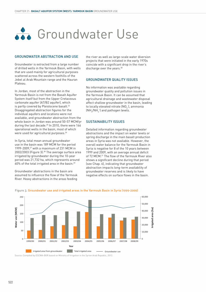
In Syria, total mean annual groundwater use in the basin was 189 MCM for the period 1999-2009,27 with a maximum of 231 MCM in 2002/2003 (Figure 3).28 The average surface area irrigated by groundwater during the 10-year period was 21,732 ha, which represents around 60% of the total irrigated area in the basin.29
Groundwater abstractions in the basin are assumed to influence the flow of the Yarmouk River. Heavy abstractions in the areas feeding
the river as well as large-scale water diversion projects that were initiated in the early 1970s coincide with a significant drop in the river’s discharge over the years.30
GROUNDWATER QUALITY ISSUES
No information was available regarding groundwater quality and pollution issues in the Yarmouk Basin. It can be assumed that agricultural drainage and wastewater disposal affect shallow groundwater in the basin, leading to locally elevated nitrate (NO3
-), ammonia (NH3/NH4
+) and pathogen levels.
SUSTAINABILITY ISSUES
Detailed information regarding groundwater abstractions and the impact on water levels or spring discharge in the main basalt production areas in Syria was not available. However, the overall water balance for the Yarmouk Basin in Syria is negative for 8 of the 10 years between 1999 and 2009, with an average annual deficit of 72 MCM.31 The flow of the Yarmouk River also shows a significant decline during that period (see Chap. 6), indicating that groundwater abstraction impacts long-term availability of groundwater reserves and is likely to have negative effects on surface flows in the basin.
Figure 3. Groundwater use and irrigated areas in the Yarmouk Basin in Syria (1999-2009)
Source: Compiled by ESCWA-BGR based on Ministry of Irrigation in the Syrian Arab Republic, 2012.
250 60,000
50,000
40,000
30,000
20,000
10,000
0
200
150
100
50
01999/00 2000/01 2001/02 2002/03 2003/04 2004/05 2005/06 2006/07 2007/08 2008/09
Wat
er u
se (M
CM)
Irrig
ated
are
a (h
a)
Year
Irrigated area from groundwater Total irrigated area Groundwater use
523
INVENTORY OF SHARED WATER RESOURCES IN WESTERN ASIA - PART 2
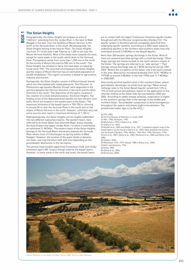
The Golan HeightsGeographically, the Golan Heights encompass an area of 1,860 km2, extending from the Jordan River in the west to Wadi Raqqad in the east, from the foothills of Mount Hermon in the north to the Yarmouk River in the south. Morphologically, the Golan Heights belong to the Hauran Plain. The Golan Heights rise from 211 m bsl near Lake Tiberias to 1,350 m asl near the Mount Hermon foothills. Most of the wadis drain towards the west, except for some wadis in the south, which drain to the Yarmouk River. Precipitation varies from more than 1,200 mm in the north (in the vicinity of Mount Hermon) to 500 mm in the south.a The Golan Heights are situated in Syria, but have been occupied by Israel since 1967. The area that encompasses the Golan Heights and the slopes of Mount Hermon has an estimated population of 40,400 inhabitants.b The region’s economy is based on agriculture, industry and tourism.Geologically, the Golan Heights consist of different basalt sheets which are intercalated with clayey paleosoils. The Pliocene- to Pleistocene-age basalts (Bashan Group)c were deposited in the syncline between the Hermon Anticline in the north and the Ajlun Anticline in the south.d The deposition of the layers resulted in the creation of a small elevated plateau: the Golan Heights. The feeding zones of the deposited sheet basalts are two volcanic cone belts, which are located in the eastern part of the Golan.e The maximum thickness of the basalt layers is 700-750 m, thinning to around 50 m near the Yarmouk River in the south and on the slopes of Mount Hermon in the north. However, estimates vary and some sources also report a maximum thickness of 1,100 m.f
Hydrogeologically, the Golan Heights can be roughly subdivided into two different subsurface basins. The western basin, here referred to as Golan Basin (see Overview Map), drains towards the Hula Graben and Upper Jordan River,g to which it contributes an estimated 21 MCM/yr.e The eastern basin of the Golan Heights belongs to the Yarmouk Basin and drains towards the Yarmouk River where most of it discharges via spring outlets in Wadi Raqqad.e However, the location of the water divide is dynamic, not static, and may therefore shift with time depending on the groundwater abstraction in the two basins.The almost impermeable uppermost Cretaceous chalk and chalky limestone layers (Mt. Scopus Group) underlie the basalt layers. However, in some areas in the north and south, the basalt layers
are in contact with the Upper Cretaceous limestone aquifer (Judea Group)i and with the Miocene conglomerates (Hordos Fm).i The aquifer system is therefore almost completely detached from underlying aquifer systems. According to a 2002 water balance, underlying aquifers in the northern and southern areas may only contribute around 2.5 MCM/yr to the Basalt Aquifer.j
More than 200 basaltic springs discharge in the Golan. Most of them are seasonal perched springs with a small discharge.e Other larger springs are mainly located on the north-western slopes of the Golan. The springs are referred to as “side springs”.e Their average annual discharge was 46.7 MCM during the period 1987-2005.a Before the occupation of the Golan, only a few wells existed in the area. Abstraction increased gradually from 3x10⁻¹ MCM/yr in 1979/80 to around 5 MCM/yr in the mid-1990s and 11.7 MCM/yr in 2000/2001.Only locally perched aquifers exist in the southern Golan, where groundwater discharges via small local springs.k Mean annual recharge rates to the Golan Basalt Aquifer varied from 12% to 16% of total annual precipitation, based on the application of the chloride method at the Golan Side Springs between 2002 and 2004.l According to stable isotope analyses, evaporation is higher in the southern springs than in the springs in the middle and northern Golan.l Groundwater composition is fairly homogenous throughout the system and shows slight mineralization. The predominant water type is Ca-Na-HCO3.
k
(a) HSI, 2006. (b) Central Bureau of Statistics in Israel, 2009. (c) Mor, 1986; Heimann, 1990. (d) Michelson, 1979 in Dafny et al., 2003. (e) Dafny et al., 2003. (f) Reshef et al., 2003 and Meiler et al., 2011. A detailed isopach map of the basalt layers can be found in Dafny et al., 2003. More detailed information can be found in Burdon, 1954; Wolfart, 1966; Mor, 1986; Heimann, 1990; Hirsch et al., 2001; Dafny et al., 2003; Shulman et al., 2004 and Dafny et al., 2006. (g) Siebert, 2005. (h) Michelson 1972, 1979; Gilead, 1988 in Dafny et al., 2003. (i) Kafri and Heimann, 1994. (j) Dafny, 2002. (k) Dafny et al., 2006. (l) Brielmann, 2008.
BOX
1
Mount Hermon in the Golan Heights, Syria, 2008. Source: Adel Samara.
524
CHAPTER 21- BASALT AQUIFER SYSTEM (WEST): YARMOUK BASIN AGREEMENTS, COOPERATION & OUTLOOK
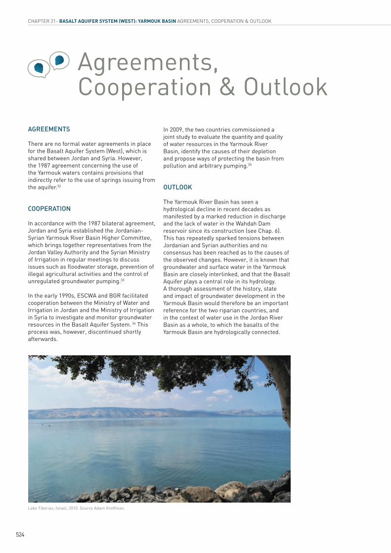
Lake Tiberias, Israel, 2010. Source Adam Groffman.
Agreements, Cooperation & Outlook
AGREEMENTS
There are no formal water agreements in place for the Basalt Aquifer System (West), which is shared between Jordan and Syria. However, the 1987 agreement concerning the use of the Yarmouk waters contains provisions that indirectly refer to the use of springs issuing from the aquifer.32
COOPERATION
In accordance with the 1987 bilateral agreement, Jordan and Syria established the Jordanian-Syrian Yarmouk River Basin Higher Committee, which brings together representatives from the Jordan Valley Authority and the Syrian Ministry of Irrigation in regular meetings to discuss issues such as floodwater storage, prevention of illegal agricultural activities and the control of unregulated groundwater pumping.33
In the early 1990s, ESCWA and BGR facilitated cooperation between the Ministry of Water and Irrigation in Jordan and the Ministry of Irrigation in Syria to investigate and monitor groundwater resources in the Basalt Aquifer System. 34 This process was, however, discontinued shortly afterwards.
In 2009, the two countries commissioned a joint study to evaluate the quantity and quality of water resources in the Yarmouk River Basin, identify the causes of their depletion and propose ways of protecting the basin from pollution and arbitrary pumping.35
OUTLOOK
The Yarmouk River Basin has seen a hydrological decline in recent decades as manifested by a marked reduction in discharge and the lack of water in the Wahdah Dam reservoir since its construction (see Chap. 6). This has repeatedly sparked tensions between Jordanian and Syrian authorities and no consensus has been reached as to the causes of the observed changes. However, it is known that groundwater and surface water in the Yarmouk Basin are closely interlinked, and that the Basalt Aquifer plays a central role in its hydrology. A thorough assessment of the history, state and impact of groundwater development in the Yarmouk Basin would therefore be an important reference for the two riparian countries, and in the context of water use in the Jordan River Basin as a whole, to which the basalts of the Yarmouk Basin are hydrologically connected.
INVENTORY OF SHARED WATER RESOURCES IN WESTERN ASIA - PART 2
525
Notes1. The aquifer system has also been referred to as
Jebel al Arab Aquifer based on the name of the mountain range (altitude: !1,800 m asl).
2. In the original study of the regional basalt aquifer system (UN-ESCWA et al., 1996), the Azraq and Dhuleil were considered to be separate basins on the basis of surface drainage and morphology. From a hydrogeological perspective, however, the two basins can be merged into one, since a significant part of groundwater in the Dhuleil Basin flows into the Azraq Basin in the area of the main discharge zone.
3. While the Golan Basin is not considered a shared aquifer, most of its basin area has been occupied by Israel since 1967 and the aquifer here discharges into the transboundary Jordan River Basin. Box 1 provides an overview of the Golan Basin.
4. UN-ESCWA et al., 1996.
5. Based on a 2004 population census (Central Bureau of Statistics in the Syrian Arab Republic, 2005) and 2010 estimates (Central Bureau of Statistics in the Syrian Arab Republic, 2011).
6. Based on 2011 estimates by Department of Statistics in Jordan, 2012. Small parts of Ajloun and Jerash Governorates are also included, but these areas are very sparsely populated.
7. UN-ESCWA et al., 1996.
8. Ibid.
9. Krasnov et al., 1966.
10. UN-ESCWA et al., 1996; Schelkes, 1997.
11. Bajbouj, 1982.
12. UN-ESCWA et al., 1996.
13. Ibid.
14. Schelkes, 1997; Wagner, 2011.
15. Droubi, 1991.
16. Kattan, 1996.
17. Ibid.
18. Burdon, 1954; Bajbouj, 1982.
19. Burdon, 1954.
20. UN-ESCWA et al., 1996.
21. Ibid.
22. The following criteria are used to assess exploitability in this Inventory: drilling depth/depth to top of aquifer; groundwater level; and water quality/salinity. For more information on the approach, see ‘Overview & Methodology: Groundwater’ chapter.
23. The study ‘Investigation of the Regional Basalt Aquifer System in Jordan and the Syrian Arab Republic’ (1996) covers only the eastern part of the Yarmouk Basin as delineated here. No data was available for the western part, including the Golan Heights.
24. Other main aquifers in the Yarmouk Basin in Jordan are A4, A1, 2 and Kurnub Sandstone (K).
25. Abstractions from the basin amounted to 57 MCM, 55 MCM and 49.9 MCM for the years 2002, 2003 and 2010 respectively (USAID, 2012; El-Naqa and Al-Shayeb, 2009). The safe yield is estimated at 40 MCM/yr.
26. USAID, 2012.
27. This represents around 58% of the total water used.
28. Ministry of Irrigation in the Syrian Arab Republic, 2012. Assuming that groundwater is only used for irrigation in the basin, the groundwater deficit for the period 1999-2009 was 4 MCM.
29. Ministry of Irrigation in the Syrian Arab Republic, 2012.
30. See Chap. 6 for more information on the Yarmouk River.
31. Ministry of Irrigation in the Syrian Arab Republic, 2012.
32. Article VII of the agreement stipulates:“Syria shall retain the right to the use of waters of all springs welling up within its territory in the basin of the Yarmuk and its tributaries, with the exception of the waters welling up above the dam below the 250-metre level...” (The Syrian Arab Republic and Jordan, 1987).
33. See Chap. 6 for more information.
34. UN-ESCWA et al., 1996.
35. Ministry of Water and Irrigation in Jordan, 2011. See also Jordan Times, 2009.
526
CHAPTER 21- BASALT AQUIFER SYSTEM (WEST): YARMOUK BASIN BIBLIOGRAPHY
BibliographyBajbouj, M. K. 1982. Le Bassin du Yarmouk: Etude Hydrologique et Hydrogéologique. Institut National Polytechnique de Lorraine, Nancy.
Brielmann, H. 2008. Recharge and Discharge Mechanism and Dynamics in the Mountainous Northern Upper Jordan River Catchment, Israel. PhD. Ludwig-Maximilians University, Faculty of Geosciences. Munich.
Burdon, D. J. 1954. Infiltration Rates in the Yarmouk Basin of Syria-Jordan. In Assemblée Générale de Rome, Comptes Rendus et Rapports de la Commission des Eaux Souterraines. Published by Association Internationale d’Hydrologie Scientifique.
Central Bureau of Statistics in Israel. 2009. Population Census 2008. Available at: http://www.cbs.gov.il/census/?MIval=%2Fcensus%2Fpnimi_sub2_tables_e.html&id_topic=11&id_subtopic=2&id_subtopic2=2&Geog=7. Accessed on March 8, 2012.
Central Bureau of Statistics in the Syrian Arab Republic. 2005. General Census, Population in the Areas and Suburbs 2004. Available at: http://cbssyr.org/General%20census/census%202004/pop-man.pdf. Accessed on October 15, 2010.
Central Bureau of Statistics in the Syrian Arab Republic. 2011. Statistical Abstract 2011. Available at: http://www.cbssyr.org/yearbook/2010/chapter2-EN.htm. Accessed on March 5, 2012.
Dafny, E. 2002. Hydrogeology of the Golan Heights Basalt Aquifer, Israel. MSc. Thesis (Hebrew). Hebrew University, Jerusalem.
Dafny, E., Burg, A. and Gvirtzman, H. 2006. Deduction of Groundwater Flow Regime in a Basaltic Aquifer Using Geochemical and Isotopic Data: The Golan Heights, Israel Case Study. Journal of Hydrology, 330: p. 506-524.
Dafny, E., Gvirtzman, H., Burg, A. and Fleischer, L. 2003. The Hydrogeology of the Golan Basalt Aquifer, Israel. Israel Journal of Earth Sciences, 52(3/4): p. 139-153.
Department of Statistics in Jordan. 2012. Population Estimates for 2011. Available at: http://www.dos.gov.jo/dos_home_a/main/2004/. Accessed on March 5, 2012.
Droubi, A. 1991. Geochemical and Isotope Study of the Yarmouk Basin. Unpublished work.
El-Naqa, A. and Al-Shayeb, A. 2009. Groundwater Protection and Management Strategy in Jordan. Water Resources Management, 23: p. 2379-2394.
Heimann, A. 1990. The Dead Sea Rift and its Margins Development in Northern Israel in the Pliocene and Pleistocene. PhD Thesis (Hebrew). Hebrew University, Jerusalem.
Hirsch, F., Fleischer, L., Roded, R. and Rosensaft, M. 2001. The Structural Maps of Mount Hermon, Golan Heights and NE Jordan: Stratigraphy and Tectonics. Published by GSI (Geological Survey of Israel). Jerusalem.
HSI (Hydrological Service of Israel). 2006. Development of Utilization and Status of Water Resources in Israel Until Autumn 2005 (in Hebrew). Jerusalem.
Ibrahim, K. 1993. Al Azraq, Map Sheet 3353I, 1:50000. Published by Natural Resources Authority. Amman.
Jordan Times. 2009. Jordan and Syria to Discuss Water Sharing Issues. Issued on October 6, 2009. Available at: http://www.emwis.net/thematicdirs/news/2009/10/jordan-and-syria-discuss-water-sharing-issues. Accessed on June 10, 2012.
Kafri, U. and Heimann, A. 1994. Reversal of the Palaeodrainage System in the Sea of Galilee Area as an Indicator of the Formation Timing of the Dead Sea Rift Valley Base Level in Northern Israel. Paleogeography, Paleoclimatology, Paleoecology, 109: p. 101-109.
Kattan, Z. 1996. Isotope Field Applications for Groundwater Studies in the Middle East. In Final Coordination Meeting of a Regional Technical Cooperation Project. Published by International Atomic Energy Agency. Ankara.
Krasnov, A. A., Kazmin, V. G. and Kulakov, V. V. 1966. The Geological Map of Syria 1:200000 Explanatory Notes. Sheets I-36-VI, I-37-I, II. Moscow.
Meiler, M., Reshef, M. and Shulman, H. 2011. Seismic Depth-domain Stratigraphic Classification of the Golan Heights, Central Dead Sea Fault. Tectonophysics, 510: p. 354–369.
Ministry of Irrigation in the Syrian Arab Republic. 2012. Country Consultation with the Syrian Arab Republic. In Country Consultations for the Inventory of Shared Water Resources in Western Asia 2011-2012. Beirut.
Ministry of Water and Irrigation in Jordan. 2011. Country Consultation with the Hashemite Kingdom of Jordan. In Country Consultations for the Inventory of Shared Water Resources in Western Asia 2011-2012. Beirut and Amman.
Mor, D. 1986. The Volcanism of the Golan Heights. PhD Thesis. Hebrew University, Jerusalem.
Reshef, M., Shulman, H. and Ben-Avraham, Z. 2003. A Case Study of Sub-basalt Imaging in Land Region Covered with Basalt Flows. Geophysical Prospecting, 51(3): p. 247-260.
Schelkes, K. 1997. Groundwater Balance of the Jordan-Syrian Basalt Aquifer. Published by BGR (Bundesanstalt für Geowissenschaften und Rohstoffe). Hannover.
Selkhozpromexport. 1986. Water Resources Use in Barada and Auvage Basins for Irrigation of Crops. Published by Syrian Arab Republic; USSR; Ministry of Land Reclamation and Water Management. Moscow.
Shulman, H., Reshef, M. and Ben-Avraham, Z. 2004. The Structure of the Golan Heights and its Tectonic Linkage to the Dead Sea Transform and the Palmyrides Folding. Israel Journal of Earth Sciences, 53(3-4): p. 225-237.
Siebert, C. 2005. Saisonale chemische Variationen des See Genezareth, seiner Zuflüsse und deren Ursachen. PhD Thesis. Freie Universität, Berlin.
The Syrian Arab Republic and Jordan. 1987. Agreement Concerning the Utilization of the Yarmuk Waters (with annex). Available at: http://www.internationalwaterlaw.org/documents/regionaldocs/Jordan-Syria-1987.pdf. Accessed on March 5, 2012.
UN-ESCWA, BGR, Ministry of Water and Irrigation in Jordan and Ministry of Irrigation in the Syrian Arab Republic (United Nations Economic and Social Commission for Western Asia; Bundesanstalt für Geowissenschaften und Rohstoffe). 1996. Investigation of the Regional Basalt Aquifer System in Jordan and Syria. Amman.
USAID (United States Agency for International Development). 2012. Review of Water Policies in Jordan and Recommendations for Strategic Priorities. In Jordan Water Sector Assessment.
Wagner, W. 2011. Groundwater in the Arab Middle East. Published by Springer-Verlag. Berlin, Heidelberg.
Wolfart, R. 1966. Zur Geologie und Hydrologie von Syrien unter besonderer Berücksichtigung der süd-und nordwestlichen Landesteile. In Geologisches Jahrbuch/ Beihefte.