Embed Size (px)
Citation preview
Die Watten der deutschen NordseekOste
Von Hans-Erich Reineck
1. Vorkommen
Die Siid- und teilweise die Ostkuste der Nordsee wird von Warren begrenzt. In
einer Gesamtlinge von 450 km erstrecken sie sich vor der niederlindischen, der deut-
schen und der diinischen Kiiste. Die Warren der sudlichen Nordsee sind durchschnittlich5 bis 7 km, maximal 10 bis 15 km breit. Sie werden von Flussen und zahlreichen Rin-
nell zerschnitten (Tafel III).
2. Hydrographie und Sedimenthaushalt
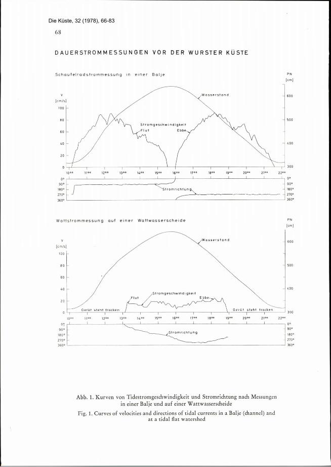
Die Tiden sind semidiurnal. Der Springtidehub liegt bei 2,6 m, maximal im Jade-busen bei 4,1 m. Der Nipptidehub betr t 1,8 m, im Jadebusen 3,1 m. Die Tidestr6-
mungen erreichen auf den Watten Geschwindigkeiten von 30 bis 50 cm/sec., maximal
(bei Sturmfluten) 150 cm/sec. In kleineren Rinnen liegen die Stri mungsgeschwindigkei-ten bei etwa 100 cm/sec. (Abb. 1) und in grofien Rinnen bei etwa 150 cm/sec.
Von selir wesentlidier Bedeutzing ist der Seegang. Er kommt aus wechselnder Rich-
tung mit wechselnder Stirke. Jedoch herrscht die Richtung aus dem Westsektor vor. Der
Seegang des Wattenmeeres hat stiirksten EinfluB auf die Sedimenrverteilung, auf Erosionund Sedimentation.
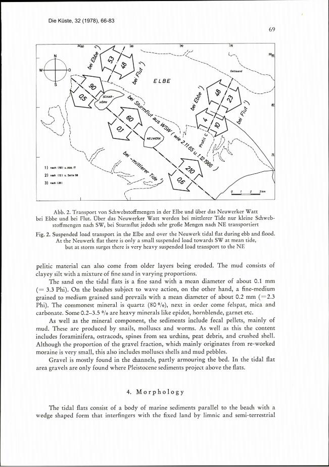
Im Verein von Tidestrdmungen und Seegang werden grole Schwebstoffmengen im
Watt transportiert. Messungen im Neuwerker Wart ergaben Suspensionskonzentrationenvon 30 mg/1 far die ungestilrte Tide; 100 mg/1 wurde im Mittel von 1500 Messungenam li ufigsren gemessen und 300 mg/l fur eine Sturmfluttide. Wird dabei die unterschied-liclie Oberstr6mungsriclitung und Uberstrdmungsmenge eines Watts berlicksichtigt, so
steigt (let, Suspensionstransport bei Sturmfluten um zwei bis drei Zehnerpotenzen(Abb. 2).
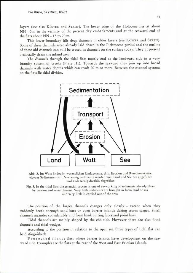
Die heutigen Watten bekommen nur wenig neues Sediment zugefiihrt. Die meisten
Sedimentbewegungen finden innerhalb des Watts in Form von Umlagerung statt
(Abb. 3).Die Wassertemperaturen der Wasserkllrper, weIche die Watten uberfluten, schwan-
ken stark und sind an die Schwankungen der Lufttemperatur gebunden. Ahnlich starkschwankt der Salzgehalt in den groilen Meeresbuchten, wo bei trockenem Wetter im
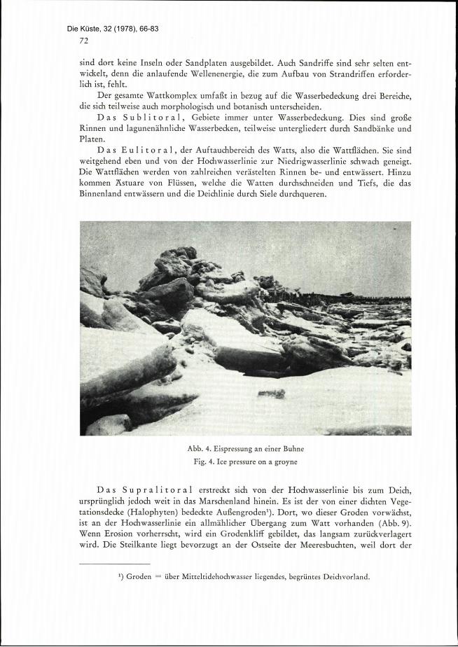
Sommer der Salzgehalt iiber den der freien See steigen kann. Im Winter kuhlen dieWatten stark ab, so daB dorr die erste Eisbildung erfolgt. Bei starken, auf das Land
geridlteten Winden kommt es zu Eispressung, die Bauwerken gef rlich werden kann
(Abb. 4).
3. Die Sedimente
Die Sedimente stammen vorwiegend aus aufgearbeiteten glazialen Sedimenteii. Da-neben werden geringere Anteile - vor allem pelitische Fraktionen - von Flussen heran-
Die Küste, 32 (1978), 66-83
The Tidal Flats on the German North Sea Coast
By Hans-Erich Reineck
1. Location
The Soutli and in part the East coast of the North Sea are bounded by tidal flars
They stretch for a total length of 450 km along the Netherlands, German and Danish
coasts. The tidal Rats of the southern North Sea are of an average width of 5 to 7 km
with a maximum of 10 to 15 km. They are intersected by rivers and numerous creeks
(Plate III).
2. Hydrography and Sedimentation processes
The rides are semidiurnal. The spring ride range lies around 2.6 m with a maximum
of 4.1 m in the Jade bay (Jadebusen). Neap ridal range is 1.8 m widi 3.1 m in the
Jadebusen. The tidal currents over the flats reach velocities of 30 to 50 cm/sec., with a
maximum (at storm surges) of 150 cm/sec. In smaller channels the current velocities
are about 100 cm/sec. (Fig. 1) and in large channels about 150 cm/sec.
Wave movement is a very important factor. It comes from various directions
and with changing strength. Nevertheless, the predominant movement is from the we-
stern sector. The wave movement over the tidal flats is the major factor influencingthe distribution of sediments, and erosion and sedimentation.
Tidal currents and wave movement combine to transport large quantities of
suspended load over the tidal Eats. Measurements in the Neuwerk flat gave concentra-
tions of suspension of 30 mg/1 for a calm tide; of 1500 measurements the most frequentmean value was 100 mg/1 and 300 mg/l was reached on a storm flood tide. If account
is also taken of the shifting direction and volume with which tlie tide flows over the
Hats the transport of sediments during storm surges rises by two to three orders of
magnitude (Fig. 2).The present day tidal flaIS receive very little new sediment from outside. Most
sediment changes take place within the flats in the form of rediStribution (Fig. 3).The water temperature of the body of water which inundates the flars fluctuates
greatly and is related to fluctuations in air temperature. In the same way the salt con-
tent in the large marine bays also varies, so that iii dry summer weather the salt content
can rise higher than that in the open sea. In winter the flats cool very much, so thatthe first ice forms here. When there are strong winds blowing in a landward direction
there can be ice pressures which can enda.nger engineering structures (Fig. 4).
3. The Sediments
The origin of these is predominantly re-worked glacial sediments. In additionthere is a smaller proportion - especially pelitic fractions - brought down by rivers, but
Die Küste, 32 (1978), 66-83
68
Schaufelradstrommessung in einer Balje
V
[cm/s]
100
001
90. -
1800 -
2700
360°
Waftstrommessung auf finer Waltwasserscheide
V
[cm/s]
100
0. 1
90.
180°-
270° -
3600
1 1 0*
- 900
- 1800
- - 2700
3600
Abb. 1. Kurven von Tidestromgeschwindigkeit und Stromrichtung nach Messungenin einer Balie und auf einer Wattwasserscheide
Fig. 1. Curves of velocities and directions of tidal currents in a Balje (channet) andat a tidal flat watershed
0.
- 900
180.
2700
3600
DAUERSTROMMESSUNGEN VOR DER WURSTER KUSTE
PN
[cm]
Wasserstald 600
80 500
5 trom geschwIndigkelt
Flut Ebbe60
40 400
20
0 300
looe 1200 130° 14°e 15,0 16.. 1700 1800 1900 200° 2/ 220°
1,
f- \-
.lr.mr
P"
Icm]
Waiserstand600
80 500
60
40 400
Stromgeschwindlgk/HFlut Ebbe
20
Gerot stehl trocken Gerot stehl trocken0i 300
10go l 2°° 1]00 14°° 15°° 1600 1700 1800 1900 20°° 2100 22°°
Stromrtch/ung
Die Küste, 32 (1978), 66-83
69
- r---/7/f \3
rt-3 3 <\ i L
\J /
5<
-\:Espi1, I.,49'..A='D
2) na (123 ..S,it, m
31 nia 1281
*e '1 -1 /I= 1 IS
N 4<47.*-
\-- 1# 1 .7
w 0 AL*j, =-=............ e'l,„e, .....=.-=-K-F--7.-4 >'7 E L BE 2
---
S ) ><. ·10+
=-p*/ \. =..*....c \-l = '%2,/\ 45\ 7%*
r23*Efi:.Virffidis.....1.-Jili;%#rir.*art\ f 'r,
\ NEUWRI l 44 . ; TO ........ \4* 44 ,/''t , 1, .....\0 ./ 7-14244 'CZ' \\i
4% i.\\\
NWL- 6 .3''A J
=4*3= t.#i : r.er f V.
1 \ 1 1:/
Abb. 2. Transport von Schwebsto£fmengen in der Elbe und iiber das Neuwerker Watt
bei Ebbe und bei Flut. Ober das Neuwerker Watt werden bei mittlerer Tide nur kleine Sdiweb-
stoffmengen nach SW, bei Sturmflut jedoch sehr grolle Mengen nach NE transportiert
Fig. 2. Suspended load transport in the Elbe and over the Neuwerk ridal flat during ebb and fiood.
At the Neuwerk flat there is only a small suspended load towards SW at mean tide,but at storm surges there is very heavy suspended load transport to the ATE
pelitic material can also come from older layers being eroded. Tlie mud consists of
clayey silt wirh a mixture of fine sand in varying proportions.The sand on the tidal flats is a fine sand with a mean diameter of about 0.1 mm
( = 3.3 Phi). On the beaches subject to wave action, on the other hand, a fine-medium
grained to medium grained sand prevails with a mean diameter of about 0.2 mm (-2.3Phi). The commonest mineral is quartz (800/0), next in order come fetspat, mica and
carbonate. Some 0.2-3.5 0/0 are heavy minerals like epidot, hornbiende, garnet etc.
As well as the mineral component, tile sediments include fecal pellets, mainly of
mud. These are produced by snails, molluscs and worms. As well as this the content
includes foraminifera, ostracods, spines from sea urchins, peat debris, and crushed shell.
Although the proportion of the gravel fraction, which mainly originates from re-worked
moraine is very small, this also includes molluscs shells and mud pebbles.Gravel is mostly found in the channels, partly armouring the bed. In the ridal flat
area gravels are only found where Pleistocene sediments project above the Hats.
4. Morphology
The tidal Rats consist of a body of marine sediments parallel to the beach with a
wedge shaped form that interfingers with the fixed land by limilic and semi-terrestrial
Die Küste, 32 (1978), 66-83

gebracht, aber auch aus lzeren erodierten Schichten kdnnen Pelite kommen. Schlick be-steht aus tonigem Silt mit Beimengungen von Feinsand in unterschiedlichen Mengenver-hiltnissen.
Der Wattensand ist ein Feinsand mit einem Md um 0,1 mm (- 3,3 Phi). An den
Brandungsstrdnden dagegen herrschen feinsandige Mittelsande bis Mittelsande vor miteinem Md um 0,2 mm (= 2,3 Phi). Das h ufigste Mineral ist Quarz (80 %), nachgeord-net sind Feldspite, Glimmer und Karbonate. 0,2-3,5 % sind Schwermineralien wie
Epidot, Hornblende, Granat u. a. m.
Die Sedimente enthalten neben den mineralischen Komponenten Kotpillen, vorwie-
gend aus Schlick. Produzenten sind Schnecken, Muscheln und Wurmer. Weiterhin sindenthalten: Foraminiferen und Ostiacodengeh use, Stacheln von Herzigeln, Torfgrus undBruchschill. Gering ist der Anteil an der Kiesfralition, die vorwiegend aus aufgearbei-teten Morinen stammt, die aber auch Muschelklappen und Schlickger8lle enthilt.
Kies ist meist iii den Rinnen vorhanden, z. T. als Sohlenpflaster. Auf Wattfl chenist Kies nur dort zu finden, wo kiesige Sedimente des Pleistozdns aus dem Watt heraus-
ragen.
4. Morphologie
Die Watten stellen einen uferparallelen marinen Sedimentk8rper dar mit keilfdr-
miger Gestalt, der zum Festland hin mit limnischen und semiterrestrischen Schichtenverzahnt ist. In der Gegend der heutigen Deidie liegt die Untergrenze des Holozins beietwa -5 m NN und an der Seeseite bei etwa 15 bis 20 m unter NN.
Diese Untergrenze fullt tiefe Rinnen in Alteren Schichten. Einige dieser Rinnen sindschon im Pleistoz n angelegt und als ]linnea noch heute an der Oberfliche „durchge-paust". Sie entwlissern z. T. kiinstlich das Binnenland (Tiefs).
Die Wattrinnen enden zum Land hin meist in einem stark veristelten Priel-
system (Tafel III). Nach See sd lieBen sie sich zu mbichtigen Rimien zusammen mit Was-
sertiefen, die 20 m und mehr erreidien klinnen. Zwischen den Ri nensystemen im Watt
liegen Wattwasserscheiden.
Die Lage grofier Rinnen wediselt nur langsam - auBer bei platzlichen Durchbrii-chen von Sandbarren oder gar Diineninseln. Kleinere Rinnen miiandern betr chtlich undbilden Prall- und Gleith nge aus.
Die Wartrinnen sind vorwiegend vom Ebbstrom geprdgt. Daneben kommen aberauch Flutstromrinnen und Flutstromhaken vor.
Nach der Lage zur offenen See kann man 3 Watt-Typen unterscheiden:
Riickseitenwatten: Watten, an deren Seeseite Diineninseln entwickeltsind. Beispiel sind die Watten hinter den West- und Ostfriesischen Inseln.
Offene Watten: Watten ohne seeseitigen Schutz durch Duneninseln. Beispiel:die Watten zwischen Weser und Elbe bis ndrdlich von Sylt. Diese Watten haben einen
sehr flach geneigten Unterwasserhang. An der Seefront sind teilweise unter und iiber derNiedrigwasserlinie fast strandparallele Strandriffe, wie an den Strdnden der Dunen-
inseln, entwickelt. An der Hochwasserlinie kommt es zu flachen Sandplaten mit An-
zeichen von Windtransport wie Primardiinen, ohne dab jedoch stabile Inseln darausentstehen.
Wattenin Buchtenund Astuarien,z. B. Dollart, in der Jade und
in der Weser- und Elbmundung. An der Niedrigwasserlinie sind sie zwar sandig, jedoch
70
Die Küste, 32 (1978), 66-83
layers (see also K TER and STREIF). The lower edge of the Holocene lies at about
NN -5m in the vicinity of tile present day embankments and at the seaward end of
the Rats about NN - 15 to 20 m.
This lower boundary fills deep channels hi older layers (see K, STER and STREIF).Some of these channels were already laid down in the Pleistocene period and the outline
of these old channels can still be traced as channels on the surface today. They at present
artificially drain the inland area.
The channels through tile tidal fiats mostly end at the landward side in a very
branchy system of creeks (Plate III). Tgwards the seaward they join up into broad
channels with water depths which can reach 20 m or more. Between the channel systems
on the flats lie ridal divides.
r-- -1
i SedimentationL- -J
---- -----
/r-------7
LTfansport -
/ -7
Erosion 1
'7-/-\
Abb. 3. Im Watt findet im weseniliclien Umlagerung, d. h. Erosion und Resedimentation
eigener Sedimente start. Nur wenig Sedimente werden von Land und See her zugefuhrtund audi wenig dorthin abgefulirt
Fig. 3. In the tidal Rats the essenrial process is one of re-working of sediments already there
by erosion and re-settlement. Very little sediments are brought in from land or sea
and very little is carried out of the area
The position of the larger channels changes only slowly - except when theysuddenly break through sand bars or even barrier islands during storm surges. Small
channels meander considerably and form bank Cutting faces and point bars.
Tidal channels are mainly shaped by the ebb tide. However there are also flood
channels and tidal wedges.According to the position in relation to the open sea three types of tidal flat can
be distinguished:Protected flatS: flats where barrier islands have development on the sea-
ward side. Examples are the flats at the rear of the West and East Friesian Islands.
71
--- -- --
11
--
--
Land Watt See
Die Küste, 32 (1978), 66-83
sind dort keine Inseln oder Sandplaten ausgebildet. Auch Sandriffe sind sehr selten ent-
widielt, denn die anlaufende Wellenenergie, die zum Aufbau von Strandriffen erforder-
lichist, fehltDer gesanite Wattkomplex umfaEr in bezug auf die Wasserbedeckung drei Bereiche,
die sich teilweise auch morphologisch und botanisch unterscheiden.Das Sublitoral, Gebiete immer unter Wasserbedeckung. Dies sind groBe
Rinnen und lagunenihnliche Wasserbecken, teilweise untergliedert durch Sandbb:nke und
Platen.
Das Eulitoral, der Aufrauchbereich des Watts, also die Wattflichen. Sie sind
weitgehend eben und von der Hochwasserlinie zur Niedrigwasserlinie schwach geneigt.Die Wattflichen werden von zahlreichen verbtelten Rinnen be- und entwissert. Hinzu
kommen Astuare von Flussen, welche die Watten durchsclineiden und Tiefs, die dasBilinenland entwissern und die Deichlinie durch Siele durchqueren.
.A 2415.Cr.* .e-
5 ...a'*. 1/1//45..'4.21. ,
,
"*- .6. I
-lf
3
....
f..)
Pe"W,
8** ., /*/, 1
.........
... 4.
Abb. 4. Eispressung an einer Buhne
Fig. 4. Ice pressure on a groyne
/7-Yi-
Das Supralitoral erstreckt sich von der Hochwasserlinie bis zum Deich,ursprunglich jectoch weit in das Marschentand hinein. Es ist der von einer dichten Vege-tationsdecke (Halophyten) bedeckte AuBengroden'). Dort, wo dieser Groden vorwkichst,ist an der Hochwasserlinie ein allmRhlicher Ubergang zum Watt vorhanden (Abb. 9).Wenn Erosion vorherrscht, wird ein Grodenkliff gebilder, das langsam zuriickverlagertwird. Die Steilkante liegt bevorzugt an der Ostseite der Meeresbucliten, weil dort der
D Groden = uber Mitteltidehochwasser liegendes, begruntes Deictivorland.
72
. , 4. : .flf .:I. '.·· •: ':·'·4*·"
4 47· j ,· ·· ':...;.'.F -T . 7 : ......' *i'.,
fl· ··.r' ··''. ·· 4 .. 1 . -i, ly, '.Ii., ...6.
1..
. ''..'.I
L.%
..'
c ..:k'...*-0.-
.
Die Küste, 32 (1978), 66-83

42..
6* :f ·
:ik.4'
I.,: '
: - -
-*, 4 ·# · ·· ·' 'lp:f*w..b.,- 1 I::069 . L..
v.•r'.·, .
.. 4454#.
Abb. 5. Luftbild eines Sandwatts mit Sandwellen
Fig. 5. Aerial photograpli of a sand f at with sand waves
Open flats: flats with no protection on the seaward side from barrier islands ;
for example flats between the Weser and Elbe up to the north of Sylt. These flats have
a very flat underwater slope. On the seaward side are longshore bars almost parallelto the beach, partly above and partly below the low water line, similar to those developedon the beaches of the barrier islands. At the high water line shallow shoals develop with
signs of wind transport like primary dunes, which do not however become Stable islands.
Flats in Bays and Estuaries: e.g. in the Dollart, the Jade, and in
the outer Weser and Elbe estuaries. Although these are indeed also sandy at the low
water mark this does not lead to the formation of islands or shoals. Neither do sandbars
often develop since the energy of the incoming waves whicti is necessary to build sand-
bars, is lacking.The overall tidal flat complex comprises three different areas as far as water cover
is concerned which have some morphological and botanical differences:
The sub-tidal area is always covered by water. These are large channels
and lagooIi-like pools of water, partly sub-divided by sandbanks and shoals.
The inter-tidal area, the drying stretch of the tidal flats. They are
mainly flat and slope gently from the high to the low water line. The tidal flats are
flooded and drained by numerous branching channels. In addition to this, river estuaries
cut througli the flats, and creeks drain the inland area through sluices in the dykes.The supra-tidal area extends from the high water mark to the foot of
the embankment, though originally it stretched far back into the marshland behind.
The 'Groden'l) is carpeted with vegetarion (halophytes). At the edge of these Groden
or Saltings there is a gradual transition to tidal lats at the high water line (Fig. 9). In
periods of erosion a marsh cutting face is formed which moves slowly landward. The
1) Groden - the saltings in front of an embankment above high water
73
t
r..':i t. I
Die Küste, 32 (1978), 66-83
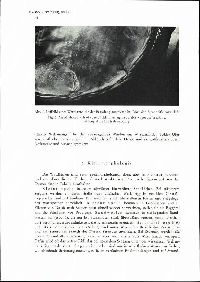
Abb. 6. Luftbild einer Watrkante, die der Brandung ausgesetzt ist. Dort sind Strandriffe ennvickek
Fig. 6. Aerial photograph of edge of ridal flars against which waves are breaking.Along shore bar is developing
stirkste Wellenangriff bei den vorwiegenden Winden aus W stattfindet. Solche Ufer
wai·en oft iiber Jahrhunderte im Abbruch befilidlich. Heute sind sie gr6Btenteils durch
Deckwerke und Buhnen gesdiutzt.
5. Kleinmorphologie
Die Wattfilichen sind zwar grohmorphologisch eben, aber in kleineren Bereichen
sind vor allem die Sandfl chen oft stark struituriert. Die am li ufigsten auftretenden
Formen sind in Tabelle 1 entlialten.
Kleinrippeln bedecken schwi:cher uberstr6mre Sandfli:chen. Bei stirkerem
Seegang werden an deren Stelle oder zusitzlich Wellenrippeln gebilder. GroE-
rippeln sind auf sandigen Rinnensohlen, stark uberstr8mten Platen und tiefgelege-nen Wattspornen entwickelt. Riesenrippeln kommen in Grolirinnen und ill
Flussen vor. Da sie nadi Baggerungen schnell wieder aufwachsen, stellen sie die Baggereiund die Schiffalirt vor Probleme. Sandwellen kommen in tiefliegenden Sand-
watten vor (Abb. 5), die nur bei Sturmfluten stark uberstr6mt werden; sonst herrschen
dort Strdmungsgeschwindigkeiten, die Kleinrippeln erzeugeii. Strandriffe (Abb. 6)und Brandungsbanke (Abb. 7) sind unter Wasser im Bereich des Vorstrandesund am Strand im Bereich des Nassen Strandes entwickelt. Bei Sturmen werden die
oberen Strandriffe eingeebnet, teilweise aber auch weiter aufs Watt hinauf verlagert.Daftir wird oft das untere Riff, das bei normalem Seegang unter der wirksamen Wellen-
basis liegt, reaktiviert. Gegenrippeln sind nur in sehr flachem Wasser zu finden,wo schieBende Str6mung entsreht, z. B. an verflachten Prielmundungen und auf Strand-
74
Die Küste, 32 (1978), 66-83

141 1 .a
5 71 .M G .53-3 j
E- 80: 5B -0 F
97 3-2
#3 *5:1le -0 V
55 MU.i.84328..< -.·
04 e#91 C : -0
3-0 S.E . 0
08 4a ·E %8 44 .0.
':3' Ta41.58 a
.E,-6 :2-9 5 .
O bOP
lie SM ES :2 g
*3 4<0 43 m4 4
.E
m%0
E&:05802
bo X215 In
m Rd10:§1111=10 0,4
* t·:58 E
EK.
.
%Ma m
.
8a*
li
-# pE-.-
tb
BE
Eanm
B8@'04
11 H
I.-4
U
E :%3 U 'r,
:#4lau >k
I# 3.E.5RE me
EE217 2\DO
H Il
%,-1
3 9-
a.1 M.il2 1 22.8 Z * F.8
.= ==..- = = "
343-=*1<3 -.* W- 40.5 .9 be- .f -5
E.B.W.m3 E.".*B f%24% 8 -22. .§1 39 #113% ala: 3 C f &; 3 2.2
a .9
IM .S:42 WIF!# M .2
. . E.E = :m1 & 8 EA.e
4430
23Y%,5 5.#32 & 8MgA4
.
-%1.C=d
JW& 8.St
31 20 U
22 6 4 -f2 le C .
'imis4.E B m
135%
1 . -
iile la% 7E 28
A..
ElEO58Ai+ rr
H 11
%,4
/8 335MM
4 2
g
W.9 E:*%gB*--
"
11.a.M5
..0 Fe
m a.9 1/0 PQ 4 -
9/2 /glmP:1=/ e
134- 6-,
M M� 4
./
A* :
1/1 2 +MImm Sk NE th9 U / 3 45.9 2f E - : i
% § 4 K !! M
14 8 0:> 2%
-3
3 E38418 E..m.5E-beKE% t:2882= *
13..
Em de
'. 28 . I
H ng /,1 i, i21 M M *4* N B S B
6 1118§* ES sBu Eu.BEam!|11Mlill 81|IIEII!1 Heuo 68& § . .i! a.M M *.. . *.M:§ 3 1/9 9 77
11 8*4455 8.3 =, *53 11 99 enIllilla 11Elills uEEillian H 113;*S: :2%00 % *4%00 7 4 j g 4
Z3*U
P.Q g
* &14 :M2. w 2 2%21-I (-0 e e
14 91 100*.a bo
#i.-.-
"B1E
gl
411%4
iMP**223 :4 aam-O-0 .. 60 =
m & E# 8 1.(')0-ov
114 5bU
%i:3aa
31 R400- 4 0.21S Ji 8 -ias ELEE g
.d
Hta 414.8 .# rf
1 Wipo 2
3 4151& E e·-a5 =.2.9'5,90%4.2 % /56.2,"
-0
ad434.E d..'
WiEP
43 -
·2 8'1 7/:·2.5.5m -# M %A-2; A k
AMJEF;
I .. .
M M0 3
1 0
3.§'3C'82
3
Die Küste, 32 (1978), 66-83

Abb. 7. Die Insel Scharharn in einer Lutibild-Schrigaufnahme. Im Vordergrund cinehauptsachlich durch Brandung auf Schai·harn zu verlagerte Brandungsbank
Fig. 7. The island of Scharhorn in an oblique aerial photograph.In the foreground a slioal mainly built up by wave action which has moved towards Scharh6rn
.
_
·· I. ...rE zE' -- ·-:4%;;'w-
.
-
- ·- --··*-=ZEL.3-i:=ZLX.::.**S'•* 7-1- Z:
--
........
-
, .* i -.-I
.2=... .4.- :Itul. 1.--... :..- .-
U/.-52,- --
.*I -'
..,-tf-*-.-Il.# 11
*47-6-1
-
..7. 4//rze:../.#. ../219/*
-*r· .-4/'f ·r
-_... 1:/0
.-
Ej#&324'- -LF-·- -
.fft- 6 -- .. -
** il. f
I. 4-1-E:2"*ti%......... *i *.4....
-
Abb. 8. Schlickwatt mic stark mRanderndem Priel. Im Vordergrund eine gr ere Wattrinne
Fig. 8. Mud flat with strongly meandering creek. In the foreground a large tidal channel
76
.....,-
r
r--
-
5.- +&.r
Die Küste, 32 (1978), 66-83
steep slope tends to favour the east side of rhe sea bay as with the prevailing winds from
the west The waves attack most strongly on tllal: side. Such curring faces oRen went on
eroding for centuries. Nowadays they are mostly protected by paving and groynes.
5. Micro-morphology
Although the macro-morphology of the tidal Rats is level, in small areas, especiallyin sandy stretches, they are often considerably structured. The most commonly met forms
are included in Table 1.
Small current ripples cover sand areas covered by weak currents. With
heavier seas wave ripples replace them or are added to them. Mega ripplesdevelop on the sandy beds of channels, on shoals subjected to heavy currents, and deeplying spurs of the tidal Gats. Giant ripples occur in large channels and rivers.
As they develop very rapidly after dredging, they present problems for dredging and
shipping.Sand waves arise in deep lying sand flats (Fig. 5) which are only sub-
jected to heavy currents during storm tides; at other times the prevailing flow velocities
produce small ripples.Long shore bars (Fig. 6) and shoals (Fig. 7) develop
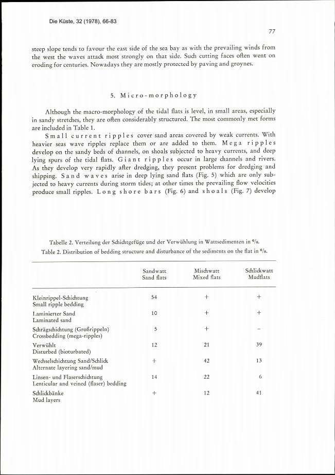
Tabelle 2. Verteilung der Schidltgefuge und der Verwahlung in Wattsedimenten in 0/0.
Table 2. Distribution of bedding structure and disturbance of the sediments on the £lat in 0/0.
Kleinrippel-SchichtungSmall ripple beddingLaminierter SandLaminated sand
Schrigschiditung (Grogrippeln)Crossbedding (mega-ripples)
VerwuhltDisturbed (bioturbated)
Wediselschiclitung Sand/Schlick
Alternate layering sand/mud
Linsen- und FlaserschichrungLenticular and veined (flaser) beddingS lickbinkeMud layers
SandwattSand flats
MischwattMixed flats
SchlickwattMudflats
77
54 + +
10 + +
5 +
I2 21 39
+ 42 13
14 22 6
+ 12 41
Die Küste, 32 (1978), 66-83
78
-9
12;**,2· t *RA:J.fis %* t.·2: re Q=-,/4..i.,6,31 .,A··.*.,5* -..4 ·A *.
·
,···.'' A 4.r 1 . ' ,..t f d: .. '..ft. -17('*,-,(&· ;:'7 4.r.7454544*614&t 4621(„,_· .* 211 , *2' , ·' -'04*.> +
.6. .·-t /':7•1..=-*..::.i ·.- .'.-*' ..4 1. - 1.M I .' i f .3,
- · 2/6 .j :1:*** . . kh... *1 1. Ll 4 =7,- -=
----.-'....'.,-4 t.6. -
.... . ..lillI-/-.-. ... I r.-, ........ML:-: ... ... :... .. B
M/firm&Weon- I..'.. .. 1 2 .r .. ".
&,9#7 / 1:,t.7:,·...:27</A : - 1-.- ..' .:
---. :... .
-....
'1029<-b'.I. *..... &............- ":*'... 6.*aigt 1 *A#,r : -3,3:-:: AFA .........,=--. '.-... r ..'-S* Ip-41/&4.. '.... -:'...Y: /2:<-6.......'..... I.
.·:· -'· ·
' · · 4/ -
.'*·7' *'**'* W (431:.:..:·fs..4. .....:'.<··.9 2.4:--M:4:.Ecrz 55*4'#tdiqb*>6' C·t...3. · ·,:··:4' · '-bp ·-·" -Qt·fAAillikdat,6Ii i ·:··,:,c J..- 2"/ti'/9/,7#44/4,95£ A.Ue:.:7...:,:.:-':4...1.......5 -r'. ....
.
...A#.2#,PF 32*26<742.'·:....#3.,:'....6. f.&·.. -. R.,.,9.,6,7 t:-.·:.:..2.,· -
·Yfa....r...9.*," t''4...Ae* I.-r :....7... 2£fuls#+A:<...9 -
2.M."Cf : 41 1:E :.4...St . .....,......: ..:, 4..3,-·-,k/,2.L.:,
' 241 - ··:,a· ·* ....·f·<.- ,.. -,·
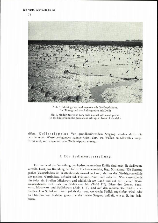
Abb. 9. Schlidcige Verlandungszone mit Quellerpflanzen.Im Hintergrund der AuBengroden mit Deidi
Fig. 9. Muddy accretion zone with annual salt marsh plants.In the background the permanent saltings in front of the dyke
riffen. Wellenrippeln: Von grundberuhrendem Seegang werden durch dieoszillierenden Wasserbewegungen symmetrische, dort, wo Wellen zu Schwallen umge-formt sind, auch asymmetrische Wellenrippeln erzeugr.
6. Die Sedimentverteilung
Entsprechend der Verteilung der hydrodynamischen Krdfie sind auch die Sedimenteverteilt. Don, wo Brandung der freien Flachsee einwirkt, liegt Mittelsand. Wo Seeganggrolier Wasserfllichen im Wattenbereich einwirken kann, also an der Niedrigwasserlinieder meisten Wattflichen, befindet sich Feinsand. Zum Land oder zur Wattwasserscheidehin folgt ein Streifen Mischwatt und schlie£lich am Land und auf den meisten Watt-wasserscheiden zieht sich das Schlickwart hin (Tafel III). Diese drei Zonen, Sand-rvatt, Mischwatt und Schlidwatt (Abb. 8,9), sind auf den meisten Watdichen vor-
handen. Das Schlickwart setzt jedoch dort aus, wo wenig Schlick angeliefert wird, oderan Ostufern von Buchten, gegen die der meiste Seegang anlKuft, wie z. B. im Jade-busen.
Die Küste, 32 (1978), 66-83
in the area in front of the beach and on the beach itself on the foreshore (between highand low water). During storms the upper sandbars are levelled, although to some extent
they are also shifted further up the tidal flat. The underlying bar which under normal
conditions lies below the effective wave movement is reactivated during such storms.
Anti-dunes are only to be found in very shallow water, where shooting flow oc-
curs, e.g. at the flarrened mouths of the creeks and on long shore bars. Wave rip-
ples: wave moveme,its close to the bed produce symmetrical ripples through the OSCil
laiing water movement. In places where the waves are deformed into surges, asymmetricatripples are also produced.
.
, 3%13,4+
Abb. 10. Stark verwahlter Wattboden (RetiefguE einer ungest6rten Sedimentprobe)
Fig. 10. Very disturbed sediments from a tidal flat (Peels with high relief of an undisturbedsediment core)
6. The distribution of sediments
The sediments are also distributed in line with tile distribution of hydrodynamicforces. In areas where the waves are acting on open coastal waters the bed is medium
sands. There are hne sands where wave movement over relatively large open areas of
water is affecting tile ridal flat. Towards the landward or up to the watershed there
follow a strip of mixed Rats and finally nearest the land and on most of the watershed
79
.
Die Küste, 32 (1978), 66-83

80
//.., 9
e : -7 --r,
27-i
F:-*- -
./ ·.*//-9....-ri-- s--.
*+
. AZ:*02/r=*641...h-Ull- ..-
El--Il. /.91---
- 16-2 --
' .
7 ..'L.,Lf.. / g '\24 -
.: .%32,7.48,.< a.. ..
*defAA)64*f#75 =- . ..=.1,*.....
Abb. 11. Reusen 'n einer Wattrinne
Fig. 11. F'sh baskets in a ridal channel
7. Die Gef iige
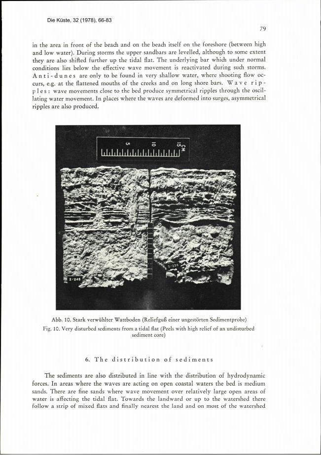
1 1
Die Sand- und Schlickvorkommen weisen innere Gefiige auf. Einmal sind es pri-mlire Gefuge mit physikalischem Ursprung (Tabelle 2). Daneben gibt es auch zablreiche
biogene Gefuge (- Wuhlgefuge) (Abb. 10).Feinblittrige Wediselschichtung, Flaser- und Linsenschichtung entstehen durch den
tidegegebenen Wechsel zwischen Tidestrbmungen (- Sandtransport) und Stauwasser-
zeiten ( = Schlickabsatz) (Abb. 1).
8. Der Lebensraum Watt
Auf den Watten leben vorwiegend Polychaeten, Muscheln, Schnecken und Krebse
sowie eine Vielzahl winziger Ein- und Melirzeller, wie z. B. Diatomeen und Foramini-
feren. Die meisten der Makroformen leben im Wattenboden. Hinzu kommen Ebbgaste,wie Vagel und Insekren und Flutgkiste, wie Fische, Krebse, Quallen, Seesterne und
Planktoil. In der Verlandungszone wird die Vegemtion dichter und Iiber MThw serzt
eine geschlossene Vegetationsdecke von Halophyten ein (Abb. 9).Die Wattbewohner uben einen gewissen Einflu£ auf die Wattsedimente aus: Eine
Reihe von Suspensionsfiltern erzeugen Korpillen, durch welche es zu Schlickanreicherun-
*,
<- 746-. .-: M.7.*
.'
TE--i
-
--2.*.*I
*t...4:
rs=-Pit
2%52%-=i- --*4%=ar>2.2.-r -:--
=*e:-
Die Küste, 32 (1978), 66-83
/4, Z
44't . ..„i.
..., ..'''
I
4.
4 4:, 4 4'
5 '4,
i
. 244*I
=
:.2 F
LA#..4.
*..1*"4.9* t *00
..'62.
-immE'.- ' .....0,7-, -
fi*-
4 .. 17-9..g,6.-4..4.-I ..Prmi" I.*Al.'3 i
.- s"£f*R)'*
-***h //.:
i.C..44.*m=-
.'.,40 4 10-*
, 4161£.183Tafel VIII: Insel Amrum am Westrand des Wattenmeeres mit breitem Diinengurtel und vorgelagertem
Aulensand (vorn links). Im Osten Geest- und Marschlandereien. (Aufn. U. MuuB)
Plate VIII: The island of Amrum along the western edge of rhe inter-ridal zone, with a broad belt of dunesand an outer sand in front, which can be seen in the foreground on the left. On its eastern side there are
areas of diluvium and of saltings.
4:,
--.0-
Die Küste, 32 (1978), 66-83
Stretches: the mud Hats (Plate III). These three zones, sand flats (Fig. 7), mixed flats and
mud lars (Fig. 8,9) are found on most tidal Rats. There is a break in the mud flats,
however, in areas where little mud is deposited, or on the east side of bays, which is most
exposed to wave action as in rhe Jade Bay.
7. The structure
The sandy and muddy areas display internal structures. Some of these are primarystructures with physical origins (Table 2). In addition there are numerous biologicalstructures (bioturbate structures) (Fig. 10).
Thinly inter-layered bedding, flaser (veins) and lenticular bedding (Fig. 1) are
formed through the laminating action of the changing tide between the tidal currents
(sand transport) and slack water (deposit of mud).
8. The tidal flat habitat
Polychaeres, bivalves, gastropods, and shrimps are the main inhabitants of the tidal
flats together with a great number of tiny unicellular and multicellular forms such as
diatoms and foraminifers. Most macro forms live in the soil of the flat. There are also
visitors on the ebb tide such as birds and insects and on the flood tide such as fish,crabs, jelly fish, star fish, and plankton. In the accretion zone the vegetation becomes
denser and above HWMT there is an unbroken carpet of salt tolerating vegetation(halophytes) (Fig. 9).
The creatures living on the flat have a certain influence on the sediments in it.
A series of suspension feeders produce fecal pellets which can enrich the mud. There are
particularly large numbers of the mussel Mytilas ed;dis. A great many other creatures
such as Polychaetes etc. produce fecal pellets wliich behave in the same way as sand
grains as regards sediment transport and often account for a large part of the mud
content of the sand.
A skin of diatoms can fix the top surface of the flat in a slimy algal mat. The
many burrows of the mud shrimp Coropbium on rhe other hand, so perforate the highlying Cutting faces of the marsh that they are easier to erode. The vegetation in the
zone of deposition, particularly salicornia, encourages deposition as the mud serrles there
more thickly.Tlie decaying organic substance essentially contributes to tlie formation of the
"redox" zone. The topmost millimetre to centimetre of the flat is oxygenated, a layerof soil lying below about a decimerre thick is anaerobic. This can often be recognised from
its blue-black colour.
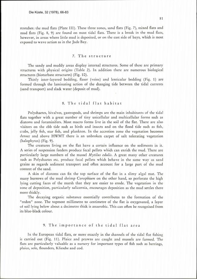
9. The importance of the tidal flat area
In the European tidal flats, or more exactly in the channels of the tidal flat fishingis carried out (Fig. 11). Plaice and prawns are caught and mussels are farmed. Tlie
flats are particularly valuable as a nursery for important types of fish such as herrings,plaice, sole, flounders, Klies<he and cod.
81
Die Küste, 32 (1978), 66-83
gen kommen kann. Es ist dies in besonderem MaBe die Muschel Mytilus edulis. Aber
auch zahlreiche andere Tiere, wie Polychaeten usw. produzieren Kotpillen, die sicli beim
Sedimenttransport Khnlich wie Sandk6rner verhalten und oft einen grolien Teil des
Scilickgelialts in Sanden ausmachen.
Diatomeenhdute k6nnen die WattoberfiRche dutch einen dunnen Schleimteppichfestlegen. Die zahlreichen Bauten des Schlickkrebses Corophium vermdgen dagegenhochliegende Kleikanten so zu durchldchern, daB sie leiditer abgetragen werden k8nnen.Die Vegetation der Verlandungszone, vorwiegend der Queller, £8rdert die Verlandungdadurch, daE sich dort Schlick stirker absetzt.
Die zerfallen(le organisclie Substanz trigt wesentlich zur Ausbildung der Redox-
zone bei. Die obersten Milli- bis Zentimeter des Watts sind oxidiert; eine darunter
liegende Bodenschicht von Dezimeter-Michtigkeit ist reduziert, was an der oft blau-
schwarzen F rbung erkennbar ist.
9. Die Bedeutung des Wattenraumes
In den europdischen Watten, genauer in den Wattrinnen, wird Wattenfischereibetrieben (Abb. 11). Es werden vor allem Garnelen und Schollen gefangen; danebenwird Miesmusdielzucht betrieben. Von grofier Bedeutung ist das Watt als Kinderstubefiir so bedeutende Arten wie Hering, Scholle, Seezunge, Flunder, Kliesche und Dorsch.
Das Watt hat zudem groBe Bedeutung als Naturraum und als Erholungsgebiet. In
bgzug auf das Binnenland und den Deich ist das Watt scliutzendes Vorfeld. Durch Ver-
landung war es mtiglich, im Laufe der Geschichte zahlreidie, durch Meereseinbruche in
das Land eingerissene Buchten wieder zum Festland zuruckzugewinnen.
82
Die Küste, 32 (1978), 66-83

In addition the tidal Rats have great importance as a nature reserve and a health
resort. In relation to the inland area and the embankment The Hat acts as a protectiveforeshore. Deposition on the flats has made it possible to win back to the land many
stretches which had previously been washed away when the sea broke through.
l
83
Die Küste, 32 (1978), 66-83