Embed Size (px)
Citation preview
7,5 €/m ² SF (4002) KGA f>250m ²
7,5 €/m ² SF (4001) KGA f>250m ²
2 €/m ² LF(7001) F
7,5 €/m ² SF (4004) KGA f>250m ²
2 €/m ² LF(6001) GR
3 €/m ² LF(5001) A
425 €/m ² B (1001) W EFH 0,7 f400
405 €/m ² B (1003) W EFH 0,8 f400
425 €/m ² B (1004) W EFH 0,8 f400
550 €/m ² B (1009) W 0,6 f400
430 €/m ² B (1007) W EFH 0,8 f300
520 €/m ² B (1013) W EFH 0,8 f400
180€/m ² E(1055) W
500 €/m ² B (1008) W EFH 0,6 f400
510 €/m ² B (1005) W EFH 0,8 f300
435 €/m ² B (1006) W MFH 1,2
390 €/m ² B (1011) W EFH 0,8 f400
560 €/m ² B (1012) W EFH 0,6345 €/m ² B
(2008) M 1,0
505 €/m ² B (1014) W MFH 0,8 f500
425 €/m ² B (1002) W MFH 0,8
530 €/m ² B (1010) W EFH 0,6 f400
365 €/m ² B(2001) M 0,8
350 €/m ² B(2002) M 0,8
365 €/m ² B(2006) M 0,8
355 €/m ² B(2007) M 1,0
485 €/m ² B(2005) M 1,0
385 €/m ² B(2003) M 0,8
E (2051) M
490 €/m ² B (2004) M WGH 1,0
165 €/m ² B(3004) M 0,6
170 €/m ² B(3002) G
165 €/m ² B(3003) G
E (3051) G
145 €/m ² B(3001) G
E (3052) G
3 €/m ² LF(5003) A 0,6
Kornwe g
Bühlholz
Talb lic k
Ahornwe g
Röm e rwe g
Erle nweg
Hauffweg
Am se lwe gTanne nwe g
N e lke nwe g
Großm olte
Bad straße
Se e straße
Frauenwe g
Se e straße
Finke nwe g
Trib e rgle
Bad straße
Stare nwe g
Trib e rgle
Hald e nwe g
Bachstraße
Karlstraße
Bühlstraße
Bühlgärte n
Dahlie nwe g
Dam m straße
Marktp latz
Mühlb ac hwe g
Ulm e nstraße
Haup tstraße
Frie dhofwe g
Rosenstraße
Rosenstraße
Dom p faffwe g
Haup tstraße
Weile rstraße
Grab e nstraße
Kelterstraße
Se ite nstraße
Uhland straße
Rom m e lshald e
Weid e nstraße
Se ite nstraße
Erb achstraße
Alle e nstraße
Erb achstraße
We id e nstraße
Uhlandstraße
Falke nstraße
We ile rstraße
Rößle swie se n
Ke lte rstraße
Mörikestraße
Am Röse nb ac h
Erb ac hstraße
Erb ac hstraße
Kelterstraße
Le ssingstraßeHainb uc henweg
Bussard straße
Fichte nstraße
Silc he rstraße
Bahnhofstraße
He inkelstraße
Brunne nstraße
He inke lstraße
Bahnhofstraße
Le ssingstraße
Bahnhofstraße
Le ssingstraße
He inke lstraße
Silc herstraß
e
Frie d e nstraße
Em il-N old e -We g
Gorrone r PlatzSc hille rstraße
Panoram astraße
Schille rstraße
Bism arc kstraße
Sc hönb ühlstraße
Kürräcke rstraßeBeinste iner We g
Winne nde r Straß
eWinne nd e r Straße
Winne nd e r Straße
Kurt-Vollm e r-Ring
An d e r Schie ßm aue r
Alb re c ht-Düre r-We g
Lud wigsb urge r Straße
Alfre d -Sche fe nac ke r-Str.
0 0,5 10,25Kilom e te r
1:8.000
Gemeinde Schwaikheim - Bodenrichtwertkarte zum Stichtag 31.12.2016
Ü
Planb e arb e itung:Grund lage : Ge ob asisd ate nLand e sam t für Ge oinform ation undLand e ntwic klung Bad e n-Württe m b e rg(www.lgl-b w.d e )Stand : 05/2015
[DIN A3]
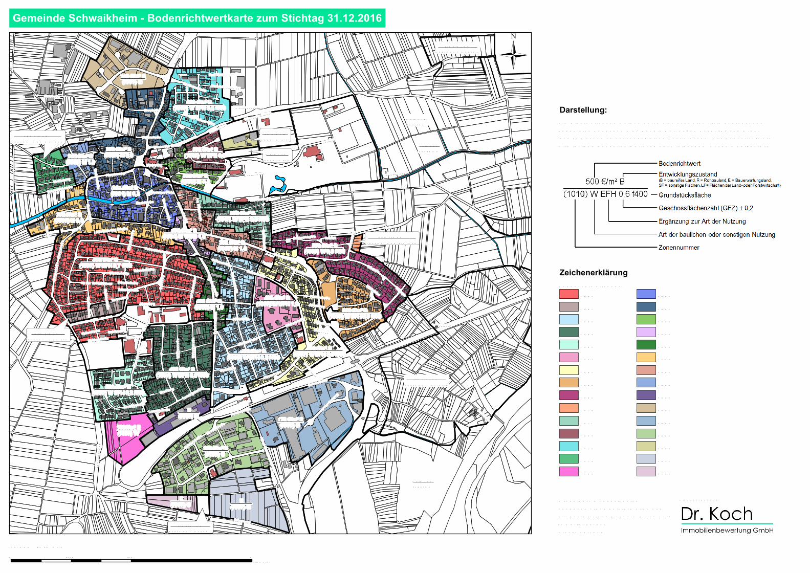
Die Ric htwe rtzone n we rd e n d urc h e ine sc hwarze Linie b e gre nzt und hab e n e ine Z one nnum m e r. Für d ie N utzunge n Ac ke r (A) und Grün-land (GR) kann e s d e c kungsgle ic he Z one n ge b e n. De r Bod e nric htwe rt wird für je d e Bod e nric htwe rtzone nach folge nd e m Sc he m a d arge ste llt:
Darstellung:
ZeichenerklärungBod e nric htwe rtzone n:
200120022003200420052006200720082051300130023003300430513052
100110021003100410051006100710081009101010111012101310141055