Embed Size (px)
Citation preview

Manual on Mangrove reversion of abandoned and illegal brackishwater fishpondsMangrove Manual SerieS no. 2
JH Primavera, WG Yap, JP Savaris, RJA Loma, ADE Moscoso,JD Coching, CL Montilijao, RP Poingan, ID Tayo
First edition 2014
This publication has been made possible thanks primarily to the generous funding from the Deutsche Gesellschaft für Internationale Zusammenarbeit (GIZ) GmbH.
The views expressed in this publication are those of the authors and do not necessarily reflect those of the Zoological Society of London or any of the funding organisations.
Published by: Zoological Society of London – CMRP Philippines, Inc.
Copyright: ©2013 Zoological Society of London
Reproduction of this publication for educational or other non-commercial purposes is authorised without prior written permission from the copyright holder provided the source is fully acknowledged. Reproduction of this publication for resale or other commercial purposes is strictly prohibited without prior written permission of the copyright holder.
Citation: JH Primavera, WG Yap, JP Savaris, RJA Loma, ADE Moscoso, JD Coching, CL Montilijao, RP Poingan, ID Tayo (2013). Manual on Mangrove Reversion of Abandoned and Illegal Brackishwater Fishponds – Mangrove Manual Series No. 2. London, UK: ZSL. xii + 108 p.
ISBN: ISBN 978-971-95370-2-1
Front cover: Avicennia marina seedlings in early regenerating abandoned pond in Dumangas, Iloilo (photo by Jofel Coching/ZSL)
Back cover: Mature stands of Sonneratia alba and Avicennia marina line the dike separating former ponds in Sinandigan, Ubay, Bohol (photo by Jofel Coching/ZSL)
Layout and design by: Makinaugalingon Printer and Bookbinder, Philippines
Produced by: The Zoological Society of London
Printed by: Makinaugalingon Printer and Bookbinder, Philippines
Available from: ZSL-Philippines 48 Burgos St., La Paz, Iloilo City, Philippines
Download document at: ZSL: http://www.zsl.org/mangroves/manual GIZ: http://acccoast.pawb.gov.ph/

On behalf of the Deutsche Gesellschaft für Internationale Zusammenarbeit (GIZ) GmbH, the German Agency for International Cooperation, I am honored to take this opportunity to thank the authors and all others involved in making this long awaited manual a reality.
Coastal ecosystems and especially mangrove forests have become severely impaired by human activity, and yet they encompass crucial habitats which buffer the effects of climate change to coastal communities and ecosystems and serve as a source for long term food security. Mangrove rehabilitation, as one recognized approach to increase resilience of these habitats, has come increasingly into focus in the German government’s development work.
GIZ, together with the Coastal and Marine Management Office (CMMO) of the DENR-PAWB, directs assistance to rehabilitating coastal ecosystems and their technical and institutional governance through its project Adaptation to Climate Change in Coastal Areas (ACCCoast). This is to support the Filipino people and their national targets in the aforementioned context which in a wider scope serve as the Philippine contribution to the regional Coral Triangle Initiative.
In line with this, GIZ also puts a special emphasis in fostering research to gain baseline data and best practices as a basis to integrate different mandates for jointly managing coastal resources. This can only be done successfully when tenurial status and boundary determinations are clear and documented. With the devastating impact of the typhoon Yolanda on many communities in the Visayas in November 2013, it is therefore high time to achieve the final goal of putting in place the right policies and scientific guidelines for mangrove conservation and rehabilitation.
With the underlying “Manual for Pond Reversion,” GIZ will therefore continue to support the implementation of reversion of abandoned, underutilised and undeveloped (AUU) fishponds to mangrove forest and collaborate with capable partners like the Zoological Society of London (ZSL).
In essence, I may say that sustainable management of coastal resources is not only part of a mere policy but our contribution to providing a secure and resilient environment for future generations.
Patrick Schwab
Chief Advisor, “Adaptation to Climate Change in Coastal Areas” Project Deutsche Gesellschaft für Internationale Zusammenarbeit (GIZ) GmbH
foreword
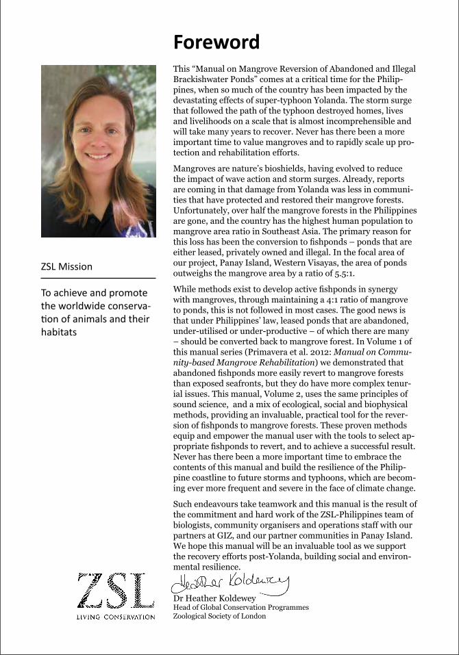
This “Manual on Mangrove Reversion of Abandoned and Illegal Brackishwater Ponds” comes at a critical time for the Philip-pines, when so much of the country has been impacted by the devastating effects of super-typhoon Yolanda. The storm surge that followed the path of the typhoon destroyed homes, lives and livelihoods on a scale that is almost incomprehensible and will take many years to recover. Never has there been a more important time to value mangroves and to rapidly scale up pro-tection and rehabilitation efforts.
Mangroves are nature’s bioshields, having evolved to reduce the impact of wave action and storm surges. Already, reports are coming in that damage from Yolanda was less in communi-ties that have protected and restored their mangrove forests. Unfortunately, over half the mangrove forests in the Philippines are gone, and the country has the highest human population to mangrove area ratio in Southeast Asia. The primary reason for this loss has been the conversion to fishponds – ponds that are either leased, privately owned and illegal. In the focal area of our project, Panay Island, Western Visayas, the area of ponds outweighs the mangrove area by a ratio of 5.5:1.
While methods exist to develop active fishponds in synergy with mangroves, through maintaining a 4:1 ratio of mangrove to ponds, this is not followed in most cases. The good news is that under Philippines’ law, leased ponds that are abandoned, under-utilised or under-productive – of which there are many – should be converted back to mangrove forest. In Volume 1 of this manual series (Primavera et al. 2012: Manual on Commu-nity-based Mangrove Rehabilitation) we demonstrated that abandoned fishponds more easily revert to mangrove forests than exposed seafronts, but they do have more complex tenur-ial issues. This manual, Volume 2, uses the same principles of sound science, and a mix of ecological, social and biophysical methods, providing an invaluable, practical tool for the rever-sion of fishponds to mangrove forests. These proven methods equip and empower the manual user with the tools to select ap-propriate fishponds to revert, and to achieve a successful result. Never has there been a more important time to embrace the contents of this manual and build the resilience of the Philip-pine coastline to future storms and typhoons, which are becom-ing ever more frequent and severe in the face of climate change.
Such endeavours take teamwork and this manual is the result of the commitment and hard work of the ZSL-Philippines team of biologists, community organisers and operations staff with our partners at GIZ, and our partner communities in Panay Island. We hope this manual will be an invaluable tool as we support the recovery efforts post-Yolanda, building social and environ-mental resilience.
Dr Heather KoldeweyHead of Global Conservation ProgrammesZoological Society of London
ZSL Mission
To achieve and promote the worldwide conserva-tion of animals and their habitats
foreword
contents
Foreword . . . . . . . . . . . . . . . . . . . . . . . . . . . . . . . . . . . . . . . . . . . . . . . . . . . . . . . . . . iii
Acknowledgements . . . . . . . . . . . . . . . . . . . . . . . . . . . . . . . . . . . . . . . . . . . . . . . . . vii
List of Tables, Figures, Boxes and Appendices . . . . . . . . . . . . . . . . . . . . . . . . . . ix
Acronyms and Abbreviations . . . . . . . . . . . . . . . . . . . . . . . . . . . . . . . . . . . . . . . . . xii
Introduction . . . . . . . . . . . . . . . . . . . . . . . . . . . . . . . . . . . . . . . . . . . . . . . . . . . . . . . 1
A. Mangrove Zonation and Species Selection . . . . . . . . . . . . . . . . . . . . . . . . 2
B. Mangrove Status . . . . . . . . . . . . . . . . . . . . . . . . . . . . . . . . . . . . . . . . . . . . . 4
C. Seafront vs Middle to Upper Intertidal Zones . . . . . . . . . . . . . . . . . . . . . 6
D. The Brackishwater Pond Aquaculture System . . . . . . . . . . . . . . . . . . . . . 7
E. The FLA System and Other Tenurial Instruments . . . . . . . . . . . . . . . . . . 10
F. FLA Cancellation and Pond Reversion (Abandoned, Undeveloped and Underutilized Fishponds) . . . . . . . . . . . 16
G. Mangrove-Friendly Aquaculture . . . . . . . . . . . . . . . . . . . . . . . . . . . . . . . . 20
Inventory of Brackishwater Ponds . . . . . . . . . . . . . . . . . . . . . . . . . . . . . . . . . . . . . 22
A. Preliminary Steps . . . . . . . . . . . . . . . . . . . . . . . . . . . . . . . . . . . . . . . . . . . . . 22
B. Zero to Minimum Contact Approach . . . . . . . . . . . . . . . . . . . . . . . . . . . . . 22
C. Data Required and Sources . . . . . . . . . . . . . . . . . . . . . . . . . . . . . . . . . . . . . 23
D. Rapid Method of Determining Extent of Illegal Fishponds . . . . . . . . . . 29
E. Mapping Fishponds by Tenure . . . . . . . . . . . . . . . . . . . . . . . . . . . . . . . . . . 29
F. Expected Problems . . . . . . . . . . . . . . . . . . . . . . . . . . . . . . . . . . . . . . . . . . . . 31
G. Human Resource Requirements . . . . . . . . . . . . . . . . . . . . . . . . . . . . . . . . . 33
Biophysical Considerations . . . . . . . . . . . . . . . . . . . . . . . . . . . . . . . . . . . . . . . . . . . 35
A. Tidal Elevation and Hydrology . . . . . . . . . . . . . . . . . . . . . . . . . . . . . . . . . . 35
B. Mangrove Species and Environmental Factors . . . . . . . . . . . . . . . . . . . . . 38
C. Assisted Natural Regeneration (Planting), Wildings and Nurseries . . . 40
D. Problems . . . . . . . . . . . . . . . . . . . . . . . . . . . . . . . . . . . . . . . . . . . . . . . . . . . . 44
Protocols for Pond Reversion . . . . . . . . . . . . . . . . . . . . . . . . . . . . . . . . . . . . . . . . . 48
A. Site Selection . . . . . . . . . . . . . . . . . . . . . . . . . . . . . . . . . . . . . . . . . . . . . . . . 48
B. Planting Materials . . . . . . . . . . . . . . . . . . . . . . . . . . . . . . . . . . . . . . . . . . . . 49
C. Planting Strategy . . . . . . . . . . . . . . . . . . . . . . . . . . . . . . . . . . . . . . . . . . . . . 53
D. Outplanting . . . . . . . . . . . . . . . . . . . . . . . . . . . . . . . . . . . . . . . . . . . . . . . . . 54
E. Problems, Protection and Maintenance . . . . . . . . . . . . . . . . . . . . . . . . . . . 56
F. Monitoring . . . . . . . . . . . . . . . . . . . . . . . . . . . . . . . . . . . . . . . . . . . . . . . . . . . 58
References . . . . . . . . . . . . . . . . . . . . . . . . . . . . . . . . . . . . . . . . . . . . . . . . . . . . . . . . . 63
Glossary . . . . . . . . . . . . . . . . . . . . . . . . . . . . . . . . . . . . . . . . . . . . . . . . . . . . . . . . . . . 67
Appendices . . . . . . . . . . . . . . . . . . . . . . . . . . . . . . . . . . . . . . . . . . . . . . . . . . . . . . . . 71

acknowledgements
The project “Identifying brackishwater fishponds, and establishing biophysical protocols, for mangrove reversion in Panay Island: A climate change mitigation strategy” of the Zoological Society of London – Philippines, and this subsequent publication, have been made possible by generous funding from the Deutsche Ge-sellschaft für Internationale Zusammenarbeit (GIZ). Additional funding from the Zoological Society of London and project partners was invaluable in achieving the great successes of the project.
We would like to give particular thanks to the following individuals and organisa-tions for their enthusiasm and commitment to mangrove conservation. Without them, the success of this Project and this publication would not have been possible.
Community groups
Barangay Pedada Fisherfolk Association Bugtongbato Fisherfolk AssociationKatilingban Sang Magagmay nga Mangingisda sa DoloresNew Balaring Mangrove Association
Government bodies
Ibajay, Aklan Local Government UnitAjuy, Iloilo Local Government Unit Dumangas, Iloilo Local Government UnitLeganes, Iloilo Local Government UnitZarraga, Iloilo Local Government UnitOton, Iloilo Local Government UnitIvisan, Capiz Local Government UnitPanay, Capiz Local Government UnitNueva Valencia, Guimaras Local Government UnitAklan Provincial Local Government UnitCapiz Provincial Local Government UnitGuimaras Provincial Local Government UnitIloilo Provincial Local Government UnitBureau of Fisheries and Aquatic Resources, Region 6Bureau of Fisheries and Aquatic Resources, Central OfficeDepartment of Environment and Natural Resources, Region 6Land Management Service, DENR Region 6Land Management Bureau, DENR Land Registration AuthorityDENR Community Environment and Natural Resources, SaraDENR Community Environment and Natural Resources, Barotac NuevoDENR Provincial Environment and Natural Resources, CapizDENR Provincial Environment and Natural Resources, Iloilo
Academia and research bodies
Aquaculture Department, Southeast Asian Fisheries Development CenterUniversity of the Philippines VisayasNorthern Iloilo Polytechnic State College – Ajuy Campus
Fishpond operators/ caretakers
Juancito JastillanoAdolfo JaenManuel VillaretDandilong CervandoIsmael CervandoEmmanuel PrudenteJohn BascoRosario SasisSarwin PeruchoPaquito SacapanoCarlito Portillo Jr.Julio BelmonteBenjamin AnasJuanito Jandan Sr.Ernanie Batisla-ongPaderno Dema-alaSerio BiatingJerry QuilloFlorencio DerlaNorberto Abugada
NGOs
Conservation InternationalNGOs for Fisheries ReformProject Seahorse Foundation for Marine ConservationTanggol Kalikasan
Individuals
Merlina AndalecioMerle AntohadoEnriquita BarrogoAllan BatabatJose Marie BrillantesBenjamin BrownElisa del Carmen-BrundaAlice Joan FerrerSwelo Gojo Sr.Enicito LagunaBonifacio SapioRobilo Sta. LuciaLolito Umiten
Images are provided by the ZSL-Philippines, unless credited otherwise.
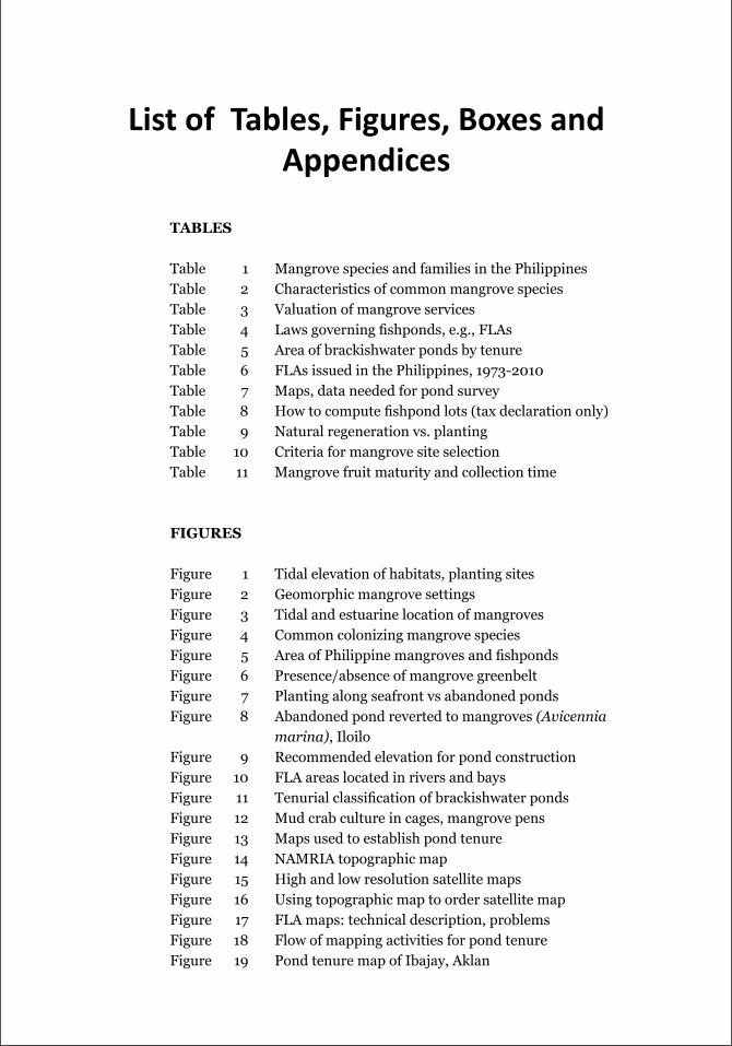
TAbles
Table 1 Mangrove species and families in the PhilippinesTable 2 Characteristics of common mangrove speciesTable 3 Valuation of mangrove services Table 4 Laws governing fishponds, e.g., FLAsTable 5 Area of brackishwater ponds by tenureTable 6 FLAs issued in the Philippines, 1973-2010Table 7 Maps, data needed for pond surveyTable 8 How to compute fishpond lots (tax declaration only)Table 9 Natural regeneration vs. plantingTable 10 Criteria for mangrove site selectionTable 11 Mangrove fruit maturity and collection time
FIGures
Figure 1 Tidal elevation of habitats, planting sitesFigure 2 Geomorphic mangrove settingsFigure 3 Tidal and estuarine location of mangrovesFigure 4 Common colonizing mangrove speciesFigure 5 Area of Philippine mangroves and fishpondsFigure 6 Presence/absence of mangrove greenbeltFigure 7 Planting along seafront vs abandoned pondsFigure 8 Abandoned pond reverted to mangroves (Avicennia
marina), IloiloFigure 9 Recommended elevation for pond constructionFigure 10 FLA areas located in rivers and bays Figure 11 Tenurial classification of brackishwater pondsFigure 12 Mud crab culture in cages, mangrove pensFigure 13 Maps used to establish pond tenureFigure 14 NAMRIA topographic mapFigure 15 High and low resolution satellite mapsFigure 16 Using topographic map to order satellite mapFigure 17 FLA maps: technical description, problemsFigure 18 Flow of mapping activities for pond tenureFigure 19 Pond tenure map of Ibajay, Aklan
list of tables, figures, boxes and appendices
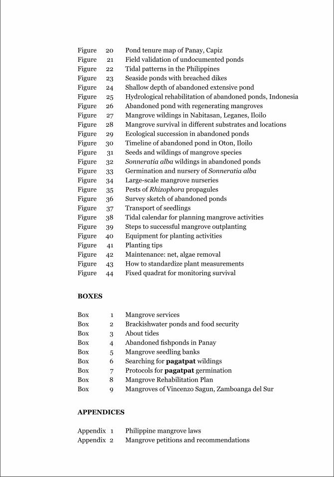
Figure 20 Pond tenure map of Panay, CapizFigure 21 Field validation of undocumented pondsFigure 22 Tidal patterns in the PhilippinesFigure 23 Seaside ponds with breached dikesFigure 24 Shallow depth of abandoned extensive pondFigure 25 Hydrological rehabilitation of abandoned ponds, IndonesiaFigure 26 Abandoned pond with regenerating mangrovesFigure 27 Mangrove wildings in Nabitasan, Leganes, IloiloFigure 28 Mangrove survival in different substrates and locationsFigure 29 Ecological succession in abandoned pondsFigure 30 Timeline of abandoned pond in Oton, IloiloFigure 31 Seeds and wildings of mangrove speciesFigure 32 Sonneratia alba wildings in abandoned pondsFigure 33 Germination and nursery of Sonneratia albaFigure 34 Large-scale mangrove nurseriesFigure 35 Pests of Rhizophora propagulesFigure 36 Survey sketch of abandoned pondsFigure 37 Transport of seedlingsFigure 38 Tidal calendar for planning mangrove activitiesFigure 39 Steps to successful mangrove outplantingFigure 40 Equipment for planting activitiesFigure 41 Planting tipsFigure 42 Maintenance: net, algae removalFigure 43 How to standardize plant measurementsFigure 44 Fixed quadrat for monitoring survival
bOxes
Box 1 Mangrove servicesBox 2 Brackishwater ponds and food securityBox 3 About tidesBox 4 Abandoned fishponds in PanayBox 5 Mangrove seedling banksBox 6 Searching for pagatpat wildingsBox 7 Protocols for pagatpat germinationBox 8 Mangrove Rehabilitation PlanBox 9 Mangroves of Vincenzo Sagun, Zamboanga del Sur
AppeNdICes
Appendix 1 Philippine mangrove lawsAppendix 2 Mangrove petitions and recommendations
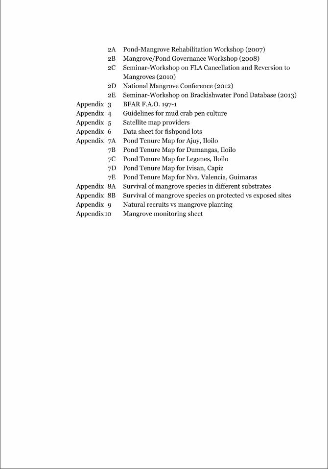
2A Pond-Mangrove Rehabilitation Workshop (2007) 2B Mangrove/Pond Governance Workshop (2008) 2C Seminar-Workshop on FLA Cancellation and Reversion to
Mangroves (2010) 2D National Mangrove Conference (2012) 2E Seminar-Workshop on Brackishwater Pond Database (2013)Appendix 3 BFAR F.A.O. 197-1Appendix 4 Guidelines for mud crab pen cultureAppendix 5 Satellite map providersAppendix 6 Data sheet for fishpond lotsAppendix 7A Pond Tenure Map for Ajuy, Iloilo 7B Pond Tenure Map for Dumangas, Iloilo 7C Pond Tenure Map for Leganes, Iloilo 7D Pond Tenure Map for Ivisan, Capiz 7E Pond Tenure Map for Nva. Valencia, GuimarasAppendix 8A Survival of mangrove species in different substratesAppendix 8B Survival of mangrove species on protected vs exposed sitesAppendix 9 Natural recruits vs mangrove plantingAppendix 10 Mangrove monitoring sheet
ACCCoastANRASC
ASEANAUU
BLLMCARL
CENROCMRP
CRMGISGIZ
DA-BFARDENR
DBPDILGDOFFLA
FRQDGISGPSLGULMS
MAOMCSMFAMSLMSO
NAMRIANCRNFRNGO
NRPENRO
POPTFCF
RFCSBA
SEAFDECSUCsTROZSL
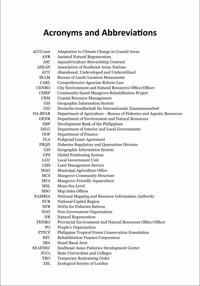
acronyms and abbreviations
Adaptation to Climate Change in Coastal AreasAssisted Natural RegenerationAquasilviculture Stewardship ContractAssociation of Southeast Asian NationsAbandoned, Undeveloped and UnderutilizedBureau of Lands Location MonumentsComprehensive Agrarian Reform LawCity Environment and Natural Resources Office/OfficerCommunity-based Mangrove Rehabilitation ProjectCoastal Resource ManagementGeographic Information SystemDeutsche Gesellschaft für Internationale ZusammenarbeitDepartment of Agriculture – Bureau of Fisheries and Aquatic ResourcesDepartment of Environment and Natural ResourcesDevelopment Bank of the PhilippinesDepartment of Interior and Local GovernmentsDepartment of FinanceFishpond Lease AgreementFisheries Regulatory and Quarantine DivisionGeographic Information SystemGlobal Positioning SystemLocal Government UnitLand Management ServiceMunicipal Agriculture OfficeMangrove Community StructureMangrove-Friendly AquacultureMean Sea LevelMap Sales OfficesNational Mapping and Resource Information AuthorityNational Capital RegionNGOs for Fisheries ReformNon-Government OrganizationNatural RegenerationProvincial Environment and Natural Resources Office/OfficerPeople’s OrganizationPhilippine Tropical Forest Conservation FoundationRehabilitation Finance CorporationStand Basal AreaSoutheast Asian Fisheries Development CenterState Universities and CollegesTemporary Restraining OrderZoological Society of London

ManuaL on Mangrove reverSion of abandoned and iLLegaL brackiShwaTer fiShpondS 1
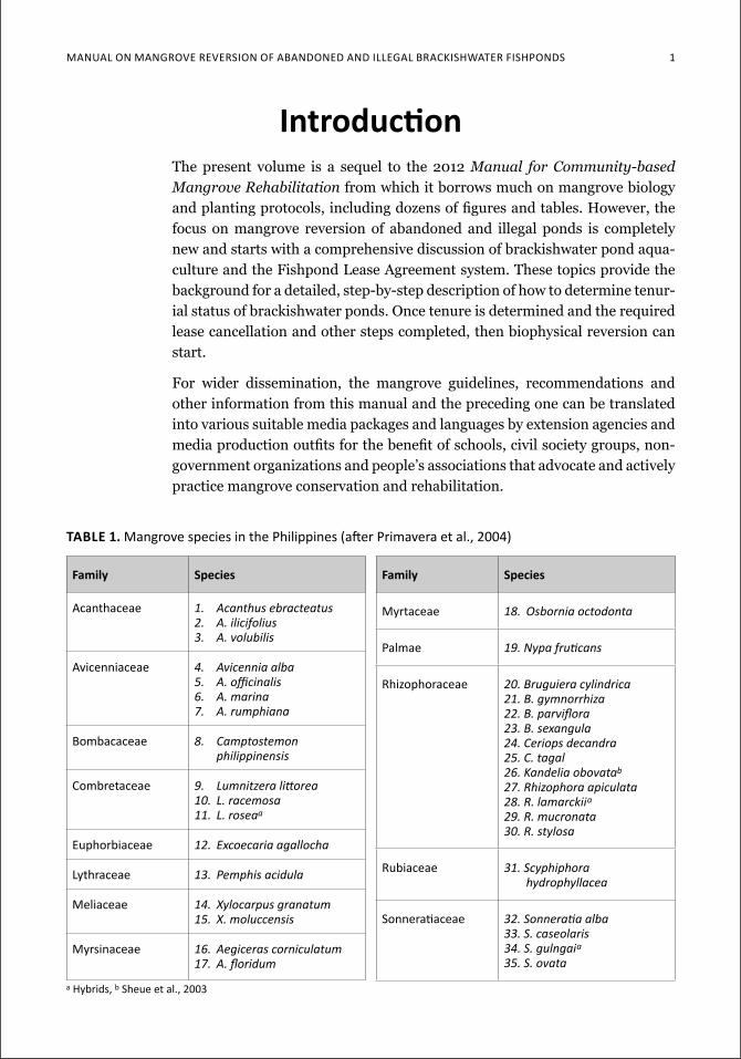
introductionThe present volume is a sequel to the 2012 Manual for Community-based Mangrove Rehabilitation from which it borrows much on mangrove biology and planting protocols, including dozens of figures and tables. However, the focus on mangrove reversion of abandoned and illegal ponds is completely new and starts with a comprehensive discussion of brackishwater pond aqua-culture and the Fishpond Lease Agreement system. These topics provide the background for a detailed, step-by-step description of how to determine tenur-ial status of brackishwater ponds. Once tenure is determined and the required lease cancellation and other steps completed, then biophysical reversion can start.
For wider dissemination, the mangrove guidelines, recommendations and other information from this manual and the preceding one can be translated into various suitable media packages and languages by extension agencies and media production outfits for the benefit of schools, civil society groups, non-government organizations and people’s associations that advocate and actively practice mangrove conservation and rehabilitation.
family species
acanthaceae 1. Acanthus ebracteatus2. A. ilicifolius3. A. volubilis
avicenniaceae 4. Avicennia alba5. A.officinalis6. A. marina7. A. rumphiana
bombacaceae 8. Camptostemon philippinensis
combretaceae 9. Lumnitzeralittorea10. L. racemosa11. L. roseaa
euphorbiaceae 12. Excoecaria agallocha
Lythraceae 13. Pemphis acidula
Meliaceae 14. Xylocarpus granatum15. X. moluccensis
Myrsinaceae 16. Aegiceras corniculatum17. A.floridum
family species
Myrtaceae 18. Osbornia octodonta
palmae 19.Nypafruticans
rhizophoraceae 20. Bruguiera cylindrica21. B. gymnorrhiza22.B.parviflora23. B. sexangula24. Ceriops decandra25. C. tagal26. Kandelia obovatab
27. Rhizophora apiculata28. R. lamarckiia
29. R. mucronata30. R. stylosa
rubiaceae 31. Scyphiphora hydrophyllacea
Sonneratiaceae 32.Sonneratiaalba33. S. caseolaris34. S. gulngaia
35. S. ovata
table 1. Mangrove species in the Philippines (after Primavera et al., 2004)
a Hybrids, b Sheue et al., 2003
2 Mangrove Manual SerieS no. 2
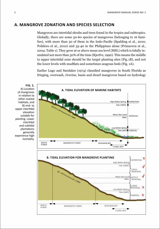
fig. 1. a) location
of mangroves in relation to other coastal habitats, and
B) mid- to upper intertidal
elevation suitable for
planting. lower intertidal
and subtidal plantations
generally experience high
mortality.
b. tidal elevation for Mangrove planting
a. tidal elevation of Marine habitats
a. Mangrove Zonation and species selection
Mangroves are intertidal shrubs and trees found in the tropics and subtropics. Globally, there are some 50-60 species of mangroves (belonging to 16 fami-lies), with more than 50 of them in the Indo-Pacific (Spalding et al., 2010; Polidoro et al., 2010) and 35-40 in the Philippines alone (Primavera et al., 2004: Table 1). They grow at or above mean sea level (MSL) which is tidally in-undated not more than 30% of the time (Kjerfve, 1990). This means the middle to upper intertidal zone should be the target planting sites (Fig. 1B), and not the lower levels with mudflats and sometimes seagrass beds (Fig. 1A).
Earlier Lugo and Snedaker (1974) classified mangroves in South Florida as fringing, overwash, riverine, basin and dwarf mangroves based on hydrology
Manual on Mangrove reverSion of aBandoned and illegal BrackiSHwater fiSHPondS 3
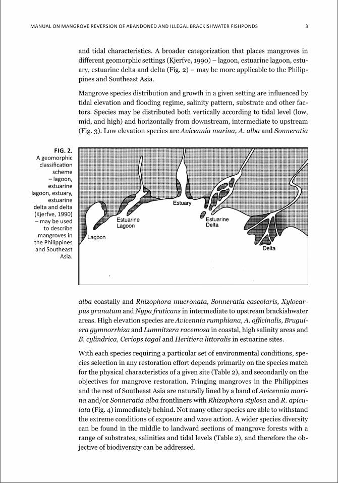
and tidal characteristics. A broader categorization that places mangroves in different geomorphic settings (Kjerfve, 1990) – lagoon, estuarine lagoon, estu-ary, estuarine delta and delta (Fig. 2) – may be more applicable to the Philip-pines and Southeast Asia.
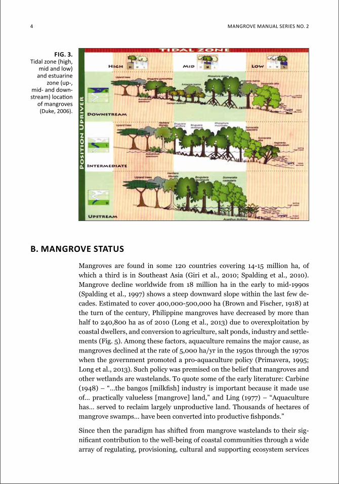
Mangrove species distribution and growth in a given setting are influenced by tidal elevation and flooding regime, salinity pattern, substrate and other fac-tors. Species may be distributed both vertically according to tidal level (low, mid, and high) and horizontally from downstream, intermediate to upstream (Fig. 3). Low elevation species are Avicennia marina, A. alba and Sonneratia
Fig. 2. a geomorphic
classification scheme
– lagoon, estuarine
lagoon, estuary, estuarine
delta and delta (kjerfve, 1990) – may be used
to describe mangroves in
the philippines and Southeast
asia.
alba coastally and Rhizophora mucronata, Sonneratia caseolaris, Xylocar-pus granatum and Nypa fruticans in intermediate to upstream brackishwater areas. High elevation species are Avicennia rumphiana, A. officinalis, Brugui-era gymnorrhiza and Lumnitzera racemosa in coastal, high salinity areas and B. cylindrica, Ceriops tagal and Heritiera littoralis in estuarine sites.
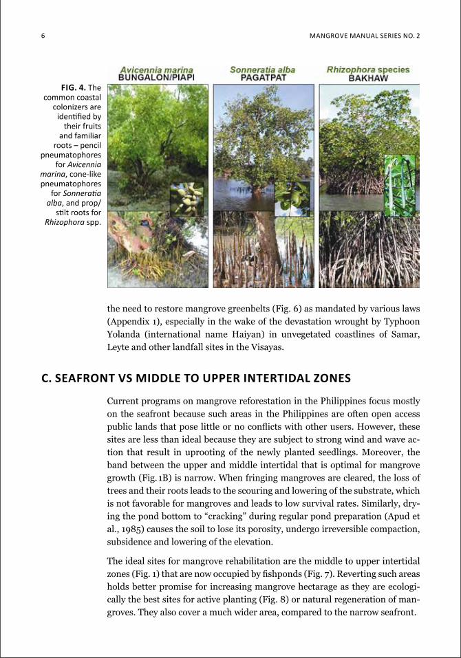
With each species requiring a particular set of environmental conditions, spe-cies selection in any restoration effort depends primarily on the species match for the physical characteristics of a given site (Table 2), and secondarily on the objectives for mangrove restoration. Fringing mangroves in the Philippines and the rest of Southeast Asia are naturally lined by a band of Avicennia mari-na and/or Sonneratia alba frontliners with Rhizophora stylosa and R. apicu-lata (Fig. 4) immediately behind. Not many other species are able to withstand the extreme conditions of exposure and wave action. A wider species diversity can be found in the middle to landward sections of mangrove forests with a range of substrates, salinities and tidal levels (Table 2), and therefore the ob-jective of biodiversity can be addressed.
4 Mangrove Manual SerieS no. 2
fig. 3. tidal zone (high,
mid and low) and estuarine
zone (up-, mid- and down-stream) location
of mangroves (duke, 2006).
b. Mangrove status
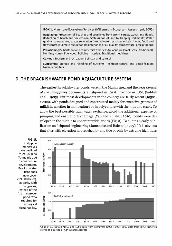
Mangroves are found in some 120 countries covering 14-15 million ha, of which a third is in Southeast Asia (Giri et al., 2010; Spalding et al., 2010). Mangrove decline worldwide from 18 million ha in the early to mid-1990s (Spalding et al., 1997) shows a steep downward slope within the last few de-cades. Estimated to cover 400,000-500,000 ha (Brown and Fischer, 1918) at the turn of the century, Philippine mangroves have decreased by more than half to 240,800 ha as of 2010 (Long et al., 2013) due to overexploitation by coastal dwellers, and conversion to agriculture, salt ponds, industry and settle-ments (Fig. 5). Among these factors, aquaculture remains the major cause, as mangroves declined at the rate of 5,000 ha/yr in the 1950s through the 1970s when the government promoted a pro-aquaculture policy (Primavera, 1995; Long et al., 2013). Such policy was premised on the belief that mangroves and other wetlands are wastelands. To quote some of the early literature: Carbine (1948) – “…the bangos [milkfish] industry is important because it made use of… practically valueless [mangrove] land,” and Ling (1977) – “Aquaculture has… served to reclaim largely unproductive land. Thousands of hectares of mangrove swamps… have been converted into productive fishponds.”
Since then the paradigm has shifted from mangrove wastelands to their sig-nificant contribution to the well-being of coastal communities through a wide array of regulating, provisioning, cultural and supporting ecosystem services
ManuaL on Mangrove reverSion of abandoned and iLLegaL brackiShwaTer fiShpondS 5
(Box 1: Millennium Ecosystem Assessment, 2005). These goods and services include coastal protection from typhoons and storm surges, erosion control, flood regulation, nutrient supply/recycling, fisheries maintenance, and for-estry products. The total value of such goods and services ranges from around US$14,000/ha to $16,000/ha with the biggest contribution from coastal pro-tection (Table 3).
To minimize the impacts of pond construction on mangrove ecosystems and their associated fisheries, Saenger et al. (1983) recommended that “… the amount of mangrove forest converted into ponds should not exceed one ha of ponds for 4 ha of natural mangrove kept untouched.” This means that no more than 20% of a discrete mangrove area should be converted to ponds. The pres-ent 240,800 of remaining mangroves and 239,000 ha of fish/shrimp culture ponds in the Philippines give a 1:1 pond-to-mangrove ratio, which is way below the ideal 4:1 ratio. Therefore there is an urgent need to increase mangrove area in the country by rehabilitating degraded sites, i.e., abandoned ponds and for-mer fringing mangroves, while protecting remaining forests. Equally urgent is
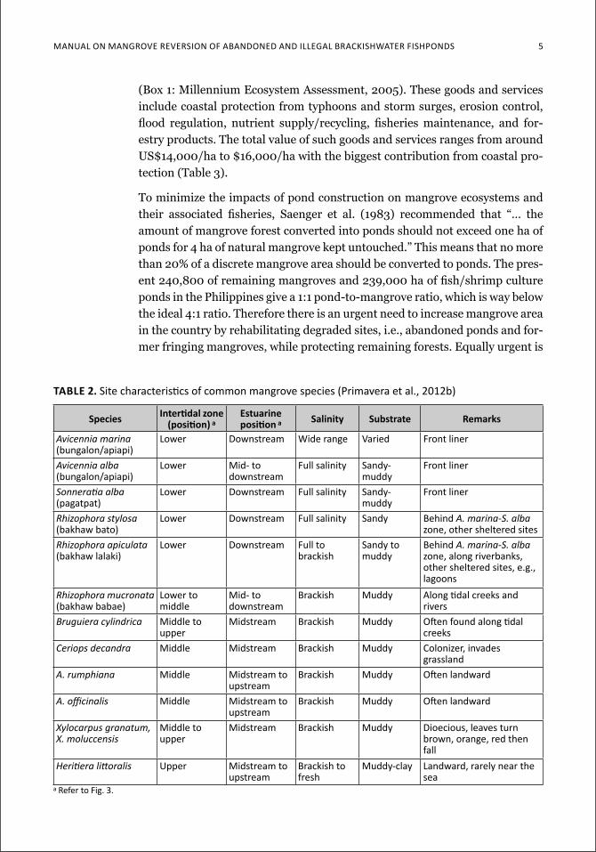
Table 2. Site characteristics of common mangrove species (Primavera et al., 2012b)
species intertidal zone (position) a
estuarine position a salinity substrate remarks
Avicennia marina (bungalon/apiapi)
Lower downstream wide range varied front liner
Avicennia alba (bungalon/apiapi)
Lower Mid- to downstream
full salinity Sandy-muddy
front liner
Sonneratiaalba(pagatpat)
Lower downstream full salinity Sandy-muddy
front liner
Rhizophora stylosa (bakhaw bato)
Lower downstream full salinity Sandy behind A. marina-S. alba zone, other sheltered sites
Rhizophora apiculata (bakhaw lalaki)
Lower downstream full to brackish
Sandy to muddy
behind A. marina-S. alba zone, along riverbanks, other sheltered sites, e.g., lagoons
Rhizophora mucronata (bakhaw babae)
Lower to middle
Mid- to downstream
brackish Muddy along tidal creeks and rivers
Bruguiera cylindrica Middle to upper
Midstream brackish Muddy often found along tidal creeks
Ceriops decandra Middle Midstream brackish Muddy colonizer, invades grassland
A. rumphiana Middle Midstream to upstream
brackish Muddy often landward
A.officinalis Middle Midstream to upstream
brackish Muddy often landward
Xylocarpus granatum, X. moluccensis
Middle to upper
Midstream brackish Muddy dioecious, leaves turn brown, orange, red then fall
Heritieralittoralis upper Midstream to upstream
brackish to fresh
Muddy-clay landward, rarely near the sea
a refer to fig. 3.
6 Mangrove Manual SerieS no. 2
the need to restore mangrove greenbelts (Fig. 6) as mandated by various laws (Appendix 1), especially in the wake of the devastation wrought by Typhoon Yolanda (international name Haiyan) in unvegetated coastlines of Samar, Leyte and other landfall sites in the Visayas.
c. seafront vs Middle to upper intertidal Zones
Current programs on mangrove reforestation in the Philippines focus mostly on the seafront because such areas in the Philippines are often open access public lands that pose little or no conflicts with other users. However, these sites are less than ideal because they are subject to strong wind and wave ac-tion that result in uprooting of the newly planted seedlings. Moreover, the band between the upper and middle intertidal that is optimal for mangrove growth (Fig. 1B) is narrow. When fringing mangroves are cleared, the loss of trees and their roots leads to the scouring and lowering of the substrate, which is not favorable for mangroves and leads to low survival rates. Similarly, dry-ing the pond bottom to “cracking” during regular pond preparation (Apud et al., 1985) causes the soil to lose its porosity, undergo irreversible compaction, subsidence and lowering of the elevation.
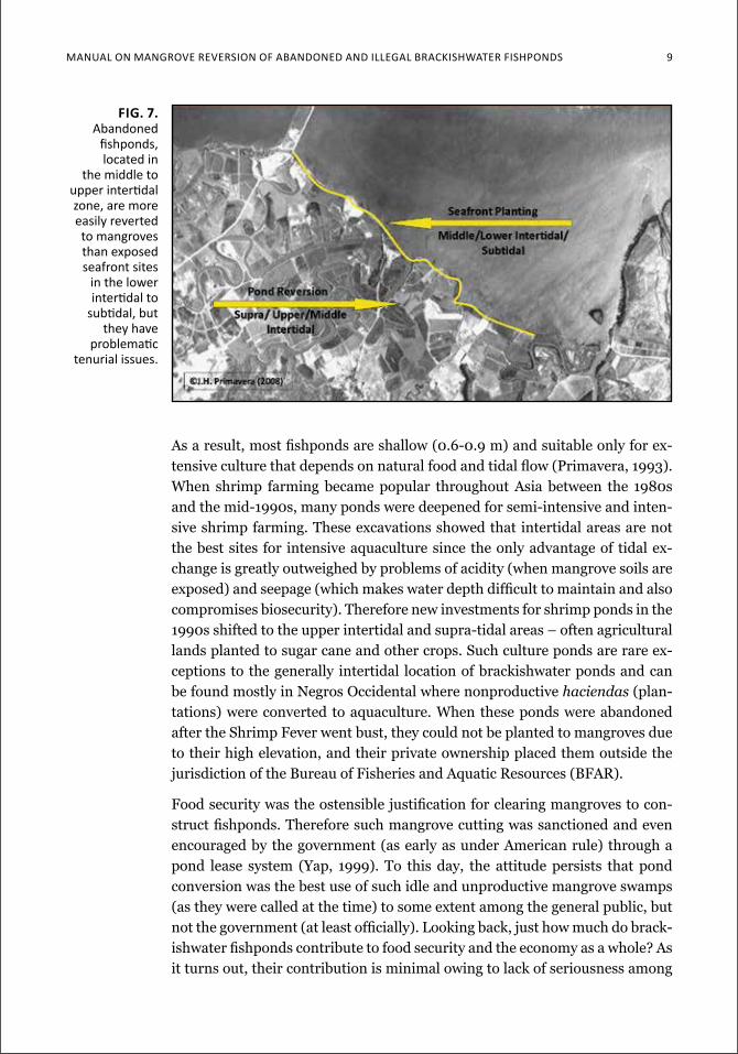
The ideal sites for mangrove rehabilitation are the middle to upper intertidal zones (Fig. 1) that are now occupied by fishponds (Fig. 7). Reverting such areas holds better promise for increasing mangrove hectarage as they are ecologi-cally the best sites for active planting (Fig. 8) or natural regeneration of man-groves. They also cover a much wider area, compared to the narrow seafront.
fig. 4. The common coastal
colonizers are identified by
their fruits and familiar
roots – pencil pneumatophores
for Avicennia marina, cone-like pneumatophores
for Sonneratiaalba, and prop/
stilt roots for Rhizophora spp.
ManuaL on Mangrove reverSion of abandoned and iLLegaL brackiShwaTer fiShpondS 7
d. the brackishwater pond aquaculture systeM
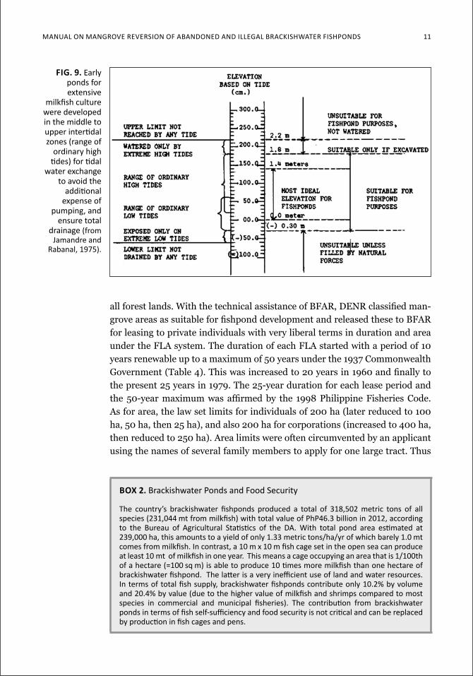
The earliest brackishwater ponds were in the Manila area and the 1921 Census of the Philippines documents a fishpond in Rizal Province in 1863 (Siddall et al., 1985). But most developments in the country are fairly recent (1950s-1970s), with ponds designed and constructed mainly for extensive growout of milkfish, whether in monoculture or in polyculture with shrimps and crabs. To allow the best possible tidal water exchange, avoid the additional expense of pumping and ensure total drainage (Yap and Villaluz, 2010), ponds were de-veloped in the middle to upper intertidal zones (Fig. 9). To quote an early pub-lication on fishpond engineering (Jamandre and Rabanal, 1975): “It is obvious that sites with elevation not reached by any tide or only by extreme high tides
fig. 5. philippine
mangroves have declined to 240,800 ha
(a) mainly due to aquaculture development. brackishwater
fishponds now cover
239,000 ha (B), at parity with
mangroves, instead of the
4:1 mangrove-pond ratio
required for ecological
sustainability.
box 1. Mangrove ecosystem Services (Millennium ecosystem assessment, 2005)regulating: Protection of beaches and coastlines from storm surges, waves and floods, reduction of beach and soil erosion; Stabilization of land by trapping sediments; water quality maintenance; water regulation (groundwater recharge and discharge, flood and flow control); climate regulation (maintenance of air quality, temperature, precipitation);
Provisioning: Subsistence and commercial fisheries; aquaculture (small-scale, traditional); Hunting; Honey; fuelwood; Building materials; traditional medicines
Cultural: tourism and recreation; Spiritual and cultural
Supporting: Storage and recycling of nutrients; Pollution control and detoxification; nursery habitats
along et al. (2013); b1950 and 1960 data from Primavera (1995); 1964-2010 data from Bfar fisheries Profile and Bureau of agricultural Statistics
8 Mangrove Manual SerieS no. 2
are not very suitable as they would require excavation in order to be usable. In the other extreme, sites with elevation at or below the lowest tides of the year will be difficult to manage when draining and drying the ponds are desirable. Therefore, areas with average elevation that can be watered by ordinary high tides and drained by or-dinary low tide would be most ideal for fishpond purposes.” In
the Philippines, the best elevation for a pond bottom therefore, would at least be 0.2 m from the datum plane where a minimum 0.6 m water depth can be maintained inside a pond during ordinary tides.
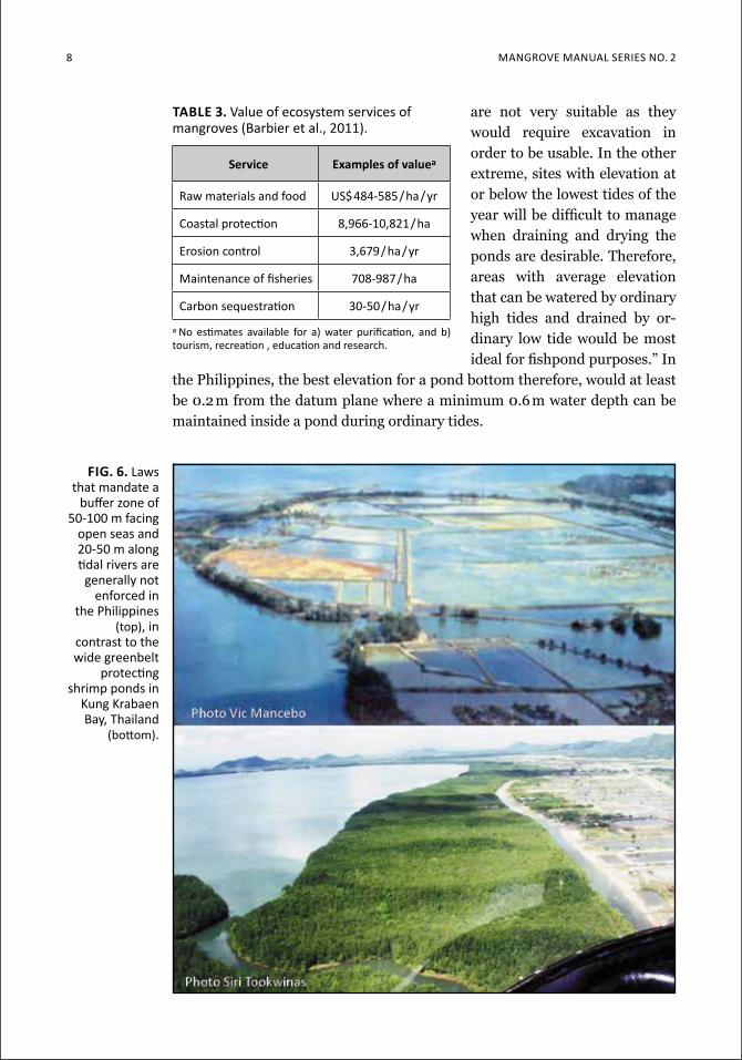
fig. 6. Laws that mandate a
buffer zone of 50-100 m facing
open seas and 20-50 m along tidal rivers are
generally not enforced in
the philippines (top), in
contrast to the wide greenbelt
protecting shrimp ponds in
kung krabaen Bay, thailand
(bottom).
table 3. value of ecosystem services of mangroves (Barbier et al., 2011).
service examples of valuea
raw materials and food uS$484-585/ha/yr
coastal protection 8,966-10,821/ha
erosion control 3,679/ha/yr
Maintenance of fisheries 708-987/ha
carbon sequestration 30-50/ha/yr
a no estimates available for a) water purification, and b) tourism, recreation , education and research.
Manual on Mangrove reverSion of aBandoned and illegal BrackiSHwater fiSHPondS 9
As a result, most fishponds are shallow (0.6-0.9 m) and suitable only for ex-tensive culture that depends on natural food and tidal flow (Primavera, 1993). When shrimp farming became popular throughout Asia between the 1980s and the mid-1990s, many ponds were deepened for semi-intensive and inten-sive shrimp farming. These excavations showed that intertidal areas are not the best sites for intensive aquaculture since the only advantage of tidal ex-change is greatly outweighed by problems of acidity (when mangrove soils are exposed) and seepage (which makes water depth difficult to maintain and also compromises biosecurity). Therefore new investments for shrimp ponds in the 1990s shifted to the upper intertidal and supra-tidal areas – often agricultural lands planted to sugar cane and other crops. Such culture ponds are rare ex-ceptions to the generally intertidal location of brackishwater ponds and can be found mostly in Negros Occidental where nonproductive haciendas (plan-tations) were converted to aquaculture. When these ponds were abandoned after the Shrimp Fever went bust, they could not be planted to mangroves due to their high elevation, and their private ownership placed them outside the jurisdiction of the Bureau of Fisheries and Aquatic Resources (BFAR).
Food security was the ostensible justification for clearing mangroves to con-struct fishponds. Therefore such mangrove cutting was sanctioned and even encouraged by the government (as early as under American rule) through a pond lease system (Yap, 1999). To this day, the attitude persists that pond conversion was the best use of such idle and unproductive mangrove swamps (as they were called at the time) to some extent among the general public, but not the government (at least officially). Looking back, just how much do brack-ishwater fishponds contribute to food security and the economy as a whole? As it turns out, their contribution is minimal owing to lack of seriousness among
fig. 7. abandoned
fishponds, located in
the middle to upper intertidal zone, are more easily reverted to mangroves than exposed seafront sites
in the lower intertidal to
subtidal, but they have
problematic tenurial issues.
10 Mangrove Manual SerieS no. 2
pond operators to efficiently use land and water resources for optimal fish pro-duction (Box 2). If all 239,000 ha of ponds were to be reverted to mangroves, the lost production can be replaced by some 23,000 units of 10 m x 10 m fish cages in lakes and coves (with the caveat that they follow environmental guide-lines). Pond reversion to mangroves will not compromise food security, after all. Instead, it will bring back coastal protection, fisheries catches and other ecosystem services valued at $14,000-16,000/ha.
e. the fla systeM and other tenurial instruMents
Brackishwater fishponds preceded the basic laws regulating their development and operation. By the time Act 4003 (also known as the Fisheries Act) was pro-mulgated on 5 December 1932, brackishwater ponds were already operating in the Philippines, particularly along the shores of Manila Bay. Act 4003 pro-vided two ways for claiming, developing and operating fishponds in mangrove forests: 1) Special Fishpond Permits or SFP and 2) a Fishpond Lease Agree-ment or FLA (Table 4). Much later, the SFP system was abolished leaving only the FLA as tenurial instrument for brackishwater fishponds in public lands. (To provide wider background, other Philippine mangrove laws are enumer-ated in Appendix 1.)
The release for pond construction of wide mangrove areas was mainly through the FLA system. The process for granting a FLA starts with the Department of Environment and Natural Resources (DENR) which has jurisdiction over
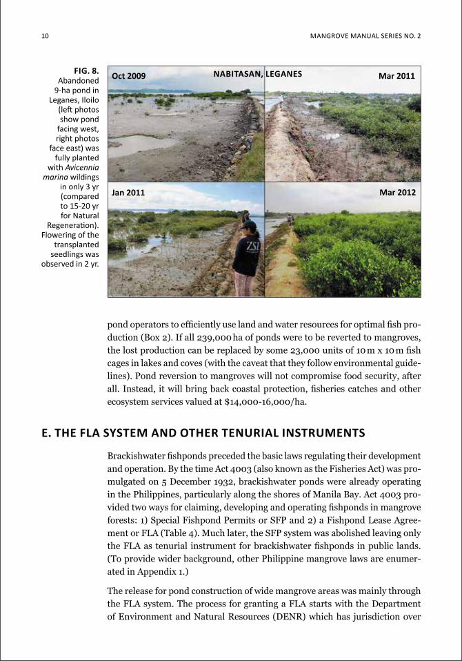
fig. 8. abandoned
9-ha pond in leganes, iloilo
(left photos show pond
facing west, right photos
face east) was fully planted
with Avicennia marina wildings
in only 3 yr (compared to 15-20 yr for natural
regeneration). flowering of the
transplanted seedlings was
observed in 2 yr.
nabitasan, leganesoct 2009 Mar 2011
Jan 2011 Mar 2012
ManuaL on Mangrove reverSion of abandoned and iLLegaL brackiShwaTer fiShpondS 11
Fig. 9. early ponds for extensive
milkfish culture were developed in the middle to upper intertidal zones (range of
ordinary high tides) for tidal
water exchange to avoid the
additional expense of
pumping, and ensure total
drainage (from Jamandre and
rabanal, 1975).
all forest lands. With the technical assistance of BFAR, DENR classified man-grove areas as suitable for fishpond development and released these to BFAR for leasing to private individuals with very liberal terms in duration and area under the FLA system. The duration of each FLA started with a period of 10 years renewable up to a maximum of 50 years under the 1937 Commonwealth Government (Table 4). This was increased to 20 years in 1960 and finally to the present 25 years in 1979. The 25-year duration for each lease period and the 50-year maximum was affirmed by the 1998 Philippine Fisheries Code. As for area, the law set limits for individuals of 200 ha (later reduced to 100 ha, 50 ha, then 25 ha), and also 200 ha for corporations (increased to 400 ha, then reduced to 250 ha). Area limits were often circumvented by an applicant using the names of several family members to apply for one large tract. Thus
box 2. brackishwater ponds and food Security
the country’s brackishwater fishponds produced a total of 318,502 metric tons of all species (231,044 mt from milkfish) with total value of PhP46.3 billion in 2012, according to the Bureau of agricultural Statistics of the da. with total pond area estimated at 239,000 ha, this amounts to a yield of only 1.33 metric tons/ha/yr of which barely 1.0 mt comes from milkfish. in contrast, a 10 m x 10 m fish cage set in the open sea can produce at least 10 mt of milkfish in one year. this means a cage occupying an area that is 1/100th of a hectare (=100 sq m) is able to produce 10 times more milkfish than one hectare of brackishwater fishpond. the latter is a very inefficient use of land and water resources. in terms of total fish supply, brackishwater fishponds contribute only 10.2% by volume and 20.4% by value (due to the higher value of milkfish and shrimps compared to most species in commercial and municipal fisheries). the contribution from brackishwater ponds in terms of fish self-sufficiency and food security is not critical and can be replaced by production in fish cages and pens.
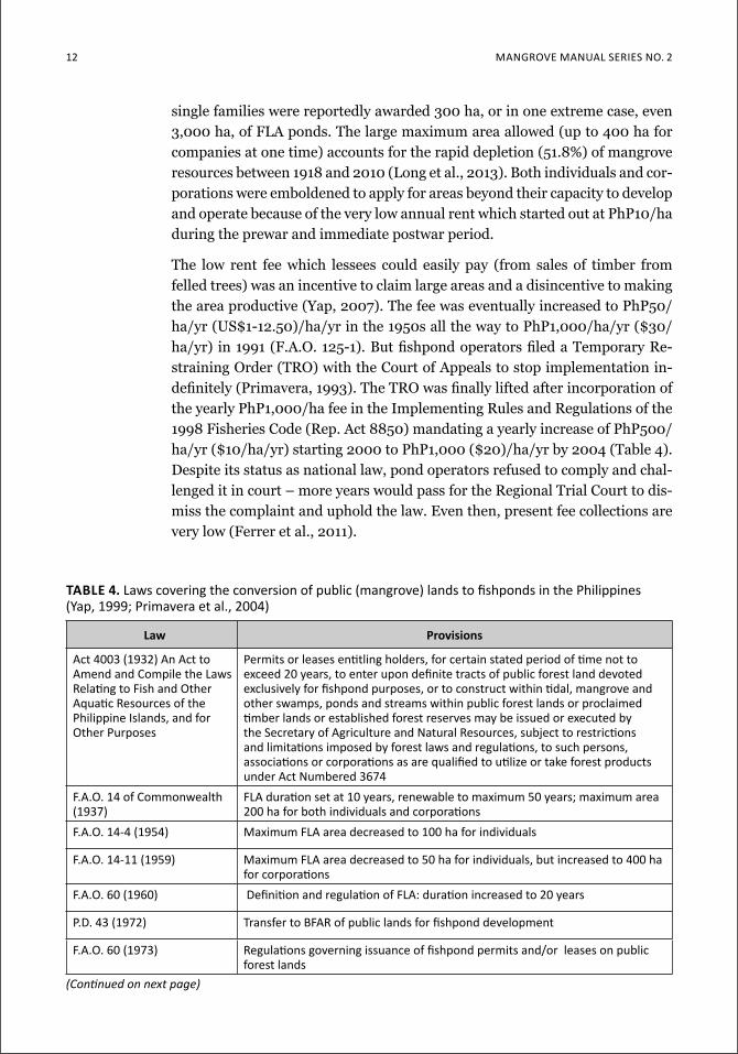
12 Mangrove Manual SerieS no. 2
law provisions
act 4003 (1932) an act to amend and compile the Laws relating to fish and other aquatic resources of the Philippine islands, and for other purposes
Permits or leases entitling holders, for certain stated period of time not to exceed 20 years, to enter upon definite tracts of public forest land devoted exclusively for fishpond purposes, or to construct within tidal, mangrove and other swamps, ponds and streams within public forest lands or proclaimed timber lands or established forest reserves may be issued or executed by the Secretary of agriculture and natural resources, subject to restrictions and limitations imposed by forest laws and regulations, to such persons, associations or corporations as are qualified to utilize or take forest products under act numbered 3674
f.a.o. 14 of commonwealth (1937)
fla duration set at 10 years, renewable to maximum 50 years; maximum area 200 ha for both individuals and corporations
f.a.o. 14-4 (1954) Maximum fla area decreased to 100 ha for individuals
f.a.o. 14-11 (1959) Maximum fla area decreased to 50 ha for individuals, but increased to 400 ha for corporations
f.a.o. 60 (1960) definition and regulation of fla: duration increased to 20 years
P.d. 43 (1972) transfer to Bfar of public lands for fishpond development
f.a.o. 60 (1973) regulations governing issuance of fishpond permits and/or leases on public forest lands
table 4. laws covering the conversion of public (mangrove) lands to fishponds in the Philippines (Yap, 1999; Primavera et al., 2004)
(Continuedonnextpage)
single families were reportedly awarded 300 ha, or in one extreme case, even 3,000 ha, of FLA ponds. The large maximum area allowed (up to 400 ha for companies at one time) accounts for the rapid depletion (51.8%) of mangrove resources between 1918 and 2010 (Long et al., 2013). Both individuals and cor-porations were emboldened to apply for areas beyond their capacity to develop and operate because of the very low annual rent which started out at PhP10/ha during the prewar and immediate postwar period.
The low rent fee which lessees could easily pay (from sales of timber from felled trees) was an incentive to claim large areas and a disincentive to making the area productive (Yap, 2007). The fee was eventually increased to PhP50/ha/yr (US$1-12.50)/ha/yr in the 1950s all the way to PhP1,000/ha/yr ($30/ha/yr) in 1991 (F.A.O. 125-1). But fishpond operators filed a Temporary Re-straining Order (TRO) with the Court of Appeals to stop implementation in-definitely (Primavera, 1993). The TRO was finally lifted after incorporation of the yearly PhP1,000/ha fee in the Implementing Rules and Regulations of the 1998 Fisheries Code (Rep. Act 8850) mandating a yearly increase of PhP500/ha/yr ($10/ha/yr) starting 2000 to PhP1,000 ($20)/ha/yr by 2004 (Table 4). Despite its status as national law, pond operators refused to comply and chal-lenged it in court – more years would pass for the Regional Trial Court to dis-miss the complaint and uphold the law. Even then, present fee collections are very low (Ferrer et al., 2011).
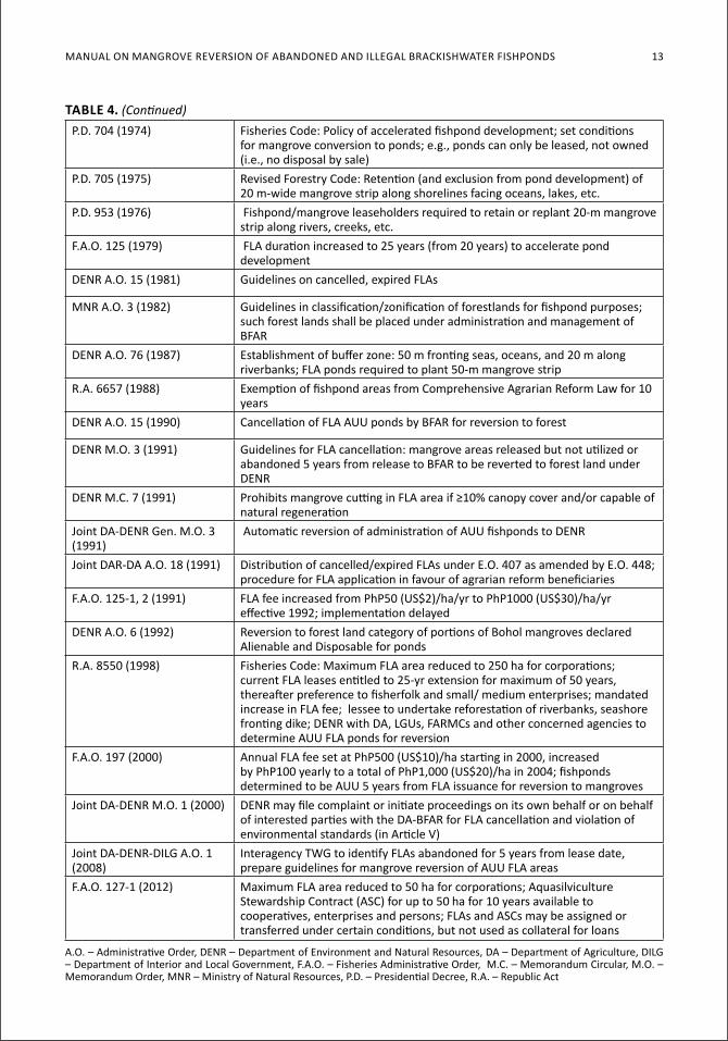
Manual on Mangrove reverSion of aBandoned and illegal BrackiSHwater fiSHPondS 13
P.d. 704 (1974) fisheries code: Policy of accelerated fishpond development; set conditions for mangrove conversion to ponds; e.g., ponds can only be leased, not owned (i.e., no disposal by sale)
P.d. 705 (1975) revised forestry code: retention (and exclusion from pond development) of 20 m-wide mangrove strip along shorelines facing oceans, lakes, etc.
P.d. 953 (1976) fishpond/mangrove leaseholders required to retain or replant 20-m mangrove strip along rivers, creeks, etc.
f.a.o. 125 (1979) fla duration increased to 25 years (from 20 years) to accelerate pond development
denr a.o. 15 (1981) guidelines on cancelled, expired flas
Mnr a.o. 3 (1982) guidelines in classification/zonification of forestlands for fishpond purposes; such forest lands shall be placed under administration and management of bfar
denr a.o. 76 (1987) establishment of buffer zone: 50 m fronting seas, oceans, and 20 m along riverbanks; fla ponds required to plant 50-m mangrove strip
r.a. 6657 (1988) exemption of fishpond areas from comprehensive agrarian reform law for 10 years
denr a.o. 15 (1990) cancellation of fla auu ponds by Bfar for reversion to forest
denr M.o. 3 (1991) guidelines for fla cancellation: mangrove areas released but not utilized or abandoned 5 years from release to Bfar to be reverted to forest land under denr
denr M.c. 7 (1991) Prohibits mangrove cutting in fla area if ≥10% canopy cover and/or capable of natural regeneration
Joint da-denr gen. M.o. 3 (1991)
automatic reversion of administration of auu fishponds to denr
Joint dar-da a.o. 18 (1991) distribution of cancelled/expired flas under e.o. 407 as amended by e.o. 448; procedure for fla application in favour of agrarian reform beneficiaries
f.a.o. 125-1, 2 (1991) fla fee increased from PhP50 (uS$2)/ha/yr to PhP1000 (uS$30)/ha/yr effective 1992; implementation delayed
denr a.o. 6 (1992) reversion to forest land category of portions of Bohol mangroves declared alienable and disposable for ponds
r.a. 8550 (1998) fisheries code: Maximum fla area reduced to 250 ha for corporations; current fla leases entitled to 25-yr extension for maximum of 50 years, thereafter preference to fisherfolk and small/ medium enterprises; mandated increase in fla fee; lessee to undertake reforestation of riverbanks, seashore fronting dike; denr with da, lgus, farMcs and other concerned agencies to determine auu fla ponds for reversion
f.a.o. 197 (2000) annual fla fee set at PhP500 (uS$10)/ha starting in 2000, increased by PhP100 yearly to a total of PhP1,000 (uS$20)/ha in 2004; fishponds determined to be auu 5 years from fla issuance for reversion to mangroves
Joint da-denr M.o. 1 (2000) denr may file complaint or initiate proceedings on its own behalf or on behalf of interested parties with the da-Bfar for fla cancellation and violation of environmental standards (in article v)
Joint da-denr-dilg a.o. 1 (2008)
interagency twg to identify flas abandoned for 5 years from lease date, prepare guidelines for mangrove reversion of auu fla areas
f.a.o. 127-1 (2012) Maximum fla area reduced to 50 ha for corporations; aquasilviculture Stewardship contract (aSc) for up to 50 ha for 10 years available to cooperatives, enterprises and persons; flas and aScs may be assigned or transferred under certain conditions, but not used as collateral for loans
a.o. – administrative order, denr – department of environment and natural resources, da – department of agriculture, dilg – department of interior and local government, f.a.o. – fisheries administrative order, M.c. – Memorandum circular, M.o. – Memorandum order, Mnr – Ministry of natural resources, P.d. – Presidential decree, r.a. – republic act
table 4. (Continued)
14 Mangrove Manual SerieS no. 2
The low yearly fee to lease public land (mangroves) for aquaculture was meant to encourage pond development. However, unscrupulous parties obtained leases for use as collateral (in lieu of land title certificates) to obtain pond de-velopment loans from the Development Bank of the Philippines (DBP) and its precursor, the Rehabilitation Finance Corporation (RFC), with no intention to develop the ponds nor pay back the loans. The DBP has records for three sets of loans between 1947 to 1979: a) 1947-71 – 2,082 loans totalling PhP37.5 million ($775,000) for 35,913 ha of FLA ponds; b) 1975-76 – 967 loans total-ling PhP36.5 million ($754,000) for 6,769 ha of ponds; and c) 1979 – 363 loans totalling PhP50.6 million ($1.0 million) for 5,750 ha of ponds (Yap, unpub.). Over the 1947-79 period (minus 5 years with no data available), a total of PhP124.6 million was released for 3,412 loans granted to private enti-ties using 48,432 ha of public land as collateral (Yap, 2007). Most lessees re-neged on their loan obligations and simply allowed the DBP to foreclose their FLA holdings. In this manner did thousands of hectares of mangroves and/or ponds pass from public domain to private ownership because (some) FLAs were obtained for financing (not aquaculture): the lessee got something for nothing – free money (unpaid loan) – using FLA rights and the bank got FLA rights for its money. Both lessee and bank were winners, but the government and the people lost public land, mostly mangroves.
There is no official inventory on what happened to public lands “mortgaged” to the DBP. It appears that many, if not most, of the borrowers under the DBP Special Fishpond Loan program, were not serious fish farmers but simply “took the money and ran,” based on the physical state of the ponds they developed. After cutting the mangroves and putting up dikes to comply with the minimum requirements for classification as “developed fishpond,” many of these ponds were understocked and underutilized since the operators had no more funds to sustain operations.
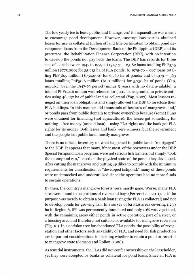
By then, the country’s mangrove forests were mostly gone. Worse, many FLA sites were found to be portions of rivers and bays (Ferrer et al., 2011), as if the purpose was merely to obtain a bank loan (using the FLA as collateral) and not to develop ponds for growing fish. In a survey of 62 FLA areas covering 1,239 ha in Region 6, 8% was permanently inundated and only 10% was vegetated, with the remaining areas either ponds in active operation, part of a river, or a housing area and therefore not suitable or available for mangrove reversion (Fig. 10). In a decision tree for abandoned FLA ponds, the possibility of reveg-etation and other factors such as validity of FLA, and need for fish production are important considerations in deciding whether to retain a pond or revert it to mangrove state (Samson and Rollon, 2008).
As tenurial instruments, the FLAs did not confer ownership on the leaseholder, yet they were accepted by banks as collateral for pond loans. Since an FLA is
ManuaL on Mangrove reverSion of abandoned and iLLegaL brackiShwaTer fiShpondS 15
not transferable, the DBP should have officially returned foreclosed FLA sites to BFAR, but institutional inertia may have prevented it from doing so. The DBP apparently held on to the FLA papers in the same manner that they keep certificates of title for mortgaged properties that are foreclosed. Many of such fishponds are reportedly claimed by enterprising operators, albeit illegally. In the first place, BFAR should not have endorsed the loan applications which represent the use of public land by private persons.
Aside from serving as loan collaterals, FLA papers were commonly used to apply for a sales patent so the leased pond could be issued a certificate of title. This practice was put to a stop with the issuance of Pres. Decree 704 on May 16, 1974, which stated that “no public lands suitable for fishpond purposes shall be disposed by sale.” The decree further provided that “only fishpond sales patent already processed and approved on or before November 9, 1972, shall be given due course subject to the condition that such application covers a fully developed fishpond not exceeding twenty-four (24) hectares.” Yet it is public knowledge that many fishpond areas continue to be released, “disposed by sale” and given titles long after the 1972 statutory date.
Legally speaking, fishponds are only covered by two tenurial instruments: a) FLAs for government ponds, and b) certificates of title for privatized ponds. A third instrument known as the Right of Usufruct is rare and usually issued to government institutions, local government units (LGUs) or state univer-sities and colleges (SUCs), while the ponds technically remain public lands.
Fig. 10. a survey of 62 fLa areas (in
solid green lines) in region
6 found 8% to be permanently
inundated portions of
rivers and bays (ferrer
et al., 2011). it appears the
leases were obtained as
collateral for bank loans, and
not for pond development.
16 Mangrove Manual SerieS no. 2
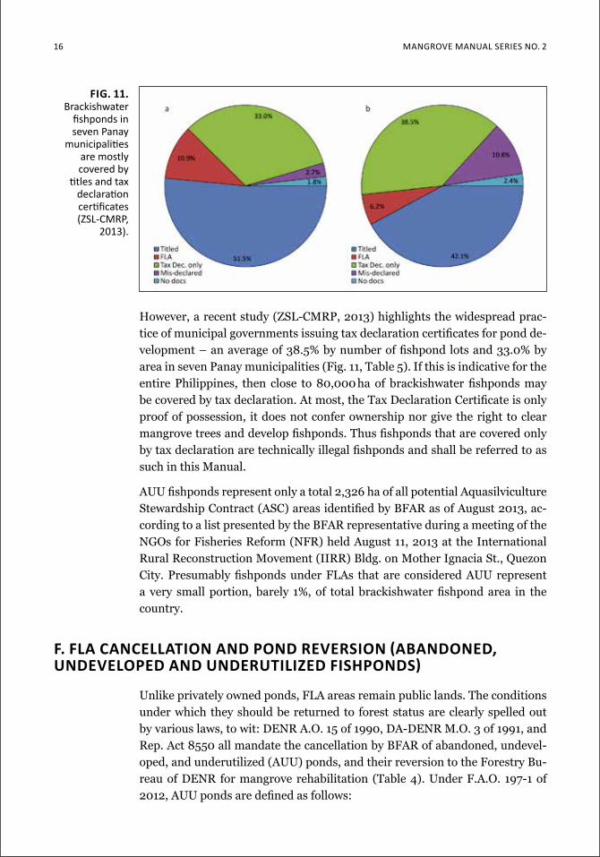
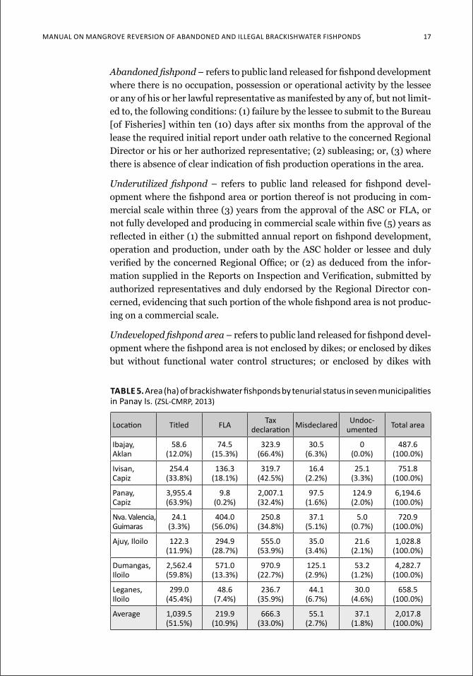
However, a recent study (ZSL-CMRP, 2013) highlights the widespread prac-tice of municipal governments issuing tax declaration certificates for pond de-velopment – an average of 38.5% by number of fishpond lots and 33.0% by area in seven Panay municipalities (Fig. 11, Table 5). If this is indicative for the entire Philippines, then close to 80,000 ha of brackishwater fishponds may be covered by tax declaration. At most, the Tax Declaration Certificate is only proof of possession, it does not confer ownership nor give the right to clear mangrove trees and develop fishponds. Thus fishponds that are covered only by tax declaration are technically illegal fishponds and shall be referred to as such in this Manual.
AUU fishponds represent only a total 2,326 ha of all potential Aquasilviculture Stewardship Contract (ASC) areas identified by BFAR as of August 2013, ac-cording to a list presented by the BFAR representative during a meeting of the NGOs for Fisheries Reform (NFR) held August 11, 2013 at the International Rural Reconstruction Movement (IIRR) Bldg. on Mother Ignacia St., Quezon City. Presumably fishponds under FLAs that are considered AUU represent a very small portion, barely 1%, of total brackishwater fishpond area in the country.
F. Fla CanCellaTion and Pond reverSion (abandoned, undeveloPed and underuTilized FiShPondS)
Unlike privately owned ponds, FLA areas remain public lands. The conditions under which they should be returned to forest status are clearly spelled out by various laws, to wit: DENR A.O. 15 of 1990, DA-DENR M.O. 3 of 1991, and Rep. Act 8550 all mandate the cancellation by BFAR of abandoned, undevel-oped, and underutilized (AUU) ponds, and their reversion to the Forestry Bu-reau of DENR for mangrove rehabilitation (Table 4). Under F.A.O. 197-1 of 2012, AUU ponds are defined as follows:
fig. 11. brackishwater
fishponds in seven panay
municipalities are mostly covered by
titles and tax declaration certificates (ZSl-cMrP,
2013).
ManuaL on Mangrove reverSion of abandoned and iLLegaL brackiShwaTer fiShpondS 17
Abandoned fishpond – refers to public land released for fishpond development where there is no occupation, possession or operational activity by the lessee or any of his or her lawful representative as manifested by any of, but not limit-ed to, the following conditions: (1) failure by the lessee to submit to the Bureau [of Fisheries] within ten (10) days after six months from the approval of the lease the required initial report under oath relative to the concerned Regional Director or his or her authorized representative; (2) subleasing; or, (3) where there is absence of clear indication of fish production operations in the area.
Underutilized fishpond – refers to public land released for fishpond devel-opment where the fishpond area or portion thereof is not producing in com-mercial scale within three (3) years from the approval of the ASC or FLA, or not fully developed and producing in commercial scale within five (5) years as reflected in either (1) the submitted annual report on fishpond development, operation and production, under oath by the ASC holder or lessee and duly verified by the concerned Regional Office; or (2) as deduced from the infor-mation supplied in the Reports on Inspection and Verification, submitted by authorized representatives and duly endorsed by the Regional Director con-cerned, evidencing that such portion of the whole fishpond area is not produc-ing on a commercial scale.
Undeveloped fishpond area – refers to public land released for fishpond devel-opment where the fishpond area is not enclosed by dikes; or enclosed by dikes but without functional water control structures; or enclosed by dikes with
table 5. area (ha) of brackishwater fishponds by tenurial status in seven municipalities in Panay is. (ZSl-cMrP, 2013)
location Titled fLa Tax declaration Misdeclared undoc-
umented Total area
ibajay, aklan
58.6 (12.0%)
74.5 (15.3%)
323.9 (66.4%)
30.5 (6.3%)
0 (0.0%)
487.6 (100.0%)
ivisan, capiz
254.4 (33.8%)
136.3 (18.1%)
319.7 (42.5%)
16.4 (2.2%)
25.1 (3.3%)
751.8 (100.0%)
Panay, capiz
3,955.4 (63.9%)
9.8 (0.2%)
2,007.1 (32.4%)
97.5 (1.6%)
124.9 (2.0%)
6,194.6 (100.0%)
nva. valencia, guimaras
24.1 (3.3%)
404.0 (56.0%)
250.8 (34.8%)
37.1 (5.1%)
5.0 (0.7%)
720.9 (100.0%)
ajuy, iloilo 122.3 (11.9%)
294.9 (28.7%)
555.0 (53.9%)
35.0 (3.4%)
21.6 (2.1%)
1,028.8 (100.0%)
dumangas, iloilo
2,562.4 (59.8%)
571.0 (13.3%)
970.9 (22.7%)
125.1 (2.9%)
53.2 (1.2%)
4,282.7 (100.0%)
leganes, iloilo
299.0 (45.4%)
48.6 (7.4%)
236.7 (35.9%)
44.1 (6.7%)
30.0 (4.6%)
658.5 (100.0%)
average 1,039.5(51.5%)
219.9(10.9%)
666.3(33.0%)
55.1(2.7%)
37.1(1.8%)
2,017.8(100.0%)
18 Mangrove Manual SerieS no. 2
functional water control structures but the water level required for production on commercial scale cannot be maintained either by high tides or pumping; or a larger area enclosed only with a simple perimeter dike which has not been subdivided, which may or may not be vegetated with mangrove species.
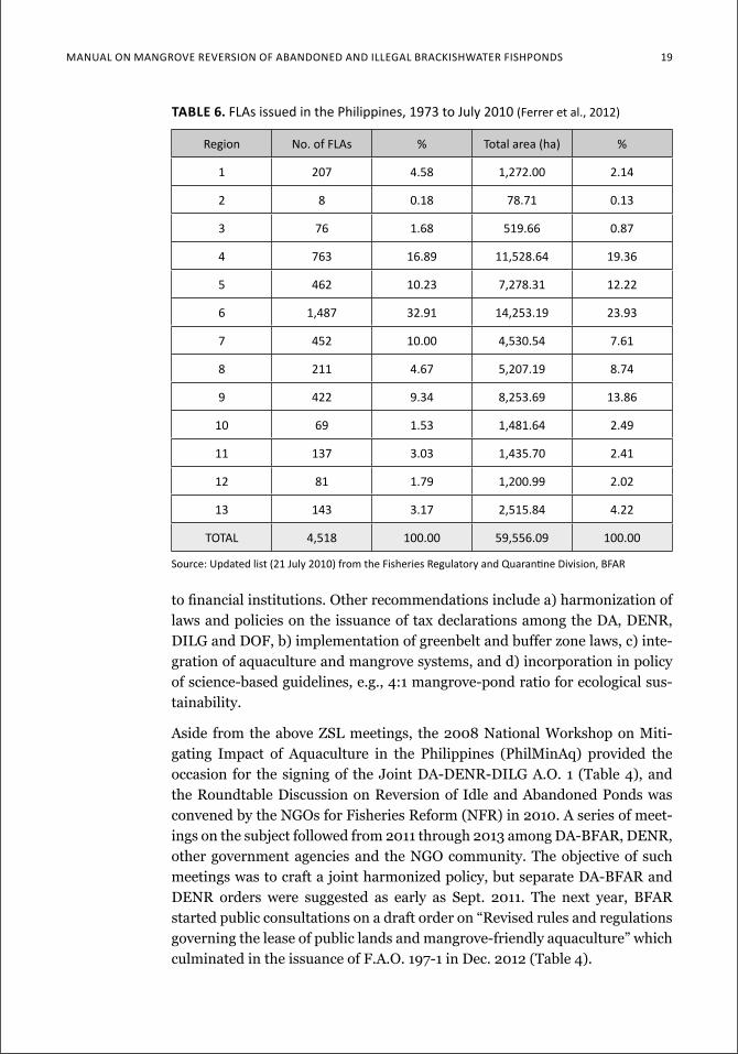
Of a total 4,518 FLAs issued nationwide as of July 2010 covering 59,556 ha, Region 6 has the highest number (32.9%) and area (23.9%) as indicated in Table 6. Surprisingly, only 63 or 4.2% of 1,487 FLAs in Region 6 have been cancelled despite a high incidence of lease violations, e.g., failure to submit regular production records and rampant subleasing (Ferrer et al., 2011). Other common grounds for FLA cancellation are: a) failure to pay arrears on rentals and surcharges, b) absence of improvements/ abandonment of area, c) non-suitability of area for fishpond purposes, and e) undeveloped/ abandoned area with mangrove vegetation. The factors behind such low rate of cancellation in Region 6 include lack of guidelines on FLA cancellation, ‘powerful, connected and untouchable’ lessees, poor monitoring and recording and limited resourc-es on the part of BFAR (Ferrer et al., 2011). The last factor may partly explain why it took up to 14 years to cancel an FLA in the region, with an average of 1.3 to 5.6 years for the five Region 6 provinces. Moreover, of 68 cancelled FLAs in Region 6, 11 were declared open and available to new applicants, rather than reverted to the Forestry Bureau (Ferrer et al., 2012).
To move forward the process of FLA cancellation and biophysical reversion of AUU fishponds to mangroves, the Community-based Mangrove Rehabilita-tion Project of the Zoological Society of London (ZSL-CMRP) has organized seven conferences over the years, some in collaboration with the Deutsche Ge-sellschaft für Internationale Zusammenarbeit or GIZ (formerly the German Technical Cooperation or GTZ):
a) Workshop on Pond-Mangrove Rehabilitation in Iloilo City, September 2007b) Mangrove Seminar-Workshop in Tangalan, Aklan, August 2008c) Workshop on Mangrove/Pond Governance in Iloilo City, December 2008d) Seminar-Workshop on Fishpond Lease Agreement Cancellation and Rever-
sion to Mangrove Forest in Iloilo City, July 2010 (Primavera, 2011)e) P.O. Conference on Mangrove Conservation, Rehabilitation and Climate
Change in Iloilo City, October 2010f) National Mangrove Conference in Iloilo City, December 2012g) Seminar-Workshop on Brackishwater Pond Database in Iloilo City, April
2013.
Petitions and recommendations from the above conferences and seminars are featured in Appendices 2A-2E. Running through all these is a consistent call for the immediate implementation of laws that mandate the FLA cancellation of AUU ponds and their reversion to mangroves, including an inventory of all FLA/other culture ponds and a review of the practice of assigning FLA rights
Manual on Mangrove reverSion of aBandoned and illegal BrackiSHwater fiSHPondS 19
to financial institutions. Other recommendations include a) harmonization of laws and policies on the issuance of tax declarations among the DA, DENR, DILG and DOF, b) implementation of greenbelt and buffer zone laws, c) inte-gration of aquaculture and mangrove systems, and d) incorporation in policy of science-based guidelines, e.g., 4:1 mangrove-pond ratio for ecological sus-tainability.
Aside from the above ZSL meetings, the 2008 National Workshop on Miti-gating Impact of Aquaculture in the Philippines (PhilMinAq) provided the occasion for the signing of the Joint DA-DENR-DILG A.O. 1 (Table 4), and the Roundtable Discussion on Reversion of Idle and Abandoned Ponds was convened by the NGOs for Fisheries Reform (NFR) in 2010. A series of meet-ings on the subject followed from 2011 through 2013 among DA-BFAR, DENR, other government agencies and the NGO community. The objective of such meetings was to craft a joint harmonized policy, but separate DA-BFAR and DENR orders were suggested as early as Sept. 2011. The next year, BFAR started public consultations on a draft order on “Revised rules and regulations governing the lease of public lands and mangrove-friendly aquaculture” which culminated in the issuance of F.A.O. 197-1 in Dec. 2012 (Table 4).
table 6. flas issued in the Philippines, 1973 to July 2010 (ferrer et al., 2012)
region no. of flas % total area (ha) %
1 207 4.58 1,272.00 2.14
2 8 0.18 78.71 0.13
3 76 1.68 519.66 0.87
4 763 16.89 11,528.64 19.36
5 462 10.23 7,278.31 12.22
6 1,487 32.91 14,253.19 23.93
7 452 10.00 4,530.54 7.61
8 211 4.67 5,207.19 8.74
9 422 9.34 8,253.69 13.86
10 69 1.53 1,481.64 2.49
11 137 3.03 1,435.70 2.41
12 81 1.79 1,200.99 2.02
13 143 3.17 2,515.84 4.22
ToTaL 4,518 100.00 59,556.09 100.00
Source: updated list (21 July 2010) from the fisheries regulatory and Quarantine division, Bfar
20 Mangrove Manual SerieS no. 2
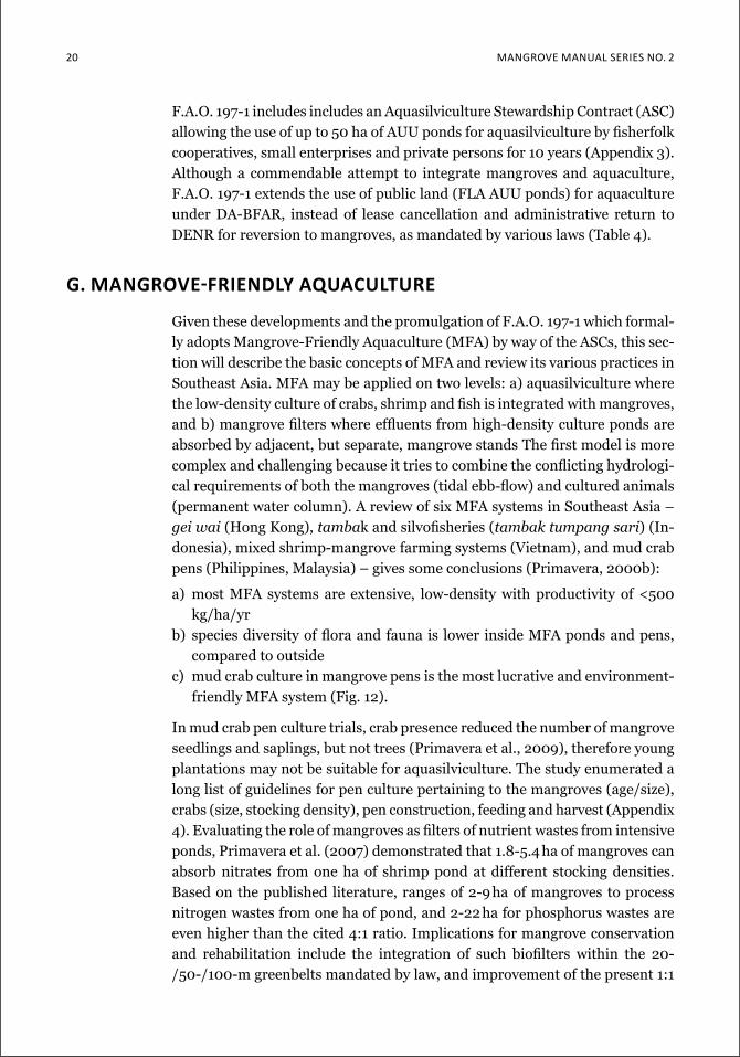
F.A.O. 197-1 includes includes an Aquasilviculture Stewardship Contract (ASC) allowing the use of up to 50 ha of AUU ponds for aquasilviculture by fisherfolk cooperatives, small enterprises and private persons for 10 years (Appendix 3). Although a commendable attempt to integrate mangroves and aquaculture, F.A.O. 197-1 extends the use of public land (FLA AUU ponds) for aquaculture under DA-BFAR, instead of lease cancellation and administrative return to DENR for reversion to mangroves, as mandated by various laws (Table 4).
g. Mangrove-Friendly aquaCulTure
Given these developments and the promulgation of F.A.O. 197-1 which formal-ly adopts Mangrove-Friendly Aquaculture (MFA) by way of the ASCs, this sec-tion will describe the basic concepts of MFA and review its various practices in Southeast Asia. MFA may be applied on two levels: a) aquasilviculture where the low-density culture of crabs, shrimp and fish is integrated with mangroves, and b) mangrove filters where effluents from high-density culture ponds are absorbed by adjacent, but separate, mangrove stands The first model is more complex and challenging because it tries to combine the conflicting hydrologi-cal requirements of both the mangroves (tidal ebb-flow) and cultured animals (permanent water column). A review of six MFA systems in Southeast Asia – gei wai (Hong Kong), tambak and silvofisheries (tambak tumpang sari) (In-donesia), mixed shrimp-mangrove farming systems (Vietnam), and mud crab pens (Philippines, Malaysia) – gives some conclusions (Primavera, 2000b):
a) most MFA systems are extensive, low-density with productivity of <500 kg/ha/yr
b) species diversity of flora and fauna is lower inside MFA ponds and pens, compared to outside
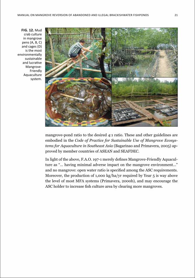
c) mud crab culture in mangrove pens is the most lucrative and environment-friendly MFA system (Fig. 12).
In mud crab pen culture trials, crab presence reduced the number of mangrove seedlings and saplings, but not trees (Primavera et al., 2009), therefore young plantations may not be suitable for aquasilviculture. The study enumerated a long list of guidelines for pen culture pertaining to the mangroves (age/size), crabs (size, stocking density), pen construction, feeding and harvest (Appendix 4). Evaluating the role of mangroves as filters of nutrient wastes from intensive ponds, Primavera et al. (2007) demonstrated that 1.8-5.4 ha of mangroves can absorb nitrates from one ha of shrimp pond at different stocking densities. Based on the published literature, ranges of 2-9 ha of mangroves to process nitrogen wastes from one ha of pond, and 2-22 ha for phosphorus wastes are even higher than the cited 4:1 ratio. Implications for mangrove conservation and rehabilitation include the integration of such biofilters within the 20-/50-/100-m greenbelts mandated by law, and improvement of the present 1:1
Manual on Mangrove reverSion of aBandoned and illegal BrackiSHwater fiSHPondS 21
mangrove-pond ratio to the desired 4:1 ratio. These and other guidelines are embodied in the Code of Practice for Sustainable Use of Mangrove Ecosys-tems for Aquaculture in Southeast Asia (Bagarinao and Primavera, 2005) ap-proved by member countries of ASEAN and SEAFDEC.
In light of the above, F.A.O. 197-1 merely defines Mangrove-Friendly Aquacul-ture as “… having minimal adverse impact on the mangrove environment…” and no mangrove: open water ratio is specified among the ASC requirements. Moreover, the production of 1,000 kg/ha/yr required by Year 5 is way above the level of most MFA systems (Primavera, 2000b), and may encourage the ASC holder to increase fish culture area by clearing more mangroves.
Fig. 12. Mud crab culture in mangrove
pens (a, B, c) and cages (d)
is the most environmentally
sustainable and lucrative
Mangrove-friendly
aquaculture system.
22 Mangrove Manual SerieS no. 2
inventory of brackishwater pondsTo attain the 4:1 mangrove-pond ratio, there is need to focus on reverting abandoned ponds to mangroves. But FLA fishponds cover less than 80,000 ha (Fig. 11) of which only a portion are abandoned, meaning only a few may be available for reversion. One way to increase the area for reversion is to in-clude fishponds with questionable documentation or none at all, and prioritize these. But to do so, there is need to identify and know the location of these poorly documented/undocumented ponds – which can only be done by com-piling a database which, so far, is not available from the government.
A. PreliminAry StePS
The database will need many maps and lists (Table 6) from various LGU of-fices and central/regional branches of national agencies. Prior information from the staff of these offices about the data retrieval process, e.g., through courtesy calls to the mayor and regional director, will streamline activities to follow. Phase 2 of the ACCCoast Project organized an orientation workshop for each province convening officials from the LGUs (e.g., Municipal Assessor’s Office) and regional offices (e.g., DENR Land Management Section) who are gatekeepers for the needed data.
B. Zero to minimum ContACt APProACh
A fishpond inventory should be conducted with zero or very little contact with pond operators and caretakers as much as possible. Most pond opera-
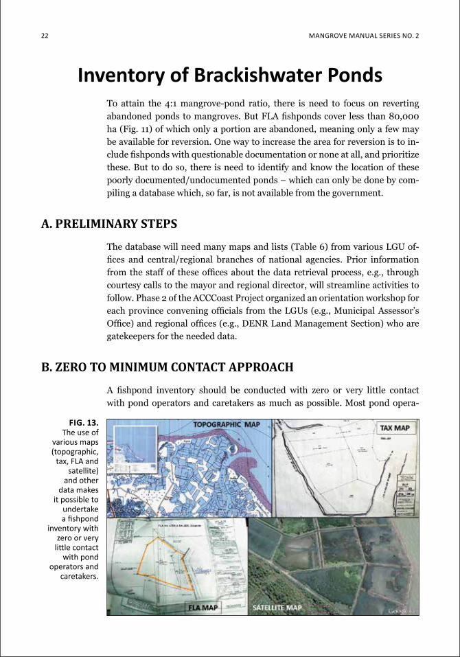
fig. 13. the use of
various maps (topographic,
tax, fla and satellite)
and other data makes
it possible to undertake a fishpond
inventory with zero or very
little contact with pond
operators and caretakers.
Manual on Mangrove reverSion of aBandoned and illegal BrackiSHwater fiSHPondS 23
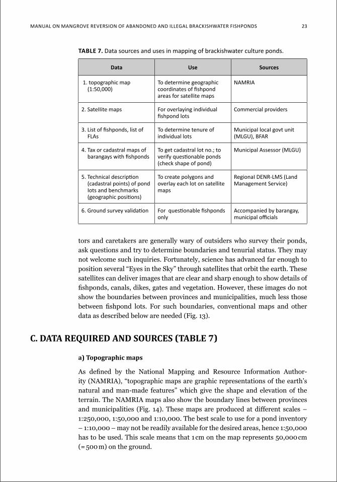
table 7. data sources and uses in mapping of brackishwater culture ponds.
data use sources
1. topographic map (1:50,000)
To determine geographic coordinates of fishpond areas for satellite maps
naMria
2. Sateiiite maps for overlaying individual fishpond lots
commercial providers
3. list of fishponds, list of fLas
to determine tenure of individual lots
Municipai locai govt unit (Mlgu), Bfar
4. tax or cadastral maps of barangays with fishponds
to get cadastral lot no.; to verify questionable ponds (check shape of pond)
Municipal assessor (Mlgu)
5. technicai description (cadastrai points) of pond iots and benchmarks (geographic positions)
To create polygons and overlay each lot on satellite maps
regionai denr-LMS (Land Management Service)
6. ground survey validation for questionable fishponds only
accompanied by barangay, municipal officials
tors and caretakers are generally wary of outsiders who survey their ponds, ask questions and try to determine boundaries and tenurial status. They may not welcome such inquiries. Fortunately, science has advanced far enough to position several “Eyes in the Sky” through satellites that orbit the earth. These satellites can deliver images that are clear and sharp enough to show details of fishponds, canals, dikes, gates and vegetation. However, these images do not show the boundaries between provinces and municipalities, much less those between fishpond lots. For such boundaries, conventional maps and other data as described below are needed (Fig. 13).
C. Data RequiReD anD SouRCeS (table 7)
a) topographic maps
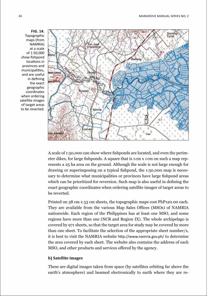
As defined by the National Mapping and Resource Information Author-ity (NAMRIA), “topographic maps are graphic representations of the earth’s natural and man-made features” which give the shape and elevation of the terrain. The NAMRIA maps also show the boundary lines between provinces and municipalities (Fig. 14). These maps are produced at different scales – 1:250,000, 1:50,000 and 1:10,000. The best scale to use for a pond inventory – 1:10,000 – may not be readily available for the desired areas, hence 1:50,000 has to be used. This scale means that 1 cm on the map represents 50,000 cm (= 500 m) on the ground.
24 Mangrove Manual SerieS no. 2
A scale of 1:50,000 can show where fishponds are located, and even the perim-eter dikes, for large fishponds. A square that is 1 cm x 1 cm on such a map rep-resents a 25 ha area on the ground. Although the scale is not large enough for drawing or superimposing on a typical fishpond, the 1:50,000 map is neces-sary to determine what municipalities or provinces have large fishpond areas which can be prioritized for reversion. Such map is also useful in defining the exact geographic coordinates when ordering satellite images of target areas to be reverted.
Printed on 38 cm x 53 cm sheets, the topographic maps cost PhP120.00 each. They are available from the various Map Sales Offices (MSOs) of NAMRIA nationwide. Each region of the Philippines has at least one MSO, and some regions have more than one (NCR and Region IX). The whole archipelago is covered by 971 sheets, so that the target area for study may be covered by more than one sheet. To facilitate the selection of the appropriate sheet number/s, it is best to visit the NAMRIA website http://www.namria.gov.ph/ to determine the area covered by each sheet. The website also contains the address of each MSO, and other products and services offered by the agency.
b) Satellite images
These are digital images taken from space (by satellites orbiting far above the earth’s atmosphere) and beamed electronically to earth where they are re-
fig. 14. Topographic maps (from
naMria) at a scale
of 1:50,000 show fishpond
locations in provinces and
municipalities, and are useful
in defining the exact
geographic coordinates
when ordering satellite images of target areas to be reverted.
Manual on Mangrove reverSion of aBandoned and illegal BrackiSHwater fiSHPondS 25
ceived by earth stations for storage in computers. There are many types of sat-ellite images available but a spatial resolution of ≤ 0.5 m is needed to identify pond areas (by super-imposing individual fishpond lots over such image). This resolution is the highest available for civilian use, which means that a ~0.5 m x 0.5 m unit is the smallest that can be mapped onto a single pixel within an image.
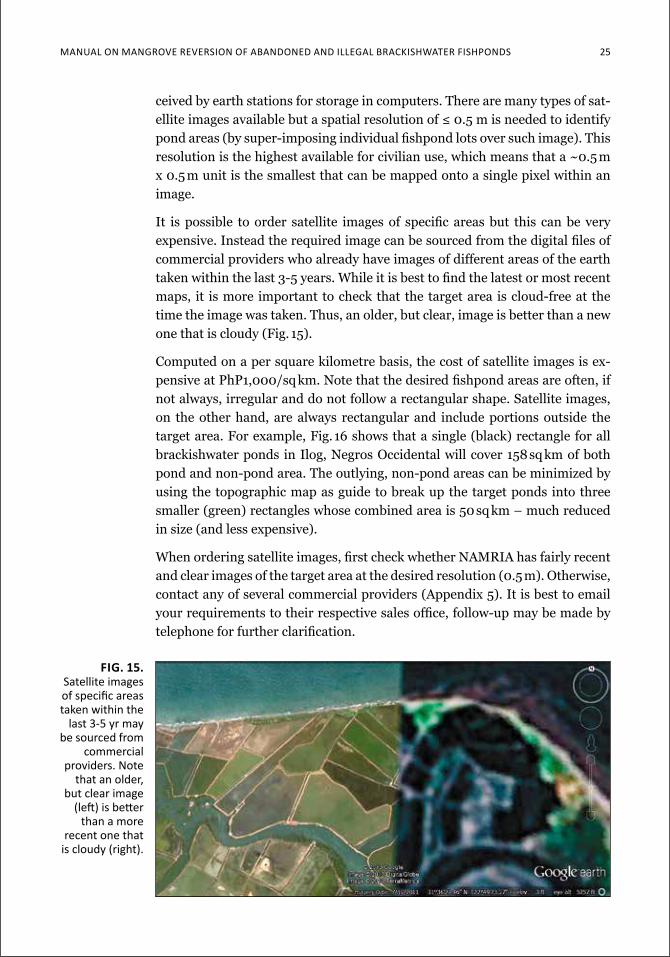
It is possible to order satellite images of specific areas but this can be very expensive. Instead the required image can be sourced from the digital files of commercial providers who already have images of different areas of the earth taken within the last 3-5 years. While it is best to find the latest or most recent maps, it is more important to check that the target area is cloud-free at the time the image was taken. Thus, an older, but clear, image is better than a new one that is cloudy (Fig. 15).
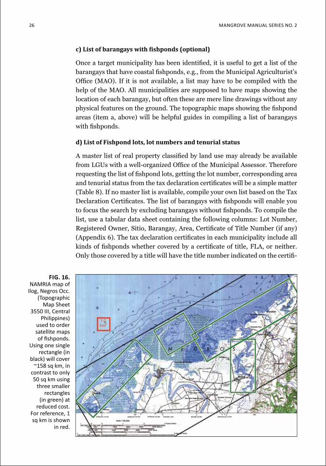
Computed on a per square kilometre basis, the cost of satellite images is ex-pensive at PhP1,000/sq km. Note that the desired fishpond areas are often, if not always, irregular and do not follow a rectangular shape. Satellite images, on the other hand, are always rectangular and include portions outside the target area. For example, Fig. 16 shows that a single (black) rectangle for all brackishwater ponds in Ilog, Negros Occidental will cover 158 sq km of both pond and non-pond area. The outlying, non-pond areas can be minimized by using the topographic map as guide to break up the target ponds into three smaller (green) rectangles whose combined area is 50 sq km – much reduced in size (and less expensive).
When ordering satellite images, first check whether NAMRIA has fairly recent and clear images of the target area at the desired resolution (0.5 m). Otherwise, contact any of several commercial providers (Appendix 5). It is best to email your requirements to their respective sales office, follow-up may be made by telephone for further clarification.
fig. 15. Satellite images of specific areas taken within the
last 3-5 yr may be sourced from
commercial providers. note
that an older, but clear image
(left) is better than a more
recent one that is cloudy (right).
26 Mangrove Manual SerieS no. 2
c) list of barangays with fishponds (optional)
Once a target municipality has been identified, it is useful to get a list of the barangays that have coastal fishponds, e.g., from the Municipal Agriculturist’s Office (MAO). If it is not available, a list may have to be compiled with the help of the MAO. All municipalities are supposed to have maps showing the location of each barangay, but often these are mere line drawings without any physical features on the ground. The topographic maps showing the fishpond areas (item a, above) will be helpful guides in compiling a list of barangays with fishponds.
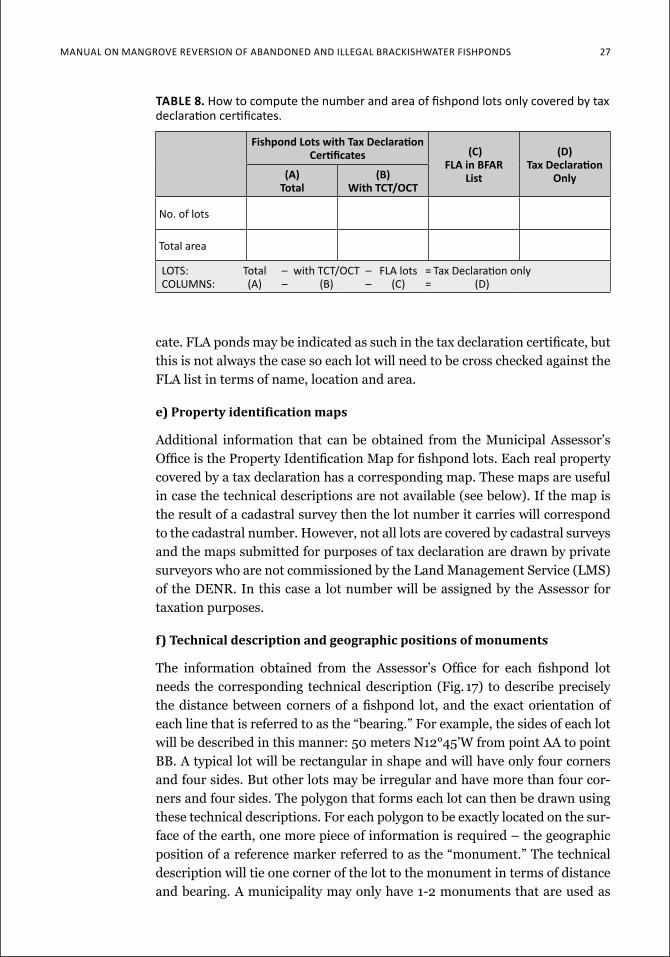
d) list of Fishpond lots, lot numbers and tenurial status
A master list of real property classified by land use may already be available from LGUs with a well-organized Office of the Municipal Assessor. Therefore requesting the list of fishpond lots, getting the lot number, corresponding area and tenurial status from the tax declaration certificates will be a simple matter (Table 8). If no master list is available, compile your own list based on the Tax Declaration Certificates. The list of barangays with fishponds will enable you to focus the search by excluding barangays without fishponds. To compile the list, use a tabular data sheet containing the following columns: Lot Number, Registered Owner, Sitio, Barangay, Area, Certificate of Title Number (if any) (Appendix 6). The tax declaration certificates in each municipality include all kinds of fishponds whether covered by a certificate of title, FLA, or neither. Only those covered by a title will have the title number indicated on the certifi-
fig. 16. naMria map of
ilog, negros occ. (Topographic
Map Sheet 3550 iii, central
Philippines) used to order satellite maps of fishponds.
using one single rectangle (in
black) will cover ~158 sq km, in
contrast to only 50 sq km using
three smaller rectangles
(in green) at reduced cost.
for reference, 1 sq km is shown
in red.
Manual on Mangrove reverSion of aBandoned and illegal BrackiSHwater fiSHPondS 27
cate. FLA ponds may be indicated as such in the tax declaration certificate, but this is not always the case so each lot will need to be cross checked against the FLA list in terms of name, location and area.
e) Property identification maps
Additional information that can be obtained from the Municipal Assessor’s Office is the Property Identification Map for fishpond lots. Each real property covered by a tax declaration has a corresponding map. These maps are useful in case the technical descriptions are not available (see below). If the map is the result of a cadastral survey then the lot number it carries will correspond to the cadastral number. However, not all lots are covered by cadastral surveys and the maps submitted for purposes of tax declaration are drawn by private surveyors who are not commissioned by the Land Management Service (LMS) of the DENR. In this case a lot number will be assigned by the Assessor for taxation purposes.
f) technical description and geographic positions of monuments
The information obtained from the Assessor’s Office for each fishpond lot needs the corresponding technical description (Fig. 17) to describe precisely the distance between corners of a fishpond lot, and the exact orientation of each line that is referred to as the “bearing.” For example, the sides of each lot will be described in this manner: 50 meters N12°45’W from point AA to point BB. A typical lot will be rectangular in shape and will have only four corners and four sides. But other lots may be irregular and have more than four cor-ners and four sides. The polygon that forms each lot can then be drawn using these technical descriptions. For each polygon to be exactly located on the sur-face of the earth, one more piece of information is required – the geographic position of a reference marker referred to as the “monument.” The technical description will tie one corner of the lot to the monument in terms of distance and bearing. A municipality may only have 1-2 monuments that are used as
table 8. How to compute the number and area of fishpond lots only covered by tax declaration certificates.
Fishpond lots with Tax declaration Certificates (C)
fla in bfar list
(d)Tax declaration
only(a)total
(b)with tct/oct
no. of lots
Total area
lotS: total – with tct/oct – fla lots = tax declaration only coluMnS: (a) – (B) – (c) = (d)
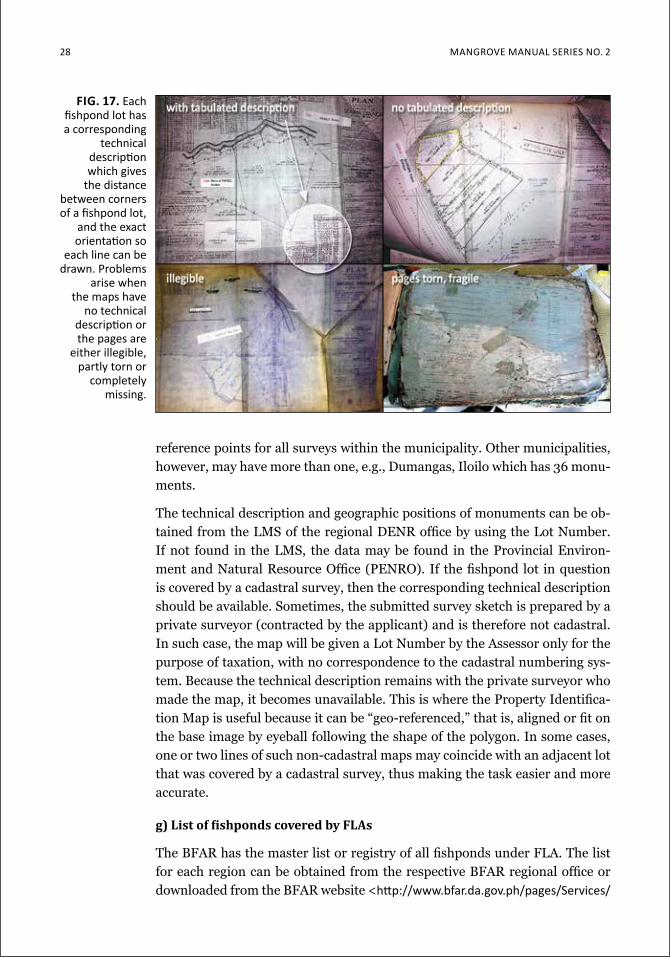
28 Mangrove Manual SerieS no. 2
reference points for all surveys within the municipality. Other municipalities, however, may have more than one, e.g., Dumangas, Iloilo which has 36 monu-ments.
The technical description and geographic positions of monuments can be ob-tained from the LMS of the regional DENR office by using the Lot Number. If not found in the LMS, the data may be found in the Provincial Environ-ment and Natural Resource Office (PENRO). If the fishpond lot in question is covered by a cadastral survey, then the corresponding technical description should be available. Sometimes, the submitted survey sketch is prepared by a private surveyor (contracted by the applicant) and is therefore not cadastral. In such case, the map will be given a Lot Number by the Assessor only for the purpose of taxation, with no correspondence to the cadastral numbering sys-tem. Because the technical description remains with the private surveyor who made the map, it becomes unavailable. This is where the Property Identifica-tion Map is useful because it can be “geo-referenced,” that is, aligned or fit on the base image by eyeball following the shape of the polygon. In some cases, one or two lines of such non-cadastral maps may coincide with an adjacent lot that was covered by a cadastral survey, thus making the task easier and more accurate.
g) list of fishponds covered by Flas
The BFAR has the master list or registry of all fishponds under FLA. The list for each region can be obtained from the respective BFAR regional office or downloaded from the BFAR website <http://www.bfar.da.gov.ph/pages/Services/
fig. 17. each fishpond lot has a corresponding
technical description which gives
the distance between corners of a fishpond lot,
and the exact orientation so
each line can be drawn. Problems
arise when the maps have
no technical description or the pages are
either illegible, partly torn or
completely missing.
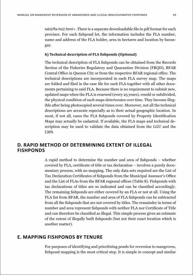
Manual on Mangrove reverSion of aBandoned and illegal BrackiSHwater fiSHPondS 29
tab3/fla-list2.html>. There is a separate downloadable file in pdf format for each province. For each fishpond lot, the information includes the FLA number, name and address of the FLA holder, area in hectares and location by baran-gay.
h) technical description of Fla fishponds (optional)
The technical description of FLA fishponds can be obtained from the Records Section of the Fisheries Regulatory and Quarantine Division (FRQD), BFAR Central Office in Quezon City or from the respective BFAR regional office. The technical descriptions are incorporated in each FLA survey map. The maps are folded and filed in the case file for each FLA together with all other docu-ments pertaining to said FLA. Because there is no requirement to submit new, updated maps when the FLA is renewed (every 25 years), resold or subdivided, the physical condition of such maps deteriorates over time. They become illeg-ible after being photocopied several times over. Moreover, not all the technical descriptions are accurate especially as to their actual geographic location. In most, if not all, cases the FLA fishponds covered by Property Identification Maps may actually be cadastral. If available, the FLA maps and technical de-scription may be used to validate the data obtained from the LGU and the LMS.
d. rapid Method of deterMining extent of illegal fishponds
A rapid method to determine the number and area of fishponds – whether covered by FLA, certificate of title or tax declaration – involves a purely docu-mentary process, with no mapping. The only data sets required are the List of Tax Declaration Certificates of fishponds from the Municipal Assessor’s Office and the List of FLAs from the BFAR regional offices (Table 8). Fishponds with tax declarations of titles are so indicated and can be classified accordingly. The remaining fishponds are either covered by an FLA or not at all. Using the FLA list from BFAR, the number and area of FLA fishponds can be subtracted from all the fishponds that are not covered by titles. The remainder in terms of number and area represent fishponds with neither FLA nor Certificate of Title and can therefore be classified as illegal. This simple process gives an estimate of the extent of illegally built fishponds (but not their exact location which is another matter).
e. Mapping fishponds by tenure
For purposes of identifying and prioritizing ponds for reversion to mangroves, fishpond mapping is the most critical step. It is simple in concept and similar
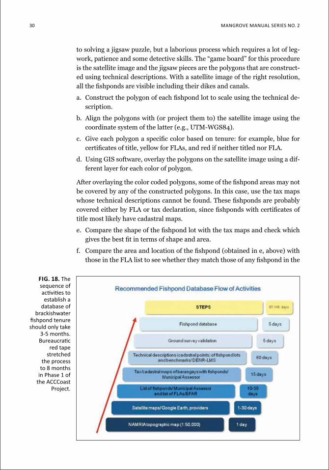
30 Mangrove Manual SerieS no. 2
to solving a jigsaw puzzle, but a laborious process which requires a lot of leg-work, patience and some detective skills. The “game board” for this procedure is the satellite image and the jigsaw pieces are the polygons that are construct-ed using technical descriptions. With a satellite image of the right resolution, all the fishponds are visible including their dikes and canals.
a. Construct the polygon of each fishpond lot to scale using the technical de-scription.
b. Align the polygons with (or project them to) the satellite image using the coordinate system of the latter (e.g., UTM-WGS84).
c. Give each polygon a specific color based on tenure: for example, blue for certificates of title, yellow for FLAs, and red if neither titled nor FLA.
d. Using GIS software, overlay the polygons on the satellite image using a dif-ferent layer for each color of polygon.
After overlaying the color coded polygons, some of the fishpond areas may not be covered by any of the constructed polygons. In this case, use the tax maps whose technical descriptions cannot be found. These fishponds are probably covered either by FLA or tax declaration, since fishponds with certificates of title most likely have cadastral maps.
e. Compare the shape of the fishpond lot with the tax maps and check which gives the best fit in terms of shape and area.
f. Compare the area and location of the fishpond (obtained in e, above) with those in the FLA list to see whether they match those of any fishpond in the
fig. 18. The sequence of activities to establish a
database of brackishwater
fishpond tenure should only take
3-5 months. Bureaucratic
red tape stretched
the process to 8 months
in Phase 1 of the acccoast
Project.
Manual on Mangrove reverSion of aBandoned and illegal BrackiSHwater fiSHPondS 31
list. The BFAR files record area up to the last square meter or four decimal places (e.g., 6.7453 ha) so a unique match may easily be found, unless the area involved is a nice round figure like 5.0000 ha.
g. Construct a polygon with the appropriate color using the tax map as guide, and fit over the “unfilled” fishpond in the satellite image.
The sequence of required activities to reach the mapping stage is summarized in a flow chart in Fig. 18. The end product of such activities is a map showing all the brackishwater ponds in a given municipality color-coded according to tenure – mostly covered by tax declarations (66.4%: Fig. 19) in Ibajay, Aklan, in contrast to Panay, Capiz where ponds are mostly titled in strikingly uniform parcels of 5 ha and 12 ha sizes (63.9%: Fig. 20). Titling of such parcels is ap-proved at the PENRO and DENR regional level, respectively. Appendices 7A-E show the tenurial pond maps for the remaining 5 municipalities – Leganes, Dumangas and Ajuy in Iloilo, Nueva Valencia in Guimaras, and Ivisan in Capiz.
f. expected probleMs
As with any undertaking, overlaying fishpond lots on a satellite image has its own problems as described in earlier sections. They are summed up here for easy reference to possible actions to take if encountered:
a. The government officer involved (LGU Assessor; LMS, CENRO or PENRO at the DENR regional office) is less than cooperative and does not entertain your request.
Action: Most offices readily entertain requests for information and data but do not want to be rushed while doing it. Prior to the actual visit, it will help if a formal letter request is sent to the office/officer concerned explaining the purpose of the data being collected. As requesting party, one has to be always courteous, friendly and patient. Remember that while the data you request are the most important thing in your list of requirements, the of-fice being requested may also have its own work load and priorities. If not immediately available, it is best to ask the staff concerned when you can return for the needed data.
b. The municipality has not compiled a master list of taxable properties that are classified according to land use, based on the tax declaration certifi-cates.
Action: The only solution to such problem is to compile your own list of fishponds using the tax declaration files. This could run to thousands of ponds in an average municipality. Again be courteous, friendly and patient so you will be given access to the tax declaration records.
c. The municipal records are old, brittle and portions are not legible or com-pletely missing.
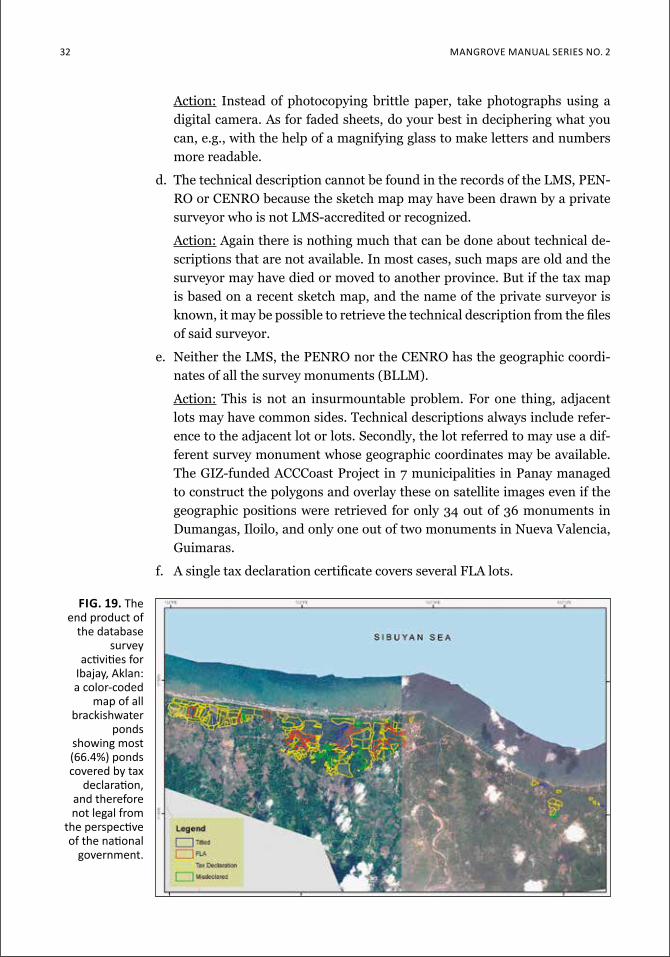
32 Mangrove Manual SerieS no. 2
Action: Instead of photocopying brittle paper, take photographs using a digital camera. As for faded sheets, do your best in deciphering what you can, e.g., with the help of a magnifying glass to make letters and numbers more readable.
d. The technical description cannot be found in the records of the LMS, PEN-RO or CENRO because the sketch map may have been drawn by a private surveyor who is not LMS-accredited or recognized.
Action: Again there is nothing much that can be done about technical de-scriptions that are not available. In most cases, such maps are old and the surveyor may have died or moved to another province. But if the tax map is based on a recent sketch map, and the name of the private surveyor is known, it may be possible to retrieve the technical description from the files of said surveyor.
e. Neither the LMS, the PENRO nor the CENRO has the geographic coordi-nates of all the survey monuments (BLLM).
Action: This is not an insurmountable problem. For one thing, adjacent lots may have common sides. Technical descriptions always include refer-ence to the adjacent lot or lots. Secondly, the lot referred to may use a dif-ferent survey monument whose geographic coordinates may be available. The GIZ-funded ACCCoast Project in 7 municipalities in Panay managed to construct the polygons and overlay these on satellite images even if the geographic positions were retrieved for only 34 out of 36 monuments in Dumangas, Iloilo, and only one out of two monuments in Nueva Valencia, Guimaras.
f. A single tax declaration certificate covers several FLA lots.
Fig. 19. The end product of
the database survey
activities for ibajay, aklan: a color-coded
map of all brackishwater
ponds showing most (66.4%) ponds covered by tax
declaration, and therefore not legal from
the perspective of the national
government.
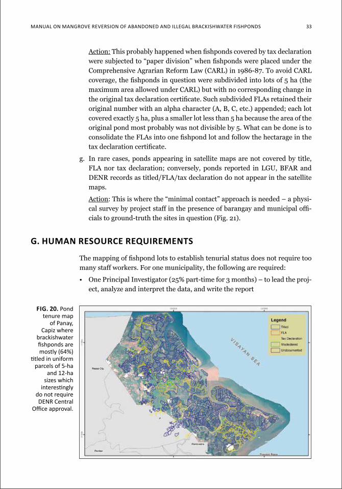
Manual on Mangrove reverSion of aBandoned and illegal BrackiSHwater fiSHPondS 33
Fig. 20. pond tenure map
of Panay, capiz where
brackishwater fishponds are mostly (64%)
titled in uniform parcels of 5-ha
and 12-ha sizes which
interestingly do not require denr central
office approval.
Action: This probably happened when fishponds covered by tax declaration were subjected to “paper division” when fishponds were placed under the Comprehensive Agrarian Reform Law (CARL) in 1986-87. To avoid CARL coverage, the fishponds in question were subdivided into lots of 5 ha (the maximum area allowed under CARL) but with no corresponding change in the original tax declaration certificate. Such subdivided FLAs retained their original number with an alpha character (A, B, C, etc.) appended; each lot covered exactly 5 ha, plus a smaller lot less than 5 ha because the area of the original pond most probably was not divisible by 5. What can be done is to consolidate the FLAs into one fishpond lot and follow the hectarage in the tax declaration certificate.
g. In rare cases, ponds appearing in satellite maps are not covered by title, FLA nor tax declaration; conversely, ponds reported in LGU, BFAR and DENR records as titled/FLA/tax declaration do not appear in the satellite maps.
Action: This is where the “minimal contact” approach is needed – a physi-cal survey by project staff in the presence of barangay and municipal offi-cials to ground-truth the sites in question (Fig. 21).
g. huMan resource requireMents
The mapping of fishpond lots to establish tenurial status does not require too many staff workers. For one municipality, the following are required:
• One Principal Investigator (25% part-time for 3 months) – to lead the proj-ect, analyze and interpret the data, and write the report
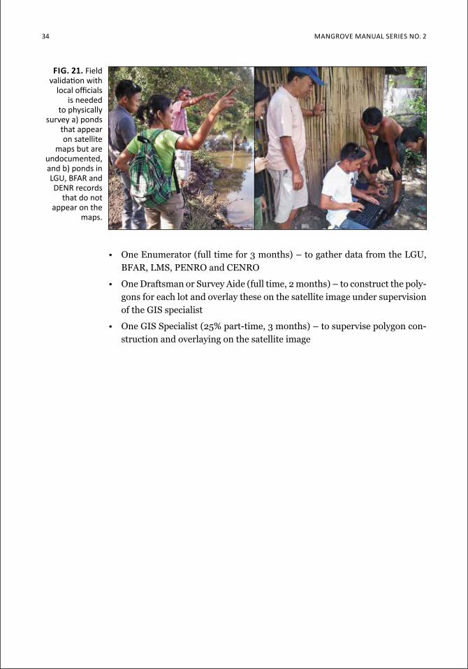
34 Mangrove Manual SerieS no. 2
• One Enumerator (full time for 3 months) – to gather data from the LGU, BFAR, LMS, PENRO and CENRO
• One Draftsman or Survey Aide (full time, 2 months) – to construct the poly-gons for each lot and overlay these on the satellite image under supervision of the GIS specialist
• One GIS Specialist (25% part-time, 3 months) – to supervise polygon con-struction and overlaying on the satellite image
Fig. 21. field validation with
local officials is needed
to physically survey a) ponds
that appear on satellite
maps but are undocumented, and b) ponds in lgu, Bfar and denr records
that do not appear on the
maps.
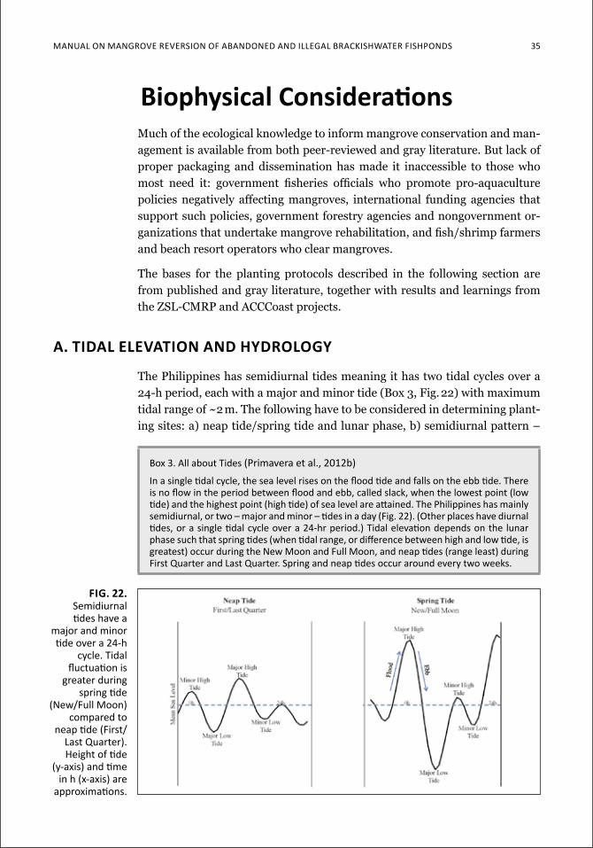
Manual on Mangrove reverSion of aBandoned and illegal BrackiSHwater fiSHPondS 35
biophysical ConsiderationsMuch of the ecological knowledge to inform mangrove conservation and man-agement is available from both peer-reviewed and gray literature. But lack of proper packaging and dissemination has made it inaccessible to those who most need it: government fisheries officials who promote pro-aquaculture policies negatively affecting mangroves, international funding agencies that support such policies, government forestry agencies and nongovernment or-ganizations that undertake mangrove rehabilitation, and fish/shrimp farmers and beach resort operators who clear mangroves.
The bases for the planting protocols described in the following section are from published and gray literature, together with results and learnings from the ZSL-CMRP and ACCCoast projects.
a. tidal elevation and hydrology
The Philippines has semidiurnal tides meaning it has two tidal cycles over a 24-h period, each with a major and minor tide (Box 3, Fig. 22) with maximum tidal range of ~2 m. The following have to be considered in determining plant-ing sites: a) neap tide/spring tide and lunar phase, b) semidiurnal pattern –
Box 3. all about tides (Primavera et al., 2012b)in a single tidal cycle, the sea level rises on the flood tide and falls on the ebb tide. there is no flow in the period between flood and ebb, called slack, when the lowest point (low tide) and the highest point (high tide) of sea level are attained. the Philippines has mainly semidiurnal, or two – major and minor – tides in a day (fig. 22). (other places have diurnal tides, or a single tidal cycle over a 24-hr period.) tidal elevation depends on the lunar phase such that spring tides (when tidal range, or difference between high and low tide, is greatest) occur during the new Moon and full Moon, and neap tides (range least) during first Quarter and last Quarter. Spring and neap tides occur around every two weeks.
Fig. 22. Semidiurnal tides have a
major and minor tide over a 24-h
cycle. tidal fluctuation is
greater during spring tide
(new/full Moon) compared to
neap tide (first/last Quarter). Height of tide
(y-axis) and time in h (x-axis) are
approximations.
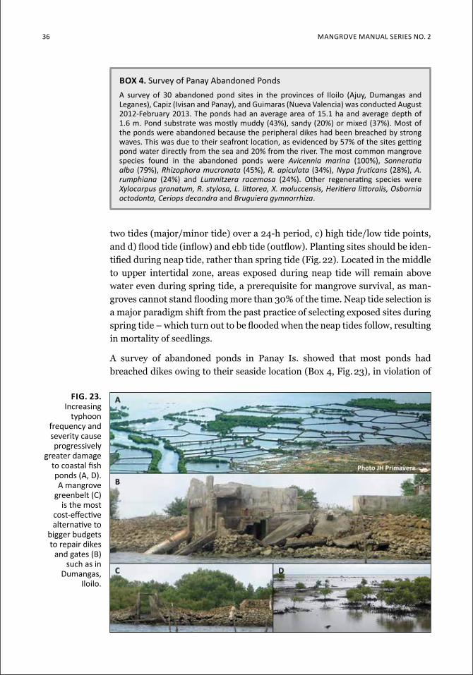
36 Mangrove Manual SerieS no. 2
two tides (major/minor tide) over a 24-h period, c) high tide/low tide points, and d) flood tide (inflow) and ebb tide (outflow). Planting sites should be iden-tified during neap tide, rather than spring tide (Fig. 22). Located in the middle to upper intertidal zone, areas exposed during neap tide will remain above water even during spring tide, a prerequisite for mangrove survival, as man-groves cannot stand flooding more than 30% of the time. Neap tide selection is a major paradigm shift from the past practice of selecting exposed sites during spring tide – which turn out to be flooded when the neap tides follow, resulting in mortality of seedlings.
A survey of abandoned ponds in Panay Is. showed that most ponds had breached dikes owing to their seaside location (Box 4, Fig. 23), in violation of
box 4. Survey of Panay abandoned Pondsa survey of 30 abandoned pond sites in the provinces of iloilo (ajuy, dumangas and leganes), capiz (ivisan and Panay), and guimaras (nueva valencia) was conducted august 2012-february 2013. the ponds had an average area of 15.1 ha and average depth of 1.6 m. Pond substrate was mostly muddy (43%), sandy (20%) or mixed (37%). Most of the ponds were abandoned because the peripheral dikes had been breached by strong waves. this was due to their seafront location, as evidenced by 57% of the sites getting pond water directly from the sea and 20% from the river. the most common mangrove species found in the abandoned ponds were Avicennia marina (100%), Sonneratiaalba (79%), Rhizophora mucronata (45%), R. apiculata (34%), Nypafruticans (28%), A. rumphiana (24%) and Lumnitzera racemosa (24%). other regenerating species were Xylocarpusgranatum,R.stylosa,L.littorea,X.moluccensis,Heritieralittoralis,Osborniaoctodonta, Ceriops decandra and Bruguiera gymnorrhiza.
Fig. 23. increasing
typhoon frequency and severity cause progressively
greater damage to coastal fish ponds (a, d). a mangrove
greenbelt (c) is the most
cost-effective alternative to
bigger budgets to repair dikes
and gates (B) such as in
dumangas, iloilo.
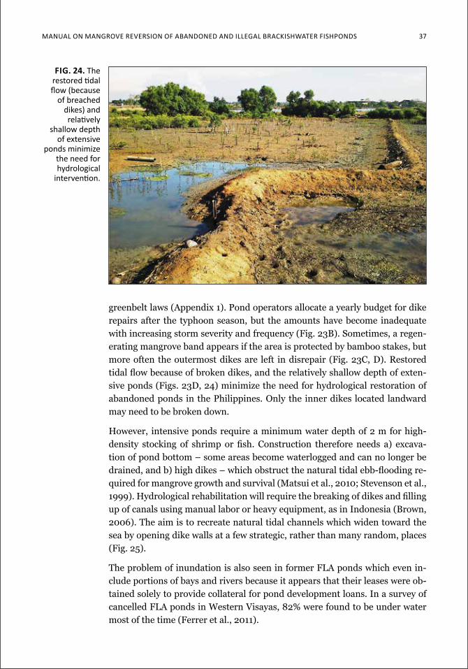
Manual on Mangrove reverSion of aBandoned and illegal BrackiSHwater fiSHPondS 37
greenbelt laws (Appendix 1). Pond operators allocate a yearly budget for dike repairs after the typhoon season, but the amounts have become inadequate with increasing storm severity and frequency (Fig. 23B). Sometimes, a regen-erating mangrove band appears if the area is protected by bamboo stakes, but more often the outermost dikes are left in disrepair (Fig. 23C, D). Restored tidal flow because of broken dikes, and the relatively shallow depth of exten-sive ponds (Figs. 23D, 24) minimize the need for hydrological restoration of abandoned ponds in the Philippines. Only the inner dikes located landward may need to be broken down.
However, intensive ponds require a minimum water depth of 2 m for high-density stocking of shrimp or fish. Construction therefore needs a) excava-tion of pond bottom – some areas become waterlogged and can no longer be drained, and b) high dikes – which obstruct the natural tidal ebb-flooding re-quired for mangrove growth and survival (Matsui et al., 2010; Stevenson et al., 1999). Hydrological rehabilitation will require the breaking of dikes and filling up of canals using manual labor or heavy equipment, as in Indonesia (Brown, 2006). The aim is to recreate natural tidal channels which widen toward the sea by opening dike walls at a few strategic, rather than many random, places (Fig. 25).
The problem of inundation is also seen in former FLA ponds which even in-clude portions of bays and rivers because it appears that their leases were ob-tained solely to provide collateral for pond development loans. In a survey of cancelled FLA ponds in Western Visayas, 82% were found to be under water most of the time (Ferrer et al., 2011).
Fig. 24. The restored tidal flow (because
of breached dikes) and relatively
shallow depth of extensive
ponds minimize the need for hydrological
intervention.
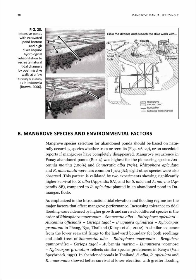
38 Mangrove Manual SerieS no. 2
b. Mangrove species and environMental factors
Mangrove species selection for abandoned ponds should be based on natu-rally occurring species whether trees or recruits (Figs. 26, 27), or on anecdotal reports if mangroves have completely disappeared. Mangrove occurrence in Panay abandoned ponds (Box 4) was highest for the pioneering species Avi-cennia marina (100%) and Sonneratia alba (79%). Rhizophora apiculata and R. mucronata were less common (34-45%); eight other species were also observed. This pattern is validated by two experiments showing significantly higher survival for S. alba (Appendix 8A), and for S. alba and A. marina (Ap-pendix 8B), compared to R. apiculata planted in an abandoned pond in Du-mangas, Iloilo.
As emphasized in the Introduction, tidal elevation and flooding regime are the major factors that affect mangrove performance. Increasing tolerance to tidal flooding was evidenced by higher growth and survival of different species in the order of Rhizophora mucronata – Sonneratia alba – Rhizophora apiculata – Avicennia officinalis – Ceriops tagal – Bruguiera cylindrica – Xylocarpus granatum in Phang, Nga, Thailand (Kitaya et al., 2002). A similar sequence from the lower seaward fringe to the landward boundary for both seedlings and adult trees of Sonneratia alba – Rhizophora mucronata – Bruguiera gymnorrhiza – Ceriops tagal – Avicennia marina – Lumnitzera racemosa – Xylocarpus granatum reflects similar species preferences in Kenya (Van Speybroeck, 1992). In abandoned ponds in Thailand, S. alba, R. apiculata and R. mucronata showed better survival at lower elevation with greater flooding
Fig. 25. intensive ponds with excavated
pond bottom and high
dikes require hydrological
rehabilitation to recreate natural
tidal channels by opening dike
walls at a few strategic places, as in indonesia (Brown, 2006).
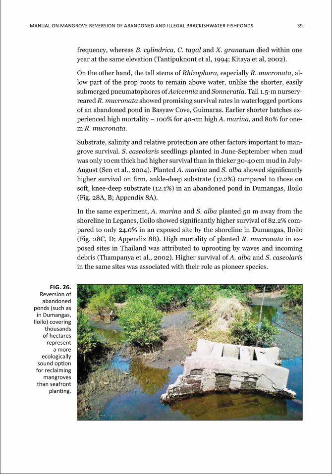
Manual on Mangrove reverSion of aBandoned and illegal BrackiSHwater fiSHPondS 39
frequency, whereas B. cylindrica, C. tagal and X. granatum died within one year at the same elevation (Tantipuknont et al, 1994; Kitaya et al, 2002).
On the other hand, the tall stems of Rhizophora, especially R. mucronata, al-low part of the prop roots to remain above water, unlike the shorter, easily submerged pneumatophores of Avicennia and Sonneratia. Tall 1.5-m nursery-reared R. mucronata showed promising survival rates in waterlogged portions of an abandoned pond in Basyaw Cove, Guimaras. Earlier shorter batches ex-perienced high mortality – 100% for 40-cm high A. marina, and 80% for one-m R. mucronata.
Substrate, salinity and relative protection are other factors important to man-grove survival. S. caseolaris seedlings planted in June-September when mud was only 10 cm thick had higher survival than in thicker 30-40 cm mud in July-August (Sen et al., 2004). Planted A. marina and S. alba showed significantly higher survival on firm, ankle-deep substrate (17.2%) compared to those on soft, knee-deep substrate (12.1%) in an abandoned pond in Dumangas, Iloilo (Fig. 28A, B; Appendix 8A).
In the same experiment, A. marina and S. alba planted 50 m away from the shoreline in Leganes, Iloilo showed significantly higher survival of 82.2% com-pared to only 24.0% in an exposed site by the shoreline in Dumangas, Iloilo (Fig. 28C, D; Appendix 8B). High mortality of planted R. mucronata in ex-posed sites in Thailand was attributed to uprooting by waves and incoming debris (Thampanya et al., 2002). Higher survival of A. alba and S. caseolaris in the same sites was associated with their role as pioneer species.
Fig. 26. reversion of abandoned
ponds (such as in dumangas,
iloilo) covering thousands
of hectares represent
a more ecologically
sound option for reclaiming
mangroves than seafront
planting.
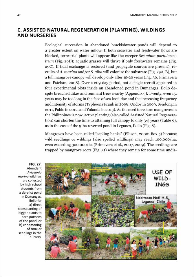
40 Mangrove Manual SerieS no. 2
C. aSSiSTed naTural regeneraTion (PlanTing), WildingS and nurseries
Ecological succession in abandoned brackishwater ponds will depend to a greater extent on water inflow. If both seawater and freshwater flows are blocked, terrestrial plants will appear like the creeper Sesuvium portulacas-trum (Fig. 29D); aquatic grasses will thrive if only freshwater remains (Fig. 29C). If tidal exchange is restored (and propagule sources are present), re-cruits of A. marina and/or S. alba will colonize the substrate (Fig. 29A, B), but a full mangrove canopy will develop only after 15-20 years (Fig. 30; Primavera and Esteban, 2008). Over a 209-day period, not a single recruit appeared in four experimental plots inside an abandoned pond in Dumangas, Iloilo de-spite breached dikes and remnant trees nearby (Appendix 9). Twenty, even 15, years may be too long in the face of sea level rise and the increasing frequency and intensity of storms (Typhoons Frank in 2008, Ondoy in 2009, Sendong in 2011, Pablo in 2012, and Yolanda in 2013). As the need to restore mangroves in the Philippines is now, active planting (also called Assisted Natural Regenera-tion) can shorten the time to attaining full canopy to only 3-5 years (Table 9), as in the case of the 9-ha reverted pond in Leganes, Iloilo (Fig. 8).
Mangroves have been called “sapling banks” (Ellison, 2000: Box 5) because wild seedlings or wildings (also spelled wildlings) may reach 100,000/ha, even exceeding 300,000/ha (Primavera et al., 2007, 2009). The seedlings are trapped by mangrove roots (Fig. 31) where they remain for some time undis-
Fig. 27. abundant Avicennia
marina wildings are collected
by high school students from
a derelict pond in dumangas,
iloilo for a) direct
transplanting of bigger plants to
bare portions of the pond, or b) conditioning
of smaller seedlings in the
nursery.
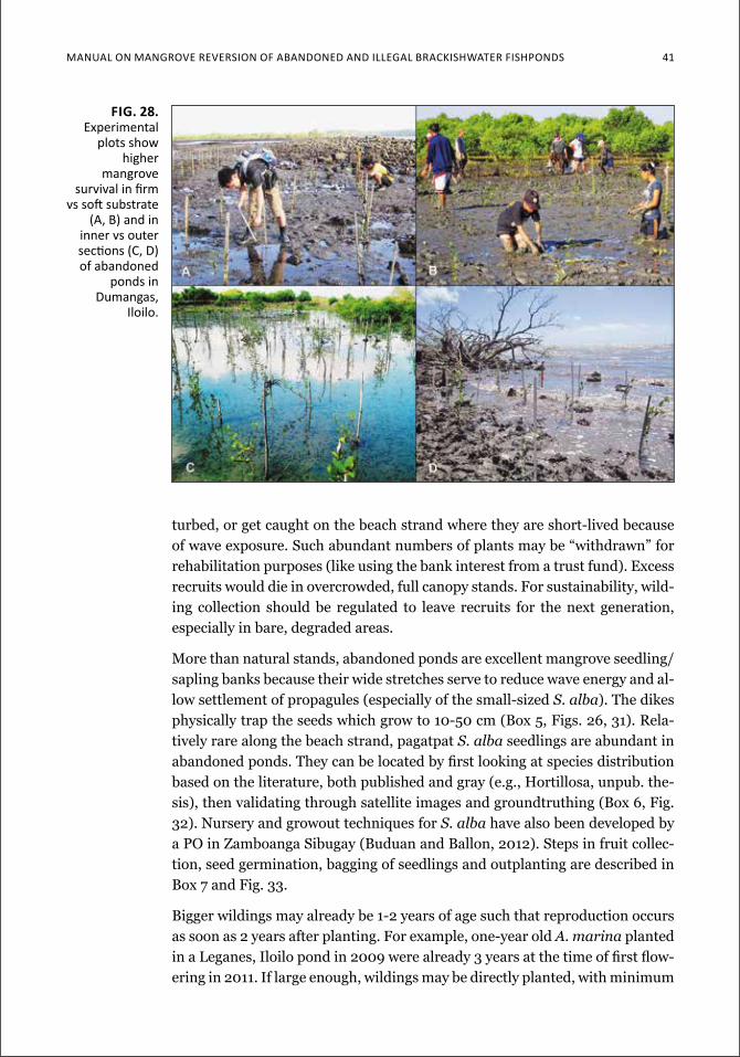
Manual on Mangrove reverSion of aBandoned and illegal BrackiSHwater fiSHPondS 41
turbed, or get caught on the beach strand where they are short-lived because of wave exposure. Such abundant numbers of plants may be “withdrawn” for rehabilitation purposes (like using the bank interest from a trust fund). Excess recruits would die in overcrowded, full canopy stands. For sustainability, wild-ing collection should be regulated to leave recruits for the next generation, especially in bare, degraded areas.
More than natural stands, abandoned ponds are excellent mangrove seedling/sapling banks because their wide stretches serve to reduce wave energy and al-low settlement of propagules (especially of the small-sized S. alba). The dikes physically trap the seeds which grow to 10-50 cm (Box 5, Figs. 26, 31). Rela-tively rare along the beach strand, pagatpat S. alba seedlings are abundant in abandoned ponds. They can be located by first looking at species distribution based on the literature, both published and gray (e.g., Hortillosa, unpub. the-sis), then validating through satellite images and groundtruthing (Box 6, Fig. 32). Nursery and growout techniques for S. alba have also been developed by a PO in Zamboanga Sibugay (Buduan and Ballon, 2012). Steps in fruit collec-tion, seed germination, bagging of seedlings and outplanting are described in Box 7 and Fig. 33.
Bigger wildings may already be 1-2 years of age such that reproduction occurs as soon as 2 years after planting. For example, one-year old A. marina planted in a Leganes, Iloilo pond in 2009 were already 3 years at the time of first flow-ering in 2011. If large enough, wildings may be directly planted, with minimum
Fig. 28. experimental
plots show higher
mangrove survival in firm
vs soft substrate (a, B) and in
inner vs outer sections (c, d) of abandoned
ponds in dumangas,
iloilo.
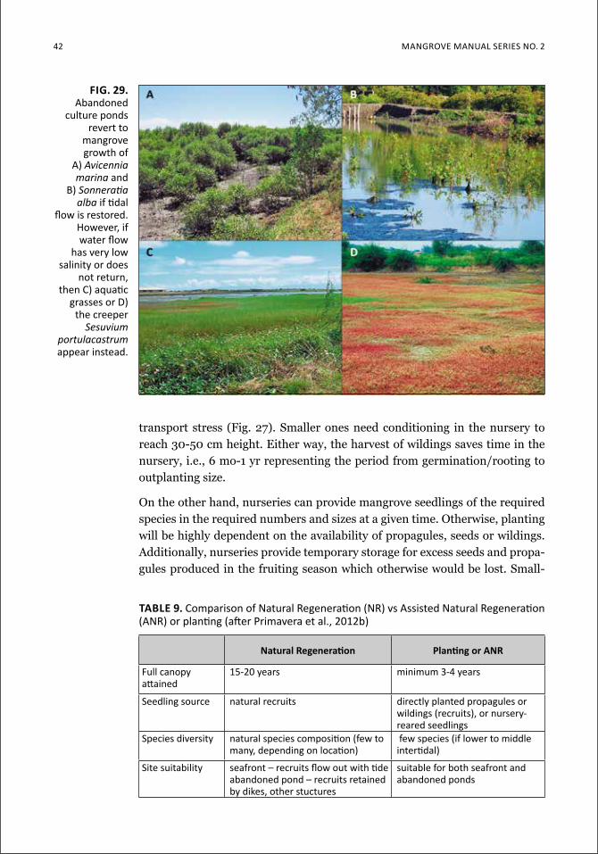
42 Mangrove Manual SerieS no. 2
transport stress (Fig. 27). Smaller ones need conditioning in the nursery to reach 30-50 cm height. Either way, the harvest of wildings saves time in the nursery, i.e., 6 mo-1 yr representing the period from germination/rooting to outplanting size.
On the other hand, nurseries can provide mangrove seedlings of the required species in the required numbers and sizes at a given time. Otherwise, planting will be highly dependent on the availability of propagules, seeds or wildings. Additionally, nurseries provide temporary storage for excess seeds and propa-gules produced in the fruiting season which otherwise would be lost. Small-
Fig. 29. abandoned
culture ponds revert to
mangrove growth of
a) Avicennia marina and
B) Sonneratiaalba if tidal
flow is restored. However, if water flow
has very low salinity or does
not return, then c) aquatic
grasses or d) the creeper
Sesuvium portulacastrum appear instead.
Table 9. comparison of natural regeneration (nr) vs assisted natural regeneration (anr) or planting (after Primavera et al., 2012b)
natural regeneration Planting or anr
full canopy attained
15-20 years minimum 3-4 years
Seedling source natural recruits directly planted propagules or wildings (recruits), or nursery-reared seedlings
Species diversity natural species composition (few to many, depending on location)
few species (if lower to middle intertidal)
Site suitability seafront – recruits flow out with tideabandoned pond – recruits retained by dikes, other stuctures
suitable for both seafront and abandoned ponds
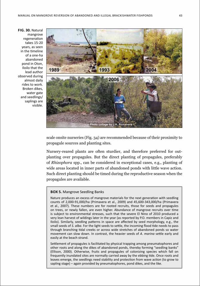
Manual on Mangrove reverSion of aBandoned and illegal BrackiSHwater fiSHPondS 43
Fig. 30. natural mangrove
regeneration takes 15-20
years, as seen in the timeline
of a one-ha abandoned
pond in oton, iloilo that the
lead author observed during
almost daily rides to work. Broken dikes,
water gate and seedlings/
saplings are visible.
scale onsite nurseries (Fig. 34) are recommended because of their proximity to propagule sources and planting sites.
Nursery-reared plants are often sturdier, and therefore preferred for out-planting over propagules. But the direct planting of propagules, preferably of Rhizophora spp., can be considered in exceptional cases, e.g., planting of wide areas located in inner parts of abandoned ponds with little wave action. Such direct planting should be timed during the reproductive season when the propagules are available.
box 5. Mangrove Seedling banksnature produces an excess of mangrove materials for the next generation with seedling counts of 2,000-91,000/ha (Primavera et al., 2009) and 45,600-343,000/ha (Primavera et al., 2007). these numbers are for rooted recruits, those for seeds and propagules on trees, or newly fallen, are even higher. abundance of mangrove recruits over time is subject to environmental stresses, such that the severe el nino of 2010 produced a very lean harvest of wildings later in the year (as reported by P.o. members in capiz and iloilo). Similarly, seedling patterns in space are affected by seed morphology, e.g., the small seeds of S. alba. for the light seeds to settle, the incoming flood tide needs to pass through branching tidal creeks or across wide stretches of abandoned ponds so water movement can slow down. in contrast, the heavier seeds of A. marina settle early and easily at the beach strand.
Settlement of propagules is facilitated by physical trapping among pneumatophores and other roots and along the dikes of abandoned ponds, thereby forming “seedling banks” (ellison, 2000). otherwise, fruits and propagules of colonizing species which fall on frequently inundated sites are normally carried away by the ebbing tide. once roots and leaves emerge, the seedlings need stability and protection from wave action (to grow to sapling stage) – again provided by pneumatophores, pond dikes, and the like.
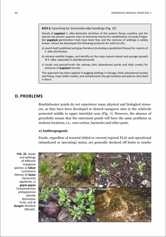
44 Mangrove Manual SerieS no. 2
d. probleMs
Brackishwater ponds do not experience many physical and biological stress-ors, as they have been developed in cleared mangrove sites in the relatively protected middle to upper intertidal zone (Fig. 7). However, the absence of greenbelts means that the outermost ponds will have the same problems as seafront locations, i.e., wave action, barnacles and other pests.
1) Anthropogenic
Ponds, regardless of tenurial (titled or current/expired FLA) and operational (abandoned or operating) status, are generally declared off limits to nearby
box 6. Searching for Sonneratiaalba Seedlings (fig. 32)Stands of pagatpat S. alba dominate stretches of the eastern Panay coastline and the species has proven superior even to Avicennia marina for rehabilitation of sandy fringes. but pagatpat germination trials have been few, and the rareness of wildings is widely known. Hence we developed the following protocols for wild recruits:
a) search both published and gray literature (including unpublished theses) for reports of S. alba distribution
b) retrieve satellite images, and identify on the maps mature stands and younger growth of S. alba, especially in abandoned ponds
c) locate and ground-truth the satmap sites (abandoned ponds and tidal creeks) for presence of pagatpat recruits
This approach has been applied in bagging wildings in Zarraga, iloilo (abandoned ponds) and Panay, capiz (tidal creeks), and complements the germination procedures described in Box 6.
fig. 31. Seeds and wildings
of different mangrove
species: a) tabao Lumnitzera
littorea, b) lipata Excoecaria
agallocha, c) gapas-gapas
Camptostemon philippinensis
(beside Xylocarpus
fruit), and d) dungon Heritiera
littoralis.
photos by J.h. primavera
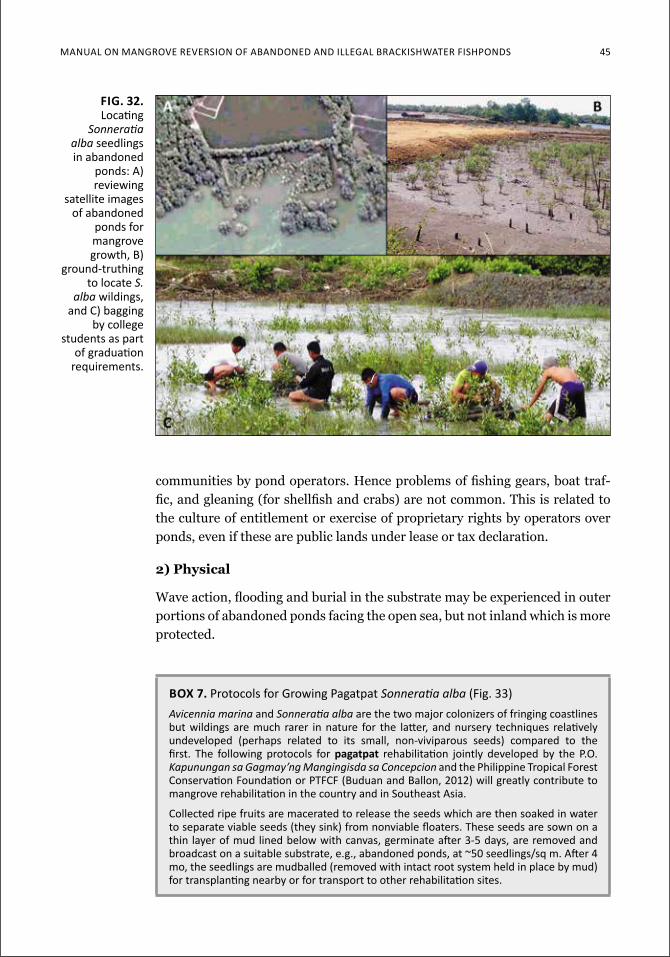
Manual on Mangrove reverSion of aBandoned and illegal BrackiSHwater fiSHPondS 45
communities by pond operators. Hence problems of fishing gears, boat traf-fic, and gleaning (for shellfish and crabs) are not common. This is related to the culture of entitlement or exercise of proprietary rights by operators over ponds, even if these are public lands under lease or tax declaration.
2) physical
Wave action, flooding and burial in the substrate may be experienced in outer portions of abandoned ponds facing the open sea, but not inland which is more protected.
Fig. 32. locating
Sonneratiaalba seedlings in abandoned
ponds: a) reviewing
satellite images of abandoned
ponds for mangrove growth, B)
ground-truthing to locate S.
alba wildings, and c) bagging
by college students as part
of graduation requirements.
box 7. Protocols for growing Pagatpat Sonneratiaalba(fig. 33)Avicennia marina andSonneratiaalba are the two major colonizers of fringing coastlines but wildings are much rarer in nature for the latter, and nursery techniques relatively undeveloped (perhaps related to its small, non-viviparous seeds) compared to the first. the following protocols for pagatpat rehabilitation jointly developed by the P.o. Kapunungan sa Gagmay’ng Mangingisda sa Concepcion and the philippine Tropical forest conservation foundation or Ptfcf (Buduan and Ballon, 2012) will greatly contribute to mangrove rehabilitation in the country and in Southeast asia.
collected ripe fruits are macerated to release the seeds which are then soaked in water to separate viable seeds (they sink) from nonviable floaters. these seeds are sown on a thin layer of mud lined below with canvas, germinate after 3-5 days, are removed and broadcast on a suitable substrate, e.g., abandoned ponds, at ~50 seedlings/sq m. after 4 mo, the seedlings are mudballed (removed with intact root system held in place by mud) for transplanting nearby or for transport to other rehabilitation sites.
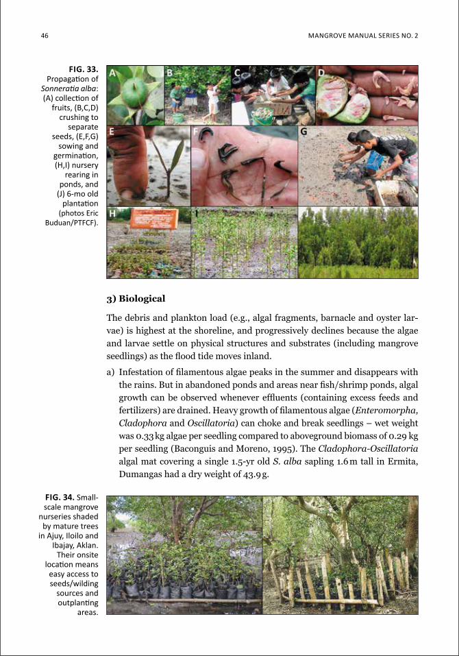
46 Mangrove Manual SerieS no. 2
3) biological
The debris and plankton load (e.g., algal fragments, barnacle and oyster lar-vae) is highest at the shoreline, and progressively declines because the algae and larvae settle on physical structures and substrates (including mangrove seedlings) as the flood tide moves inland.
a) Infestation of filamentous algae peaks in the summer and disappears with the rains. But in abandoned ponds and areas near fish/shrimp ponds, algal growth can be observed whenever effluents (containing excess feeds and fertilizers) are drained. Heavy growth of filamentous algae (Enteromorpha, Cladophora and Oscillatoria) can choke and break seedlings – wet weight was 0.33 kg algae per seedling compared to aboveground biomass of 0.29 kg per seedling (Baconguis and Moreno, 1995). The Cladophora-Oscillatoria algal mat covering a single 1.5-yr old S. alba sapling 1.6 m tall in Ermita, Dumangas had a dry weight of 43.9 g.
fig. 34. Small-scale mangrove
nurseries shaded by mature trees
in ajuy, iloilo and ibajay, aklan.
Their onsite location means
easy access to seeds/wilding
sources and outplanting
areas.
fig. 33. Propagation of
Sonneratiaalba: (a) collection of
fruits, (B,c,d) crushing to
separate seeds, (e,f,g)
sowing and germination, (H,i) nursery
rearing in ponds, and
(J) 6-mo old plantation
(photos eric Buduan/Ptfcf).
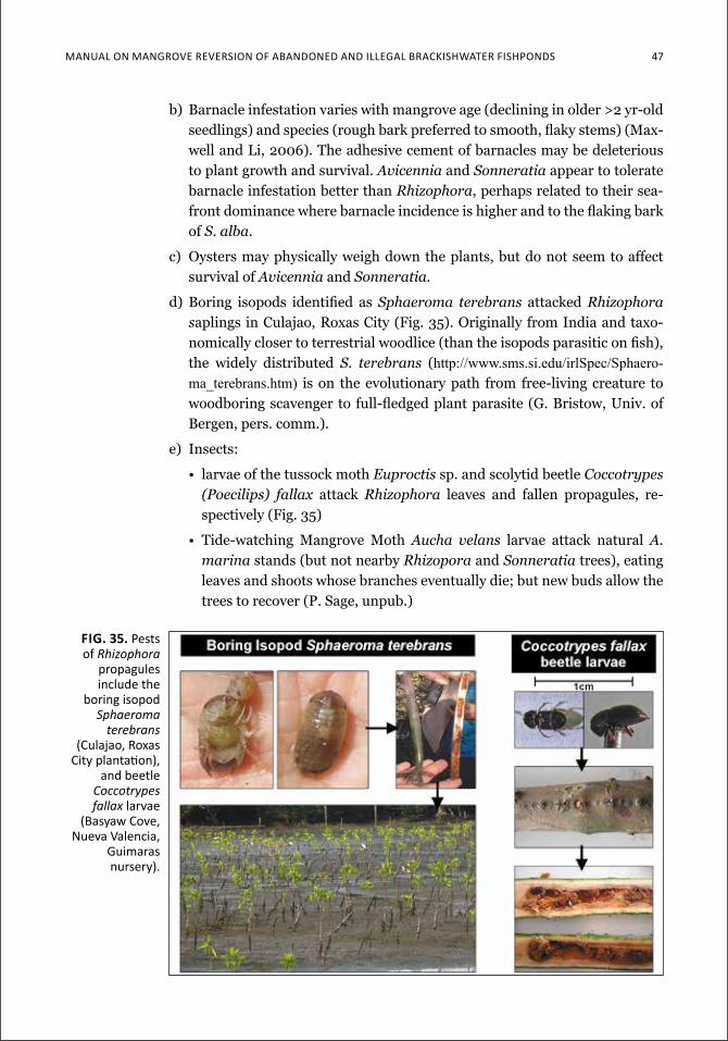
Manual on Mangrove reverSion of aBandoned and illegal BrackiSHwater fiSHPondS 47
b) Barnacle infestation varies with mangrove age (declining in older >2 yr-old seedlings) and species (rough bark preferred to smooth, flaky stems) (Max-well and Li, 2006). The adhesive cement of barnacles may be deleterious to plant growth and survival. Avicennia and Sonneratia appear to tolerate barnacle infestation better than Rhizophora, perhaps related to their sea-front dominance where barnacle incidence is higher and to the flaking bark of S. alba.
c) Oysters may physically weigh down the plants, but do not seem to affect survival of Avicennia and Sonneratia.
d) Boring isopods identified as Sphaeroma terebrans attacked Rhizophora saplings in Culajao, Roxas City (Fig. 35). Originally from India and taxo-nomically closer to terrestrial woodlice (than the isopods parasitic on fish), the widely distributed S. terebrans (http://www.sms.si.edu/irlSpec/Sphaero-ma_terebrans.htm) is on the evolutionary path from free-living creature to woodboring scavenger to full-fledged plant parasite (G. Bristow, Univ. of Bergen, pers. comm.).
e) Insects:
• larvae of the tussock moth Euproctis sp. and scolytid beetle Coccotrypes (Poecilips) fallax attack Rhizophora leaves and fallen propagules, re-spectively (Fig. 35)
• Tide-watching Mangrove Moth Aucha velans larvae attack natural A. marina stands (but not nearby Rhizopora and Sonneratia trees), eating leaves and shoots whose branches eventually die; but new buds allow the trees to recover (P. Sage, unpub.)
fig. 35. pests of Rhizophora
propagules include the
boring isopod Sphaeroma
terebrans (culajao, roxas
city plantation), and beetle
Coccotrypes fallax larvae
(Basyaw cove, nueva valencia,
guimaras nursery).
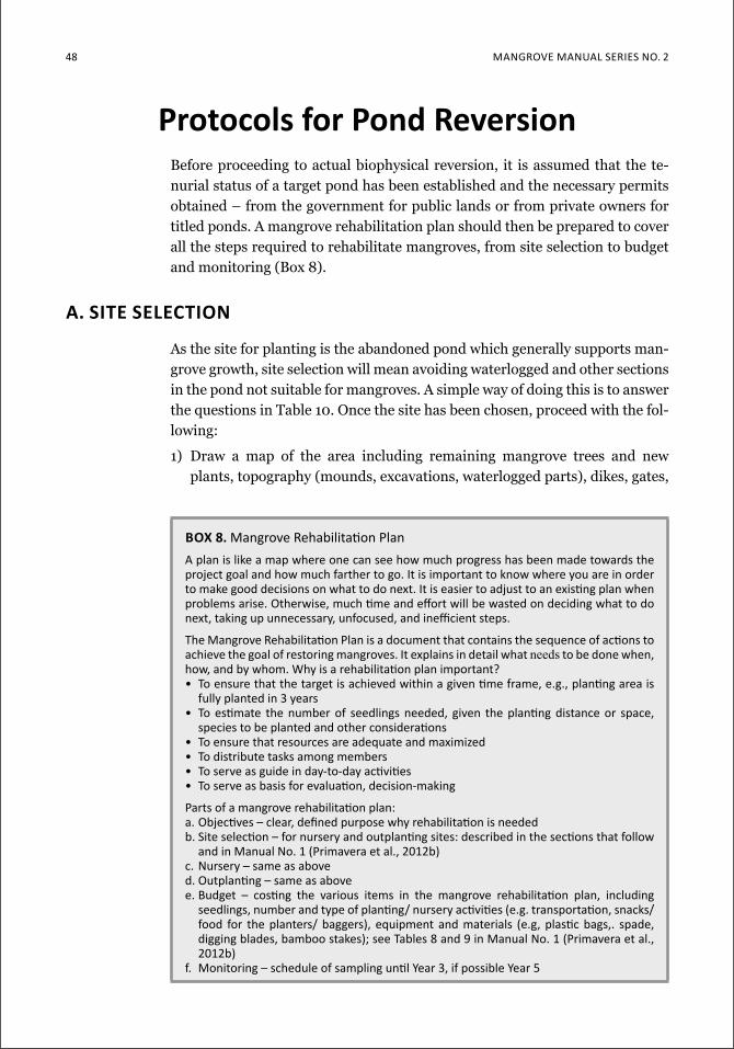
48 Mangrove Manual SerieS no. 2
protocols for pond reversionBefore proceeding to actual biophysical reversion, it is assumed that the te-nurial status of a target pond has been established and the necessary permits obtained – from the government for public lands or from private owners for titled ponds. A mangrove rehabilitation plan should then be prepared to cover all the steps required to rehabilitate mangroves, from site selection to budget and monitoring (Box 8).
a. site selection
As the site for planting is the abandoned pond which generally supports man-grove growth, site selection will mean avoiding waterlogged and other sections in the pond not suitable for mangroves. A simple way of doing this is to answer the questions in Table 10. Once the site has been chosen, proceed with the fol-lowing:
1) Draw a map of the area including remaining mangrove trees and new plants, topography (mounds, excavations, waterlogged parts), dikes, gates,
box 8. Mangrove rehabilitation Plana plan is like a map where one can see how much progress has been made towards the project goal and how much farther to go. it is important to know where you are in order to make good decisions on what to do next. it is easier to adjust to an existing plan when problems arise. otherwise, much time and effort will be wasted on deciding what to do next, taking up unnecessary, unfocused, and inefficient steps.
the Mangrove rehabilitation Plan is a document that contains the sequence of actions to achieve the goal of restoring mangroves. it explains in detail what needs to be done when, how, and by whom. why is a rehabilitation plan important?• to ensure that the target is achieved within a given time frame, e.g., planting area is
fully planted in 3 years• to estimate the number of seedlings needed, given the planting distance or space,
species to be planted and other considerations• To ensure that resources are adequate and maximized• To distribute tasks among members• to serve as guide in day-to-day activities• to serve as basis for evaluation, decision-making
Parts of a mangrove rehabilitation plan:a. objectives – clear, defined purpose why rehabilitation is neededb. Site selection – for nursery and outplanting sites: described in the sections that follow
and in Manual no. 1 (Primavera et al., 2012b)c. nursery – same as aboved. outplanting – same as abovee. Budget – costing the various items in the mangrove rehabilitation plan, including
seedlings, number and type of planting/ nursery activities (e.g. transportation, snacks/ food for the planters/ baggers), equipment and materials (e.g, plastic bags,. spade, digging blades, bamboo stakes); see tables 8 and 9 in Manual no. 1 (Primavera et al., 2012b)
f. Monitoring – schedule of sampling until Year 3, if possible Year 5
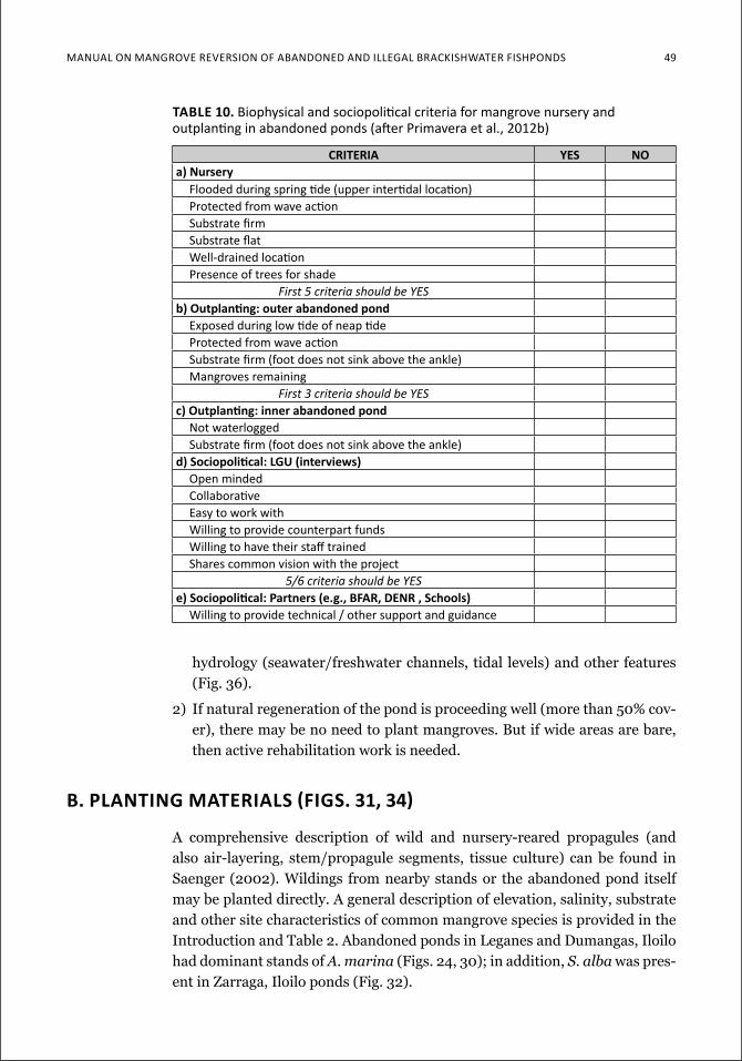
Manual on Mangrove reverSion of aBandoned and illegal BrackiSHwater fiSHPondS 49
Table 10. Biophysical and sociopolitical criteria for mangrove nursery and outplanting in abandoned ponds (after Primavera et al., 2012b)
criteria yes noa) nursery
flooded during spring tide (upper intertidal location) Protected from wave actionSubstrate firmSubstrate flat well-drained location Presence of trees for shade
First 5 criteria should be YESb) outplanting: outer abandoned pond
exposed during low tide of neap tideProtected from wave action Substrate firm (foot does not sink above the ankle) Mangroves remaining
First 3 criteria should be YESc) outplanting: inner abandoned pond
not waterlogged Substrate firm (foot does not sink above the ankle)
d) Sociopolitical: lgu (interviews)open minded collaborative easy to work with willing to provide counterpart funds willing to have their staff trained Shares common vision with the project
5/6 criteria should be YESe) Sociopolitical: Partners (e.g., bFar, denr , Schools)
willing to provide technical / other support and guidance
hydrology (seawater/freshwater channels, tidal levels) and other features (Fig. 36).
2) If natural regeneration of the pond is proceeding well (more than 50% cov-er), there may be no need to plant mangroves. But if wide areas are bare, then active rehabilitation work is needed.
b. PlanTing MaTerialS (FigS. 31, 34)
A comprehensive description of wild and nursery-reared propagules (and also air-layering, stem/propagule segments, tissue culture) can be found in Saenger (2002). Wildings from nearby stands or the abandoned pond itself may be planted directly. A general description of elevation, salinity, substrate and other site characteristics of common mangrove species is provided in the Introduction and Table 2. Abandoned ponds in Leganes and Dumangas, Iloilo had dominant stands of A. marina (Figs. 24, 30); in addition, S. alba was pres-ent in Zarraga, Iloilo ponds (Fig. 32).
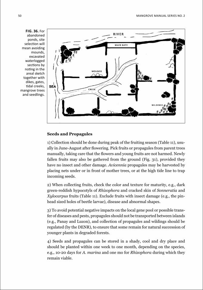
50 Mangrove Manual SerieS no. 2
seeds and propagules
1) Collection should be done during peak of the fruiting season (Table 11), usu-ally in June-August after flowering. Pick fruits or propagules from parent trees manually, taking care that the flowers and young fruits are not harmed. Newly fallen fruits may also be gathered from the ground (Fig. 31), provided they have no insect and other damage. Avicennia propagules may be harvested by placing nets under or in front of mother trees, or at the high tide line to trap incoming seeds.
2) When collecting fruits, check the color and texture for maturity, e.g., dark green-reddish hypocotyls of Rhizophora and cracked skin of Sonneratia and Xylocarpus fruits (Table 11). Exclude fruits with insect damage (e.g., the pin-head sized holes of beetle larvae), disease and abnormal shapes.
3) To avoid potential negative impacts on the local gene pool or possible trans-fer of diseases and pests, propagules should not be transported between islands (e.g., Panay and Luzon), and collection of propagules and wildings should be regulated (by the DENR), to ensure that some remain for natural succession of younger plants in degraded forests.
4) Seeds and propagules can be stored in a shady, cool and dry place and should be planted within one week to one month, depending on the species, e.g., 10-20 days for A. marina and one mo for Rhizophora during which they remain viable.
fig. 36. for abandoned ponds, site
selection will mean avoiding
mounds, excavated
waterlogged sections by
noting in the areal sketch
together with dikes, gates, tidal creeks,
mangrove trees and seedlings.
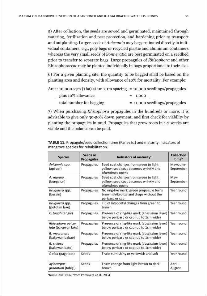
ManuaL on Mangrove reverSion of abandoned and iLLegaL brackiShwaTer fiShpondS 51
5) After collection, the seeds are sowed and germinated, maintained through watering, fertilization and pest protection, and hardening prior to transport and outplanting. Larger seeds of Avicennia may be germinated directly in indi-vidual containers, e.g., poly bags or recycled plastic and aluminum containers whereas the very small seeds of Sonneratia are best germinated on a seedbed prior to transfer to separate bags. Large propagules of Rhizophora and other Rhizophoraceae may be planted individually in bags proportional to their size.
6) For a given planting site, the quantity to be bagged shall be based on the planting area and density, with allowance of 10% for mortality. For example:
Area: 10,000 sq m (1 ha) at 1m x 1m spacing = 10,000 seedlings/propagules
plus 10% allowance = 1,000
total number for bagging = 11,000 seedlings/propagules
7) When purchasing Rhizophora propagules in the hundreds or more, it is advisable to give only 30-50% down payment, and first check for viability by planting the propagules in mud. Propagules that grow roots in 1-2 weeks are viable and the balance can be paid.
table 11. Propagule/seed collection time (Panay is.) and maturity indicators of mangrove species for rehabilitation.
species seeds or propagules indicators of maturitya Collection
timebAvicennia spp. (api-api)
propagules Seed coat changes from green to light yellow; seed coat becomes wrinkly and oftentimes opens
May/June-September
A. marina (bungalon)
propagules Seed coat changes from green to light yellow; seed coat becomes wrinkly and oftentimes opens
May-September
Bruguiera spp. (busain)
propagules no ring-like mark; green propagule turns brownish/bronze and drops without the pericarp or cap
Year round
Bruguiera spp. (pototan lake)
propagules tip of hypocotyl changes from green to brown
Year round
C. tagal (tangal) propagules Presence of ring-like mark (abscission layer) below pericarp or cap (up to 1cm wide)
Year round
Rhizophora apicu-lata (bakawan lake)
propagules Presence of ring-like mark (abscission layer) below pericarp or cap (up to 1cm wide)
Year round
R. mucronata (bakawan babae)
propagules Presence of ring-like mark (abscission layer) below pericarp or cap (up to 1cm wide)
Year round
R. stylosa (bakawan bato)
propagules Presence of ring-like mark (abscission layer) below pericarp or cap (up to 1cm wide)
Year round
S.alba (pagatpat) Seeds fruits turn shiny or yellowish and soft Year round
Xylocarpus granatum (tabigi)
Seeds fruits change from light brown to dark brown
april-august
afrom field, 1996, bfrom Primavera et al., 2004
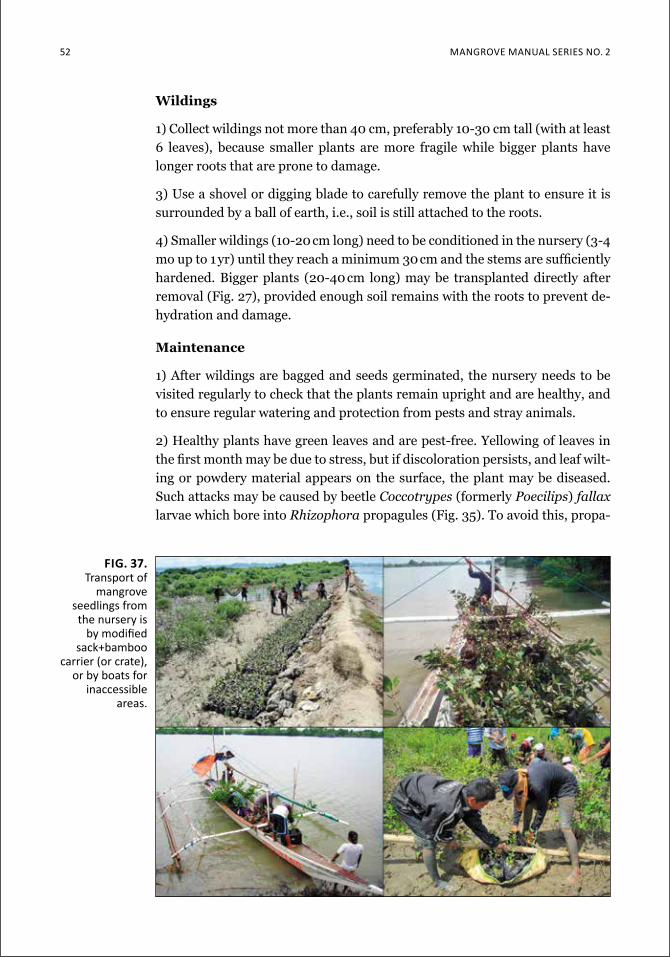
52 Mangrove Manual SerieS no. 2
Wildings
1) Collect wildings not more than 40 cm, preferably 10-30 cm tall (with at least 6 leaves), because smaller plants are more fragile while bigger plants have longer roots that are prone to damage.
3) Use a shovel or digging blade to carefully remove the plant to ensure it is surrounded by a ball of earth, i.e., soil is still attached to the roots.
4) Smaller wildings (10-20 cm long) need to be conditioned in the nursery (3-4 mo up to 1 yr) until they reach a minimum 30 cm and the stems are sufficiently hardened. Bigger plants (20-40 cm long) may be transplanted directly after removal (Fig. 27), provided enough soil remains with the roots to prevent de-hydration and damage.
Maintenance
1) After wildings are bagged and seeds germinated, the nursery needs to be visited regularly to check that the plants remain upright and are healthy, and to ensure regular watering and protection from pests and stray animals.
2) Healthy plants have green leaves and are pest-free. Yellowing of leaves in the first month may be due to stress, but if discoloration persists, and leaf wilt-ing or powdery material appears on the surface, the plant may be diseased. Such attacks may be caused by beetle Coccotrypes (formerly Poecilips) fallax larvae which bore into Rhizophora propagules (Fig. 35). To avoid this, propa-
fig. 37. transport of
mangrove seedlings from the nursery is
by modified sack+bamboo
carrier (or crate), or by boats for
inaccessible areas.
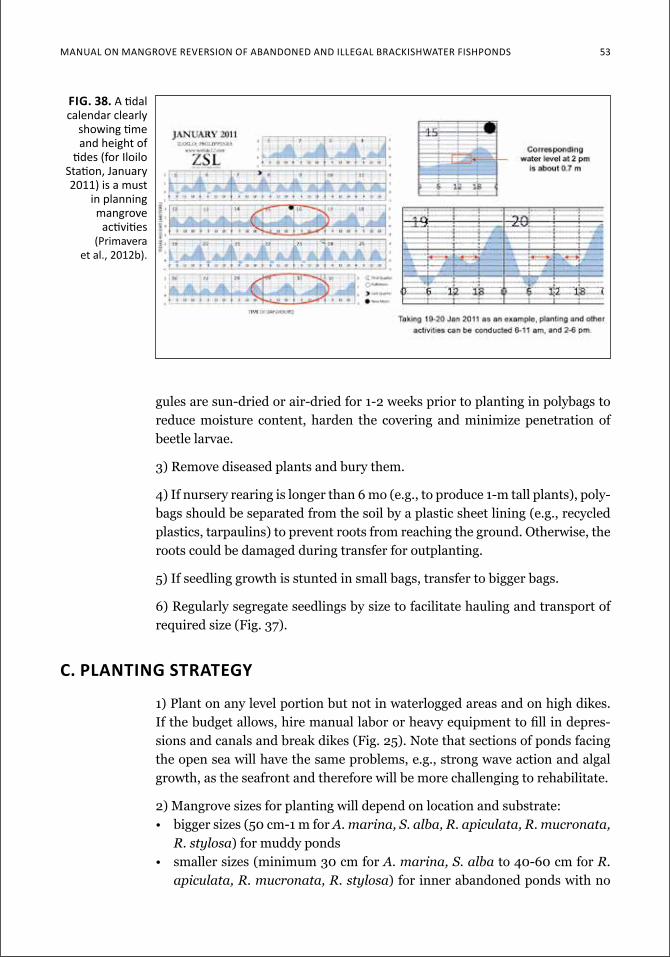
Manual on Mangrove reverSion of aBandoned and illegal BrackiSHwater fiSHPondS 53
gules are sun-dried or air-dried for 1-2 weeks prior to planting in polybags to reduce moisture content, harden the covering and minimize penetration of beetle larvae.
3) Remove diseased plants and bury them.
4) If nursery rearing is longer than 6 mo (e.g., to produce 1-m tall plants), poly-bags should be separated from the soil by a plastic sheet lining (e.g., recycled plastics, tarpaulins) to prevent roots from reaching the ground. Otherwise, the roots could be damaged during transfer for outplanting.
5) If seedling growth is stunted in small bags, transfer to bigger bags.
6) Regularly segregate seedlings by size to facilitate hauling and transport of required size (Fig. 37).
c. planting strategy
1) Plant on any level portion but not in waterlogged areas and on high dikes. If the budget allows, hire manual labor or heavy equipment to fill in depres-sions and canals and break dikes (Fig. 25). Note that sections of ponds facing the open sea will have the same problems, e.g., strong wave action and algal growth, as the seafront and therefore will be more challenging to rehabilitate.
2) Mangrove sizes for planting will depend on location and substrate:• bigger sizes (50 cm-1 m for A. marina, S. alba, R. apiculata, R. mucronata,
R. stylosa) for muddy ponds• smaller sizes (minimum 30 cm for A. marina, S. alba to 40-60 cm for R.
apiculata, R. mucronata, R. stylosa) for inner abandoned ponds with no
fig. 38. a tidal calendar clearly
showing time and height of
tides (for iloilo Station, January 2011) is a must
in planning mangrove
activities (primavera
et al., 2012b).
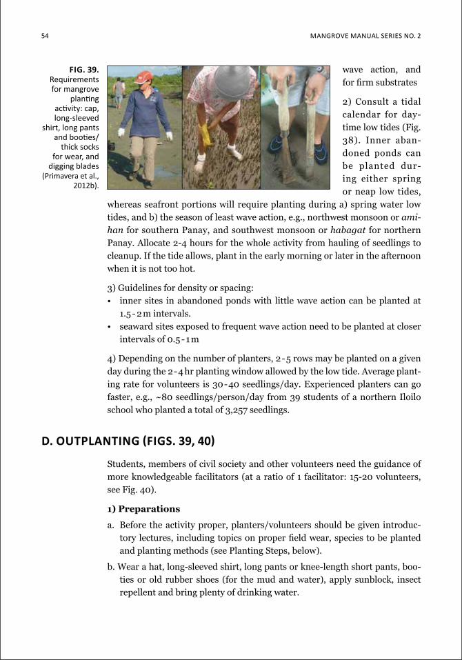
54 Mangrove Manual SerieS no. 2
wave action, and for firm substrates
2) Consult a tidal calendar for day-time low tides (Fig. 38). Inner aban-doned ponds can be planted dur-ing either spring or neap low tides,
whereas seafront portions will require planting during a) spring water low tides, and b) the season of least wave action, e.g., northwest monsoon or ami-han for southern Panay, and southwest monsoon or habagat for northern Panay. Allocate 2-4 hours for the whole activity from hauling of seedlings to cleanup. If the tide allows, plant in the early morning or later in the afternoon when it is not too hot.
3) Guidelines for density or spacing:• inner sites in abandoned ponds with little wave action can be planted at
1.5 - 2 m intervals.• seaward sites exposed to frequent wave action need to be planted at closer
intervals of 0.5 - 1 m
4) Depending on the number of planters, 2-5 rows may be planted on a given day during the 2-4 hr planting window allowed by the low tide. Average plant-ing rate for volunteers is 30-40 seedlings/day. Experienced planters can go faster, e.g., ~80 seedlings/person/day from 39 students of a northern Iloilo school who planted a total of 3,257 seedlings.
d. ouTPlanTing (FigS. 39, 40)
Students, members of civil society and other volunteers need the guidance of more knowledgeable facilitators (at a ratio of 1 facilitator: 15-20 volunteers, see Fig. 40).
1) preparations
a. Before the activity proper, planters/volunteers should be given introduc-tory lectures, including topics on proper field wear, species to be planted and planting methods (see Planting Steps, below).
b. Wear a hat, long-sleeved shirt, long pants or knee-length short pants, boo-ties or old rubber shoes (for the mud and water), apply sunblock, insect repellent and bring plenty of drinking water.
Fig. 39. requirements for mangrove
planting activity: cap, long-sleeved
shirt, long pants and booties/
thick socks for wear, and
digging blades (Primavera et al.,
2012b).
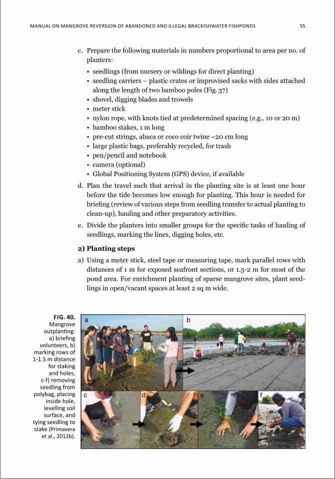
ManuaL on Mangrove reverSion of abandoned and iLLegaL brackiShwaTer fiShpondS 55
c. Prepare the following materials in numbers proportional to area per no. of planters:
• seedlings (from nursery or wildings for direct planting)• seedling carriers – plastic crates or improvised sacks with sides attached
along the length of two bamboo poles (Fig. 37)• shovel, digging blades and trowels• meter stick• nylon rope, with knots tied at predetermined spacing (e.g., 10 or 20 m)• bamboo stakes, 1 m long• pre-cut strings, abaca or coco coir twine ~20 cm long• large plastic bags, preferably recycled, for trash• pen/pencil and notebook• camera (optional)• Global Positioning System (GPS) device, if available
d. Plan the travel such that arrival in the planting site is at least one hour before the tide becomes low enough for planting. This hour is needed for briefing (review of various steps from seedling transfer to actual planting to clean-up), hauling and other preparatory activities.
e. Divide the planters into smaller groups for the specific tasks of hauling of seedlings, marking the lines, digging holes, etc.
2) planting steps
a) Using a meter stick, steel tape or measuring tape, mark parallel rows with distances of 1 m for exposed seafront sections, or 1.5-2 m for most of the pond area. For enrichment planting of sparse mangrove sites, plant seed-lings in open/vacant spaces at least 2 sq m wide.
Fig. 40. Mangrove
outplanting: a) briefing
volunteers, b) marking rows of 1-1.5 m distance
for staking and holes,
c-f) removing seedling from
polybag, placing inside hole,
levelling soil surface, and
tying seedling to stake (primavera
et al., 2012b).
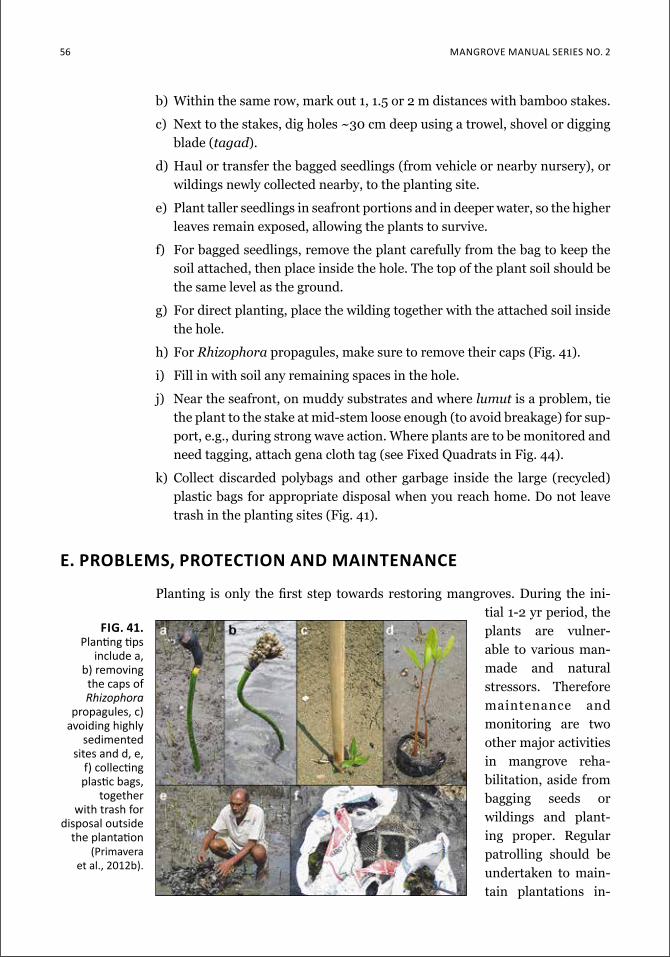
56 Mangrove Manual SerieS no. 2
b) Within the same row, mark out 1, 1.5 or 2 m distances with bamboo stakes.
c) Next to the stakes, dig holes ~30 cm deep using a trowel, shovel or digging blade (tagad).
d) Haul or transfer the bagged seedlings (from vehicle or nearby nursery), or wildings newly collected nearby, to the planting site.
e) Plant taller seedlings in seafront portions and in deeper water, so the higher leaves remain exposed, allowing the plants to survive.
f) For bagged seedlings, remove the plant carefully from the bag to keep the soil attached, then place inside the hole. The top of the plant soil should be the same level as the ground.
g) For direct planting, place the wilding together with the attached soil inside the hole.
h) For Rhizophora propagules, make sure to remove their caps (Fig. 41).
i) Fill in with soil any remaining spaces in the hole.
j) Near the seafront, on muddy substrates and where lumut is a problem, tie the plant to the stake at mid-stem loose enough (to avoid breakage) for sup-port, e.g., during strong wave action. Where plants are to be monitored and need tagging, attach gena cloth tag (see Fixed Quadrats in Fig. 44).
k) Collect discarded polybags and other garbage inside the large (recycled) plastic bags for appropriate disposal when you reach home. Do not leave trash in the planting sites (Fig. 41).
e. probleMs, protection and Maintenance
Planting is only the first step towards restoring mangroves. During the ini-tial 1-2 yr period, the plants are vulner-able to various man-made and natural stressors. Therefore maintenance and monitoring are two other major activities in mangrove reha-bilitation, aside from bagging seeds or wildings and plant-ing proper. Regular patrolling should be undertaken to main-tain plantations in-
fig. 41. Planting tips
include a, b) removing the caps of Rhizophora
propagules, c) avoiding highly
sedimented sites and d, e,
f) collecting plastic bags,
together with trash for
disposal outside the plantation
(primavera et al., 2012b).
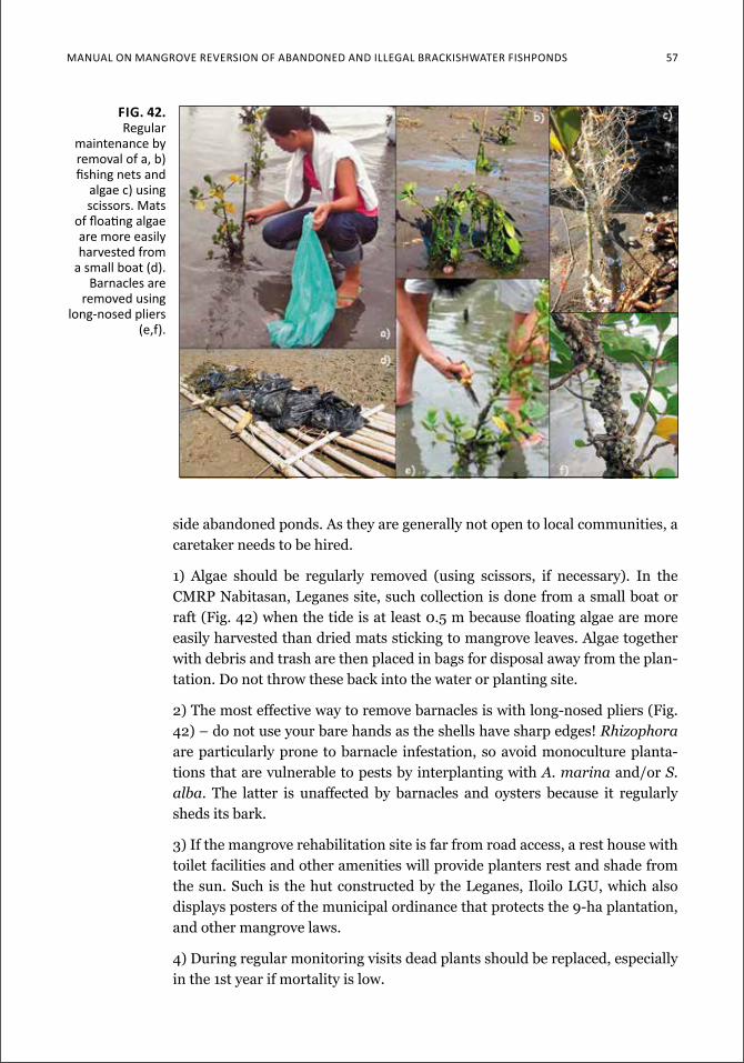
ManuaL on Mangrove reverSion of abandoned and iLLegaL brackiShwaTer fiShpondS 57
side abandoned ponds. As they are generally not open to local communities, a caretaker needs to be hired.
1) Algae should be regularly removed (using scissors, if necessary). In the CMRP Nabitasan, Leganes site, such collection is done from a small boat or raft (Fig. 42) when the tide is at least 0.5 m because floating algae are more easily harvested than dried mats sticking to mangrove leaves. Algae together with debris and trash are then placed in bags for disposal away from the plan-tation. Do not throw these back into the water or planting site.
2) The most effective way to remove barnacles is with long-nosed pliers (Fig. 42) – do not use your bare hands as the shells have sharp edges! Rhizophora are particularly prone to barnacle infestation, so avoid monoculture planta-tions that are vulnerable to pests by interplanting with A. marina and/or S. alba. The latter is unaffected by barnacles and oysters because it regularly sheds its bark.
3) If the mangrove rehabilitation site is far from road access, a rest house with toilet facilities and other amenities will provide planters rest and shade from the sun. Such is the hut constructed by the Leganes, Iloilo LGU, which also displays posters of the municipal ordinance that protects the 9-ha plantation, and other mangrove laws.
4) During regular monitoring visits dead plants should be replaced, especially in the 1st year if mortality is low.
Fig. 42. regular
maintenance by removal of a, b) fishing nets and
algae c) using scissors. Mats
of floating algae are more easily harvested from
a small boat (d). barnacles are
removed using long-nosed pliers
(e,f).
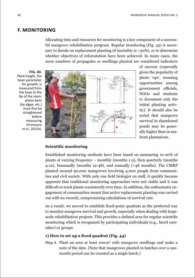
58 Mangrove Manual SerieS no. 2
f. Monitoring
Allocating time and resources for monitoring is a key component of a success-ful mangrove rehabilitation program. Regular monitoring (Fig. 43) is neces-sary to decide on replacement planting (if mortality is <30%), or to determine whether objectives of reforestation have been achieved. In many cases, the mere numbers of propagules or seedlings planted are considered indicators
of success (especially given the popularity of photo ‘ops’, meaning opportunities among government officials, NGOs and students to document only the initial planting activ-ity). It should also be noted that mangrove survival in abandoned ponds may be gener-ally higher than in sea-front plantations.
Scientific monitoring
Established monitoring methods have been based on measuring 10-20% of plants at varying frequency – monthly (months 1-3), then quarterly (months 4-12), biannually (months 12-48), and annually (>48 months). The CMRP planted around 90,000 mangroves involving 4,000 people from communi-ties and civil society. With only one field biologist on staff, it quickly became apparent that traditional monitoring approaches were not viable and it was difficult to track plants consistently over time. In addition, the enthusiastic en-gagement of communities meant that active replacement planting was carried out with no records, compromising calculations of survival rate.
As a result, we moved to establish fixed-point quadrats as the preferred way to monitor mangrove survival and growth, especially when dealing with large-scale rehabilitation projects. This provides a defined area for regular scientific monitoring which is recognized by participating individuals (e.g., hired care-taker) or groups.
1) How to set up a fixed quadrat (Fig. 44)
Step A Plant an area at least 100 m2 with mangrove seedlings and make a note of the date. (Note that mangroves planted in batches over a one-month period can be counted as a single batch.)
fig. 43. Plant height, the basic parameter
for growth, is measured from the base to the tip of the stem;
plants bent (by algae, etc.)
must first be straightened
before measuring (primavera
et al., 2012b).
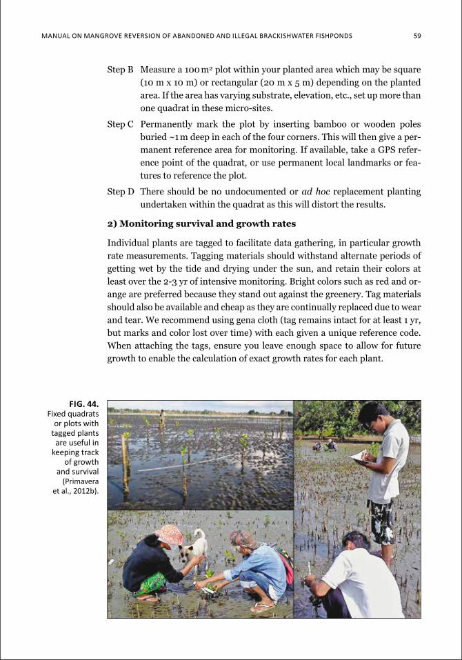
Manual on Mangrove reverSion of aBandoned and illegal BrackiSHwater fiSHPondS 59
Step B Measure a 100 m2 plot within your planted area which may be square (10 m x 10 m) or rectangular (20 m x 5 m) depending on the planted area. If the area has varying substrate, elevation, etc., set up more than one quadrat in these micro-sites.
Step C Permanently mark the plot by inserting bamboo or wooden poles buried ~1 m deep in each of the four corners. This will then give a per-manent reference area for monitoring. If available, take a GPS refer-ence point of the quadrat, or use permanent local landmarks or fea-tures to reference the plot.
Step D There should be no undocumented or ad hoc replacement planting undertaken within the quadrat as this will distort the results.
2) Monitoring survival and growth rates
Individual plants are tagged to facilitate data gathering, in particular growth rate measurements. Tagging materials should withstand alternate periods of getting wet by the tide and drying under the sun, and retain their colors at least over the 2-3 yr of intensive monitoring. Bright colors such as red and or-ange are preferred because they stand out against the greenery. Tag materials should also be available and cheap as they are continually replaced due to wear and tear. We recommend using gena cloth (tag remains intact for at least 1 yr, but marks and color lost over time) with each given a unique reference code. When attaching the tags, ensure you leave enough space to allow for future growth to enable the calculation of exact growth rates for each plant.
fig. 44. fixed quadrats
or plots with tagged plants
are useful in keeping track
of growth and survival
(primavera et al., 2012b).
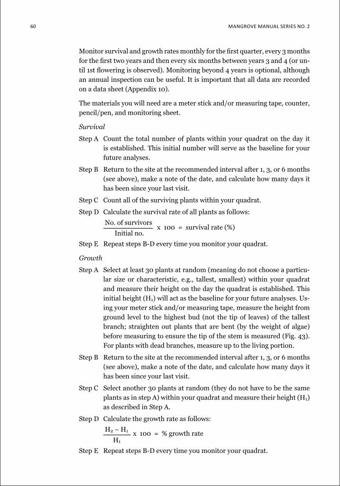
60 Mangrove Manual SerieS no. 2
Monitor survival and growth rates monthly for the first quarter, every 3 months for the first two years and then every six months between years 3 and 4 (or un-til 1st flowering is observed). Monitoring beyond 4 years is optional, although an annual inspection can be useful. It is important that all data are recorded on a data sheet (Appendix 10).
The materials you will need are a meter stick and/or measuring tape, counter, pencil/pen, and monitoring sheet.
Survival
Step A Count the total number of plants within your quadrat on the day it is established. This initial number will serve as the baseline for your future analyses.
Step B Return to the site at the recommended interval after 1, 3, or 6 months (see above), make a note of the date, and calculate how many days it has been since your last visit.
Step C Count all of the surviving plants within your quadrat.
Step D Calculate the survival rate of all plants as follows:
No. of survivors x 100 = survival rate (%)
Initial no.
Step E Repeat steps B-D every time you monitor your quadrat.
Growth
Step A Select at least 30 plants at random (meaning do not choose a particu-lar size or characteristic, e.g., tallest, smallest) within your quadrat and measure their height on the day the quadrat is established. This initial height (H1) will act as the baseline for your future analyses. Us-ing your meter stick and/or measuring tape, measure the height from ground level to the highest bud (not the tip of leaves) of the tallest branch; straighten out plants that are bent (by the weight of algae) before measuring to ensure the tip of the stem is measured (Fig. 43). For plants with dead branches, measure up to the living portion.
Step B Return to the site at the recommended interval after 1, 3, or 6 months (see above), make a note of the date, and calculate how many days it has been since your last visit.
Step C Select another 30 plants at random (they do not have to be the same plants as in step A) within your quadrat and measure their height (H1) as described in Step A.
Step D Calculate the growth rate as follows:
H2 – H1 x 100 = % growth rate H1
Step E Repeat steps B-D every time you monitor your quadrat.

Manual on Mangrove reverSion of aBandoned and illegal BrackiSHwater fiSHPondS 61
The above monitoring scheme allows you to track the success of your plan-tation in terms of growth and survival. A more complex tool is Mangrove Community Structure (MCS) analysis (English et al., 1994) which measures mangrove density, biomass and species diversity, among other parameters. Success of mangrove restoration may be assessed by the degree of conver-gence of the restored site with a natural forest (Kaly and Jones, 1998). Natural colonization of an idle shrimp pond in Central America reported mangrove biomass (measured as basal area) levels at 62.4% of a control forest with the same complement of species 10 years after tidal flow returned (Lewis and Mar-shall, 1997). In Batangas, northen Philippines species diversity H’ of a 50-yr regenerated pond exceeded that of a nearby natural forest (0.78 vs 0.58). This pond was among three which had naturally reverted to mangroves over 5, 15 and >50 years (Primavera et al., 2012a). Mangrove counts of 3,000 stems/ha for trees and saplings in the 50-yr forest were comparable to those of two natural forests (3,150-3,550 stems/ha), whereas lower counts were observed in the 15-year pond (1,300/ha) and 5-year pond (700/ha). Biomass, expressed as stand basal area (SBA), was the same (46 m2/ha) in the two natural forests in contrast to the low values (7-8.6 m2/ha) for the regenerating sites.
Aside from floral succession and mangrove survival, rehabilitation success can also be evaluated through environmental factors, sustainable exploitation, ecosystem functioning and faunal recruitment (return of fish, crustaceans and
box 9. Zamboanga del Sur Mangroves and abandoned pondsthe success story of vincenzo Sagun town in Zamboanga del Sur is one of mangrove destruction and subsequent rehabilitation by the local community, with the continuing support of various ngos and lgus. large tracts of the 496-ha mangrove area were cleared for pond development in the 1980s-1990s. this negatively impacted livelihoods (from reduced fish catches), compromised food security (no more shellfish gleaning), and threatened safety of fishers (from storms and pirates in offshore waters).
from 1992 through 2010, mangrove reforestation and crM programs were initiated and funded by a series of ngos – PaMalakaYa, coSeed, lutheran world Service, christian aid and Philippine tropical forest conservation foundation (Ptfcf). the latter collaborated with coSeed on a project which rehabilitated more than 200 ha of mangroves, including 26.5 ha of abandoned ponds. with the Po-ngo-lgu networking efforts, thousands of hectares of mangroves and abandoned ponds have been turned over to the local government and protected by a municipal ordinance that also established a fish sanctuary.
aside from lgu involvement, enabling factors were the empowerment of the community itself through ngo support, effective iec (e.g., training courses, billboards), and conversion of poachers and illegal pond operators to mangrove conservationists. the Bgy. Bantay katunggan task force (BBktf) was integrated into the Municipal development Plan and deputized to apprehend violators. BBktf members were provided zero interest loans, free health insurance, patrol equipment and gears, guardhouse and mangrove footwalk. two decades of mangrove and crM initiatives have stopped mangrove cutting and illegal fishing; restored fish and wildlife diversity, increased fisheries catches and fishers’ income, and allowed women to harvest shellfish once more and men to fish in the safety of municipal waters.
62 Mangrove Manual SerieS no. 2
mollusks) (Kaly and Jones, 1998; Bosire et al., 2008). Mangrove rehabilitation in Vincenzo Sagun, Zamboanga del Sur is a success story of restored biodiver-sity, increased fish catches and fishers’ incomes, and women’s contribution to food security from 200 ha of restored mangroves and reverted ponds (Box 9).
Structural development and ecological functioning (fish populations, accre-tion rates and sedimentological characteristics, other faunal and floral proper-ties) have been compared between restored and natural mangrove forests in Australia, New Zealand and Florida, USA (Saenger, 2002).
conclusion
The 4:1 mangrove-pond ratio required for environmental sustainability can be achieved by either seafront planting or reversion of abandoned ponds. Al-though very popular due to open access of beaches, the former gives high mor-tality rates because of wave action. An added factor is the lowered elevation, no longer suitable for mangrove survival, due to scouring of the substrate with the loss of fringing mangroves. Therefore it is pond reversion which will give back mangroves in the thousands of hectares needed for the 4:1 ratio.
As the first step in moving forward, this Manual describes low to zero con-tact protocols for determining pond tenure. Equally important, it shows that the AUU portion of FLA ponds is too small (possibly less than 2.5% of to-tal brackishwater pond area) to achieve the required hectarage for reversion. Meanwhile, up to 40% of fishponds are estimated to be either covered only by tax declaration (and therefore not legal), completely undocumented or misde-clared, and can therefore be targeted for mangrove restoration. Food security is not an issue as brackishwater production of milkfish contributes only 10.3% of total fish production by volume from all sources (based on 2012 statistics) and can be replaced by production from open water aquaculture.
Given this perspective and with these tools, NGOs and POs can actively engage local governments and national agencies in restoring mangroves side-by-side with ponds but with a balance that is ecologically sustainable and socially re-sponsible.
Manual on Mangrove reverSion of aBandoned and illegal BrackiSHwater fiSHPondS 63
referencesApud FD, Primavera JH, Torres PL Jr. 1985. Farming of prawns and shrimps.
Aquaculture Extension Manual No. 5, SEAFDEC Aquaculture Department, Il-oilo, Philippines. 66 p.
Baconguis SR, Moreno MLQ. 1995. Algal bloom: Its cause and impact to man-grove plantation and potential utilization in Siargao Island, Surigao del Norte. The Philippine Lumberman, May-June 1995: 12-16
Bagarinao TU, Primavera JH. 2005. Code of Practice for Sustainable Use of Man-grove Ecosystems for Aquaculture in Southeast Asia, SEAFDEC Aquaculture Department, Iloilo, Philippines
Barbier EB, Hacker SD, Kennedy C, Koch EW, Stier AC, Silliman BR. 2011. The value of estuarine and coastal ecosystem services. Ecol. Monogr. 81 (2): 169-193
Bosire JO, Dahdouh-Guebas F, Walton M, Crona BI, Lewis III RR, Field C, Kairo JG, Koedam N. 2008. Functionality of restored mangroves: a review. Aquatic Bot. 89: 251-259
Brown B. 2006. 5 Steps to successful, ecological mangrove rehabilitation. Man-grove Action Project and Yayasan Akar Rumput Laut, Yogyakarta, Indonesia. 51 p.
Brown WH, Fischer AF. 1918. Philippine mangrove swamps. Bulletin No. 17, Bu-reau of Forestry, Department of Agriculture and Natural Resources, Manila
Buduan ED, Ballon R. 2012. Propagation techniques for Sonneratia alba (Pagat-pat) seeds. National Mangrove Conference, ZSL-GIZ-DENR, Iloilo City, 18-20 April 2012 (unpub. ms.)
Carbine WF. 1948. Bangos culture in the Philippines. Prog. Fish. Cult. 10: 187-197
Duke NC. 2006. Australia’s mangroves. University of Queensland, Brisbane, Aus-tralia. 200 p.
Ellison AM. 2000. Mangrove restoration: do we know enough? Rest. Ecol. 8 (3): 219–229
English S, Wilkinson C, Baker V (eds). 1994. Survey Manual for Tropical Marine Resources. Australian Institute for Marine Science, Townsville, Australia
Ferrer AJG, Hopanda J, Orquejo M, Moscoso AD, Sadaba R. 2011. Reversion of disused Fishpond Lease Agreement areas to mangrove forests in Region VI, Philippines. EEPSEA Research Report No. 2011-RR9. Singapore: Economy and Environment Program for Southeast Asia (EEPSEA)
Ferrer AJG, Hopanda J, Orquejo M, Moscoso AD. 2012. Disused fishpond areas covered by fishpond lease agreement in Western Visayas. Quezon City, Philip-pines: Department of Agriculture-Bureau of Fisheries and Aquatic Resources
Field CD (ed). 1996. Restoration of mangrove ecosystems. International Society of Mangrove Ecosystems and ITTO, Okinawa, Japan. 250 p.
Giri C, Ochieng E, Tieszen L, Zhu Z, Singh A, Loveland T, Masek J, Duke N. 2010. Status and distribution of mangrove forests of the world using earth observation satellite data. Global Ecol. and Biogeo.: 1-6. DOI: 10.1111/j.1466-8238.2010.00584.x
64 Mangrove Manual SerieS no. 2
Hortillosa E. 2008. Mangrove floristics and community structure in Iloilo Prov-ince, Panay Island, Philippines. Unpub. M.S. thesis, University of the Philip-pines - Visayas, Iloilo City
Jamandre TJ, Rabanal HR. 1975. Engineering aspects of brackishwater aqua-culture in the South China Sea region: Indonesia, Malaysia, Philippines, Sin-gapore, Thailand, Hong Kong. South China Sea Fisheries Development and Coordinating Programme, Manila, Philippines SCS/75/WP/16:96p.
Kaly UL, Jones GP. 1998. Mangrove restoration: A potential tool for coastal management in tropical developing countries. Ambio 27: 656-661.
Kitaya Y, Jintna V, Piriyayotha S, Jaijing D, Yabuki K, Izutani S, Nishimaya A, Iwasaki M. 2002. Early growth of seven mangrove species planted at different elevations in a Thai estuary. Trees 16: 150-154
Kjerfve B. 1990. Manual for investigation of hydrological processes in mangrove ecosystems. UNESCO/UNDP Regional Project (RAS/86/120), 79 p.
Lewis RR, Marshall MJ. 1997. Principles of successful restoration of shrimp aquaculture ponds back to mangrove forests. Programa/resumes de Marcuba ’97, September 15/20, Palacio de Convenciones de La Habana, Cuba, 126 p.
Ling SW. 1977. Aquaculture in Southeast Asia – a historical overview. Seattle, WA: University of Washington. 108 p.
Long JB, Giri CP. 2011. Mapping the Philippines’ mangrove forests using Land-sat imagery. Sensors 11 (3): 2972-2981
Long J, Napton D, Giri C, Graesser J. 2013. A mapping and monitoring assess-ment of the Philippines’ mangrove forests from 1990 to 2010. J. Coastal Re-search. DOI. 10.112/JCOASTRES-D-13.00057.1
Lugo AE, Snedaker SC. 1974. The ecology of mangroves. Ann. Rev. Ecol. System. 5: 39-64
Matsui M, Suekuni J, Nogami M, Havanond S, Salikul P. 2010. Mangrove re-habilitation dynamics and soil organic carbon change as a result of full hy-draulic restoration and regarding of a previously intensively managed shrimp pond. Wetland Ecol. Manag. 18: 233-242
Maxwell GS, Li SW. 2006. Barnacle infestation on the bark of Kandelia candel (L.) Druce and Aegiceras corniculatum (L.) Blanco. ISME/GLOMIS Elec-tronic Journal 5 (2)
Melana DM, Atchue J III, Yao CE, Edwards R, Melana EE, Gonzales HI. 2000. Mangrove Management Handbook. Department of Environment and Natural Resources, Manila, Philippines through the Coastal Resource Management Project, Cebu, Philippines, 96 p.
Millennium Ecosystem Assessment. 2005. Ecosystems and Human Well-being: Synthesis. Island Press, Wash. DC. 137 p.
Polidoro BA, Carpenter KE, Collins L, Duke NC, Ellison AM, Ellison JC, Farn-sworth EJ, Fernando ES, Kathiresan K, Koedam NE, Livingstone SR, Miyagi T, Moore GE, Nam VN, Ong JE, Primavera JH, Salmo SG III, Sanciangco JC, Sukardjo S, Wang Y, Yong JWH. 2010. The loss of species: Mangrove extinc-tion risk and geographic areas of global concern. PLoS ONE 5(4): e10095. doi:10.1371/journal.pone.0010095
Manual on Mangrove reverSion of aBandoned and illegal BrackiSHwater fiSHPondS 65
Primavera JH. 1993. A critical review of shrimp pond culture in the Philippines. Rev. Fish. Sci. 1: 151-201
Primavera, J.H. 1995. Mangroves and brackishwater pond culture in the Philip-pines. Hydrobiologia 295: 303-309.
Primavera JH. 2000a. Development and conservation of Philippine mangroves: institutional issues. Ecological Economics 35 (1): 91-106
Primavera JH. 2000b. Integrated mangrove-aquaculture systems in Asia. Inte-grated Coastal Zone Management. Autumn edition, 121-130
Primavera JH. 2005. Mangroves, fishponds, and the quest for sustainability. Sci-ence 310 (5745): 57-59
Primavera JH (ed). 2011. Proceedings of the Seminar-Workshop on Cancella-tion and Mangrove Reversion of Abandoned, Undeveloped and Underutilized Fishpond Lease Agreement (AUU-FLA) Ponds, Iloilo City, 28-30 July 2010. Zoological Society of London and Deutsche Gesellschaft für Internationale Zusammenarbeit.77 p.
Primavera JH, Esteban JMA. 2008. A review of mangrove rehabilitation in the Philippines: successes, failures and future prospects. Wetlands Ecol. Manage. 16 (3): 173-253.
Primavera JH, Rollon RN, Samson MS. 2012a. The pressing challenges of man-grove rehabilitation: Pond reversion and coastal protection, pp. 217-244. In: Chicharo L, Zalewski M (eds) Chapter 10 in Vol. 10: Ecohydrology and Res-toration, in: Wolanski E, McLusky D (Series eds) Treatise on Estuarine and Coastal Science, Elsevier, Amsterdam
Primavera JH, Sadaba RB, Lebata MJHL, Altamirano JP. 2004. Handbook of Mangroves in the Philippines – Panay. SEAFDEC Aquaculture Department (Philippines) and UNESCO Man and the Biosphere ASPACO Project, 106 p.
Primavera JH, Altamirano JP, Lebata MJHL, delos Reyes AA Jr., Pitogo CL. 2007. Mangroves and shrimp pond culture effluents in Aklan, Panay Is., cen-tral Philippines. Bull. Mar. Sci. 80: 795-804
Primavera JH, Binas JB, Samonte-Tan GP, Lebata MJHL, Alava VR, Walton M, LeVay L. 2009. Mud crab pen culture – replacement of fish feed requirement and impacts on mangrove community structure. Aquacult. Res. 41: 1211-1220
Primavera JH, Savaris JP, Bajoyo BE, Coching JD, Curnick DJ, Golbeque RL, Guzman AT, Henderin JQ, Joven RV, Loma RA, Koldewey HJ. 2012b. Manu-al on community-based mangrove rehabilitation – Mangrove Manual Series No. 1. London, UK: ZSL. 240 p.
Saenger P. 2002. Mangrove Ecology, Silviculture and Conservation. Dordrecht, Kluwer Publishers. 360 p.
Saenger P, Hegerl EJ, Davie JDS. 1983. Global status of mangrove ecosystems. IUCN Commission on Ecology Papers No. 3, Gland, Switzerland
Sage, P.S., 2009. Parasitic outbreaks upon Avicennia marina within Kalibo mangrove. Unpub. report, 14 Feb. 2009
Samson MS, Rollon RN. 2008. Growth performance of mangroves at the en-hancement sites: need to revisit forest management strategies. Ambio 37 (4): 234-240
66 Mangrove Manual SerieS no. 2
Sen TM, Tan DV, Anh PH, Miyamoto C, Suda S, Asano T. 2004. Effects of some ecological factors and planting techniques on the survival rate and growth per-formance of Sonneratia caseolaris (L.) Engler in Thai Binh and Nam Dinh provinces, pp. 253-270. In: Hong PN (ed). Mangrove ecosystem in the Red River Delta Zone. Vietnam National University, Center for Natural Resources and Environmental Studies, and Mangrove Ecosystem Research Division, Ha-noi. Agricultural Publishing House, Hanoi
Sheue C-R, Liu H-Y, Yong JWH. 2003. Kandelia obovata (Rhizophoraceae), a new mangrove species from Eastern Asia. Taxon 52: 287-294
Siddall SE, Atchue JA III, Murray PL Jr. 1985. Mariculture development in man-groves: a case study of the Philippines, Panama and Ecuador. In: Clark JR (ed) Coastal Resources Management: Development Case Studies, Renewable Re-sources Information Series, Coastal Management Pub. No. 3. Prepared for the National Park Service, U.S. Dept. of the Interior, and the U.S. Agency for In-ternational Development. Research Planning Institute, Inc., Columbia, South Carolina, USA
Spalding M, Blasco F, Field C. 1997. World mangrove atlas. The International Society for Mangrove Ecosystems, Okinawa
Spalding M, Kainuma M, Collins L. 2010. World Atlas of Mangroves. The Interna-tional Society for Mangrove Ecosystems, Okinawa, Japan, 319 p.
Stevenson NJ, Lewis III RR, Burbridge PR. 1999. Disused shrimp ponds and mangrove rehabilitation, pp. 277-297. In W. Streever (ed) An International Perspective on Wetland Rehabilitation, Kluwer, Netherlands
Tantipuknont S, Paphavasit N, Aksornkae S. 1994. Growth and survival rate of three mangrove seedlings planted on the abandoned shrimp pond, Chang-wat Samutsongkram, pp. 373-375. In: Sudara S, Wilkinson C, Chou LM (eds). Proceedings of the Third ASEAN-Australia Symposium on Living Coastal Re-sources. Townsville, Australia: Australian Institute of Marine Science
Thampanya U, Vermaat JE, Duarte CM. 2002. Colonization success of common Thai mangrove species as a function of exposure to water turbulence. Mar. Ecol. Progr. Ser. 237: 111-120
Van Spreybroeck D, 1992. Regeneration strategy of mangroves along the Kenya coast: a first approach. Hydrobiologia, 247: 243-251
Yap WG. 1999. Rural Aquaculture in the Philippines. RAP Publications 1999/20. Food and Agriculture Organization of the United Nations Regional Office for Asia and the Pacific. Bangkok, Thailand
Yap WG. 2007. Assessment of FLA holdings in four pilot regions. Strategy for Sustainable Aquaculture Development for Poverty Reduction, Philippines (ADTA 4708-PHI), PRIMEX, Manila. Unpub. report. 33 p.
Yap WG, Villaluz AC. 2010. Milkfish production systems in brackishwater ponds in the Philippines, pp. 71-87. In: IC Liao, EM Leano (eds) Milkfish Aquaculture in Asia. National Taiwan University, Fisheries Society of Taiwan, Asian Fisher-ies Society (Malaysia), and World Aquaculture Society
ZSL-CMRP. 2013. Terminal Report – Identifying brackishwater fishponds, and establishing biophysical protocols, for mangrove reversion in Panay Island: A climate change mitigation strategy. Submitted to GIZ
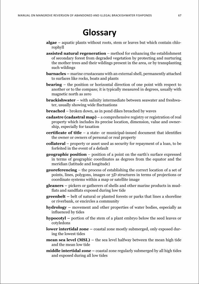
Manual on Mangrove reverSion of aBandoned and illegal BrackiSHwater fiSHPondS 67
glossaryalgae – aquatic plants without roots, stem or leaves but which contain chlo-
rophyll
assisted natural regeneration – method for enhancing the establishment of secondary forest from degraded vegetation by protecting and nurturing the mother trees and their wildings present in the area, or by transplanting such wildings
barnacles – marine crustaceans with an external shell, permanently attached to surfaces like rocks, boats and plants
bearing – the position or horizontal direction of one point with respect to another or to the compass; it is typically measured in degrees, usually with magnetic north as zero
brackishwater – with salinity intermediate between seawater and freshwa-ter, usually showing wide fluctuations
breached – broken down, as in pond dikes breached by waves
cadastre (cadastral map) – a comprehensive registry or registration of real property which includes its precise location, dimension, value and owner-ship, especially for taxation
certificate of title – a state- or municipal-issued document that identifies the owner or owners of personal or real property
collateral – property or asset used as security for repayment of a loan, to be forfeited in the event of a default
geographic position – position of a point on the earth’s surface expressed in terms of geographic coordinates as degrees from the equator and the meridian (latitude and longitude)
georeferencing – the process of establishing the correct location of a set of points, lines, polygons, images or 3D structures in terms of projections or coordinate systems within a map or satellite image
gleaners – pickers or gatherers of shells and other marine products in mud-flats and sandflats exposed during low tide
greenbelt – belt of natural or planted forests or parks that lines a shoreline or riverbank, or encircles a community
hydrology – movement and other properties of water bodies, especially as influenced by tides
hypocotyl – portion of the stem of a plant embryo below the seed leaves or cotyledons
lower intertidal zone – coastal zone mostly submerged, only exposed dur-ing the lowest tides
mean sea level (MSL) – the sea level halfway between the mean high tide and the mean low tide
middle intertidal zone – coastal zone regularly submerged by all high tides and exposed during all low tides
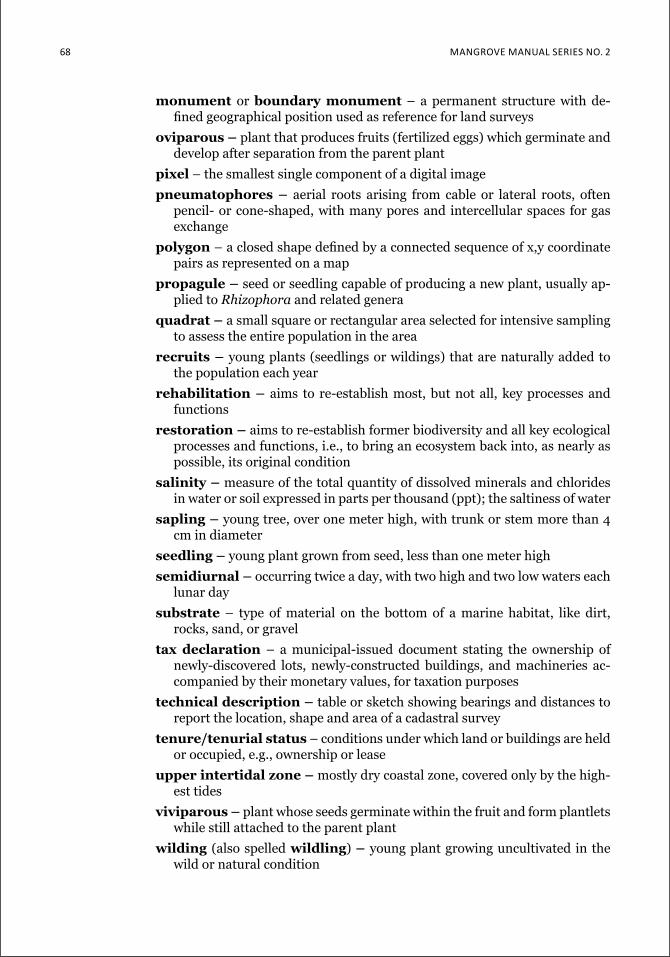
68 Mangrove Manual SerieS no. 2
monument or boundary monument – a permanent structure with de-fined geographical position used as reference for land surveys
oviparous – plant that produces fruits (fertilized eggs) which germinate and develop after separation from the parent plant
pixel – the smallest single component of a digital image
pneumatophores – aerial roots arising from cable or lateral roots, often pencil- or cone-shaped, with many pores and intercellular spaces for gas exchange
polygon – a closed shape defined by a connected sequence of x,y coordinate pairs as represented on a map
propagule – seed or seedling capable of producing a new plant, usually ap-plied to Rhizophora and related genera
quadrat – a small square or rectangular area selected for intensive sampling to assess the entire population in the area
recruits – young plants (seedlings or wildings) that are naturally added to the population each year
rehabilitation – aims to re-establish most, but not all, key processes and functions
restoration – aims to re-establish former biodiversity and all key ecological processes and functions, i.e., to bring an ecosystem back into, as nearly as possible, its original condition
salinity – measure of the total quantity of dissolved minerals and chlorides in water or soil expressed in parts per thousand (ppt); the saltiness of water
sapling – young tree, over one meter high, with trunk or stem more than 4 cm in diameter
seedling – young plant grown from seed, less than one meter high
semidiurnal – occurring twice a day, with two high and two low waters each lunar day
substrate – type of material on the bottom of a marine habitat, like dirt, rocks, sand, or gravel
tax declaration – a municipal-issued document stating the ownership of newly-discovered lots, newly-constructed buildings, and machineries ac-companied by their monetary values, for taxation purposes
technical description – table or sketch showing bearings and distances to report the location, shape and area of a cadastral survey
tenure/tenurial status – conditions under which land or buildings are held or occupied, e.g., ownership or lease
upper intertidal zone – mostly dry coastal zone, covered only by the high-est tides
viviparous – plant whose seeds germinate within the fruit and form plantlets while still attached to the parent plant
wilding (also spelled wildling) – young plant growing uncultivated in the wild or natural condition

a P P e n d i x 3 69

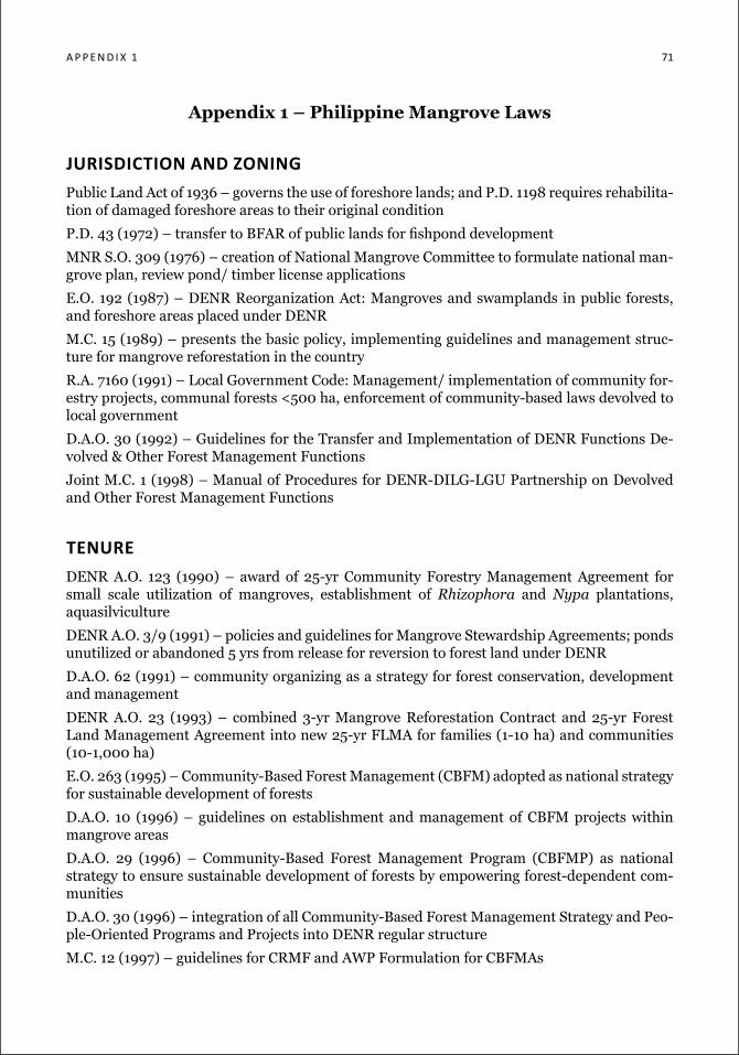
a p p e n d i x 1 71
Appendix 1 – Philippine Mangrove Laws
Jurisdiction and ZoningPublic Land Act of 1936 – governs the use of foreshore lands; and P.D. 1198 requires rehabilita-tion of damaged foreshore areas to their original condition
P.D. 43 (1972) – transfer to BFAR of public lands for fishpond development
MNR S.O. 309 (1976) – creation of National Mangrove Committee to formulate national man-grove plan, review pond/ timber license applications
E.O. 192 (1987) – DENR Reorganization Act: Mangroves and swamplands in public forests, and foreshore areas placed under DENR
M.C. 15 (1989) – presents the basic policy, implementing guidelines and management struc-ture for mangrove reforestation in the country
R.A. 7160 (1991) – Local Government Code: Management/ implementation of community for-estry projects, communal forests <500 ha, enforcement of community-based laws devolved to local government
D.A.O. 30 (1992) – Guidelines for the Transfer and Implementation of DENR Functions De-volved & Other Forest Management Functions
Joint M.C. 1 (1998) – Manual of Procedures for DENR-DILG-LGU Partnership on Devolved and Other Forest Management Functions
tenureDENR A.O. 123 (1990) – award of 25-yr Community Forestry Management Agreement for small scale utilization of mangroves, establishment of Rhizophora and Nypa plantations, aquasilviculture
DENR A.O. 3/9 (1991) – policies and guidelines for Mangrove Stewardship Agreements; ponds unutilized or abandoned 5 yrs from release for reversion to forest land under DENR
D.A.O. 62 (1991) – community organizing as a strategy for forest conservation, development and management
DENR A.O. 23 (1993) – combined 3-yr Mangrove Reforestation Contract and 25-yr Forest Land Management Agreement into new 25-yr FLMA for families (1-10 ha) and communities (10-1,000 ha)
E.O. 263 (1995) – Community-Based Forest Management (CBFM) adopted as national strategy for sustainable development of forests
D.A.O. 10 (1996) – guidelines on establishment and management of CBFM projects within mangrove areas
D.A.O. 29 (1996) – Community-Based Forest Management Program (CBFMP) as national strategy to ensure sustainable development of forests by empowering forest-dependent com-munities
D.A.O. 30 (1996) – integration of all Community-Based Forest Management Strategy and Peo-ple-Oriented Programs and Projects into DENR regular structure
M.C. 12 (1997) – guidelines for CRMF and AWP Formulation for CBFMAs
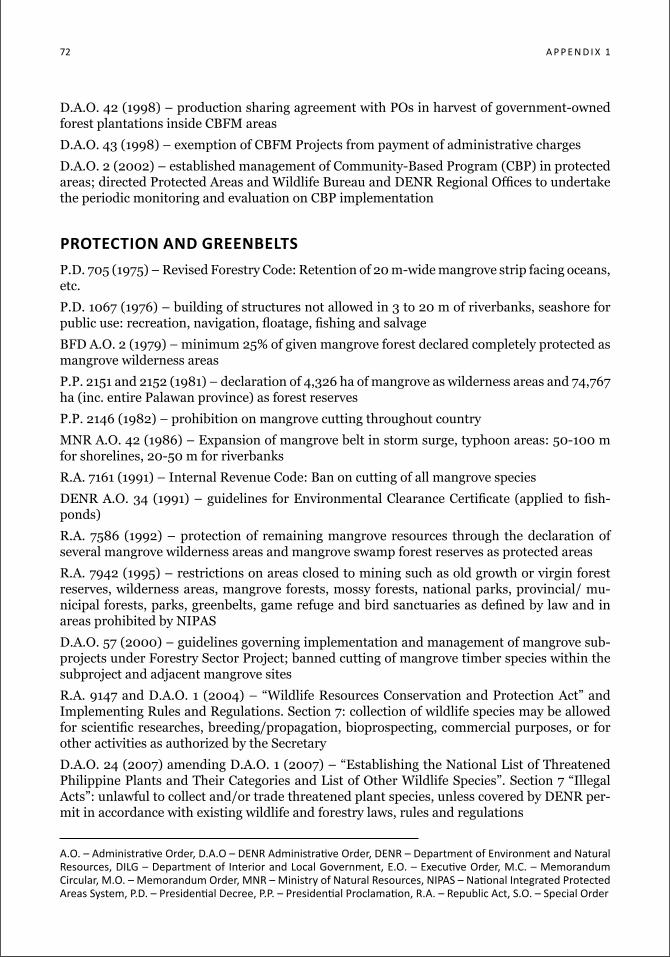
72 a p p e n d i x 1
D.A.O. 42 (1998) – production sharing agreement with POs in harvest of government-owned forest plantations inside CBFM areas
D.A.O. 43 (1998) – exemption of CBFM Projects from payment of administrative charges
D.A.O. 2 (2002) – established management of Community-Based Program (CBP) in protected areas; directed Protected Areas and Wildlife Bureau and DENR Regional Offices to undertake the periodic monitoring and evaluation on CBP implementation
protection and greenbeltsP.D. 705 (1975) – Revised Forestry Code: Retention of 20 m-wide mangrove strip facing oceans, etc.
P.D. 1067 (1976) – building of structures not allowed in 3 to 20 m of riverbanks, seashore for public use: recreation, navigation, floatage, fishing and salvage
BFD A.O. 2 (1979) – minimum 25% of given mangrove forest declared completely protected as mangrove wilderness areas
P.P. 2151 and 2152 (1981) – declaration of 4,326 ha of mangrove as wilderness areas and 74,767 ha (inc. entire Palawan province) as forest reserves
P.P. 2146 (1982) – prohibition on mangrove cutting throughout country
MNR A.O. 42 (1986) – Expansion of mangrove belt in storm surge, typhoon areas: 50-100 m for shorelines, 20-50 m for riverbanks
R.A. 7161 (1991) – Internal Revenue Code: Ban on cutting of all mangrove species
DENR A.O. 34 (1991) – guidelines for Environmental Clearance Certificate (applied to fish-ponds)
R.A. 7586 (1992) – protection of remaining mangrove resources through the declaration of several mangrove wilderness areas and mangrove swamp forest reserves as protected areas
R.A. 7942 (1995) – restrictions on areas closed to mining such as old growth or virgin forest reserves, wilderness areas, mangrove forests, mossy forests, national parks, provincial/ mu-nicipal forests, parks, greenbelts, game refuge and bird sanctuaries as defined by law and in areas prohibited by NIPAS
D.A.O. 57 (2000) – guidelines governing implementation and management of mangrove sub-projects under Forestry Sector Project; banned cutting of mangrove timber species within the subproject and adjacent mangrove sites
R.A. 9147 and D.A.O. 1 (2004) – “Wildlife Resources Conservation and Protection Act” and Implementing Rules and Regulations. Section 7: collection of wildlife species may be allowed for scientific researches, breeding/propagation, bioprospecting, commercial purposes, or for other activities as authorized by the Secretary
D.A.O. 24 (2007) amending D.A.O. 1 (2007) – “Establishing the National List of Threatened Philippine Plants and Their Categories and List of Other Wildlife Species”. Section 7 “Illegal Acts”: unlawful to collect and/or trade threatened plant species, unless covered by DENR per-mit in accordance with existing wildlife and forestry laws, rules and regulations
a.o. – administrative order, d.a.o – denr administrative order, denr – department of environment and natural resources, dilg – department of interior and local government, e.o. – executive order, M.c. – Memorandum circular, M.o. – Memorandum order, Mnr – Ministry of natural resources, niPaS – national integrated Protected areas System, P.d. – Presidential decree, P.P. – Presidential Proclamation, r.a. – republic act, S.o. – Special order
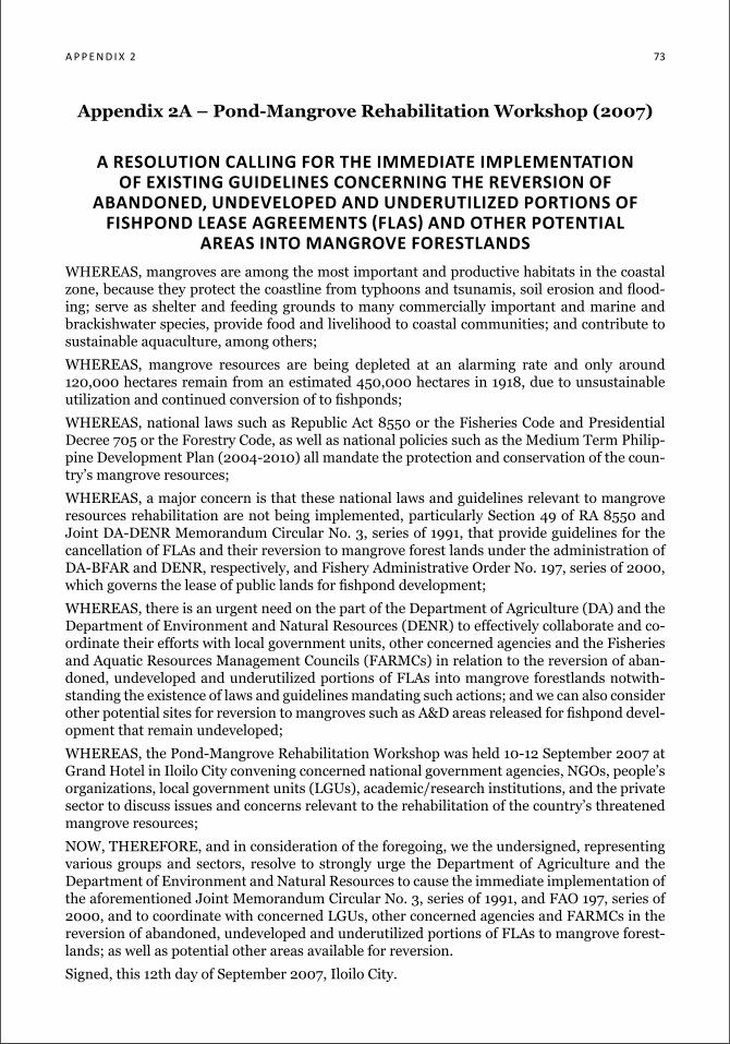
a P P e n d i x 2 73
Appendix 2A – Pond-Mangrove Rehabilitation Workshop (2007)
a resolution calling for the iMMediate iMpleMentation of existing guidelines concerning the reversion of
abandoned, undeveloped and underutiliZed portions of FiShPond leaSe agreeMenTS (FlaS) and oTher PoTenTial
areas into Mangrove forestlandsWHEREAS, mangroves are among the most important and productive habitats in the coastal zone, because they protect the coastline from typhoons and tsunamis, soil erosion and flood-ing; serve as shelter and feeding grounds to many commercially important and marine and brackishwater species, provide food and livelihood to coastal communities; and contribute to sustainable aquaculture, among others;
WHEREAS, mangrove resources are being depleted at an alarming rate and only around 120,000 hectares remain from an estimated 450,000 hectares in 1918, due to unsustainable utilization and continued conversion of to fishponds;
WHEREAS, national laws such as Republic Act 8550 or the Fisheries Code and Presidential Decree 705 or the Forestry Code, as well as national policies such as the Medium Term Philip-pine Development Plan (2004-2010) all mandate the protection and conservation of the coun-try’s mangrove resources;
WHEREAS, a major concern is that these national laws and guidelines relevant to mangrove resources rehabilitation are not being implemented, particularly Section 49 of RA 8550 and Joint DA-DENR Memorandum Circular No. 3, series of 1991, that provide guidelines for the cancellation of FLAs and their reversion to mangrove forest lands under the administration of DA-BFAR and DENR, respectively, and Fishery Administrative Order No. 197, series of 2000, which governs the lease of public lands for fishpond development;
WHEREAS, there is an urgent need on the part of the Department of Agriculture (DA) and the Department of Environment and Natural Resources (DENR) to effectively collaborate and co-ordinate their efforts with local government units, other concerned agencies and the Fisheries and Aquatic Resources Management Councils (FARMCs) in relation to the reversion of aban-doned, undeveloped and underutilized portions of FLAs into mangrove forestlands notwith-standing the existence of laws and guidelines mandating such actions; and we can also consider other potential sites for reversion to mangroves such as A&D areas released for fishpond devel-opment that remain undeveloped;
WHEREAS, the Pond-Mangrove Rehabilitation Workshop was held 10-12 September 2007 at Grand Hotel in Iloilo City convening concerned national government agencies, NGOs, people’s organizations, local government units (LGUs), academic/research institutions, and the private sector to discuss issues and concerns relevant to the rehabilitation of the country’s threatened mangrove resources;
NOW, THEREFORE, and in consideration of the foregoing, we the undersigned, representing various groups and sectors, resolve to strongly urge the Department of Agriculture and the Department of Environment and Natural Resources to cause the immediate implementation of the aforementioned Joint Memorandum Circular No. 3, series of 1991, and FAO 197, series of 2000, and to coordinate with concerned LGUs, other concerned agencies and FARMCs in the reversion of abandoned, undeveloped and underutilized portions of FLAs to mangrove forest-lands; as well as potential other areas available for reversion.
Signed, this 12th day of September 2007, Iloilo City.
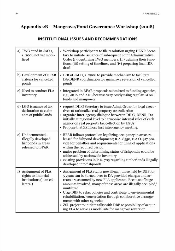
74 a P P e n d i x 2
Appendix 2B – Mangrove/Pond Governance Workshop (2008)
institutional issues and recoMMendations
a) TWG cited in JAO 1, s. 2008 not yet mobi-lized
• Workshop participants to file resolution urging DENR Secre-tary to initiate issuance of subsequent Joint Administrative Order (i) identifying TWG members; (ii) defining their func-tions, (iii) setting of timelines, and (iv) preparing final IRR draft
b) Development of BFAR criteria for cancelled ponds
• IRR of JAO 1, s. 2008 to provide mechanism to facilitate DA-DENR coordination for mangrove reversion of cancelled ponds
c) Need to conduct FLA inventory
• integrated in BFAR proposals submitted to funding agencies, e.g., JICA and ADB because very costly using regular BFAR funds and manpower
d) LGU issuance of tax declaration to claim-ants of public lands
• request DILG Secretary to issue Admi. Order for local execu-tives to rationalize real property tax collection
• organize inter-agency dialogue betweeen DILG, DENR, DA initially at regional level to harmonize internal rules of each agency on real property tax collection by LGUs.
• Propose that ZSL host first inter-agency meeting.
e) Undocumented, Illegally developed fishponds in areas released to BFAR
• BFAR follows protocol on legalizing occupancy in areas re-leased for fishpond development; R.A. 8550, F.A.O. 917 pro-vide for penalties and requirements for filing of applications within the required period
• major problem of determining status of fishponds; could be addressed by nationwide inventory
• existing provisions in P.D. 705 regarding timberlands illegally developed into fishponds
f) Assignment of FLA rights to financial institutions (loan col-lateral)
• Assignment of FLA rights now illegal; those held by DBP for 5 years can be turned over to DA provided charges and ar-rears are assumed by new FLA applicants. Because of huge amounts involved, many of these areas are illegally occupied/ unutilized
• Urge DBP to relax policies and contribute to environmental rehabilitation/ conservation through collaborative arrange-ments with other agencies
• ZSL project to initiate talks with DBP re possibility of acquir-ing FLA to serve as model site for mangrove reversion
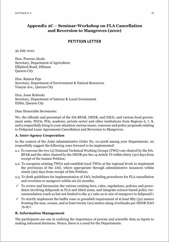
a P P e n d i x 2 75
Appendix 2C – Seminar-Workshop on FLA Cancellation and Reversion to Mangroves (2010)
petition letter
30 July 2010
Hon. Proceso AlcalaSecretary, Department of AgricultureElliptical Road, DilimanQuezon City
Hon. Ramon PajeSecretary, Department of Environment & Natural ResourcesVisayas Ave., Quezon City
Hon. Jesse RobredoSecretary, Department of Interior & Local GovernmentEDSA, Quezon City
Dear Honorable Secretaries:
We, the officials and personnel of the DA-BFAR, DENR, and DILG, and various local govern-ment units, NGOs, POs, academe, private sector and other institutions from Regions 6, 7, 8, and 9 respectfully bring to your attention various issues, concerns and policy proposals relating to Fishpond Lease Agreements Cancellation and Reversion to Mangroves.
A. Inter-Agency Cooperation
In the context of the Joint Administrative Order No. 01-2008 among your Departments, we respectfully suggest the following ways forward to be implemented:
a.1. To convene the two (2) National Technical Working Groups (TWG) one chaired by the DA-BFAR and the other chaired by the DENR per Sec.14 Article VI within thirty (30) days from receipt of the instant Petition;
a.2. To recognize existing TWGs and establish local TWGs at the regional levels to implement the provisions of the JAO, where appropriate through administrative issuances within ninety (90) days from receipt of this Petition;
a.3. To draft guidelines for implementation of JAO, including procedures for FLA cancellation and reversion to mangrove within six (6) months;
To review and harmonize the various existing laws, rules, regulations, policies and proce-dures involving fishponds in FLA and titled areas, and integrate science-based policy rec-ommendation (such as but not limited to the 4:1 ratio as to size of mangrove to fishpond)1;
To strictly implement the buffer zone or greenbelt requirement of at least fifty (50) meters fronting the seas, oceans, and at least twenty (20) meters along riverbanks per DENR DAO 76-872.
B. Information Management
The participants are one in realizing the importance of precise and scientific data as inputs to making informed decisions. Hence, there is a need for the Departments:
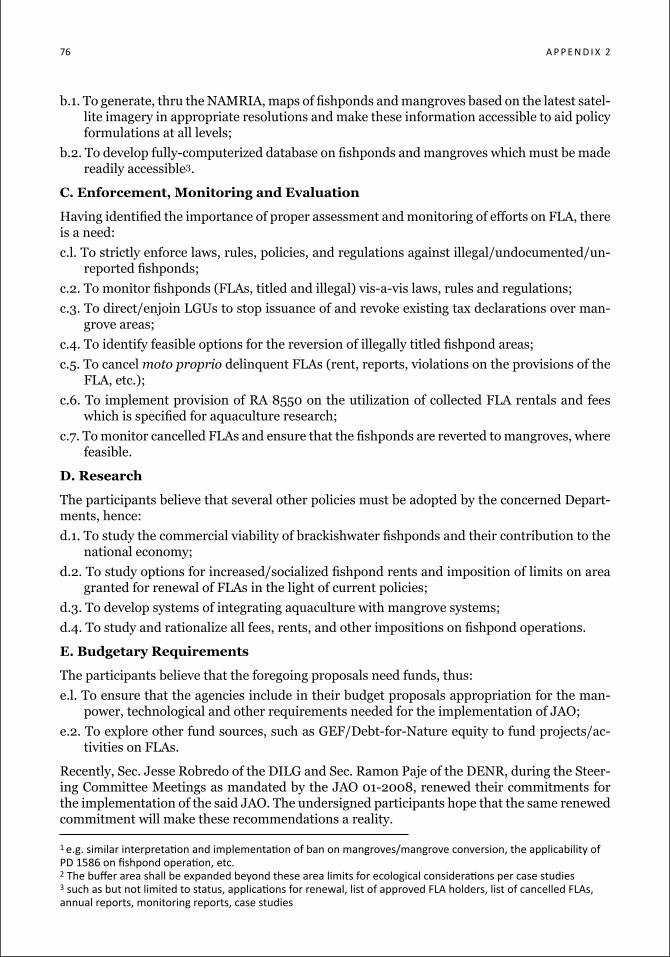
76 a P P e n d i x 2
b.1. To generate, thru the NAMRIA, maps of fishponds and mangroves based on the latest satel-lite imagery in appropriate resolutions and make these information accessible to aid policy formulations at all levels;
b.2. To develop fully-computerized database on fishponds and mangroves which must be made readily accessible3.
C. Enforcement, Monitoring and Evaluation
Having identified the importance of proper assessment and monitoring of efforts on FLA, there is a need:
c.l. To strictly enforce laws, rules, policies, and regulations against illegal/undocumented/un-reported fishponds;
c.2. To monitor fishponds (FLAs, titled and illegal) vis-a-vis laws, rules and regulations;
c.3. To direct/enjoin LGUs to stop issuance of and revoke existing tax declarations over man-grove areas;
c.4. To identify feasible options for the reversion of illegally titled fishpond areas;
c.5. To cancel moto proprio delinquent FLAs (rent, reports, violations on the provisions of the FLA, etc.);
c.6. To implement provision of RA 8550 on the utilization of collected FLA rentals and fees which is specified for aquaculture research;
c.7. To monitor cancelled FLAs and ensure that the fishponds are reverted to mangroves, where feasible.
D. Research
The participants believe that several other policies must be adopted by the concerned Depart-ments, hence:
d.1. To study the commercial viability of brackishwater fishponds and their contribution to the national economy;
d.2. To study options for increased/socialized fishpond rents and imposition of limits on area granted for renewal of FLAs in the light of current policies;
d.3. To develop systems of integrating aquaculture with mangrove systems;
d.4. To study and rationalize all fees, rents, and other impositions on fishpond operations.
E. Budgetary Requirements
The participants believe that the foregoing proposals need funds, thus:
e.l. To ensure that the agencies include in their budget proposals appropriation for the man-power, technological and other requirements needed for the implementation of JAO;
e.2. To explore other fund sources, such as GEF/Debt-for-Nature equity to fund projects/ac-tivities on FLAs.
Recently, Sec. Jesse Robredo of the DILG and Sec. Ramon Paje of the DENR, during the Steer-ing Committee Meetings as mandated by the JAO 01-2008, renewed their commitments for the implementation of the said JAO. The undersigned participants hope that the same renewed commitment will make these recommendations a reality.
1 e.g. similar interpretation and implementation of ban on mangroves/mangrove conversion, the applicability of Pd 1586 on fishpond operation, etc. 2 the buffer area shall be expanded beyond these area limits for ecological considerations per case studies 3 such as but not limited to status, applications for renewal, list of approved fla holders, list of cancelled flas, annual reports, monitoring reports, case studies
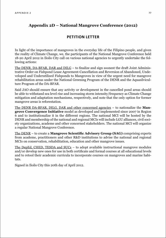
a P P e n d i x 2 77
Appendix 2D – National Mangrove Conference (2012)
petition letter
In light of the importance of mangroves in the everyday life of the Filipino people, and given the reality of Climate Change, we, the participants of the National Mangrove Conference held 18-20 April 2012 in Iloilo City call on various national agencies to urgently undertake the fol-lowing actions:
The DENR, DA-BFAR, DAR and DILG – to finalize and sign soonest the draft Joint Adminis-trative Order on Fishpond Lease Agreement-Cancellation and Reversion of Abandoned, Unde-veloped and Underutilized Fishponds to Mangroves in view of the urgent need for mangrove rehabilitation areas under the National Greening Program of the DENR and the Aquasilvicul-ture Program of the DA-BFAR.
Said JAO should ensure that any activity or development in the cancelled pond areas should be able to withstand sea level rise and increasing storm intensity/frequency as Climate Change mitigation and adaptation mechanisms, respectively, and note that the only option for former mangrove areas is reforestation.
The DENR DA-BFAR, DILG, DAR and other concerned agencies – to nationalize the Man-grove Convergence Initiative model as developed and implemented since 2007 in Region 6 and to institutionalize it in the different regions. The national MCI will be hosted by the DENR and membership of the national and regional MCIs will include LGU alliances, civil soci-ety organizations, academe and other concerned stakeholders. The national MCI will organize a regular National Mangrove Conference.
The DENR – to create a Mangrove Scientific Advisory Group (SAG) comprising experts from academe, practitioners and other R&D institutions to advise the national and regional MCIs on conservation, rehabilitation, education and other mangrove issues.
The DepEd, CHED, TESDA and SUCs – to adopt available instructional mangrove modules and/or develop new ones for use in both certificate and formal courses at all educational levels and to retool their academic curricula to incorporate courses on mangroves and marine habi-tats.
Signed in Iloilo City this 20th day of April 2012.
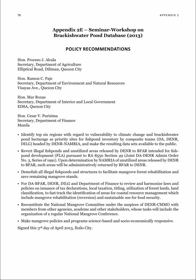
78 a P P e n d i x 2
Appendix 2E – Seminar-Workshop on Brackishwater Pond Database (2013)
policy recoMMendations
Hon. Proceso J. AlcalaSecretary, Department of AgricultureElliptical Road, Diliman, Quezon City
Hon. Ramon C. PajeSecretary, Department of Environment and Natural ResourcesVisayas Ave., Quezon City
Hon. Mar RoxasSecretary, Department of Interior and Local GovernmentEDSA, Quezon City
Hon. Cesar V. PurisimaSecretary, Department of FinanceManila
• Identify top six regions with regard to vulnerability to climate change and brackishwater pond hectarage as priority sites for fishpond inventory by composite teams (DA, DENR, DILG) headed by DENR-NAMRIA, and make the resulting data sets available to the public.
• Revert illegal fishponds and unutilized areas released by DENR to BFAR intended for fish-pond development (FLA) pursuant to RA 8550 Section 49 (Joint DA-DENR Admin Order No. 3, Series of 1991). Upon determination by NAMRIA of unutilized areas released by DENR to BFAR, such areas will be administratively returned by BFAR to DENR.
• Demolish all illegal fishponds and structures to facilitate mangrove forest rehabilitation and save remaining mangrove stands.
• For DA-BFAR, DENR, DILG and Department of Finance to review and harmonize laws and policies on issuance of tax declarations, local taxation, titling, utilization of forest lands, land classification, to fast track the identification of areas for coastal resource management which include mangrove rehabilitation (reversion) and sustainable use for food security.
• Reconstitute the National Mangrove Committee under the auspices of DENR-CMMO with members from other agencies, academe and other stakeholders, whose tasks will include the organization of a regular National Mangrove Conference.
• Make mangrove policies and programs science-based and socio-economically responsive.
Signed this 3rd day of April 2013, Iloilo City.
a P P e n d i x 3 79
Appendix 3 – BFAR FAO 197-1
republic of the Philippines department of agriculture
bureau of fisheries and aquatic resources 3rd floor, Pca Building, elliptical road, diliman, Quezon city
tel. nos. 426-6532, 455-28-87, 455-1049 fax nos. 929-8074, 426-6532
FISHERIES ADMINISTRATIVE) ORDER NO. 197-1: Series of 2012 )
SuBJect: revised rules and regulations governing the lease of PubliC landS For FiShPond and Mangrove-Friendly aquaCulTure
Pursuant to Section 16, Article II of the 1987 Constitution, Sections 3, 6, 12, 13, 45, 46, 50, 55, 57, 65, 103 (b) and 107 of Republic Act 8550, Republic Act 8289 as amended by Republic Act 9501 and Executive Order 26 series of 2011, the following rules and regulations governing the lease of public lands for fishpond and mangrove-friendly aquaculture are hereby promulgated for the guidance of all concerned:
1. WORDS AND TERMS DEFINED
SECTION 1. Definitions. – For purposes of this Order, the words and terms herein shall be construed as follows:
1.1 Abandoned fishpond – refers to public land released for fishpond development where there is no occupation, possession or operational activity by the lessee or any of his or her law-ful representative as manifested by any of, but not limited to, the following conditions: (1) failure by the lessee to submit to the Bureau within ten (10) days after six months from the approval of the lease the required initial report under oath relative to the fishpond develop-ment, operation and production, duly verified by the concerned Regional Director or his or her authorized representative; (2) subleasing; or, (3) where there is absence of clear indica-tion of fish production operations in the area;
1.2 Aquasilviculture Stewardship Contract (ASC) – a contract entered into by and between the Secretary and qualified fisherfolk cooperatives/associations and micro, small and medium enterprises for the use of public land for mangrove-friendly aquaculture;
1.3 Areas released for fishpond development – portions of public land transferred by the DENR to the Bureau for fishpond development by virtue of the following: (a) certifications issued by the Director of the Bureau of Forest Development (BFD) now the Forest Management Bureau (FMB), for releases made prior to the issuance of Presidential Decree 705; (b) BFD/FMB Administrative Orders; and, (c) individual releases of alienable and disposable areas under the Bureau of Lands, now the Land Management Bureau, made prior to the effectiv-ity of Republic Act 8550;
1.4 Authorized representatives – include personnel of the Bureau or Department duly autho-rized by the Regional Director, the Director, the Undersecretary for Fisheries or the Secre-tary as the case may be;
80 a P P e n d i x 3
1.5 Bureau – Bureau of Fisheries and Aquatic Resources;
1.6 Commercial-scale production – aquaculture production of fish in the required volume or its equivalent per hectare per year;
1.7 Department – Department of Agriculture;
1.8 DENR – Department of Environment and Natural Resources;
1.9 Developed fishpond – refers to public land released for fishpond development where the area is enclosed by dikes with functional water control structures and not vegetated with mangrove species;
1.10 Director – Director of the Bureau;
1.11 Environmental Compliance Certificate – a permit issued by the President or his duly au-thorized representative certifying that the new fishpond development will not bring about unacceptable environmental impact and that the proponent has complied with the require-ments of Presidential Decree 1586 and its implementing rules and regulations;
1.12 Fish – includes not only finfish but also mollusks, crustaceans, echinoderms, marine mam-mals, and all other species of the aquatic flora and fauna;
1.13 Fisherfolk – people directly or personally and physically engaged in taking and/or cultur-ing and processing fishery and/or aquatic resources;
1.14 Fisherfolk cooperative – a duly registered association of fisherfolk with a common bond of interest, who have voluntarily joined together to achieve a lawful common social or eco-nomic end, making equitable contribution to the capital requirement and accepting a fair share of the risks and benefits of the undertakings in accordance with universally accepted cooperative principles;
1.15 Fisherfolk organization – an organized group, association, federation, alliance or an insti-tution of fisherfolk which has at least fifteen (15) members, a set of officers, a constitution and by-laws, an organizational structure and a program of action;
1.16 Fishpond – a land-based facility enclosed with earthen, stone or concrete material to im-pound water for the growing of fish;
1.17 Fishpond Lease Agreement (FLA) – an agreement entered into by and between the Secre-tary and a qualified applicant for the use of developed public fishpond areas;
1.18 Foreshore land – a string of land margining a body of water, the part of a seashore between the low-water line usually at the seaward margin of a low tide terrace and the upper limit of wave wash at high tide usually marked by a beach scarp or berm;
1.19 Fully developed fishpond – refers to public land released for fishpond development where the area is clean, leveled and enclosed with dikes at least one foot higher than the highest flood water level in the locality and strong enough to resist water pressure at the highest flood tide, and consists of at least a nursery pond, a transition pond, a rearing pond, or a combination of any or all of said classes of ponds and a functional water control system and producing in a commercial scale;
1.20 Mangroves/tidal swamps/marshes – a community of intertidal plants including all spe-cies of trees, shrubs, vines and herbs found on coasts, swamps, or border of swamps;
1.21 Mangrove-friendly aquaculture – aquaculture method having minimal adverse impact on the mangrove environment, which may include but is not limited to culture of fish in pens,
a P P e n d i x 3 81
ponds or rafts integrated with mangrove trees inside the forest itself (aquasilvicuture) or harvesting/gleaning of fishery or aquatic resources inside the mangrove forest (silvofisher-ies);
1.22 MFARMC – Municipal Fisheries and Aquatic Resources Management Council;
1.23 Micro, Small and Medium Enterprise (MSME) – any business activity or enterprise en-gaged in industry, agribusiness and/or services, whether single proprietorship, coopera-tive, partnership or corporation whose total assets, inclusive of those arising from loans but exclusive of the land on which the particular business entity’s office, plant and equipment are situated, must have value falling under the following categories:
micro: not more than P3,000,000 small: P3,000,001 – 15,000,000 medium: P15,000,001 – P1,000,000,000,
which value is subject to review and adjustments by the Micro, Small and Medium Enter-prises Development (MSMED) Council;
1.24 Occupied – actual or constructive possession over the fishpond area;
1.25 Permanent improvement – improvement introduced in the fishpond area which cannot be separated/removed therefrom without causing damage thereto;
1.26. Person – natural or juridical entities such as individuals, associations, partnerships, co-operatives or corporations;
1.27 Regional Director – Regional Director of the Bureau;
1.28 Regional Office – Regional Office of the Bureau;
1.29 Resource rent – the difference between the value of the products produced from harvest-ing a publicly owned resource less the cost of producing it, where cost includes the normal return to capital and normal return to labor;
1.30 Secretary – Secretary of the Department of Agriculture
1.31. Suitable for fishpond purposes – meeting all accepted criteria on elevation, soil type, soil depth, topography and water supply required for successful fishpond development;
1.32 Temporary improvement – improvement introduced in the fishpond area which can be removed/separated therefrom without causing damage thereto or diminish the usefulness thereof;
1.33 Unoccupied – not occupied by any person, or is occupied by a person disqualified to ac-quire or enter upon it, or by a person who, being qualified to occupy or use it, refuses or fails to exercise his preferential right thereto;
1.34 Underutilized fishpond – refers to public land released for fishpond development where the fishpond area or portion thereof is not producing in commercial scale within three (3) years from the approval of the ASC or FLA, or not fully developed and producing in com-mercial scale within five (5) years as reflected in either (1) the submitted annual report on fishpond development, operation and production, under oath by the ASC holder or lessee and duly verified by the concerned Regional Office; or (2) as deduced from the information supplied in the Reports on Inspection and Verification, submitted by authorized represen-tatives and duly endorsed by the Regional Director concerned, evidencing that such por-tion or the whole fishpond area is not producing on a commercial scale;
82 a P P e n d i x 3
1.35 Undeveloped fishpond area – refers to public land released for fishpond development where the fishpond area is not enclosed by dikes; or enclosed by dikes but without func-tional water control structures; or enclosed by dikes with functional water control struc-tures but the water level required for production on a commercial scale cannot be main-tained either by high tides or by pumping; or a larger area enclosed only with a simple perimeter dike which has not been subdivided, which may or may not be vegetated with mangrove species;
1.36 Vegetated with mangrove species – an intertidal area of one (1) hectare or more with at least ten (10) percent mangrove crown cover in each hectare (i.e., when the sun is directly overhead at high noon, the shadows cast by mangrove species cover at least ten [10] per-cent of the area).
II. PERMITS, CONTRACTS AND LEASES
SECTION 2. Use of areas released for fishpond development. – No person shall occupy or use any portion of areas released for fishpond development as defined, without first securing a per-mit, contract or lease in accordance with the provisions of this Order.
SECTION 3. Permits, Contracts and Leases. –
(a) Gratuitous Permit – A Gratuitous Permit (GP) for portions of areas released for fishpond development may be granted by the Secretary upon the recommendation of the Director to any branch of government, academic, scientific or research institution, for scientific, research, educational or experimental breeding purposes.
(b) Stewardship Contract – An Aquaculture Stewardship Contract (ASC) may be granted for mangrove-friendly aquaculture by the Secretary upon the recommendation of the Director to fisherfolk cooperative or association as well as MSME over areas released for fishpond development.
(c) Lease Agreement – A Fishpond Lease Agreement (FLA) for fishpond operations may be granted by the Secretary upon the recommendation of the Director to qualified applicants over areas released for fishpond development that have already been developed into fish-ponds.
SECTION 4. Area that may be granted. –
a) An area not exceeding fifty (50) hectares may be granted to a fisherfolk cooperative/asso-ciation or MSME through an ASC;
b) An area not exceeding twenty-five (25) hectares may be granted to an individual or hus-band and wife living together through an FLA. A person who is already a holder of FLA over an area as provided herein shall be precluded from acquiring any right or interest in another permit, contract or lease issued or granted to any corporation, association or part-nership, even if his interest is that of a stockholder or member thereof;
c) An area not exceeding twenty-five (25) hectares subject to availability, may be granted through a gratuitous permit, to any branch of the government, academic, scientific or re-search institution that will engage in aquaculture for scientific, research, educational or experimental breeding purposes;
d) An area not exceeding fifty (50) hectares may be granted through an FLA to a corporation duly registered with the Securities and Exchange Commission;
a P P e n d i x 3 83
e) The provisions of the preceding paragraphs notwithstanding, the Secretary may, in his dis-cretion, increase the area that may be granted for reason of public interest, taking into con-sideration the financial capacity and/or qualification of the applicant and the importance of the project or industry for which the area is to be used.
SECTION 5. Persons who may apply for lease. –
A. The following persons shall have preference in applying for an Aquasilviculture Steward-ship Contract (ASC):
(a) Fisherfolk cooperative/association organized or registered under the laws of the Philip-pines, provided that:(1) at least fifty (50) percent of its members are registered voters of the municipality
where the fishpond area being applied for is located;(2) the cooperative/association has secured endorsement from the MFARMC;(3) the cooperative/association has financial capability and an existing financial man-
agement system;(4) the cooperative/association has been existing for at least one (1) year; and,(5) the technical staff of the cooperative/association has executed an affidavit stating
willingness to undergo training on and to engage in mangrove-friendly aquacul-ture.
(b) MSMEs duly organized or registered under the laws of the Philippines, provided that:(1) the principal or proprietor and at least fifty (50) percent of the paid workers are reg-
istered voters of the province where the fishpond area being applied for is located;(2) they present a duly audited and notarized financial statement;(3) they have been endorsed by the MFARMC; and,(4) the technical staff of the MSME has executed an affidavit stating willingness to un-
dergo training on and to engage in mangrove-friendly aquaculture.
B. In the absence or non-qualification of fisherfolk cooperative/association or MSME appli-cants, a citizen of the Philippines may apply for ASC provided, he or she is at least twenty-one years of age, a registered voter of the province where the fishpond area being applied for is located, has secured endorsement from the MFARMC and has executed an affidavit expressing his or her willingness to undergo training on and to engage in mangrove-friend-ly aquaculture.
C. The following persons may apply for FLA over developed public fishpond areas:(a) Citizens of the Philippines who are at least twenty-one years of age;(b) Corporations duly incorporated and registered under the laws of the Philippines at least
sixty per centum (60%) of the capital stock or interest of which belongs to citizens of the Philippines.
D. Any branch of the government or any academic, scientific or research institution that will engage in aquaculture for scientific, research, educational or experimental breeding pur-poses may apply for a gratuitous permit over public lands released to BFAR for aquaculture purposes.
SECTION 6. Period of Permits. Contracts and Leases. – A Gratuitous Permit shall be valid for a period of five (5) years renewable for another five (5) years, and for as long as the area is needed by the permittee, subject to the submission of an annual report pertaining to the approved use of the area.
The ASC shall be for a period of ten (10) years, renewable for another ten (10) years.
84 a P P e n d i x 3
The FLA shall be for a period of twenty-five (25) years, renewable for another twenty-five years but not to exceed fifty (50) years, Provided, that transfers shall only be allowed within the fifty-year period, Provided, further, that there shall be no right of renewal after fifty (50) years by the lessee, transferee or their legal heirs.
SECTION 7. General conditions under which permits. contracts and leases are issued. – Every permit, contract or lease shall be governed by the provisions of this Order, as well as by those which may hereafter be promulgated, especially by the following terms and conditions:
(a) Power of Congress. – The permits, contracts or leases limit in no way the right of Congress to impose such terms and conditions as it may consider necessary for public interest;
(b) Permittee, contracting party or lessee shall comply with the law, rules and regulations. – The permittee, contracting party or lessee shall subject himself, herself or itself uncon-ditionally to all laws, rules and regulations now existing and to those that may hereafter be promulgated governing fisheries;
(c) Legal status of land. – The area granted is public forest land to the best knowledge and belief of the Director or the Secretary;
(d) No title acquired. – A permittee, contracting party or lessee shall have no right to a title or claim of any sort whatsoever on the land covered by the permit, contract or lease. No such land shall be deemed to be occupied within the meaning of the Public Land Act. Areas re-leased for fishpond development, which have been titled during the lifetime of the GP, ASC or FLA, shall be referred to the Office of the Solicitor General for reversion to the public domain;
(e) Adjudication of area and damage. – The Secretary or the Director shall not be responsible for any loss occasioned by the adjudication of the area in favor of any claimant by the com-petent court and the permittee, contracting party or lessee shall have no right to claim for any damage arising from such decision;
(f) Statements in application as part of the conditions of the permit contract or lease. – Any or all of the statements made in the application shall be considered as essential conditions and part of the permit, contract or lease granted. Any false statement in the application or material omission of facts or alteration, change, modification of any or all of the terms and conditions therein shall ipso facto cause the cancellation of the permit, contract or lease;
(g) Surface right. – The permit, contract or lease issued under this Order shall vest in the holder thereof a surface right only to the land covered thereby; and that the permittee, con-tracting party or lessee shall have no right to utilize or remove any timber or other forest products, stones, or earth therefrom without authority from proper officials;
(h) Exclusive privilege. – No license or permit to exploit any other resources within the area granted detrimental to the interest of the permittee, contracting party or lessee shall be granted to other persons;
(i) Free access to area. – The Secretary, the Undersecretary for Fisheries, the Director and their authorized representatives shall have free access at all times to the land under permit, contract or lease;
(j) Free navigation. – The permittee, contracting party or lessee shall not obstruct or interfere with the free navigation in any public stream, lakes or bays adjoining or flowing through the area, as well as with the defined migration paths of migratory fish;
a P P e n d i x 3 85
(k) Rentals. – Annual rentals shall be set at levels that reflect resource rent accruing from the utilization of resources and shall be determined by the Secretary through the Director in consultation with stakeholders and the National Fisheries and Aquatic Resources Manage-ment Council (NFARMC) based on a scientific study to be conducted every five (5) years;
(l) Disposition of improvements. –
(1) The permittee, contracting party or lessee shall have no right by virtue of the permit, contract or lease to claim for reimbursement for the expenses incurred for improve-ments of whatever kind, which he or she may have introduced on the land;
(2) Upon the expiration or cancellation of the permit, contract or lease, or the rejection of an application for permit, contract or lease, the improvements existing thereon shall become the property of the government.
III. APPLICATIONS
SECTION 8. Form and contents of application. – All applications for permit, contract or lease shall be submitted on a prescribed form. In case the applicant is a corporation, cooperative, MSME, association or partnership, the application shall be accompanied by documents con-sisting of the articles of incorporation/cooperation, by-laws, and certificate of registration and such other documents showing that the applicant is qualified under this Order.
SECTION 9. Place of filing. – An application shall be filed with the Regional or Provincial Office where the area is located.
SECTION 10. Application fee. – A non-refundable application fee of Two Thousand (P2,000.00) pesos shall be paid to the Regional Office or Provincial Office upon the filing of the application for ASC or FLA.
SECTION 11. When application is considered filed. – An application for permit, contract or lease shall be considered filed on the date and time the original thereof including the complete set of initial requirements are actually received in the Regional or Provincial Office where the area is located. Application with incomplete initial requirements shall be rejected outright and is not considered filed.
The applicant shall not cause any transfer covering all or portion of the area applied for during the course of the application process, violation of which shall cause automatic rejection of his or her application and forfeiture of all improvements introduced therein.
SECTION 12. Recording of applications. – All accepted applications for ASC or FLA shall be given serial numbers and shall be duly recorded in the registry book provided for the purpose.
SECTION 13. Priority right of application. – In determining the priority of applications, the following rules shall be observed:
a) When two or more applications are filed for the same area, the first applicant shall have the right of preference thereto;
b) Any Filipino citizen, with preference, primarily to qualified fisherfolk cooperatives/associa-tions as well as MSMEs shall have priority right in the application over areas, the lease over which has expired or has been cancelled or terminated for cause;
c) If applications are filed by two or more qualified fisherfolk cooperatives or associations or MSMEs for the same area and on the same date, the FLA or ASC shall be raffled off among the applicants.
86 a P P e n d i x 3
SECTION 14. Initial requirements in the filing of application for contract or lease over areas released for fishpond development. – The initial requirements for the filing of an application for ASC or FLA are as follows:
a) Four (4) copies of the sketch plan of the area released for fishpond purposes with its techni-cal description as extracted from the Land Classification Map of the Forest Management Bureau;
b) In case of a juridical person, two (2) certified true copies of By-laws and Articles of Incor-poration, Cooperation, Association or Partnership duly approved by government agencies concerned, the primary purpose of which is to engage in fishery/aquaculture business;
c) A Certificate of Bank Deposit issued by any Banking Institution showing that the applicant has a current or checking account and has capital in cash of P5,000.00 per hectare or frac-tion thereof and the bank statements of said account for the preceding six (6) months;
d) An affidavit declaring that the initial capital deposited in the Bank shall be used exclusively for the development of the area;
e) Notarized affidavit of adherence to Good Aquaculture Practices in the form prescribed in Annex A hereof;
f) Proof of compliance with Section 5A (a) or 5A (b), whenever applicable.
SECTION 15. Requirements in the filing of application for gratuitous permit. – The require-ments in the filing of application for gratuitous permit are as follows:
a) Project profile which states:i) The general and specific objectives of the project;ii) A brief description of the project; and,iii) The methodology of project implementation, which includes: names of personnel in-
volved and percentage of time allocated to the project; schedule of implementation, funding requirement and sources both local and foreign; target beneficiaries; and, monitoring and evaluation scheme.
b) Sketch plan of the area.
SECTION 16. Final requirements for the application of contract or lease. – A qualified appli-cant whose application form and initial requirements have been accepted shall submit as final requirements the following:
a) Twelve (12) copies of the survey plan of the area duly approved by the Director of Lands or Regional Director of Lands, or if under cadastral survey, the same shall be certified by the Bureau of Lands;
b) Duly accomplished FLA or ASC acknowledged before a Notary Public;
c) Certifications issued by the Regional Director and the Regional Trial Court in the judicial district where the area applied for is located to the effect that the same is not involved in any pending administrative and judicial case, respectively;
d) Payment of cash bond deposit and initial rental;
e) Certification issued by the Regional Director to the effect that the area applied for is not sub-leased to any other person/s;
f) Environmental Compliance Certificate or Certificate of Non-Coverage from the DENR as the case may be; and,
a P P e n d i x 3 87
g) Proof of updated remittances to the Social Security System covering contributions of perma-nent workers employed in the fishpond, whenever applicable.
SECTION 17. Requirements for the Renewal of the ASC or FLA. – The requirements for the renewal of the ASC or FLA are as follows:
a) Payment of application fee of P2,000;
b) Payment of cash bond and initial rental;
c) Certification issued by the Regional Trial Court in the judicial district where the area applied for is located to the effect that the same is not involved in any pending judicial case;
d) Photocopy of the approved survey plan on record if the area remains unchanged as indicated therein;
e) Inspection report endorsed by the BFAR Regional Director validating that:1. the area is developed and the applicant has adhered to Good Aquaculture Practices;2. the area is not involved in any pending administrative case;3. the lessee has no unpaid rentals and surcharges;4. the area remains unchanged as indicated in the approved survey plan on record.
f) A new survey plan, should there be changes in the area.
SECTION 18. Conditions on the assignment/transfer of ASC or FLA rights and interests. – The assignment or transfer of rights under ASC or FLA may be allowed under the following condi-tions:
a) The assignor or transferor has held the contract or lease for a period of not less than five (5) years from the approval thereof;
b) The fishpond area of the ASC or FLA subject of the proposed assignment or transfer has been developed;
c) The assignor/transferor has not violated any provisions of the fishery laws, rules and regula-tions governing areas released for fishpond development including the terms and condi-tions of the contract or lease;
d) The assignee/transferee is qualified to hold the contract or lease pursuant to the provisions of this Order;
e) The area subject of the assignment/transfer is not involved in any administrative or judicial case; and,
f) The transferee shall enjoy only the privilege to hold the contract or lease for the unexpired period and shall assume the obligations of the transferor relative to the said contract or lease. The transferee of a Fishpond Lease Agreement (FLA) may apply for a 25-year lease renewal, if the transferor has never exercised such option for renewal, Provided, that the combined period of the FLA for both transferor and transferee shall not exceed fifty years, Provided, further, that the transferee or his or her legal heirs shall have no right of renewal after the fifty-year period of the FLA.
SECTION 19. Requirements on assignment/transfer of ASC or FLA rights. – The assignee/transferee shall submit the following requirements;
a) The prior written approval of the LESSOR;
b) An application form duly accomplished;
88 a P P e n d i x 3
c) Original copy of the Deed of Assignment or Transfer and Assumption of Obligations;
d) Certified true copies of original official receipts of updated payment of rentals;
e) Payment of assignment or transfer fee in the amount of one hundred pesos (P100) per hect-are or fraction thereof;
f) Payment of application fee of P2,000.00;
g) Posting of required cash bond deposit;
h) Latest report of improvements verified by the Regional Director or his authorized represen-tative, showing that the fishpond area of the ASC or FLA subject of the proposed assign-ment or transfer has been developed;
i) Twelve (12) copies of the survey plan of the area under his/her name duly approved by the Director of Lands or Regional Director of Lands;
j) Contract or lease form duly accomplished and acknowledged before a Notary Public;
k) Certification issued by the BFAR Regional Director and Regional Trial Court in the judicial district where the area applied for is located to the effect that the same is not involved in any pending administrative and judicial case, respectively;
l) Affidavit and certification executed and issued by the applicant and BFAR Regional Director respectively, to the effect that the area applied for is not subleased to any person/s; and,
m) Notarized affidavit of adherence to Good Aquaculture Practices.
SECTION 20. Grounds for the rejection of application for contract or lease. – An application for contract or lease or an application for renewal of contract or lease shall be rejected on any of the following grounds:
a) Lack/loss of interest of the applicant;
b) Applicant is not qualified;
c) Incomplete initial requirements;
d) Death of the individual applicant;
e) Dissolution of juridical person;
f) Fraudulent, false or misleading statements or information in the application;
g) Occupying or introducing improvements in the area applied for without an ASC or FLA;
h) Failure to comply with all the requirements stated in Section 16 or Section 17 in case of renewal, or with Sections 18 and 19 hereof in case of assignment or transfer, within six (6) months from receipt of the Notice of Compliance, Provided, that if the nature of non-compliance is due to inaction or delay of concerned government agencies, the application should not be rejected; and,
i) When public interest so requires.
IV. FEES, RENTALS AND BONDS
SECTION 21. Rentals. when due and payable. – Upon the effectivity of this Order, the annual rentals shall be due and payable to the BFAR at the rate prescribed below:
a P P e n d i x 3 89
For the first year starting from January 1, 2013 until December 31, 2013, the annual rental for the fishpond area shall be at the rate of one thousand pesos (P1,000.00) per hectare or a frac-tion thereof; for the second year, the annual rental shall be at the rate of one thousand one hun-dred pesos (P1,100.00) per hectare or a fraction thereof; for the third year, the annual rental shall be at the rate of one thousand two hundred pesos (P1,200.00) per hectare or a fraction thereof; for the fourth year, the annual rental shall be at the rate of one thousand three hundred pesos (P1,300.00) per hectare or a fraction thereof; for the fifth year, the annual rental shall be at the rate of one thousand four hundred pesos (P1,400.00) per hectare or a fraction thereof; for the sixth year and every year thereafter unless increased based on results of resource rent studies, the annual rental shall be at the rate of one thousand five hundred pesos (P1,500.00) per hectare or a fraction thereof.
The annual rental for the area allocated for mangroves or silviculture shall be at the rate of five hundred pesos (P500.00) per hectare or a fraction thereof.
Scientific studies on resource rent for FLA and ASC areas shall be conducted on the sixth (6th) year upon the approval of this Order, and every five (5) years thereafter, the results of which shall be the basis for new rental rates.
The rental must be paid to the BFAR Central Office or Regional Office where the area is located not later than the last working day of the month of February of each year.
The rental may be paid in cash or by postal money order. Check payments shall be accepted subject to Article 3, Sections 76 and 77, Volume 1 of the Government Accounting and Audit Manual. Post dated checks may be accepted provided: (1) the checks are from a current account belonging to the lessee or contracting party; (2) the date of the check is on or before the due date of the account being paid for; and, (3) only acknowledgement receipts will be given to the payor, with Official Receipt to be given only upon clearing of the checks on due date.
SECTION 22. Remittance of Rentals. – Rentals from FLAs and ASCs shall accrue to a fund other than the General Fund to be remitted to the National Fisheries Research and Develop-ment Institute and other qualified research institutions to be used for aquaculture research development pursuant to Section 46 (c) of Republic Act 8550.
SECTION 23. Surcharges for default of payment of rentals. – Non-payment of annual rental when it becomes due and payable shall be subject to a surcharge in accordance with the follow-ing schedules:
Rentals paid from March 1 to March 31 5% Rental paid from April 1 to June 30 10% Rental paid from July 1 to December 31 15% Rental paid after one (1) year 20%
The ASC or FLA holder who fully pays the annual rental for the following year, within Decem-ber of the current year shall be given a ten (10) percent discount on the annual rental by way of incentive.
SECTION 24. Cash Bond Deposit. – Before any contract or lease is issued, as a guaranty of good faith in filing the application and for the satisfactory compliance with existing fishery laws, rules and regulations promulgated thereunder and of the terms and conditions of the contract or lease, the applicant shall be required to deposit a cash bond with the Bureau or its Regional Offices. The cash bond shall be at the rate of five hundred (P500) pesos per hectare or fraction thereof: Provided, however, that after three (3) years from the approval of the FLA or ASC and the LESSEE shall have fully developed the area and made it producing in commercial scale or the CONTRACTING PARTY shall have utilized the area for mangrove-friendly aquaculture and
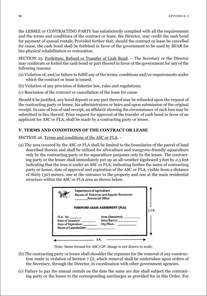
90 a P P e n d i x 3
the LESSEE or CONTRACTING PARTY has satisfactorily complied with all the requirements and the terms and conditions of the contract or lease, the Director, may credit the cash bond for payment of annual rentals, Provided further that, should the contract or lease be cancelled for cause, the cash bond shall be forfeited in favor of the government to be used by BFAR for bio-physical rehabilitation or restoration.
SECTION 25. Forfeiture, Refund or Transfer of Cash Bond. – The Secretary or the Director may confiscate or forfeit the cash bond or part thereof in favor of the government for any of the following reasons:
(a) Violation of, and/or failure to fulfill any of the terms, conditions and/or requirements under which the contract or lease is issued;
(b) Violation of any provision of fisheries law, rules and regulations;
(c) Rescission of the contract or cancellation of the lease for cause.
Should it be justified, any bond deposit or any part thereof may be refunded upon the request of the contracting party or lessee, his administrators or heirs and upon submission of the original receipt. In case of loss of said receipt, an affidavit showing the circumstance of such loss may be submitted in lieu thereof. Prior request for approval of the transfer of cash bond in favor of an applicant for ASC or FLA, shall be made by a contracting party or lessee.
V. TERMS AND CONDITIONS OF THE CONTRACT OR LEASE
SECTION 26. Terms and conditions of the ASC or FLA. –
(a) The area covered by the ASC or FLA shall be limited to the boundaries of the parcel of land described therein and shall be utilized for silviculture and mangrove-friendly aquaculture only by the contracting party or for aquaculture purposes only by the lessee. The contract-ing party or the lessee shall immediately put up an all-weather signboard 3 feet by 2.5 feet indicating that the area is under an ASC or FLA; indicating further the name of contracting party or lessee, date of approval and expiration of the ASC or FLA, visible from a distance of thirty (30) meters, one at the entrance to the property and one at the main residential structure within the ASC or FLA area as shown below.
Note: Same format for ASC/GP. Image is not drawn to scale.
(b) The contracting party or lessee shall shoulder the expenses for the removal of any construc-tion made in violation of Section 7 (j), which removal shall be undertaken upon orders of the Secretary, through the Director, in coordination with other government agencies.
(c) Failure to pay the annual rentals on the date the same are due shall subject the contract-ing party or the lessee to the corresponding surcharges as provided for in this Order. For
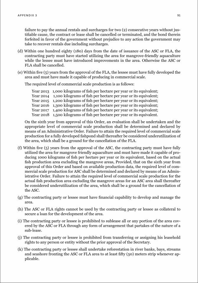
a P P e n d i x 3 91
failure to pay the annual rentals and surcharges for two (2) consecutive years without jus-tifiable cause, the contract or lease shall be cancelled or terminated, and the bond therein forfeited in favor of the government without prejudice to any action the government may take to recover rentals due including surcharges.
(d) Within one hundred eighty (180) days from the date of issuance of the ASC or FLA, the contracting party must have started utilizing the area for mangrove-friendly aquaculture while the lessee must have introduced improvements in the area. Otherwise the ASC or FLA shall be cancelled.
(e) Within five (5) years from the approval of the FLA, the lessee must have fully developed the area and must have made it capable of producing in commercial scale.
The required level of commercial scale production is as follows:
Year 2013 1,000 kilograms of fish per hectare per year or its equivalent; Year 2014 1,100 kilograms of fish per hectare per year or its equivalent; Year 2015 1,200 kilograms of fish per hectare per year or its equivalent; Year 2016 1,300 kilograms of fish per hectare per year or its equivalent; Year 2017 1,400 kilograms of fish per hectare per year or its equivalent; Year 2018 1,500 kilograms of fish per hectare per year or its equivalent.
On the sixth year from approval of this Order, an evaluation shall be undertaken and the appropriate level of commercial scale production shall be determined and declared by means of an Administrative Order. Failure to attain the required level of commercial scale production for a fully developed fishpond shall thereafter be considered underutilization of the area, which shall be a ground for the cancellation of the FLA.
(f) Within five (5) years from the approval of the ASC, the contracting party must have fully utilized the area for mangrove friendly aquaculture and must have made it capable of pro-ducing 1000 kilograms of fish per hectare per year or its equivalent, based on the actual fish production area excluding the mangrove areas, Provided, that on the sixth year from approval of this Order and based on available production data, the required level of com-mercial scale production for ASC shall be determined and declared by means of an Admin-istrative Order. Failure to attain the required level of commercial scale production for the actual fish production area excluding the mangrove areas for an ASC area shall thereafter be considered underutilization of the area, which shall be a ground for the cancellation of the ASC.
(g) The contracting party or lessee must have financial capability to develop and manage the area.
(h) The ASC or FLA rights cannot be used by the contracting party or lessee as collateral to secure a loan for the development of the area.
(i) The contracting party or lessee is prohibited to sublease all or any portion of the area cov-ered by the ASC or FLA through any form of arrangement that partakes of the nature of a sub-lease.
(j) The contracting party or lessee is prohibited from transferring or assigning his leasehold rights to any person or entity without the prior approval of the Secretary.
(k) The contracting party or lessee shall undertake reforestation in river banks, bays, streams and seashore fronting the ASC or FLA area to at least fifty (50) meters strip whenever ap-plicable.
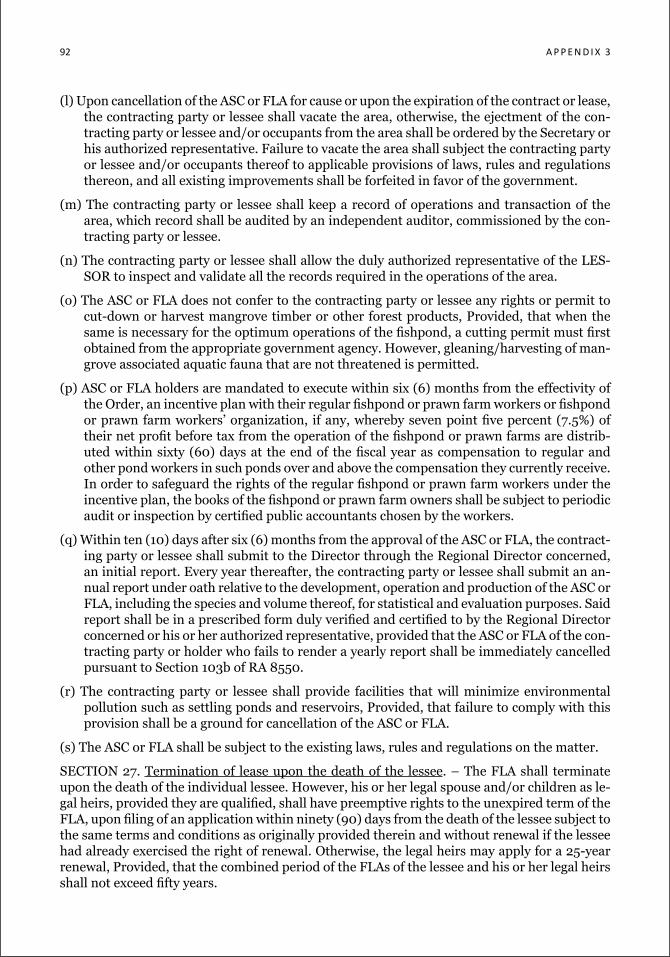
92 a P P e n d i x 3
(l) Upon cancellation of the ASC or FLA for cause or upon the expiration of the contract or lease, the contracting party or lessee shall vacate the area, otherwise, the ejectment of the con-tracting party or lessee and/or occupants from the area shall be ordered by the Secretary or his authorized representative. Failure to vacate the area shall subject the contracting party or lessee and/or occupants thereof to applicable provisions of laws, rules and regulations thereon, and all existing improvements shall be forfeited in favor of the government.
(m) The contracting party or lessee shall keep a record of operations and transaction of the area, which record shall be audited by an independent auditor, commissioned by the con-tracting party or lessee.
(n) The contracting party or lessee shall allow the duly authorized representative of the LES-SOR to inspect and validate all the records required in the operations of the area.
(o) The ASC or FLA does not confer to the contracting party or lessee any rights or permit to cut-down or harvest mangrove timber or other forest products, Provided, that when the same is necessary for the optimum operations of the fishpond, a cutting permit must first obtained from the appropriate government agency. However, gleaning/harvesting of man-grove associated aquatic fauna that are not threatened is permitted.
(p) ASC or FLA holders are mandated to execute within six (6) months from the effectivity of the Order, an incentive plan with their regular fishpond or prawn farm workers or fishpond or prawn farm workers’ organization, if any, whereby seven point five percent (7.5%) of their net profit before tax from the operation of the fishpond or prawn farms are distrib-uted within sixty (60) days at the end of the fiscal year as compensation to regular and other pond workers in such ponds over and above the compensation they currently receive. In order to safeguard the rights of the regular fishpond or prawn farm workers under the incentive plan, the books of the fishpond or prawn farm owners shall be subject to periodic audit or inspection by certified public accountants chosen by the workers.
(q) Within ten (10) days after six (6) months from the approval of the ASC or FLA, the contract-ing party or lessee shall submit to the Director through the Regional Director concerned, an initial report. Every year thereafter, the contracting party or lessee shall submit an an-nual report under oath relative to the development, operation and production of the ASC or FLA, including the species and volume thereof, for statistical and evaluation purposes. Said report shall be in a prescribed form duly verified and certified to by the Regional Director concerned or his or her authorized representative, provided that the ASC or FLA of the con-tracting party or holder who fails to render a yearly report shall be immediately cancelled pursuant to Section 103b of RA 8550.
(r) The contracting party or lessee shall provide facilities that will minimize environmental pollution such as settling ponds and reservoirs, Provided, that failure to comply with this provision shall be a ground for cancellation of the ASC or FLA.
(s) The ASC or FLA shall be subject to the existing laws, rules and regulations on the matter.
SECTION 27. Termination of lease upon the death of the lessee. – The FLA shall terminate upon the death of the individual lessee. However, his or her legal spouse and/or children as le-gal heirs, provided they are qualified, shall have preemptive rights to the unexpired term of the FLA, upon filing of an application within ninety (90) days from the death of the lessee subject to the same terms and conditions as originally provided therein and without renewal if the lessee had already exercised the right of renewal. Otherwise, the legal heirs may apply for a 25-year renewal, Provided, that the combined period of the FLAs of the lessee and his or her legal heirs shall not exceed fifty years.
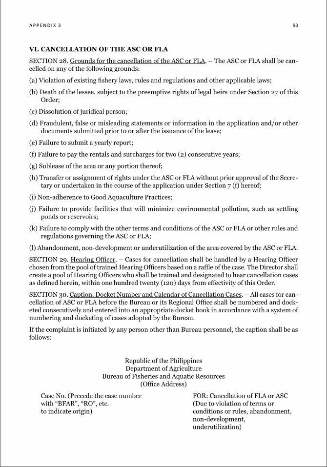
a P P e n d i x 3 93
VI. CANCELLATION OF THE ASC OR FLA
SECTION 28. Grounds for the cancellation of the ASC or FLA. – The ASC or FLA shall be can-celled on any of the following grounds:
(a) Violation of existing fishery laws, rules and regulations and other applicable laws;
(b) Death of the lessee, subject to the preemptive rights of legal heirs under Section 27 of this Order;
(c) Dissolution of juridical person;
(d) Fraudulent, false or misleading statements or information in the application and/or other documents submitted prior to or after the issuance of the lease;
(e) Failure to submit a yearly report;
(f) Failure to pay the rentals and surcharges for two (2) consecutive years;
(g) Sublease of the area or any portion thereof;
(h) Transfer or assignment of rights under the ASC or FLA without prior approval of the Secre-tary or undertaken in the course of the application under Section 7 (f) hereof;
(i) Non-adherence to Good Aquaculture Practices;
(j) Failure to provide facilities that will minimize environmental pollution, such as settling ponds or reservoirs;
(k) Failure to comply with the other terms and conditions of the ASC or FLA or other rules and regulations governing the ASC or FLA;
(l) Abandonment, non-development or underutilization of the area covered by the ASC or FLA.
SECTION 29. Hearing Officer. – Cases for cancellation shall be handled by a Hearing Officer chosen from the pool of trained Hearing Officers based on a raffle of the case. The Director shall create a pool of Hearing Officers who shall be trained and designated to hear cancellation cases as defined herein, within one hundred twenty (120) days from effectivity of this Order.
SECTION 30. Caption. Docket Number and Calendar of Cancellation Cases. – All cases for can-cellation of ASC or FLA before the Bureau or its Regional Office shall be numbered and dock-eted consecutively and entered into an appropriate docket book in accordance with a system of numbering and docketing of cases adopted by the Bureau.
If the complaint is initiated by any person other than Bureau personnel, the caption shall be as follows:
Republic of the Philippines Department of Agriculture
Bureau of Fisheries and Aquatic Resources (Office Address)
Case No. (Precede the case number FOR: Cancellation of FLA or ASC with “BFAR”, “RO”, etc. (Due to violation of terms or to indicate origin) conditions or rules, abandonment, non-development, underutilization)
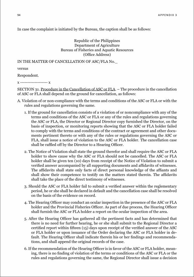
94 a P P e n d i x 3
In case the complaint is initiated by the Bureau, the caption shall be as follows:
Republic of the Philippines Department of Agriculture
Bureau of Fisheries and Aquatic Resources (Office Address)
IN THE MATTER OF CANCELLATION OF ASC/FLA No._
versus
Respondent.
x ------------------- x
SECTION 31. Procedure in the Cancellation of ASC or FLA. – The procedure in the cancellation of ASC or FLA shall depend on the ground for cancellation, as follows:
A. Violation of or non-compliance with the terms and conditions of the ASC or FLA or with the rules and regulations governing the same.
1. If the ground for cancellation consists of a violation of or noncompliance with any of the terms and conditions of the ASC or FLA or any of the rules and regulations governing the ASC or FLA, the Director or Regional Director copy furnished the Director, on the basis of inspection, or monitoring reports showing that the ASC or FLA holder failed to comply with the terms and conditions of the contract or agreement and other docu-ments pertinent thereto or with any of the rules or regulations governing the ASC or FLA, shall issue a notice of violation to the ASC or FLA holder. The cancellation case shall be raffled off by the Director to a Hearing Officer.
2. The Notice of Violation shall state the ground therefor and shall require the ASC or FLA holder to show cause why the ASC or FLA should not be cancelled. The ASC or FLA holder shall be given ten (10) days from receipt of the Notice of Violation to submit a verified answer accompanied by all supporting documents and affidavits of witnesses. The affidavits shall state only facts of direct personal knowledge of the affiants and shall show their competence to testify on the matters stated therein. The affidavits shall take the place of the direct testimony of witnesses.
3. Should the ASC or FLA holder fail to submit a verified answer within the reglementary period, he or she shall be declared in default and the cancellation case shall be resolved on the basis of the evidence on record.
4. The Hearing Officer may conduct an ocular inspection in the presence of the ASC or FLA holder and the Provincial Fisheries Officer. As part of due process, the Hearing Officer shall furnish the ASC or FLA holder a report on the ocular inspection of the area.
5. After the Hearing Officer has gathered all the pertinent facts and has determined that there is no need for further hearing, he or she shall submit to the Regional Director a certified report within fifteen (15) days upon receipt of the verified answer of the ASC or FLA holder or upon issuance of the Order declaring the ASC or FLA holder in de-fault. The Hearing Officer shall indicate therein his or her findings and recommenda-tions, and shall append the original records of the case.
6. If the recommendation of the Hearing Officer is in favor of the ASC or FLA holder, mean-ing, there is no finding of violation of the terms or conditions of the ASC or FLA or the rules and regulations governing the same, the Regional Director shall issue a decision
a P P e n d i x 3 95
dismissing the cancellation case within fifteen (15) days from receipt of the report of the Hearing Officer.
7. The complainant may move for the reconsideration of the Decision of the Regional Di-rector dismissing the Complaint for Cancellation by filing an appropriate motion spe-cifically indicating the grounds therefor, with proof of service of copies thereof to the respondent and the Director within fifteen (15) days from the receipt of the Decision dismissing the complaint. The respondent and the other parties shall file with the Re-gional Director their comments within ten (10) days from receipt of the said motion. Thereafter, the motion shall be considered submitted for resolution, whether or not such comments are filed.
8. Only one motion for reconsideration of the decision of the Regional Director shall be allowed. All papers and other documents subsequently filed shall be considered sup-plements. The Regional Director shall decide the motion for reconsideration within fifteen (15) days from its submission. The filing of a motion for reconsideration shall suspend the running of the period to appeal.
9. Any decision or resolution of the Regional Director dismissing the Complaint for Can-cellation shall become final and executory after fifteen (15) days from the date of re-ceipt thereof, unless a motion for reconsideration is filed or an appeal to the Secretary through the Director is perfected within said period.
10. If the recommendation is for the cancellation of the ASC or FLA, the Regional Director shall endorse the findings of the Hearing Officer to the Director, within ten (10) days from receipt of the report of the Hearing Officer.
11. Upon receipt of the endorsement from the Regional Director recommending the can-cellation of the ASC or FLA, the Director shall study the case. Whenever the Director agrees that there is prima facie evidence that the ASC or FLA holder violated the terms and conditions of the ASC or FLA or the rules or regulations governing the same, he or she shall recommend to the Secretary the cancellation of the FLA, within thirty (30) days from receipt of the endorsement.
12. If the Secretary agrees with the findings of the Director, he or she shall issue the Order of Cancellation of the ASC or FLA and shall declare the area available to any qualified applicant. The Order shall clearly and distinctly state the facts and the law on which it is based. The Order shall also indicate the forfeiture of the cash bond posted by the ASC or FLA holder and the improvements in favor of the government. Copy of the Order of Cancellation shall be sent to the ASC or FLA holder ten (10) days from issuance of the signed Order.
B. Abandoned or Undeveloped Areas
1. The Director or the Regional Director copy furnished the Director, either acting on the inspection report of its regional personnel, or upon written petition of the DENR, the Local Government Unit, MFARMC or resident of the area representing his or her com-munity or any people’s organization or non-government organization, shall issue a No-tice of Violation to the ASC or FLA holder on the ground that the area is abandoned or undeveloped. The cancellation case shall be raffled off by the Director to a Hearing Officer.
2. The Notice of Violation shall state the ground therefor and shall require the ASC or FLA holder to show cause why the ASC or FLA should not be cancelled. The ASC or FLA
96 a P P e n d i x 3
holder shall be given ten (10) days from receipt of the Notice of Violation to submit a verified answer accompanied by all supporting documents and affidavits of witnesses. The affidavits shall state only facts of direct personal knowledge of the affiants and shall show their competence to testify on the matters stated therein. The affidavits shall take the place of the direct testimony of witnesses. Should the ASC or FLA holder fail to submit his or her answer within the reglementary period, he or she shall be de-clared in default by the Hearing Officer and the cancellation case shall be resolved on the basis of the evidence on record.
3. The Hearing Officer shall, within ten (10) days from receipt of the verified answer or is-suance of the Order declaring the ASC or FLA holder in default, convene a composite team to be comprised of the Provincial Fisheries Officer, the Community Environment and Natural Resources Officer, the Municipal/City Environment and Natural Resour-ces Officer and the MFARMC Chairman for the conduct of the joint ocular inspection. Notice of the joint ocular inspection shall be given to the ASC or FLA holder at least ten (10) days prior to the scheduled date of inspection. The inspection team shall de-termine whether the area is abandoned or undeveloped and whether the area, either in whole or in part, can be reverted to its original mangrove state.
4. If the composite team finds the area not to be abandoned or undeveloped, the Hearing Officer shall prepare a report to be signed by all the members of the composite team. The Hearing Officer shall furnish the ASC or FLA holder copy of the report and submit the same to the Regional Director within fifteen (15) days from the conduct of the in-spection. The Regional Director shall issue an order dismissing the case within ten (10) days from receipt of the report, copy furnished the Director and the ASC or FLA holder.
5. Upon a determination that the area is abandoned or undeveloped and that it can, either in whole or in part, be reverted to its original mangrove state, the Hearing Officer shall submit a report to the Regional Director, recommending the cancellation of the ASC or FLA and the reversion of either the whole area or portions thereof.
6. The Regional Director shall endorse the findings of the Hearing Officer to the Director within fifteen (10) days from receipt of the report of the Hearing Officer. Upon receipt of the endorsement from the Regional Director recommending the cancellation of the ASC or FLA, the Director shall study the case. Whenever the Director agrees that there is prima facie evidence that the area is abandoned or undeveloped, he or she shall recommend to the Secretary the cancellation of the ASC or FLA and the reversion of either the whole area or portions thereof within thirty (30) days from receipt of the endorsement.
7. If the Secretary agrees with the findings of the Director, he or she shall issue the Order of Cancellation of the ASC or FLA and shall declare the reversion of the area or por-tions thereof to the DENR. Portions of the abandoned or undeveloped area that cannot be restored to its original mangrove state shall remain under the jurisdiction of the Bureau to be either declared as reserved areas for fish sanctuary, or reserved areas for conservation and ecological purposes pursuant to Section 45 of RA 8550 or be made available for ASC. The Order shall clearly and distinctly state the facts and the law on which it is based. The Order shall also indicate the forfeiture of the cash bond posted by the ASC or FLA holder and the improvements in favor of the government. Copy of the Order of Cancellation and Reversion shall be sent to the ASC or FLA holder and the DENR within ten (10) days from issuance of the signed Order.
a P P e n d i x 3 97
C. Underutilized Areas
1. The Director or the Regional Director copy furnished the Director, either acting on the inspection reports of its regional personnel, or upon written petition of the DENR, the Local Government Unit or a resident of the area representing his or her community or any people’s organization or non-government organization, shall issue a Notice of Violation to the ASC or FLA holder on the ground that the area is underutilized. The cancellation case shall be raffled off by the Director to a Hearing Officer.
2. The Notice of Violation shall state the ground therefor and shall require the ASC or FLA holder to show cause why his or her ASC or FLA should not be cancelled. The ASC or FLA holder shall be given ten (10) days from receipt of the Notice of Violation to sub-mit his or her verified answer accompanied by all supporting documents and affidavits of its witnesses. The affidavits shall state only facts of direct personal knowledge of the affiants and shall show their competence to testify on the matters stated therein. The affidavits shall take the place of the direct testimony of witnesses. Should the ASC or FLA holder fail to submit his or her answer within the reglementary period, he or she shall be declared in default by the Hearing Officer and the cancellation case shall be resolved on the basis of the evidence on record.
3. The Hearing Officer shall, within ten (10) days from receipt of the verified answer or is-suance of the Order declaring the ASC or FLA holder in default, convene a composite team to be comprised of the Provincial Fisheries Officer, the DENR CENRO, the LGU Menro and the MFARMC Chairman for the conduct of the joint ocular inspection. No-tice of the joint ocular inspection shall be given to the ASC or FLA holder at least ten (10) days from the scheduled date of inspection. The inspection team shall determine whether the area is underutilized.
4. If the composite team finds the area not to be underutilized, the Hearing Officer shall prepare a report to be signed by all the members of the composite team. The Hearing Officer shall furnish the ASC or FLA holder a copy of the report and submit the same to the Regional Director within fifteen (15) days from the conduct of the inspection. The Regional Director shall issue an order dismissing the case within ten (10) days from receipt of the report, copy furnished the Director and the ASC or FLA holder.
5. Upon a determination that the area is underutilized, the composite team shall determine the reasons therefor. If there are valid reasons for the underutilization of the area, such as but not limited to the following: unstable peace and order, protest against the ASC or FLA or adverse claims, the Regional Director shall direct the ASC or FLA holder to fully develop the area within a period of two (2) years from receipt of a written order, copy furnished the Director.
6. If the ASC or FLA holder fails to show cause for the underutilization or fails to fully develop the area within two (2) years, the Regional Director shall recommend to the Director the cancellation of the ASC or FLA. Upon receipt of the endorsement from the Regional Director recommending the cancellation of the ASC or FLA, the BFAR Direc-tor shall study the case. Whenever the BFAR Director agrees that there is prima facie evidence that the area is underutilized, he or she shall recommend to the Secretary of the DA the cancellation of the ASC or FLA within thirty (30) days from receipt of the endorsement.
7. If the Secretary of Agriculture agrees with the findings of the Director, he or she shall issue the Order of Cancellation of the ASC or FLA and shall declare the area avail-able and open to any qualified applicant for ASC or FLA. The Order shall clearly and
98 a P P e n d i x 3
distinctly state the facts and the law on which it is based. The Order shall also indicate the forfeiture of the cash bond posted by the ASC or FLA holder and the improvements in favor of the government. Copy of the Order of Cancellation shall be sent to the ASC or FLA holder ten (10) days from issuance of the signed Order.
SECTION 32. Motion for Reconsideration. – The ASC or FLA holder may move for the re-consideration of an Order of Cancellation and/or Reversion by filing an appropriate motion specifically indicating the grounds therefor, with proof of service of copies thereof to the Direc-tor. The Director shall file with the Secretary his or her comments within ten (10) days from receipt of the said motion. Thereafter, the motion shall be considered submitted for resolution, whether or not such comment is filed. Only one motion for reconsideration of an order of the Secretary shall be allowed. All papers and other documents subsequently filed shall be consid-ered supplements. The Secretary shall decide the motion for reconsideration within fifteen (15) days from its submission. The filing of a motion for reconsideration shall suspend the running of the period to appeal.
SECTION 33. Finality of Order and Period to Appeal. – Subject to the provisions of the preced-ing rule, any order, resolution or decision of the Secretary shall become final and executory after fifteen (15) days from the date of receipt thereof, unless a motion for reconsideration is filed or an appeal is perfected within said period. The mere filing of an appeal shall not stay the decision of the Secretary.
SECTION 34. Execution of Order or Resolution. – The orders and resolutions of the Secretary, after they have become final and executory, shall be enforced and executed through the issu-ance of the Writ of Execution to the Director. The latter in turn shall direct the Regional Direc-tor to enforce the writ. The Regional Director shall ensure that the structures in the area, if there be any are appropriately dismantled and the illegal occupants be evicted, if there be any. The Regional Director may seek the assistance of Local Government Unit concerned and other law enforcement institutions, such as the Philippine National Police, for carrying out the Writ of Execution.
SECTION 35. Return of the Writ of Execution. – The Director shall make a return of the Writ to the Secretary at any time not less than ten (10) days or more than sixty (60) days after its receipt. The Director shall submit to the Secretary a report on the whole proceedings taken to enforce and execute the order, resolution or decision, together with the corresponding proof of service, within forty-eight (48) hours after the completion of the enforcement and execution.
VII. FINAL PROVISIONS
SECTION 36. Disposition of improvements. – Upon the cancellation or termination of the ASC or FLA, the existing improvements on the area subject of the contract or lease shall become property of the government. The improvements shall be assessed and sold at current market value to the qualified ASC or FLA applicant to answer for any unpaid rentals and surcharges incurred by the previous ASC or FLA holder.
SECTION 37. Unlawful use or occupation of public lands released for fishpond purposes. – Any person illegally occupying or introducing improvements in areas released for fishpond development without a permit, contract or lease, shall be liable for prosecution for the offense of mangrove conversion, without prejudice to the filing of other administrative or criminal charges.
SECTION 38. FLAs foreclosed by assignee-banks. – For FLAs mortgaged to banks or financial institutions prior to the effectivity of this Order, in the event of default in the payment of the
a P P e n d i x 3 99
loan by the lessee and the assignee-bank enforces the terms and conditions of the assignment of rights, the said assignee-bank shall have a period of five (5) years thereafter to hold the area covered by the lease for the purpose of liquidating the debt, disposing of the improvements therein, and negotiating for the transfer or assignment of the rights therein to other qualified transferees who shall comply with the requirements of the Secretary. For this purpose, the assignee-bank shall notify the Secretary when such enforcement will commence. However, if after the period of five (5) years has lapsed and no transfer has been effected, then the area shall be automatically reverted to the Secretary for proper disposition, subject to the rights of the assignee bank. Released areas that have been foreclosed by the Development Bank of the Philippines or any financial institution pursuant to a loan agreement approved by the Secretary shall not be considered as abandoned or undeveloped fishponds although the same may not be operational or commercially producing. After the effectivity of this Order, the rights over an ASC or FLA can no longer be assigned or used as collateral for loans from banks and other financial institutions.
SECTION 39. Administrative and Court Action. – The Secretary, the Director or their duly au-thorized representative may take action either administrative or judicial, as may be necessary and proper to carry into effect the provisions of this Order.
SECTION 40. Adverse Claim or Protest. – Any person who has an adverse claim or protest over the area which is the subject of application for an ASC or FLA shall file his claim or protest with the Bureau within thirty (30) days from knowledge thereof, otherwise such claim or protest shall not be entertained.
SECTION 41. Separability Clause. – If any section or provision of this Order, or part thereof, is declared unconstitutional or invalid, the other sections or provisions thereof which are not affected thereby shall continue in full force and effect.
SECTION 42. Repealing clause. – Revised Fisheries Administrative Order No. 60 series of 1960, Fisheries Administrative Order No. 125 series of 1979 and Fisheries Administrative Or-der No. 197 series of 2000 are hereby repealed. Other fishery rules and regulations which are inconsistent with the provisions of this Order are hereby repealed or modified accordingly.
SECTION 43. Effectivity. – This Administrative Order shall take effect after fifteen (15) days following the completion of Its publication in a newspaper of genera) circulation and its filing with the Office of the National Administrative Register (ONAR).
Issued this 17th day of Dec. , 2012, in Quezon City, Metro Manila, Philippines.
SIGNED PROCESO J. ALCALA Secretary
RECOMMENDED BY:
SIGNED SIGNED SALVADOR S. SALACUP ATTY. ASIS G. PEREZ Assistant Secretary for Fisheries and Director, BFAR NFARMC Chairman
Published in the Philippine Star Classifinder Sec. B-16 to 17 December 21, 2012 Filed with the ONAR, January 03, 2013
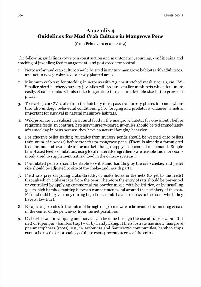
100 a P P e n d i x 4
Appendix 4 Guidelines for Mud Crab Culture in Mangrove Pens
(from Primavera et al., 2009)
The following guidelines cover pen construction and maintenance; sourcing, conditioning and stocking of juveniles; feed management; and pest/predator control:
1. Netpens for mud crab culture should be sited in mature mangrove habitats with adult trees, and not in newly-colonized or newly planted areas.
2. Minimum crab size for stocking in netpens with 2.3 cm stretched mesh size is 3 cm CW. Smaller-sized hatchery/nursery juveniles will require smaller mesh nets which foul more easily. Smaller crabs will also take longer time to reach marketable size in the grow-out phase.
3. To reach 3 cm CW, crabs from the hatchery must pass 1-2 nursery phases in ponds where they also undergo behavioral conditioning (for foraging and predator avoidance) which is important for survival in natural mangrove habitats.
4. Wild juveniles can subsist on natural food in the mangrove habitat for one month before requiring feeds. In contrast, hatchery/nursery-reared juveniles should be fed immediately after stocking in pens because they have no natural foraging behavior.
5. For effective pellet feeding, juveniles from nursery ponds should be weaned onto pellets (minimum of 2 weeks) before transfer to mangrove pens. (There is already a formulated feed for mudcrab available in the market, though supply is dependent on demand. Simple farm-based feed formulations using local materials/ingredients are feasible and more com-monly used to supplement natural food in the culture systems.)
6. Formulated pellets should be stable to withstand handling by the crab chelae, and pellet size should be adjusted to size of the chelae and mouth parts.
7. Field rats prey on young crabs directly, or make holes in the nets (to get to the feeds) through which crabs escape from the pens. Therefore the entry of rats should be prevented or controlled by applying commercial rat powder mixed with boiled rice, or by installing 50 cm-high bamboo matting between compartments and around the periphery of the pen. Feeds should be given only during high tide, so rats have no access to the food (which they have at low tide).
8. Escapes of juveniles to the outside through deep burrows can be avoided by building canals in the center of the pen, away from the net partitions.
9. Crab retrieval for sampling and harvest can be done through the use of traps – bintol (lift net) or tapangan (bamboo trap) – or by handpicking. If the substrate has many mangrove pneumatophores (roots), e.g., in Avicennia and Sonneratia communities, bamboo traps cannot be used as morphology of these roots prevents access of the crabs.
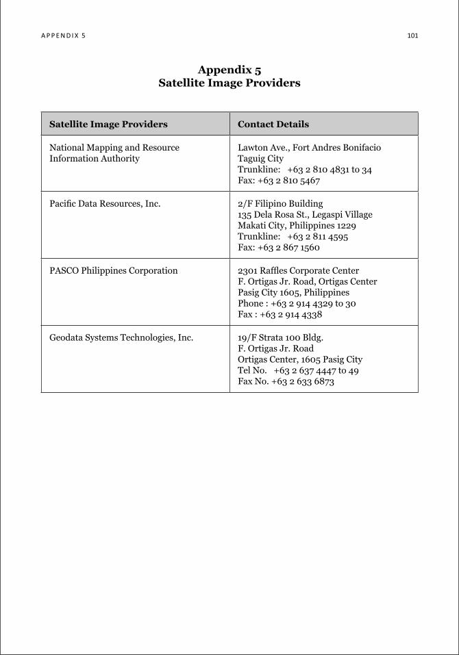
a P P e n d i x 5 101
Appendix 5 satellite Image providers
satellite Image providers Contact details
National Mapping and Resource Information Authority
Lawton Ave., Fort Andres BonifacioTaguig CityTrunkline: +63 2 810 4831 to 34Fax: +63 2 810 5467
Pacific Data Resources, Inc. 2/F Filipino Building135 Dela Rosa St., Legaspi VillageMakati City, Philippines 1229Trunkline: +63 2 811 4595Fax: +63 2 867 1560
PASCO Philippines Corporation 2301 Raffles Corporate CenterF. Ortigas Jr. Road, Ortigas CenterPasig City 1605, PhilippinesPhone : +63 2 914 4329 to 30 Fax : +63 2 914 4338
Geodata Systems Technologies, Inc. 19/F Strata 100 Bldg.F. Ortigas Jr. Road Ortigas Center, 1605 Pasig City Tel No. +63 2 637 4447 to 49Fax No. +63 2 633 6873

102 a P P e n d i x 6
Appendix 6 Data sheet for recording information on fishpond lots found in tax
declaration certificates, Municipal Assessor’s Office
Municipality: _________________ Province: _________________
Tax Dec No.
Name of Tax DeclarantTCT/
OCT No.FLA No.
Location (Sitio and Barangay)
Area (ha)
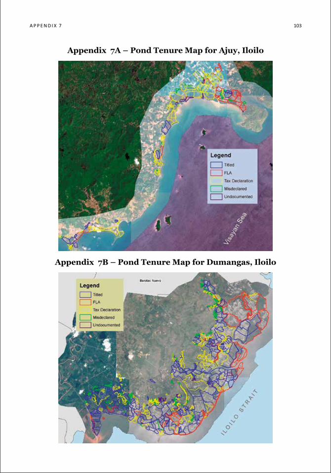
a P P e n d i x 7 103
Appendix 7A – Pond Tenure Map for Ajuy, Iloilo
Appendix 7B – Pond Tenure Map for Dumangas, Iloilo
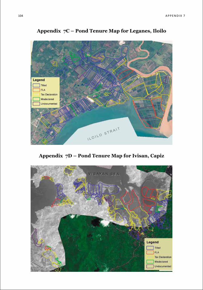
104 a p p e n d i x 7
Appendix 7C – Pond Tenure Map for Leganes, Iloilo
Appendix 7D – Pond Tenure Map for Ivisan, Capiz
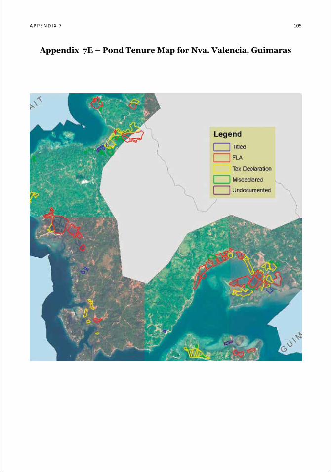
a P P e n d i x 7 105
Appendix 7E – Pond Tenure Map for Nva. Valencia, Guimaras
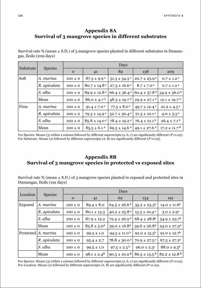
106 a P P e n d i x 8
Appendix 8A Survival of 3 mangrove species in different substrates
Survival rate % (mean ± S.D.) of 3 mangrove species planted in different substrates in Duman-gas, Iloilo (209 days)
Substrate SpeciesDays
0 41 82 138 209
Soft A. marina 100 ± 0 87.3 ± 9.9 a 51.3 ± 34.5 a 20.7 ± 23.9 a 0.7 ± 1.2 a
R. apiculata 100 ± 0 80.7 ± 14.8 a 27.3 ± 16.6 a 8.7 ± 7.0 a 0.7 ± 1.2 a
S. alba 100 ± 0 89.9 ± 12.8 a 66.4 ± 36.4 a 60.4 ± 37.8 b 34.9 ± 36.0 b
Mean 100 ± 0 86.0 ± 4.7 A 48.3 ± 19.7 A 29.9 ± 27.1 A 12.1 ± 19.7 A
Firm A. marina 100 ± 0 91.4 ± 7.0 a 77.5 ± 8.0 a 49.7 ± 12.4 a 21.2 ± 4.5 a
R. apiculata 100 ± 0 79.3 ± 14.9 a 52.7 ± 30.4 a 21.3 ± 10.1 a 4.0 ± 3.5 a
S. alba 100 ± 0 85.8 ± 14.0 a 78.4 ± 19.2 a 76.4 ± 21.1 b 26.4 ± 7.1 b
Mean 100 ± 0 85.5 ± 6.1 A 69.5 ± 14.6 A 49.1 ± 27.6 A 17.2 ± 11.7 B
For Species: Means (3) within a column followed by different superscripts (a, b, c) are significantly different (P<0.05).For Substrate: Means (2) followed by different superscripts (A, B) are significantly different (P<0.05).
Appendix 8B Survival of 3 mangrove species in protected vs exposed sites
Survival rate % (mean ± S.D.) of 3 mangrove species planted in exposed and protected sites in Dumangas, Iloilo (191 days)
Location SpeciesDays
0 41 62 134 191
Exposed A. marina 100 ± 0 89.4 ± 8.0 64.5 ± 26.6 b 35.2 ± 23.3b 14.0 ± 11.6b
R. apiculata 100 ± 0 80.1 ± 13.3 40.2 ± 25.8 a 15.3 ± 10.4 a 3.0 ± 2.9a
S. alba 100 ± 0 87.9 ± 12.2 72.4 ± 26.9 b 68.4 ± 28.8c 54.9 ± 23.7b
Mean 100 ± 0 85.8 ± 5.0A 59.0 ± 16.8A 39.6 ± 26.8A 24.0 ± 27.3A
Protected A. marina 100 ± 0 99.5 ± 1.0 94.5 ± 11.0 b 92.0 ± 13.5b 91.0 ± 12.7b
R. apiculata 100 ± 0 95.4 ± 2.7 78.8 ± 30.0 a 70.9 ± 27.5 a 67.5 ± 27.2a
S. alba 100 ± 0 99.5 ± 1.0 97.5 ± 2.5 b 96.0 ± 2.3c 88.0 ± 9.5b
Mean 100 ± 0 98.1 ± 2.4B 90.3 ± 10.0 B 86.3 ± 13.5 B 82.2 ± 12.8 B
For Species: Means (3) within a column followed by different superscripts (a, b, c) are significantly different (P<0.05).For Location: Means (2) followed by different superscripts (A, B) are significantly different (P<0.05).
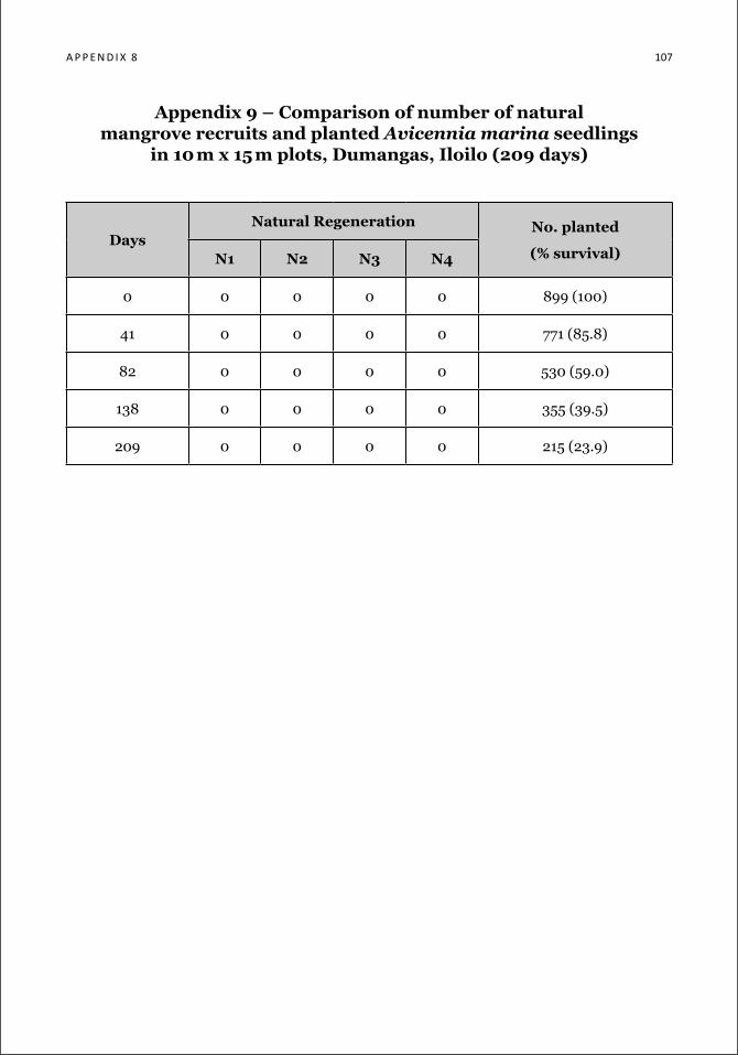
a P P e n d i x 8 107
Appendix 9 – Comparison of number of natural mangrove recruits and planted Avicennia marina seedlings
in 10 m x 15 m plots, Dumangas, Iloilo (209 days)
daysNatural regeneration No. planted
(% survival)N1 N2 N3 N4
0 0 0 0 0 899 (100)
41 0 0 0 0 771 (85.8)
82 0 0 0 0 530 (59.0)
138 0 0 0 0 355 (39.5)
209 0 0 0 0 215 (23.9)
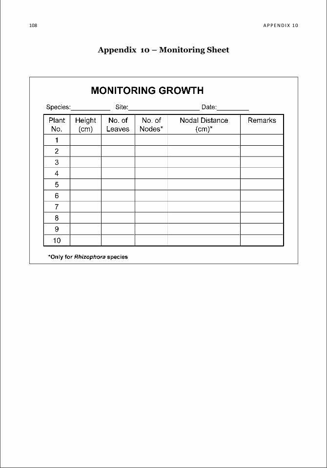
108 a P P e n d i x 10
Appendix 10 – Monitoring Sheet


the Zoological society of london
Founded in 1826, ZSL is an international science, conservation and education charity (no. 208728), whose mission is to promote and achieve the worldwide conservation of animals and their habitats. ZSL pursues this mission through three main fields of activity:
• Conservation – ZSL’s Conservation Programmes department is actively involved in field conservation in over 50 countries worldwide. ZSL’s wide-ranging conserva-tion work aims to build capacity and influence policy, to bring direct and sustainable conservation benefits to wild animals and their habitats, with activities typically un-dertaken by forming partnerships with local organisations and government depart-ments;
• Science – the Institute of Zoology identifies, undertakes and communicates high quality biological research relevant to the conservation of animals and their habitats;
• Education and inspiration – ZSL presents and interprets outstanding living col-lections of animals at ZSL London Zoo and ZSL Whipsnade Zoo. The zoos receive around 1.5 million visitors a year and are supported by some 250 volunteers.
ZSL’s strategic aims are to: undertake and promote relevant high quality zoological and conservation research to help achieve our conservation objectives and to inform and influence conservation policy; encourage and motivate all our stakeholders to support and engage in conservation; and to implement and achieve effective and appropriate in-situ and ex-situ conservation programmes for priority species and habitats.
The big lottery Fund
The Big Lottery Fund is the largest distributor of UK Lottery money to good causes. The Big Lottery Fund (BIG) is responsible for delivering 40 per cent of all funds raised for good causes (about 13 pence of every pound spent on a Lottery Ticket) by The National Lottery.
Since June 2004, BIG has awarded over £4.4bn to projects supporting health, educa-tion, environment and charitable purposes. Most of our funding is awarded to volun-tary and community sector organisations.
BIG is a non-departmental public body sponsored by the Cabinet Office.
acccoast project
This edition is supported by the German Ministry for the Environment, Nature Con-servation and Nuclear Safety (BMU) through the Adaptation to Climate Change in Coastal Areas (ACCCoast) project of the Deutsche Gesellschaft für Internationale Zusammenarbeit (GIZ) GmbH, in collaboration with the Department of Environment and Natural Resources – Protected Areas and Wildlife Bureau (DENR-PAWB).