Embed Size (px)
Citation preview
Nachrichten für SeefahrerNotices to Mariners
Amtliche Veröffentlichung für die SeeschifffahrtOfficial Maritime Publication
3. Januar 2014 · 145. Jahrgang · Heft 13 January 2014 · Volume 145 · Issue 1
Karten, Leuchtfeuerverzeichnisse, Seehandbücher usw.
bitte sofort berichtigen
Charts, List of Lights, Sailing Directions etc. to be corrected immediately
Geographische Länge bezogen auf den Nullmeridian.Geographic longitude referred to Greenwich meridian.Kurse und Peilungen rechtweisend in Graden von 000° bis 360°.True courses and bearings in degrees from 000° to 360°.Sektorengrenzen der Feuer von See aus.Sector limits of lights from seaward.Tragweiten für 10 sm meteorologische Sichtweite; Sichtweiten für 5 m Augeshöhe.Luminous ranges at 10 nautical miles meteorological visibility, at 5 m height of eye.Tiefenangaben und trockenfallende Höhen bezogen auf das Kartennull.Depths and drying heights referred to Chart Datum.Andere Höhen bezogen auf kartenspezifische Höhenbezugsflächen.Other heights referred to chart specific height datum.Entfernungsangaben in metrischen Maßen sowie in Seemeilen (sm) und Kabellängen (kbl).Distances in metric units, nautical miles, and cable lenghts.Zeichen und Abkürzungen in den deutschen Seekarten siehe Karte 1/INT 1.For symbols and abbreviations used in the German nautical charts, please refer to Karte 1/INT 1.Weitere Abkürzungen und Erklärungen im jährlichen Vorwort in Heft 1 der NfS sowie im Handbuch für Brücke und Kartenhaus.Additional abbreviations and explanations are provided in the preface to the annual NfS issue 1 and “Handbuch für Brücke und Kartenhaus”.
Freiwillige Mitarbeit/Voluntary cooperation
Jeder Hinweis zur Vervollständigung oder Berichtigung der nautischen Veröffentlichungen dient der Sicherheit aller Seefahrer. Beiträge erbitten wir an das:Any information provided to supplement or correct nautical publications will help to improve the safety of all mari-ners. Such information should be sent to:
Bundesamt für Seeschifffahrt und HydrographieNeptunallee 518057 Rostock
Telefon/Telephone +49 (0) 3 81 45 63-5 (Vermittlung/operator)Telefax +49 (0) 3 81 45 63-7 69 E-Mail [email protected] www.bsh.de
Die Inhalte dieses Werkes sind rechtlich geschützt. Die dadurch begründeten Rechte, insbesondere die der Über-setzung, des Nachdrucks, des Vortrags, der Entnahme von Abbildungen und Tabellen, der Verbreitung, der Mikro-verfilmung oder der Vervielfältigung auf anderen Wegen und der Speicherung bleiben, auch bei nur auszugsweiser Verwertung, vorbehalten. Eine Vervielfältigung dieses Werkes oder von Teilen dieses Werkes ist auch im Einzelfall nur in den Grenzen der gesetzlichen Bestimmungen der Bundesrepublik Deutschland zulässig.The contents of this publication are protected by copyright. All rights are reserved, specifically the rights of trans-lation, reprinting, recitation, reuse of illustrations and tables, promulgation, reproduction on microfilm or in any other way, as well as the right of storage, either in whole or in part. Reproduction of this publication or parts of this publi cation is permitted only under the provisions of German law, also in individual cases.
© Bundesamt für Seeschifffahrt und Hydrographie (BSH)Hamburg und Rostock 2014
ISSN-Nr. 1437-4048BSH-Nr. 2119
Verbindlicher Endpreis monatlich j 10,00 inkl. MwSt., Einzelheft j 3,00 inkl. MwSt. (zzgl. Postzustellgebühr)(für den Europäischen Wirtschaftsraum gelten die Preise als „Unverbindliche Preisempfehlung“)Fixed price per month k 10.00 incl. VAT, single issue k 3.00 incl. VAT (plus postage)(In the European Economic Area, the above prices are recommended prices)
III
V o r w o r t / P r e f a c e 1/14
Inhalt/Contents
Vorwort/Preface
1 Nautischer Warn- und Nachrichtendienst der Bundesrepublik Deutschland Navigational Warning and Information Service of the Federal Republic of Germany . . . . . . . . . . . . . . . . . IV
2 Nautische Veröffentlichungen nach der Schiffssicherheitsverordnung Nautical publications according to the Ship Safety Ordinance . . . . . . . . . . . . . . . . . . . . . . . . . . . . . . . . . . XIII
3 Amtliche Seekarten und Seebücher/Official nautical charts and books . . . . . . . . . . . . . . . . . . . . . . . . . . . XVI
4 Dienststellen, bei denen die Nachrichten für Seefahrer ausliegen Agencies where German Notices to Mariners are available for consultation . . . . . . . . . . . . . . . . . . . . . . . XVII
5 Stellen, bei denen Nachrichten für Seefahrer anderer hydrographischer Dienste ausliegen Agencies where Notices to Mariners of other Hydrographic Offices are available for consultation . . . . . . XVIII
6 Abkürzungen/Abbreviations . . . . . . . . . . . . . . . . . . . . . . . . . . . . . . . . . . . . . . . . . . . . . . . . . . . . . . . . . . . . XIX
Kartenberichtigungen/Corrections to Charts
Teil 1 – Deutsche Karten/Part 1 – German Charts . . . . . . . . . . . . . . . . . . . . . . . . . . . . . . . . . . . . . . . . . . . . . 1.1Teil 1 A – Britische Karten/Part 1 A – British Charts . . . . . . . . . . . . . . . . . . . . . . . . . . . . . . . . . . . . . . . . . . . . . 1.7
Handbuchberichtigungen/Corrections to Sailing Directions
Teil 2 – Deutsche Seehandbücher/Part 2 – German Sailing Directions . . . . . . . . . . . . . . . . . . . . . . . . . . . . . . . . . . . . . . . . . . . . . . . . . . . . . . . . 2.1
Katalogberichtigungen/Corrections to Catalogue
Teil 3 – Deutscher Katalog/Part 3 – German Catalogue . . . . . . . . . . . . . . . . . . . . . . . . . . . . . . . . . . . . . . . . 3.1Teil 3 A – Britische Veröffentlichungen/Part 3 A – New Editions of Admiralty Charts and Publications . . . . . . . 3.2
Mitteilungen/Notifications
Teil 4 – Mitteilungen, normale/Part 4 – Notifications, general . . . . . . . . . . . . . . . . . . . . . . . . . . . . . . . . . . . . 4.1Teil 4 A – Abdrucke besonderer Mitteilungen/Part 4 A – Reprints of special Notifications . . . . . . . . . . . . keine/nil
Beilagen/Enclosures
• Deckblätter zu den Krt./Blocks (Chartlets) for Charts: (11) GB 2278
• Liste der noch gültigen P- und T-Berichtigungen/List of P and T corrections in Force
• Liste der Seegebiete und der ihnen zugeordneten Seekarten/List of sea areas and charts relating to them
• Anlaufbedingungsverordnung – AnlBV/Internal Waters (Entering Requirements) Ordinance
Neuerscheinungen des BSH/New BSH publications
Bücher/Books: –
Krt./Charts: (11) 151, (16) 32/INT 1359, (16) 33/INT 1364, (17) 25/INT 1301, (21) 44/INT 1452
1/14 V o r w o r t / P r e f a c e
IV
1 Navigational Warning and
Information Service of the
Federal Republic of Germany
1.1 NACHRICHTEN FÜR SEEFAHRER (NfS, Notices to Mariners) The NfS are issued weekly by the Bundesamt
für Seeschifffahrt und Hydrographie (BSH, Federal Maritime and Hydrographic Agency) in Hamburg and Rostock. Hydrographic notes should be sent to
Bundesamt für Seeschifffahrt und Hydrographie Neptunallee 5 18057 Rostock
Phone: +49 (0) 3 81 45 63-5 (operator) Fax: +49 (0) 3 81 45 63-9 48, or 7 69 (Navigational Information Service) e-mail: [email protected] Web: www.bsh.de
The NfS provide information on important navigational measures, incidents, and changes concerning the German navigable waterways, the high seas, and the territorial waters of other European states (the greater part in German/English). The notices enable the mari-ner to keep his nautical publications up-to-date. Especially changes in lighting and buoying in the coastal waters, obstructions and dangers in the coast-al area and on the high seas as well as official an-nouncements and ordinances which are relevant to the mariner are published in the NfS.
Navigational information that is of particular to ship-ping or affects marine environmental protection is published in advance in NfS, part 4, Notifications.
Where areas within the BSH’s responsibility are not, or not adequately, covered by the official German nautical charts and books, information from the offi-cial UK nautical charts and books will be taken into account, and the UK Notices to Mariners (NtM) cor-rection system will be re-printed in the NfS. Such UK charts are shown in the List of Sea Areas and Charts Relating to them (enclosure to NfS issue 1 respec-tively 27).
The decision whether, apart from these publications, additional charts and books of foreign Hydrographic Offices are necessary for the intended voyage has to be taken by the vessel’s Master.
However, navigational charts and books which are not included in the national German list of nautical charts and books can be corrected only inadequately by the NfS, or not at all, especially if the Master is not aware of possible lattice differences between positions given in the NfS and such other charts.
1 Nautischer Warn- und
Nachrichtendienst der
Bundesrepublik Deutschland
1.1 NACHRICHTEN FÜR SEEFAHRER (NfS)
Die NfS werden vom Bundesamt für Seeschiff-fahrt und Hydrographie (BSH) in Hamburg und Rostock wöchentlich herausgegeben. Die An-schrift für Einsender lautet:
Bundesamt für Seeschifffahrt und Hydrographie Neptunallee 5 18057 Rostock
Telefon: +49 (0) 3 81 45 63-5 (Vermittlung) Fax: +49 (0) 3 81 45 63-9 48 oder 7 69 (Nautischer Informationsdienst) E-Mail: [email protected] Internet: www.bsh.de
In den NfS werden für die Schifffahrt wichtige Maß-nahmen, Ereignisse und Veränderungen auf den Seeschifffahrtsstraßen Deutschlands, auf der Hohen See oder in den Hoheitsgewässern anderer Staaten im europäischen Bereich (überwiegend in Deutsch/Englisch) bekanntgegeben. Die Meldungen ermög-lichen eine Berichtigung der nauti schen Veröffent-lichungen. Insbesondere werden Veränderungen in der Befeuerung und Betonnung der Küstengewässer, Schifffahrtshindernisse und Gefahren im Küstenge-biet und auf See sowie Bekanntmachungen und Ver-ordnungen von Behörden, soweit sie für die Schiffs-führung von Bedeutung sind, ver öffentlicht.
Besondere nautische Informationen, die für die Schifffahrt oder für den Schutz der Meeresumwelt von großer Bedeutung sind, werden in den NfS auf dem Vorwege unter Teil 4 Mitteilungen veröffentlicht.
Für Gebiete innerhalb des Bearbeitungsgebietes des BSH, für die amtliche deutsche Seekarten und Bücher nicht oder nicht ausreichend vorhanden sind, wird das britische Seekarten- und Bücherwerk be rücksichtigt und dessen Berichtigungssystem aus den Notices to Mariners (NtM) übernommen. Die betroffenen britischen Seekarten sind in der Liste der Seegebiete und der ihnen zugeordneten Seekarten (Beilage Kartenliste zu NfS-Heft 1 bzw. 27) aufge-führt. Die Entscheidung, ob außer den dort angegebenen Veröffentlichungen noch weitere Karten und Bücher Hydrographischer Dienste anderer Staaten für die Durchführung der geplanten Schiffsreise erforderlich sind, ist Sache des Schiffsführers.Seekarten und Bücher, die nicht im Katalog bzw. NfS-Heft 1 aufgeführt sind, können nach den deutschen NfS jedoch nicht oder nur unvollkommen berichtigt werden; insbesondere dann, wenn dem Schiffsführer evtl. bestehende Netzdifferenzen zwischen den An-gaben in den NfS und solchen Karten nicht bekannt sind, kann die Berichtigung nach den NfS fehlerhaft sein.
V
V o r w o r t / P r e f a c e 1/14
Chart corrections and notices concerning German waters are marked A, as are chart corrections and notices relating to other areas which are published internationally for the first time.
1.1.1 Corrections to Charts Part 1 – German Charts The chart corrections in each weekly NfS issue
are listed according to a numbering system for sea areas; within a particular sea area they are listed by chart numbers in ascending sequence.
SEA AREAS 10: Baltic Sea 20: North Sea 60: Southern Ocean
Each chart is referred to only once in a parti-cular NfS issue, with the complete correc-tions.
The publication of New Charts, New Editions, Small Corrections and blocks for charts is noti-fied under Chart Corrections.
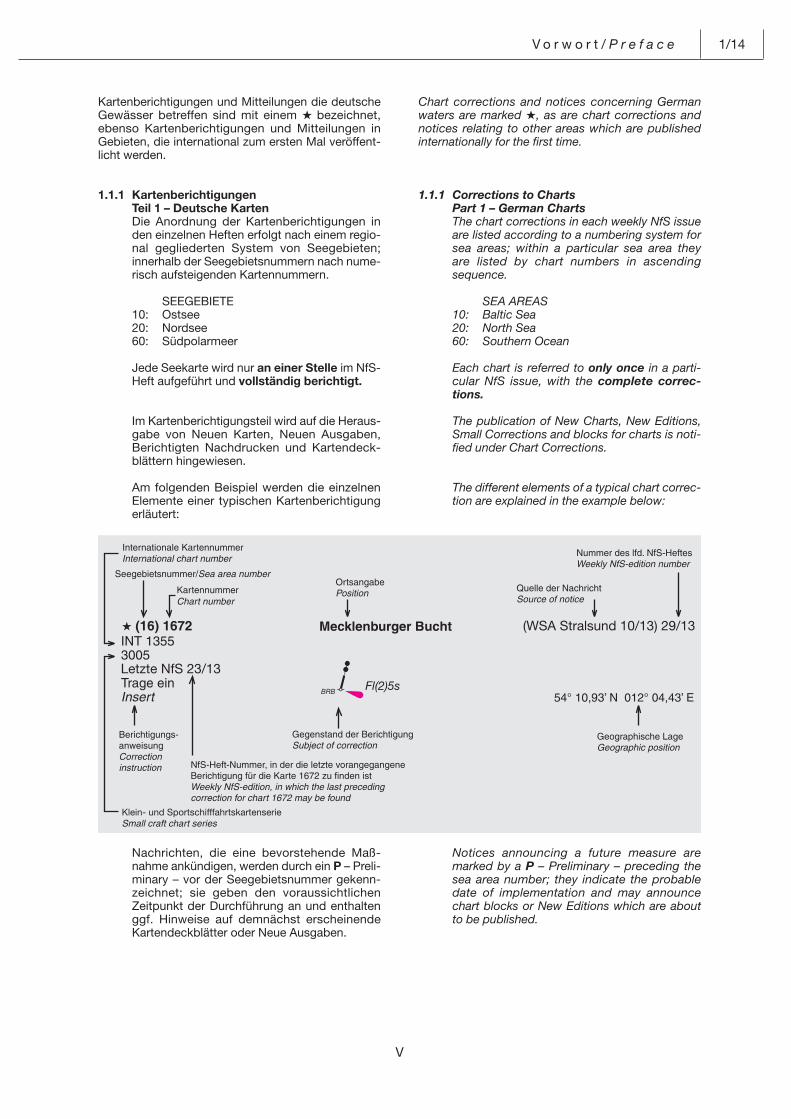
The different elements of a typical chart correc-tion are explained in the example below:
Kartenberichtigungen und Mitteilungen die deutsche Gewässer betreffen sind mit einem A bezeichnet, ebenso Kartenberichtigungen und Mitteilungen in Gebieten, die international zum ersten Mal veröffent-licht werden.
1.1.1 Kartenberichtigungen Teil 1 – Deutsche Karten Die Anordnung der Kartenberichtigungen in
den einzelnen Heften erfolgt nach einem regio-nal gegliederten System von Seegebieten; innerhalb der Seegebietsnummern nach nume-risch aufsteigenden Kartennummern.
SEEGEBIETE 10: Ostsee 20: Nordsee 60: Südpolarmeer
Jede Seekarte wird nur an einer Stelle im NfS-Heft aufgeführt und vollständig berichtigt.
Im Kartenberichtigungsteil wird auf die Heraus-gabe von Neuen Karten, Neuen Ausgaben, Berichtigten Nachdrucken und Kartendeck-blättern hingewiesen.
Am folgenden Beispiel werden die einzelnen Elemente einer typischen Kartenberichtigung erläutert:
Nachrichten, die eine bevorstehende Maß-nahme ankündigen, werden durch ein P – Preli-minary – vor der Seegebietsnummer gekenn-zeichnet; sie geben den voraussichtlichen Zeitpunkt der Durchführung an und enthalten ggf. Hinweise auf demnächst erscheinende Kartendeckblätter oder Neue Ausgaben.
Letzte NfS 23/13
(WSA Stralsund 10/13) 29/13
Klein- und Sportschifffahrtskartenserie
Notices announcing a future measure are marked by a P – Preliminary – preceding the sea area number; they indicate the probable date of implementation and may announce chart blocks or New Editions which are about to be published.
BRB Fl(2)5s
1/14 V o r w o r t / P r e f a c e
VI
Notices informing about a temporary measure are marked by a T – Temporary – preceding the sea area number. Temporary corrections to the Lfv. (List of Lights) or Shb. (Sailing Direc-tions) are not additionally published as chart corrections.
Because of the temporary nature of P- and T-corrections, BSH and distribution agents do not include them in the paper charts. Therefore, when using a navigational chart, the P- and T-corrections which are still in force must betaken into account.
Part 1 A – Admiralty Charts Chart corrections in Admiralty NtM are reprint-
ed according to the system of charted sea are-as shown in the enclosure to NfS issue 1 respectively 27.
1.1.2 Corrections to Sailing Directions Part 2 – German Sailing Directions Corrections to the Sailing Directions are printed
on one side of the paper in order that they may be cut up. Newly published books are indica-ted.
1.1.3 Corrections to Catalogue Part 3 – German Catalogue Changes in the latest edition of the Catalogue
of Nautical Charts and Books are published as catalogue corrections.
Listed are: – New Charts – New Editions – Small Corrections – Charts Withdrawn – New Editions Scheduled for Publication – New Books – Miscellaneous.
Part 3 A – British publications covering the area of the BSH’s charting responsibility
UKHO Notices to Mariners concerning New Editions of Admiralty charts and publications that are within the BSH’s area of charting responsibility are published as reprints in the German NfS.
1.1.4 Notifications Part 4 – Notifications (general) Information of common nautical interest that is
not to be used for the correction of nautical charts or other nautical publications is pub-lished under Notifications (general).
Part 4 A – Reprints of special Notifications Information provided by other Hydrographic
Offices that is of particular to navigation or marine environmental protection is published as reprints in this section.
Nachrichten, die über einen vorübergehenden (zeitweiligen) Zustand unterrichten, werden durch ein T – Temporary – vor der Seegebiets-nummer gekennzeichnet. Zeitweilige Berichti-gungen zum Lfv. oder Shb. werden nicht zusätzlich als Kartenberichtigung veröffentlicht.
P- und T-Berichtigungen werden wegen der begrenzten Geltungsdauer vom BSH und von den Vertriebs- und Auslieferungsstellen nicht in die Papierkarten eingearbeitet. Vor Gebrauch jeder Seekarte sind daher die noch gültigen P- und T-Berichtigungen zu berücksichtigen.
Teil 1 A – Britische Karten Die Abdrucke der britischen Kartenberichtigun-
gen nach den britischen NtM erfolgen ebenfalls nach dem System der Seegebiete, siehe Bei-lage Kartenliste zu NfS-Heft 1 bzw. 27.
1.1.2 Handbuchberichtigungen Teil 2 – Deutsche Seehandbücher Die Handbuchberichtigungen werden einseitig
gedruckt, so dass sie auch ausgeschnitten werden können. Auf neu erschienene Bücher wird hingewiesen.
1.1.3 Katalogberichtigungen Teil 3 – Deutscher Katalog Als Katalogberichtigungen werden die Verän-
derungen zur jeweils neuesten Ausgabe des Kataloges der Seekarten und Bücher veröffent-licht.
Aufgeführt werden: – Neue Karten – Neue Ausgaben – Berichtigte Nachdrucke – Eingezogene Karten – Beabsichtigte Neue Ausgaben – Neue Bücher – Sonstiges.
Teil 3 A – Britische Veröffentlichungen innerhalb des Bearbeitungs-gebietes des BSH
Für britische Veröffentlichungen innerhalb des Bearbeitungsgebietes des BSH werden Hin-weise auf Neuerscheinungen aus den briti-schen NtM als Abdrucke veröffentlicht.
1.1.4 Mitteilungen Teil 4 – Mitteilungen (normale) Als Mitteilungen werden Nachrichten veröffent-
licht, die nicht der Berichtigung der Seekarten oder anderer nautischer Veröffentlichungen dienen, aber doch als Information von nauti-schem Interesse sind.
Teil 4 A – Abdrucke besonderer Mitteilungen Besondere nautische Informationen, die für die
Schifffahrt oder für den Schutz der Meeresum-welt von großer Bedeutung sind, werden als Abdrucke von anderen Hydrographischen Diensten veröffentlicht.
VII
V o r w o r t / P r e f a c e 1/14
1.1.5 Enclosures NfS contain the following enclosures: – Corrections to the List of Lights (weekly)1
– List of P and T corrections in force (monthly)
– List of corrections and notifications (semian-nual)
– List of sea areas and charts relating to them (semiannual)
– German Ordinance on Requirements for the Entry of Vessels into German Internal Waters – (annual)
– Blocks for charts (as required)1 – and further enclosures as required.
1.1.6 Digitised Nachrichten für Seefahrer (NfS, notices to mariners) on the BSH homepage
The digitised Nachrichten für Seefahrer (NfS) on the BSH homepage are official publications for which a fee is charged, as for the printed NfS. Details will be announced on the BSH’s web pages.
Summaries of corrections to the navigational charts and publications issued by the BSH can be accessed on the BSH’s website. The sum-maries of corrections, which are free of charge, do not replace the official NfS.
Note: for true-to-scale reproductions of chart blocks (pdf files), the option “N o n e” has to be set for page scaling in the print dialogue window.
It is recommended that mariners take into ac-count the IMO “Guidelines for the on-board use and application of computers – MSC/Circ.891 of 21 December 1998”.
1.1.7 Notices to Mariners issued by other hydro-graphic services
The Notices to Mariners of other hydrographic services which are not taken into account by the BSH’s chart correction service can be accessed on the websites of the hydrographic services concerned. Links to those hydro-graphic services are provided on the BSH website under “Products”, by clicking on “Ocean charts” and website “International Hy-drographic Organization”.
1 Further copies can be obtained from BSH distribution agents
1.1.5 Beilagen Die NfS enthalten folgende Beilagen: – Deckblätter zur Berichtigung des Leucht-
feuerverzeichnisses (wöchentlich)1 – Liste der noch gültigen P- und T-Berichti-
gungen (monatlich) – Liste der Berichtigungen und Mitteilungen
(halbjährlich) – Liste der Seegebiete und der ihnen zuge-
ordneten Seekarten (halbjährlich) – Anlaufbedingungsverordnung (jährlich)
– Deckblätter zu den Seekarten (bei Bedarf)1 – sowie weitere Beilagen bei Bedarf.
1.1.6 Digitale Nachrichten für Seefahrer auf den Internetseiten des BSH
Die digitalen Nachrichten für Seefahrer (NfS) auf den Internetseiten des BSH sind als amt-liche Veröffentlichung anerkannt und wie die gedruckten NfS kostenpflichtig. Einzelheiten werden auf den Internetseiten des BSH be-kannt gegeben.
Die Klein- und Sportschifffahrt kann wie bisher den Berichtigungsservice (auch als Sammelbe-richtigungen bekannt) für die vom BSH heraus-gegebenen Seekarten und nautischen Veröf-fentlichungen verwenden. Diese kostenlos zur Verfügung gestellten Sammelberichtigungen ersetzen nicht die amtlichen NfS.
Hinweis: Zum maßstabsgetreuen Reproduzie-ren der Seekarten-Deckblätter (PDF-Files) ist darauf zu achten, dass im Dialogfenster „Drucken“ unter „Seitenanpassung“ die Option „k e i n e“ gewählt wird.
Der Schifffahrt wird empfohlen, die von der IMO angenommenen „Guidelines for the on-board use and application of Computers – MSC/Circ.891 vom 21. Dezember 1998“ zu beachten.
1.1.7 Nachrichten für Seefahrer anderer hydro-graphischer Dienste
Die Nachrichten für Seefahrer anderer hydro-graphischer Dienste, die nicht durch den Berichtigungsdienst des BSH berücksichtigt werden, sind auf den Internetseiten der jeweili-gen Dienste abrufbar. Die Links werden auf den Internetseiten des BSH unter dem Stichwort „Produkte“, „Seekarten“ und „International Hy-drographic Organization“ angeboten.
1 Weitere Exemplare können über die Vertriebsstellen des BSH bezogen werden
1/14 V o r w o r t / P r e f a c e
VIII
1.2 BEKANNTMACHUNGEN FÜR SEEFAHRER (BfS, Notifications to Mariners)
BfS are published by the responsible authori-ties of the Federal or State Waterways and Shipping Administration. They include all important measures and incidents on the national waterways and in the Exclusive Economic Zone of Germany.
Larger-scale measures or incidents, or meas-ures and occurrences beyond local importance, are published in the NfS.
BfS are posted at official stations and relate to the local sea area of the station and to adjacent regions as well as by website www.elwis.de. A list of the official poster sites is available at website www.bsh.de.
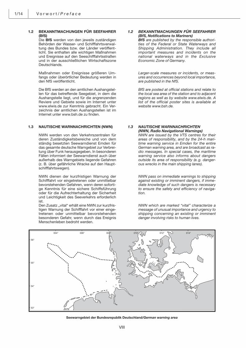
1.3 NAUTISCHE WARNNACHRICHTEN (NWN, Radio Navigational Warnings) NWN are issued by the VTS centres for their
areas of responsibility, and by the 24-h mari-time warning service in Emden for the entire German warning area, and are broadcast as ra-dio messages. In special cases, the maritime warning service also informs about dangers outside its area of responsibility (e. g. danger-ous wrecks in the main shipping lanes).
NWN pass on immediate warnings to shipping against existing or imminent dangers, if imme-diate knowledge of such dangers is necessary to ensure the safety and efficiency of naviga-tion.
NWN which are marked “vital” characterize a message of unusual importance and urgency to shipping concerning an existing or imminent danger involving risks to human lives.
1.2 BEKANNTMACHUNGEN FÜR SEEFAHRER (BfS)
Die BfS werden von den jeweils zuständigen Behörden der Wasser- und Schifffahrtsverwal-tung des Bundes bzw. der Länder veröffent-licht. Sie enthalten alle wichtigen Maßnahmen und Ereignisse auf den Seeschifffahrtsstraßen und in der ausschließlichen Wirtschaftszone Deutschlands.
Maßnahmen oder Ereignisse größeren Um-fangs oder überörtlicher Bedeutung werden in den NfS veröffentlicht.
Die BfS werden an den amtlichen Aushangstel-len für das betreffende Seegebiet, in dem die Aushangstelle liegt, und für die angrenzenden Reviere und Gebiete sowie im Internet unter www.elwis.de zur Kenntnis gebracht. Ein Ver-zeichnis der amtlichen Aushangstellen ist im Internet unter www.bsh.de zu finden.
1.3 NAUTISCHE WARNNACHRICHTEN (NWN)
NWN werden von den Verkehrszentralen für deren Zuständigkeitsbereiche und von dem ständig besetzten Seewarndienst Emden für das gesamte deutsche Warngebiet zur Verbrei-tung über Funk herausgegeben. In besonderen Fällen informiert der Seewarndienst auch über außerhalb des Warngebiets liegende Gefahren (z. B. über gefährliche Wracke auf den Haupt-schifffahrtswegen).
NWN dienen der kurzfristigen Warnung der Schifffahrt vor eingetretenen oder unmittelbar bevorstehenden Gefahren, wenn deren soforti-ge Kenntnis für eine sichere Schiffsführung oder für die Aufrechterhaltung der Sicherheit und Leichtigkeit des Seeverkehrs erforderlich ist.
Den Zusatz „vital“ erhält eine NWN zur kurzfris-tigen Warnung der Schifffahrt vor einer einge-tretenen oder unmittelbar bevorstehenden besonderen Gefahr, wenn durch das Ereignis Menschenleben bedroht werden.
���
���
���
���
���� ���� ���� ��� �� ���
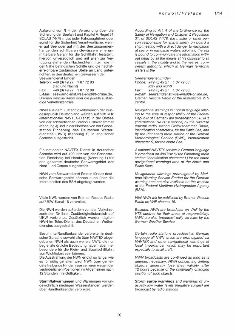
Seewarngebiet der Bundesrepublik Deutschland/German warning area
IX
V o r w o r t / P r e f a c e 1/14
According to Art. 4 of the Ordinance for the Safety of Navigation and Chapter V, Regulation 31, of SOLAS 74/78, the master or other per-son responsible for ship’s safety on board a ship meeting with a direct danger to navigation at sea or in navigable waters adjoining the sea is bound to communicate the information with-out delay by all the means at his disposal to all vessels in the vicinity and to the nearest com-petent authority, which in German territorial waters is the
Seewarndienst Emden Phone: +49 (0) 49 27 1 87 72 83 (day and night) Fax: +49 (0) 49 27 1 87 72 88 e-mail: [email protected], Bremen Rescue Radio or the responsible VTS
centre.
Navigational warnings in English language relat-ing to the area of responsibility of the Federal Republic of Germany are broadcast on 518 kHz (international NAVTEX service) by the Swedish coastal radio station Gislövshammar Radio, identification character J, for the Baltic Sea, and by the Pinneberg radio station of the German Meteorological Service (DWD), identification character S, for the North Sea.
A national NAVTEX service in German language is broadcast on 490 kHz by the Pinneberg radio station (identification character L) for the entire navigational warnings area of the North and Baltic Seas.
Navigational warnings promulgated by Mari-time Warning Service Emden for the German warning area are also available on the website of the Federal Maritime Hydrographic Agency (BSH).
Vital NWN will be published by Bremen Rescue Radio on VHF channel 16.
Besides, NWN are broadcast on VHF by the VTS centres for their areas of responsibility. NWN are also broadcast daily via telex by the German Weather Service.
Certain radio stations broadcast in German language all NWN which are promulgated via NAVTEX and other navigational warnings of local importance, which may be important especially to small craft.
NWN broadcasts are continued as long as is deemed necessary. NWN concerning drifting objects generally lose their validity after 12 hours because of the continually changing position of such objects.
Storm surge warnings and warnings of un-usually low water levels (negative surges) are broadcast by radio stations.
Aufgrund von § 4 der Verordnung über die Sicherung der Seefahrt und Kapitel V, Regel 31 SOLAS 74/78 muss jeder Fahrzeugführer oder sonst für die Sicherheit Verantwortliche, wenn er auf See oder auf mit der See zusammen-hängenden schiffbaren Gewässern eine un-mittelbare Gefahr für die Schifffahrt feststellt, hiervon unverzüglich und mit allen zur Ver-fügung stehenden Nachrichtenmitteln die in der Nähe befindlichen Schiffe und die nächst-erreichbare zuständige Stelle an Land unter-richten, in den deutschen Gewässern den
Seewarndienst Emden Telefon: +49 (0) 49 27 1 87 72 83 (Tag und Nacht) Fax: +49 (0) 49 27 1 87 72 88 E-Mail: [email protected], Bremen Rescue Radio oder die jeweils zustän-
dige Verkehrszentrale.
NWN aus dem Zuständigkeitsbereich der Bun-desrepublik Deutschland werden auf 518 kHz (internationaler NAVTEX-Dienst) in der Ostsee von der schwedischen Station Gislövshammar (Kennung J) und in der Nordsee von der Sende-station Pinneberg des Deutschen Wetter-dienstes (DWD) (Kennung S) in englischer Sprache ausgestrahlt.
Ein nationaler NAVTEX-Dienst in deutscher Sprache wird auf 490 kHz von der Sendesta-tion Pinneberg bei Hamburg (Kennung L) für das gesamte deutsche Seewarngebiet der Nord- und Ostsee ausgestrahlt.
NWN vom Seewarndienst Emden für das deut-sche Seewarngebiet können auch über die Internetseiten des BSH abgefragt werden.
Vitale NWN werden von Bremen Rescue Radio auf UKW-Kanal 16 verbreitet.
Die NWN werden außerdem von den Verkehrs-zentralen für ihren Zuständigkeitsbereich auf UKW verbreitet. Zusätzlich werden täglich NWN im Telex-Dienst des Deutschen Wetter-dienstes ausgestrahlt.
Bestimmte Rundfunksender verbreiten in deut-scher Sprache sowohl alle über NAVTEX abge-gebenen NWN als auch weitere NWN, die nur begrenzte örtliche Bedeutung haben, aber ins-besondere für die Klein- und Sportschifffahrt von Wichtigkeit sein können.
Die Ausstrahlung der NWN erfolgt so lange, wie es für nötig gehalten wird. NWN über gemel-dete treibende Hindernisse verlieren wegen der veränderlichen Positionen im Allgemeinen nach 12 Stunden ihre Gültigkeit.
Sturmflutwarnungen und Warnungen vor un-gewöhnlich niedrigen Wasserständen wer den über Rundfunksender verbreitet.
1/14 V o r w o r t / P r e f a c e
X
Traffic information on VHF is broadcast at routine times by VTS centres in German and partly in English language. These broadcasts contain navigational warnings for the particular area as well as information on traffic, tides, visibility, ice conditions, casualties to seamarks, shipping obstructions and special incidents.
1.4 “HAVARIEKOMMANDO – HK” (CENTRAL COMMAND FOR MARITIME EMERGENCIES GERMANY – CCME) AND “MARITIMES LAGEZENTRUM – MLZ” (MARITIME EMER-GENCY REPORTING AND ASSESSMENT CENTRE – MERAC).
In January 2003, the federal government and the German coastal states jointly established the “Havariekommando” (Central Command for Maritime Emergencies – CCME) in Cuxhaven, whose task was to develop and implement a jointly operated marine casualty management system for the North Sea and Baltic Sea. The Central Command for Maritime Emergen-cies (CCME) with the Maritime Emergency Reporting and Assessment Centre (MERAC) deals with complex marine casualties off the German coast and is responsible for planning, preparing, and implementing measures to save injured persons, combat pollution, fight fires, provide technical assistance, and carry out salvage operations in order to combat hazards.
MERAC is Germany’s national and international reporting centre for marine casualties.
Its tasks include – operation of the reporting centre for marine
casualties and marine pollution in its capa-city as the notified National Contact Point in Germany;
– operation of the central reporting system of the Federal Republic of Germany for hazard-ous and noxious goods carried on sea and shipping (ZMGS) in connection with the Eu-ropean Community vessel traffic monitoring and information system SafeSeaNet;
– continuous IT-supported monitoring of the maritime situation.
If MERAC receives a report on a casualty which it considers to be a major marine casualty or major marine pollution requiring coordinated deployment of all available equipment, it will summon the “Havariestab” coordinating unit. The “Havariestab” is in charge of coordinating the required rescue and salvage operations.
MERAC is on duty 24 hours a day: Phone: +49 (0) 47 21 56 74 85 56 74 99 (ZMGS) Fax: +49 (0) 47 21 55 47 44 55 47 45 e-mail: [email protected]
Verkehrsinformationen auf UKW werden zu festen Zeiten von Verkehrszentralen in deut-scher und zum Teil in englischer Sprache verbreitet. Die Meldungen enthalten für den jeweiligen Bereich nautische Warnnachrichten sowie Angaben über Verkehrs-, Tide-, Sicht-, ggf. Eisverhältnisse, Störungen an Schifffahrts-zeichen, Schifffahrtshindernisse und beson-dere Vorkommnisse.
1.4 HAVARIEKOMMANDO (HK) UND MARITIMES LAGEZENTRUM (MLZ).
Zum Aufbau und zur Durchführung eines ge-meinsamen Unfallmanagements für Nord- und Ostsee haben der Bund und die Küstenländer im Januar 2003 das „Havariekommando als Gemeinsame Einrichtung des Bundes und der Küstenländer“ mit Sitz in Cuxhaven gegründet. Das Havariekommando (HK) mit dem Mari-timen Lagezentrum ist bei komplexen Schadenslagen vor deutschen Küsten verant-wortlich für die Planung, Vorbereitung und Durchführung von Maßnahmen zur Verletzten-versorgung, zur Schadstoffunfallbekämpfung, zur Brandbekämpfung, zur technischen Hilfe-leistung sowie zur gefahrenabwehrbezogenen Bergung verbunden mit einer strukturierten Öffentlichkeitsarbeit.
Das Maritime Lagezentrum (MLZ) ist die nationale und internationale Meldestelle der Bundesrepublik Deutschland für Unfälle auf See.
Dem MLZ obliegen u. a. das – Betreiben der Meldestelle für Seeunfälle und
Meeresverschmutzungen als für Deutschland benannter National Contact Point,
– Betreiben des Zentralen Meldesystems für Gefahrgut und Schiffsverkehre der Bundes-republik Deutschland (ZMGS) in Verbindung mit dem gemeinschaftlichen europäischen Überwachungs- und Informationssystem für den Schiffsverkehr SafeSeaNet,
– ständige Führen eines IT-unterstützten Mari-timen Lagebildes.
Erkennt das MLZ bei einer Unfallmeldung, dass es sich um einen schweren Schiffsunfall oder eine schwerwiegende Meeresverschmutzung handelt, die einen koordinierten Einsatz aller Hilfsmittel verlangen, so veranlasst es die Ein-berufung des Havariestabes. Der Havariestab koordiniert dann alle notwendigen Hilfs- und Rettungsmaßnahmen.
Das MLZ ist Tag und Nacht erreichbar: Telefon: +49 (0) 47 21 56 74 85 56 74 99 (ZMGS) Fax: +49 (0) 47 21 55 47 44 55 47 45 E-Mail: [email protected]
XI
V o r w o r t / P r e f a c e 1/14
Shipping is requested to inform MERAC of any marine pollution observed. Such observations should be reported using the MARPOL report-ing format. It ensures quick recording, evalua-tion, and transmission of the report. The infor-mation should be provided in the same sequence and under the letters given in the schedule and should be as complete as possi-ble. Also radio reports to a VTS-Centre should follow this pattern.
MARPOL reporting format for marine pollu-tion by oil and other contaminants, see “Hand-buch für Brücke und Kartenhaus” (section 9.5).
Competent Authority at MERAC
The Competent Authority (Zentrale Melde-stelle) at MERAC operates the federal portal www.zmgs.de, which is the address for ships’ reports required under the „Anlaufbedingungs-verordnung1“ (AnlBV).
Alternatively, required reports can be transmit-ted to the following port authorities and port information systems:
1. Reports required to be made under items 2.1.1 and 2.1.2 of the Annex to Art. 1, AnlBV.
To comply with the reporting requirement, reports can be transmitted to the following port authorities or port information systems:
1 Ordinance on the requirements for vessels entering the internal waters of the Federal Republic of Germany from sea areas seaward of the delimitation of the German territorial sea and for vessels lea-ving such internal waters, 18 February 2004 (BGBl. I, p. 300, last amended by Art. 7 of the Ordinance of 8 March 2012 (BGBl. I,p. 483).
Die Schifffahrt wird gebeten, das MLZ über Meeresverschmutzungen zu unterrichten. Für eine solche Meldung soll das MARPOL-Melde-schema verwendet werden. Es dient der schnellen Erfassung, Auswertung und Weiter-gabe der Meldung. Die Angaben zur Sache sol-len in der vorgegebenen Reihenfolge möglichst vollständig und unbedingt unter Verwendung der jeweiligen Buchstaben erfolgen. Auch bei Meldungen über Funk an eine Verkehrszentrale soll dies möglichst berücksichtigt werden.
MARPOL-Meldeschema bei Gewässerverun-reinigungen durch Öl oder andere Schadstoffe siehe Handbuch für Brücke und Kartenhaus (Abschnitt 9.5).
Zentrale Meldestelle im Maritimen Lagezen-trum des Havariekommandos
Die Zentrale Meldestelle im Maritimen Lage-zentrum des Havariekommandos betreibt zur Annahme der erforderlichen Meldungen nach Anlaufbedingungsverordnung1 (AnlBV) das Bundesportal www.zmgs.de.
Alternativ besteht für die Verpflichteten auch die Möglichkeit der Meldung mit befreiender Wirkung über die nachfolgend bekannt ge-machten Hafenbehörden und Hafeninforma-tionssysteme:
1. Für Meldepflichten gemäß den Nummern 2.1.1 und 2.1.2 der Anlage zu § 1 Absatz 1 AnlBV.
Die Meldepflicht wird mit einer Meldung an fol-gende Hafenbehörden bzw. Hafeninforma-tionssysteme erfüllt:
1 Verordnung über das Anlaufen der inneren Gewässer der Bundes-republik Deutschland aus Seegebieten seewärts der Grenze des deutschen Küstenmeers und das Auslaufen (Anlaufbedingungs-verordnung) vom 18. Februar 2004 (BGBl. I S. 300, zuletzt geän-dert durch Artikel 7 der Verordnung vom 8. März 2012 (BGBl. I S. 483).
Hafenname Hafenbehörde/HafeninformationssystemPort Name Port Authority/Port Information System
Hamburg Hamburg Port Authority HPA Neuer Wandrahm 4 20457 Hamburg Telefon: +49 (0) 40 4 28 47-0 Fax: +49 (0) 40 4 28 47-28 81 E-Mail: [email protected]
Bremen dbh Logistics IT AGBremerhaven Martinistraße 47–49 28195 Bremen Telefon: +49 (0) 4 21 3 09 02-01 Fax: +49 (0) 4 21 3 09 02-57 E-Mail: [email protected]
Greifswald DATEN + DIENSTE GmbH RostockMukran Lange Str. 1aRostock (Warnemünde) 18055 RostockSassnitz, Stralsund Telefon: +49 (0) 3 81 81 70-48 00Ueckermünde, Vierow Fax: +49 (0) 3 81 81 70-48 03Wismar, Wolgast E-Mail: [email protected]
1/14 V o r w o r t / P r e f a c e
XII
Brunsbüttel-Elbehafen HafeninformationssystemeBrunsbüttel-Ölhafen Schleswig-HolsteinBrunsbüttel-Hafen DATEN + DIENSTE GmbH RostockOstermoor Lange Str. 1aBüsum 18055 RostockGlückstadt-Außenhafen Telefon: + 49 (0) 3 81 81 70-48 00 Husum Fax: + 49 (0) 3 81 81 70-48 03 E-Mail: [email protected]
Cuxhaven Niedersachsen Ports GmbH & Co. KG2
Stade Hindenburgstraße 26–30Brake 26122 OldenburgEmden Telefon: + 49 (0) 4 41 7 99-22 57Wilhelmshaven Fax: + 49 (0) 4 41 7 99-22 52 E-Mail: [email protected]
Des Weiteren wird die Meldepflicht mit einer Direktmeldung an folgendes Hafeninforma-tionssystem erfüllt:
2. Für die Meldepflicht gemäß der Nummer 2.2.1 der Anlage zu § 1 Absatz 1 AnlBV.
Die Meldepflicht wird mit einer Meldung an eines der folgenden Hafeninformationssysteme erfüllt:
Weitere Informationen zum Zugang zu ZMGS erhalten Sie durch das:
1
2 Versand der Anmeldedaten an ZMGS erfolgt über FirmaTraDaV GmbH
The reporting requirement is also met by reporting directly to the following port informa-tion system:
2. Reports required to be made under item 2.2.1 of the Annex to Art. 1, para 1, AnlBV.
To comply with the reporting requirement, reports can be transmitted to one of the follow-ing port information systems:
Additional information regarding ZMGS access is available at:
1
2 User’s credentials will be delivered to ZMGS by company TraDaV GmbH
HavariekommandoGemeinsame Einrichtung des Bundes und der KüstenländerMaritimes LagezentrumAm Alten Hafen 227472 CuxhavenTelefon: +49 (0) 47 21 5 67-4 99E-Mail: [email protected]
Firma TraDaV GmbHSeelandstraße 323569 LübeckTelefon: +49 (0) 4 51 39 09-4 17Fax: +49 (0) 4 51 39 09-4 99E-Mail: [email protected]
DAKOSY Datenkommunikationssystem AG dbh Logistics IT AGMattentwiete 2 Martinistraße 47–4920457 Hamburg 28195 BremenTelefon: +49 (0) 40 3 70 03-0 Telefon: +49 (0) 4 21 3 09 02-01Fax: +49 (0) 40 3 70 03-3 70 Fax: +49 (0) 4 21 3 09 02-57E-Mail: [email protected] E-Mail: [email protected]
DATEN + Dienste GmbH Firma TraDaV GmbHLange Str. 1a Seelandstraße 318055 Rostock 23569 LübeckTelefon: +49 (0) 3 81 81 70-48 00 Telefon: +49 (0) 4 51 39 09-4 17Fax: +49 (0) 3 81 81 70-48 03 Fax: +49 (0) 4 51 39 09-4 99E-Mail: [email protected] E-Mail: [email protected]
XIII
V o r w o r t / P r e f a c e 1/14
1.5 MARITIME RESCUE COORDINATION CENTRE (MRCC) BREMEN – ASSISTANCE IN CASE OF MARINE CASUALTIES AT SEA
The purpose of the International Convention on Maritime Search and Rescue is to ensure that in case of marine casualties the responsible RCC (Rescue Coordination Centre) provides support and assistance and assumes a coordi-nating function. For the German search and rescue region, this task has been assigned to Deutsche Gesellschaft zur Rettung Schiff-brüchiger (DGzRS, German Sea-Rescue Service).
In cases of marine casualties outside the German search and rescue region where it proves impossible to contact the responsible local MRCC/RCC, MRCC Bremen may be contacted who will then in assisting the vessel in distress try to get in touch with the respon-sible MRCC/RCC.
MRCC Bremen will, upon request, also assist foreign MRCCs/RCCs in their efforts to coordi-nate SAR-measures for German vessels in dis-tress in foreign sea areas.
MRCC Bremen is constantly manned.
Phone: +49 (0) 4 21 5 36 87-0 Fax: +49 (0) 4 21 5 36 87 14 Cellular phone: 124 124 (direct call within the coverage of German providers)
VHF: channel 16 (call: Bremen Rescue Radio) channel 70 (MMSI 00 211 1240) Telex: +41 246 466 MRCC D e-mail: [email protected]
(not for distress alerting)
Please refer to International Aeronautical and Maritime Search and Rescue Manual (IAMSAR Manual), Volume III – Mobile Facilities.
2 Nautical Publications according
to the Schiffssicherheitsverord-
nung (Ordinance for the Safety
of Seagoing Ships)
The purpose of the Schiffssicherheitsgesetz (SchSG, Ship Safety Act) of 9 September 1998 (Federal Law Gazette I, p. 2860), last amended by Art. 4 of the Act of 4 June 2013 (Federal Law Gazette I, p. 1471) is to achieve uniform and effective implementation of the valid interna-tional regulations aimed at ensuring the safety of seagoing vessels (including protection of the safety and health of persons employed on board seagoing vessels) and protecting the marine environment. It applies to all seagoing vessels with the exception of ships of the Ger-man armed forces and the German Maritime
1.5 SEENOTLEITUNG (MRCC) BREMEN – UNTERSTÜTZUNG BEI UNGLÜCKSFÄLLEN AUF SEE.
Das Internationale Übereinkommen von 1979 über den Such- und Rettungsdienst auf See soll sicherstellen, dass bei Unglücksfällen auf See Rettung, Unterstützung und eine entspre-chende Koordinierung durch ein RCC (Rescue Coordination Centre) gewährleistet sind. Für das deutsche Such- und Rettungsgebiet wurden diese Aufgaben der Deutschen Gesell-schaft zur Rettung Schiffbrüchiger (DGzRS) übertragen.
Falls bei einem Notfall auf See außerhalb des deutschen Such- und Rettungsgebietes eine Verbindung mit dem dort zuständigen MRCC/RCC nicht zustande kommt, kann die Seenot-leitung (MRCC) Bremen um Hilfe gebeten werden, die dann ihrerseits versucht, mit dem zuständigen MRCC/RCC Verbindung aufzu-nehmen.
Außerdem gewährt die Seenotleitung (MRCC) Bremen auf Anforderung auch Unterstützung für ausländische MRCC/RCC bei deren Koordi-nierung von SAR-Maßnahmen für deutsche Schiffe in fremden Seegebieten.
Die Seenotleitung (MRCC) Bremen ist ständig erreichbar.
Telefon: +49 (0) 4 21 5 36 87-0 Fax: +49 (0) 4 21 5 36 87 14 Mobiltelefon: 124 124 (Direktwahl im Abdeckungs- bereich der deutschen Netzbetreiber) UKW: Kanal 16 (Ruf: Bremen Rescue Radio) Kanal 70 (MMSI 00 211 1240)
Telex: +41 246 466 MRCC D E-Mail: [email protected] (nicht zur Alarmierung)
Auf das Internationale Handbuch für die luftge-stützte und maritime Suche und Rettung (IAM-SAR Manual), Volume III – Mobile Facilities, wird hingewiesen.
2 Nautische Veröffentlichungen
nach der Schiffssicherheitsver-
ordnung
Das Schiffssicherheitsgesetz (SchSG) vom 9. September 1998 (BGBl. I S. 2860); zuletzt geändert durch Artikel 4 des Gesetzes vom 4. Juni 2013 (BGBl. I S. 1471) dient der einheit-lichen und wirksamen Durchführung der gel-tenden internationalen Schiffssicherheitsrege-lungen zur Gewährleistung der Sicherheit auf See (einschließlich des damit unmittelbar im Zusammenhang stehenden Arbeitsschutzes von Beschäftigten auf Seeschiffen) und des Umweltschutzes auf See. Es gilt für die ge-samte Seefahrt mit Ausnahme der Schiffe der Bundeswehr und der Deutschen Gesellschaft
1/14 V o r w o r t / P r e f a c e
XIV
SAR-Service as well as ships which fly foreign flags and which are used exclusively in the service of foreign states for purposes other than commercial shipping.
The regulations of SchSG apply to vessels fly-ing the German flag and to inland waterway vessels listed in a German Ship’s Register.
They also apply to foreign flag vessels and for-eign inland waterway vessels engaged in coastal shipping as defined in the Ordinance on coastal shipping (Verordnung über die Küstenschiff-fahrt) of 5 July 2002 (Federal Law Gazette I, p. 2555) in the version currently in force or which are used commercially on navigable waterways or in the part of the German territorial sea sea-wards thereof.
According to Art. 7, SchSG, it is the vessel owner’s responsibility that the vessel carries the required official nautical charts and books as well as other publications. Under Art. 9, SchSG, not only the vessel’s owner is reponsi-ble but also her master and other persons in charge of the vessel’s safety.
Art. 2 of the Schiffssicherheitsverordnung (SchSV, Ordinance for the Safety of Seagoing Ships) of 18 September 1998 (Federal Law Ga-zette I, p. 3013, 3023), last amended by Art. 2 § 11 of the Ordinance of 20 December 2012 (Federal Law Gazette I, p. 2802) deals with the principle of self-monitoring as follows:
“Whoever operates a vessel in maritime service shall ensure that any hazards identified during her operation are investigated, and that any in-formation gained during the vessel’s operation as well as any other relevant information and documents, including records kept by the per-sons in charge of navigating the vessel, are evaluated as a precautionary safety measure and that all measures required for risk avoid-ance or minimization are taken.”
The catalogue of duties, under Art. 13, para. 1, no. 2 SchSV, also provides that the official nau-tical charts and books required for a particular voyage as well as the NfS issued by the BSH must be available on the bridge upon the ves-sel’s departure. In part C.I.4. no. 3 of Annex 1 to Art. 5 SchSV, which refers to chapter V of the Annex to SOLAS 74/78 (Regulation 2 para. 2, Regulation 19 para 2.1.4 and Regulation 27), defines official nautical publications as follows: vessels not defined as small craft according to Sportbootführerscheinverordnung-See (ordi-nance on small craft licenses, offshore) are re-quired to carry the nautical charts, books, and other publications in printed or digital format officially issued by the BSH or by a foreign hy-drographic service.
zur Rettung Schiffbrüchiger sowie der Schiffe unter ausländischer Flagge, die im Dienst auslän discher Staaten ausschließlich für ande-re als Handelszwecke genutzt werden.
Die Vorschriften des SchSG sind auf Schiffe anzuwenden, die die Bundesflagge führen oder als Binnenschiffe in einem deutschen Schiffs-register eingetragen sind.
Sie sind auch auf Schiffe unter ausländischer Flagge und ausländische Binnenschiffe anzu-wenden, mit denen Küstenschifffahrt im Sinne der Verordnung über die Küstenschifffahrt vom 5. Juli 2002 (BGBl. I S. 2555) in ihrer jeweils geltenden Fassung betrieben wird oder die auf Seeschifffahrtsstraßen oder im seewärts an-grenzenden Bereich des deutschen Küsten-meeres gewerblich eingesetzt sind.
Nach § 7 SchSG ist der Schiffseigentümer für die Ausrüstung des Schiffes mit den erforder-lichen amtlichen Seekarten, Seebüchern und sonstigen Veröffentlichungen verantwortlich. Neben dem Schiffseigentümer sind nach § 9 SchSG sowohl der Schiffsführer als auch Per-sonen, die mit den Aufgaben der Sicherheit des Schiffes beauftragt sind, verantwortlich.
Die Schiffssicherheitsverordnung (SchSV) vom 18. September 1998 (BGBl. I S. 3013, 3023), zuletzt geändert durch Artikel 2 § 11 der Ver-ordnung vom 20. Dezember 2012 (BGBl. I S. 2802), regelt im § 2 den Grundsatz der Selbstkontrolle:
„Wer ein Schiff zur Seefahrt einsetzt, hat dafür zu sorgen, dass im Schiffsbetrieb auftretende Gefahrenquellen überprüft, im Betrieb gewon-nene Erkenntnisse sowie andere wichtige hier-zu zur Verfügung stehende Informationen und Unterlagen einschließlich der Aufzeichnungen der mit der Bedienung des Schiffes beauftrag-ten Personen im Rahmen der Sicherheitsvor-sorge ausgewertet und die zur Gefahrenver-meidung und -verminderung erforderlichen Maßnahmen getroffen werden.“
Außerdem sieht der Katalog der Verhaltens-pflichten in § 13 Abs. 1 Nr. 2 der SchSV u. a. vor, dass auf der Brücke stets die für die jewei-lige Seereise erforderlichen amtlichen Ausga-ben von Seekarten und Seebüchern sowie die vom BSH herausgegebenen NfS bei Reisean-tritt vorhanden sein müssen. In Abschnitt C.I.4. Nr. 3 der Anlage 1 zu § 5 SchSV sind zu Kapitel V der Anlage zu SOLAS 74/78 (Regel 2 Abs. 2, Regel 19 Abs. 2.1.4, Regel 27) amtliche Veröf-fentlichungen wie folgt definiert: Bei Schiffen, die nicht Sportboote im Sinne der Sportboot-führerscheinverordnung-See sind, müssen hin-sichtlich der Seekarten und anderen nautischen Veröffentlichungen jeweils die neuesten amt-lichen Ausgaben des BSH in digitaler oder ge-druckter Form oder eine entsprechende Aus-gabe eines hydrographischen Dienstes eines anderen Staates oder der Internationalen See-schifffahrtsorganisation mitgeführt werden.
XV
V o r w o r t / P r e f a c e 1/14
New editions of the official nautical maps of the BSH are the printed and digital nautical maps which are published in the NfS, for which cor-rections are published in the NfS or for which an official digital correction service exists and which are certified by a stamp or electronic sig-nature are being up to date at the time of publi-cation. Official nautical books of the BSH are those oriented and digital books listed in the inventory of the BSH, for which corrections are published in the NfS or for which an official dig-ital correction service exists.
According to Art. 13 para. 1 sentence 2 lit. c) SchSV, every vessel must carry the NfS of the current year and of the two preceding years. Ships operating in the tidal flats areas and in coastal fisheries are not required to carry the German Notices to Mariners provided that they have been consulted before leaving port.
Up-to-date official nautical charts in printed or digital format are those listed in the cata-logue of BSH which are kept corrected by the German NfS or by an official digital correction service and which, upon publication, carry a note in printed or digital format confirming that they have been fully corrected.
Official nautical books in printed or digital for-mat are those which are listed in the catalogue of BSH and are kept corrected by the BSH or by an official digital correction service, e. g. Sailing Directions, List of Lights, List of Radio Signals, Standard Marine Navigational Vocabu-lary, International Aeronautical and Maritime Search and Rescue Manual (IAMSAR Manual), International Code of Signals, Nautical Alma-nac, Tide Tables, Handbuch für Brücke und Kartenhaus (bridge and charthouse manual). The official nautical publications also include other books officially designated as such by the Federal Ministry of Transport and Digital Infra-structur (ship safety requirements and hand-book), as well as nautical publications issued by foreign hydrographic services.
The owner of a vessel whoeither willfully or by negligence, fails to ensure that the required nautical documents are available on the ves-sel’s bridge commits an administrative offence according to Art. 14 para. 1 no. 1 lit. b) SchSV in conjunction with Art. 13 para. 1 no. 2 SchSV.
Neueste Ausgaben der amtlichen Seekarten des BSH sind die in dem in den Nachrichten für Seefahrer veröffentlichten Verzeichnisse des BSH aufgeführten digitalen und gedruckten Seekarten, für die in den Nachrichten für See-fahrer Berichtigungen veröffentlicht werden oder für die ein amtlicher digitaler Berichti-gungsdienst besteht und die in dem Zeitpunkt, in dem sie in Verkehr gebracht werden, mittels eines Aufdrucks oder einer elektronischen Sig-natur als auf den neuesten Stand berichtigt ausgewiesen sind. Amtliche Seebücher des BSH sind die in dem Verzeichnis des BSH auf-geführten gedruckten und digitalen Bücher, für die in den Nachrichten für Seefahrer Berich-tigungen veröffentlicht werden oder ein amt-licher digitaler Berichtigungsdienst besteht.
Gemäß § 13 Abs. 1 Satz 2 Buchst. c) SchSV muss jedes Schiff die Nachrichten für See-fahrer des laufenden und der zwei vorange-gangenen Jahre an Bord haben. Auf Schiffen in der Wattfahrt und in der Küstenfischerei brau-chen die NfS nicht an Bord zu sein, wenn diese vor dem Auslaufen eingesehen werden.
Neueste Ausgaben der amtlichen Seekarten des Bundeamtes für Seeschifffahrt und Hydro-graphie sind die in den NfS veröffentlichten und im Katalog des Bundesamtes für Seeschifffahrt und Hydrographie aufgeführten digitalen und gedruckten Seekarten, für die in den NfS Be-richtigungen veröffentlicht werden oder ein amtlicher digitaler Berichtigungsdienst besteht und die zu dem Zeitpunkt, in dem sie in Verkehr gebracht werden, mittels eines Aufdrucks oder einer elektronischen Signatur als auf den letz-ten Stand berichtigt ausgewiesen sind.
Amtliche Seebücher sind die im Katalog des BSH aufgeführten gedruckten und digitalen Bücher, für die vom BSH Berichtigungen veröf-fentlicht werden oder ein amtlicher digitaler Be-richtigungsdienst besteht, wie Seehandbücher, Leuchtfeuer verzeichnisse, Handbuch Nauti-scher Funkdienst, Handbuch Revierfunkdienst, IMO-Standardredewendungen, International Aeronautical and Maritime Search and Rescue Manual (IAMSAR Manual), Internationales Sig-nalbuch, Nautisches Jahrbuch, Gezeitentafeln, Handbuch für Brücke und Kartenhaus. Amt-liche Seebücher sind ferner sonstige vom Bundesministerium für Verkehr und digitale Infrastruktur als solche bestimmte Bücher(Schiffssicherheitsvorschriften, Schiffssicher-heitshandbuch) sowie Seebücher hydrographi-scher Dienste anderer Staaten.
Wer als Eigentümer vorsätzlich oder fahrlässig nicht dafür sorgt, dass sich die vorgeschriebe-nen nautischen Unterlagen auf der Brücke be-finden begeht eine Ordnungswidrigkeit nach § 14 Abs. 1 Nr. 1 Buchst. b) SchSV in Verbin-dung mit § 13 Abs. 1 Nr. 2 SchSV.
1/14 V o r w o r t / P r e f a c e
XVI
3 Official Nautical Charts and
Books
The official nautical charts and books of the Federal Republic of Germany are issued by the BSH under Art. 1 para. 10 of the Federal Maritime Responsibilities Act (Seeaufgabenge-setz, SeeAufgG). They are kept corrected by the German NfS.
However, information might be provided to the BSH late, incomplete, or faulty, or no informa-tion may be available at all, particularly from sea areas with little vessel traffic or countries with a less developed shipping organization. There-fore, the BSH does not accept liability for the correctness of all data; rather, the possi-bility that data may be incorrect should always be taken into acount in navigation. That applies also to rules and regulations quoted in the nau-tical books. In the event that contradictory in-formation is provided in different publications, navigation should be based on the least favour-able data.
Official nautical charts and books issued by foreign Hydrographic Offices.
The BSH fulfills its legal obligation concerning the safety and efficiency of navigation and pre-vention of hazards to shipping by issuing a comprehensive information system which com-prises nautical charts and publications covering the most important continental European har-bour approaches in the North and Baltic Sea. For sea areas which are not covered by this informa tion system or for which German charts of a suitable scale are not available, the official charts of foreign Hydrographic Offices have to be used.
Likewise, in areas not covered by German nau-tical publications, the nautical publications of foreign Hydrographic Offices have to be used.
The Catalogue issued by the BSH (order no. 2452) is published every year and is kept corrected by the German NfS. To ensure that up-to-date issues of the official nautical charts and books required for a particular voyage are available on board a vessel, the latest issue of the catalogue should always be carried on board and kept up-to-date.
Supply. The official nautical charts and publi-cations and the BSH’s other publications are available through distribution agents, book-shops, and small craft chandlers. The distribu-tion agents are listed in catalogue. Sales prices are given in the price list in catalogue.
Information about corrections to the official nautical charts and publications and their distribution as well as advice to users con-cerning corrections are given in “Handbuch für Brücke und Kartenhaus”.
3 Amtliche Seekarten und See-
bücher
Amtliche Seekarten und Seebücher der Bundesrepublik Deutschland werden gemäß § 1 Abs. 10 SeeAufgG vom BSH herausgege-ben. Sie werden durch die NfS auf dem neues-ten Stand gehalten.
Nachrichten, insbesondere aus wenig befahre-nen Seegebieten oder aus Ländern, deren Schifffahrtsorganisation wenig ent wickelt ist, gehen beim BSH aber manchmal verspätet oder gar nicht ein bzw. können unvollständig oder fehlerhaft sein. Eine Gewähr für die Richtigkeit aller Angaben kann deshalb nicht übernommen werden; vielmehr muss bei der Navigation stets mit der Möglichkeit von unzutreffenden Angaben gerechnet wer-den. Das gilt auch für die auszugsweise in den Seehandbüchern enthaltenen Vorschriften und Bestimmungen. Falls verschiedene Veröffent-lichungen inhaltlich einander widersprechen, sind zunächst die für die Schiffsführung un-günstigsten Angaben anzunehmen.
Amtliche Seekarten und Seebücher hydro-graphischer Dienste anderer Staaten.
Das BSH kommt seinem gesetzlichen Auftrag zur Sicherheit und Leichtigkeit des Seeverkehrs und der Abwehr von Gefahren für die Schiff-fahrt beizutragen, durch die Herausgabe eines für die wichtigen kontinentaleuropäischen Hafenzufahrten an der Nordsee sowie in der Ostsee umfassendes Informationssystem aus Seekarten und Seebüchern nach. Für Seege-biete außerhalb dieses Informationssystems oder solche, für die deutsche Seekarten in ausreichendem Maßstab nicht zur Verfügung stehen, müssen amtliche Seekarten anderer hydrographischer Dienste benutzt werden.
Ebenso müssen in Gebieten, die nicht von deutschen See büchern abgedeckt sind, ent-sprechend amtliche Seebücher anderer hydro-graphischer Dienste benutzt werden.
Der Katalog des BSH (Bestell-Nr. 2452) er-scheint jährlich und wird durch die NfS laufend berichtigt. Um die Ausrüstung des Schiffes mit den für die jeweilige Reise erforderlichen neu-esten Ausgaben der amtlichen Seekarten und Seebücher jederzeit sicherzustellen, sollte der neueste Katalog grundsätzlich an Bord mitge-führt und berichtigt werden.
Der Vertrieb der amtlichen Seekarten und See-bücher des BSH sowie der sonstigen nautischen Veröffentlichungen erfolgt über die Vertriebsstellen sowie über den Buchhandel und die Sportboot-Ausrüster. Eine Aufstellung der Vertriebsstellen ist im Katalog enthalten. Die Verkaufspreise sind der Preisliste zum Katalog zu entnehmen.
Angaben über Berichtigung und Vertrieb der amtlichen Seekarten und Seebücher und Hinweise für die Berichtigung durch die Benut-zer enthält das Handbuch für Brücke und Kar-tenhaus.
XVII
V o r w o r t / P r e f a c e 1/14
International chart symbology The principles of the International Chart Series
are laid down in the “Chart Specifications of the IHO and Regulations of the IHO for Interna-tional (INT) Charts”. Symbols and abbreviations used on German charts are based on Karte 1/INT 1 which forms part of these regulations.
4 Dienststellen, bei denen die Nachrichten für Seefahrer ausliegen Agencies where German Notices to Mariners are available for consultation
Internationaler Zeichenschlüssel Die grundlegenden Prinzipien für das internatio-
nale Seekartenwerk sind in den „Chart Specifi-cations of the IHO and Regulations of the IHO for International (INT) Charts“ festgelegt. Die in deutschen Seekarten verwendeten Zeichen und Abkürzungen basieren auf der Karte 1 (INT 1), die ein Teil dieses Regelwerks darstellt.
4.1 DEUTSCHLAND Einsichtnahme in die Nachrichten für Seefahrer
ist bei den Dienststellen des BSH und bei den Wasser- und Schifffahrtsämtern sowie bei den BSH-Vertriebsstellen möglich.
4.2 AUSLAND/FOREIGN COUNTRIES
Ägypten/Egypt:El Iskandarîya, Naval Forces, Egyptian Navy Hydrographic Department Shobat al Misaha al Baharia, Ras El Tin
Belgien/Belgium:2000 Antwerpen, Afdeling Maritieme Toegang, Loodsgebouw, Tavernierkaai 38400 Oostende, Afdeling Kust, Administratief Centrum, Vrijhavenstraat 3
Brasilien/Brazil:24048 – 900 Niteroi, R. J., Diretoria de Hidrografia e Navegacao, Rua Barão de Jaceguay s/n°
Bulgarien/Bulgaria:9000 Varna, P. O. Box 50, Navy Hydrographic Service
Dänemark/Denmark:2500 Valby, Søfartssyrelsen, Maritim_regulering og besætning, Carl Jacobsens Vej 312400 Kopenhagen NV, Geodatastyrelsen, Søkortafdelingen, Rentemestervej 8
Estland/Estonia:15007 Tallinn, Estonian Navy, Juhkentali 5811413 Tallinn, Estonian Maritime Administration, Valge 4
Finnland/Finland:00520 Helsinki, Finnish Transport Agency, Opastinsilta 12A
Frankreich/France:29200 Brest Cedex, Etablissement Principal du Service Hydrographique etOcéanographique de la Marine, 13 rue du Chatellier
Griechenland/Greece:Athen, Hellenic Navy Hydrographic Service, TGN 1040, 229 Mesogeion Str.
Irland/Ireland:Dublin 2, Maritime Safety Policy Division, Department of Transport, Tourism and Sport, Leeson Lane
Israel/Israel:31999 Haifa, The Shipping & Ports Authority, 15 A Pal-Yam Blvd.
Italien/Italy:16134 Genova, Istituto Idrografico della Marina, Passo dell’ Osservatorio 4
Kanada/Canada:Ottawa, Ont. KA1 OE 6 Canadian Hydrographic Service, 615 Booth Street
Kroatien/Croatia:21000 Split, Hydrographic Institute of the Republic of Croatia, Nautical Department, Zrinsko Frankopanska 161
Lettland/Latvia:1048 Riga, Maritime Administration of Latvia, Hydrographic Service, 5 Trijadibas iela
Monaco/Monaco:98011 Monaco Cedex, International Hydrographic Bureau, 4b quai Antoine 1er
4.1 GERMANY The German Nachrichten für Seefahrer (No-
tices to Mariners) are available for consultation at the BSH offices, the Waterways and Ship-ping Authorities, and the BSH agencies.
1/14 V o r w o r t / P r e f a c e
XVIII
Niederlande/Netherlands:2511 CR Den Haag, Dienst der Hydrografie, Koninklijke Marine, Plein 42597 PC Den Haag, Frederikkaserne (gebouw 32), Van der Burchlaan 31
Norwegen/Norway:4014 Stavanger, Norwegian Hydrographic Service, Tinngata 8
Polen/Poland:81-301 Gdynia, Biuro Hydrograficzne Marynarki Wojennej, Ul. Jana z Kolna 8 B
Portugal/Portugal:1249-093 Lisboa Codex, Instituto Hidrográfico, Rua das Trinas 49
Rumänien/Romania:900 218 Constanţa, Directia Hidrografica Maritima, Str. Fulgerului 1
Russland/Russia:199 034 St. Petersburg, Glavnoe Oupravlenie Navigatsii i Okeanografii, 8, 11 Liniya, B-34
Schweden/Sweden:60228 Norrköping, Sjöfartsverket Sjökarteenheten, Östra Promenaden 7
Spanien/Spain:11007 Cadiz, Instituto Hidrográfico de la Marina, Plaza San Severiano No. 3
USA/USA:Springfield, VA 22150-7500National Geospacial-Intelligence Agency, Office of Maritime Safety7500 Geoint Drive, Springfield VA 22150-7500Washington, D. C. 20540-4242Library of Congress, 101 Independence Ave. SE.
Vereinigtes Königreich/United Kingdom:Taunton, Somerset TA1 2DN, UK Hydrographic Office, Admiralty Way
5 Stellen, bei denen Nachrichten für Seefahrer anderer Hydrographischer
Dienste ausliegen Agencies where Notices to Mariners of other Hydrographic Services are available for consultation
5.1 BUNDESAMT FÜR SEESCHIFFFAHRT UND HYDROGRAPHIENeptunalle 5 BE, DK, EE, FI, GB, LV, LT 18057 Rostock NL, NO, PL, RU, SE Tel.: +49 (0) 3 81 45 63-5
5.2 ANDERE STELLEN/OTHER AGENCIESHanseNautic GmbH DK, EE, ES, FI, FR, GB, NL, NO, SE, TRBade & Hornig Eckardt & MesstorffHerrengraben 3120459 HamburgTel.: +49 (0) 40 37 48 11-0 (Zentrale)Fax: +49 (0) 40 37 64 00
Nautischer Dienst DK, FI, GB, NO, SEKapitän StegmannSchleuse, Maklerstraße 824159 KielTel.: +49 (0) 4 31 33 17 72 33 23 53Fax: +49 (0) 4 31 33 17 61
„Seekarte“ CA, DK, FI, GB, NL, NO, ISKapitän A. DammeyerKorffsdeich 3vor dem Europahafen28217 BremenTel.: +49 (0) 4 21 39 50 51Fax: +49 (0) 4 21 3 96 22 35
XIX
V o r w o r t / P r e f a c e 1/14
Quellen ausländischer Hydrographischer Dienste werden in der Regel nur mit der Buchstabenabkürzung des betreffenden Landes gekennzeichnet; andere Abkürzungen für die Ursprungsquelle s. unter 6.2.Sources of foreign Hydrographic Offices are usually denoted by their country codes; for other abbreviations of sources see 6.2.
6.2 QUELLENANGABEN/SOURCES OF INFORMATION
Abkürzung/abbreviation Bedeutung/meaning
BAnz. . . . . . . . . . . . . . . Bundesanzeiger/Federal Legal GazetteBGBl. . . . . . . . . . . . . . . Bundesgesetzblatt/Federal Law GazetteBG Verkehr . . . . . . . . . Berufsgenossenschaft für Transport und Verkehrswirtschaft/BG for Transport and
TrafficBMEL . . . . . . . . . . . . . . Bundesministerium für Ernährung und Landwirtschaft/Federal Ministry of Food and
Agriculture BMI . . . . . . . . . . . . . . . Bundesministerium des Innern/Federal Ministry of the InteriorBMVI . . . . . . . . . . . . . . Bundesministerium für Verkehr und digitale Infrastruktur/Federal Ministry of Transport
and Digital InfrastructureBMVg . . . . . . . . . . . . . . Bundesministerium der Verteidigung/Federal Ministry of DefenceBSH . . . . . . . . . . . . . . . Bundesamt für Seeschifffahrt und Hydrographie/Federal Maritime and Hydrographic
AgencyBSU . . . . . . . . . . . . . . . Bundesstelle für Seeunfalluntersuchung/Federal Bureau of Maritime Casualty
InvestigationGB TH . . . . . . . . . . . . . Trinity House/britische SeezeichenbehördeGDWS . . . . . . . . . . . . . Generaldirektion Wasserstraßen und Schifffahrt/Federal Waterways and Shipping
Agency (vormals/former WSD)IHO . . . . . . . . . . . . . . . International Hydrographic OrganizationIMO . . . . . . . . . . . . . . . International Maritime OrganizationKrt. . . . . . . . . . . . . . . . . Karte/ChartLfv. . . . . . . . . . . . . . . . . Leuchtfeuerverzeichnis/(German) List of LightsLKN . . . . . . . . . . . . . . . Landesbetrieb für Küstenschutz, Nationalpark und Meeresschutz/Ministry of Agricul-
ture, Environment and Rural AreasMECP . . . . . . . . . . . . . IMO Ausschuss für den Schutz der Meeresumwelt/Marine Environment Protection
CommitteMSC . . . . . . . . . . . . . . . IMO Schiffssicherheitsausschuss/Maritime Safety CommitteeNAVAREA . . . . . . . . . . . Warnnachricht aus dem weltweit koordinierten Warnfunksystem/Navigational warning
of the World-Wide Navigational Warning ServiceNF . . . . . . . . . . . . . . . . Nautischer Funkdienst/(German) List of Radio SignalsNWN . . . . . . . . . . . . . . Nautische Warnnachricht/Navigational WarningSeeA . . . . . . . . . . . . . . Seeamt/Marine BoardShb. . . . . . . . . . . . . . . . Seehandbuch/Sailing DirectionsVkBl. . . . . . . . . . . . . . . Verkehrsblatt/Gazette of the Federal Ministry of TransportWSA . . . . . . . . . . . . . . . Wasser- und Schifffahrtsamt/Waterways and Shipping OfficeWSD . . . . . . . . . . . . . . . Wasser- und Schifffahrtsdirektion/Waterways and Shipping Directorate (seit 1. Mai 2013
GDWS/since 1 May 2013 GDWS)
6 Abkürzungen/Abbreviations
6.1 LÄNDERZEICHEN/COUNTRIES
Abkürzung/abbreviation Bedeutung/meaning BE Belgien/BelgiumDK . . . . . . . . . . . . . . . . . Dänemark/DenmarkEE . . . . . . . . . . . . . . . . . Estland/EstoniaFI . . . . . . . . . . . . . . . . . . Finnland/FinlandFR . . . . . . . . . . . . . . . . . Frankreich/FranceGB . . . . . . . . . . . . . . . . Vereinigtes Königreich/ United Kingdom
Abkürzung/abbreviation Bedeutung/meaningLT . . . . . . . . . . . . . . . . . Litauen/LithuaniaLV . . . . . . . . . . . . . . . . . Lettland/LatviaNL . . . . . . . . . . . . . . . . . Niederlande/NetherlandsNO . . . . . . . . . . . . . . . . Norwegen/NorwayPL . . . . . . . . . . . . . . . . . Polen/PolandRU . . . . . . . . . . . . . . . . . Russland/RussiaSE . . . . . . . . . . . . . . . . . Schweden/Sweden
1/14 V o r w o r t / P r e f a c e
XX
6.3 SONSTIGE ABKÜRZUNGEN/OTHER ABBREVIATIONS
Weitere Abkürzungen siehe Karte 1/INT 1/Additional abbreviations please refer to Karte 1/INT 1
Abkürzung/abbreviation Bedeutung/meaning
Bem. . . . . . . . . . . . . . . Bemerkung(en)/remark(s)Bft . . . . . . . . . . . . . . . . Beaufort (Windstärke)/wind speedBP . . . . . . . . . . . . . . . . Bundespolizei/Federal PoliceBRZ . . . . . . . . . . . . . . . Bruttoraumzahl/gross tonnage (new regulations)BSHC . . . . . . . . . . . . . . Baltic Sea Hydrographic CommissionB. ü. a. . . . . . . . . . . . . . Breite über alles/extreme beam°C . . . . . . . . . . . . . . . . . Grad Celsius/degrees CelsiusCCME . . . . . . . . . . . . . Central Command for Maritime Emergencies Germany/HavariekommandoCOLREG . . . . . . . . . . . Collision Regulations/KollisionsverhütungsregelnDWD . . . . . . . . . . . . . . Deutscher Wetterdienst/German National Weather ServiceE . . . . . . . . . . . . . . . . . . Ost (geogr. Länge)/East (longitude)ECA . . . . . . . . . . . . . . . Emission Control Areal/Emissions-ÜberwachungsgebietECDIS . . . . . . . . . . . . . Electronic Chart Display and Information System/Elektronisches Seekartendarstel-
lungs- und InformationssystemENC . . . . . . . . . . . . . . . Electronic Navigational Chart/Datensatz nach dem Standard S-57 der IHO für ECDIS-
AnlagenETA . . . . . . . . . . . . . . . Estimated time of arrival/Voraussichtliche AnkunftszeitETD . . . . . . . . . . . . . . . Estimated time of departure/Voraussichtliche AbfahrtszeitForts. . . . . . . . . . . . . . . Fortsetzung/continuationgeogr. . . . . . . . . . . . . . . geographisch/geographicalGMDSS . . . . . . . . . . . . Global Maritime Distress and Safety System/Weltweites Seenot- und Sicherheitsfunk-
systemGNSS . . . . . . . . . . . . . . Global Navigation Satellite Systems/Weltweites Satelliten-NavigationssystemGT . . . . . . . . . . . . . . . . gross tonnage (new regulations)/BruttoraumzahlGZ . . . . . . . . . . . . . . . . Gesetzliche Zeit/local timeHb. . . . . . . . . . . . . . . . . Handbuch/handbookHilfs-F. . . . . . . . . . . . . . Hilfsfeuer/auxiliary light(s)HK . . . . . . . . . . . . . . . . Havariekommando/Central Command for Maritime Emergencies Germany hPa . . . . . . . . . . . . . . . HektopascalHSC . . . . . . . . . . . . . . . High Speed Craft/HochgeschwindigkeitsfahrzeugHz . . . . . . . . . . . . . . . . Hertz/cycles per secondIALA . . . . . . . . . . . . . . . International Association of Lighthouse AuthoritiesIAMSAR . . . . . . . . . . . . International Aeronautical and Maritime Search and RescueINMARSAT . . . . . . . . . . International Maritime Satellite Organization jetzt: International Mobile Satellite Orga-
nizationin . . . . . . . . . . . . . . . . . inch/ZollISPS-Code . . . . . . . . . . International Ship and Port Facility Security CodekHz . . . . . . . . . . . . . . . . Kilohertz/kilo-cycles per secondkm2 . . . . . . . . . . . . . . . . Quadratkilometer/square kilometrekm/h . . . . . . . . . . . . . . . Kilometer durch Stunde/kilometres per hourKüFuSt . . . . . . . . . . . . . Küstenfunkstelle/coast radio stationKVR . . . . . . . . . . . . . . . Kollisionsverhütungsregeln/Collision RegulationsLcht-Fl. . . . . . . . . . . . . Leuchtfloß/light-floatLcht-Tn. . . . . . . . . . . . . Leuchttonne/light-buoyL. ü. a. . . . . . . . . . . . . . Länge über alles/overall lengthMARPOL . . . . . . . . . . . Marine Pollution Convention/Internationales Übereinkommen zur Verhütung der Mee-
resverschmutzung durch SchiffeMERAC . . . . . . . . . . . . Maritime Emergency Reporting and Assessment Centre/Maritimes LagezentrumMEZ . . . . . . . . . . . . . . . Mitteleuropäische Zeit/Central European TimeMESZ . . . . . . . . . . . . . . Mitteleuropäische Sommerzeit/Central European Summer (daylight-saving) TimeMHz . . . . . . . . . . . . . . . Megahertz/mega-cycles per secondMLZ . . . . . . . . . . . . . . . Maritimes Lagezentrum/Maritime Emergency Reporting and Assessment CentreMMSI . . . . . . . . . . . . . . Maritime Mobile Service Identity code/Rufnummer des mobilen SeefunkdienstesMOZ . . . . . . . . . . . . . . . Mittlere Ortszeit/local mean timeMRCC . . . . . . . . . . . . . Maritime Rescue Coordination Centre/Such- und RettungsleitstelleMS . . . . . . . . . . . . . . . . Motorschiff/motor-vesselm/s . . . . . . . . . . . . . . . . Meter durch Sekunde/metres per secondMTH . . . . . . . . . . . . . . . Mittlerer Tidenhub/mean rangeN, N-lich . . . . . . . . . . . . Nord, nördlich/North, northern, northerly NAP . . . . . . . . . . . . . . . Normal Amsterdamer Pegel (Bezugsebene in den Niederlanden/Reference level in the
Netherlands)ND . . . . . . . . . . . . . . . . Natriumdampflampe (gelb)/sodium vapour lamp (yellow)Nenn-Tw. . . . . . . . . . . . Nenntragweite/nominal rangeNN . . . . . . . . . . . . . . . . Normal Null/ordnance datum
XXI
V o r w o r t / P r e f a c e 1/14
Abkürzung/abbreviation Bedeutung/meaning
NRT . . . . . . . . . . . . . . . Nettoregistertonnen/net tonnage (traditional measurement)NRZ . . . . . . . . . . . . . . . Nettoraumzahl/net tonnage (new regulations)NSHC . . . . . . . . . . . . . . North Sea Hydrographic CommissionNT . . . . . . . . . . . . . . . . net tonnage (traditional measurement)/NettoregistertonnenO, O-lich . . . . . . . . . . . Ost, östlich/East, eastern, easterlyOWP . . . . . . . . . . . . . . Offshore-Windpark/Offshore Wind farmRcht-L. . . . . . . . . . . . . . Richtlinie/leading lineRF . . . . . . . . . . . . . . . . Revierfunkdienst/port operation and pilot service by radioRT . . . . . . . . . . . . . . . . Registertonne/register tonS, S-lich . . . . . . . . . . . . Süd, südlich/South, southern, southerlyS. . . . . . . . . . . . . . . . . . Seite/pageSchBesV . . . . . . . . . . . Schiffsbesetzungsverordnung/Manning ScaleSchOEms . . . . . . . . . . . Schifffahrtsordnung Emsmündung/Ems Estuary Shipping OrdinanceSchSG . . . . . . . . . . . . . Schiffssicherheitsgesetz/Ship Safety ActSchSV . . . . . . . . . . . . . Schiffssicherheitsverordnung/Ordinance for the Safety of Seagoing ShipsSeeAnlV . . . . . . . . . . . . Seeanlagenverordnung/Marine Facilities OrdinanceSeeFuSt . . . . . . . . . . . . Seefunkstelle/ship radio stationSeeSchStrO . . . . . . . . . Seeschifffahrtsstraßen-Ordnung/Traffic Regulations for Navigable Maritime Waterwayssm . . . . . . . . . . . . . . . . Seemeile(n)/nautical mile(s)SMCP . . . . . . . . . . . . . Standard Marine Communication Phrasessm/h . . . . . . . . . . . . . . . Seemeilen durch Stunde/nautical miles per hourSuppl. . . . . . . . . . . . . . Supplement/Nachtragtdw . . . . . . . . . . . . . . . . tons deadweight/TragfähigkeitTn. . . . . . . . . . . . . . . . . Tonne/buoyTw. . . . . . . . . . . . . . . . . Tragweite/range (of a light)UKW . . . . . . . . . . . . . . Ultrakurzwelle/very high frequencyUTC . . . . . . . . . . . . . . . Universal Time Coordinated/Koordinierte WeltzeitUVV See . . . . . . . . . . . . Unfallverhütungsvorschriften/Accident Prevention Regulations for Companies Engaged
in ShippingW, W-lich . . . . . . . . . . . West, westlich/West, western, westerlyWEA . . . . . . . . . . . . . . . Windenergieanlage/wind turbineWEND . . . . . . . . . . . . . Worldwide Electronic Navigational Chart DatabaseWSP . . . . . . . . . . . . . . . Wasserschutzpolizei/Waterway PoliceWSV . . . . . . . . . . . . . . . Wasser- und Schifffahrtsverwaltung/Federal Waterways and Shipping Administration
6.4 SEEBÜCHER DES BSH/BSH NAUTICAL BOOKS
6.4.1 Seehandbücher/Sailing Directions
Bestell-Nr./part no. Bedeutung/meaning
20001 . . . . . . . . . . . . . . Handbuch für Brücke und Kartenhaus20005 . . . . . . . . . . . . . . Seeschifffahrtsstraßen-Ordnung mit den Bekanntmachungen der Generaldirektion
Wasserstraßen und Schifffahrt, Außenstellen Nordwest und Nord2001 . . . . . . . . . . . . . . . Ostsee-Handbuch, östlicher Teil2002 . . . . . . . . . . . . . . . Ostsee-Handbuch, westlicher Teil20031 . . . . . . . . . . . . . . Ostsee-Handbuch, südwestlicher Teil20034 . . . . . . . . . . . . . . Sailing Directions Baltic Sea, Southwestern Part20061 . . . . . . . . . . . . . . Nordsee-Handbuch, südöstlicher Teil20064 . . . . . . . . . . . . . . Sailing Directions North Sea, Southeastern Part2007 . . . . . . . . . . . . . . . Nordsee-Handbuch, südlicher Teil2009. . . . . . . . . . . . . . . . Handbuch Dänemark und Westküste Schweden
6.4.2 Leuchtfeuerverzeichnis/List of Lights
Bestell-Nr./part no. Bedeutung/meaning
40011 . . . . . . . . . . . . . . Mittlere und östliche Ostsee40012 . . . . . . . . . . . . . . Nördliche Ostsee4002 . . . . . . . . . . . . . . . Westliche Ostsee und Ostseezufahrten4003 . . . . . . . . . . . . . . . Östliche Nordsee
1/14 V o r w o r t / P r e f a c e
XXII
6.4.3 Nautischer Funkdienst/List of Radio Signals
Bestell-Nr./part no. Bedeutung/meaning
5000 . . . . . . . . . . . . . . . Handbuch Nautischer Funkdienst5001 . . . . . . . . . . . . . . . Handbuch Revierfunkdienst
6.4.4 Sonstige Seebücher nach der SchSV/other nautical books according to SchSV
Bestell-Nr./part no. Bedeutung/meaning
20032 . . . . . . . . . . . . . . Naturverhältnisse Ostsee20062 . . . . . . . . . . . . . . Naturverhältnisse Nordsee und Englischer Kanal2010 . . . . . . . . . . . . . . . Winterbetonnung der deutschen Küstengewässer2011 . . . . . . . . . . . . . . . VTS Guide Germany2113 . . . . . . . . . . . . . . . IMO-Standardredewendungen2115 . . . . . . . . . . . . . . . Gezeitentafeln, Europäische Gewässer2119 . . . . . . . . . . . . . . . Nachrichten für Seefahrer2160 . . . . . . . . . . . . . . . Internationales Signalbuch2175 . . . . . . . . . . . . . . . Nautisches Jahrbuch, Ephemeriden und Tafeln2345 . . . . . . . . . . . . . . . Atlas der Gezeitenströme für die Nordsee, den Kanal und die Britischen Gewässer2346 . . . . . . . . . . . . . . . Atlas der Gezeitenströme in der Deutschen Bucht2420 . . . . . . . . . . . . . . . Monatskarten für den Nordatlantischen Ozean2421 . . . . . . . . . . . . . . . Monatskarten für den Südatlantischen Ozean2422 . . . . . . . . . . . . . . . Monatskarten für den Indischen Ozean
1.1
I n h a l t / C o n t e n t s 1/14
2009 Dänemark u. W-Küste Schweden 20135001 Hb. Revierfunkdienst 2013
Teil 2 – Deutsche Seehandbücher/Part 2 – German Sailing Directions
Zusammenstellung der in dieser Ausgabe aufgeführten Karten und SeehandbücherSummary of charts and Sailing Directions affected in this issue
Teil 1 – Deutsche Karten/Part 1 – German Charts
(21) 2 (16) 15 (16) 16 (17) 19 (17) 22
(17) 24 (17) 25 (16) 32 (16) 33 (16) 36
(21) 44 T (21) 48 (16) 54 (21) 106 (11) 151
(16) 162 (16) 163 (22) 244 (22) 246 (16) 1513
(16) 1621 (16) 1671 (16) 1672
Admiralty Chart No. Notices Admiralty Chart No. Notices Admiralty Chart No. Notices
Teil 1 A – Britische Karten/Part 1 A – British Admiralty Charts
(11) GB 2278 5398(12) GB 811 5401T(12) GB 820 5401T
(12) GB 887 5450(12) GB 888 5450(22) GB 125 5433P

1/14 K a r t e n b e r i c h t i g u n g e n / C o r r e c t i o n s t o C h a r t s
1.2
Kartenberichtigungen/Corrections to Charts
Teil 1 – Deutsche Karten/Part 1 – German Charts
A (11) 151 (BSH N2) 1/14Letzte NfS 49/13 NEUE AUSGABE/NEW EDITION
(16) 15 Haderslev Fjord (DK 49/1318/13; DK Havnelods)Letzte NfS 24/13 Plan A 1/14Ersetze Replace Rinne/Channel 6,0m durch/by Rinne/Channel 5,0m 55° 16,8’ N 009° 40,3’ E 55° 16,9’ N 009° 37,3’ E 55° 16,3’ N 009° 35,8’ E 55° 14,9’ N 009° 32,5’ E
Tiefe 6 durch Tiefe 5 depth 6 by depth 5 55° 15,08’ N 009° 30,48’ E
Plan E
StreicheDelete zwischen/between 55° 15,04’ N 009° 30,20’ E 55° 15,03’ N 009° 30,21’ E
Ersetze Tiefe 6 durch Tiefe 5Replace depth 6 by depth 5 55° 15,048’ N 009° 30,262’ E 55° 15,093’ N 009° 30,393’ E 55° 15,062’ N 009° 30,473’ E 55° 15,095’ N 009° 30,532’ E
(49/12 – T (16) 15 aufgehoben/cancelled)
(16) 16 Haderslev Fjord (DK 49/1318/13) 1/14INT 13753003Letzte NfS 42/13Ersetze Rinne betonnt Rinne betonntReplace Channel buoyed 6,0m durch/by Channel buoyed 5,0m 55° 16,8’ N 009° 37,6’ E
Hfn. 6,0m durch/by Hfn. 5,0m 55° 14,7’ N 009° 29,5’ E
A (16) 32 (BSH N2) 1/14INT 1359 Letzte NfS 49/13 NEUE AUSGABE/NEW EDITION
A (16) 33 (BSH N2) 1/14INT 1364 Letzte NfS 49/13 NEUE AUSGABE/NEW EDITION
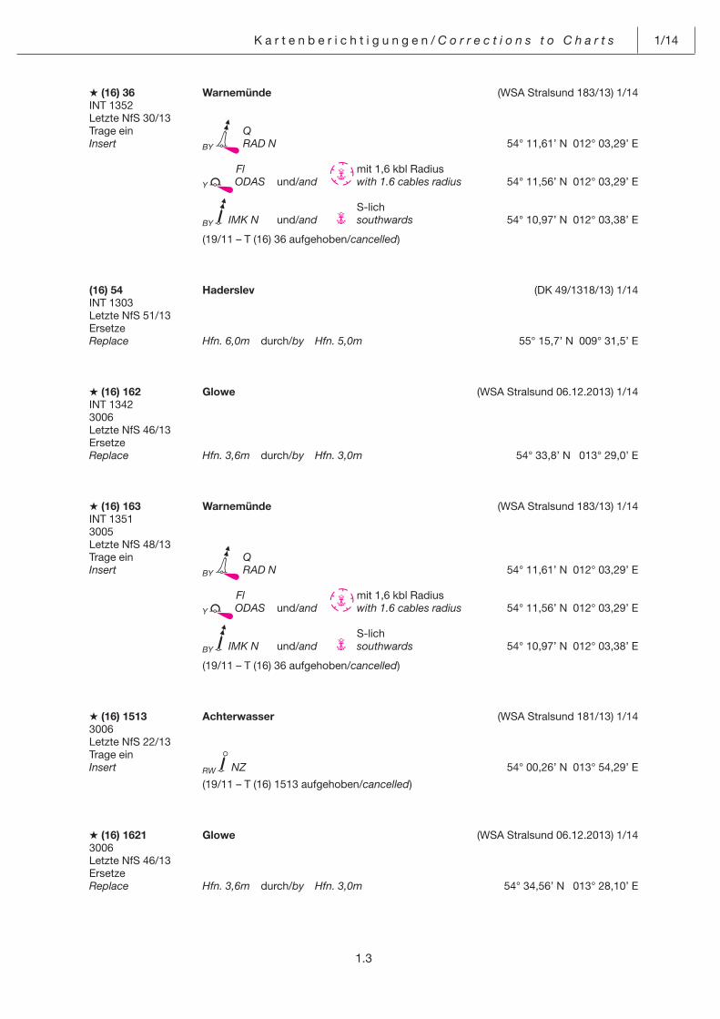
1.3
K a r t e n b e r i c h t i g u n g e n / C o r r e c t i o n s t o C h a r t s 1/14
A (16) 36 Warnemünde (WSA Stralsund 183/13) 1/14INT 1352Letzte NfS 30/13Trage ein QInsert BY RAD N 54° 11,61’ N 012° 03,29’ E
Fl mit 1,6 kbl Radius Y ODAS und/and
with 1.6 cables radius 54° 11,56’ N 012° 03,29’ E
S-lich BY IMK N und/and southwards 54° 10,97’ N 012° 03,38’ E
(19/11 – T (16) 36 aufgehoben/cancelled)
(16) 54 Haderslev (DK 49/1318/13) 1/14INT 1303Letzte NfS 51/13ErsetzeReplace Hfn. 6,0m durch/by Hfn. 5,0m 55° 15,7’ N 009° 31,5’ E
A (16) 162 Glowe (WSA Stralsund 06.12.2013) 1/14INT 13423006Letzte NfS 46/13ErsetzeReplace Hfn. 3,6m durch/by Hfn. 3,0m 54° 33,8’ N 013° 29,0’ E
A (16) 163 Warnemünde (WSA Stralsund 183/13) 1/14INT 13513005Letzte NfS 48/13Trage ein QInsert BY RAD N 54° 11,61’ N 012° 03,29’ E
Fl mit 1,6 kbl Radius Y ODAS und/and
with 1.6 cables radius 54° 11,56’ N 012° 03,29’ E
S-lich BY IMK N und/and southwards 54° 10,97’ N 012° 03,38’ E
(19/11 – T (16) 36 aufgehoben/cancelled)
A (16) 1513 Achterwasser (WSA Stralsund 181/13) 1/143006Letzte NfS 22/13Trage ein Insert RW NZ 54° 00,26’ N 013° 54,29’ E
(19/11 – T (16) 1513 aufgehoben/cancelled)
A (16) 1621 Glowe (WSA Stralsund 06.12.2013) 1/143006Letzte NfS 46/13ErsetzeReplace Hfn. 3,6m durch/by Hfn. 3,0m 54° 34,56’ N 013° 28,10’ E

1/14 K a r t e n b e r i c h t i g u n g e n / C o r r e c t i o n s t o C h a r t s
1.4
A (16) 1671 Warnemünde (WSA Stralsund 183/13) 1/14INT 1354Letzte NfS 51/13Trage ein QInsert BY RAD N 54° 11,61’ N 012° 03,29’ E
Fl mit 1,6 kbl Radius Y ODAS und/and
with 1.6 cables radius 54° 11,58’ N 012° 03,29’ E
BY IMK N 54° 10,97’ N 012° 03,38’ E
zwischen/between 54° 10,64’ N 012° 03,16’ E 54° 10,93’ N 012° 03,11’ E und weiter als Kreisbogen mit 1,6 kbl Radius N-lich um and forward as an arc of a circle with 1.6 cables radius northwards centred 54° 10,94’ N 012° 03,38’ E bis/to 54° 10,96’ N 012° 03,66’ E
zwischen/between 54° 10,96’ N 012° 03,66’ E 54° 10,68’ N 012° 03,71’ E
A (16) 1672 Warnemünde (WSA Stralsund 183/13) 1/14INT 1355Letzte NfS 50/13Trage ein QInsert BY RAD N 54° 11,614’ N 012° 03,286’ E
Fl mit 1,6 kbl Radius Y ODAS und/and
with 1.6 cables radius 54° 11,585’ N 012° 03,290’ E
BY IMK N 54° 10,971’ N 012° 03,377’ E
zwischen/between 54° 10,64’ N 012° 03,16’ E 54° 10,93’ N 012° 03,11’ E und weiter als Kreisbogen mit 1,6 kbl Radius N-lich um and forward as an arc of a circle with 1.6 cables radius northwards centred 54° 10,94’ N 012° 03,38’ E bis/to 54° 10,96’ N 012° 03,66’ E
zwischen/between 54° 10,96’ N 012° 03,66’ E 54° 10,68’ N 012° 03,71’ E
Messgeräte/Gauges in dem Gebiet/in the area
(19/11 – T (16) 1672 aufgehoben/cancelled)
(17) 19 SW-lich Skødshoved. Issehoved Rev (DK 49/1325, 1326/13) 1/14INT 1380Letzte NfS 49/13Trage ein Fl(5)Y.20sInsert Y Mess-G. 56° 10,11’ N 010° 20,13’ E
56° 00,2’ N 010° 34,4’ E
1.5
K a r t e n b e r i c h t i g u n g e n / C o r r e c t i o n s t o C h a r t s 1/14
(17) 22 Hundested (DK 49/1320/13) 1/14Letzte NfS 38/13 Plan D Trage ein Tiefe 45Insert depth 45 55° 57,89’ N 011° 50,54’ E
(5/13 – T (17) 22 aufgehoben/cancelled)
(17) 24 Issehoved (DK 49/1326/13) 1/14INT 1302Letzte NfS 51/13Trage einInsert 56° 00,2’ N 010° 34,4’ E
A (17) 25 (BSH N2) 1/14INT 1301Letzte NfS 49/13 NEUE AUSGABE/NEW EDITION
A (21) 2 W-lich Hohewegrinne (WSA Bremerhaven, Peilplan) 1/14INT 14563011, 3014, 3015Letzte NfS 51/13Trage ein Tiefe 147 und streiche Tiefe 154 dicht dabeiInsert depth 147 and delete depth 154 close by 53° 47,56’ N 008° 08,47’ E
Tiefe 141 und streiche Tiefe 144 dicht dabei depth 141 and delete depth 144 close by 53° 46,77’ N 008° 09,56’ E
Tiefe 136 und streiche Tiefe 141 dicht dabei depth 136 and delete depth 141 close by 53° 46,33’ N 008° 10,04’ E
A (21) 44 (BSH N2) 1/14INT 1452Letzte NfS 47/13 NEUE AUSGABE/NEW EDITION
A T (21) 48 Mühlenberger Loch (WSA Hamburg 68(T)/13) 1/14INT 14553010 Plan A
Letzte NfS 44/13Verlege Oc(2)R.9sRelocate R EZ 4 nach/to 53° 32,739’ N 009° 47,660’ E
R EZ 6 nach/to 53° 32,631’ N 009° 47,692’ E
R EZ 8 nach/to 53° 32,499’ N 009° 47,755’ E
Fl.G.4s G EZ 7 nach/to 53° 32,500’ N 009° 47,717’ E
A (21) 106 Süderoogsand (WSA Tönning 187/13) 1/143013Letzte NfS 51/13Trage einInsert 54° 25,26’ N 008° 28,49’ E
1/14 K a r t e n b e r i c h t i g u n g e n / C o r r e c t i o n s t o C h a r t s
1.6
(22) 244 IJmuiden-Ansteuerung (NL 50/528/13) 1/14INT 1418Letzte NfS 50/13Streiche Traffic Centre IJmuidenDelete Ch 7 52° 35,9’ N 004° 05,8’ E 52° 32,9’ N 004° 30,9’ E 52° 31,2’ N 003° 56,3’ E 52° 29,7’ N 004° 24,6’ E 52° 24,8’ N 004° 25,9’ E
IJmuiden Port Control Ch 61 52° 32,8’ N 004° 30,1’ E 52° 24,5’ N 004° 26,5’ E 52° 27,8’ N 004° 24,1’ E
Ersetze Traffic Centre IJmuiden PortReplace IJmuiden durch/by Control Ch 7 Ch 61 52° 39,74’ N 004° 28,69’ E 52° 19,44’ N 004° 18,49’ E
Traffic Centre IJmuiden IJmuiden durch/by Approach Ch 7 Ch 7 52° 35,56’ N 004° 04,55’ E 52° 26,62’ N 003° 54,82’ E
Traffic Centre IJmuiden IJmuiden durch/by Approach Ch 7 Ch 7 52° 29,23’ N 003° 43,56’ E
Anmerkung: Richtung der Pfeile unverändert Remark: Arrows pointing unchanged
Radar Range TRAFFIC CENTRE IJMUIDEN (VHF 7) durch/by Radar Range IJMUIDEN PORT CONTROL (VHF 61) 52° 38,20’ N 004° 21,80’ E
Trage ein IJmuiden Port Control Pfeil in Richtung 280°Insert Ch 61 arrow pointing 280° 52° 30,93’ N 004° 13,24’ E
IJmuiden Port Control Pfeil in Richtung 100° Ch 61 arrow pointing 100° 52° 28,96’ N 004° 12,71’ E
(22) 246 IJmuiden-Ansteuerung (NL 50/528/13) 1/14INT 1416Letzte NfS 49/13Ersetze Traffic Centre IJmuiden PortReplace IJmuiden durch/by Control Ch 7 Ch 61 52° 19,44’ N 004° 18,49’ E
Anmerkung: Richtung des Pfeils unverändert Remark: Arrow pointing unchanged
K a r t e n b e r i c h t i g u n g e n / C o r r e c t i o n s t o C h a r t s 1/14
1.7
Teil 1 A – Britische Karten/Part 1 A – British Admiralty Charts
Dieser Abschnitt enthält Abdrucke für Kartenberichtigungen nach den Admiralty Notices to Mariners, die vom UK Hydro-graphic Office (UKHO) herausgegeben wurden. Ergänzende Hinweise und die vollständige Liste der Seegebiete und der ihnen zugeordneten Seekarten siehe Beilage in NfS-Ausgabe 1/2014.This part contains reprints of corrections to charts published in the Admiralty Notices to Mariners issued by the UK Hydro-graphic Office (UKHO). More information and the complete list of sea areas and charts related to them is provided in Enclosure NfS issue 1/2014.
Seegebiet/Sea area ⇓
(11)
(11)
5398 RUSSIA - Baltic Sea Coast - Kaliningradskiy Morskoy Kanal - Povorot Izhevskiy Eastwards - Lights. Lights in line. Submarine cable.
Light List Vol. C, 2013/14, 3105.5, 3105.51, 3105.59, 3105.591, 3105.6, 3105.61Source: Russian Notices 44/6718/13, 45/6881/13 and 48/7400/13
Chart 2278 (panel B, Kaliningradskiy Morskoy Kanal) [ previous update 3610/13 ] PULKOVO 1942 DATUM
Insert the accompanying block, showing new lights and amendments to lights in line and submarine cable, centred on: 54° 41´·29N., 20° 11´·30E.
Chart 2278 (panel C, Continuation of Kaliningradskiy Morskoy Kanal) [ previous update 3610/13 ] PULKOVO 1942 DATUM
Insert the accompanying block, showing new lights and amendments to lights in line and submarine cable, centred on: 54° 41´·27N., 20° 11´·40E.
(12)
(12)
5450 SWEDEN - East Coast - Ålandskobb S and Siarö NW - Buoyage.Source: Swedish Notice 471/9118/13
Chart 887 (INT 1775) [ previous update 4493/13 ] WGS84 DATUM
Replace with Q.G59° 41´·22N., 18° 59´·44E.
with Fl.R.3s59° 33´·80N., 18° 38´·31E.
Chart 888 (INT 1776) [ previous update 4784/13 ] WGS84 DATUM
Replace with Q.G59° 41´·22N., 18° 59´·44E.
(12)
5401(T)/13 SWEDEN - East Coast - Stockholm - Saltsjön - Danvikskanalen - Signal station. Lights.Bridge.
Source: Swedish Notice 471/9136(T)/131. The signal station lights at the entrance to Danvikskanalen (59° 18´·92N., 18° 06´·41E.) are temporarily extinguished and
Danviksbron bridge (59° 18´·82N., 18° 06´·28E.) is temporarily unmanned.2. Vessels should monitor VHF Channels 12 and 16 for the latest information.
(All positions are referred to WGS84 Datum)
Charts affected - 811 (INT 1239) - 820 (INT 1238)
(22)
5433(P)/13 NETHERLANDS - Approaches to IJmuiden - Vessel traffic service.
Source: Netherlands Notice 48/517(P)/131. There are changes to the IJmuiden Vessel Traffic Service (VTS) procedures which will be implemented at 0000 UTC on
15 December 2013.2. Charts will be updated by Notice to Mariners when full details are known.
Charts affected - 125 (INT 1469) - 1631 (INT 1418)
H a n d b u c h b e r i c h t i g u n g e n / C o r r e c t i o n s t o S a i l i n g D i r e c t i o n s 1/14
2.1
Handbuchberichtigungen/Corrections to Sailing Directions
Teil 2 – Deutsche Seehandbücher/Part 2 – German Sailing Directions
(Gültig bis zur nächsten Ausgabe)(Valid till next edition)
2009 Dänemark u. W-Küste Schweden 2013
S. 297. Engstellen (Fortsetzung). Kl a p p b r ü c k e D a l b o b r o n, ersetze alle Angaben durch:
K l a p p b r ü c k e D a l b o b r o nAbmessungen der Durchfahrt
Höhe 16,5 m Breite 29,5 m im geschlossenen Zustand
(SE 473/7029/13) 1/14
5001 Hb. Revierfunkdienst 2013
S. 137. IJmuiden-North Sea Canal-Amsterdam. V e r k e h r s s i c h e r u n g u n d - ü b e r w a c h u n g,Schiffsverkehrsdienst, VTS Haven Amsterdam (Ansteuerung), Kontakt, ersetze alle Angaben und die Berichtigung 50/13 durch:
Kontakt Ruf siehe FrequenzFrequenz UKW-Kanal 07 (Erstkontakt; Ruf IJmuiden Approach)
61 (Ruf IJmuiden Port Control)Telefon +31 (0) 2 55 52 39 34
20 5 23 47 78 56 45 00 (Lotsenanforderung) 6 23 91 30, 5 23 47 62 (Gefahrgutmeldung)
Telefax +31 (0) 2 55 53 25 35 (Lotsenanforderung) 20 5 23 48 00 6 26 62 15 (Gefahrgutmeldung)
E-Mail [email protected] [email protected] (Lotsenanforderung) [email protected] (Gefahrgutmeldung)
(NL 50/527/13) 1/14
S. 138. IJmuiden-North Sea Canal-Amsterdam. L o t s e n, Kontakt, ersetze alle Angaben und die Berichtigung 50/13 durch:
Kontakt Ruf siehe FrequenzFrequenz UKW-Kanal 07 (ETA IJmuiden-Amsterdam und Den Helder; Ruf IJmuiden
Approach) 04 (ETD nur IJmuiden-Amsterdam; Ruf Amsterdam Port Control)Telefon +31 (0) 2 55 56 45 00 (Anforderung) 56 45 03 (Versetzdienst) Telefax +31 (0) 2 55 53 25 35 (Anforderung)E-Mail [email protected]
(NL 50/527/13) 1/14
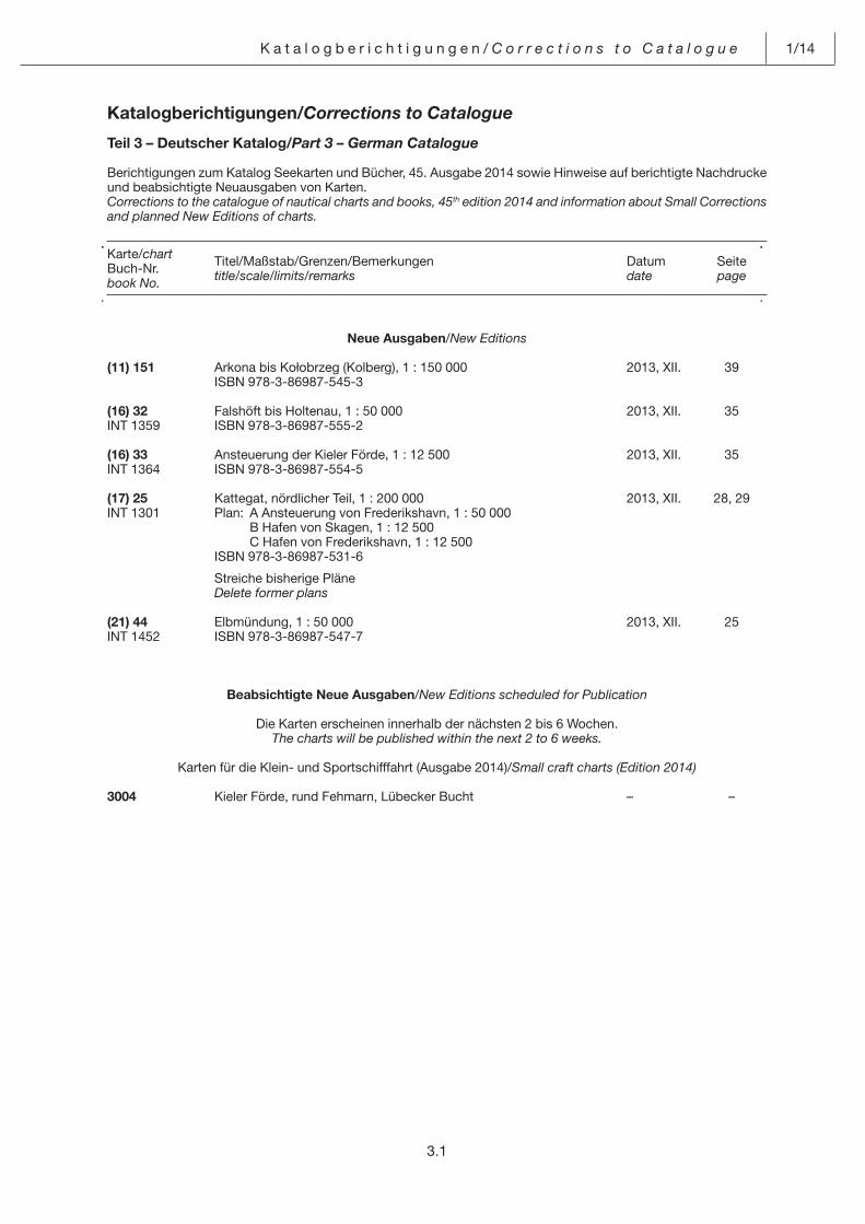
Katalogberichtigungen/Corrections to Catalogue
Teil 3 – Deutscher Katalog/Part 3 – German Catalogue
Berichtigungen zum Katalog Seekarten und Bücher, 45. Ausgabe 2014 sowie Hinweise auf berichtigte Nachdrucke und beabsichtigte Neuausgaben von Karten.Corrections to the catalogue of nautical charts and books, 45th edition 2014 and information about Small Corrections and planned New Editions of charts.
Karte/chartBuch-Nr.book No.
Titel/Maßstab/Grenzen/Bemerkungentitle/scale/limits/remarks
Datumdate
Seitepage
3.1
K a t a l o g b e r i c h t i g u n g e n / C o r r e c t i o n s t o C a t a l o g u e 1/14
Neue Ausgaben/New Editions
(11) 151 Arkona bis Kołobrzeg (Kolberg), 1 : 150 000 2013, XII. 39 ISBN 978-3-86987-545-3
(16) 32 Falshöft bis Holtenau, 1 : 50 000 2013, XII. 35INT 1359 ISBN 978-3-86987-555-2
(16) 33 Ansteuerung der Kieler Förde, 1 : 12 500 2013, XII. 35INT 1364 ISBN 978-3-86987-554-5
(17) 25 Kattegat, nördlicher Teil, 1 : 200 000 2013, XII. 28, 29INT 1301 Plan: A Ansteuerung von Frederikshavn, 1 : 50 000 B Hafen von Skagen, 1 : 12 500 C Hafen von Frederikshavn, 1 : 12 500 ISBN 978-3-86987-531-6
Streiche bisherige Pläne Delete former plans
(21) 44 Elbmündung, 1 : 50 000 2013, XII. 25INT 1452 ISBN 978-3-86987-547-7
Beabsichtigte Neue Ausgaben/New Editions scheduled for Publication
Die Karten erscheinen innerhalb der nächsten 2 bis 6 Wochen.The charts will be published within the next 2 to 6 weeks.
Karten für die Klein- und Sportschifffahrt (Ausgabe 2014)/Small craft charts (Edition 2014)
3004 Kieler Förde, rund Fehmarn, Lübecker Bucht – –
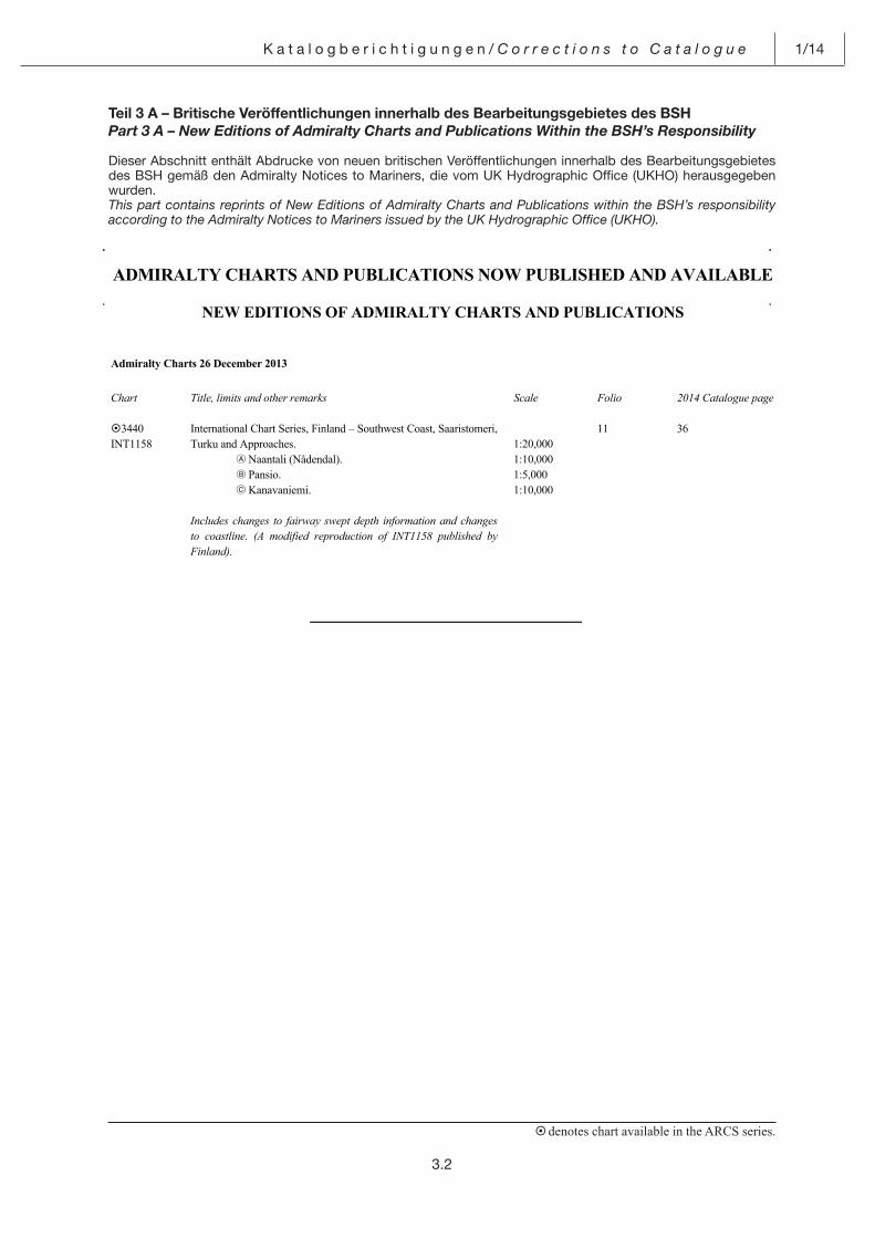
Teil 3 A – Britische Veröffentlichungen innerhalb des Bearbeitungsgebietes des BSH
Part 3 A – New Editions of Admiralty Charts and Publications Within the BSH’s Responsibility
Dieser Abschnitt enthält Abdrucke von neuen britischen Veröffentlichungen innerhalb des Bearbeitungsgebietes des BSH gemäß den Admiralty Notices to Mariners, die vom UK Hydrographic Office (UKHO) herausgegeben wurden.This part contains reprints of New Editions of Admiralty Charts and Publications within the BSH’s responsibility according to the Admiralty Notices to Mariners issued by the UK Hydrographic Office (UKHO).
K a t a l o g b e r i c h t i g u n g e n / C o r r e c t i o n s t o C a t a l o g u e 1/14
denotes chart available in the ARCS series.
ADMIRALTY CHARTS AND PUBLICATIONS NOW PUBLISHED AND AVAILABLE
NEW EDITIONS OF ADMIRALTY CHARTS AND PUBLICATIONS
Admiralty Charts 26 December 2013
Chart Title, limits and other remarks Scale Folio 2014 Catalogue page
3440 INT1158
International Chart Series, Finland – Southwest Coast, Saaristomeri, Turku and Approaches.
A Naantali (Nådendal). B Pansio. C Kanavaniemi.
Includes changes to fairway swept depth information and changes to coastline. (A modified reproduction of INT1158 published by Finland).
1:20,000 1:10,000 1:5,000 1:10,000
11 36
3.2
4.1
M i t t e i l u n g e n / N o t i f i c a t i o n s 1/14
Inhalt – Teil 4 Mitteilungen Contents – Part 4 Notifications
Naval Cooperation and Guidance for Shipping (NCAGS)
4.3 Naval Cooperation and Guidance for Shipping (NCAGS)
Führen von Lichtern und Signalkörpern für manöv-rierunfähige Fahrzeuge nach den Kollisionsverhü-tungsregeln (KVR)
4.6 Use of “Not Under Command” (NUC) signals of the International Regulations for Preventing Collisions at Sea (COLREGS)
Sondervorschriften für Fahrzeuge der Bundeswehr über das Führen von Lichtern und Signalkörpern
4.7 Special Regulations for the Display of Lights and Shapes on Vessels of the Federal German Armed Forces
Verwendung von Leuchtkörpern durch Flugzeuge der deutschen Marine
4.9 Lights used by aircraft of the Federal German Navy
Vorbeugende schiffsbezogene Maßnahmen zum Schutz meerestechnischer Anlagen und Bauwerke (Offshore-Anlagen, Windparks)
4.9 Preventive shipboard measures for the protection of offshore installations and structures, wind farms
Deutschland. Windparks. Eingerichtete Sicherheits-zonen nach § 11 der Verordnung über Anlagen see-wärts der Begrenzung des deutschen Küstenmeeres (Seeanlagenverordnung-SeeAnlV) und Regelungen zum Befahren einer Sicherheitszone nach § 7 Abs. 3 der Verordnung zu den Internationalen Regeln zur Verhütung von Zusammenstößen auf See (VO-KVR)
4.10 Germany. Wind farms. Safety zones established under Art. 11, Seeanlagenverordnung (SeeAnlV – Marine Facilities Ordinance) and regulations con-cerning navigation in a safety zone under Art. 7, para. 3, of the Ordinance on the International Regu-lations for Preventing Collisions at Sea (VO-KVR)
Aufnahme und Auswertung von Wetterberichten; Wetterroutenberatung
4.11 Reception and evaluation of weather reports; weather routeing
Richtlinien für die Überwachung von Schiffsstabili-tät und Anwendung der Stabilitätsunterlagen im Bordgebrauch
4.12 Guidelines for the Onboard Management of Stability and using the stability information on board
Verkehr von Hochgeschwindigkeitsfahrzeugen 4.13 Operation of high speed craft
Transport von Kernbrennstoffen und Großquellen durch die Hoheitsgewässer der Bundesrepublik Deutschland
4.13 Transport of fissile materials and large sources through the Territorial Waters of the Federal Repub-lic of Germany
Ausstellung von Flaggenzertifikaten 4.14 Issuance of Flag Certificates
Verpflichtung zur Auskunftserteilung 4.14 Obligation to provide information
Wachdienst auf Seeschiffen. Besetzung des Aus-gucks. Benutzung des Wachalarms
4.15 Watchkeeping on seagoing vessels. Manning of the lookout. Use of the bridge navigational watch alarm system
Gefahren bei Manöverabsprachen über UKW 4.15 Dangers in the use of VHF radio in collision avoid-ance
Fehlalarme im Weltweiten Seenot- und Sicherheits-funksystem (GMDSS)
4.16 False distress alarms in the Global Maritime Distress and Safety System (GMDSS)
Funktagebuch. Funkstellen an Bord von Seefahr-zeugen, die aufgrund des SOLAS-Übereinkommens mit GMDSS-Funkanlagen ausgerüstet sind. Übrige Sprech-Seefunkstellen, die zur Führung eines See-tagebuchs verpflichtet sind
4.16 Radio logbook. Radio stations on board marine ves-sels fitted with GMDSS radiocommunication equip-ment in accordance with the SOLAS Convention. Other marine radiotelephone stations required to keep a marine logbook
Mitführen des Bands III des Internationalen Hand-buchs für die luftgestützte und maritime Suche und Rettung (IAMSAR-MANUAL) an Bord von Schiffen
4.16 Carriage of Volume III of the International Aeronauti-cal and Maritime Search and Rescue Manual (IAM-SAR Manual) on board ships
IMO-Standardredewendungen für die Seefahrt (IMO Standard Marine Communication Phrases [SMCP])
4.17 IMO Standard Marine Communication Phrases (SMCP)
Hinweise für den Seelotsenversetzdienst mit Hub-schraubern
4.17 Recommendations for the Helicopter Transfer of Marine Pilots
1/14 M i t t e i l u n g e n / N o t i f i c a t i o n s
4.2
Deutschland. Ausrüstung mit nautischen Unter-lagen nach der Schiffssicherheitsverordnung
4.17 Germany. Carriage of nautical publications accord-ing to the Schiffssicherheitsverordnung (Ordinance for the Safety of Seagoing Ships)
Deutschland. Anwendung der Kollisionsverhü-tungsregeln (KVR), der Anlaufbedingungsverord-nung (AnlBV) und der Seeschifffahrtsstraßen-Ord-nung (SeeSchStrO)
4.18 Germany. Application of the International Regula-tions for Preventing Collisions at Sea, the Internal Waters (Entring Requirements) Ordinance, and the Traffic Regulations for Navigable Maritime Waterways (Seeschifffahrtsstraßenordnung – ”SeeSchStrO“)
Particularly Sensitive Sea Area (PSSA) 4.23 Particularly Sensitive Sea Area (PSSA)
Automatisches Schiffsidentifizierungssystem (AIS) 4.24 Automatic Identification System (AIS)
Ausrüstungspflicht mit Schiffsdatenschreibern(VDR)
4.26 Mandatory carriage of Voyage Data Recorders(VDR)
Verwendung von ECDIS-Systemen an Bord von Seeschiffen. Hinweise zu Anomalien in der Anzeige
4.29 Carriage of ECDIS systems on board sea-going vessels. Note to display anomalies
ECDIS-Datendienst 4.31 ECDIS Data Service
GNSS – Global Navigation Satellite Systems 4.32 GNSS – Global Navigation Satellite Systems
Zusammenhang zwischen dem geodätischen Bezug von Seekarten und der Positionsgenauigkeit von Satelliten-Navigationssystemen (GNSS)
4.32 Relationship between the geodetic reference of charts and the positional accuracy of Global Navi-gation Satellite Systems (GNSS)
Deutschland. Umstellung des Seekartennulls mit Bezug auf den niedrigstmöglichen Gezeitenwas-serstand (SKN-LAT) in den amtlichen Seekarten der Bundesrepublik Deutschland abgeschlossen
4.34 Germany. Change to Lowest Astronomical Tide (LAT) as Chart Datum for the official nautical charts of the Federal Republic of Germany completed
Bekanntmachung über die von der IMO beschlos-senen verbindlichen Schiffsmeldesysteme
4.35 Notification of mandatory ship reporting systems adopted by IMO
Bekanntmachung über die von der IMO beschlos-senen verbindlichen Schiffswegeführungssysteme außerhalb der Küstenmeere
4.36 Notification of mandatory ships’ routeing systems adopted by IMO outside the territorial seas
Bekanntmachung über die von der IMO angenom-menen Verkehrstrennungsgebiete
4.36 Notification of traffic separation schemes adopted by IMO
Ostsee. Empfehlung der Kommission der Lotsen-verwaltungen
4.40 Baltic Sea. Recommendation of the Baltic Pilotage Authorities Commission
Ostsee. Sichere Navigation in der Kadetrinne (Kadetrenden). Warnung
4.41 Baltic Sea. Safe navigation in the Kadetrenden (Kadetrinne). Warning
Panama. Beachtung der Regeln für das Befahren des Panamakanals
4.43 Panama. Compliance with the rules for transiting the Panama Canal
Kanada. Teilnahme an Northern Canada Vessel Traffic Services (NORDREG) in den kanadischen Gewässern N-lich 60° N
4.43 Canada. Participation in the Northern Canada Ves-sel Traffic Services (NORDREG) in Canadian waters north of 60° N
Piraterie und bewaffnete Überfälle auf Schiffe 4.43 Piracy and armed robbery against ship
IMB Piracy Reporting Centre 4.45 IMB Piracy Reporting Centre
MARPOL 73/78 – Internationales Übereinkommen von 1973 zur Verhütung der Meeresverschmutzung durch Schiffe und das Protokoll von 1978 zu diesem Übereinkommen
4.46 MARPOL 73/78 – International Convention for the Prevention of Pollution from Ships, 1973, as modified by the Protocol of 1978 relating thereto
Deutschland. Kieler Bucht. Hohwachter Bucht.Todendorf. Putlos. Schießzeiten
4.46 Germany. Kieler Bucht. Hohwachter Bucht. Todendorf. Putlos. Firing exercises
Deutschland. Ostsee. Zeitweilige Messgeräte 4.47 Germany. Baltic Sea. Temporary measuring instru-ments
Nautischer Informationsdienst. Seebücher 4.48 Navigational Information Service. Nautical Books
M i t t e i l u n g e n / N o t i f i c a t i o n s 1/14
4.3
Pos: 1 /NfS/Mitteilungen/jährliches Heft 1/01_NCAGS @ 0\mod_1385035369795_6.docx @ 3918 @ @ 1
Naval Cooperation and Guidance for Shipping (NCAGS)
Naval Cooperation and Guidance for Shipping (NCAGS)
(Siehe NfS-Heft 1/2013) (See NfS issue 1/2013) Vorbemerkung Preliminary remark Der Handel über See ist für viele Staaten von grund-legender Bedeutung, denn der wirtschaftliche Wohl-stand hängt ganz entscheidend von der Fähigkeit ab, Handel zu treiben. Eine wesentliche Vorausset-zung hierfür ist wiederum die Freiheit der Schifffahrt. Die Fähigkeit der NATO mit der Handelsschifffahrt zusammenzuarbeiten, wird als „Naval Cooperation and Guidance for Shipping (NCAGS)“ bezeichnet. NCAGS umfasst Taktiken und Verfahren, die immer dort Anwendung finden, wo die Einsätze von See-streitkräften Auswirkungen auf die Handelsschifffahrt haben können oder wo die Handelsschifffahrt Teil des militärischen Auftrags ist. NCAGS bildet die Schnittstelle zwischen beiden Interessenträgern.
Maritime trade is of fundamental interest to nations; Economic wealth depends on the ability to trade, which in turn depends upon freedom of navigation. NATO’s capability for operations involving merchant shipping is Naval Cooperation and Guidance for Shipping (NCAGS), with its associated tactics, tech-niques and procedures. Maritime operations fre-quently affect merchant shipping. Similarly merchant shipping may impact maritime operations or be in-volved in support of the Maritime Commander’s mis-sion. NCAGS is the interface between both stakeholders.
Einführung NCAGS bietet der Handelsschifffahrt Zusammen-arbeit, Beratung und Anleitung. Sie unterstützt den Maritimen Befehlshaber (Maritime Commander) bei der Erfüllung seines Auftrags mit dem Ziel, die Sicherheit und den Schutz für Handelsschiffe zu steigern.
Introduction NCAGS is the provision of cooperation, guidance, advice and assistance to merchant shipping in sup-port of the Maritime Commander’s mission and to enhance the safety and security of merchant ships.
Effekte NCAGS trägt zu folgenden Effekten bei:
Effects NCAGS enhances and contributes primarily to the following effects:
1. Bewegungsfreiheit der Seestreitkräfte 1. Maritime Commander’s freedom of manoeuvre2. Militärische Entscheidungsfindung 2. Maritime Commander’s decision-making process3. Effektiver und effizienter Einsatz militärischer
Mittel 3. Effective and efficient commitment and use of
military assets 4. Wirtschaftlicher Wohlstand der Staaten sowie
internationale Stabilität 4. Nations’ economic well-being and international
stability 5. Freier Seehandel im Einsatzgebiet 5. Free flow of maritime trade in the area of opera-
tions 6. Vertrauen der Handelsschifffahrt in militärische
Einsätze 6. Merchant shipping’s confidence in military opera-
tions Rahmenbedingungen NCAGS findet bei NATO-Einsätzen in Zeiten von Spannungen, Krisen bis hin zum Krieg und bei Ein-sätzen unter UN-Mandat Anwendung. Die Teilnahme der Handelsschifffahrt an NCAGS-Einsätzen erfolgt normalerweise auf freiwilliger Basis. Unter besonde-ren Umständen kann der Befehlshaber der Schiff-fahrt Anweisungen erteilen, um z. B. zum Schutz lebenswichtiger Güter Konvois zu formieren.
FrameworkNCAGS applies to NATO operations in times of ten-sion, crisis, up to war and to operations conducted under UN mandate. The concept outlines the coop-eration with all civil actors involved in merchant shipping operations. The participation of merchant shipping in NCAGS operations is usually on a volun-tary basis. In times of high tension the Maritime Commander might order shipping to form up con-voys to ensure protection of vital goods.
Auslösung Einsätze von Seestreitkräften mit Einbindung der Handelsschifffahrt erfordern NCAGS.
ExecutionMaritime operations which involve merchant ship-ping should include NCAGS.
Die Grenzen des Einsatzgebiets der Seestreitkräfte werden vom nautischen Warndienst „Worldwide Navigational Warning Service“ (WWNWS) der IHO bekanntgegeben.
The area of operations will be declared by IHO –Worldwide Navigational Warning Service (WWNWS).
Die multinational besetzte NCAGS-Organisation ver-schafft dem Befehlshaber einen Überblick über alle den Seehandel betreffenden Belange innerhalb eines Einsatzgebiets. Darüber hinaus bietet NCAGS allen Handelsschiffen Anleitung und Beratung und stellt den Informationsaustausch sicher. Die Teilnahme an diesem Informationsaustausch wird allen Schiffen, die das Einsatzgebiet durchfahren, dringend emp-
The multinational manned NCAGS organization pro-vides the Maritime Commander with situational awareness of all maritime trade related issues inside an area of operations. Furthermore NCAGS provides guidance and advice for all merchant vessels and ensures exchange of information. A participation in this information exchange is strongly recommend-ed for all ships transiting the area of operations.
1/14 M i t t e i l u n g e n / N o t i f i c a t i o n s
4.4
fohlen. In Abhängigkeit von der militärischen Situa-tion kann der Befehlshaber den am Informationsaus-tausch teilnehmenden Schiffen Schutz anbieten. Staaten können für ausgewählte Schiffe über ihre nationalen Schifffahrtsbehörden Schutz anfordern.
Based on the military situation, the Maritime Com-mander may offer close or distant protection for those ships participating in the information exchange. Nations may request protection for selected vessels through their National Shipping Agencies.
Handelsschiffe oder -unternehmen zeigen ihre Teil-nahme am Informationsaustausch mit NCAGS an, indem sie eine Format-ALFA-Nachricht senden bzw. auf Anforderung eine Ship Data Card (Formate siehe unten). Diese Nachricht sollte unter Verwendung des Kommunikationsmittels gesendet werden, das in der entsprechenden WWNWS-Meldung ange-geben ist.
Merchant ships or companies will indicate their participation to the NCAGS information exchange process by transmitting a Format ALFA message or on request a Ship Data Card (see formats below). The message should be send via the means of communications given by respective WWNWS mes-sage.
NCAGS-Struktur Ein NCAGS-Stabsoffizier ist integraler Bestandteil der maritimen Einsatzführung. Er berät den Befehls-haber, wie dieser den Einsatz der Seestreitkräfte und die Handelsschifffahrt im Einsatzgebiet in Einklang bringen kann. Er plant z. B. Meldeverfahren oder mi-litärische Maßnahmen zur Steuerung von Handels-schiffsbewegungen. Innerhalb des Einsatzgebiets stationierte Deployed NCAGS Elements (DNE) unter-stützen den NCAGS-Stabsoffizier. Die DNEs sam-meln vor Ort Informationen über die Eigenheiten des Seehandels und der Schifffahrt und verschaffen dem Befehlshaber einen besseren Überblick über die Lage im Einsatzgebiet. Die DNEs stellen zudem Kapitänen und Unternehmen in Live-Briefings oder per E-Mail Routeninformationen zur Verfügung und fungieren innerhalb ihres Zuständigkeitsbereichs als Kontaktstelle für Handelsschiffe.
NCAGS StructureA Staff Officer NCAGS will be an integral part of the Maritime Command. He will advise the Maritime Commander to deconflict between the maritime operation and merchant shipping. He initiates report-ing schemes and/or measures for managing mer-chant ships movements. Deployed NCAGS Elements (DNE), which will be located inside the area of operations, support the Staff Officer NCAGS. The DNEs will collect pattern of life information on maritime trade and shipping and contribute to the Commander’s situational awareness. The DNEs will provide sailing information for masters and compa-nies in live briefings or via e-mail and will act as the contact point for merchant ships inside their area of responsibility.
NCAGS in militärischen Übungen Eine NCAGS-Organisation ist ein integraler Bestand-teil der meisten Seemanöver. Die NATO und ihre Staaten müssen ihre Fähigkeit zur Zusammenarbeit mit der Handelsschifffahrt regelmäßig üben. Die NCAGS-Organisation greift auf Reservisten zurück, die aus allen Bereichen der Handelsschifffahrt sowie aus dem ehemaligen aktiven Marinedienst rekrutiert werden. Um realitätsnah üben zu können, ist die ak-tive Teilnahme von Schiffen und Unternehmen, die innerhalb des Manövergebiets Handel treiben, sehr willkommen. Teilnehmende Schiffe werden in das Manöver integriert, ohne dass es hierbei zu zeitli-chen Verzögerungen kommt. Die Schiffe werden auf ihrer Passage durch das Übungsgebiet von NCAGS über die militärische Lage informiert und beraten. Die Schiffsbewegungen werden von den Seestreit-kräften überwacht. Handelsschiffe und Unterneh-men, die bereit sind, ihre eigenen Übungserforder-nisse zeitlich abzustimmen, sind ebenfalls sehr willkommen. Boarding-Übungen, seemännische Übungen oder allgemeine Sicherheitsübungen sind denkbar. Informationen zu anstehenden Seemanö-vern, bei denen NCAGS zur Anwendung kommt, werden über die Nachrichten für Seefahrer rechtzei-tig bekannt gegeben.
NCAGS in Military Exercises An NCAGS organization is an integral part of most naval exercises. NATO and nations have to ensure their capability of cooperation with merchant ship-ping. NCAGS employs Naval Reserve personnel, re-cruited from all branches of merchant shipping, as well as from former regular service. To ensure realis-tic training, a participation of ships and companies trading inside the exercise areas is highly appre-ciated. Usually on a non-delaying basis, participating ships become part of the exercise. While on passage the ships will be informed and advised about military situation. Their movements will be tracked by military assets. Merchant ships and companies willing to synchronize their own training requirements are wel-comed as well. Boarding exercises, seamanship or general safety drills may result. Information about upcoming naval exercises including NCAGS will be distributed via Notice to Mariners well in advance.
NCAGS-Kontaktstelle Das Dezernat Marineschifffahrtleitung des deut-schen Marinekommandos fungiert als militärische Kontaktstelle für alle die Handelsschifffahrt betref-fenden Angelegenheiten. Bitte wenden Sie sich an:
NCAGS Point of ContactThe NCAGS Department of the German Navy Com-mand acts as the military contact point for all mer-chant shipping related issues. Please contact:
M i t t e i l u n g e n / N o t i f i c a t i o n s 1/14
4.5
Marinekommando/DEU Navy HQ Dezernat Marineschifffahrtleitung/NCAGS AWNIS Department Reichspräsident-Ebert-Kaserne Osdorfer Landstr. 365 22589 Hamburg Germany Tel.: +49 40 86648 4581 Fax: +49 40 86648 4575 [email protected] [email protected] www.marine.de Mehr Informationen zum Thema Schifffahrt finden Sie auf der Website des NATO Shipping Centre am MARCOM Northwood:
More information for shipping is provided by the NATO Shipping Centre at MARCOM Northwood:
http://www.shipping.nato.int [email protected]
http://www.shipping.nato.int [email protected]
FORMAT ALFA
The Format ALFA is the principal means for initiating the information exchange process between NCAGS and merchant ships
(1) Vessel’s name (2) International Radio Call Sign (IRCS) (3) Flag (4) IMO number (5) MMSI (6) Inmarsat telephone number (7) Telex and fax number (8) E-Mail address (9) Current position (at time UTC), course and planned passage speed (10) Waypoints of track through Area of Operations (11) Next port of call and ETA (UTC) (12) Last port of call (13) Name and address of ship owner and Operator/Charterer (14) Helicopter transfer site (if applicable) (15) Crew numbers and nationalities (16) Hazardous cargo (category) details (if applicable) SHIP DATA CARD If more information is required, NCAGS may request a Ship Data Card (SDC) of selected vessels.
A SDC may be requested at least 24 hours prior to entering the area of operations.
The format is divided into four sections:a. Section A covers basic details of the vessel b. Section B covers details of the current voyage c. Section C covers details of the ships operator d. Section D covers cargo data.
Section A – Ship Data
(1) Ship’s name (2) International call sign (3) Type of vessel (4) Flag of registry (5) IMO number (6) Port of registry (7) Overall length (8) Vessel’s width (9) Maximum draft for present voyage (metres) (10) Vessel’s gross tonnage (GT)
1/14 M i t t e i l u n g e n / N o t i f i c a t i o n s
4.6
(11) Speed (a) Service speed (b) Maximum speed (c) Minimum speed
(12) Significant appearance of vessel for optical recognition (e. g. shape, hull/superstructure, colour, cargo gear, manifolds)
(13) MMSI (Maritime Mobile Services Identity) number (14) Name of communication station being copied (15) INMARSAT telephone numbers (16) INMARSAT Fax numbers (17) INMARSAT telex numbers (18) INMARSAT Data numbers (19) Other communication means including e-mail addresses Section B – Voyage Data
(20) Intended movement – description of passage (21) Last port/country of call including actual date and time of departure from last port (22) Next port of call including ETA at next port of call (23) Current Position (24) Date/time and position entering the Area of Operations
(a–x) waypoints of intended track through Area of Operations (date/time – latitudes/longitudes) (25) Position and date/time of departing the Area of Operations Section C – Operator Data
(26) Name of ship owner/operator including address of ship owner, name of charterer (if any) and address of operator/charterer
(27) E-Mail address of the above (28) Telephone number of above (29) Fax number of above Section D – Cargo Data
(30) Quantity and nature of main/relevant cargo (31) Shippers of main/relevant cargo (name and address) (32) Origin of main/relevant cargo (33) Consignee of main/relevant cargo (34) Final destination of main/relevant cargo (35) Special queries appropriate to current operations such as “State if any cargo/person is carried
being subject to UN Sanctions, by YES or NO” (if the answer to the query is YES, then describe on a separate sheet).
Remarks
If ship’s masters cannot submit all answers to the required items, they may state so and indicate NOT KNOWN if that is the reason. However, they should try to send the Format as complete as possible and liaise with the owners/operators/charterers as soon as possible to get the required information. Owners/operators/managers may contact the NCAGS organization directly to speed up the process of participation. All information is for military purpose only and will not be promulgated outside military authorities.
A completed Format ALFA or Ship Data Card should have the respective heading. Any substantial change to a previously submitted Format ALFA/SDC should be updated by sending another Format ALFA/SDC.
(BMVI Z34) 1/14 Pos: 2 /NfS/Mitteilungen/jährliches Heft 1/02_Führen von Lichtern und Signalkörpern nach den KVR @ 0\mod_1382095984405_6.docx @ 3628 @ @ 1
Führen von Lichtern und Signalkörpern für manövrierunfähige Fahrzeuge nach den Kolli-sionsverhütungsregeln (KVR).
Use of “Not Under Command” (NUC) signals of the International Regulations for Preventing Collisions at Sea (COLREGs).
(1/2013-Wiederholung) (1/2013-repetition)1 Der Schiffssicherheitsausschuss der Internatio-
nalen Seeschifffahrts-Organisation (IMO) hat eine zunehmende Verwendung von Lichtern und Signalkörpern für manövrierunfähige Fahrzeuge unter Umständen festgestellt, die vernünftiger-weise nicht als „außergewöhnlich“ im Sinne der Regel 3 f) KVR zu bezeichnen sind.
1 At its forty-first session (18 to 22 September 1995), the Sub-Committee on Safety of Naviga-tion expressed concern about an increase in the use of NUC lights in circumstances which cannot reasonably be classed as “exceptional”, as defined in rule 3 f) of the International Regu-lations for Preventing Collisions at Sea (COLREGs), 1972, as amended.
M i t t e i l u n g e n / N o t i f i c a t i o n s 1/14
4.7
2 Insbesondere sind Schiffe gemeldet worden, die Lichter und Signalkörper für manövrierunfähige Fahrzeuge führten, während sie auf Order war-tend vor Ölterminals trieben. In vielen Fällen ha-ben diese Schiffe bewusst und ohne zu rechtfer-tigenden Grund ihre Hauptmaschine außer Betrieb gesetzt und sehen sich selbst als manöv-rierunfähig und damit von ihrer Verantwortlichkeit als Maschinenfahrzeug in Fahrt gemäß Regel 18 KVR entbunden an.
2 In particular, vessels have been reported using NUC lights while drifting off oil terminals awaiting orders. In many cases, vessels have deliberately shut down their main propulsion machinery for no justifiable reason, and have considered them-selves to be “vessels not under command” and therefore relieved from their responsibilities as power-driven vessels underway, as set out in rule 18 of COLREG.
3 Ein Fahrzeug in Fahrt darf bei gestoppter Maschine die Lichter und Signalkörper für ein manövrierunfähiges Fahrzeug nicht führen, außer wenn es tatsächlich manövrierunfähig im Sinne der KVR ist. Ein derartiges Fahrzeug muss wei-terhin die Lichter für Maschinenfahrzeuge in Fahrt gemäß Regel 23 KVR führen. Dies ist be-sonders wichtig, da fischende oder manövrier-behinderte Fahrzeuge ansonsten gezwungen werden, Maßnahmen zur Vermeidung eines Zusammenstoßes gegenüber einem ausweich-pflichtigen Fahrzeug in Übereinstimmung mit Regel 16 KVR zu ergreifen.
3 A vessel which is underway and stopped, unless actually a “vessel not under command” as de-fined in the rules, must not use the NUC signal. Such a vessel must continue to exhibit the lights as prescribed in rule 23 of the COLREG for a power-driven vessel under way. This is particular-ly important when vessels engaged in fishing or restricted in their ability to manoeuvre, are other-wise forced to take action to avoid collision with a vessel which is the give-way vessel in accord-ance with rule 16 of COLREG.
4 Die Schiffsführung wird nachdrücklich darauf hingewiesen, dass Lichter und Signalkörper für manövrierunfähige Fahrzeuge nur unter Umstän-den geführt werden dürfen, wie sie in Regel 3 f) KVR definiert sind. Verstöße gegen die KVR soll-ten dem Flaggenstaat zur weiteren Veranlassung gemeldet werden.
4 Member Governments are urged to remind sea-farers that NUC lights and signals should only be exhibited in circumstances as defined in rule 3 f) of the COLREG. Such contraventions of COLREG should be reported to the flag State concerned for appropriate action.
(IMO SN/Circ.177 vom 02.11.1995) 1/14 Pos: 3 /NfS/Mitteilungen/jährliches Heft 1/03_Sondervorschriften für Fahrzeuge @ 0\mod_1382096836491_6.docx @ 3631 @ @ 1
Sondervorschriften für Fahrzeuge der Bun-deswehr über das Führen von Lichtern und Signalkörpern.
Special Regulations for the Display of Lights and Shapes on Vessels of the Federal German Armed Forces.
(1/2013-Wiederholung) (1/2013-repetition)Unter Bezugnahme auf Regel 1 Buchstabe c und e der KVR werden folgende Sondervorschriften be-kannt gemacht:
With reference to COLREG Rule 1, paragraphs c) and (e), the following special regulations are notified:
1 Unterseeboote der Bundeswehr in Überwasser-fahrt führen ein zusätzliches Signallicht, wenn die Gefahr besteht, dass das Unterseeboot oder seine Abmessungen nicht wahrgenommen werden können. Dieses Rundumlicht wird min-destens 0,9 m höher als das nach Regel 23 a) i) KVR vorgeschriebene Topplicht geführt und zeigt ein gelbes funkelndes Licht mit 90 bis 105 Blit-zen pro Minute. Das Licht hat eine Mindesttrag-weite von 3 Seemeilen.
1 Submarines of the Federal German Armed Forc-es proceeding on the surface display an additional signal light if there is a risk that the submarine or its dimensions cannot be identi-fied. This all-round light is exhibited not less than 0.9 metres above the masthead light prescribed in COLREG Rule 23 a) i); it is a yellow quick-flashing light producing 90 to 105 flashes per mi-nute. The light has a minimum range of 3 nautical miles.
2 Aufgetauchte Unterseeboote der Bundeswehr führen a) abweichend von Regel 21 c) KVR das Heck-
licht an der Rückseite des Zentralaufbaus,
2 Surfaced submarines of the Federal German Armed Forces exhibit a) in derogation of COLREG Rule 21 c), the
stern light at the back of the central super-structure,
b) abweichend von Regel 23 a) i) und ii) KVR nur ein Topplicht über dem Zentralaufbau und
b) in derogation of COLREG Rule 23 a) i) and ii), only one masthead light above the central superstructure, and
c) abweichend von Regel 30 a) KVR das weiße Rundumlicht über dem Zentralaufbau.
c) in derogation of COLREG Rule 30 a), the white all-round light above the central super-structure.
3 Abweichend von Regel 23 a) ii) KVR führen Fahr-zeuge der Bundeswehr von mehr als 50 m Länge nur ein Topplicht, wenn die besondere Bauart der Fahrzeuge dies erfordert.
3 In derogation of COLREG Rule 23 a) ii), vessels of the Federal German Armed Forces of more than 50 metres in length exhibit only one masthead light if their special construction makes that nec-essary.
1/14 M i t t e i l u n g e n / N o t i f i c a t i o n s
4.8
4 Fahrzeuge der Bundeswehr von 20 m Länge und mehr führen abweichend von Anlage I Nr. 2 i ii) und Nr. 6 b) KVR über den Abstand von senk-recht übereinander angebrachten Lichtern oder Signalkörpern a) die nach Regel 24 a) i) KVR vorgeschriebenen
Lichter in einem Abstand von mindestens 0,9 m, wenn die besondere Bauart der Fahr-zeuge dies erfordert,
4 In derogation of COLREG Annex I Section 2 i ii) and Section 6 b) concerning the vertical distance of lights and shapes, vessels of the Federal Ger-man Armed Forces of 20 metres or more in length exhibit a) the lights prescribed in COLREG Rule 24 a) i),
at least 0.9 metres apart if their special con-struction makes that necessary,
b) die nach den Regeln 27 a), 27 b), 27 d) und 30 d) KVR vorgeschriebenen Rundumlichter und Signalkörper in einem senkrechten Ab-stand von mindestens 0,9 m, wenn der Ab-stand zwischen der höchsten zum Heißen geeigneten Rah und der Oberkante der Auf-bauten kleiner als 5,5 m, jedoch größer als 3 m ist.
b) the all-round lights and shapes in COLREG Rules 27 a), 27 b), 27 d) and 30 d), at least 0.9 metres apart if the distance between the highest yardarm suitable for hoisting up and the upper edge of the superstructure is smaller than 5.5 metres but greater than 3 metres.
c) Der senkrechte Abstand dieser Rundumlich-ter und Signalkörper muss mindestens 0,6 m und der Durchmesser der Signalkörper min-destens 0,4 m betragen, wenn der Abstand zwischen Rah und Aufbauten kleiner als 3 m ist.
c) The vertical distance between the all-round lights and between the shapes shall not be less than 0.6 metres, and the diameter of the shapes shall not be less than 0.4 metres if the distance between the yardarm and the super-structure is less than 3 metres.
5 Fahrzeuge der Bundeswehr, deren Länge mehr als 50 m, aber weniger als 60 m beträgt, führen abweichend von Regel 30 a) ii) KVR nur ein wei-ßes Rundumlicht im vorderen Teil des Fahr-zeugs, wenn die besondere Bauart der Fahrzeu-ge dies erfordert.
5 In derogation of COLREG Rule 30 a) ii), vessels of the Federal German Armed Forces which are more than 50 metres but less than 60 metres in length, must exhibit only an all-round white light in the fore part of the vessel, if the special con-struction makes that necessary.
6 Abweichend von Anlage I Nr. 2 a) i) KVR führen Fahrzeuge der Bundeswehr über 20 m Länge das vordere oder ggf. das einzige Topplicht in einem geringeren senkrechten Abstand als 6 m über dem Schiffskörper, wenn die besondere Bauart der Fahrzeuge dies erfordert.
6 In derogation of COLREG Annex I, Section 2 a) i), vessels of the Federal German Armed Forces of more than 20 metres in length exhibit the forward masthead light – or, if applicable, the only mast-head light – at a height of less than 6 metres above the hull if the special construction makes that necessary.
7 Abweichend von Anlage I Nr. 3 a) und 3 c) KVR führen Fahrzeuge der Bundeswehr zwei Topp-lichter in einem geringeren waagerechten Ab-stand als die halbe Fahrzeuglänge bzw. die in Regel 27 b) i) oder Regel 28 vorgeschriebenen Rundumlichter in einem geringeren waagerech-ten Abstand als 2 m quer zur Längsachse des Fahrzeugs, wenn die besondere Bauart der Fahr-zeuge dies erfordert.
7 In derogation of COLREG Annex I, Section 3 a) and 3 c), vessels of the Federal German Armed Forces exhibit two masthead lights at a horizontal distance of less than half the vessel’s length, and the all-round lights prescribed in Rule 27 b) i) or Rule 28 at a horizontal distance of less than 2 metres from the fore and aft centreline of the vessel in the athwartship direction, if the special construction makes that necessary.
8 Hohlstabfernräumgeräte (HFG) a) Fernlenkbare HFG (HFG-F1) mit der Bezeich-
nung Seehund gelten als Maschinenfahrzeu-ge (L = 25 m). Die beim Minenräumen gem. Regel 27 f) KVR zu führenden drei grünen Rundumlichter werden aufgrund der besonderen Bauart der HFG-F1 vom Topp-licht überstrahlt, so dass die grünen Rundum-lichter erst in einem Abstand von ca. 1,5 sm zum HFG-F1 einwandfrei vom Topplicht zu unterscheiden sind.
8 Solenoid Sweepsa) Remote-controlled solenoid sweeps of the
“F1” type (“HFG-F1” or “Seehund”) are dee-med to be power-driven vessels (L = 25 m). Owing to the special HFG-F1 design, the three all-round green lights required to be ex-hibited by vessels engaged in minesweeping operations under COLREG Rule 27 f) will be outshone by the masthead light in such a way that other vessels will not be able to clearly distinguish the all-round green lights from the masthead light at distances of less than about 1.5 nautical miles from HFG-F1.
b) Abweichend von Regel 24 a) iv) KVR führen schleppende Minenräumfahrzeuge kein Schlepplicht.
b) In derogation of COLREG Rule 24 a) iv), minesweeping vessels, when towing, will not exhibit any towing lights.
9 Zusätzlich wird darauf hingewiesen, dass bei ge-fährlicher Annäherung an übende Fahrzeuge der Bundeswehr weiße Sterne geschossen werden.
9 Mariners are advised that, as a general rule, ves-sels of the Federal German Armed Forces en-gaged in exercise will fire white star signals in sit-uations of dangerous encounter.
(BMVI WS23) 1/14 Pos: 4 /Module für alle Dokumente/Seitenumbruch @ 0\mod_1382702309853_0.docx @ 3729 @ @ 1
M i t t e i l u n g e n / N o t i f i c a t i o n s 1/14
4.9
Pos: 5 /NfS/Mitteilungen/jährliches Heft 1/04_Verwendung von Leuchtkörpern @ 0\mod_1382417893465_6.docx @ 3638 @ @ 1
Verwendung von Leuchtkörpern durch Flug-zeuge der deutschen Marine.
Lights used by aircraft of the Federal German Navy.
(1/2013-Wiederholung) (1/2013-repetition)U-Boot-Jagdflugzeuge der Marine üben während Tag- und Nachtzeiten taktische Verfahren über See, die mit dem Abwurf von Bojen, Rauch- bzw. Farb-markierungen schwimmenden weißen Fackelfeuern verbunden sind.
Submarine hunting aircraft exercise tactical proceed-ings above sea during day and night. Small buoys, smoke and color markings, floating white flares are dropped.
Eine Verwechslung der Fackelfeuer mit den Not-zeichen der Anlage IV der Kollisionsverhütungs-regeln (KVR) von 1972 sowie der Regel 8, Kapitel V, des Internationalen Übereinkommens von 1974 zum Schutz des menschlichen Lebens auf See aus (SOLAS) wird ausgeschlossen.
The flares exclude confusion with the distress signals contained in Annex IV of the International Regula-tions for Preventing Collisions at Sea, 1972 (COLREGs), as well as Rule 8, Chapter V, of the In-ternational Convention for the Safety of Life at Sea, 1974 (SOLAS).
Die Verfahren und Anflüge sind nicht mit Signalen von Luftfahrzeugen bei Such- und Rettungsmaß-nahmen zur Lenkung von Schiffen auf in Not befind-liche Luftfahrzeuge, Schiffe oder Personen gemäß Internationalem Signalbuch und Internationalem Handbuch für die luftgestützte und maritime Suche und Rettung (IAMSAR Manual) zu verwechseln.
The proceedings and approaches shall not be con-fused with the signals of search and rescue aircraft, according to the International Code of Signals and the “IAMSAR Manual”, when they are guiding ships to distressed aircraft, ships, or persons.
(BMVI WS23) 1/14 Pos: 6 /NfS/Mitteilungen/jährliches Heft 1/05_Vorbeugende schiffsbezogene Maßnahmen @ 0\mod_1382418649042_6.docx @ 3641 @ @ 1
Vorbeugende schiffsbezogene Maßnahmen zum Schutz meerestechnischer Anlagen und Bauwerke (Offshore-Anlagen, Windparks).
Preventive shipboard measures for the protec-tion of offshore installations, structures and wind farms.
(1/2013-Wiederholung) (1/2013-repetition)Zunehmend wird beobachtet, dass Schiffe die 500-m-Sicherheitszonen um meerestechnische Anlagen oder Bauwerke regelwidrig befahren (ent-gegen § 7 der Verordnung zu den Internationalen Regeln zur Verhütung von Zusammenstößen auf See). Auf die mögliche Gefährdung von Menschen-leben und die Verschmutzung der Meeresumwelt im Falle einer Kollision mit einer meerestechnischen An-lage oder einem meerestechnischen Bauwerk wird besonders hingewiesen. Verstöße gegen das Verbot des Befahrens von Sicherheitszonen werden von den Flaggenstaaten verfolgt und geahndet.
There is a growing trend to observe that vessels nav-igate in contravention of applicable rules and regula-tions – more specifically, in contravention of Section 7 of the German International Regulations for Pre-venting Collisions at Sea (Implementation) Ordinance – in the 500-metres safety zones around offshore in-stallations. In this context, every mariner’s special attention is drawn to the potential risk to the safety of life at sea and of polluting the marine environment in the event of a collision with an offshore installation or structure. Contravention of the ban on navigating in a safety zone will be prosecuted and sanctioned by flag states.
Gemäß IMO-Entschließung A.671 sollen Fahrzeuge Under the provisions of IMO recommendation A.671, vessels
a) bei der Vorbeifahrt an meerestechnischen Anla-gen oder Bauwerken vorsichtig navigieren, auf sichere Geschwindigkeit und sicheren Passier-abstand achten und dabei die jeweils herrschen-den Wetterverhältnisse sowie die Anwesenheit weiterer Schiffe oder Gefahren in Betracht ziehen;
a) when passing offshore installations or structures, shall navigate with caution, keep a safe speed and passing distance, taking into account the prevailing weather conditions as well as the pres-ence of any other ships or dangers in the vicinity;
b) ggf. frühzeitige und durchgreifende Ausweich-manöver bei der Annäherung an solche Anlagen oder Bauwerke einleiten, damit diese den Punkt der größten Annäherung erkennen und Informa-tionen über mögliche Sicherheitsbedenken übermitteln können, insbesondere in Fällen, wo die betreffende Anlage oder das Bauwerk als Navigationshilfe dient;
b) if appropriate, shall take early and substantial give-way action when approaching such installa-tions or structures so that these can become aware of such vessel’s closest point of approach and may transmit information on possible safety concerns, in particular, in those cases where the installation or structure serves as an aid to navi-gation;
c) die in dem betreffenden Seegebiet festgelegten Schiffswege benutzen sowie
c) shall make use of the designated shipping routes in the sea area concerned;
d) während der Fahrt in der Nähe meerestech-nischer Anlagen oder Bauwerke auf der Brücke eine ununterbrochene Hörwache auf UKW-Ka-nal 16 halten, damit zwischen den Anlagen oder Bauwerken, Verkehrssicherungsdiensten und den betroffenen Fahrzeugen Funkkontakt herge-stellt werden kann, um jede Unsicherheit über die Einhaltung eines angemessenen Passierab-standes durch das Schiff zu vermeiden.
d) while navigating in the vicinity of offshore installa-tions or structures, shall keep a continuous listen-ing watch on VHF channel 16 on the navigating bridge so that radio contact can be established among such installations or structures, vessel traffic services, and the vessels concerned so as to prevent any uncertainty about any vessel keeping an appropriate passing distance.
(BMVI WS23) 1/14
1/14 M i t t e i l u n g e n / N o t i f i c a t i o n s
4.10
Pos: 7 /NfS/Mitteilungen/jährliches Heft 1/06_Deutschland. Windparks. @ 0\mod_1382419390903_6.docx @ 3648 @ @ 1
Deutschland. Windparks. Eingerichtete Sicher-heitszonen nach § 11 der Verordnung über Anlagen seewärts der Begrenzung des deut-schen Küstenmeeres (Seeanlagenverordnung-SeeAnlV) und Regelungen zum Befahren einer Sicherheitszone nach § 7 Abs. 3 der Verord-nung zu den Internationalen Regeln zur Verhü-tung von Zusammenstößen auf See (VO-KVR).
Germany. Wind farms. Safety zones established under Art. 11, Seeanlagenverordnung (See-AnlV – Marine Facilities Ordinance) and regula-tions concerning navigation in a safety zone under Art. 7, para. 3, of the Ordinance on the International Regulations for Preventing Colli-sions at Sea (VO-KVR).
(Siehe NfS-Heft 1/2013) (See NfS issure 1/2013)Das Bundesamt für Seeschifffahrt und Hydrographie (BSH) richtet zum Zeitpunkt des Baubeginns eines genehmigten/planfestgestellten Offshore-Windener-gieparks in der deutschen ausschließlichen Wirt-schaftszone (AWZ) der Nord- und Ostsee eine Sicherheitszone um das Baugebiet ein. Dieses ist nicht in jedem Fall identisch mit der Gesamtfläche auf der die genehmigten Windenergieanlagen (WEA) stehen, sondern richtet sich gegebenenfalls nach dem Baufortschritt.
The Federal Maritime and Hydrographic Agency (Bundesamt für Seeschifffahrt und Hydrographie – BSH) establishes a safety zone around the construc-tion site of an approved offshore wind farm in the German Exclusive Economic Zone (EEZ) as soon as construction work begins. The safety zone is not necessarily identical with the total area of the wind farm but is established commensurate with the pro-gress of construction work.
Die Sicherheitszonen erstrecken sich in der Regel 500 m, gemessen von jedem äußeren Punkt. Dies bezeichnet den Mittelpunkt der peripheren Eckanla-ge.
The safety zone normally extends 500 metres from each outer point, measured from the centre of the foundation structure.
Das BSH verfügt im Rahmen der Einrichtung einer Sicherheitszone in der AWZ gemäß § 11 SeeAnlV wie folgt:
With respect to the establishment of a safety zone in the EEZ under Art. 11 SeeAnlV, the BSH hereby orders:
Unbefugten ist das Anlegen oder Festmachen an der baulichen Anlage nicht gestattet. Der Einsatz von Grundschleppnetzen, Treibnetzen oder ähn-lichen Geräten sowie von Ankern innerhalb der Sicherheitszone ist untersagt.
Unauthorized parties are not allowed to moor to the installation. Uses of bottom trawl nets, drift nets or similar equipment as well as anchoring in the safety zone are prohibited.
Bislang wurden in der deutschen AWZ und im deut-schen Küstenmeer Sicherheitszonen für folgende Bauwerke erlassen:
Up to now, safety zones in the German EEZ and German territorial sea have been established for the following structures:
Bauwerk Veröffentlichung Sicherheits zone Nordsee: alpha ventus NfS 30/2008, NfS 13/2009 Bard Offshore 1 NfS 20/2009, NfS 13/2011 Trianel Windpark Borkum (Borkum West 2) NfS 33/2011 Nordsee Ost NfS 33/2011, NfS 23/2012 Riffgat NfS 20/2012, NfS 27/2012, NfS 29/2012 Meerwind Süd/Ost NfS 23/2012 Global Tech I NfS 24/2012 Dan Tysk NfS 45/2012, NfS 32/2013 Amrumbank West NfS 16/2013 Borkum Riffgrund 1 NfS 29/2013 Konverterplattformen DolWin alpha NfS 32/2012 BorWin alpha NfS 23/2013 BorWin beta NfS 23/2013 SylWin alpha NfS 32/2013 Ostsee: EnBW Baltic 1 NfS 17/2011 EnBW Baltic 2 NfS 49/2010, NfS 24/2013
Structure Safety zone notified in: North Sea: alpha ventus NfS 30/2008, NfS 13/2009 Bard Offshore 1 NfS 20/2009, NfS 13/2011 Trianel Windpark Borkum (Borkum West 2) NfS 33/2011 Nordsee Ost NfS 33/2011, NfS 23/2012 Riffgat NfS 20/2012, NfS 27/2012, NfS 29/2012 Meerwind Süd/Ost NfS 23/2012 Global Tech I NfS 24/2012 Dan Tysk NfS 45/2012, NfS 32/2013 Amrumbank West NfS 16/2013 Borkum Riffgrund 1 NfS 29/2013 Converter platforms DolWin alpha NfS 32/2012 BorWin alpha NfS 23/2013 BorWin beta NfS 23/2013 SylWin alpha NfS 32/2013 Baltic Sea: EnBW Baltic 1 NfS 17/2011 EnBW Baltic 2 NfS 49/2010, NfS 24/2013
Um Messplattformen werden in einem Radius von 500 m ebenfalls Sicherheitszonen eingerichtet.
500 metres safety zones are also established around measuring platforms.
M i t t e i l u n g e n / N o t i f i c a t i o n s 1/14
4.11
Die Generaldirektion Wasserstraßen und Schifffahrt, Außenstellen Nord und Nordwest (vormals Wasser- und Schifffahrtsdirektionen Nord und Nordwest) re-geln nach § 7 Abs. 3 VO-KVR im Einvernehmen mit dem BSH durch Erlass einer Allgemeinverfügung Einzelheiten des Befahrensverbotes und Befreiungen vom Befahrensverbot der Sicherheitszonen.
The Federal Waterways and Shipping Agency, Northern und Northwestern Region Offices (former Wasser- und Schifffahrtsdirektion Nord and Nord-west), in agreement with the BSH, has issued an or-der under Art. 7, para. 3, VO-KVR, banning naviga-tion in the safety zone and granting exemptions from the ban in certain cases.
Für die o. g. Offshore-Windparks (außer EnBW Baltic 1), die sich in der Bau- oder Erprobungsphase befinden, lautet das Befahrensverbot folgenderma-ßen:
The wording of the ban on navigation in the area of the above wind farms (excl. EnBW Baltic 1), which are in the construction or testing phase, is as follows:
Das Befahren der Sicherheitszone ist für die Dauer der Errichtungsarbeiten des Vorhabens (Offshore-Windpark bzw. Messmast) nicht ge-stattet. Ausgenommen hiervon sind Fahrzeuge und Geräte, die der Errichtung und Ausrüstung des Vorhabens dienen oder zur Erfüllung und Kontrolle der Einhaltung der dem Unternehmer obliegenden Verpflichtungen eingesetzt werden.
Navigation in the safety zone is prohibited during construction of the project (offshore wind farm and measuring mast). Vessels and equipment used in the construction and fitting-out of the project, or used to check the contractor’s com-pliance with requirements, are exempted from the ban.
Für Offshore-Windparks, die sich in Betrieb befin-den, wird derzeit eine differenzierte Regelung ver-fügt:
Different regulations apply to offshore wind farms which are in operation:
Mit Inbetriebnahme des Offshore-Windpark EnBW Baltic 1 wurde das Befahrensverbot der Sicherheits-zone und der Fläche, auf dem sich die Einzelanlagen einschließlich Umspannplattform befinden, für be-triebsfremde Fahrzeuge folgendermaßen geregelt:
After the start of operation of the EnBW Baltic 1 off-shore wind farm, the following ban on navigation in the safety zone and in the area of the single struc-tures and the transformer substation applies to ves-sels not involved in the operation:
Das Befahren ist für Fahrzeuge unter 24 m nicht gestattet: – bei Sichtweiten unter 1000 m, – bei Dunkelheit, – bei Windstärken von 6 Bft und mehr sowie – für Fahrzeuge, die mit Grund- oder Schlepp-
netzen fischen.
Navigation in the area is prohibited for vessels of less than 24 metres length – if visibility is below 1,000 metres, – during night hours, – in wind of 6 Bft or more – if such vessels are engaged in fishing using
bottom nets or trawls. Nicht gestattet ist weiterhin das Anlegen oder Festmachen an den WEA und der Umspannplatt-form sowie das Ankern.
Mooring to wind turbines or the transformer sub-station, as well as anchoring, continue to be pro-hibited.
(BSH M5) 1/14 Pos: 8 /NfS/Mitteilungen/jährliches Heft 1/07_Aufnahme und Auswertung @ 0\mod_1382428079012_6.docx @ 3651 @ @ 1
Aufnahme und Auswertung von Wetterberich-ten; Wetterroutenberatung.
Reception and evaluation of weather reports; weather routeing.
(1/2013-Wiederholung) (1/2013-repetition)Erkenntnisse aus der Untersuchung von Seeunfällen bei schwerem Wetter geben Veranlassung darauf hinzuweisen, dass die Schiffsführung aufgrund see-männischer Sorgfaltspflicht vor Antritt und während der Reise alle verfügbaren meteorologischen Infor-mationen über das zu befahrende Seegebiet mit al-len an Bord zur Verfügung stehenden technischen Mitteln einzuholen und für die Reise auszuwerten hat, um möglichen Schaden für Schiff, Fahrgäste und Besatzung durch Seeschlag abzuwenden. Hier-zu gehören u. a. der Empfang von Wetterberichten, Sturmwarnungen und Orkanmeldungen sowie das Zeichnen von Bordwetterkarten und ggf. der Emp-fang von Wetterkarten über Funk. Die Festlegung des Reiseweges hat unter Berücksichtigung der zu erwartenden Wind- und Wetterverhältnisse zu erfol-gen (meteorologische Navigation).
Experience gained from inquiries into marine casual-ties that have occurred in heavy weather give rise to drawing the attention of the shipping community to the fact that, by application of the principle of a navi-gator’s care and diligence, every master is required to use all technical means available on board to gather, both prior to his ship’s departure and during her passage, all meteorological information available on the sea area to be navigated in and to evaluate such information in the context of the voyage being undertaken with a view to preventing any possible weather damage to his ship, passengers and crew. His duties include the reception of weather reports, gale warnings, and storm reports as well as the plot-ting of shipboard weather charts and possibly the reception of radio weather charts. The definition of the voyage track must be done in the light of the wind and weather conditions to be expected (“meteorological navigation”).
Aufgrund der von der 13. Vollversammlung der In-ternationalen Seeschifffahrts-Organisation (IMO) verabschiedeten Entschließung A.528 wird beson-ders auf die der Schifffahrt zur Verfügung stehenden
Taking guidance from recommendation A.528 (13) adopted by the thirteenth Assembly of the Interna-tional Maritime Organization (IMO), special reference is being made to the weather-routeing services
1/14 M i t t e i l u n g e n / N o t i f i c a t i o n s
4.12
Wetterroutenberatungsdienste hingewiesen. Infor-mationen über den Wetterroutenberatungsdienst des Deutschen Wetterdienstes – Abteilung See-schifffahrt – und anderer offizieller und offiziell aner-kannter Dienste sind im Handbuch Nautischer Funk-dienst enthalten. Diese Angaben sind dem Band D der Veröffentlichung Nr. 9 der Weltorganisation für Meteorologie (WMO) entnommen.
available to the shipping community. Information on the Weather-Routeing Service (“Wetterroutenbera-tungsdienst”) provided by the German Weather Service – Marine Meteorological Service (“Deutscher Wetterdienst – Abteilung Seeschifffahrt”) as well as the relevant services provided by other official and officially recognized service providers may be obtained from the German List of Radio Signals (“Handbuch Nautischer Funkdienst”). The above information is taken from Volume D of Publication 9 of the World Meteorological Organization (WMO).
(BMVI WS23) 1/14 Pos: 9 /NfS/Mitteilungen/jährliches Heft 1/08_Richtlinien für die Überwachung @ 0\mod_1382428940072_6.docx @ 3654 @ @ 1
Richtlinien für die Überwachung von Schiffs-stabilität und Anwendung der Stabilitätsunter-lagen im Bordgebrauch.
Guidelines for the Onboard Management of Stability and using the stability information on board.
(1/2013-Wiederholung) (1/2013-repetition)Das Bundesministerium für Verkehr und digitale Inf-rastruktur hat Richtlinien für die Überwachung der Schiffsstabilität (VkBl. 2007 S. 14 und Sonderband B 8011) herausgegeben. Diese sollten an Bord mit-geführt werden, da sie eine Übersicht über die gel-tenden Vorschriften und Besonderheiten, die für den Bordgebrauch im Zusammenhang mit Schiffsstabili-tät wichtig sein können, enthalten.
The German Federal Ministry of Transport and Digital Infrastructure issued Guidelines for the Onboard Management of Stability (VkBl. 2007 p.14 and spe-cial edition B 8011). These provide an overview of relevant requirements and peculiarities which may become important in the context of the stability of ships; thus they are proposed to be carried on board.
Bei der Anwendung der Richtlinien ist zu beachten, dass auf vorhandenen Schiffen die an Bord befind-lichen von der Berufsgenossenschaft (BG) Verkehr genehmigten Stabilitätsunterlagen weiter zu verwen-den sind. Im Falle eines wesentlichen, die Stabilität beeinflussenden Umbaus werden auch für vorhan-dene Schiffe neue von der BG Verkehr genehmigte Stabilitätsunterlagen an Bord gegeben.
When using these guidelines, it is important to bearin mind that on existing ships the stability information approved by the BG for Transport and Traffic (Berufsgenossenschaft Verkehr) shall remain in use. When a major re-built of a ship occurs, which influ-ences the ship’s stability, the BG for Transport and Traffic will approve amended stability information to any existing ship for its application on board.
Es wird darauf hingewiesen, dass bei der Anwen-dung der Stabilitätsunterlagen an Bord insbesondere folgende Punkte zu beachten sind:
When utilizing the approved stability information pro-vided on board, the following items shall be consid-ered:
1 Enthält das Begleitschreiben zu den Stabilitäts-
unterlagen Hinweise von der BG Verkehr, die die in den Stabilitätsunterlagen enthaltenen Informa-tionen ergänzen oder erweitern, so sind diese Bestandteil der Genehmigung und im Bordge-brauch zu beachten.
1 Where the covering letter to the stability infor-mation contains remarks concerning amend-ments to these by the BG for Transport and Traf-fic, these are to be considered as a substantial part of the approval and thus have to be ob-served.
2 Weicht die Beladung des Schiffes von den ge-
nehmigten Stabilitätsunterlagen ab, muss sich die Schiffsführung durch geeignete Maßnahmen im jeweiligen Einzelfall davon überzeugen, dass die für das Schiff anzuwendenden Stabilitätskri-terien zu keinem Zeitpunkt der Reise unterschrit-ten werden. Solche Maßnahmen können sein:
2 Where the actual loading of a ship deviates from the approved conditions included in the stability information, the master shall take appropriate measures to ensure for each specific condition that the stability criteria relevant for a ship will in no circumstance be below its requirements. Such measures may include:
– Gewichts- und Momentenrechnung, – Assessments of masses and mass moments;– Betriebskrängungsversuch mit Auswertung, – conducting of an in service inclining test
including its resolution; – bei Schiffen bis ca. 70 m Länge eine Roll-
zeitmessung einschließlich Rückschluss auf das vorhandene GM und die diesem GM zugeordnete Hebelarmkurve. Das Ergebnis einer Rollzeitmessung darf allerdings zur Beurteilung der Stabilität nicht mit herange-zogen werden, wenn das aus dem Versuch ermittelte GM gleich oder kleiner als 0,20 m ist. In diesem Falle ist mit dieser Methode die Stabilität nicht mehr zweifelsfrei zu beurteilen, sondern dann muss eine der oben genannten Methoden angewendet werden.
– for ships up to 70 metres in length the deter-mination of the actual GM and the related righting lever arm curve may be done by means of rolling period tests. These rolling period tests shall not be utilized for determin-ing stability characteristics, if the resulting GM is equal to or less than 0.20 metres. In such circumstance this rolling period test-method does not lead to reliable results and, there-fore, one of the above described methods shall be used instead.
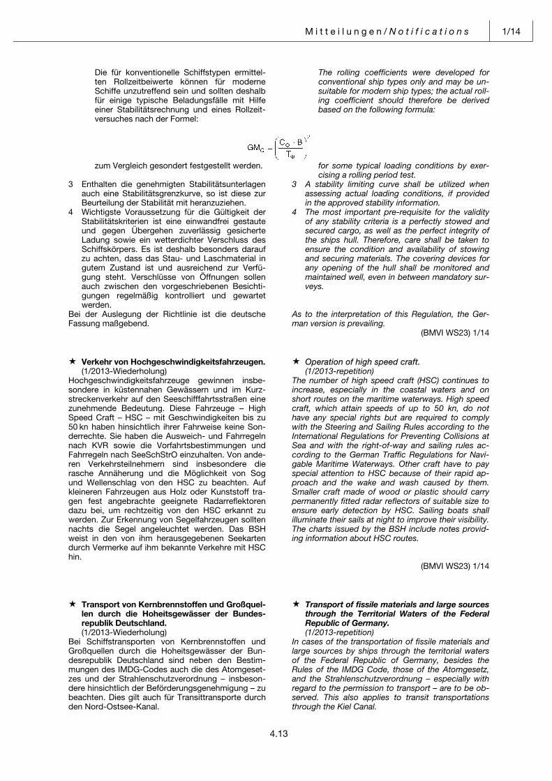
M i t t e i l u n g e n / N o t i f i c a t i o n s 1/14
4.13
Die für konventionelle Schiffstypen ermittel-ten Rollzeitbeiwerte können für moderne Schiffe unzutreffend sein und sollten deshalb für einige typische Beladungsfälle mit Hilfe einer Stabilitätsrechnung und eines Rollzeit-versuches nach der Formel:
The rolling coefficients were developed for conventional ship types only and may be un-suitable for modern ship types; the actual roll-ing coefficient should therefore be derived based on the following formula:
zum Vergleich gesondert festgestellt werden. for some typical loading conditions by exer-cising a rolling period test.
3 Enthalten die genehmigten Stabilitätsunterlagen auch eine Stabilitätsgrenzkurve, so ist diese zur Beurteilung der Stabilität mit heranzuziehen.
3 A stability limiting curve shall be utilized when assessing actual loading conditions, if provided in the approved stability information.
4 Wichtigste Voraussetzung für die Gültigkeit der Stabilitätskriterien ist eine einwandfrei gestaute und gegen Übergehen zuverlässig gesicherte Ladung sowie ein wetterdichter Verschluss des Schiffskörpers. Es ist deshalb besonders darauf zu achten, dass das Stau- und Laschmaterial in gutem Zustand ist und ausreichend zur Verfü-gung steht. Verschlüsse von Öffnungen sollen auch zwischen den vorgeschriebenen Besichti-gungen regelmäßig kontrolliert und gewartet werden.
4 The most important pre-requisite for the validity of any stability criteria is a perfectly stowed and secured cargo, as well as the perfect integrity of the ships hull. Therefore, care shall be taken to ensure the condition and availability of stowing and securing materials. The covering devices for any opening of the hull shall be monitored and maintained well, even in between mandatory sur-veys.
Bei der Auslegung der Richtlinie ist die deutscheFassung maßgebend.
As to the interpretation of this Regulation, the Ger-man version is prevailing.
(BMVI WS23) 1/14 Pos: 10 /NfS/Mitteilungen/jährliches Heft 1/09_Verkehr von Hochgeschwindigkeitsfahrzeugen @ 0\mod_1382431164010_6.docx @ 3657 @ @ 1
Verkehr von Hochgeschwindigkeitsfahrzeugen. Operation of high speed craft. (1/2013-Wiederholung) (1/2013-repetition)Hochgeschwindigkeitsfahrzeuge gewinnen insbe-sondere in küstennahen Gewässern und im Kurz-streckenverkehr auf den Seeschifffahrtsstraßen eine zunehmende Bedeutung. Diese Fahrzeuge – High Speed Craft – HSC – mit Geschwindigkeiten bis zu 50 kn haben hinsichtlich ihrer Fahrweise keine Son-derrechte. Sie haben die Ausweich- und Fahrregeln nach KVR sowie die Vorfahrtsbestimmungen und Fahrregeln nach SeeSchStrO einzuhalten. Von ande-ren Verkehrsteilnehmern sind insbesondere die rasche Annäherung und die Möglichkeit von Sog und Wellenschlag von den HSC zu beachten. Auf kleineren Fahrzeugen aus Holz oder Kunststoff tra-gen fest angebrachte geeignete Radarreflektoren dazu bei, um rechtzeitig von den HSC erkannt zu werden. Zur Erkennung von Segelfahrzeugen sollten nachts die Segel angeleuchtet werden. Das BSH weist in den von ihm herausgegebenen Seekarten durch Vermerke auf ihm bekannte Verkehre mit HSC hin.
The number of high speed craft (HSC) continues to increase, especially in the coastal waters and on short routes on the maritime waterways. High speed craft, which attain speeds of up to 50 kn, do not have any special rights but are required to comply with the Steering and Sailing Rules according to the International Regulations for Preventing Collisions at Sea and with the right-of-way and sailing rules ac-cording to the German Traffic Regulations for Navi-gable Maritime Waterways. Other craft have to pay special attention to HSC because of their rapid ap-proach and the wake and wash caused by them. Smaller craft made of wood or plastic should carry permanently fitted radar reflectors of suitable size to ensure early detection by HSC. Sailing boats shall illuminate their sails at night to improve their visibility. The charts issued by the BSH include notes provid-ing information about HSC routes.
(BMVI WS23) 1/14 Pos: 11 /NfS/Mitteilungen/jährliches Heft 1/10_Transport von Kernbrennstoffen @ 0\mod_1382433418270_6.docx @ 3660 @ @ 1
Transport von Kernbrennstoffen und Großquel-len durch die Hoheitsgewässer der Bundes-republik Deutschland.
Transport of fissile materials and large sources through the Territorial Waters of the Federal Republic of Germany.
(1/2013-Wiederholung) (1/2013-repetition)Bei Schiffstransporten von Kernbrennstoffen und Großquellen durch die Hoheitsgewässer der Bun-desrepublik Deutschland sind neben den Bestim-mungen des IMDG-Codes auch die des Atomgeset-zes und der Strahlenschutzverordnung – insbeson-dere hinsichtlich der Beförderungsgenehmigung – zu beachten. Dies gilt auch für Transittransporte durch den Nord-Ostsee-Kanal.
In cases of the transportation of fissile materials and large sources by ships through the territorial waters of the Federal Republic of Germany, besides the Rules of the IMDG Code, those of the Atomgesetz, and the Strahlenschutzverordnung – especially with regard to the permission to transport – are to be ob-served. This also applies to transit transportations through the Kiel Canal.
1/14 M i t t e i l u n g e n / N o t i f i c a t i o n s
4.14
Nähere Einzelheiten über Transportgenehmigungen und Anmeldungen können bei dem Bundesamt für Strahlenschutz Postfach 10 01 49 38201 Salzgitter Tel.: +49 (0) 30 18 33 30 Fax: +49 (0) 30 1 83 33 18 85 erfragt werden.
More detailed information about permission to transport and notifications can be ascertained from the Bundesamt für Strahlenschutz P.O. Box 10 01 49 38201 Salzgitter Phone: +49 (0) 30 18 33 30 Fax: +49 (0) 30 1 83 33 18 85.
(BMVI UI33) 1/14 Pos: 12 /NfS/Mitteilungen/jährliches Heft 1/11_Ausstellung von Flaggenzertifikaten @ 0\mod_1382503354663_6.docx @ 3663 @ @ 1
Ausstellung von Flaggenzertifikaten. Issuance of Flag Certificates. (1/2013-Wiederholung) (1/2013-repetition)Immer mehr Länder verlangen für das Befahren ihrer Hoheitsgewässer, dass Schiffe unter ausländischer Flagge, jetzt auch Segel- und Motorjachten, durch amtliche Papiere ihr Recht zur Führung ihrer Flagge nachweisen.
A growing number of countries require foreign flagged vessels in their territorial waters to carry offi-cial documents confirming that they are authorized to fly their national flag. This requirement now also covers sailing and motor yachts.
Es wird darauf hingewiesen, dass nach § 3 Buch-stabe d des Flaggenrechtsgesetzes in Verbindung mit den §§ 14 bis 18 der Flaggenrechtsverordnung für nicht im Schiffsregister eintragungspflichtige deutsche Schiffe (bis 15 m Rumpflänge) auf Antrag vom Bundesamt für Seeschifffahrt und Hydrographie in Hamburg, Bernhard-Nocht-Straße 78, 20359 Ham-burg, ein Flaggenzertifikat ausgestellt wird, das als amtlicher Ausweis für das Flaggenführungsrecht des betreffenden Schiffes gilt (vgl. Art. 5 des Hohe-See-Übereinkommens, BGBl. 1972 II S. 1089 bzw. Art. 91 des Seerechtsübereinkommens der Vereinten Nationen vom 2. September 1994, BGBl. II S. 1798). Die rechtzeitige Antragstellung ist empfehlenswert, um etwaige saisonbedingte Wartezeiten zu vermei-den.
It should be noted that Flag Certificates officially authorizing German vessels for which entry in the Ship’s Registry is not mandatory (up to 15 metres hull length) to fly the German flag in accordance with para. 3 lit. d Law of the Flags and para. 14 to 18 Ordinance of the Flags will be issued on request by Bundesamt für Seeschifffahrt und Hydrographie, Bernhard-Nocht-Straße 78, 20359 Hamburg (see Art. 5, Convention on the High Seas, Federal Law Gazette 1972, II p. 1089, and Art. 91, United Nations Convention on the Law of the Sea of 2 September 1994, Federal Law Gazette II, p. 1798). Applications should be submitted in time before the beginning of the season to avoid delays.
Die Mitnahme eines Flaggenzertifikats bei Fahrten ins Ausland und auf der Hohen See kann bei Kon-trollen ausländischer Behörden geeignet sein, unnö-tige Nachfragen und Unannehmlichkeiten zu erspa-ren, und dient in vielen Fällen als Hilfe bei der Erlangung des diplomatischen Schutzes.
Carriage of a Flag Certificate in foreign waters and on the High Seas is advisable in case of inspections by foreign authorities as it may prevent unnecessary inquiries and delays and often facilitates obtaining diplomatic protection.
(BMVI WS20) 1/14 Pos: 13 /NfS/Mitteilungen/jährliches Heft 1/12_Verpflichtung zur Auskunftserteilung @ 0\mod_1382505010640_6.docx @ 3666 @ @ 1
Verpflichtung zur Auskunftserteilung. Obligation to provide information. (1/2013-Wiederholung) (1/2013-repetition)Der Fahrzeugführer eines Schiffes, das berechtigt ist, die Bundesflagge zu führen und das sich in der ausschließlichen Wirtschaftszone (AWZ) oder dem Küstenmeer eines anderen Staates befindet, hat den zuständigen Behörden dieses Küstenstaates auf Anforderung Angaben über die Identität und den Registerhafen sowie den letzten oder nächsten Anlaufhafen seines Schiffes zu übermitteln und an-dere sachdienliche Auskünfte im Zusammenhang mit einem möglichen Verstoß gegen internationale Regeln und Normen zur Verhütung, Verringerung und Überwachung der Verschmutzung durch Schiffe zu erteilen (§ 7a Abs. 1 der Verordnung zu den Inter-nationalen Regeln von 1972 zur Verhütung von Zusammenstößen auf See).
The master of a ship that is entitled to fly the German flag and is navigating in the Exclusive Economic Zone (EEZ) or territorial waters of a foreign state is required to provide to the competent authorities of the coastal state, upon request, information about the ship’s identity, port of registry, last and next ports of call as well as any other relevant information that may be required in connection with possible vio-lations of international rules and standards to pre-vent, reduce and control pollution of the marine envi-ronment from vessels (Art. 7a, para. 1 of the Ordinance implementing the International Regula-tions for Preventing Collisions at Sea, 1972).
(BMVI WS23) 1/14 Pos: 14 /NfS/Mitteilungen/jährliches Heft 1/13_Wachdienst auf Seeschiffen @ 0\mod_1382505447546_6.docx @ 3669 @ @ 1
M i t t e i l u n g e n / N o t i f i c a t i o n s 1/14
4.15
Wachdienst auf Seeschiffen. Besetzung des Ausgucks. Benutzung des Wachalarms.
Watchkeeping on seagoing vessels. Manning of the lookout. Use of the bridge navigational watch alarm system.
(1/2013-Wiederholung) (1/2013-repetition)Der verantwortliche nautische Wachoffizier hat dafür zu sorgen, dass der Ausguck bei der Fahrt im Revier sowie in der Zeit von Sonnenuntergang bis Sonnen-aufgang mit einer geeigneten Person besetzt ist (§ 13 Abs. 3 Nr. 2 SchSV).
In pilotage waters and in the time from sunrise to sunset, the officer of the navigational watch is responsible for manning the look-out with a suitable person (Art. 13, para. 3, no. 2, Ship Safety Ordi-nance).
Ebenso ist Regel 5 KVR zu beachten, wonach jedes Fahrzeug jederzeit durch Sehen und Hören sowie durch jedes andere verfügbare Mittel, das den ge-gebenen Umständen und Bedingungen entspricht, gehörigen Ausguck halten muss, der einen vollstän-digen Überblick über die Lage und die Möglichkeit der Gefahr eines Zusammenstoßes gibt.
Compliance is also required with COLREG Rule 5, according to which every vessel shall at all times maintain a proper lookout by sight and hearing as well as by all available means appropriate in the pre-vailing circumstances and conditions so as to make a full appraisal of the situation and of the risk of colli-sion.
Daneben bestehen die verbindlichen Mindestanfor-derungen (STCW-Code Teil A VIII) und die empfoh-lene Anleitung bezüglich des Wachdienstes (STCW-Code Teil B VIII).
In addition, also the mandatory minimum require-ments (STCW Code, part A VIII) and the recom-mended instructions for watchkeeping (STCW Code, part B VIII) are applicable.
Der verantwortliche nautische Wachoffizier hat dafür zu sorgen, dass die Wachalarmanlage während der Seewache stets benutzt wird. Der Wachalarm darf auch vorübergehend nicht ausgeschaltet werden. Schiffe, deren Kiel nach dem 1. Januar 1998 gelegt worden ist, müssen mit einer fest eingebauten Wachalarmanlage ausgerüstet sein (Anlage 1, C.I.3 Ziff. 4.2 SchSV).
The responsible officer of the navigational watch shall ensure that the bridge navigational watch alarm system is used during navigational watches as a matter of principle. The watch alarm system shall not be switched off, even temporarily. Ships the keel of which is laid after 1 January 1998 must be equipped with a permanently installed watch alarm system (Annex 1, C.I.3, section 4.2, Ship Safety Ordinance).
Ergänzend dazu weist das IMO-Rundschreiben MSC/Circ. 638 vom 26. Mai 1994 darauf hin, dass beim Anordnen sowie der Durchführung des Aus-gucks besonders berücksichtigt werden soll, dass in Gebieten mit hoher Verkehrsdichte, wo größere An-sammlungen von Fischereifahrzeugen und Sport-fahrzeugen angetroffen werden können, diese nicht immer durch Radar entdeckt werden können.
In IMO Circular MSC/Circ.638 of 26 May 1994, it is additionally pointed out that when giving orders for, or maintaining, a lookout, special attention has to be paid to the fact that in congested areas with large numbers of fishing vessels and pleasure craft it may not always be possible to detect them by radar.
(BMVI WS23) 1/14 Pos: 15 /NfS/Mitteilungen/jährliches Heft 1/14_Gefahren bei Manöverabsprachen über UKW @ 0\mod_1382505829101_6.docx @ 3672 @ @ 1
Gefahren bei Manöverabsprachen über UKW. Dangers in the use of VHF radio in collision avoidance.
(1/2013-Wiederholung) (1/2013-repetition)Erfahrungen haben gezeigt, dass Manöverabspra-chen über UKW auf See im Schiff/Schiffsverkehr zur Vermeidung von Kollisionen ursächlich für das Ent-stehen ernster Gefahrensituationen sein können, insbesondere
Past experience has shown that the use of VHF radio by ships to agree manoeuvres in collision avoidance may in fact be the cause of serious risk situations, in particular due to
– durch die Schwierigkeit, ein anderes Fahrzeug auf See eindeutig identifizieren zu können,
– the difficulty of clearly identifying other vessels at sea,
– durch Missverständnisse infolge ungenau über-mittelter Informationen oder durch mangelnde Sprachkenntnisse,
– misunderstandings caused by imprecise com-munication or insufficient language skills,
– durch Manöverabsprachen entgegen den Fahr-und Ausweichregeln der Kollisionsverhütungs-regeln (KVR).
– collision avoidance manoeuvres not complying with the steering and sailing rules of the Regula-tions for Preventing Collisions at Sea.
Außerdem kann in einer Begegnungssituation durch Kontaktaufnahme über UKW-Sprechfunk wertvolle Zeit verloren gehen, die besser für rechtzeitige und durchgreifende Maßnahmen im Sinne der KVR ge-nutzt werden sollte.
Besides, in close-quarters situations, valuable time may be lost in establishing contact on VHF radio, which should be better used to take early and effec-tive action according to the Regulations for Prevent-ing Collisions at Sea.
Bei Maßnahmen zur Abwendung einer Kollision soll-ten sich die Schiffsführungen daher stets bewusst sein, dass Manöverabsprachen über UKW Gefahren in sich bergen, die zu schwerwiegenden Folgen führen können.
When taking action to avoid collision, the vessel’s master should be aware of the fact that collision avoidance action using VHF involves risks and potentially serious consequences.
(BMVI WS23) 1/14 Pos: 16 /NfS/Mitteilungen/jährliches Heft 1/15_Fehlalarme im GMDSS @ 0\mod_1382506956596_6.docx @ 3675 @ @ 1
1/14 M i t t e i l u n g e n / N o t i f i c a t i o n s
4.16
Fehlalarme im Weltweiten Seenot- und Sicher-heitsfunksystem (GMDSS).
False distress alarms in the Global Maritime Distress and Safety System (GMDSS).
(1/2013-Wiederholung) (1/2013-repetition)Die hohe Zahl von Fehlalarmen im GMDSS bedeutet eine beträchtliche, jedoch vermeidbare Belastung der Seenotleitungen (MRCCs). Erhebliche negative Auswirkungen bei der Abwicklung von Notfällen und auf die Sicherheit des menschlichen Lebens auf See können die Folge sein. Um diesen Auswirkungen zu begegnen, hat die Internationale Seeschifffahrts-Organisation (IMO) mit Entschließung A.814 (19) vom 23. November 1995 die „Richtlinien zur Vermeidung von Fehlalarmen“ verabschiedet. Die Richtlinien sind auf den Internetseiten des BSH unter www.bsh.de veröffentlicht.
The large number of false distress alarms in GMDSS imposes a considerable and unnecessary burden on Maritime Rescue Coordination Centres (MRCCs), with potentially very negative effects on the handling of emergencies and the safety of life at sea. To counter these negative effects, the International Maritime Organization (IMO) adopted Resolution A.814 (19) “Guidelines for Avoiding False Distress Alerts” on 23 November 1995. The Guidelines have been published on the BSH’s website www.bsh.de
Die Schifffahrt wird erneut gebeten, diese Veröffent-lichung zu beachten.
Shipping is requested once more to comply with the Guidelines.
(BMVI WS23) 1/14 Pos: 17 /NfS/Mitteilungen/jährliches Heft 1/16_Funktagebuch. Funkstellen an Bord @ 0\mod_1382507081999_6.docx @ 3678 @ @ 1
Funktagebuch. Funkstellen an Bord von See-fahrzeugen, die aufgrund des SOLAS-Über-einkommens mit GMDSS-Funkanlagen ausge-rüstet sind. Übrige Sprech-Seefunkstellen, die zur Führung eines Seetagebuchs verpflichtet sind.
Radio logbook. Radio stations on board marine vessels fitted with GMDSS radiocommunica-tion equipment in accordance with the SOLAS Convention. Other marine radiotelephone sta-tions required to keep a marine logbook.
(1/2013-Wiederholung) (1/2013-repetition)Für – Funkstellen an Bord von Seefahrzeugen, die auf
Grund des SOLAS-Übereinkommens mit GMDSS-Funkanlagen ausgerüstet sein müssen
und für
The following regulations applying to – radio stations on board marine vessels fitted with
GMDSS radiocommunication equipment in ac-cordance with the SOLAS Convention
and to – übrige Sprech-Seefunkstellen an Bord von See-
fahrzeugen, die zur Führung eines Seetagebuchs verpflichtet sind
– other marine radiotelephone stations that are re-quired to keep a marine logbook
gilt ab sofort folgende Regelung: Die Führung eines besonderen Funktagebuchs ist nicht mehr erforderlich. Statt dessen sind gemäß Anhang 16 Abschnitt I Nummer 3 der Vollzugsord-nung für den Funkdienst (RR) folgende Angaben unter Zeitangabe sofort in das Seetagebuch einzu-tragen:
are effective immediately: A special radio logbook no longer has to be kept. Instead, in compliance with Annex 16, section I, number 3, Radio Regulations (RR), the following items must be recorded without delay in the marine logbook, indicating the time:
a) eine Zusammenfassung aller Aussendungen, die
sich auf Not-, Dringlichkeits- und Sicherheitsfälle beziehen;
a) a complete summary of communications relating to distress, urgency or safety traffic;
b) die wichtigen Dienstvorkommnisse in Verbindung
mit dem Funkdienst; b) important incidents connected with the radio ser-
vice; c) ggf., wenn die Bordvorschriften es erlauben, der
Standort des Seefahrzeugs, wenigstens einmal am Tage.
c) the position of the marine vessel at least once a day, if this is in compliance with shipboard regu-lations.
(BMVI WS23) 1/14 Pos: 18 /NfS/Mitteilungen/jährliches Heft 1/17_Mitführen von Handbüchern @ 0\mod_1382507188720_6.docx @ 3681 @ @ 1
Mitführen des Bands III des Internationalen Handbuchs für die luftgestützte und maritime Suche und Rettung (IAMSAR-MANUAL) an Bord von Schiffen.
Carriage of Volume III of the International Aeronautical and Maritime Search and Rescue Manual (IAMSAR Manual) on board ships.
(1/2013-Wiederholung) (1/2013-repetition)Das von der Internationalen Seeschifffahrts-Organisation (IMO) und der Internationalen Zivilen Luftfahrt-Organisation (ICAO) herausgegebene Inter-national Aeronautical and Maritime Search and Res-cue Manual (IAMSAR Manual), Volume III – Mobile
The International Aeronautical and Maritime Search and Rescue Manual (IAMSAR Manual), Volume III – Mobile Facilities, issued by the International Maritime Organization (IMO) and the International Civil Aviation Organization (ICAO) is intended for use
M i t t e i l u n g e n / N o t i f i c a t i o n s 1/14
4.17
Facilities ist zum Gebrauch auf Schiffen bestimmt und enthält Anleitungen für die Bewältigung von Notlagen auf See, um
on board ships. It contains instructions for handling emergency situations at sea in order to be able to
– wirksame Hilfe leisten, – provide assistance effectively, – Such- und Rettungsmaßnahmen koordinieren
oder – coordinate search and rescue activities, or
– Hilfe anderer anfordern zu können. – request assistance.Die IMO empfiehlt, das IAMSAR Manual, Band III an Bord der Schiffe mitzuführen. Das Einhalten der An-leitungen entspricht seemännischer Praxis. Das Feh-len des Manuals kann bei Hafenstaatkontrollen zu Beanstandungen führen.
IMO recommends that ships should carry the IAM-SAR Manual, Volume III. Compliance with the Manu-al represents good seamanship practice. In Port State Control inspections, failure to carry the Manual may be considered non-compliance.
Die Veröffentlichung Nr. 2165 „Suche und Rettung“ des BSH für die Sportschifffahrt, ist eine auszugs-weise Übersetzung des IAMSAR Manuals, Band III in die deutsche Sprache.
BSH publication No. 2165 “Suche und Rettung” for small-craft shipping is a German translation of parts of the IAMSAR Manual, Volume III.
Das Manual, Volume III (IMO Verkaufsnummer: IMO-962E) kann über die Vertriebsstellen des BSH oder über die IMO Publications Section bezogen werden.
The Manual, Volume III (IMO sales no.: IMO-962E) is available from BSH distribution agents or the IMO Publications Section.
(IMO-Resolution A.894(21); BSH N2) 1/14 Pos: 19 /NfS/Mitteilungen/jährliches Heft 1/18_IMO-Standardredewendungen @ 0\mod_1382507339346_6.docx @ 3684 @ @ 1
IMO-Standardredewendungen für die Seefahrt (IMO Standard Marine Communication Phrases [SMCP]).
IMO Standard Marine Communication Phrases (SMCP).
(1/2013-Wiederholung) (1/2013-repetition)Die Standard-Redewendungen sollen in der Kom-munikation Land–Schiff (und umgekehrt) und Schiff–Schiff sowie an Bord mehrsprachig besetzter Fahr-zeuge verwendet werden und auf diese Weise zu einer Basis-Sicherheitssprache werden.
The Standard Marine Communication Phrases are to be used as a standardized safety language in shore-to-ship (and vice-versa) and ship-to-ship communi-cation and on board vessels whose crews speak dif-ferent languages.
Die IMO-Standardredewendungen für die Seefahrt werden vom BSH unter der Bestell-Nr. 2113 vertrie-ben.
The IMO standard marine communication phrases can be ordered from the BSH under order no. 2113.
(BSH N2) 1/14 Pos: 20 /NfS/Mitteilungen/jährliches Heft 1/19_Hinweise für den Seelotsenversetzdienst @ 0\mod_1382507469609_6.docx @ 3687 @ @ 1
Hinweise für den Seelotsenversetzdienst mit Hubschraubern.
Recommendations for the Helicopter Transfer of Marine Pilots.
(1/2013-Wiederholung) (1/2013-repetition)Die Generaldirektion Wasserstraßen und Schifffahrt, Außenstelle Nordwest (vormals Wasser- und Schiff-fahrtsdirektion Nordwest), hat im Auftrag des Bun-desministeriums für Verkehr und digitale Infrastruk-tur die Bekanntmachung „Hinweise für den Seelotsenversetzdienst mit Hubschraubern vom 25. April 2008“ im Verkehrsblatt 2008 S. 314 ver-öffentlicht, die auf den zu bedienenden Schiffen im Rahmen einer Lotsenversetzung mit Hubschraubern von den Piloten der Lotsenversetzhubschrauber und von den sonstigen am Lotsversetzbetrieb beteiligten Personen beachtet werden sollen. Die „Hinweise für den Seelotsenversetzdienst mit Hubschraubern vom 8. Februar 2002“ (VkBl. 2002, S. 212) sind aufgeho-ben. Die aktuellen Hinweise sind im Internet unter http://www.elwis.de/BfS/index.html verfügbar.
The Federal Waterways and Shipping Agency, Northwestern Region Office (former Waterways and Shipping Directorate Northwest), on behalf of the Ministry of Transport and Digital Infrastructure, pub-lished the booklet “Hinweise für den Seelotsen-versetzdienst mit Hubschraubern vom 25 April 2008” (recommendations for the helicopter transfer of ma-rine pilots) in the Gazette of the Federal Ministry of Transport 2008, p.314, superseding the “Hinweise für den Seelotsenversetzdienst mit Hubschraubern vom 8 February 2002” (VkBl. 2002, p. 212). The guidance given in the booklet is directed at ship personnel, helicopter pilots and other per-sons participating in helicopter transfers of marine pilots. Latest information is available at http://www.elwis.de/BfS/index.html
(BSH N2) 1/14 Pos: 21 /NfS/Mitteilungen/jährliches Heft 1/20_Deutschland. Ausrüstung mit nautischen Unterlagen nach der Schiffssicherheitsverordnung @ 0\mod_1382507602357_6.docx @ 3690 @ @ 1
Deutschland. Ausrüstung mit nautischen Un-terlagen nach der Schiffssicherheitsverord-nung.
Germany. Carriage of nautical publications ac-cording to the Schiffssicherheitsverordnung (Ordinance for the Safety of Seagoing Ships).
(1/2013-Wiederholung) (1/2013-repetition)Nach § 13 Abs. 1 Nr. 2 Buchstaben a und c SchSV hat der Eigentümer eines Schiffes dafür zu sorgen, dass auf der Brücke stets die für die jeweilige Reise
Under Art. 13, para. 1, item 2, subparagraphs a and c, Schiffssicherheitsverordnung (SchSV), the shipowner shall ensure that the navigation bridge of
1/14 M i t t e i l u n g e n / N o t i f i c a t i o n s
4.18
erforderlichen amtlichen Ausgaben von Seekarten und Seebüchern und die vom BSH herausgegebe-nen Nachrichten für Seefahrer (NfS) des laufenden und der zwei vorangegangenen Jahre bei Reisean-tritt vorhanden sind. Für Sportboote gelten nach § 2 SchSG die in § 3 SchSG und § 2 SchSV normierten Grundregeln. In Ausfüllung dieser Grundregeln ist der Eigentümer eines Sportbootes dafür verantwort-lich, dass angemessene und auf den neuesten Stand berichtigte Seekarten, Seehandbücher und alle sonstigen für die beabsichtigte Reise erforderli-chen nautischen Veröffentlichungen an Bord mitge-führt werden (§ 7 Nr. 3 SchSG in Verbindung mit Kapitel V Regel 27 SOLAS). Der Schifffahrt wird empfohlen, das Handbuch für Brücke und Karten-haus sowie die „Seeschifffahrtsstraßen-Ordnung mit den Bekanntmachungen der Generaldirektion für Wasserstraßen und Schifffahrt, Außenstellen Nord-west und Nord“ mitzuführen. Das Handbuch enthält Informationen, die für eine sichere Schiffsführung für den Brücken- und Wachdienst von Bedeutung sind und die Schiffsführung darauf hinweisen, erforderli-che Vorsichtsmaßregeln nach Seemannsbrauch zu beachten.
the vessel, whenever she leaves port, is provided with the official issues of the nautical charts and books required for the particular voyage and with the German notices to mariners issued by the BSH, both for the current year and for the preceding two years. Under Art. 2, Schiffssicherheitsgesetz (SchSG, Ship Safety Act), leisure craft shall meet the basic requirements set out in Art. 3, SchSG, and Art. 2, SchSV, according to which the leisure craft owner is responsible for the carriage of up-to-date nautical charts and books as well as any other nauti-cal publications required for the intended voyage (Art. 7, item 3, SchSG in conjunction with Chapter V, Regulation 27, SOLAS). It is recommended that vessels should also carry the “Handbuch für Brücke und Kartenhaus” (bridge and charthouse manual), including the “Seeschifffahrtsstraßen-Ordnung mit den Bekanntmachungen der Generaldirektion für Wasserstraßen und Schifffahrt, Außenstellen Nord-west und Nord” (Traffic Regulations for Navigable Maritime Waterways, including Notices of the Feder-al Waterways and Shipping Agency, Northwestern and Northern Region Offices). The manual provides information concerning bridge and watch duties, which are important to safe navigation, and general advice concerning good seamanship practices.
(BSH N2) 1/14 Pos: 22 /NfS/Mitteilungen/jährliches Heft 1/21_ Anwendung der KVR @ 0\mod_1382517815121_6.docx @ 3693 @ @ 1
Deutschland. Anwendung der Kollisionsverhü-tungsregeln (KVR), der Anlaufbedingungsver-ordnung (AnlBV) und der Seeschifffahrtsstra-ßen-Ordnung (SeeSchStrO).
Germany. Application of the International Regulations for Preventing Collisions at Sea, the Internal Waters (Entering Requirements) Ordinance, and the Traffic Regulations for Navigable Maritime Waterways (Seeschiff-fahrtsstraßen-Ordnung – “SeeSchStrO”).
(Siehe NfS-Heft 1/2013) (See NfS issue 1/2013)1 Die AnlBV gilt für Schiffe, die aus Seegebieten
seewärts der Grenze des deutschen Küstenmee-res kommend die inneren Gewässer der Bundes-republik Deutschland anlaufen, aus diesen aus-laufen oder in diesen verkehren.
1 The Internal Waters (Entering Requirements) Ordinance shall apply to vessels en route from waters seaward of the limit of the German territo-rial sea and bound for the internal waters of the Federal Republic of Germany, vessels leaving these waters and to operating in these waters.
Sie regelt insbesondere die Meldeverpflichtung des Ausrüsters oder Kapitäns eines Schiffes, das gefährliche oder umweltschädliche Güter beför-dert.
The Ordinance stipulates, in particular, the re-porting duties of the operators or masters of ves-sels carrying dangerous or polluting goods.
Die SeeSchStrO gilt auf den Seeschifffahrts-straßen der Bundesrepublik Deutschland mit Ausnahme der Emsmündung. Seeschifffahrts-straßen sind:
The “SeeSchStrO” shall be applicable on the navigable maritime waterways of the Federal Re-public of Germany, with the exception of the Ems Estuary. Navigable maritime waterways have been defined as:
a) die Wasserflächen zwischen der Küstenlinie bei mittlerem Hochwasser oder der seewärti-gen Begrenzung der Binnenwasserstraßen und einer Linie von 3 sm Abstand seewärts der Basislinie,
a) the waters extending between the coastline at mean high water or the seaward delimitation of an inland waterway and a line drawn at a distance of 3 nautical miles seaward of the baseline,
b) die durchgehend durch Sichtzeichen B.11 der Anlage I zur SeeSchStrO begrenzten Wasserflächen der seewärtigen Teile der Fahrwasser im Küstenmeer.
b) the waters of the seaward parts of the fair-ways in the territorial sea that are delimited by the visual aids referred to under Item B.11 of Annex 1 to the “SeeSchStrO”.
Darüber hinaus sind Seeschifffahrtsstraßen die Wasserflächen zwischen den Ufern der in § 1 Abs. 1 SeeSchStrO näher bezeichneten Teile der angrenzenden Binnenwasserstraßen. Im Bereich der Wasserflächen zwischen der seewärtigen Begrenzung der Seeschifffahrtsstraßen nach Buchstabe a) und b) und der seewärtigen Begrenzung des Küstenmeeres findet die
Moreover, the navigable maritime waterways in-clude the waters extending between the banks of those stretches of the adjacent inland waterways that are specified in Section 1 (1) of the “SeeSch-StrO”. In the waters extending between the sea-ward delimitation of the navigable maritime waterways as defined in subparagraphs a) and b) above and the seaward limit of the territorial sea,
M i t t e i l u n g e n / N o t i f i c a t i o n s 1/14
4.19
SeeSchStrO nur eingeschränkt Anwendung. Ins-besondere gelten in diesem Bereich aus-schließlich die Fahrregeln der KVR.
the provisions of the “SeeSchStrO” shall apply only to a limited extent. In particular, it is exclu-sively the Sailing Rules embodied in the Interna-tional Regulations for Preventing Collisions at Sea, 1972, as amended, that shall apply in the said area.
2 Fahrwasser im Sinne der SeeSchStrO sind die Teile der Wasserflächen, die durch die Sichtzei-chen B.11 und B.13 der Anlage I zur SeeSchStrO begrenzt oder gekennzeichnet sind, oder die, soweit dies nicht der Fall ist, auf den Binnen-wasserstraßen für die durchgehende Schifffahrt bestimmt sind.
2 For the purposes of the “SeeSchStrO”, the term “fairways” shall include those waters that are delimited or otherwise buoyed by means of any one or more of the visual aids referred to under Items B.11 and B.13 of Annex I to the “SeeSch-StrO” or, alternatively, that are appropriated to through traffic on the inland waterways.
3 Für den Bereich der inneren Deutschen Bucht ergibt sich folgendes:
3 The following shall apply to the area of the inner German Bight:
a) In den Ansteuerungen zur Jade und Weser beginnt das Fahrwasser von See aus mit den Tonnen TG 7/Weser 1 und TG 9/Weser 2, zur Alten Weser mit den Tonnen A 1 und A 2 und zur Elbe mit den Tonnen 1 und 2.
a) In the approaches to the rivers Jade and Weser, the fairway commences at the buoys TG 7/Weser 1 and TG 9/Weser 2 for vessels proceeding en route from abroad; at buoys A 1 and A 2 for vessels heading for the “Alte Weser” Lighthouse; and at No 1 and No 2 buoys for vessels heading for the river Elbe.
Das Fahrwasser zur Jade zweigt bei den Tonnen 1b/Jade 1 und 3/Jade 2 vom Fahr-wasser zur Weser ab.
The fairway to the river Jade commences at the buoys 1 b/Jade 1 and 3/Jade 2, where it branches off from the fairway to the river Weser.
Innerhalb der vorstehend genannten Fahr-wasser kommen die Bestimmungen der SeeSchStrO, insbesondere folgende Fahr- und Ausweichregeln zur Anwendung:
Within the above mentioned fairways, the provisions of the “SeeSchStrO” shall apply, in particular the following steering and sailing rules:
§ 21 Grundsätze der Schifffahrt im Fahr-wasser,
§ 21 General rules of navigation in fairways,
§ 22 Ausnahmen vom Rechtsfahrgebot, § 22 Exemptions from the obligation to pro-ceed on the right-hand side of the fairways,
§ 23 Überholen, § 23 Overtaking, § 24 Begegnen, § 24 Head-on situations, § 25 Vorfahrt der Schifffahrt im Fahrwasser. § 25 Right-of-way of vessels operating in fair-
ways. b) Innerhalb des Bereiches der Wasserflächen
nach Nr. 1 a) beginnt das Fahrwasser von See aus mit der Fahrwasserseitenbezeich-nung (Sichtzeichen B.11 der Anlage I zur SeeSchStrO).
b) Within the area of the waters referred to in subparagraph (1) (a) above, the fairway is deemed to commence at the first elements of fairway buoyage, as seen by vessels proceed-ing en route from abroad (such elements be-ing visual aids as referred to under Item B.11 of Annex I to the ”SeeSchStrO”).
c) Wasserflächen im Bereich des Wattenmee-res, die nicht durchgehend oder nur zeitweise (z. B. im Sommer) durch Sichtzeichen B.11 und B.13 der Anlage I zur SeeSchStrO begrenzt oder gekennzeichnet sind, sind auch dann Fahrwasser im Sinne der SeeSch-StrO, wenn die Bezeichnung nicht ausliegt oder nur lückenhaft ist.
c) Waters in the area of the Wadden Sea which are not continuously or only temporarily (e. g. in summer) delimited or otherwise buoyed by means of visual aids according to items B.11 and B.13 of Annex I to the ”SeeSch-StrO” are deemed to be fairways for the pur-poses of the “SeeSchStrO” also in the event of incomplete buoyage or buoyage not being laid out at all.
4 Für den Bereich der Ostsee ergibt sich folgen-des:
4 The following shall apply to the area of the Baltic Sea:
a) In der Ansteuerung zur Unterwarnow beginnt das Fahrwasser im Sinne der SeeSchStrO von See aus mit den Tonnen 1 und 2.
a) In the approaches to the lower river Warnow (Unterwarnow), the fairway for the purposes of the “SeeSchStrO” is deemed to com-mence at the No 1 and No 2 buoys, as seen by vessels proceeding en route from abroad.
b) Innerhalb des Bereiches der Wasserflächen nach Nr. 1 a) beginnt das Fahrwasser im Sinne der SeeSchStrO von See aus mit der Fahrwasserseitenbezeichnung.
b) Within the area of the waters specified in subparagraph (1) above, the fairway for the purposes of the “SeeSchStrO” is deemed to commence at the first elements of fairway buoyage for vessels proceeding en route from abroad.
1/14 M i t t e i l u n g e n / N o t i f i c a t i o n s
4.20
c) Im Geltungsbereich der SeeSchStrO sind die mit Sichtzeichen B.10 der Anlage I zur SeeSchStrO bezeichneten und in den See-karten dargestellten Schifffahrtswege
c) The shipping routes marked by visual aids according to Item B.10 of Annex I to the “SeeSchStrO” and depicted on navigational charts
– in der Flensburger Förde von den Tonnen 1 und 2 bis zu den Tonnen 13 und 14,
– in the Flensburg Fjord between buoys 1, 2 and buoys 13, 14,
– im Greifswalder Bodden, – in the “Greifswalder Bodden” inlet, and– im Stettiner Haff – in the “Stettiner Haff” inlet
keine Fahrwasser im Sinne der SeeSchStrO. Hier gelten ausschließlich die Ausweich- und Fahrregeln der KVR.
are not deemed to be fairways for the pur-poses of the “SeeSchStrO”. On the said shipping routes, the Steering and Sailing Rules embodied in the International Regula-tions for Preventing Collisions at Sea, 1972, as amended, shall apply exclusively.
d) Die Schifffahrtswege im Küstenmeer see-wärts des Bereiches der Wasserflächen nach 1 a) und b) bis zur seewärtigen Grenze des Küstenmeeres sind keine Seeschifffahrtsstra-ßen, sodass hier ausschließlich die Aus-weich- und Fahrregeln der KVR gelten.
d) In the German territorial sea, the shipping routes seaward of the waters specified in subparagraphs 1 a) and b) above, up to the outer limit of the territorial sea, are not deemed to be navigable maritime waterways, so that the Steering and Sailing Rules em-bodied in the International Regulations for Preventing Collisions at Sea, 1972, as amended, shall apply exclusively.
5 Im Rahmen des maritimen Verkehrssicherungs-
systems wird der Schiffsverkehr an der deut-schen Ostseeküste und in den angrenzenden Revieren von den Verkehrszentralen überwacht und unterstützt. Wesentlicher Bestandteil der maritimen Verkehrssicherung ist die Verpflich-tung zur Abgabe von Meldungen.
5 Shipping traffic along the German Baltic coast and in the adjacent areas is monitored and sup-ported by the VTS Centres. A mandatory report-ing scheme is an important component of the maritime traffic safety system.
Der Führer eines mit einer UKW-Sprech-
funkanlage ausgerüsteten Fahrzeugs ist ver-pflichtet, bei der Befolgung der Vorschriften über das Verhalten im Verkehr die von einer Verkehrs-zentrale in deutscher, auf Anforderung in engli-scher Sprache gegebenen Verkehrsinformatio-nen und -unterstützungen abzuhören und ent-sprechend den Bedingungen der jeweiligen Verkehrssituation zu berücksichtigen.
The master of any vessel fitted with a VHF radio telephone installation, in observing the relevant provisions on the conduct of his vessel, shall keep listening to the traffic information broad-casts transmitted by a VTS Centre in German or on request, in English language and shall take in-to account such information as appropriate under the prevailing traffic conditions.
Die Führer von Fahrzeugen, Schub- und
Schleppverbänden, die die von den Strom- und Schifffahrtspolizeibehörden für das jeweilige Revier bekannt gemachten Abmessungen und Größen überschreiten, sowie von Fahrzeugen im Sinne des § 30 Abs. 1 SeeSchStrO haben, soweit eine Meldung nach § 1 Abs. 1 in Verbin-dung mit Nummer 2 der Anlage zu § 1 Abs.1 der Anlaufbedingungsverordnung nicht schon vorge-nommen worden ist, der zuständigen Verkehrs-zentrale rechtzeitig folgende Angaben zu melden:
The master of a vessel or of a pushing or towing convoy with dimensions exceeding those defined by the appropriate shipping police authority for the applicable waterway or a vessel as defined in Section 30 (1) of the “SeeSchStrO” shall com-municate the following information to the respon-sible VTS Centre, unless the relevant particulars have already been transmitted according to the provisions of Section 1 (1) of the Internal Waters (Entry Requirements) Ordinance, construed in conjunction with Item 2 of the Annex:
a) Name, Unterscheidungssignal, gegebenen-falls IMO-Schiffsidentifikationsnummer oder Rufnummer des mobilen Seefunkdienstes (Maritime Mobile Service Identity ([MMSI)-Nummer]) und Art des Fahrzeugs, Position des Fahrzeugs, Länge, Breite und aktueller Frischwassertiefgang des Fahrzeugs in Me-tern, letzter Auslauf- und nächster Anlaufha-fen, Angabe, ob verflüssigte Gase, Chemika-lien oder Erdöl-/Erdölprodukte als Massengut befördert werden und, wenn dies zutrifft, An-gabe der Ladungsart und -menge und der UN-Nummer, oder ob solche Güter befördert worden sind und danach die Tanks nicht ge-reinigt und entgast oder vollständig inertisiert sind; Angabe, ob gefährliche oder umwelt-schädliche Güter im Sinne der Anlage zu § 1
a) The vessel’s name; her call sign; her IMO identification number or Maritime Mobile Ser-vice Identity (MMSI) number as required; her type, position, length, beam, and fresh water draught (in metres); her last and next ports of call; a statement to the effect whether liq-uefied gases, chemicals, or petroleum/petro-leum products are carried in bulk and, when this is the case, information on the type, quantity, and UN Number of each cargo, re-spectively, a statement to the effect that such cargoes have been carried and the tanks have not be cleaned and degassed or completely been inerted afterwards; a statement to the effect whether dangerous or polluting goods as referred to in the annex to Section 1, (1) of the Internal Waters (Entry Requirements) Or-
M i t t e i l u n g e n / N o t i f i c a t i o n s 1/14
4.21
Abs. 1 der Anlaufbedingungsverordnung be-fördert werden; Erklärung, ob Mängel an Schiff oder Ladung vorliegen und Gesamtzahl der Personen an Bord.
dinance are carried; a statement to the effect whether there are any deficiencies with re-gard to the vessel or her cargo; the total number of persons on board the vessel.
b) Während der weiteren Fahrt sind bei den be-kannt gemachten Meldepositionen zu mel-den: Name und Unterscheidungssignal des Fahrzeugs, Position des Fahrzeugs, Ge-schwindigkeit des Fahrzeugs und Passierzeit des Fahrzeugs.
b) Throughout the rest of the voyage the vessel shall transmit the following information to the appropriate VTS Centre at the specified reporting points: name and call sign, position, speed and the time of passage at the report-ing points.
c) Unterbrechung und Fortsetzung der Fahrt sind zu melden.
c) Any discontinuation and resumption of the vessel’s voyage shall be reported.
Nach Abgabe der ersten Meldung muss der Füh-
rer eines Fahrzeugs ständig über UKW-Sprechfunk auf den bekannt gemachten UKW-Kanälen und, wenn technisch durchführbar, auf UKW-Kanal 16 empfangsbereit sein.
Having made the first report, the vessel’s master shall be constantly available for radio contact on the VHF channels specified for the waterway and, if technically feasible, on VHF channel 16.
Sind Schiffe mit AIS ausgerüstet und befinden
sich diese in einem bekannt gemachten Bereich, haben die Schiffsführer die Meldungen nach Buchstaben a) und b) über AIS abzugeben. Die Meldung des Namens und der Position hat zu-sätzlich über UKW-Sprechfunk auf den bekannt gemachten UKW-Kanälen zu erfolgen.
In the waters specified hereunder, the navigators of vessels equipped with AIS shall use AIS for making the reports under a) and b) above. The vessel’s name and position shall be reported ad-ditionally by VHF radiotelephony on the channels specified hereunder.
6 Wesentliche Bestandteile des maritimen Ver-
kehrssicherungssystems in der Deutschen Bucht sind die Verpflichtungen der Schifffahrt zur Ab-gabe von Meldungen an den bekannt gemachten Meldepositionen, zur Hörbereitschaft auf den bekannt gemachten UKW-Kanälen und zur Be-rücksichtigung von Verkehrsinformationen und Verkehrsunterstützungen der Verkehrszentrale.
6 Essential elements of the existing vessel traffic system in the German Bight are the mandatory reporting routine when passing the reporting points specified for this purpose, the mandatory listening watch on the VHF channels specified for this purpose, and the obligation to take account of the traffic information and traffic assistance provided by the VTS Centre.
a) Der Schiffsverkehr vor der deutschen Nord-
seeküste und in den angrenzenden Revieren wird durch die in der inneren Deutschen Bucht eingerichtete maritime Verkehrssiche-rung überwacht und unterstützt. Der Führer eines mit einer UKW-Sprechfunkanlage aus-gerüsteten Fahrzeugs ist verpflichtet, bei der Befolgung der Vorschriften über das Verhal-ten im Verkehr die von einer Verkehrszentrale in deutscher, auf Anforderung in englischer Sprache gegebenen Verkehrsinformationen und -unterstützungen abzuhören und ent-sprechend den Bedingungen der jeweiligen Verkehrssituation zu berücksichtigen.
a) Shipping traffic off the German North Sea coast and in the adjacent approaches is being monitored and assisted by the vessel traffic system established in the inner German Bight. The master of any vessel fitted with a VHF ra-dio telephone installation, in observing the relevant provisions on the conduct of his ves-sel, shall keep listening to the traffic infor-mation broadcasts transmitted by a VTS Cen-tre (basically in German but, upon request, in English) and shall take into account such in-formation as appropriate under the prevailing traffic conditions.
b) Der Schiffsführer eines aus W-licher oder N-
licher Richtung die innere Deutsche Bucht anlaufenden Schiffes oder Schub- und Schleppverbandes mit mehr als 300 BRZ hat, unabhängig davon, ob das Verkehrstren-nungsgebiet „German Bight Western Appro-ach“ benutzt wird, beim Passieren des Meri-dians 007° 10’ E oder, aus N-licher oder NW-licher Richtung anlaufend, beim Passieren des Breitenparallels 54° 20’ N, folgende Angaben der Verkehrszentrale „German Bight Traffic“ über UKW-Sprechfunk (UKW-Kanal 79 oder 80) oder ein vorhandenes AIS zu melden.
b) The master of a vessel or of a pushing or towing convoy of a gross tonnage exceeding 300 that approaches the Inner German Bight, irrespective of whether or not using the traffic separation scheme “German Bight Western Approach”, shall, upon passing longitude 007° 10’ E when approaching from a W or N direction, or upon passing latitude 54° 20’ N when approaching from a N or NW direction, transmit the following information to the VTS Centre “German Bight Traffic” via radiotele-phony (VHF channel 79 or 80) or through an AIS, if fitted.
c) Nach Passieren der seewärtigen Grenze des
Küstenmeeres bestehen gemäß § 58 See-SchStrO und der Bekanntmachung der Ge-neraldirektion Wasserstraßen und Schifffahrt, Außenstelle Nordwest, für Fahrzeuge ein-schließlich Schub- und Schleppverbände, die
c) Under the provisions of Section 58 of the “SeeSchStrO” and in accordance with the Notice by the Federal Waterways and Ship-ping Agency, Northwestern Region Office, the reporting duties specified hereunder shall ap-ply to vessels and composite units, whether
1/14 M i t t e i l u n g e n / N o t i f i c a t i o n s
4.22
eine Länge über alles von 50 m und mehr haben, sowie für Fahrzeuge im Sinne des § 30 Abs. 1 SeeSchStrO folgende Melde-pflichten:
pushed or towed, of 50 metres length over all and more as well as to vessels as defined in Section 30 (1) of the “SeeSchStrO” once any such vessel or composite unit has crossed the outer limit of the German territorial sea:
aa) Soweit die Meldung der nachfolgenden Angaben nicht schon nach § 1 Abs. 1 in Verbindung mit Nr. 3.1 der Anlage zur AnlBV abgegeben worden ist, sind recht-zeitig vor dem Befahren der von den Strom- und Schifffahrtspolizeibehörden bekannt gemachten Seeschifffahrtstraßen bei der bekannt gemachten Meldeposition (Passieren der Leuchttonne TG/C) an die Verkehrszentrale „German Bight Traffic“ auf UKW-Kanal 80 zu melden:
aa) The particulars listed below shall be transmitted, on VHF channel 80, to the VTS Centre “German Bight Traffic” in good time prior to navigating on any one of the Navigable Maritime Waterways specified for this purpose by the compe-tent shipping police authority; such re-ports shall be made upon passing the ap-propriate reporting point (light-buoy TG/C) specified hereunder, unless the relevant particulars have already been transmitted under the provisions of Section 1 (1) of the Internal Waters (Entry Requirements) Or-dinance, construed in conjunction with Item 3.1 of the Annex thereto:
Name, Unterscheidungssignal, gegebe-nenfalls IMO-Schiffsidentifikationsnum-mer oder Rufnummer des mobilen See-funkdienstes (Maritime Mobile Service Identity – MMSI-Nummer) und Art des Fahrzeugs, Position des Fahrzeugs, Län-ge, Breite und aktueller Frischwassertief-gang des Fahrzeugs in Metern, letzter Auslauf- und nächster Anlaufhafen, Anga-be, ob verflüssigte Gase, Chemikalien oder Erdöl-/Erdölprodukte als Massengut befördert werden und, wenn dies zutrifft, Angabe der Ladungsart und -menge und der UN-Nummer, oder ob solche Güter befördert worden sind und danach die Tanks nicht gereinigt und entgast oder vollständig inertisiert sind, Angabe, ob ge-fährliche oder umweltschädliche Güter im Sinne der Anlage zu § 1 Abs. 1 der An-laufbedingungsverordnung befördert wer-den, Erklärung, ob Mängel an Schiff oder Ladung vorliegen und Gesamtzahl der Personen an Bord.
The vessel’s name; her distinctive letters; her IMO identification number or Maritime Mobile Service Identity (MMSI) number as required; her type, position, length, beam, and fresh water draught (in metres); her last port of departure and next port of call; a statement to the effect whether liquefied gases, chemicals, or petroleum/petroleum products are carried in bulk and, when this is the case, information on the type, quantity, and UN Number of each cargo, respectively, a statement to the effect that such cargoes have been carried and the tanks have not be cleaned and degassed or completely been inerted afterwards; a statement to the effect whether dangerous or polluting goods as referred to in Section 1, para. 1 of the In-ternal Waters (Entry Requirements) Ordi-nance are carried; a statement to the ef-fect whether there are any deficiencies with regard to the vessel or her cargo; the total number of persons on board the ves-sel.
bb) während der weiteren Fahrt sind bei den bekannt gemachten Meldepositionen an die Verkehrszentrale „German Bight Traffic“ auf UKW-Kanal 80 zu melden: Name und Unterscheidungssignal des Fahrzeugs, Position des Fahrzeugs, Geschwindigkeit des Fahrzeugs und Passierzeit des Fahrzeugs.
bb) the vessel’s name and distinctive letters, position, speed, and the times of her pas-sage at the reporting points specified hereunder shall be transmitted on VHF channel 80 to the VTS Centre “German Bight Traffic” throughout the rest of the vessel’s voyage.
cc) Unterbrechung und Fortsetzung der Fahrt sind zu melden.
cc) any discontinuation and subsequent re-sumption of the vessel’s voyage shall be reported.
Nach Abgabe der ersten Meldung muss der Führer eines Fahrzeugs ständig über UKW-Sprechfunk auf den bekannt gemachten UKW-Kanälen und, wenn technisch durch-führbar, auf UKW-Kanal 16 empfangsbereit sein.
Having made the first report, the vessel’s master shall be constantly available for radio contact on the VHF channels specified here-under and, if technically feasible, on VHF channel 16.
Sind Schiffe mit AIS ausgerüstet und befin-
den sich diese in einem bekannt gemachten Bereich, haben die Schiffsführer die Meldun-gen nach Doppelbuchstaben aa) und bb) über AIS abzugeben. Die Meldung des Na-mens und der Position hat zusätzlich über UKW-Sprechfunk auf den bekannt gemach-ten UKW-Kanälen zu erfolgen.
In the waters specified hereunder, the naviga-tors of vessels equipped with AIS shall use AIS for making the reports under aa) and bb) above. The vessel’s name and position shall be reported additionally by VHF radiotele-phony on the channels specified hereunder.
M i t t e i l u n g e n / N o t i f i c a t i o n s 1/14
4.23
7 Beladene Öl-, Gas- und Chemikalientankschiffe ab einer bestimmten Größe sind verpflichtet, ein- und auslaufend das küstenferne Verkehrstren-nungsgebiet „German Bight Western Approach“ als An- bzw. Auslaufbedingung gemäß Nr. 6 der Anlage zu § 1 Abs. 1 der AnlBV zu benutzen.
7 Item 6 of the Annex to Section 1 (1) of the Inter-nal Waters (Entry Requirements) Ordinance makes it a requirement for laden oil, gas, and chemical tankers of a determined size to use the traffic separation scheme “German Bight West-ern Approach” when entering or leaving.
8 Fahrzeuge, die in den vorausliegenden Revieren
tidegebunden fahren müssen und deshalb das Wegerecht in Anspruch nehmen, gelten als Wegerechtschiffe auf den Fahrtstrecken vom Feuerschiff GB oder von der Tiefwasserreede bis zur Jade, Weser oder Elbe. Sie haben dies der Verkehrszentrale „German Bight Traffic“ auf UKW-Kanal 80 zu melden. Sie gelten als manöv-rierbehinderte Fahrzeuge im Sinne von Regel 3 Buchstabe g KVR und müssen Lichter und Sig-nalkörper nach Regel 27 Buchstabe b KVR füh-ren.
8 Vessels which, on account of draught con-straints, must ride the tide on the Navigable Maritime Waterways they are heading for and must, therefore, exercise the right of way shall be deemed to be “right-of-way vessels” while pro-ceeding en route from light-vessel GB or from the deep-water anchorage to the river Jade, We-ser, or Elbe. Such vessels shall inform the VTS Centre “German Bight Traffic” on VHF chan-nel 80. They shall be deemed to be “vessels restricted in their ability to manoeuvre” in terms of Rule 3 (g) of the International Regulations for Preventing Collisions at Sea, 1972, as amended, and shall exhibit the lights and shapes prescribed by Rule 27 (b) thereof.
Die Schifffahrt wird rechtzeitig über Bewegungen tidegebundener Fahrzeuge von der Verkehrs-zentrale „German Bight Traffic“ in Kenntnis ge-setzt. Diese Sicherheitsmeldung wird im Abstand von 15 Minuten, beginnend jeweils im Anschluss an die Lagemeldung, auf UKW-Kanal 16 ange-kündigt und auf dem UKW-Kanal 79 bzw. 80 ausgestrahlt.
Vessels in the vicinity will be informed in good time by the VTS Centre “German Bight Traffic” on the progress of tide-bound vessels. Such safety broadcasts will be announced at 15-min-ute intervals on VHF channel 16 and transmitted on VHF channel 79 or 80, immediately following the situation report.
Zur Verkehrssicherung in der Jade-Ansteuerung werden einlaufende Großtanker von der Leucht-tonne TG 2/Jade (TSS Terschelling–German Bight und TSS Jade Approach) bis zur Leucht-tonne 19 (Jade) von einem Fahrzeug der Was-serschutzpolizei begleitet. Das Fahrzeug führt das Sichtzeichen Nr. 1 der Anlage II.1 (dauern-des blaues Funkellicht) nach der SeeSchStrO.
To ensure the safety of traffic in the approaches to the river Jade, incoming large tankers will be accompanied between light-buoy TG 2/Jade (TSS Terschelling–German Bight and TSS Jade Approach) and light-buoy 19 (Jade) by a patrol boat of the water police. The patrol boat exhibits the light signal as referred to under Item 1 of An-nex II.1 to the “SeeSchStrO” (continuous blue quick flashing light).
9 Die Kenntnis und Beachtung aller eingeführten
Sicherungsmaßnahmen ist Voraussetzung für einen sicheren und flüssigen Verkehrsablauf. Die wesentlichen, von der Schifffahrt zu beachten-den Regelungen und Sicherheitsmaßnahmen (Schiffswegeführung, Nautischer Warn- und Nachrichtendienst, maritimes Verkehrssiche-rungssystem, Lotsenannahmepflicht) sind in dem VTS Guide Germany (BSH Nr. 2011) sowie in dem „Mariners’ Routeing Guide German Bight“ (BSH-Krt. Nr. 2910) zusammengefasst. Die Nichtbeachtung der Vorschriften kann als Ord-nungswidrigkeit mit einem Bußgeld geahndet werden.
9 Knowledge and observance of all safety measures introduced are prerequisite to a safe and smooth traffic flow. Descriptions of the es-sential rules and safety measures to be observed by vessels (ship’s routeing measures; navigation-al warning and information service; maritime traf-fic control system; mandatory pilotage scheme) have been compiled in the VTS Guide Germany (BSH No 2011) and in the “Mariners’ Routeing Guide German Bight” (BSH Chart No 2910). Fail-ure to observe relevant provisions may be prose-cuted as an administrative offence, and an ad-ministrative fine may be imposed upon anyone failing to observe such provisions.
(BMVI WS23) 1/14 Pos: 23 /NfS/Mitteilungen/jährliches Heft 1/22_PSSA @ 0\mod_1382599923082_6.docx @ 3696 @ @ 1
Besonders empfindliche Meeresgebiete (PSSA).
Particularly Sensitive Sea Area (PSSA).
(Siehe NfS-Heft 1/2013) (See NfS issue 1/2013)Die Internationale Seeschifffahrts-Organisation (IMO) hat weltweit Gewässer als so genannte „Besonders empfindliche Meeresgebiete“ (PSSAs) ausgewiesen. Innerhalb des Bearbeitungsgebietes des BSH sind folgende PSSAs zu beachten:
The International Maritime Organization (IMO) has designated sea areas worldwide as “Particularly Sensitive Sea Areas” (PSSAs). In the area of the BSH’s responsibility, the following PSSAs have been established:
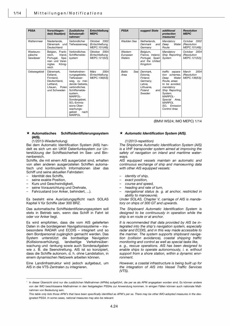
1/14 M i t t e i l u n g e n / N o t i f i c a t i o n s
4.24
PSSA Vorschlagen-
de(r) Staat(en)
Zusätzliche
Schutzmaß-
nahmen1
Entschließung
MEPC
Wattenmeer Niederlande, Dänemark und Deutschland
Verbindlicher Tiefwasserweg
Oktober 2002 (Entschließung MEPC.101(48))
Westeuro-päische Gewässer
Belgien, Frank-reich, Irland, Portugal, Spa-nien und Verei-nigtes König-reich
Verbindliches Schiffsmelde-system
Oktober 2004 (Entschließung MEPC.121(52))
Ostseegebiet Dänemark, Estland, Finnland, Deutschland, Lettland, Litauen, Polen und Schweden
Verkehrstren-nungsgebiete, Tiefwasser-weg, zu mei-dende Gebiete, verbindliches Schiffsmelde-system, MARPOL-Sondergebiet, SOx-Emmis-sions-Über-wachungs-gebiet nach MARPOL
März 2004 (Entschließung MEPC.136(53))
PSSA suggest State additional
protection
measures1
Resolution
MEPC
Wadden Sea Netherlands, Denmark and Germany
Mandatory Deep Water Route
October 2002 (Resolution MEPC.101(48))
Western European Waters
Belgium, France, Ireland, Portugal, Spain and the United Kingdom
Mandatory Ship Reporting System
October 2004 (Resolution MEPC.121(52))
Baltic Sea Area
Denmark,Estonia, Finland, Germany, Latvia, Lithuania, Poland and Sweden
traffic separa-tion schemes, Deep Water Route, areas to be avoided, mandatory Ship Reporting System, MARPOL-Special Area, MARPOL SOx Emission Control Area
March 2004 (Resolution MEPC.136(53))
(BMVI WS24; IMO MEPC) 1/14 Pos: 24 /NfS/Mitteilungen/jährliches Heft 1/23_Automatisches Schiffsidentifizierungssystem (AIS) @ 0\mod_1382600457794_6.docx @ 3699 @ @ 1
Automatisches Schiffsidentifizierungssystem (AIS).
Automatic Identification System (AIS).
(1/2013-Wiederholung) (1/2013-repetition)Bei dem Automatic Identification System (AIS) han-delt es sich um ein UKW Datenfunksystem zur Un-terstützung der Schiffssicherheit im See- und Bin-nenbereich.
The Shipborne Automatic Identification System (AIS) is a VHF transponder system aimed at improving the safety of navigation on inland and maritime water-ways.
Schiffe, die mit einem AIS ausgerüstet sind, erhalten von allen anderen ausgerüsteten Schiffen automa-tisch und kontinuierlich Informationen über das Schiff und seine aktuellen Fahrdaten:
AIS equipped vessels maintain an automatic and continuous exchange of ship and manoeuvring data with other AIS equipped vessels:
– Identität des Schiffs, – identity of ship,– seine exakte Position, – exact position,– Kurs und Geschwindigkeit, – course and speed,– seine Vorausrichtung und Drehrate, – heading and rate of turn, – Fahrzustand (vor Anker, behindert, ...). – navigational status (e. g. at anchor, restricted in
ability to manoeuvre). Es besteht eine Ausrüstungspflicht nach SOLAS Kapitel V für Schiffe über 300 BRZ.
Under SOLAS, Chapter V, carriage of AIS is manda-tory on ships of 300 GT and upwards.
Das automatische Schiffsidentifizierungssystem soll stets in Betrieb sein, wenn das Schiff in Fahrt ist oder vor Anker liegt.
The Shipboard Automatic Identification System is designed to be continuously in operation while the ship is en route or at anchor.
Es wird empfohlen, dass die vom AIS gelieferten Daten in die bordeigenen Navigationssysteme – ins-besondere RADAR und ECDIS – integriert und so dem Bordpersonal zugänglich gemacht werden. Das System unterstützt die bordseitige Navigation (Kollisionsverhütung), landseitige Verkehrsüber-wachung und -lenkung sowie auch Sonderaufgaben wie z. B. die Seenotrettung. AIS ist so konzipiert, dass die Schiffe autonom, d. h. ohne Landstation, in einem dynamischen Netzwerk arbeiten können.
It is recommended that data provided by AIS be in-tegrated into the ship’s navigation system, especially radar and ECDIS, and in this way made accessible to the mariner. The system supports shipboard naviga-tion (collision avoidance), coastal shipping traffic monitoring and control as well as special tasks like, e. g., rescue operations. AIS has been designed to enable ships to operate autonomously, i. e. without support from a shore station, within a dynamic envi-ronment.
Eine Landinfrastruktur wird jedoch aufgebaut, um AIS in die VTS-Zentralen zu integrieren.
However, a coastal infrastructure is being built up for the integration of AIS into Vessel Traffic Services (VTS).
1 In dieser Übersicht sind nur die zusätzlichen Maßnahmen (APMs) aufgeführt, die per se als APM angegeben worden sind. Es können andere
von der IMO beschlossene Maßnahmen in den festgelegten PSSAs zur Anwendung kommen. In einigen Fällen können auch nationale Maß-nahmen von Bedeutung sein.
This table only lists those APM’s that have been specifically identified as APM’s per se. There may be other IMO-adopted measures in the des-ignated PSSA. In some cases, national measures may also be relevant.
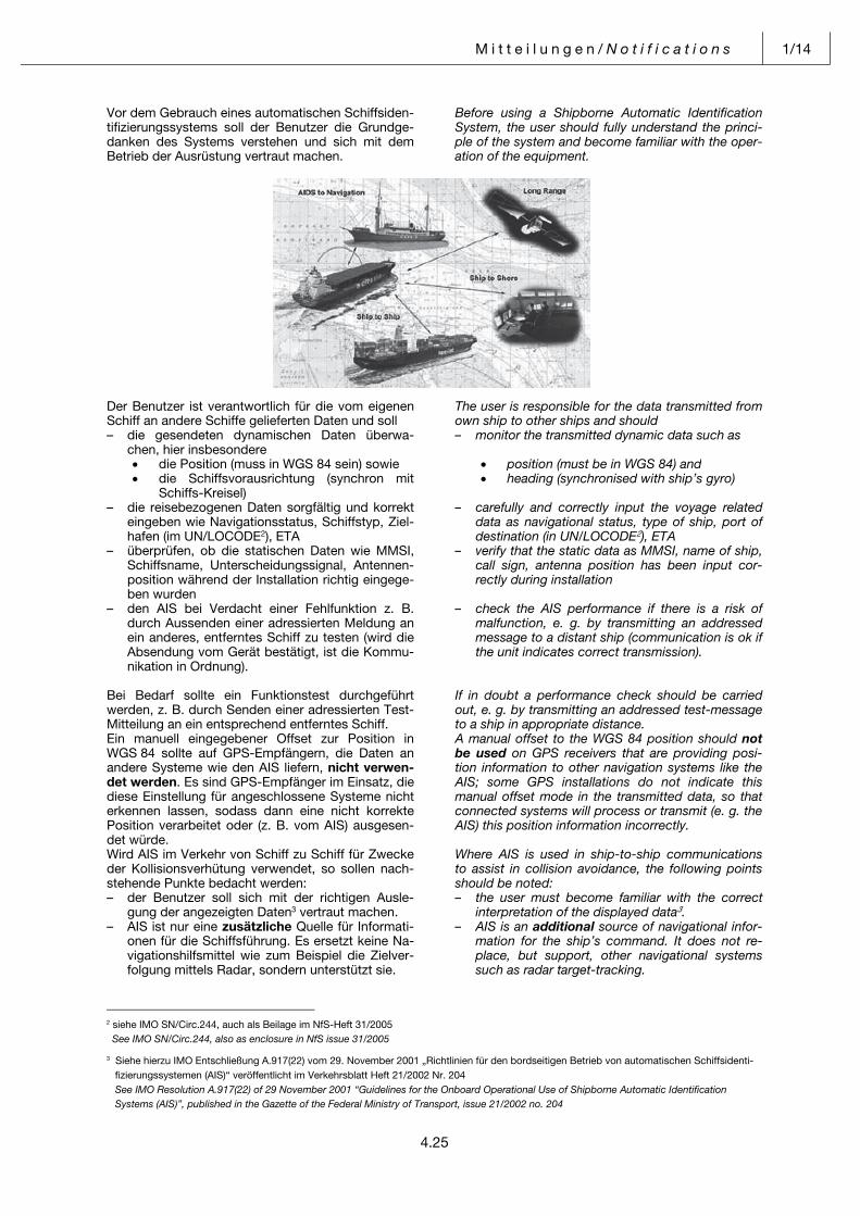
M i t t e i l u n g e n / N o t i f i c a t i o n s 1/14
4.25
Vor dem Gebrauch eines automatischen Schiffsiden-tifizierungssystems soll der Benutzer die Grundge-danken des Systems verstehen und sich mit dem Betrieb der Ausrüstung vertraut machen.
Before using a Shipborne Automatic Identification System, the user should fully understand the princi-ple of the system and become familiar with the oper-ation of the equipment.
Der Benutzer ist verantwortlich für die vom eigenen Schiff an andere Schiffe gelieferten Daten und soll
The user is responsible for the data transmitted from own ship to other ships and should
– die gesendeten dynamischen Daten überwa-chen, hier insbesondere
– monitor the transmitted dynamic data such as
die Position (muss in WGS 84 sein) sowie die Schiffsvorausrichtung (synchron mit
Schiffs-Kreisel)
position (must be in WGS 84) and heading (synchronised with ship’s gyro)
– die reisebezogenen Daten sorgfältig und korrekt eingeben wie Navigationsstatus, Schiffstyp, Ziel-hafen (im UN/LOCODE2), ETA
– carefully and correctly input the voyage related data as navigational status, type of ship, port of destination (in UN/LOCODE2), ETA
– überprüfen, ob die statischen Daten wie MMSI, Schiffsname, Unterscheidungssignal, Antennen-position während der Installation richtig eingege-ben wurden
– verify that the static data as MMSI, name of ship, call sign, antenna position has been input cor-rectly during installation
– den AIS bei Verdacht einer Fehlfunktion z. B. durch Aussenden einer adressierten Meldung an ein anderes, entferntes Schiff zu testen (wird die Absendung vom Gerät bestätigt, ist die Kommu-nikation in Ordnung).
– check the AIS performance if there is a risk of malfunction, e. g. by transmitting an addressed message to a distant ship (communication is ok if the unit indicates correct transmission).
Bei Bedarf sollte ein Funktionstest durchgeführt werden, z. B. durch Senden einer adressierten Test-Mitteilung an ein entsprechend entferntes Schiff.
If in doubt a performance check should be carried out, e. g. by transmitting an addressed test-message to a ship in appropriate distance.
Ein manuell eingegebener Offset zur Position in WGS 84 sollte auf GPS-Empfängern, die Daten an andere Systeme wie den AIS liefern, nicht verwen-det werden. Es sind GPS-Empfänger im Einsatz, die diese Einstellung für angeschlossene Systeme nicht erkennen lassen, sodass dann eine nicht korrekte Position verarbeitet oder (z. B. vom AIS) ausgesen-det würde.
A manual offset to the WGS 84 position should not be used on GPS receivers that are providing posi-tion information to other navigation systems like the AIS; some GPS installations do not indicate this manual offset mode in the transmitted data, so that connected systems will process or transmit (e. g. the AIS) this position information incorrectly.
Wird AIS im Verkehr von Schiff zu Schiff für Zwecke der Kollisionsverhütung verwendet, so sollen nach-stehende Punkte bedacht werden:
Where AIS is used in ship-to-ship communications to assist in collision avoidance, the following points should be noted:
– der Benutzer soll sich mit der richtigen Ausle-gung der angezeigten Daten3 vertraut machen.
– the user must become familiar with the correct interpretation of the displayed data3.
– AIS ist nur eine zusätzliche Quelle für Informati-onen für die Schiffsführung. Es ersetzt keine Na-vigationshilfsmittel wie zum Beispiel die Zielver-folgung mittels Radar, sondern unterstützt sie.
– AIS is an additional source of navigational infor-mation for the ship’s command. It does not re-place, but support, other navigational systems such as radar target-tracking.
2 siehe IMO SN/Circ.244, auch als Beilage im NfS-Heft 31/2005 See IMO SN/Circ.244, also as enclosure in NfS issue 31/2005 3 Siehe hierzu IMO Entschließung A.917(22) vom 29. November 2001 „Richtlinien für den bordseitigen Betrieb von automatischen Schiffsidenti- fizierungssystemen (AIS)“ veröffentlicht im Verkehrsblatt Heft 21/2002 Nr. 204 See IMO Resolution A.917(22) of 29 November 2001 “Guidelines for the Onboard Operational Use of Shipborne Automatic Identification Systems (AIS)”, published in the Gazette of the Federal Ministry of Transport, issue 21/2002 no. 204
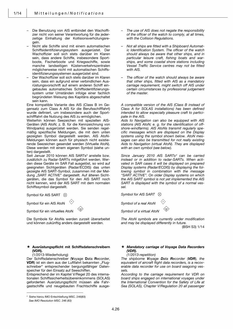
1/14 M i t t e i l u n g e n / N o t i f i c a t i o n s
4.26
– Die Benutzung von AIS entbindet den Wachoffi-zier nicht von seiner Verantwortung für die jeder-zeitige Einhaltung der Kollisionsverhütungsre-geln.
– The use of AIS does not negate the responsibility of the officer of the watch to comply, at all times, with the Collision Regulations.
– Nicht alle Schiffe sind mit einem automatischen Schiffsidentifizierungssystem ausgerüstet. Der Wachoffizier soll sich stets darüber im Klaren sein, dass andere Schiffe, insbesondere Sport-boote, Fischerboote und Kriegsschiffe, sowie manche landseitigen Küstenverkehrszentralen möglicherweise nicht mit automatischen Schiffs-identifizierungssystemen ausgerüstet sind.
– Not all ships are fitted with a Shipboard Automat-ic Identification System. The officer of the watch should always be aware that other ships, and in particular leisure craft, fishing boats and war-ships, and some coastal shore stations including Vessel Traffic Service centres may not be fitted with AIS.
– Der Wachoffizier soll sich stets darüber im Klaren sein, dass ein aufgrund einer verbindlichen Aus-rüstungsvorschrift auf einem anderen Schiff ein-gebautes automatisches Schiffsidentifizierungs-system unter Umständen infolge einer fachlich begründeten Weisung des Kapitäns abgeschaltet sein kann.
– The officer of the watch should always be aware that other ships, fitted with AIS as a mandatory carriage requirement, might switch off AIS under certain circumstances by professional judgement of the master.
Eine kompatible Variante des AIS (Class B im Ge-gensatz zum Class A AIS für die Berufsschifffahrt) wurde definiert, um insbesondere auch der Sport-schifffahrt die Nutzung des AIS zu ermöglichen. Weiterhin können Seezeichen mit speziellen AIS- Geräten (AIS AtoN; z. B. für die Kennzeichnung von Windparks) ausgerüstet werden. Sie senden regel-mäßig spezifische Meldungen, die mit dem unten gezeigten Symbol dargestellt werden. AIS AtoN-Meldungen können auch für physisch nicht existie-rende Seezeichen gesendet werden (Virtuelle AtoN). Diese werden mit einem eigenen Symbol (siehe un-ten) dargestellt.
A compatible version of the AIS (Class B instead of Class A for SOLAS installations) has been defined intended to allow especially pleasure craft to partici-pate in the AIS. Aids to Navigation can also be equipped with AIS stations (AIS AtoN; e. g. for the identification of off-shore-windfarms). AIS AtoNs transmit regularly spe-cific messages which are displayed on the Display systems using the symbol shown below. AtoN mes-sages can also be transmitted for not really existing Aids to Navigation (virtual AtoN). They are displayed with an own symbol (see below).
Seit Januar 2010 können AIS SARTs4 anstelle bzw. zusätzlich zu Radar-SARTs mitgeführt werden. Wer-den diese Geräte im SAR Fall ausgelöst, so wird auf geeigneten Sichtgeräten (Radar/ECDIS) das unten gezeigte AIS SART-Symbol, zusammen mit der Mel-dung „SART ACTIVE“ dargestellt. Auf älteren Sicht-geräten, die das Symbol für den AIS SART noch nicht kennen, wird der AIS SART mit dem normalen Schiffssymbol dargestellt.
Since January 2010 AIS SARTs4 can be carriedinstead or in addition to radar-SARTs. When acti-vated in SAR cases it will be displayed on prepared Display systems (Radar/ECDIS) by displaying the fol-lowing symbol in combination with the message “SART ACTIVE”. On older Display systems on which the AIS SART symbol is not yet implemented the AIS SART is displayed with the symbol of a normal ves-sel.
Symbol für AIS SART {
Symbol for AIS SART {
Symbol für ein AIS AtoN
Symbol für ein virtuelles AtoN
Die Symbole für AtoNs werden zurzeit überarbeitet und können zukünftig anders dargestellt werden.
Symbol of a real AtoN
Symbol of a virtual AtoN
The AtoN symbols are currently under modification and may be displayed differently in future.
(BSH S3) 1/14
Pos: 25 /NfS/Mitteilungen/jährliches Heft 1/24_Ausrüstungspflicht mit Schiffsdatenschreibern @ 0\mod_1382611160697_6.docx @ 3702 @ @ 1
Ausrüstungspflicht mit Schiffsdatenschreibern (VDR).
Mandatory carriage of Voyage Data Recorders (VDR).
(1/2013-Wiederholung) (1/2013-repetition)Der Schiffsdatenschreiber (Voyage Data Recorder, VDR) ist ein dem aus der Luftfahrt bekannten „Flug-schreiber“ entsprechender bergungsfähiger Daten-speicher für den Einsatz auf Seeschiffen.
The shipborne Voyage Data Recorder (VDR), the equivalent of aircraft flight data recorders, is a recov-erable data recorder for use on board seagoing ves-sels.
Entsprechend der im Kapitel V/Regel 20 des interna-tionalen Schiffssicherheitsübereinkommens (SOLAS) geforderten Ausrüstungspflicht müssen alle Fahr-gastschiffe und neugebauten Frachtschiffe ausge-
According to the carriage requirement for VDR on board ships engaged on international voyages under the International Convention for the Safety of Life at Sea (SOLAS), Chapter V/Regulation 20 all passenger
4 Siehe hierzu IMO Entschließung MSC. 246(83) See IMO Resolution MSC. 246 (83)
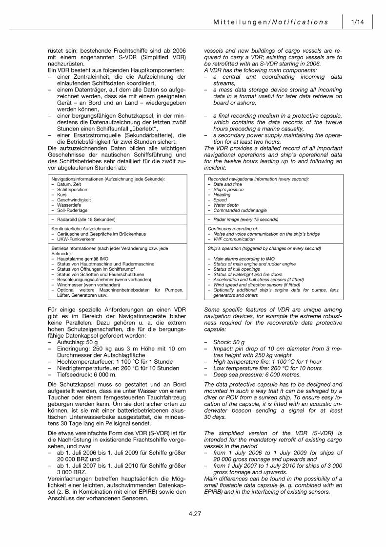
M i t t e i l u n g e n / N o t i f i c a t i o n s 1/14
4.27
rüstet sein; bestehende Frachtschiffe sind ab 2006 mit einem sogenannten S-VDR (Simplified VDR) nachzurüsten.
vessels and new buildings of cargo vessels are re-quired to carry a VDR; existing cargo vessels are to be retrofitted with an S-VDR starting in 2006.
Ein VDR besteht aus folgenden Hauptkomponenten: A VDR has the following main components: – einer Zentraleinheit, die die Aufzeichnung der
einlaufenden Schiffsdaten koordiniert, – a central unit coordinating incoming data
streams, – einem Datenträger, auf dem alle Daten so aufge-
zeichnet werden, dass sie mit einem geeigneten Gerät – an Bord und an Land – wiedergegeben werden können,
– a mass data storage device storing all incoming data in a format useful for later data retrieval on board or ashore,
– einer bergungsfähigen Schutzkapsel, in der min-destens die Datenaufzeichnung der letzten zwölf Stunden einen Schiffsunfall „überlebt“,
– a final recording medium in a protective capsule, which contains the data records of the twelve hours preceding a marine casualty,
– einer Ersatzstromquelle (Sekundärbatterie), die die Betriebsfähigkeit für zwei Stunden sichert.
– a secondary power supply maintaining the opera-tion for at least two hours.
Die aufzuzeichnenden Daten bilden alle wichtigen Geschehnisse der nautischen Schiffsführung und des Schiffsbetriebes sehr detailliert für die zwölf zu-vor abgelaufenen Stunden ab:
The VDR provides a detailed record of all important navigational operations and ship’s operational data for the twelve hours leading up to and following an incident:
Navigationsinformationen (Aufzeichnung jede Sekunde):– Datum, Zeit – Schiffsposition – Kurs – Geschwindigkeit – Wassertiefe – Soll-Ruderlage
– Radarbild (alle 15 Sekunden)
Kontinuierliche Aufzeichnung: – Geräusche und Gespräche im Brückenhaus – UKW-Funkverkehr
Betriebsinformationen (nach jeder Veränderung bzw. jede Sekunde): – Hauptalarme gemäß IMO – Status von Hauptmaschine und Rudermaschine – Status von Öffnungen im Schiffsrumpf – Status von Schotten und Feuerschutztüren – Beschleunigungsaufnehmer (wenn vorhanden) – Windmesser (wenn vorhanden) – Optional weitere Maschinenbetriebsdaten für Pumpen,
Lüfter, Generatoren usw.
Recorded navigational information (every second): – Date and time – Ship’s position – Heading – Speed – Water depth – Commanded rudder angle
– Radar image (every 15 seconds)
Continuous recording of:– Noise and voice communication on the ship’s bridge – VHF communication
Ship’s operation (triggered by changes or every second) – Main alarms according to IMO – Status of main engine and rudder engine – Status of hull openings – Status of watertight and fire doors – Acceleration and hull stress sensors (if fitted) – Wind speed and direction sensors (if fitted) – Optionally additional ship’s engine data for pumps, fans,
generators and others
Für einige spezielle Anforderungen an einen VDR gibt es im Bereich der Navigationsgeräte bisher keine Parallelen. Dazu gehören u. a. die extrem hohen Schutzeigenschaften, die für die bergungs-fähige Datenkapsel gefordert werden:
Some specific features of VDR are unique among navigation devices, for example the extreme robust-ness required for the recoverable data protective capsule:
– Aufschlag: 50 g – Shock: 50 g– Eindringung: 250 kg aus 3 m Höhe mit 10 cm
Durchmesser der Aufschlagfläche – Impact: pin drop of 10 cm diameter from 3 me-
tres height with 250 kg weight – Hochtemperaturfeuer: 1 100 °C für 1 Stunde – High temperature fire: 1 100 °C for 1 hour– Niedrigtemperaturfeuer: 260 °C für 10 Stunden – Low temperature fire: 260 °C for 10 hours– Tiefseedruck: 6 000 m. – Deep sea pressure: 6 000 metres. Die Schutzkapsel muss so gestaltet und an Bord aufgestellt werden, dass sie unter Wasser von einem Taucher oder einem ferngesteuerten Tauchfahrzeug geborgen werden kann. Um sie dort sicher orten zu können, ist sie mit einer batteriebetriebenen akus-tischen Unterwasserbake ausgestattet, die mindes-tens 30 Tage lang ein Peilsignal sendet.
The data protective capsule has to be designed and mounted in such a way that it can be salvaged by a diver or ROV from a sunken ship. To ensure easy lo-cation of the capsule, it is fitted with an acoustic un-derwater beacon sending a signal for at least 30 days.
Die etwas vereinfachte Form des VDR (S-VDR) ist für die Nachrüstung in existierende Frachtschiffe vorge-sehen, und zwar
The simplified version of the VDR (S-VDR) is intended for the mandatory retrofit of existing cargo vessels in the period
– ab 1. Juli 2006 bis 1. Juli 2009 für Schiffe größer 20 000 BRZ und
– from 1 July 2006 to 1 July 2009 for ships of 20 000 gross tonnage and upwards and
– ab 1. Juli 2007 bis 1. Juli 2010 für Schiffe größer 3 000 BRZ.
– from 1 July 2007 to 1 July 2010 for ships of 3 000 gross tonnage and upwards.
Vereinfachungen betreffen hauptsächlich die Mög-lichkeit einer leichten, aufschwimmenden Datenkap-sel (z. B. in Kombination mit einer EPIRB) sowie den Anschluss der vorhandenen Sensoren.
Main differences can be found in the possibility of a small floatable data capsule (e. g. combined with an EPIRB) and in the interfacing of existing sensors.
1/14 M i t t e i l u n g e n / N o t i f i c a t i o n s
4.28
Jederzeit ist es möglich, eine Sicherheitskopie der Daten der letzten 12 Stunden oder mehr zu erstellen. Dieser Datensatz kann an Bord vom VDR ausgele-sen werden, ohne dabei die aktuelle Aufzeichnung zu unterbrechen. Eine Wiedergabe-Software, mit der die Daten zur Auswertung aufbereitet und wiederge-geben werden können, ist ebenfalls an Bord ver-fügbar, sodass sich Untersuchungsbehörden damit einen Überblick zu den Umständen eines Ereignis-ses verschaffen können.
At any time it is possible to initiate an emergency backup with the data of the previous 12 hours or more. These data can be retrieved from the VDR on board without interruption of the recording. A replay software to condition and replay the data is also available on board, to enable investigation authorities to collect information about the circumstances of an event.
Die Wiedergabe kann auch von der Besatzung be-nutzt werden, um sich nach einer Wartung oder Reparatur am VDR oder angeschlossenen Sensoren die einwandfreie Funktion zu prüfen.
The replay can be used by the crew to perform a function check after repair of VDR or connected sen-sors.
Wie Seeunfalluntersuchungen ergeben haben, kommt es immer wieder vor, dass keine oder nur unzureichende Daten vom VDR zur Verfügung ste-hen. Daher sei noch einmal darauf hingewiesen, dass einmal täglich der Status am Bediengerät ab-gelesen werden sollte.
As investigations of accidents have shown there are cases where no or only insufficient data are available from VDR. Therefore it shall be pointed out that the status on the control panel should be checked once per day.
Um einen sicheren Betrieb eines VDR/S-VDR zu gewährleisten und im Unglücksfall eine Sicherheits-kopie anlegen zu können, ist es erforderlich, dass sich die Schiffsführung/Besatzung mit der Funktio-nalität des Gerätes vertraut macht und Hinweise aus dem Benutzerhandbuch beachtet. Wenn keine Datensicherung ausgelöst wird, werden die Daten überschrieben, sodass nach etwa 12 Stunden die Daten nicht mehr zur Verfügung stehen.
To ensure a safe operation of a VDR/S-VDR and in case of an accident the correct initiation of an emer-gency backup it is essential for the bridge team to be familiar with the functionality of the system and to mind the instructions of the user manual. If no emer-gency backup is initialised the data will be overwrit-ten so that after a period of approx. 12 h the data are no longer available.
Eine jährliche Überprüfung des VDR/S-VDR durch qualifiziertes Personal ist vorgeschrieben. Hierbei soll überprüft werden, ob das System noch ein-wandfrei arbeitet und die Batterien noch genügend Kapazität haben, um das System bzw. den Sender über die geforderten Zeiträume mit Energie zu ver-sorgen.
It is required to perform an annual survey of the VDR/S-VDR by qualified personnel. It shall be checked whether the system operates properly and whether the battery capacity is sufficient to ensure the power supply of the system or the transmitter, respectively, for the required period of time.
Am 1. Juli 2014 tritt ein überarbeiteter IMO Leis-tungsstandard für VDRs (MSC.333(90)) in Kraft, der für Neuausrüstungen ab diesem Zeitpunkt anzu-wenden ist. Darin werden sowohl der Umfang der Datenaufzeichnung als auch die Verfügbarkeit deut-lich verbessert.
On 1 July 2014 a revised IMO Performance Stand-ards for VDRs (MSC.333(90)) will come into force, applicable for new installations after that date. Therein the capacity for data recording and availabil-ity are significantly improved.
Im Leistungsstandard sind zwei neue Speicher-medien vorgesehen:
In the Performance Standards two new storage me-dia are defined:
– Eine zusätzliche schwimmfähige Datenschutz-kapsel, die auch die Anforderungen an eine EPIRB erfüllt, sowie
– an additional float free capsule, also fulfilling the requirements for EPIRB, and
– ein Langzeitspeichermedium, das die Daten der letzten 30 Tage vorhält. Dadurch ist die manuelle Auslösung der Datensicherung nicht mehr erfor-derlich.
– a long term storage medium, containing the data of the past 30 days. Thereby the manual initiation of an emergency backup is not further required.
Der Aufzeichnungszeitraum in den Kapseln wird von 12 Stunden auf 48 Stunden erweitert.
The time period for recording data in the capsules will be expanded from 12 h to 48 h.
In Zukunft bietet der VDR eine Selbsttestfunktion, bei der sich der VDR selber analysiert um sicher zu stellen, dass alle vorgeschriebenen Daten richtig aufgezeichnet werden.
Future VDR will provide a self test function analyzingown operation to ensure the proper recording of all required data.
Um die Qualität der Tonaufzeichnung auf der Brücke zu verbessern, wurde ein Kanal hinzugefügt. Außenmikrofone müssen in jedem Fall auf einem zusätzlichen Kanal aufgezeichnet werden.
To improve the quality of audio recording on the bridge on more channel is added. Outside micro-phones have to be recorded on an additional sepa-rate channel.
Zukünftig werden, sofern auf der Brücke vorhanden, Videoaufzeichnungen von zwei Radargeräte durch-geführt und, sofern vorhanden, auch das ECDIS-Video.
In the future video data of two radar systems, if installed on a bridge, and the video of an ECDIS, if installed, will be recorded.
M i t t e i l u n g e n / N o t i f i c a t i o n s 1/14
4.29
Der Status aller vorgeschriebener Alarme auf der Brücke soll so aufgezeichnet werden, dass die Quelle identifizierbar ist.
The status of all alarms required on the bridge shall be recorded in a way to identify the source.
Neigungswinkel und Rollbewegung, sowie das elektronische Logbuch, sofern vorhanden, werden ebenfalls vom VDR gespeichert.
Heel angle and rolling motion as well as electronic logbook data, if available, shall be recorded by VDR.
(BSH S3) 1/14 Pos: 26 /NfS/Mitteilungen/jährliches Heft 1/25_ECDIS-Systeme @ 0\mod_1382677268781_6.docx @ 3708 @ @ 1
Verwendung von ECDIS-Systemen an Bord von Seeschiffen. Hinweis zu Anomalien in der An-zeige.
Carriage of ECDIS systems on board sea-going vessels. Note to display anomalies.
(Siehe NfS-Heft 1/2013) (See NfS issue 1/2013)Amtliche elektronische Seekarteninformationssys-teme – Electronic Chart Display and Information Systems (ECDIS) sind zur Erhöhung der Sicherheit und Leichtigkeit des Verkehrs und des maritimen Umweltschutzes zur Verwendung auf Schiffen unter deutscher Flagge als gleichwertiger Ersatz der Papierseekarten in Übereinstimmung mit Regel 19.2.1.4 Kapitel V SOLAS anerkannt.
Official Electronic Chart Display and Information Sys-tems (ECDIS) improve the safety and efficiency of navigation and contribute to the prevention of marine environmental pollution and are, therefore, recognized as legal equivalents to paper charts in compliance with Regulation 19.2.1.4, Chapter V, of the SOLAS Convention, on vessels flying the German flag.
In Regel 19.2.10 Kapitel V SOLAS ist die stufenweise Einführung einer ECDIS-Ausrüstungspflicht vorgese-hen:
In Regulation 19.2.10, Chapter V; of the SOLAS con-vention a gradual introduction of a mandatory ECDIS carriage requirement is stipulated:
– Fahrgastschiffe von 500 BRZ und mehr, die am oder nach dem 1. Juli 2012 gebaut werden;
– passenger ships of 500 gross tonnage and up-wards constructed on or after 1 July 2012;
– Tankschiffe von 3 000 BRZ und mehr, die am oder nach dem 1. Juli 2012 gebaut werden;
– tankers of 3,000 gross tonnage and upwards constructed on or after 1 July 2012;
– Frachtschiffe, außer Tankschiffe, von 10 000 BRZ und mehr, die am oder nach dem 1. Juli 2013 gebaut werden;
– cargo ships, other than tankers, of 10,000 gross tonnage and upwards constructed on or after 1 July 2013;
– Frachtschiffe, außer Tankschiffe, von 3 000 BRZ und mehr, jedoch weniger als 10 000 BRZ, die am oder nach dem 1. Juli 2014 gebaut werden;
– cargo ships, other than tankers, of 3,000 gross tonnage and upwards but less than 10,000 gross tonnage constructed on or after 1 July 2014;
– Fahrgastschiffe von 500 BRZ und mehr, die vor dem 1. Juli 2012 gebaut worden sind, spätestens bei der ersten Besichtigung5 am oder nach dem 1. Juli 2014;
– passenger ships of 500 gross tonnage and up-wards constructed before 1 July 2012, not later than the first survey5 on or after 1 July 2014;
– Tankschiffe von 3 000 BRZ und mehr, die vor dem 1. Juli 2012 gebaut worden sind, spätestens bei der ersten Besichtigung5 am oder nach dem 1. Juli 2015;
– tankers of 3,000 gross tonnage and upwards constructed before 1 July 2012, not later than the first survey5 on or after 1 July 2015;
– Frachtschiffe, außer Tankschiffe, von 50 000 BRZ und mehr, die vor dem 1. Juli 2013 gebaut worden sind, spätestens bei der ersten Besichti-gung5 am oder nach dem 1. Juli 2016;
– cargo ships, other than tankers, of 50,000 gross tonnage and upwards constructed before 1 July 2013, not later than the first survey5 on or after 1 July 2016;
– Frachtschiffe, außer Tankschiffe, von 20 000 BRZ und mehr, jedoch weniger als 50 000 BRZ, die vor dem 1. Juli 2013 gebaut worden sind, spätestens bei der ersten Besichtigung5 am oder nach dem 1. Juli 2017;
– cargo ships, other than tankers, of 20,000 gross tonnage and upwards but less than 50,000 gross tonnage constructed before 1 July 2013, not later than the first survey5 on or after 1 July 2017;
– Frachtschiffe, außer Tankschiffe, von 10 000 BRZ und mehr, jedoch weniger als 20 000 BRZ, die vor dem 1. Juli 2013 gebaut worden sind, spätestens bei der ersten Besichtigung5 am oder nach dem 1. Juli 2018.
– cargo ships, other than tankers, of 10,000 gross tonnage and upwards but less than 20,000 gross tonnage constructed before 1 July 2013, not later than the first survey5 on or after 1 July 2018.
Die Entscheidung, ob bei der Ausrüstung eines Schiffes mit ECDIS vollständig auf das Mitführen von Papierseekarten verzichtet werden kann, lag laut Beschluss der IMO noch bis 2011 beim Flaggen-staat, nun gilt dies als generell anerkannt. Um die amtliche Papierseekarte an Bord von Seeschiffen vollständig durch ein ECDIS ersetzen zu können oder der Ausrüstungspflicht nachzukommen, müs-sen folgende Voraussetzungen erfüllt sein:
According to IMO, until 2011 the final decision on whether the installation of an ECDIS on a particular vessel fully meets the carriage requirements for nau-tical publications was up to the flag state, now it is approved in general. To be recognized as a full replacement for official paper charts on board sea-going vessels or fulfillment of mandatory carriage requirement, ECDIS must meet the following re-quirements:
5 Bezogen auf die einheitliche Interpretation des Begriff „first survey“ nach den SOLAS-Vorschriften (MSC.1/Circ.1290) Refer to the Unified interpretation of the term “first survey” referred to in SOLAS regulations (MSC.1/Circ.1290
1/14 M i t t e i l u n g e n / N o t i f i c a t i o n s
4.30
1 Die ECDIS-Anlage muss von einer für die Bau-musterprüfung amtlich benannten Stelle gemäß den anwendbaren Anforderungen der IMO und der IEC (International Electrotechnical Commis-sion) geprüft und zugelassen worden sein, und die aktuellen IHO-Normen zur Kartendarstellung erfüllen (s. IMO-Rundschreiben SN.1/Circ.266/Rev.1). Die aktuellen Normen sind auf der IHO-Webseite (http://www.iho.int/mtgdocs/enc/ECDIS-ENCStdsIn_Force.htm) aufgelistet.
1 The ECDIS system must have been type-tested and approved to the applicable IMO and IEC (International Electrotechnical Commission) performance standards by an officially appointed body (“notified body”), and must fulfill the current IHO standards (see IMO ciecular SN.1/Circ.266/Rev.1). The current IHO standards are listed on IHO web page (http://www.iho.int/mtg_docs/enc/ECDIS-ENC_StdsIn_Force.htm).
2 Die ECDIS-Anlage muss für das zu befahrende Seegebiet mit amtlichen ENCs (Electronic Navi-gational Charts) betrieben werden. Amtliche ENC-Daten für Nord- und Mitteleuropa werden im IC-ENC (International Centre for ENCs) in Taunton (Großbritannien) bzw. im Datenzentrum PRIMAR Stavanger (Norwegen) zentral verwaltet (ECDIS-Datendienst siehe nachfolgende Mit-teilung).
2 Use of official ENCs (Electronic Navigational Charts) for the area to be navigated is mandatory with ECDIS. The official ENCs for Northern and Central Europe are held by the data centres IC-ENC (International Centre for ENCs) at Taunton (United Kingdom) and PRIMAR at Stavanger, Norway. (ECDIS data service see fol-lowing information).
3 Stehen für das zu befahrende Seegebiet noch keine amtlichen ENC-Daten zur Verfügung, so kann dort ersatzweise mit amtlichen Rasterdaten im „RCDS-mode“ navigiert werden; jedoch ist für diese Seegebiete in diesem Falle zusätzlich ein reduzierter Satz berichtigter amtlicher Papier-seekarten an Bord mitzuführen. Die Auswahl dieser Seekarten obliegt dem Schiffsführer. Sie soll sich nach folgenden Vorgaben richten:
3 In case official ENC data for the area to be navi-gated are not yet available ECDIS is allowed to be operated in “RCDS mode” using official raster data. However, in this case, a reduced folio of up-to-date official paper charts has to be carried as well. The ship’s master is responsible for selecting suitable charts on the following basis:
– zur Planung der beabsichtigten Reise oder Überfahrt Karten im Maßstab 1 : 750 000 bis 1 : 1 500 000;
– General route appraisal or ocean passage: medium-scale charts in the 1 : 750,000 to 1:1.500,000 range;
– zur Durchführung der geplanten Reise oder Überfahrt auf offener See Karten im Maßstab 1 : 100 000 bis 1 : 500 000;
– General route appraisal or open seas: medi-um-scale charts in the 1 : 100,000 to
1 : 500,000 range; – zur Durchführung der geplanten Reise oder
Durchfahrt in Küstengewässer mit hoher Ver-kehrsdichte oder bei der Ansteuerung von Revieren und Häfen Karten in einem besseren Maßstab als 1 : 100 000.
– General route appraisal or navigation in con-gested coastal waters, pilotage waters or harbour approaches; charts having a scale larger than 1 : 100,000.
4 Die ECDIS-Anlage muss für einen möglichen Ausfall mit geeigneten Rückfalleinrichtungen (Back-up) für die sichere Beendigung der Schiffsreise abgesichert sein. Nach derzeitiger Vorschriftenlage kommt dafür:
4 Suitable back-up arrangements for ECDIS must be provided to ensure safe arrival of the vessel at the port of destination in the event of an ECDIS failure. Under current provisions, the following options are possible:
a) eine Doppelinstallation baugleicher ECDIS-Anlagen oder
a) installation of two identical ECDIS, or
b) eine Installation einer zugelassenen ECDIS-Backup-Anlage zusätzlich zur ECDIS-Anlage oder
b) installation of an approved ECDIS-Backup in addition to the ECDIS or
c) das Mitführen eines vollständigen Satzes berichtigter amtlicher Papierseekarten in Fra-ge.
c) carriage of a complete folio of up-to-date of-ficial paper charts.
Die unter Punkt 3 erhobene Forderung nach dem Mitführen eines reduzierten Satzes aktueller be-richtigter amtlicher Seekarten beim Gebrauch amtlicher Rasterdaten im „RCDS mode“ bleibt davon unberührt. Wird die Forderung nach einer Rückfalleinrichtung jedoch durch die Option 4 c) erfüllt, so kann der reduzierte Kartensatz selbst-verständlich als Teil der Rückfalleinrichtung an-gesehen werden.
The requirement to additionally carry a reduced folio of up-to-date official charts when using offi-cial raster chart data in the “RCDS” mode, refer-red to under point 3 above, is not affected by this provision. If the mandatory back-up arrangement is provided by option 4 c), the reduced chart folio may, of course, be considered part of the back-up system.
5 Entsprechend der Manila Änderungen 2010 zum STCW-Übereinkommen müssen Kapitäne und nautische Schiffsoffiziere einmalig ECDIS-Kom-petenzen entsprechend dem IMO Model Course 1.27 (Edition 2012) nachweisen. Diese Regelung ist am 1. Januar 2012 mit einer Übergangszeit bis 31. Dezember 2016 in Kraft getreten.
5 According to the 2010 Manila amendment to STCW Convention and Code the masters and nautical officers have to show evidence of ECDIS competence according to IMO Model Course 1.27 (Edition 2012) once. This regulation has entereds into force on 1 January 2012 with a transition period until 31 December 2016.
M i t t e i l u n g e n / N o t i f i c a t i o n s 1/14
4.31
Wenn die genannten fünf Voraussetzungen erfüllt sind, bedarf es weder seitens des BSH noch der BG Verkehr einer gesonderten Betriebsgenehmi-gung, um ECDIS-Anlagen anstelle der amtlichen Papierseekarte an Bord einzusetzen.
If all of the five above requirements are met, no addi-tional approvals from the BSH or BG for Traffic and Transport are required for navigational use of ECDIS as a substitute for official paper charts.
IHO – Hinweis zu ECDIS-Anomalien in der An-zeige Bei der Internationalen Hydrographischen Organisa-tion (IHO) sind eine Anzahl von Anomalien in der Darstellung und Alarmierung bei einzelnen ECDIS-Anlagen im Zusammenwirken von Hardware, Soft-ware und Daten identifiziert worden (s. IMO-Rund-schreiben SN.1/Circ.312).
IHO – Note to display anomalies in some ECDIS The International Hydrographic Organization (IHO) has identified a number of anomalies of some ECDIS installations in display and alerting for certain combi-nations of hardware, software and data (see IMO Circular SN.1/Circ.312).
Unter Leitung der IHO werden diese Anomalien mit allen Beteiligten untersucht und bei Bedarf aktuelle Empfehlungen dazu herausgegeben (u. a. IHO-Rundschreiben CL 46/11, CL 91/12).
Under direction of IHO these anomalies will be ex-plored by all parties involved and, if required, rec-ommendations will be published (amongst others IHO Circulars CL 46/11, CL 91/12).
Die IHO und das BSH ermutigt alle ECDIS Anwen-der, falls sie es nicht schon getan haben, ihre ECDIS-Anlagen hinsichtlich Datendarstellung und Leistungsfähigkeit zu überprüfen. Die Daten und Unterlagen für die Prüfung sind weiterhin über die IHO Website www.iho.int verfügbar.
The IHO and BSH to encourage ECDIS users that have not already done so to refer to the ECDIS data presentation and performance check. The data and documentation will remain accessible via the IHO website www.iho.int for the foreseeable future.
(BSH S3/N2) 1/14 Pos: 27 /NfS/Mitteilungen/jährliches Heft 1/26_ECDIS-Datendienst @ 0\mod_1382684045155_6.docx @ 3711 @ @ 1
ECDIS-Datendienst. ECDIS Data Service. (1/2013-Wiederholung) (1/2013-repetition)Amtliche elektronische Seekarteninformationssys-teme – Electronic Chart Display and Information Systems (ECDIS) sind zur Erhöhung der Sicherheit und Leichtigkeit des Verkehrs und des maritimen Umweltschutzes zur Verwendung auf Schiffen unter deutscher Flagge als gleichwertig mit Papierseekar-ten in Übereinstimmung mit Regel 19.2.1.4 Kapitel V SOLAS anerkannt. Voraussetzung für die Verwen-dung von ECDIS sind:
Official Electronic Chart Display and Information Systems (ECDIS) are capable of improving the safety and efficiency of navigation and of contributing to the prevention of pollution of the marine environment and are, therefore, recognized as legal equivalents to up-to-date paper charts in compliance with Regula-tion 19.2.1.4, Chapter V, of the SOLAS Convention, on vessels flying the German flag. The requirements for use of ECDIS are:
– zugelassene ECDIS-Geräte – approved ECDIS system – amtliche Electronic Navigational Charts (ENCs)
und – use of official Electronic Navigational Charts
(ENCs) and – angemessene Redundanzvorrichtung für ECDIS. – appropriate back-up arrangement for ECDIS. Amtliche Raster Chart Display Systems (RCDS) kön-nen in Verbindung mit geeigneten Papierseekarten zur Navigation verwendet werden.
Use of Official Raster Chart Display Systems (RCDS) for navigation is only allowed in combination with adequate paper charts.
Unter dem Sammelbegriff „Electronic Chart System“ (ECS) werden andere Elektronische Seekartensys-teme zusammengefasst, die in der Berufsschifffahrt nur in Verbindung mit herkömmlichen Seekarten für die Navigation eingesetzt werden dürfen. Diese Sys-teme unterliegen nicht den Anforderungen der IMO.
The term “Electronic Chart System” (ECS) desig-nates other types of electronic navigational charts which merchant shipping is only allowed to use in combination with traditional nautical paper charts. Such systems are not subject to the IMO regulations.
Der IHO Transfer Standard for Digital Hydrogra-phic Data (Special Publication No 57, Edition 3.1.1), abgekürzt S-57, ist der internationale Standard für das Datenformat, nach dem ECDIS-Daten herge-stellt und ausgetauscht werden. Ein Datensatz, der dem S-57-Standard entspricht, wird als ENC be-zeichnet.
The IHO Transfer Standard for Digital Hydrogra-phic Data (Special Publication No 57, Edition 3.1.1), or S-57, is the international standard for the data format used to produce and exchange ECDIS data. A data set conforming to the S-57 standard is defined as an ENC.
Die IHO strebt mit ihrem Konzept „Worldwide Electronic Navigational Chart Database (WEND)“ für die Zukunft einen weltweiten ENC-Datendienst an, der ENC-Daten für den internationalen Seever-kehr zur Verfügung stellen soll. Es besteht aus einem Netzwerk regionaler Zentren (Regional Electronic
The IHO concept “Worldwide Electronic Naviga-tional Chart Database (WEND)” is aimed at the development of a future worldwide ENC data service which will provide ENC data to international maritime shipping. It consists of a network of regional centres (Regional Electronic Navigational Chart Coordinating
1/14 M i t t e i l u n g e n / N o t i f i c a t i o n s
4.32
Navigational Chart Coordinating Centre, RENC), die die ENC-Daten der nationalen hydrographischen Dienste sammeln und vertreiben.
Centre, RENC) which collect and distribute the ENC data from the national hydrographic offices.
In Europa gibt es derzeit zwei regionale Zentren:Das durch den britischen Hydrographischen Dienst (United Kingdom Hydrographic Office – UKHO) in Taunton betriebene RENC (IC-ENC) und das durch den norwegischen Hydrographischen Dienst betrie-bene RENC PRIMAR in Stavanger.
There presently exist two RENC in Europe: IC-ENC (International Centre for ENCs) in Taunton, operated by the United Kingdom Hydrographic Of-fice (UKHO) and RENC PRIMAR in Stavanger oper-ated by Norway’s hydrographic office.
Weitere Informationen finden Sie unter: www.ic-enc.org und www.primar.org/
Additional information is available under: www.ic-enc.org and www.primar.org/
(BSH N2) 1/14 Pos: 28 /NfS/Mitteilungen/jährliches Heft 1/27_GNSS – Global Navigation Satellite Systems @ 0\mod_1382684725069_6.docx @ 3714 @ @ 1
GNSS – Global Navigation Satellite Systems. GNSS – Global Navigation Satellite Systems. (Siehe NfS-Heft 1/2013) (See NfS issue 1/2013)Unter der Abkürzung GNSS (Global Navigation Sa-tellite Systems) sind die verschiedenen weltweit nutzbaren Navigationssysteme zusammengefasst, das wohl bekannteste unter den Globalen Naviga-tionssystemen ist das amerikanische GPS, parallel dazu wird das GLONASS-System von Russland be-trieben.
The abbreviation GNSS stands for Global Navigation Satellite Systems and describes different world wide usable navigation systems. A well-known system is the American GPS, but in parallel the Russian oper-ated system GLONASS is also available.
GPS Der Betreiber von GPS ist das amerikanische Vertei-digungsministerium (DoD, Department of Defense), GPS wurde als Mehrzwecksystem mit dem Haupt-ziel der Verbesserung der Effektivität der militäri-schen Kräfte der USA und ihrer Verbündeten ge-plant. Für den zivilen Bereich ist GPS ein wichtiger Bestandteil der entstehenden globalen Informa-tionsinfrastruktur, mit Anwendungen, die von der Kartographie und Geodäsie bis zur Verwaltung des internationalen Luftverkehrs und zu Untersuchungen der weltweiten Klimaveränderung reichen.
GPSThis satellite navigation system, which is operated by the U.S. Department of Defense (DoD), had been de-veloped originally as a multi-purpose system aimed primarily at improving the effectiveness of the mili-tary forces of the USA and its allies. In civilian use, GPS is an important component of the growing global information infrastructure, with applications ranging from cartography and geodesy to the admin-istration of international air traffic and investigations into worldwide climate changes.
Genauigkeiten des GPS. Seit dem 1. Mai 2000 ist die künstliche Verschlechterung der für die öffent-liche Nutzung zur Verfügung stehenden GPS-Signale, die „Selective Availability“ (SA) abgeschal-tet. Dieser Schritt wird mit den wachsenden Anfor-derungen ziviler Bereiche wie Transport, Suche und Rettung sowie Kommunikation an die global verfüg-baren Genauigkeiten von Positionsbestimmungen begründet. Die von den GPS-Betreibern veröffent-lichten durchschnittlichen Genauigkeiten für den Standard-Positioning-Service-Nutzer (SPS) werden mit 13 m horizontal und 22 m vertikal angegeben. Die USA behalten sich das Recht vor, das GPS-Signal regional beeinflussen zu können, wenn dies die nationale Sicherheit der USA erfordert.
Accuracy of GPS. Since 1 May 2000, the signal de-grading system “Selective Availability” (SA) has been out of operation. The reason for switching it off was the growing demands on the global availability and accuracy of position data for civilian applications such as transport, search and rescue, and communi-cations. According to information provided by the operator of the system, the average accuracy availa-ble to users of the Standard Positioning Service (SPS) is approximately 13 metres horizontally and 22 metres vertically. The system is capable of degrading the GPS signal regionally, if required for protection of the national interests of the USA.
DGPS-Nutzung. Die Genauigkeit und Zuverlässig-keit für den SPS-Nutzer kann durch lokale differen-tielle Korrekturverfahren (DGPS) nochmals gesteigert werden.
DGPS use. The accuracy and reliability of the data available to SPS users can be improved by applying local differential GPS methods.
Eine Referenzstation misst an einem geographisch bekannten Ort die jeweiligen aktuellen Fehler der einzelnen Satelliten und stellt sie dem Nutzer als DGPS-Korrekturwerte in einem international stan-dardisierten Format zur Verfügung.
A reference station at a known geographic position measures current errors of the individual satellites and provides the data as DGPS correction values in international standard format.
In Deutschland werden für die Seefahrt drei Refe-renzstationen betrieben, auf Helgoland, in Groß Mohrdorf und in Zeven. Sie haben jeweils eine Reichweite von ca. 180 km. Durch die Nutzung von DGPS kann die Positionsgenauigkeit auf bis zu +/– 3 Meter gesteigert werden.
Three reference stations are operated in Germany: on Helgoland, in Groß Mohrdorf and in Zeven, each with an operational range of approx. 180 km. By using DGPS corrections the SPS position accuracy can be improved up to +/– 3 metres.
M i t t e i l u n g e n / N o t i f i c a t i o n s 1/14
4.33
GLONASS Dem russischen GLONASS (Globalnaya Navi-gatsionnaya Sputnikovaya Sistema) kommt momen-tan im Bereich der zivilen Schifffahrt keine große Bedeutung zu. Das russische System ist, wie das amerikanische GPS, vom Militär betrieben und dient somit im Wesentlichen den russischen Streitkräften.
GLONASSThe Russian GLONASS (Globalnaya Navigatsionnaya Sputnikovaya Sistema) doesn’t play a significant role in maritime civil use. The Russian system is like the American GPS operated by the Russian military and is used mainly by the Russian armed forces.
Bei GLONASS sind seit Bestehen keine künstlichen Verschlechterungen, wie z. B. SA, aktiviert, es steht dem zivilen Nutzer zur Verfügung. Die Positionier-genauigkeit liegt in der gleichen Größenordnung wie beim zivil nutzbaren GPS.
The GLONASS system does not use any artificial degradation of signal, like SA, nor has there been any artificial degradation in the past, although the system is capable of SA and Antispoofing. The GLONASS system is available for civil users and of-fers a positioning service equal to GPS.
Galileo – Ein Projekt der EU Das europäische Großprojekt nimmt Form an, der-zeit sind vier Galileo Satelliten im Orbit und senden seither Galileo konforme Signale von einer Umlauf-bahn in 23 000 km Höhe. In den kommenden Jahren wird die Anzahl der Galileo Satelliten auf 18 erhöht. Im Jahr 2018 wird dann eine Konstellation von 18 Satelliten vorrangig in Europa nutzbar sein, der Endausbau auf 27 Satelliten soll bis 2022 erfolgen.
Galileo – An EU projectOne of the biggest European projects is becoming reality, today four satellites are in space broadcasting Galileo signals from an orbit plane at a height of 23,000 km. Within the upcoming years the number of Galileo satellites will be increased to 18. A constella-tion of 18 satellites will be available by 2018 covering mainly Europe. World-wide coverage will be availa-ble from 2022 with 27 operational satellites.
An dem Galileo Projekt sind zahlreiche Mitglied-staaten der EU, aber auch Länder wie Schweiz, Japan und Israel beteiligt. Die Kontrolle über das Galileo System obliegt dem EU Parlament und ist somit in vollem Umfang in ziviler Kontrolle, der Betreiber übernimmt für die Nutzung von Galileo gegenüber dem Nutzer, eine Funktionsgarantie.
Numerous member states and also countries like Switzerland, Japan and Israel are participating in the Galileo project. The Galileo project is super-vised by the European Parliament – It is under civilian jurisdic-tion. The operator of the Galileo system will provide guarantees for the usage of the Galileo positioning service.
Im Galileo System wird es im Gegensatz zu GPS 10 Navigationssignale geben sowie ebenfalls einen Rückkanal, der für SAR Dienste genutzt werden wird. Die Galileo Integritätsinformation stellt die ein-wandfreie Funktion des Systems für den Nutzer sicher. Es wird einen kommerziellen Dienst (CS commercial service) geben, der die Positionierung im cm-Bereich ermöglicht. Der freie Dienst (OS open service) wird die gleiche Genauigkeit aufweisen wie GPS, durch die zusätzliche Nutzung einer zweiten Frequenz wird es mit Galileo auch möglich, mit zivi-len Empfängern kostenlos genauere Positionen zu bestimmen.
The Galileo system will provide 10 navigation signals from space, also one return path for SAR service. Galileo integrity service will provide reliable infor-mation on the Galileo system status to the user. The Galileo commercial service (CS) is capable of posi-tioning down to the cm level. Galileo open service (OS) provides the same accuracy as GPS does for civil usage, combined with the second Galileo OS frequency precise positioning will be available for civil users at no further costs.
Die differential Dienste, Beacon im 300 kHz See-funkband, sowie die SBAS Dienste werden auf Gali-leo erweitert.
Differential services as the beacon stations, broad-casting in the maritime 300 kHz band, as well as SBAS services will be improved to provide Galileo corrections.
Die Nutzung von kombinierten Galileo/GPS-Empfängern wird die Qualität und die Zuverlässigkeit von Navigationsdaten für diverse maritime und nichtmaritime Anwendungen deutlich verbessern.
The use of combined Galileo/GPS receivers will im-prove the quality and reliability of navigation data used by several maritime and non-maritime applica-tions.
(BSH S3) 1/14 Pos: 29 /NfS/Mitteilungen/jährliches Heft 1/28_Zusammenhang zwischen dem geodätischen Bezug @ 0\mod_1382685832546_6.docx @ 3717 @ @ 1
Zusammenhang zwischen dem geodätischen Bezug von Seekarten und der Positions-genauigkeit von Satelliten-Navigationssys-temen (GNSS).
Relationship between the geodetic reference of charts and the positional accuracy of Global Navigation Satellite Systems (GNSS).
(1/2013-Wiederholung) (1/2013-repetition)Die Positionsangaben von Satelliten-Navigations-empfängern für GPS, GLONASS und zukünftig GALILEO sind auf das geodätische Bezugssystem „World Geodetic System WGS84“ bezogen. WGS84 weicht zum Teil nicht unerheblich von älteren regio-nalen geodätischen Bezugssystemen, die in einigen Seegebieten noch immer für Seekarten angewendet werden, ab. Lagedifferenzen zwischen WGS84 und solchen Bezugssystemen können sowohl in der geo-graphischen Breite als auch in der Länge bis zu 0,3’
The position data supplied by satellite navigation systems for GPS, GLONASS, and in future GALI-LEO, are based on the geodetic reference system “World Geodetic System WGS84”. However, in some respects WGS84 differs considerably from older regional geodetic reference systems, which are still used to chart certain sea areas. There may be differences of up to 0.3’, both in geographic latitude and longitude between WGS84 and such other sys-tems. Besides, as some charts are based on older
1/14 M i t t e i l u n g e n / N o t i f i c a t i o n s
4.34
betragen. Hinzu kommt, dass aufgrund teilweise veralteter Kartengrundlagen die mit Hilfe von Satelli-ten-Navigationssystemen ermittelten Positionen ge-nauer sein können als die kartierten Vermessungen z. B. für den Seegrund, schwimmende und feste Seezeichen, die bebaute Küstenlinie und andere Kartenelemente.
source data, positions determined using satellite navigation systems may be more accurate than charted survey data, e. g. with regard to the sea bot-tom, fixed and floating marks, cultural features on the coastline, and other chart elements.
Die Hydrographischen Dienste sind bemüht, durch entsprechende Vermerke in den Karten Abweichun-gen gegenüber dem WGS bekannt zu geben. In den elektronischen Rasterkarten (z. B. ARCS des briti-schen Hydrographischen Dienstes) sind Korrektur-daten hinterlegt, die den Unterschied zwischen dem Bezugssystem des GNSS und den Kartendaten au-tomatisch ausgleichen.
The Hydrographic Offices include notes in their charts informing users about deviations from WGS. Electronic raster charts (e. g. ARCS of UK Hydro-graphic Office) contain internal correction data which automatically compensate differences between the GNSS reference system and the chart data.
Nicht immer ist für das auf Seekarten verwendete Bezugssystem eine Beschickung zu WGS84 ausge-wiesen bzw. werden aufgrund des Alters der Kar-tengrundlagen keine Angaben zum geodätischen Bezugssystem gemacht. In diesen Fällen, also bei vagen oder fehlenden Angaben hinsichtlich des Bezugssystems in den Karten, ist immer von den ungünstigsten Verhältnissen auszugehen.
Charts using a particular reference system some-times contain no correction for WGS84 or there may be no information at all about the geodetic reference system used due to the age of the source material. In such cases, where only vague information on the chart reference system is available, or none at all, navigation should always be based on the unfavorable assumption.
(BSH N2) 1/14 Pos: 30 /NfS/Mitteilungen/jährliches Heft 1/29_Umstellung des Seekartennulls (SKN-LAT) @ 0\mod_1382686322778_6.docx @ 3720 @ @ 1
Deutschland. Umstellung des Seekartennulls mit Bezug auf den niedrigstmöglichen Gezei-tenwasserstand (SKN-LAT) in den amtlichen Seekarten der Bundesrepublik Deutschland abgeschlossen.
Germany. Change to Lowest Astronomical Tide (LAT) as Chart Datum for the official nautical charts of the Federal Republic of Germany completed.
(Siehe NfS-Heft 1/2013) (See NfS issue 1/2013)Bis Ende 2004 war das Niveau des Seekartennulls (SKN) im Bereich der deutschen Nordseeküste und der angrenzenden Tidegewässer auf der Höhe des mittleren Springniedrigwassers (MSpNW) festgelegt. Seit dem 1. Januar 2005 ist das SKN auf das Niveau des niedrigstmöglichen Gezeitenwasserstandes (Lowest Astronomical Tide, LAT) umgestellt. Durch diese Neufestsetzung wurde der Bezugshorizont „Seekartennull“ in den genannten Gebieten um etwa 0,3–0,6 m abgesenkt. Die Umstellung erfolgte in Umsetzung eines Beschlusses der International Hydrographic Organization (IHO) von 1993, der die Angleichung der Bezugshorizonte aller Nordsee-anrainerstaaten zum Ziel hatte.
Until the end of 2004, Mean Low Water Springs (MLWS) was used as Chart Datum for nautical charts of the German North Sea coast and adjacent tidal waters. On 1 January 2005, the level of the Lowest Astronomical Tide (LAT) was established as Chart Datum, which is 0.3–0.6 m lower than MLWS at most German tide stations. The change from MLWS to LAT was made to implement a resolution of the In-ternational Hydrographic Organization (IHO) of 1993 which was aimed at harmonizing the Chart Datums of all North Sea states.
Umstellung ist abgeschlossen: Die amtlichen Seekarten und die Karten für die Klein- und Sportschifffahrt des Bundesamtes für Seeschifffahrt und Hydrographie (BSH) sind mit der letzten Karte 50 Deutsche Bucht 2013 abschließend auf LAT umgestellt worden.
Change is completed:With the last chart 50 Deutsche Bucht all nautical charts and small-craft charts issued by Bundesamt für Seeschifffahrt und Hydrographie (BSH) have been changed to LAT finally in 2013.
Weitergehende Informationen, Kontaktadressen:Das BSH hat in Zusammenarbeit mit der Generaldi-rektion Wasserstraßen und Schifffahrt, Außenstellen Nord und Nordwest (vormals WSDen Nordwest und Nord) ein kostenloses Faltblatt in deutscher Sprache herausgegeben, in dem über die Umstellung des Seekartenhorizontes informiert wird. Dieses Faltblatt wird in deutscher und englischer Sprache auch im Internet bereit gestellt und kann unter folgender Adresse abgerufen werden:
Further information and addresses: A German-language leaflet informing about the change of Chart Datum, prepared in co-operation with the Federal Waterways and Shipping Agency, Nord and Northwest Region Office (former regional Waterways and Shipping Directorates), is available from the BSH free of charge. German and English language versions of the leaflet are also available on the Internet at:
http://www.bsh.de/de/Produkte/Infomaterial/Seekar-tennull/index.jsp
http://www.bsh.de/en/Products/Information_mate-rial/Chart_Sounding_Datum/index.jsp
(BSH N2) 1/14 Pos: 31 /NfS/Mitteilungen/jährliches Heft 1/30_Bekanntmachung über die von der IMO beschlossenen verbindlichen Schiffsmeldesysteme @ 0\mod_1382687442416_6.docx @ 3723 @ @ 1
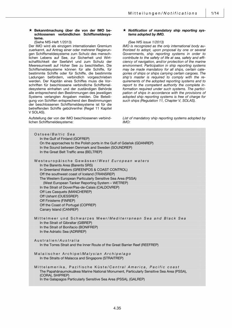
M i t t e i l u n g e n / N o t i f i c a t i o n s 1/14
4.35
Bekanntmachung über die von der IMO be-schlossenen verbindlichen Schiffsmeldesys-teme.
Notification of mandatory ship reporting sys-tems adopted by IMO.
(Siehe NfS-Heft 1/2013) (See NfS issue 1/2013)Der IMO wird als einzigem internationalen Gremium zuerkannt, auf Antrag einer oder mehrerer Regierun-gen Schiffsmeldesysteme zum Schutz des mensch-lichen Lebens auf See, zur Sicherheit und Wirt-schaftlichkeit der Seefahrt und zum Schutz der Meeresumwelt auf Hoher See zu beschließen. Die Schiffsmeldesysteme können für alle Schiffe, für bestimmte Schiffe oder für Schiffe, die bestimmte Ladungen befördern, verbindlich vorgeschrieben werden. Der Kapitän eines Schiffes muss die Vor-schriften für beschlossene verbindliche Schiffsmel-desysteme einhalten und der zuständigen Behörde alle entsprechend den Bestimmungen des jeweiligen Systems verlangten Angaben melden. Die Beteili-gung von Schiffen entsprechend den Bestimmungen der beschlossenen Schiffsmeldesysteme ist für die betreffenden Schiffe gebührenfrei (Regel 11 Kapitel V SOLAS).
IMO is recognized as the only international body au-thorized to adopt, upon proposal by one or several Governments, ship reporting systems in order to contribute to the safety of life at sea, safety and effi-ciency of navigation, and/or protection of the marine environment. Participation in ship reporting systems may be made mandatory for all ships, certain cate-gories of ships or ships carrying certain cargoes. The ship’s master is required to comply with the re-quirements of the adopted reporting systems and to report to the competent authority the complete in-formation required under such systems. The partici-pation of ships in accordance with the provisions of adopted ship reporting systems is free of charge for such ships (Regulation 11, Chapter V, SOLAS).
Aufstellung der von der IMO beschlossenen verbind-lichen Schiffsmeldesysteme:
List of mandatory ship reporting systems adopted by IMO:
O s t s e e / B a l t i c S e a In the Gulf of Finland (GOFREP) On the approaches to the Polish ports in the Gulf of Gdańsk (GDANREP) In the Sound between Denmark and Sweden (SOUNDREP) In the Great Belt Traffic area (BELTREP) W e s t e u r o p ä i s c h e G e w ä s s e r / W e s t E u r o p e a n w a t e r s In the Barents Area (Barents SRS) In Greenland Waters (GREENPOS & COAST CONTROL) Off the southwest coast of Iceland (TRANSREP) The Western European Particularly Sensitive Sea Area (PSSA) (West European Tanker Reporting System – WETREP) In the Strait of Dover/Pas-de-Calais (CALDOVREP) Off Les Casquets (MANCHEREP) Off Ushant (OUESSREP) Off Finisterre (FINREP) Off the Coast of Portugal (COPREP) Canary Island (CANREP) M i t t e l m e e r u n d S c h w a r z e s M e e r / M e d i t e r r a n e a n S e a a n d B l a c k S e a In the Strait of Gibraltar (GIBREP) In the Strait of Bonifacio (BONIFREP) In the Adriatic Sea (ADRIREP) A u s t r a l i e n / A u s t r a l i a In the Torres Strait and the Inner Route of the Great Barrier Reef (REEFREP) M a l a i i s c h e r A r c h i p e l /M a l y s i a n A r c h i p e l a g o In the Straits of Malacca and Singapore (STRAITREP) M i t t e l a m e r i k a , P a z i f i s c h e K ü s t e / C e n t r a l A m e r i c a , P a c i f i c c o a s t The Papahānaumokuākea Marine National Monument, Particularly Sensitive Sea Area (PSSA),
(CORAL SHIPREP) In the Galapagos Particularly Sensitive Sea Area (PSSA), (GALREP)
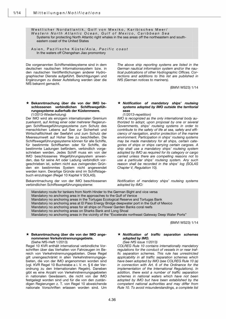
1/14 M i t t e i l u n g e n / N o t i f i c a t i o n s
4.36
W e s t l i c h e r N o r d a t l a n t i k , G o l f v o n M e x i k o , K a r i b i s c h e s M e e r / W e s t e r n N o r t h A t l a n t i c O c e a n , G u l f o f M e x i c o , C a r i b b e a n S e a Systems for protecting North Atlantic right whales in the sea areas off the northeastern and south- eastern coast of the United States
A s i e n , P a z i f i s c h e K ü s t e / A s i a , P a c i f i c c o a s t
In the waters off Chengshan Jiao promontory Die vorgenannten Schiffsmeldesysteme sind in dem deutschen nautischen Informationssystem bzw. in den nautischen Veröffentlichungen anderer Hydro-graphischer Dienste aufgeführt. Berichtigungen und Ergänzungen zu dieser Aufstellung werden über die NfS bekannt gemacht.
The above ship reporting systems are listed in the German nautical information system and/or the nau-tical publications of other Hydrographic Offices. Cor-rections and additions to this list are published in NfS (German notices to mariners).
(BMVI WS23) 1/14 Pos: 32 /NfS/Mitteilungen/jährliches Heft 1/31_Bekanntmachung über die von der IMO beschlossenen verbindlichen Schiffswegeführungssysteme @ 0\mod_1382691779180_6.docx @ 3726 @ @ 1
Bekanntmachung über die von der IMO be-schlossenen verbindlichen Schiffswegefüh-rungssysteme außerhalb der Küstenmeere.
Notification of mandatory ships’ routeing systems adopted by IMO outside the territorial seas
(1/2013-Wiederholung) (1/2013-repetition)Der IMO wird als einzigem internationalen Gremium zuerkannt, auf Antrag einer oder mehrerer Regierun-gen Schiffswegeführungssysteme zum Schutz des menschlichen Lebens auf See zur Sicherheit und Wirtschaftlichkeit der Seefahrt und zum Schutz der Meeresumwelt auf Hoher See zu beschließen. Die Schiffswegeführungssysteme können für alle Schiffe, für bestimmte Schiffsarten oder für Schiffe, die bestimmte Ladungen befördern, verbindlich vorge-schrieben werden. Jedes Schiff muss ein von der IMO beschlossenes Wegeführungssystem anwen-den, das für seine Art oder Ladung verbindlich vor-geschrieben ist, sofern nicht aus zwingenden Grün-den ein bestimmtes System nicht angewendet werden kann. Derartige Gründe sind im Schiffstage-buch einzutragen (Regel 10 Kapitel V SOLAS).
IMO is recognized as the only international body au-thorized to adopt, upon proposal by one or several Governments, ships’ routeing systems in order to contribute to the safety of life at sea, safety and effi-ciency of navigation, and/or protection of the marine environment. Participation in ships’ routeing systems may be made mandatory for all ships, certain cate-gories of ships or ships carrying certain cargoes. A ship shall use a mandatory ships’ routeing system adopted by IMO as required for its category or cargo carried unless there are compelling reasons not to use a particular ships’ routeing system. Any such reason shall be recorded in the ships’ log (SOLAS Chapter V, Regulation 10).
Bekanntmachung der von der IMO beschlossenen verbindlichen Schiffswegeführungssysteme:
Notification of mandatory ships’ routeing systems adopted by IMO:
(BMVI WS23) 1/14 Pos: 33 /NfS/Mitteilungen/jährliches Heft 1/32_Bekanntmachung über die von der IMO angenommenen Verkehrstrennungsgebiete @ 0\mod_1382613808231_6.docx @ 3705 @ @ 1
Bekanntmachung über die von der IMO ange-nommenen Verkehrstrennungsgebiete.
Notification of traffic separation schemes adopted by IMO.
(Siehe NfS-Heft 1/2013) (See NfS issue 1/2013)Regel 10 KVR enthält international verbindliche Vor-schriften über das Verhalten von Fahrzeugen im Be-reich von Verkehrstrennungsgebieten. Diese Regel gilt uneingeschränkt in allen Verkehrstrennungsge-bieten, die von der IMO angenommen worden sind (vgl. KVR Regel 10 Buchstabe a i. V. m. § 6 der Ver-ordnung zu den Internationalen Regeln). Daneben gibt es eine Anzahl von Verkehrstrennungsgebieten in nationalen Gewässern, die nicht von der IMO festgelegt worden sind und für die von den zustän-digen Regierungen z. T. von Regel 10 abweichende nationale Vorschriften erlassen worden sind. Um
COLREG Rule 10 contains internationally mandatory regulations for the conduct of vessels in or near traf-fic separation schemes. This rule has unrestricted applicability in all traffic separation schemes which have been adopted by IMO (see COLREG Rule 10 (a) in connection with Art. 6 of the Ordinance for the implementation of the International Regulations). In addition, there exist a number of traffic separation schemes in national waters which have not been adopted by IMO but have been established by the competent national authorities and may differ from Rule 10. To avoid misunderstandings, a complete list
Mandatory route for tankers from North Hinder to the German Bight and vice versaMandatory no anchoring area in the approaches to the Gulf of Venice Mandatory no anchoring areas in the Tortugas Ecological Reserve and Tortugas Bank Mandatory no anchoring area at El Paso Energy Bridge deepwater port in the Gulf of Mexico Mandatory no anchoring areas for all ships on Flower Garden Banks coral reefs Mandatory no anchoring areas on Sharks Bank and Long Shoal Mandatory no anchoring areas in the vicinity of the “Excelerate northeast Gateway Deep Water Ports”
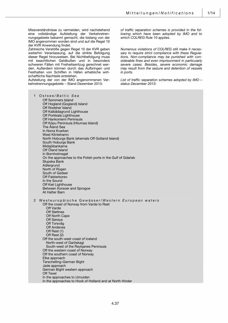
M i t t e i l u n g e n / N o t i f i c a t i o n s 1/14
4.37
Missverständnisse zu vermeiden, wird nachstehend eine vollständige Aufstellung der Verkehrstren-nungsgebiete bekannt gemacht, die bislang von der IMO angenommen worden sind und auf die Regel 10 der KVR Anwendung findet.
of traffic separation schemes is provided in the fol-lowing which have been adopted by IMO and to which COLREG Rule 10 applies.
Zahlreiche Verstöße gegen Regel 10 der KVR geben weiterhin Veranlassung, auf die strikte Befolgung dieser Regel hinzuweisen. Bei Nichtbefolgung muss mit beachtlichen Geldbußen und in besonders schweren Fällen mit Freiheitsentzug gerechnet wer-den. Außerdem können durch das Aufbringen und Festhalten von Schiffen in Häfen erhebliche wirt-schaftliche Nachteile entstehen.
Numerous violations of COLREG still make it neces-sary to require strict compliance with these Regula-tions. Non-compliance may be punished with con-siderable fines and even imprisonment in particularly severe cases. Besides, severe economic damage may result from the seizure and detention of vessels in ports.
Aufstellung der von der IMO angenommenen Ver-kehrstrennungsgebiete – Stand Dezember 2013:
List of traffic separation schemes adopted by IMO –status December 2013:
1 O s t s e e / B a l t i c S e a Off Sommers Island
Off Hogland (Gogland) Island Off Rodsher Island
Off Kalbådagrund Lighthouse Off Porkkala Lighthouse
Off Hankoniemi Peninsula Off Köpu Peninsula (Hiiumaa Island)
The Åland Sea In Norra Kvarken
West Klintehamn North Hoburgs Bank (ehemals Off Gotland Island)
South Hoburgs Bank Midsjöbankarna
Off Öland Island In Bornholmsgat
On the approaches to the Polish ports in the Gulf of Gdańsk Słupska Bank Adlergrund
North of Rügen South of Gedser Off Falsterborev In the Sound
Off Kiel Lighthouse Between Korsoer and Sprogoe At Hatter Barn
2 W e s t e u r o p ä i s c h e G e w ä s s e r / W e s t e r n E u r o p e a n w a t e r s
Off the coast of Norway from Vardø to Røst Off Vardø
Off Slettnes Off North Cape Off Sørøya
Off Torsvåg Off Andenes Off Røst (1) Off Røst (2)
Off the south-west coast of Iceland North-west of Garöskagi South-west of the Reykjanes Peninsula
Off the western coast of Norway Off the southern coast of Norway Elbe approach
Terschelling–German Bight Jade approach
German Bight western approach Off Texel In the approaches to IJmuiden In the approaches to Hook of Holland and at North Hinder
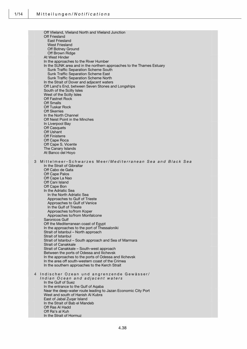
1/14 M i t t e i l u n g e n / N o t i f i c a t i o n s
4.38
Off Vlieland, Vlieland North and Vlieland Junction Off Friesland East Friesland West Friesland Off Botney Ground Off Brown Ridge
At West Hinder In the approaches to the River Humber In the SUNK area and in the northern approaches to the Thames Estuary Sunk Traffic Separation Scheme South Sunk Traffic Separation Scheme East Sunk Traffic Separation Scheme North
In the Strait of Dover and adjacent waters Off Land’s End, between Seven Stones and Longships South of the Scilly Isles West of the Scilly Isles
Off Fastnet Rock Off Smalls Off Tuskar Rock Off Skerries In the North Channel Off Neist Point in the Minches
In Liverpool Bay Off Casquets Off Ushant Off Finisterre
Off Cape Roca Off Cape S. Vicente The Canary Islands At Banco del Hoyo
3 M i t t e l m e e r – S c h w a r z e s M e e r / M e d i t e r r a n e a n S e a a n d B l a c k S e a
In the Strait of Gibraltar Off Cabo de Gata Off Cape Palos
Off Cape La Nao Off Cani Island Off Cape Bon In the Adriatic Sea In the North Adriatic Sea
Approaches to Gulf of Trieste Approaches to Gulf of Venice In the Gulf of Trieste Approaches to/from Koper Approaches to/from Monfalcone
Saronicos Gulf Off the Mediterranean coast of Egypt In the approaches to the port of Thessaloniki Strait of Istanbul – North approach
Strait of Istanbul Strait of Istanbul – South approach and Sea of Marmara Strait of Canakkale
Strait of Canakkale – South-west approach Between the ports of Odessa and Ilichevsk
In the approaches to the ports of Odessa and Ilichevsk In the area off south-western coast of the Crimea In the southern approaches to the Kerch Strait
4 I n d i s c h e r O z e a n u n d a n g r e n z e n d e G e w ä s s e r /
I n d i a n O c e a n a n d a d j a c e n t w a t e r s In the Gulf of Suez In the entrance to the Gulf of Aqaba
Near the deep-water route leading to Jazan Economic City Port West and south of Hanish Al Kubra East of Jabal Zuqar Island
In the Strait of Bab el Mandeb Off Ras Al Hadd Off Ra’s al Kuh In the Strait of Hormuz
M i t t e i l u n g e n / N o t i f i c a t i o n s 1/14
4.39
Tunb-Farur Between Zaqqum and Umm Shaif In the approaches to Ras Tanura and Ju’aymah
Marjan/Zuluf Approaches to the port of Ra’s al Khafji Off Mina Al-Ahmadi
Off Dondra Head Off the Alphard Banks Off the FA Platform
5 S ü d o s t a s i e n / S o u t h - e a s t A s i a
At One Fathom Bank Port Klang to Port Dickson Port Dickson to Tanjung Keling
Malacca to Iyu Kecil In the Singapore Strait (Main Strait) Singapore Strait (Off St. John’s Island)
Singapore Strait (Off Changi/Pulau Batam) At Horsburgh lighthouse area In the East Lamma and Tathong Channels
6 A u s t r a l i e n / A u s t r a l i a
South of Wilson Promontory in the Bass Strait In the Bass Strait
7 N o r d a m e r i k a , P a z i f i s c h e K ü s t e / N o r t h A m e r i c a , P a c i f i c c o a s t
In Prince William Sound, Alaska In the Strait of Juan de Fuca and its approaches
In Puget Sound and its approaches In Haro Strait, Boundary Pass, and in the Strait of Georgia Off San Francisco
In the Santa Barbara Channel In the approaches to Los Angeles–Long Beach
8 M i t t e l a m e r i k a , P a z i f i s c h e K ü s t e / C e n t r a l A m e r i c a P a z i f i c c o a s t
In the approaches to Salina Cruz On the Pacific Coast of Panama (geplant/planned 2014)
9 S ü d a m e r i k a , P a z i f i s c h e K ü s t e / S o u t h A m e r i c a , P a c i f i c c o a s t
Landfall and approaches to Talara Bay Landfall and approaches to Paita Bay Landfall off Puerto Salaverry
Landfall and approaches to Ferrol Bay (Puerto Chimbote) Approaches to Puerto Callao In the approaches to Puerto Pisco Landfall and approaches to San Nicolas Bay Landfall and approaches to Puerto Ilo
In the approaches to Arica In the approaches to Iquique In the approaches to Antofagasta
In the approaches to Quintero Bay In the approaches to Valparaiso In the approaches to Concepcion Bay
In the approaches to San Vicente Bay In the approaches to Punta Arenas
10 W e s t l i c h e r N o r d a t l a n t i k , G o l f v o n M e x i k o , K a r i b i s c h e s M e e r /
W e s t e r n N o r t h A t l a n t i c O c e a n , G u l f o f M e x i c o , C a r i b b e a n S e a In the approaches to Chedabucto Bay In the Bay of Fundy and approaches
In the approaches to Portland, Maine In the approach to Boston, Massachusetts In the approaches to Narragansett Bay, Rhode Island and Buzzards Bay, Massachusetts
Off New York Off Delaware Bay In the approaches to Chesapeake Bay
In the approaches to the Cape Fear River In the approaches to Galveston Bay In the approaches to the Port of Veracruz
1/14 M i t t e i l u n g e n / N o t i f i c a t i o n s
4.40
Off Cabo San Antonio Off La Tabla Off Costa de Matanzas In the Old Bahama Channel
Off Punta Maternillos Off Punta Lucrecia Off Cabo Mays At the approaches to Puerto Cristobal (geplant/planned 2014)
11 Asien, Pazifische Küste/Asia, Pacific coast
In the fourth Kuril Strait In the Proliv Bussol Off the Aniwa Cape
In the approaches to the Gulf of Nakhodka Off the Ostrovnoi Point In the waters off Chengshan Jiao Promontory
Die vorgenannten Verkehrstrennungsgebiete sind in deutschen Seekarten bzw. Seekarten anderer Hydrographischer Dienste eingedruckt. Berichtigun-gen und Ergänzungen zu dieser Aufstellung werden über die NfS bekannt gemacht.
The above traffic separation schemes are shown in German charts and in the charts of other Hydro-graphic Offices. Corrections and additions to this list are published in NfS (German notices to mariners).
(BMVI WS23) 1/14 Pos: 34 /NfS/Mitteilungen/jährliches Heft 1/33_Ostsee. Empfehlung der Kommission der Lotsenverwaltungen @ 0\mod_1382692106045_6.docx @ 3739 @ @ 1
Ostsee. Empfehlung der Kommission der Lotsenverwaltungen.
Baltic Sea. Recommendation of the Baltic Pilotage Authorities Commission.
(1/2013-Wiederholung) (1/2013-repetition)Die Kommission der Lotsenverwaltungen der Ost-see-Anrainerstaaten empfiehlt
The Baltic Pilotage Authorities Commission of the Baltic Sea States recommends that
a) Kapitänen von Schiffen, die durch ihren Tiefgang behindert sind,
a) the masters of vessels constrained by their draught,
b) Kapitänen von Schiffen, die nicht in einem der Ostsee-Anrainerstaaten registriert sind und sel-ten das betreffende Gebiet befahren, und
b) the masters of vessels which are not registered in a Baltic Sea State and who seldom navigate in the area, and
c) Kapitänen von beladenen Öl-, Gas- und Che-mikalientankschiffen – unabhängig von ihrer Größe –,
c) the masters of vessels carrying oil, gas, or chemicals – irrespective of the vessel’s size
und sich auf dem Weg zu oder von einem Hafen an der Ostsee befinden, sich der Dienste eines von der zuständigen Behörde eines Ostsee-Anrainerstaates zugelassenen Überseelotsen zu bedienen.
which are en route to or from a Baltic Sea port should request pilotage by a deep sea pilot who has been certified by a competent authority in one of the Baltic Sea States.
(BMVI WS22) 1/14 Pos: 35 /Module für alle Dokumente/Seitenumbruch @ 0\mod_1382702309853_0.docx @ 3729 @ @ 1
M i t t e i l u n g e n / N o t i f i c a t i o n s 1/14
4.41
Pos: 36 /NfS/Mitteilungen/jährliches Heft 1/34_Ostsee. Sichere Navigation in der Kadetrinne (Kadetrenden). Warnung @ 0\mod_1382692813518_6.docx @ 3742 @ @ 1
Ostsee. Sichere Navigation in der Kadetrinne (Kadetrenden). Warnung.
Baltic Sea. Safe navigation in the Kadetrenden (Kadetrinne). Warning.
(1/2013-Wiederholung) (1/2013-repetition)Zur Verbesserung der Sicherheit und Leichtigkeit des Verkehrs in der Kadetrinne (Kadetrenden) ist die von der IMO vorgegebene Wegeführung seit Januar 2002 in Kraft; sie ist in der Abbildung mit der dazu-gehörigen Betonnung eingezeichnet.
To improve safety and easy flow of maritime traffic in the Kadetrenden (Kadetrinne) the new routeing sys-tem agreed by IMO has been in force since January 2002. The figure indicates the new routeing system with the buoyage.
Schiffen, die aufgrund ihres Tiefgangs den Tiefwas-serweg nicht benutzen müssen, wird empfohlen außerhalb des Tiefwasserweges zu fahren, wobei ostgehende Schiffe S-lich und O-lich und west-gehende Schiffe W-lich und N-lich des Tiefwasser-weges im TSS South of Gedser fahren sollten.
Ships, other than ships which because of their draught must use the DW Route, are recommended to use the areas outside the DW Route, in such a manner that eastbound ships proceed on the south and east side of the DW Route and westbound ships on the west and north side of the DW Route.
Die zwischen dem Verkehrstrennungsgebiet und der deutschen Küste eingerichtete Küstenverkehrszone ist zu beachten.
The Inshore Traffic Zone established between the TSS and the German coast has to be observed.
Schiffe zum oder vom Bornholmsgat sollen auf der Reise zwischen der Kadetrinne und dem TSS In Bornholmsgat auch das TSS North of Rügen nutzen.Die Kadetrinne ist 15 sm lang und 3 sm breit mit 20 bis 30 m Wassertiefe. Sie beginnt etwa 5 sm S-lich von Gedser Rev und verläuft NNO-wärts, an-nähernd 1 sm am Gedser Rev vorbei. In der Rinne sind einige Stellen mit 12 bis 19 m Wassertiefe.
Vessels bound for or coming from Bornholmsgat should also use the TSS North of Rügen on their voyage between Kadetrenden and TSS In Born-holmsgat. he Kadetrenden (Kadetrinne) is 15 nautical miles long and 3 nautical miles wide; its water depth ranges between 20 and 30 metres. The Kadetrenden (Kadetrinne) starts at a point situated about 5 nauti-cal miles to the South of Gedser Rev and runs in a north-to-northeasterly direction at a distance of ap-proximately one nautical mile from Gedser Rev. Along the channel, there are areas where the depth of water is between 12 and 19 metres.
Gedser Rev erstreckt sich von Gedser Odde mit Wassertiefen von etwa 5 bis 10 m 8 sm SO-wärts bis an das Verkehrstrennungsgebiet in der Kadet-rinne heran. Das Riff besteht aus einem an vielen Stellen durch tiefe Rinnen unterbrochenen Rücken aus Kalkstein, bedeckt mit Sand und kleinen Steinen. Das Riff fällt besonders an der NO-Seite steil ab und ist daher schwer anzuloten.
Gedser Rev (with water depths between 5 and 10 metres) starts at Gedser Odde, runs in a south-easterly direction, and extends right into the traffic separation scheme in the Kadetrenden (Kadetrinne). The reef consists of a ridge of limestone, which is interrupted by a multitude of deep incisions and is covered with sand and pebbles. The reef is steeply sloped at its north-easterly side, which makes it hard to identify by echo-sounding equipment.
Winde, die über dem Nordsee- und Ostseeraum aus den Richtungen Südwest über Nordwest bis Nord-ost wehen, erzeugen einwärts setzende O-liche und NO-liche Strömungen. Bei Winden aus Nordost über Ost bis Südwest setzt die Strömung nach Südwes-ten. Im Frühjahr ist die Strömung am stärksten, sie verringert sich im Sommer und steigt von Herbst zum Winter wieder an. Bei stürmischen Ost- und Westwinden kann die Strömung 3 bis 4 sm/h errei-chen. Die Strömung setzt quer über das Gedser Rev.
Winds blowing in the North Sea and Baltic Sea regions from south-westerly to north-westerly to north-easterly directions will generate inward cur-rents in easterly to north-easterly directions. When winds are blowing from north-easterly to easterly to south-westerly directions, currents will set towards the south-west. They are most powerful in spring, will decrease in their intensity over summer, and will increase again in their intensity from autumn into winter. Local currents may reach speeds of 3 to 4 nautical miles per hour in easterly or westerly storms and will usually set right across Gedser Rev.
Etwa 50 000 Schiffe passieren jährlich die Kadetrin-ne auf dem Weg in die östliche Ostsee und umge-kehrt.
About 50 000 vessels sail annually through the Kadetrenden (Kadetrinne) on their way into or out of the Baltic Sea proper.
Während der letzten 10 Jahre sind mehr als 12 Schiffe in der Kadetrinne festgekommen. Ursäch-lich für das Festkommen war eine fehlerhafte Navi-gation und die Nichteinhaltung der in den amtlichen Seekarten ausgewiesenen Tiefwasserrinne.
Over the past 10 years, a total of more than 12 ves-sels have run aground in the Kadetrenden (Kadet-rinne). Causes for those groundings were invariably faulty navigation and non-compliance with the requirement to keep to the deep-water channel depicted in the official charts.
Dies betraf hauptsächlich Tanker und Massengut-schiffe über 11 m Tiefgang, bei denen die Schiffs-führung außerhalb der tiefsten Rinne navigierte.
Particularly the groundings of tankers and of large bulk carriers with draughts exceeding 11 metres clearly indicate that masters have not kept to the deepest part of the channel.
Schiffsführern auf Schiffen wird empfohlen, zugelas-sene ECDIS-Anlagen und amtliche ENC-Daten für die sichere Durchfahrt der Kadetrinne zu verwenden.
Masters are recommended to use type approved ECDIS equipment and officially issued ENC data for the passage through the Kadetrenden (Kadetrinne).
(BMVI WS23; IMO SN.1/Circ.263) 1/14 Pos: 37 /NfS/Mitteilungen/jährliches Heft 1/34_Ostsee_Abbildung @ 0\mod_1385627797133_6.docx @ 4003 @ @ 1
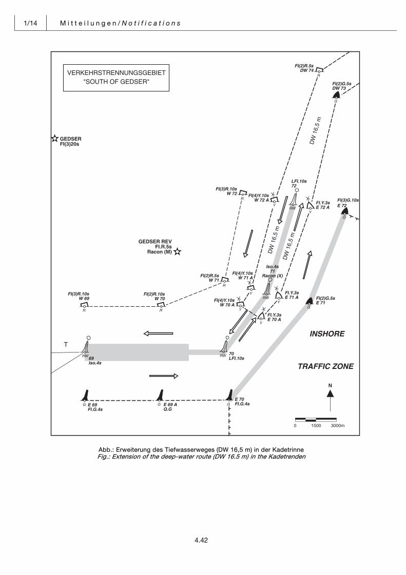
1/14 M i t t e i l u n g e n / N o t i f i c a t i o n s
4.42
Abb.: Erweiterung des Tiefwasserweges (DW 16,5 m) in der Kadetrinne Fig.: Extension of the deep-water route (DW 16.5 m) in the Kadetrenden
Pos: 38 /Module für alle Dokumente/Seitenumbruch @ 0\mod_1382702309853_0.docx @ 3729 @ @ 1
M i t t e i l u n g e n / N o t i f i c a t i o n s 1/14
4.43
Pos: 39 /NfS/Mitteilungen/jährliches Heft 1/35_Panama. Beachtung der Regeln für das Befahren des Panamakanals @ 0\mod_1382939676490_6.docx @ 3748 @ @ 1
Panama. Beachtung der Regeln für das Befah-ren des Panamakanals.
Panama. Compliance with the rules for transit-ing the Panama Canal.
(1/2013-Wiederholung) (1/2013-repetition)Am 31. Dezember 1999 ist der Panamakanal ver-tragsgemäß von den USA auf Panama übergegan-gen. Die Bundesrepublik Deutschland ist Vertrags-staat des Protokolls zu dem Vertrag über die dauernde Neutralität und den Betrieb des Panama-kanals vom 7. September 1977. Für die Bundesre-publik Deutschland ist das Protokoll am 9. Februar 1988 in Kraft getreten (BGBl. 1988 II S. 293). Danach sind Schiffe unter der Bundesflagge, die den Pana-makanal befahren, verpflichtet, die Regeln für das Befahren des Panamakanals strikt einzuhalten. Ge-mäß § 8a der Verordnung zur Sicherung der Seefahrt hat der Betreiber eines Schiffes unter Bundesflagge, das den Panamakanal befahren will, sicherzustellen, dass
On 31 December 1999, authority over the Panama Canal has been formally transferred from the United States of America to the Republic of Panama. The Federal Republic of Germany is a Contracting Party to the Protocol to the Treaty Concerning the Perma-nent Neutrality and Operation of the Panama Canal done on 7 September 1977. The Protocol has taken effect for the Federal Republic of Germany on 9 February 1988 (Federal Law Gazette 1988 II p. 293). Under its provisions, vessels flying the flag of the Federal Republic of Germany navigating through the Panama Canal are required to strictly observe the applicable rules. Under the provisions of Art. 8(a) of the Safety of Navigation Ordinance, the operator of a vessel flying the flag of the Federal Republic of Germany and intending to transit the Panama Canal shall ensure that
1. spätestens nach dem Einlaufen in den ersten Hafen des Kanals die Regeln für das Befahren des Panamakanals in der jeweils geltenden Fassung sich an Bord befinden und
1 the current version of the Panama Canal Autho-rity (PCA) Regulations is available on board not later than upon the vessel entering the first Canal port;
2. die für die Durchfahrt allgemein anerkannten Re-geln der Technik und der seemännischen Praxis eingehalten werden.
2 the universally recognized rules of technology and the principles of good seamanship are com-plied with during passage of the Canal.
Im Internet sind die Regeln abrufbar unter: www.pancanal.com
The above-mentioned PCA Regulations may be con-sulted by accessing the PCA Internet site under the following address: www.pancanal.com
Falls sich die jeweils geltende Fassung nicht an Bord befindet, wird sie auf Anforderung nach dem Einlau-fen in einen Endhafen des Kanals geliefert.
If the current version of the Regulations is not carried on board a given vessel as she enters the Canal, it will be supplied, upon request, to the port at the other end of the Canal for collection.
(BMVI WS23) 1/14 Pos: 40 /NfS/Mitteilungen/jährliches Heft 1/36_Kanada @ 0\mod_1383112121878_6.docx @ 3780 @ @ 1
Kanada. Teilnahme an Northern Canada Vessel Traffic Services (NORDREG) in den kanadi-schen Gewässern N-lich 60° N.
Canada. Participation in the Northern Canada Vessel Traffic Services (NORDREG) in Canadi-an waters north of 60° N.
(36/2010-Wiederholung) (36/2010-repetition)Kanada hat für seine arktischen Gewässer den ehe-mals freiwilligen Schiffsverkehrsdienst NORDREG ohne entsprechendes IMO-Mandat als verpflichtend erklärt. Diese Regelung ist nach Auffassung der Bundesregierung nicht mit internationalem Seerecht vereinbar.
Canada has declared its formerly voluntary Arctic Canada Traffic System (NORDREG) compulsory, outside IMO’s mandate. According to the German Federal Government, this provision is not in compli-ance with the international Law of the Sea.
Da bei Nichtteilnahme das Befahren der Gewässer seitens der kanadischen Behörden sanktioniert werden könnte, wird der deutschen Schifffahrt empfohlen, nur Meldungen mit dem Hinweis der freiwilligen Teilnahme abzugeben.
As access to these waters may be restricted by the Canadian authorities for vessels not participating in the system, German ships reporting information are recommended to state that their participation is voluntary.
(BMVI WS23, Az.: 62321.6/6-Nav-56) 1/14 Pos: 41 /NfS/Mitteilungen/jährliches Heft 1/38_Piraterie und bewaffnete Überfälle auf Schiffe @ 0\mod_1382941950303_6.docx @ 3754 @ @ 1
Piraterie und bewaffnete Überfälle auf Schiffe. Piracy and armed robbery against ship. (Siehe NfS-Heft 1/2013) (See NfS issue 1/2013)Wegen der seit 2008 extrem gestiegenen Zahl von Piratenüberfällen im Golf von Aden und vor der Küs-te Somalias hat der Schiffssicherheitsausschusses der Internationalen Seeschifffahrts-Organisation (IMO) das Zirkular „Beste Strategien und Verhal-tensweisen zum Schutz gegen somalische Piraterie“ (aktuelle Fassung: BMP 4, VkBl. 2013 S. 655, NfS-Heft 29/2013, www.deutsche-flagge.de) verabschie-det. Obwohl seit 2013 die Anzahl der Pirateriefälle
Due to extremely increasing cases of acts of piracy in the Gulf of Aden and off the coast of Somalia since 2008 the Maritime Safety Committee accepted a circular on piracy, called “The Best Management Practices for Protection against Somalia Based Pira-cy (latest version: BMP 4 (VkBl. 2013 S. 655, NfS is-sue 29/2013, www.deutsche-flagge.de). Although Somalia based piracy and armed robbery have dras-tically decreased in 2013, it is still strongly recom-
1/14 M i t t e i l u n g e n / N o t i f i c a t i o n s
4.44
und bewaffneten Raubüberfällen vor der Küste So-malias drastisch zurückgingen, wird weiterhin drin-gend empfohlen, schon vor jeder Fahrt, durch das immer noch gefährliche Seegebiet, die in diesem Zirkular vorgeschlagenen Vorsichtsmaßnahmen zu ergreifen, sofern sie auf das betreffende Schiff an-wendbar sind. Insbesondere sollte das Schiff bei den Streitkräften registriert werden, vor allem mit dem Maritime Security Centre – Horn of Africa (www.mschoa.eu oder [email protected]) und dem United Kingdom Maritime Trade Organisa-tion UKMTO Dubai. Weitere Beratungsstellen und Einzelheiten über den international empfohlenen Transitkorridor (IRTC) im Golf von Aden sind im IMO Dokument SN.1/Circ.281 vom 3. August 2009 zu finden.
mended to adopt all precautionary measures sug-gested in this circular as far as they are applicable to the individual ship even before the passage through the dangerous sea area. In particular every ship con-cerned should register with the military such as the Maritime Security Centre-Horn of Africa (www.mschoa.eu or [email protected]) and the United Kingdom Maritime Trade Organisation UKMTO Dubai. Additional points of contact and de-tails of an internationally recommended transit Corri-dor (IRTC) in the Gulf of Aden can be found in the IMO document SN.1/Circ.281, 3 August 2009.
Ebenso wie für den Golf von Aden und das Seege-biet vor Somalia ist auch der Golf von Guinea mit Gefahrenstufe 2 eingestuft. Die IMO veröffentlichte hierfür einen Vorläufigen Leitfaden für Reeder, Schiffsbetreiber und Schiffsführer zum Schutz gegen Piraterie in der Region (Circular letter No. 3394, 15. August 2013).
Alike the Gulf of Aden and the sea area off the coast of Somalia the threat level 2 is also applied to the region of the Gulf of Guinea. Therefore IMO pub-lished Interim Guidelines for Owners, Operators and Masters for protection against piracy in the Gulf of Guinea region (Circular letter No. 3394, 15 August 2013).
Neuerung: Mit Änderung der See-Eigensicherungs-verordnung (BGBl. 2013 Teil I S. 2812, NfS-Heft 35/2013) ist es zwingend erforderlich, dass die Reeder die Verpflichtung zur Nutzung international eingerichteter Melde- und Warnsysteme beim Ein-fahren in oder durch ein Seegebiet der Gefahrenstu-fe 2 oder 3 in den Gefahrenabwehrplan ihrer Schiffe aufnehmen. Darüber hinaus erhalten die Reeder die Option, private bewaffnete Wachpersonen (PCASP) einzusetzen, sofern das Bewachungsunternehmen vom Bundesamt für Wirtschaft und Ausfuhrkontrolle (BAFA) zugelassenen ist. Darüber hinaus ist ein ent-sprechender vom Bundesamt für Seeschifffahrt und Hydrographie (BSH) auf Antrag des Reeders ge-nehmigter Zusatz zum Gefahrenabwehrplan des Schiffs erforderlich, der die Verwendung von PCASP zulässt. Der Zusatz zum Gefahrenabwehrplan auf dem Schiff gilt für einen Zeitraum von längstens zwei Jahren. Die Genehmigung wird unter der Bedingung erteilt, dass der Gefahrenbeauftragte des Unterneh-mens spätestens 24 Stunden vor Einfahrt in ein, in die Gefahrenstufe 2 oder 3 eingestuftes Seegebiet der Zentralen Kontaktstelle POC den Einsatz von PCASP an Bord anzeigt.
Change of legislation: according to a change of the Ordinance on Shipboard Security Measures (See-Eigensicherungsverordnung) (BGBl. 2013 Part I p. 2812, NfS issue 35/2013) it is required that opera-tors include in the ship security plan the obligation to use the international reporting and warning systems before their ships enter a sea area, where threat level 2 or 3 is applied. Moreover operators have the option to use privately contracted armed security personnel (PCASP) on board of their ships, provided the private maritime security company has been certified by the German BAFA (Bundesamt für Wirtschaft und Ausfuhrkontrolle) and the Federal Maritime and Hy-drographic Agency (BSH) has approved an applica-tion of the operator for an addendum to the ship se-curity plan allowing the use of PCASP. The addendum is valid for two years. The added license will only be granted under the condition, that 24 hours before the ship enters a sea-area of threat-level 2 or 3 the Company Security Officer (CSO) re-ports to the Point of Contact (POC) that PCASP is on board.
Der Schiffssicherheitsausschuss der IMO hat sowohl Empfehlungen für Mitgliedstaaten als auch Leitlinien für solche Schiffe verabschiedet, die private bewaff-nete Sicherheitsteams an Bord nehmen:
The Maritime Safety Committee of the International Maritime Organisation (IMO) adopted both recom-mendations for member states and guidance to those ships using privately contracted armed securi-ty personnel on board.
– Überarbeitete vorläufige Leitlinien für Reeder, Schiffsbetreiber und Schiffsführer über den Ein-satz von bewaffnetem privaten Wachpersonal an Bord von Schiffen in dem Hochrisikogebiet (MSC.1/Circ.1405/Rev.2, VkBl. 2013 S. 640, NfS-Heft 29/2013, www.deutsche-flagge.de),
– Interim guidance to shipowners, ship operators and shipmasters on the use of privately contract-ed armed security personnel on board ships in the High Risk Area (MSC.1/Circ.1405/Rev.2, VkBl. 2013 p. 640, NfS issue 29/2013, www.deutsche-flagge.de),
– Vorläufige Leitlinien für private Bewachungsun-ternehmen zur Gefahrenabwehr in der Schiff-fahrt, die privates bewaffnetes Wachpersonal an Bord von Schiffen im Hochrisikogebiet bereit-stellen (MSC.1/Circ.1443, VkBl. 2013 S. 676, NfS-Heft 29/2013) ,
– Guidance to private maritime security companies providing privately contracted armed security personnel on board ships in the High Risk Area (MSC.1/Circ.1443, VkBl. 2013 p. 676, NfS issue 29/2013 ),
– Überarbeitete vorläufige Empfehlungen für Flag-
genstaaten zum Einsatz von bewaffnetem priva-ten Wachpersonal an Bord von Schiffen im Hochrisikogebiet (MSC.1/Circ.1406/Rev.2),
– Interim recommendations for flag states regard-ing the use of privately contracted armed secu-rity personnel on board ships in the high risk area (MSC.1/Circ.1406/Rev.2),
M i t t e i l u n g e n / N o t i f i c a t i o n s 1/14
4.45
– Vorläufige Empfehlungen für Hafen- und Küsten-staaten zum Einsatz von privatem bewaffneten Wachpersonal an Bord von Schiffen im Hochrisi-kogebiet (MSC.1/Circ.1408, VkBl. 2013 S. 672, NfS-Heft 29/2013),
– Interim recommendations for port and coastal states regarding the use of privately contracted armed security personnel on board ships in the high risk area (MSC.1/Circ.1408, VkBl. 2013 p. 672, NfS issue 29/2013).
– Vorläufige Leitlinien für Flaggenstaaten über Maßnahmen zur Verhütung und Eindämmung der Piraterie vor der Küste Somalias (MSC.1/Circ.1444, VkBl. 2013 S. 651, NfS-Heft 29/2013).
– Interim guidance for flag States an measures to prevent and mitigate Somalia-based piracy (MSC.1/Circ.1444, Vkbl. 2013 p. 651, NfS issue 29/2013).
(BMVI WS 22) 1/14 Pos: 42 /NfS/Mitteilungen/jährliches Heft 1/39_IMB Piracy Reporting Centre @ 0\mod_1382943294317_6.docx @ 3757 @ @ 1
IMB Piracy Reporting Centre. IMB Piracy Reporting Centre. (1/2013-Wiederholung) (1/2013-repetition)Das am 1. Oktober 1992 in Kuala Lumpur eingerich-tete IMB Piracy Reporting Centre des International Maritime Bureau (IMB) nimmt rund um die Uhr Mel-dungen über tatsächliche und versuchte Piratenan-griffe und bewaffnete Raubüberfälle auf Seeschiffe entgegen. Die das Büro erreichenden Informationen werden über das INMARSAT-C-System und NAV-TEX an die Schifffahrt weiter gegeben. Außerdem können Informationen über das Internet oder per Telefon abgerufen werden.
The IMB Piracy Reporting Centre created in Kuala Lumpur on 1 October 1992 maintains a round-the-clock-watch and is a point of contact for the ship-master to report an actual or attempted piratical at-tack or armed robbery. The Centre disseminates the incoming information to the shipping community via INMARSAT-C-System and through NAVTEX. In addition, vessels may obtain information via Internet or by telephone.
Das Zentrum wird aus freiwilligen Beiträgen der Schifffahrtsindustrie finanziert. Die Dienste selbst sind kostenlos.
The Piracy Reporting Centre is financed by voluntary contributions from the shipping industry and pro-vides its services free of charge.
Wenn Sie einen Hinweis auf einen Vorfall mit Beteili-gung von Piraten geben oder einen bewaffneten Raubüberfall melden wollen, wenden Sie sich bitte an folgende Adresse:
If you wish to report an piratical incident or armed robbery please contact the Centre through the fol-lowing channels:
Schiffe, die den Safety NET-Dienst von INMARSAT-C benutzen, können täglich vom Zentrum über die Küsten-Erdfunkstelle Singapore und über die Satelli-ten für die Gebiete des Pazifiks und des Indischen Ozeans verbreitete Warnmeldungen empfangen.
Vessels using the SafetyNET Service offered by IN-MARSAT-C have the option of receiving the daily status bulletins broadcast by the Centre via the Coast Radio Station Singapore and the satellites covering the Pacific and Indian Ocean regions.
Auf der IMB Webseite ist auch eine Live Piracy Map eingerichtet. Darüber hinaus werden genaue Infor-mationen zu Art und Ort von Überfällen gegeben.
The IMB Website also provides a Live Piracy Map. Moreover accurate information on nature and loca-tion of attacks are also available.
Warnhinweis: Für Fahrten durch den Golf von Aden und entlang der Küste Somalias bis zu den Seychellen gilt die Gefahrenstufe 2. Schiffe, die dieses Gebiet passie-ren, wird zu ihrer eigenen Sicherheit dringend emp-fohlen wegen der hohen Gefahr eines Piratenangriffs sich bei folgender E-Mail-Adresse zu registrieren: www.mschoa.org.
Warning:Vessels sailing through the Gulf of Aden or off the coast of Somalia up to the Seychelles have to ob-serve security level 2 (two). For the sake of the ship’s security it is strongly recommended to register ship and passage plan prior to transit of the high risk area with www.mschoa.org.
(BMVI WS22) 1/14 Pos: 43 /Module für alle Dokumente/Seitenumbruch @ 0\mod_1382702309853_0.docx @ 3729 @ @ 1
ICC-INTERNATIONAL MARITIME BUREAU Telefon/Phone: +6 03 20 78 57 63 Telefax/Fax: +6 03 20 78 57 69 Telex: MA 31 199 IMBPCI E-Mail: [email protected] [email protected] 24 Hours Anti Piracy Helpline Telefon/Phone: +6 03 20 31 00 14
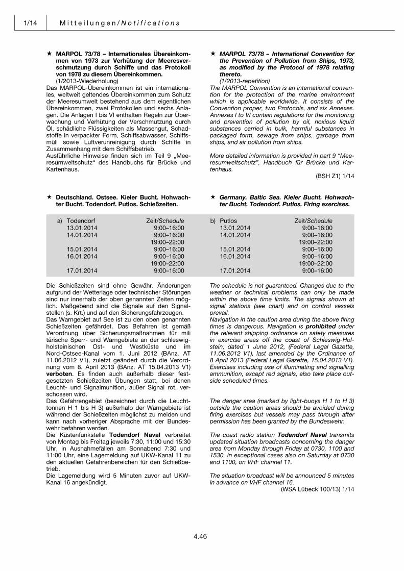
1/14 M i t t e i l u n g e n / N o t i f i c a t i o n s
4.46
Pos: 44 /NfS/Mitteilungen/jährliches Heft 1/40_MARPOL 73/78 @ 0\mod_1382947188582_6.docx @ 3760 @ @ 1
MARPOL 73/78 – Internationales Übereinkom-men von 1973 zur Verhütung der Meeresver-schmutzung durch Schiffe und das Protokoll von 1978 zu diesem Übereinkommen.
MARPOL 73/78 – International Convention for the Prevention of Pollution from Ships, 1973, as modified by the Protocol of 1978 relating thereto.
(1/2013-Wiederholung) (1/2013-repetition)Das MARPOL-Übereinkommen ist ein internationa-les, weltweit geltendes Übereinkommen zum Schutz der Meeresumwelt bestehend aus dem eigentlichen Übereinkommen, zwei Protokollen und sechs Anla-gen. Die Anlagen I bis VI enthalten Regeln zur Über-wachung und Verhütung der Verschmutzung durch Öl, schädliche Flüssigkeiten als Massengut, Schad-stoffe in verpackter Form, Schiffsabwasser, Schiffs-müll sowie Luftverunreinigung durch Schiffe in Zusammenhang mit dem Schiffsbetrieb.
The MARPOL Convention is an international conven-tion for the protection of the marine environment which is applicable worldwide. It consists of the Convention proper, two Protocols, and six Annexes. Annexes I to VI contain regulations for the monitoring and prevention of pollution by oil, noxious liquid substances carried in bulk, harmful substances in packaged form, sewage from ships, garbage from ships, and air pollution from ships.
Ausführliche Hinweise finden sich im Teil 9 „Mee-resumweltschutz“ des Handbuchs für Brücke und Kartenhaus.
More detailed information is provided in part 9 “Mee-resumweltschutz”, Handbuch für Brücke und Kar-tenhaus.
(BSH Z1) 1/14 Pos: 45 /NfS/Mitteilungen/NfS-Woche/2014/NfS 01/2014/41_Schießzeiten @ 0\mod_1387179799432_6.docx @ 4098 @ @ 1
Deutschland. Ostsee. Kieler Bucht. Hohwach-ter Bucht. Todendorf. Putlos. Schießzeiten.
Germany. Baltic Sea. Kieler Bucht. Hohwach-ter Bucht. Todendorf. Putlos. Firing exercises.
Die Schießzeiten sind ohne Gewähr. Änderungen aufgrund der Wetterlage oder technischer Störungen sind nur innerhalb der oben genannten Zeiten mög-lich. Maßgebend sind die Signale auf den Signal-stellen (s. Krt.) und auf den Sicherungsfahrzeugen.
The schedule is not guaranteed. Changes due to the weather or technical problems can only be made within the above time limits. The signals shown at signal stations (see chart) and on control vessels prevail.
Das Warngebiet auf See ist zu den oben genannten Schießzeiten gefährdet. Das Befahren ist gemäß Verordnung über Sicherungsmaßnahmen für militärische Sperr- und Warngebiete an der schleswig-holsteinischen Ost- und Westküste und im Nord-Ostsee-Kanal vom 1. Juni 2012 (BAnz. AT 11.06.2012 V1), zuletzt geändert durch die Verord-nung vom 8. April 2013 (BAnz. AT 15.04.2013 V1) verboten. Es finden auch außerhalb dieser fest-gesetzten Schießzeiten Übungen statt, bei denen Leucht- und Signalmunition, außer Signal rot, ver-schossen wird.
Navigation in the caution area during the above firing times is dangerous. Navigation is prohibited under the relevant shipping ordinance on safety measures in exercise areas off the coast of Schleswig-Hol-stein, dated 1 June 2012, (Federal Legal Gazette, 11.06.2012 V1), last amended by the Ordinance of 8 April 2013 (Federal Legal Gazette, 15.04.2013 V1). Exercises including use of illuminating and signalling ammunition, except red signals, also take place out-side scheduled times.
Das Gefahrengebiet (bezeichnet durch die Leucht-tonnen H 1 bis H 3) außerhalb der Warngebiete ist während der Schießzeiten möglichst zu meiden und kann nach vorheriger Absprache mit der Bundes-wehr befahren werden.
The danger area (marked by light-buoys H 1 to H 3) outside the caution areas should be avoided during firing exercises but vessels may pass through after permission has been granted by the Bundeswehr.
Die Küstenfunkstelle Todendorf Naval verbreitet von Montag bis Freitag jeweils 7:30, 11:00 und 15:30 Uhr, in Ausnahmefällen am Sonnabend 7:30 und 11:00 Uhr, eine Lagemeldung auf UKW-Kanal 11 zu den aktuellen Gefahrenbereichen für den Schießbe-trieb.
The coast radio station Todendorf Naval transmits updated situation broadcasts concerning the danger area from Monday through Friday at 0730, 1100 and 1530, in exceptional cases also on Saturday at 0730 and 1100, on VHF channel 11.
Die Lagemeldung wird 5 Minuten zuvor auf UKW-Kanal 16 angekündigt.
The situation broadcast will be announced 5 minutes in advance on VHF channel 16.
(WSA Lübeck 100/13) 1/14 Pos: 46 /Module für alle Dokumente/Seitenumbruch @ 0\mod_1382702309853_0.docx @ 3729 @ @ 1
a) Todendorf Zeit/Schedule b) Putlos Zeit/Schedule 13.01.2014 9:00–16:00 13.01.2014 9:00–16:00 14.01.2014 9:00–16:00 14.01.2014 9:00–16:00 19:00–22:00 19:00–22:00 15.01.2014 9:00–16:00 15.01.2014 9:00–16:00 16.01.2014 9:00–16:00 16.01.2014 9:00–16:00 19:00–22:00 19:00–22:00 17.01.2014 9:00–16:00 17.01.2014 9:00–16:00
M i t t e i l u n g e n / N o t i f i c a t i o n s 1/14
4.47
Pos: 47 /NfS/Mitteilungen/NfS-Woche/2014/NfS 01/2014/42_Messgeräte Ostsee @ 0\mod_1387181172830_6.docx @ 4101 @ @ 1
Deutschland. Ostsee. Zeitweilige Messgeräte. Germany. Baltic Sea. Temporary measuring instruments.
(Mitteilung im NfS-Heft 49/2013 aufgehoben) (Notification in NfS issue 49/2013 cancelled)Zahlreiche Messgeräte liegen zeitweilig in den Küstengewässern und der Ausschließlichen Wirt-schaftszone Deutschlands in der Ostsee aus.
Numerous measuring instruments are established temporarily in the German coastal waters and Exclu-sive Economic Zone in the Baltic Sea.
Die Tabelle weist auf die diesbezüglichen, gültigen Bekanntmachungen für Seefahrer (BfS) der zustän-digen Wasser- und Schifffahrtsämter (WSÄ) hin. Die Bekanntmachungen enthalten weitere Angaben zu Anzahl der Messstellen, der genauen geographi-schen Lage, den betroffenen Karten, der voraus-sichtlichen Dauer und besondere Bemerkungen.
The table below lists currently valid notifications (BfS) of the Waterways and Shipping Boards (WSA). The notifications contain additional details concern-ing the number of measuring points, their geograph-ic position, charts affected, expected duration, and special notes.
Die Tabelle ist auf folgender BSH-Webseite online: The table is available online on the BSH’s following internet page:
http://www.bsh.de/de/Schifffahrt/Berufsschifffahrt/Nautische_Warnnachrichten/index.jsp
http://www.bsh.de/en/Maritime_shipping/Commer-cial_shipping/Navigational_warnings/index.jsp
WSA mit BfS-Nummer WSA with BfS No.
Datum Date
SeegebietSea area
Karten Charts
BemerkungenRemarks
WSA Stralsund 186(T)/13 17.12.2013 Kadetrinne, Kriegers Flak 162, 163 WSA Stralsund 173(T)/12 verlän-gert/ prolonged
WSA Stralsund 158(T)/13 24.10.2013 Adlergrund, Oderbank 151, 163
WSA Stralsund 64(T)/13 31.05.2013 S-lich Kadetrinne 1671
WSA Stralsund 63(T)/13 31.05.2013 NO-lich Plantagenetgrund 162 WSA Stralsund 57(T)/12 verlän-gert/ prolonged
WSA Stralsund 58(T)/13 29.05.2013 Plantagenetgrund, Arkona, Pommersche Bucht
1511, 162
WSA Lübeck 10(T)/13 31.01.2013 Kieler Bucht 43
WSA Stralsund 183(T)/12 10.12.2012 W-lich Plantagenetgrund 162
WSA Stralsund 180(T)/12 04.12.2012 Adlergrund, Oderbank 151, 162, 1511, 1512
WSA Stralsund 168(T)/12 12.11.2012 Mecklenburger Bucht 1671
WSA Stralsund 114(T)/12 15.08.2012 W-lich Adlergrund 40
WSA Stralsund 106(T)/12 03.08.2012 Mecklenburger und Pommer-sche Bucht
1671, 1511
WSA Lübeck 93(T)/11 24.10.2011 Fehmarnbelt, Kieler Bucht und Mecklenburger Bucht
31, 43
WSA Lübeck 102(T)/13 aufgehoben/cancelled
WSA Stralsund 173(T)/12 aufgehoben/cancelled
Die Messgeräte sind mit gelben Tonnen oder Leuchttonnen bezeichnet und in sicherem Abstand (mindestens 2 Kabel) zu passieren. Die Karte mit dem besten Maßstab ist berücksichtigt.
The measuring instruments are marked either by yellow buoys or by yellow light-buoys and have to be passed at a safe distance (at least 2 cables). The most convenient chart is quoted.
Weitere Angaben zu Messgeräten siehe IHO Circular Letter 30/2000 und Handbuch für Brücke und Kar-tenhaus.
For additional information about the measuring instruments, please refer to IHO Circular Letter 30/2000 and Handbuch für Brücke und Kartenhaus. (WSA Lübeck 105/13; WSA Stralsund 186(T)/13) 1/14
Pos: 48 /Module für alle Dokumente/Seitenumbruch @ 0\mod_1382702309853_0.docx @ 3729 @ @ 1
1/14 M i t t e i l u n g e n / N o t i f i c a t i o n s
4.48
Pos: 49 /NfS/Mitteilungen/NfS-Woche/2014/NfS 01/2014/43_Seebücher @ 0\mod_1387288802937_6.docx @ 4108 @ @ 1
Nautischer Informationsdienst. Seebücher. Navigational Information Service. Nautical Books.
(Siehe Mitteilung im NfS-Heft 40/2013) (See Notification in NfS issue 40/2013) Im Jahr 2013 erschienen folgende Neuauflagen von Seebüchern:
Following new editions of nautical books were pub-lished in 2013:
B e a b s i c h t i g t e Neuauflagen von Seebüchern: New editions of nautical books scheduled for publi-
cation:
(BSH N2) 1/14 === Ende der Liste für Textmarke Inhalt ===
20005 Seeschifffahrtsstraßen-Ordnung mit den Bekanntmachungen der Generaldirektion Wasserstra-ßen und Schifffahrt, Außenstellen Nordwest und Nord
2002 Ostsee-Handbuch, westlicher Teil 20031 Ostsee-Handbuch, südwestlicher Teil 20034 Sailing Directions, Baltic Sea, Southwestern Part 2009 Handbuch Dänemark und Westküste Schweden 2010 Winterbetonnung 2013/2014 2115 Gezeitentafeln, Europäische Gewässer 2014 2155 Funkdienst für die Klein- und Sportschifffahrt 2013 2175 Nautisches Jahrbuch, Ephemeriden und Tafeln 2014 2452 Katalog Seekarten und Bücher 2014 3001 Wegepunkte in der Nord- und Ostsee 2013 4002 Leuchtfeuerverzeichnis Teil 2, westliche Ostsee und Ostseezufahrten 5000 Handbuch Nautischer Funkdienst 5001 Handbuch Revierfunkdienst
20001 Handbuch für Brücke und Kartenhaus20061 Nordsee-Handbuch, südöstlicher Teil 20064 Sailing Directions North Sea, Southeastern Part 2155 Funkdienst für die Klein- und Sportschifffahrt 2014 3001 Wegepunkte in der Nord- und Ostsee 2014 40011 Leuchtfeuerverzeichnis Teil 1, Band 1, Mittlere und östliche Ostsee 40012 Leuchtfeuerverzeichnis Teil 1, Band 2, Nördliche Ostsee
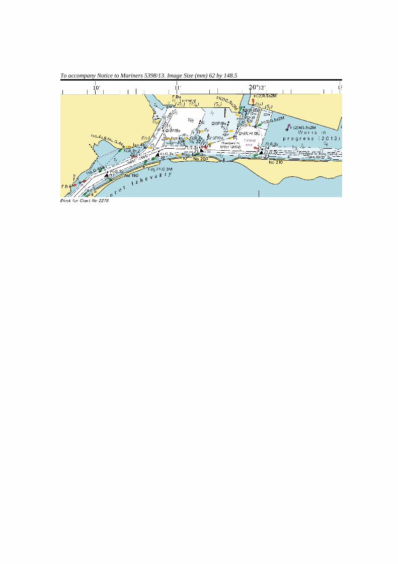
To accompany Notice to Mariners 5398/13. Image Size (mm) 62 by 148.5
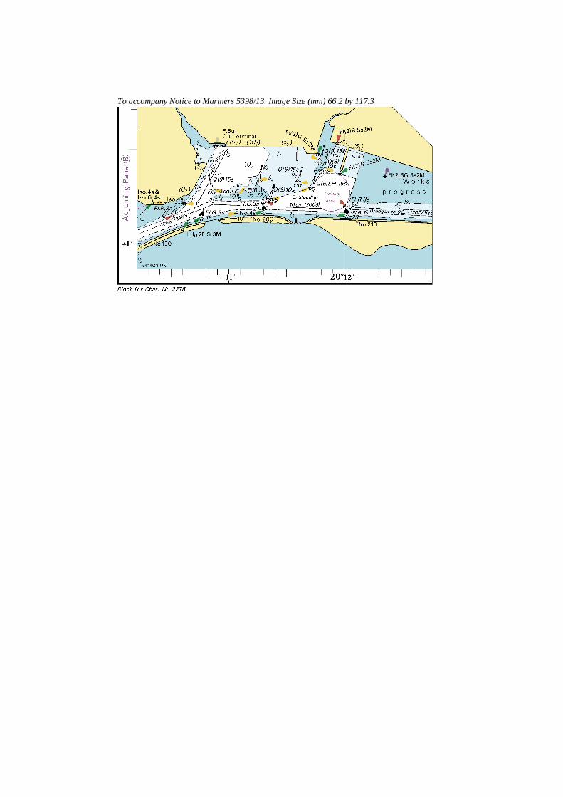
To accompany Notice to Mariners 5398/13. Image Size (mm) 66.2 by 117.3
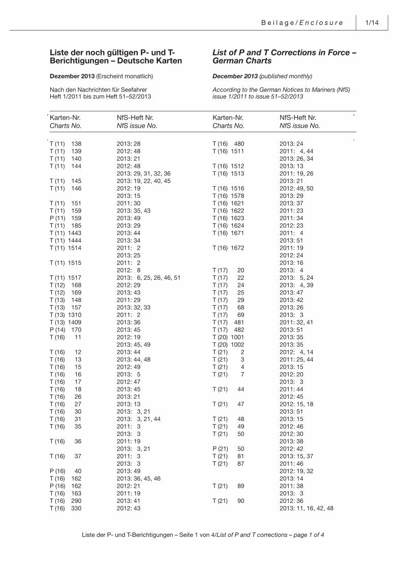
Liste der P- und T-Berichtigungen – Seite 1 von 4/List of P and T corrections – page 1 of 4
B e i l a g e / E n c l o s u r e 1/14
T (11) 138 2013: 28T (11) 139 2012: 48T (11) 140 2013: 21T (11) 144 2012: 48 2013: 29, 31, 32, 36T (11) 145 2013: 19, 22, 40, 45T (11) 146 2012: 19 2013: 15T (11) 151 2011: 30T (11) 159 2013: 35, 43P (11) 159 2013: 49T (11) 185 2013: 29T (11) 1443 2013: 44T (11) 1444 2013: 34T (11) 1514 2011: 2 2013: 25T (11) 1515 2011: 2 2012: 8T (11) 1517 2013: 6, 25, 26, 46, 51T (12) 168 2012: 29T (12) 169 2013: 43T (13) 148 2011: 29T (13) 157 2013: 32, 33T (13) 1310 2011: 2T (13) 1409 2013: 36P (14) 170 2013: 45T (16) 11 2012: 19 2013: 45, 49T (16) 12 2013: 44T (16) 13 2013: 44, 48T (16) 15 2012: 49T (16) 16 2013: 5T (16) 17 2012: 47T (16) 18 2013: 45T (16) 26 2013: 21T (16) 27 2013: 13T (16) 30 2013: 3, 21T (16) 31 2013: 3, 21, 44T (16) 35 2011: 3 2013: 3T (16) 36 2011: 19 2013: 3, 21T (16) 37 2011: 3 2013: 3P (16) 40 2013: 49T (16) 162 2013: 36, 45, 46P (16) 162 2012: 21T (16) 163 2011: 19T (16) 290 2013: 41T (16) 330 2012: 43
T (16) 480 2013: 24T (16) 1511 2011: 4, 44 2013: 26, 34T (16) 1512 2013: 13T (16) 1513 2011: 19, 26 2013: 21T (16) 1516 2012: 49, 50T (16) 1578 2013: 29T (16) 1621 2013: 37T (16) 1622 2011: 23T (16) 1623 2011: 34T (16) 1624 2012: 23T (16) 1671 2011: 4 2013: 51T (16) 1672 2011: 19 2012: 24 2013: 16T (17) 20 2013: 4T (17) 22 2013: 5, 24T (17) 24 2013: 4, 39T (17) 25 2013: 47T (17) 29 2013: 42T (17) 68 2013: 26T (17) 69 2013: 3T (17) 481 2011: 32, 41T (17) 482 2013: 51T (20) 1001 2013: 35T (20) 1002 2013: 35T (21) 2 2012: 4, 14T (21) 3 2011: 25, 44T (21) 4 2013: 15T (21) 7 2012: 20 2013: 3T (21) 44 2011: 44 2012: 45T (21) 47 2012: 15, 18 2013: 51T (21) 48 2013: 15T (21) 49 2012: 46T (21) 50 2012: 30 2013: 38P (21) 50 2012: 42T (21) 81 2013: 15, 37T (21) 87 2011: 46 2012: 19, 32 2013: 14T (21) 89 2011: 38 2013: 3T (21) 90 2012: 36 2013: 11, 16, 42, 48
Liste der noch gültigen P- und T-Berichtigungen – Deutsche Karten
Dezember 2013 (Erscheint monatlich)
Nach den Nachrichten für SeefahrerHeft 1/2011 bis zum Heft 51–52/2013
List of P and T Corrections in Force – German Charts
December 2013 (published monthly)
According to the German Notices to Mariners (NfS)issue 1/2011 to issue 51–52/2013
Karten-Nr.Charts No.
NfS-Heft Nr.NfS issue No.
Karten-Nr.Charts No.
NfS-Heft Nr.NfS issue No.
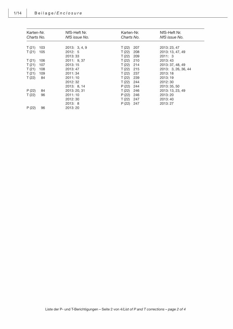
Liste der P- und T-Berichtigungen – Seite 2 von 4/List of P and T corrections – page 2 of 4
1/14 B e i l a g e / E n c l o s u r e
T (21) 103 2013: 3, 4, 9T (21) 105 2012: 5 2013: 33T (21) 106 2011: 9, 37T (21) 107 2013: 15T (21) 108 2013: 47T (21) 109 2011: 34T (22) 84 2011: 10 2012: 32 2013: 8, 14P (22) 84 2013: 20, 31T (22) 96 2011: 10 2012: 30 2013: 8P (22) 96 2013: 20
T (22) 207 2013: 23, 47T (22) 208 2013: 13, 47, 49T (22) 209 2011: 3T (22) 210 2013: 43T (22) 214 2013: 37, 48, 49T (22) 215 2013: 3, 26, 36, 44T (22) 237 2013: 18T (22) 239 2013: 19T (22) 244 2012: 30P (22) 244 2013: 35, 50T (22) 246 2013: 13, 23, 49P (22) 246 2013: 20T (22) 247 2013: 40P (22) 247 2013: 27
Karten-Nr.Charts No.
NfS-Heft Nr.NfS issue No.
Karten-Nr.Charts No.
NfS-Heft Nr.NfS issue No.
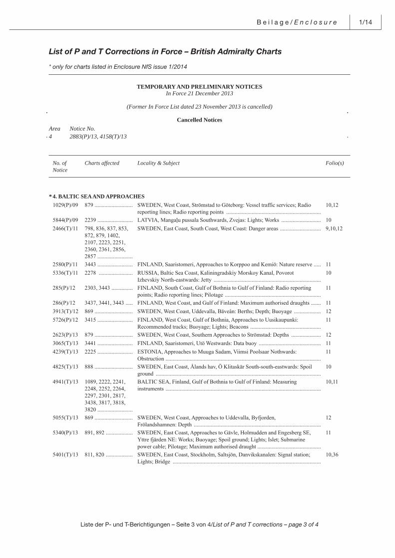
Liste der P- und T-Berichtigungen – Seite 3 von 4/List of P and T corrections – page 3 of 4
B e i l a g e / E n c l o s u r e 1/14
List of P and T Corrections in Force – British Admiralty Charts
* only for charts listed in Enclosure NfS issue 1/2014
TEMPORARY AND PRELIMINARY NOTICESIn Force 21 December 2013
(Former In Force List dated 23 November 2013 is cancelled)
Cancelled NoticesArea Notice No.4 2883(P)/13, 4158(T)/13
No. ofNotice
Charts affected Locality & Subject Folio(s)
* 4. BALTIC SEA AND APPROACHES 1029(P)/09 879 ........................... SWEDEN, West Coast, Strömstad to Göteborg: Vessel traffic services; Radio
reporting lines; Radio reporting points ...................................................................10,12
5844(P)/09 2239 ......................... LATVIA, Mangaļu pussala Southwards, Zvejas: Lights; Works ............................ 102466(T)/11 798, 836, 837, 853,
872, 879, 1402,2107, 2223, 2251, 2360, 2361, 2856, 2857 .........................
SWEDEN, East Coast, South Coast, West Coast: Danger areas ............................. 9,10,12
2580(P)/11 3443 ......................... FINLAND, Saaristomeri, Approaches to Korppoo and Kemiö: Nature reserve ..... 115336(T)/11 2278 ........................ RUSSIA, Baltic Sea Coast, Kaliningradskiy Morskoy Kanal, Povorot
Izhevskiy North-eastwards: Jetty ............................................................................10
285(P)/12 2303, 3443 ............... FINLAND, South Coast, Gulf of Bothnia to Gulf of Finland: Radio reporting points; Radio reporting lines; Pilotage ....................................................................
11
286(P)/12 3437, 3441, 3443 ..... FINLAND, West Coast, and Gulf of Finland: Maximum authorised draughts ....... 113913(T)/12 869 ........................... SWEDEN, West Coast, Uddevalla, Bäveån: Berths; Depth; Buoyage ................... 125726(P)/12 3415 ......................... FINLAND, West Coast, Gulf of Bothnia, Approaches to Uusikaupunki:
Recommended tracks; Buoyage; Lights; Beacons ..................................................11
2623(P)/13 879 ........................... SWEDEN, West Coast, Southern Approaches to Strömstad: Depths ..................... 123065(T)/13 3441 ......................... FINLAND, Saaristomeri, Utö Westwards: Data buoy ............................................ 114239(T)/13 2225 ......................... ESTONIA, Approaches to Muuga Sadam, Viimsi Poolsaar Nothwards:
Obstruction ..............................................................................................................11
4825(T)/13 888 ........................... SWEDEN, East Coast, Ålands hav, Ö Klitaskär South-south-eastwards: Spoilground .....................................................................................................................
10
4941(T)/13 1089, 2222, 2241,2248, 2252, 2264,2297, 2301, 2817,3438, 3817, 3818,3820 .........................
BALTIC SEA, Finland, Gulf of Bothnia to Gulf of Finland: Measuringinstruments ..............................................................................................................
10,11
5055(T)/13 869 ........................... SWEDEN, West Coast, Approaches to Uddevalla, Byfjorden,Frölandshamnen: Depth ..........................................................................................
12
5340(P)/13 891, 892 ................... SWEDEN, East Coast, Approaches to Gävle, Holmudden and Engesberg SE, Yttre fjärden NE: Works; Buoyage; Spoil ground; Lights; Islet; Submarine power cable; Pilotage; Maximum authorised draught .............................................
11
5401(T)/13 811, 820 ................... SWEDEN, East Coast, Stockholm, Saltsjön, Danvikskanalen: Signal station; Lights; Bridge .........................................................................................................
10,36
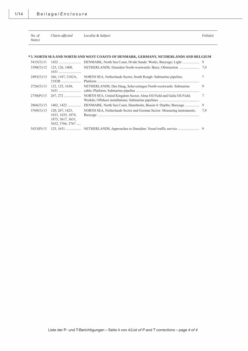
Liste der P- und T-Berichtigungen – Seite 4 von 4/List of P and T corrections – page 4 of 4
1/14 B e i l a g e / E n c l o s u r e
No. ofNotice
Charts affected Locality & Subject Folio(s)
* 5. NORTH SEA AND NORTH AND WEST COASTS OF DENMARK, GERMANY, NETHERLANDS AND BELGIUM 5415(T)/11 1422 ......................... DENMARK, North Sea Coast, Hvide Sande: Works; Buoyage; Light ................... 93390(T)/12 125, 126, 1408,
1631 .........................NETHERLANDS, IJmuiden North-westwards: Buoy; Obstruction ...................... 7,9
2493(T)/13 266, 1187, 2182A, 2182B ......................
NORTH SEA, Netherlands Sector, South Rough: Submarine pipeline;Platform ...................................................................................................................
7
2726(T)/13 122, 125, 1630,1631 .........................
NETHERLANDS, Den Haag, Scheveningen North-westwards: Submarinecable; Platform; Submarine pipeline .......................................................................
9
2750(P)/13 267, 272 ................... NORTH SEA, United Kingdom Sector, Alma Oil Field and Galia Oil Field;Workds; Offshore installations; Submarine pipelines .............................................
7
2866(T)/13 1402, 1422 ............... DENMARK, North Sea Coast, Hanstholm, Bassin 4: Depths; Buoyage ................ 93769(T)/13 120, 267, 1423,
1633, 1635, 1874, 1875, 3617, 3631, 3632, 3766, 3767 .....
NORTH SEA, Netherlands Sector and German Sector: Measuring instruments; Buoyage ..................................................................................................................
7,9
5433(P)/13 125, 1631 ................. NETHERLANDS, Approaches to IJmuiden: Vessel traffic service ........................ 9
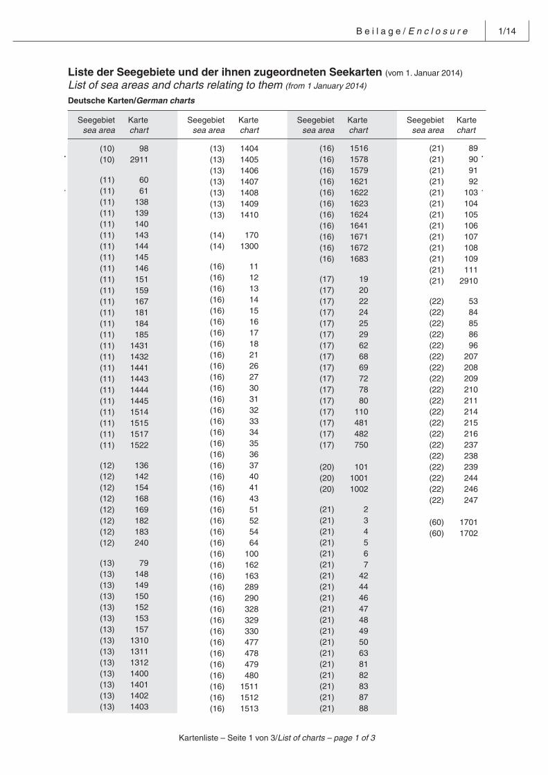
B e i l a g e / E n c l o s u r e 1/14
Liste der Seegebiete und der ihnen zugeordneten Seekarten (vom 1. Januar 2014)
List of sea areas and charts relating to them (from 1 January 2014) Deutsche Karten/German charts
Seegebietsea area
Kartechart
Seegebietsea area
Kartechart
Seegebietsea area
Kartechart
Seegebietsea area
Kartechart
Kartenliste – Seite 1 von 3/List of charts – page 1 of 3
(13) 1404 (13) 1405 (13) 1406 (13) 1407 (13) 1408 (13) 1409 (13) 1410
(14) 170 (14) 1300
(16) 11 (16) 12 (16) 13 (16) 14 (16) 15 (16) 16 (16) 17 (16) 18 (16) 21 (16) 26 (16) 27 (16) 30 (16) 31 (16) 32 (16) 33 (16) 34 (16) 35 (16) 36 (16) 37 (16) 40 (16) 41 (16) 43 (16) 51 (16) 52 (16) 54 (16) 64 (16) 100 (16) 162 (16) 163 (16) 289 (16) 290 (16) 328 (16) 329 (16) 330 (16) 477 (16) 478 (16) 479 (16) 480 (16) 1511 (16) 1512 (16) 1513
(16) 1516 (16) 1578 (16) 1579 (16) 1621 (16) 1622 (16) 1623 (16) 1624 (16) 1641 (16) 1671 (16) 1672 (16) 1683
(17) 19 (17) 20 (17) 22 (17) 24 (17) 25 (17) 29 (17) 62 (17) 68 (17) 69 (17) 72 (17) 78 (17) 80 (17) 110 (17) 481 (17) 482 (17) 750 (20) 101 (20) 1001 (20) 1002
(21) 2 (21) 3 (21) 4 (21) 5 (21) 6 (21) 7 (21) 42 (21) 44 (21) 46 (21) 47 (21) 48 (21) 49 (21) 50 (21) 63 (21) 81 (21) 82 (21) 83 (21) 87 (21) 88
(21) 89 (21) 90 (21) 91 (21) 92 (21) 103 (21) 104 (21) 105 (21) 106 (21) 107 (21) 108 (21) 109 (21) 111 (21) 2910
(22) 53 (22) 84 (22) 85 (22) 86 (22) 96 (22) 207 (22) 208 (22) 209 (22) 210 (22) 211 (22) 214 (22) 215 (22) 216 (22) 237 (22) 238 (22) 239 (22) 244 (22) 246 (22) 247
(60) 1701 (60) 1702
(10) 98 (10) 2911
(11) 60 (11) 61 (11) 138 (11) 139 (11) 140 (11) 143 (11) 144 (11) 145 (11) 146 (11) 151 (11) 159 (11) 167 (11) 181 (11) 184 (11) 185 (11) 1431 (11) 1432 (11) 1441 (11) 1443 (11) 1444 (11) 1445 (11) 1514 (11) 1515 (11) 1517 (11) 1522
(12) 136 (12) 142 (12) 154 (12) 168 (12) 169 (12) 182 (12) 183 (12) 240
(13) 79 (13) 148 (13) 149 (13) 150 (13) 152 (13) 153 (13) 157 (13) 1310 (13) 1311 (13) 1312 (13) 1400 (13) 1401 (13) 1402 (13) 1403
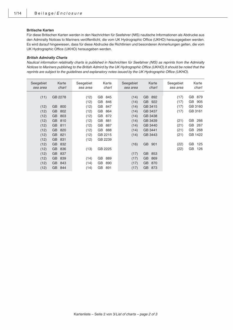
1/14 B e i l a g e / E n c l o s u r e
Britische Karten
Für diese Britischen Karten werden in den Nachrichten für Seefahrer (NfS) nautische Informationen als Abdrucke aus den Admiralty Notices to Mariners veröffentlicht, die vom UK Hydrographic Office (UKHO) herausgegeben werden. Es wird darauf hingewiesen, dass für diese Abdrucke die Richtlinien und besonderen Anmerkungen gelten, die vom UK Hydrographic Office (UKHO) herausgeben werden.
British Admiralty Charts
Nautical information relatinalty charts is published in Nachrichten für Seefahrer (NfS) as reprints from the Admiralty Notices to Mariners publisheg to the British Admird by the UK Hydrographic Office (UKHO).It should be noted that the reprints are subject to the guidelines and explanatory notes issued by the UK Hydrographic Office (UKHO).
Seegebietsea area
Kartechart
Seegebietsea area
Kartechart
Seegebietsea area
Kartechart
Seegebietsea area
Kartechart
Kartenliste – Seite 2 von 3/List of charts – page 2 of 3
(11) GB 2278
(12) GB 800 (12) GB 802 (12) GB 803 (12) GB 810 (12) GB 811 (12) GB 820 (12) GB 821 (12) GB 831 (12) GB 832 (12) GB 836 (12) GB 837 (12) GB 839 (12) GB 843 (12) GB 844
(12) GB 845 (12) GB 846 (12) GB 847 (12) GB 864 (12) GB 872 (12) GB 881 (12) GB 887 (12) GB 888 (12) GB 2215 (12) GB 2239
(13) GB 2225
(14) GB 889 (14) GB 890 (14) GB 891
(14) GB 892 (14) GB 922 (14) GB 3415 (14) GB 3437 (14) GB 3438 (14) GB 3439 (14) GB 3440 (14) GB 3441 (14) GB 3443
(16) GB 901
(17) GB 853 (17) GB 869 (17) GB 870 (17) GB 873
(17) GB 879 (17) GB 905 (17) GB 3160 (17) GB 3161
(21) GB 266 (21) GB 267 (21) GB 268 (21) GB 1422
(22) GB 125 (22) GB 126
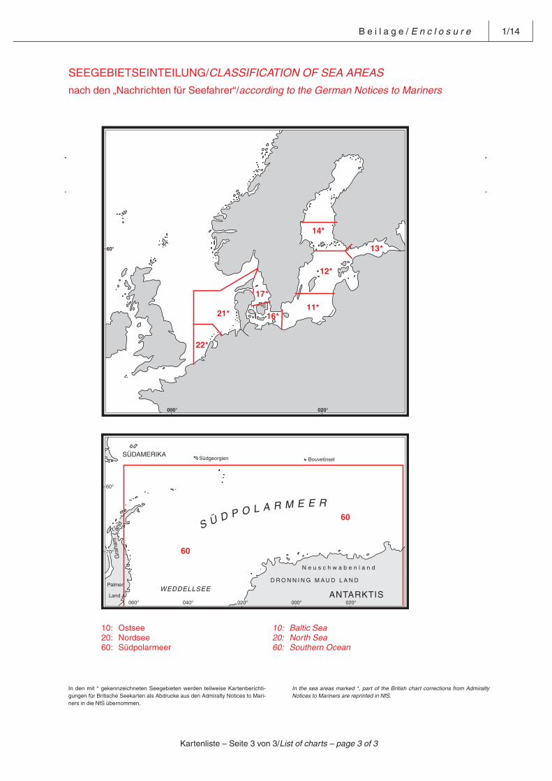
B e i l a g e / E n c l o s u r e 1/14
SEEGEBIETSEINTEILUNG/CLASSIFICATION OF SEA AREAS
nach den „Nachrichten für Seefahrer“/according to the German Notices to Mariners
21*
22*
16*11*
17
12*
14*
1360°
000° 020°
*
*
60
60°
70°
060° 040° 020° 000° 020°
60
10: Ostsee 10: Baltic Sea 20: Nordsee 20: North Sea 60: Südpolarmeer 60: Southern Ocean
In den mit * gekennzeichneten Seegebieten werden teilweise Kartenberichti-gungen für Britische See karten als Abdrucke aus den Admiralty Notices to Mari-ners in die NfS übernommen.
In the sea areas marked *, part of the British chart corrections from Admiralty Notices to Mariners are reprinted in NfS.
Kartenliste – Seite 3 von 3/List of charts – page 3 of 3
B e i l a g e / E n c l o s u r e 1/14
AnlBV (deutsch) – Seite 1 von 15/AnlBV (english) page 1 of 15
Pos: 1 /NfS/Beilagen/AnlBV/0. Überschrift @ 0\mod_1383123283768_6.docx@ 3798 @ @ 1
Verordnung über das Anlaufen derinneren Gewässer der Bundesrepub-lik Deutschland aus Seegebieten see-wärts der Grenze des deutschenKüstenmeeres und das Auslaufen
Ordinance on the requirements forvessels entering the internal watersof the Federal Republic of Germanyfrom sea areas seaward of the de-limitation of the German territorialsea and for vessels leaving such in-ternal waters
(Anlaufbedingungsverordnung –AnIBV)1
Internal Waters (Entering Require-ments) Ordinance1
Vom 18. Februar 2004 (BGBI. I S. 300), zuletzt ge-ändert durch Artikel 7 der Verordnung vom8. März 2012 (BGBl. I S. 483)
Of 18 February 2004 (BGBI. I p. 300), last amendedby Art. 7 of the Ordinance of 8 March 2012 (BGBl. Ip. 483)
(This is an unofficial English translation of the “Ver-ordnung über das Anlaufen der inneren Gewässerder Bundesrepublik Deutschland aus Seegebietenseewärts der Grenze des deutschen Küstenmeeresund das Auslaufen”; short title: “Anlaufbedingungs-verordnung”; abbreviation: “AnlBV”)
Pos: 2 /NfS/Beilagen/AnlBV/1. §1_Geltungsbereich @ 0\mod_1383136475937_6.docx@ 3801 @ @ 1
§ 1Geltungsbereich
Section 1Scope of application
(1) Schiffe, die aus Seegebieten seewärts derGrenze des deutschen Küstenmeeres kom-mend die inneren Gewässer der Bundesre-publik Deutschland anlaufen, aus diesen aus-laufen oder in diesen verkehren, haben zurVerhütung, Entdeckung, Überwachung undVerringerung von Verschmutzungen der Mee-resumwelt durch Schiffe sowie zur Erhöhungder Sicherheit und Leichtigkeit des Seever-kehrs und zur Verhütung von Unfällen die inder Anlage genannten Bedingungen für dasAn- und Auslaufen einzuhalten.
(1) Any vessel en route from sea areas seawardof the delimitation of the German territorialsea and bound for, leaving, or operating inthe internal waters of the Federal Republic ofGermany shall comply with the requirementsset out in the Annex to this Ordinance with aview to preventing, reducing, and controllingpollution of the marine environment by shipsand in order to increase the safety and effi-ciency of navigation and prevent accidents.
(2) Das Bundesamt für Seeschifffahrt und Hydro-graphie hat die Anlage nach ihrer Verkündungmindestens einmal jährlich in deutscherSprache und einer englischen Übersetzung inden „Nachrichten für Seefahrer“ bekannt zumachen.
(2) Following promulgation of the said Annex, theFederal Maritime and Hydrographic Agencyshall make known by publication in the Ger-man “Notices to Mariners” (“Nachrichten fürSeefahrer”), not less than once a year, boththe German original and an English translationof the text of the said Annex.
(3) Diese Verordnung gilt nicht (3) The present Ordinance shall not apply to1. für Schiffe, die zu hoheitlichen Zwecken
eingesetzt sind und nicht Handelszwe-cken dienen, insbesondere Dienstschiffeund Forschungsschiffe, sowie Schiffe imLotsenversetzdienst,
.1 vessels employed for government pur-poses and serving other than commercialpurposes, especially service vessels andresearch vessels, and to vessels engagedin pilot transfer services;
2. mit Ausnahme der Nummern 3.1 und 8der Anlage für Kriegsschiffe anderer Staa-ten und sonstige staatliche Schiffe, dienicht zu Handelszwecken eingesetzt wer-den,
.2 warships of other States and to otherStateowned ships operated for other thancommercial purposes – except for items3.1 and 8 of the Annex hereto, which doapply;
1 Diese Verordnung dient der Umsetzung der Richtlinien 2009/17/EG des Europäischen Parlaments und des Rates vom 23. April 2009 zur Ände-rung der Richtlinie 2002/59/EG über die Errichtung eines gemeinschaftlichen Überwachungs- und Informationssystems für den Schiffsverkehr(ABl. L 131 vom 28. Mai 2009, S. 101) sowie 2009/16/EG des Europäischen Parlaments und des Rates vom 23. April 2009 über die Hafenstaat-kontrolle (Neufassung) (ABl. L 131 vom 28. Mai 2009, S. 57).This Ordinance is to implement Directive 2009/17/EC of the European Parliament and of the Council of 23 April 2009 amending CouncilDirective 2002/59/EC establishing a Community vessel traffic monitoring and information system (Official Journal of the European Union No.L 131 of 28 May 2009, p. 101) and Directive 2009/16/EC of the European Parliament and of the Council of 23 April 2009 on port State control(recast) (Official Journal of the European Union No. L 131 of 28 May 2009, p. 57).
1/14 B e i l a g e / E n c l o s u r e
AnlBV (deutsch) – Seite 2 von 15/AnlBV (english) page 2 of 15
3. für Traditionsschiffe, deren Rumpflänge45 Meter nicht übersteigt, mit Ausnahmeder Nummer 4 der Anlage,
.3 traditional ships with a hull length not ex-ceeding 45 metres – except for item 4 ofthe Annex hereto, which does apply;
4. für Sportfahrzeuge, die für nicht mehr alszwölf Personen zugelassen sind und de-ren Rumpflänge 45 Meter nicht übersteigt,
.4 pleasure craft with a hull length not ex-ceeding 45 metres and approved to carrynot more than twelve passengers;
5. hinsichtlich Nummer 4 der Anlage fürFischereifahrzeuge, deren Rumpflänge45 Meter nicht übersteigt.
.5 with regard to item 4 of the Annex hereto– to fishing vessels with a hull length notexceeding 45 metres.
(4) Diese Verordnung gilt ferner nicht für Bunkerauf Schiffen unter 1 000 BRZ, Bordvorräteund Schiffsausrüstung.
(4) The present Ordinance shall not apply, either,to bunkers aboard ships of less than1 000 GT, to ships’ stores, and to the ships’equipment.
Pos: 3 /NfS/Beilagen/AnlBV/2. §2_Folgen von Verstößen @ 0\mod_1383136851254_6.docx@ 3804 @ @ 1
§ 2Folgen von Verstößen
Section 2Consequences of contraventions
(1) Ein Schiff, dessen Schiffsführer, Betreiberoder Agent die in der Anlage festgelegtenBedingungen für das An- und Auslaufen nichterfüllt hat, wird von der jeweils zuständigenVerkehrszentrale zunächst auf diesen Um-stand hingewiesen. Werden die vorgeschrie-benen Meldungen dennoch nicht abgegeben,können die zuständigen Behörden diesenUmstand als hinreichenden Verdacht einesVerstoßes gegen die anwendbaren Schiffs-sicherheitsvorschriften ansehen und eineKontrolle des Schiffes im Bereich der deut-schen Hoheitsbefugnisse durchführen.
(1) Any vessel the master, operator or agent ofwhich has failed to comply with the require-ments for entering, respectively leaving, theinternal waters of the Federal Republic ofGermany as set out in the Annex hereto shallbe notified of such non-compliance by theappropriate Vessel Traffic Services (VTS). Ifthe required reports are not made despitesuch notification, the competent authoritiesmay regard this as sufficient grounds for sus-pecting a contravention of applicable shipsafety requirements and may conduct an in-spection of the vessel in the area of jurisdic-tion of the Federal Republic of Germany.
(2) Jedes Schiff, dessen Betreiber, Agent oderSchiffsführer gegen die Meldepflicht nachNummer 2.1.2 oder 2.2.2 der Anlage verstößt,wird im deutschen Bestimmungshafen einererweiterten Überprüfung im Sinne des Arti-kels 14 der Richtlinie 2009/16/EG des Euro-päischen Parlaments und des Rates vom23. April 2009 über die Hafenstaatkontrolle(Neufassung) (ABl. L 131 vom 28. Mai 2009,S. 57) in der jeweils geltenden Fassung un-terzogen.
(2) Any vessel the operator, agent or master ofwhich has failed to comply with the reportingrequirement set out in item 2.1.2 or 2.2.2 ofthe Annex hereto shall, when in the Germanport of destination, be subject to an expand-ed inspection under the provisions of Article14 of Council Directive 2009/16/EC of the Eu-ropean Parliament and of the Council of23 April 2009 on Port State Control (recast)(Official Journal of the European Union NoL 131 of 28 May 2009, p. 57).
Pos: 4 /NfS/Beilagen/AnlBV/3. §3_Ordnungswidrigkeiten @ 0\mod_1383138823370_6.docx@ 3807 @ @ 1
§ 3Ordnungswidrigkeiten
Section 3Administrative Offences
(1) Ordnungswidrig im Sinne des § 15 Abs. 1 Nr.2 des Seeaufgabengesetzes handelt, wervorsätzlich oder fahrlässig entgegen § 1 Abs.1 in Verbindung mit den Nummern 2.1.1,2.1.2, 2.2.1 oder 2.2.2 der Anlage eine Mel-dung nicht, nicht richtig, nicht vollständigoder nicht rechtzeitig macht.
(1) An administrative offence under Section 15,para. 1, item 2, Seeaufgabengesetz, shall bedeemed to have been committed by anyonewho willfully or negligently, in contravention ofSection 1, para. 1, in conjunction with items2.1.1, 2.1.2, 2.2.1 or 2.2.2 of the Annex, failsto make a report or fails to make a report cor-rectly, completely or in time.
(1a) Ordnungswidrig im Sinne des § 15 Abs. 1 Nr.2 des Seeaufgabengesetzes handelt, wer alsSchiffsführer vorsätzlich oder fahrlässig
(1a) An administrative offence under Section 15,para. 1, no. 2, Seeaufgabengesetz, shall bedeemed to have been committed by anyonewho, as master of ship, willfully or negligently
1. entgegen § 1 Abs. 1 in Verbindung mitNummer 9.1 Satz 1 der Anlage einen Ha-fen anläuft,
.1 in contravention of Section 1, para. 1, inconjunction with item 9.1, sentence 1, ofthe Annex, calls at a port;
2. entgegen § 1 Abs. 1 in Verbindung mitNummer 9.1 Satz 2 der Anlage die dortvorgeschriebene Umstellung nicht odernicht rechtzeitig vornimmt,
.2 in contravention of Section 1, para. 1, inconjunction with item 9.1, sentence 2, ofthe Annex, fails to make the requiredswitch-over, or fails to make it in due time;
3. entgegen § 1 Abs. 1 in Verbindung mitNummer 9.2 Satz 1 der Anlage die dortvorgeschriebenen Angaben nicht, nichtrichtig, nicht vollständig oder nicht recht-zeitig übermittelt oder
.3 in contravention of Section 1, para. 1, inconjunction with number 9.2, sentence 1,of the Annex, fails to provide the requiredinformation or fails to provide it correctly,completely, or in due time; or
B e i l a g e / E n c l o s u r e 1/14
AnlBV (deutsch) – Seite 3 von 15/AnlBV (english) page 3 of 15
4. entgegen § 1 Abs. 1 in Verbindung mitNummer 9.2 Satz 2 der Anlage eine Ein-tragung nicht oder nicht rechtzeitignachmeldet.
.4 in contravention of Section 1, para. 1, inconjunction with number 9.2, sentence 2,of the Annex, fails to report an entry sub-sequently or fails to report it subsequentlyand in due time.
(2) Die Zuständigkeit für die Verfolgung undAhndung von Ordnungswidrigkeiten nachAbsatz 1 und Absatz 1a wird auf die Wasser-und Schifffahrtsdirektionen Nord und Nord-west2 übertragen.
(2) Responsibility for the prosecution and pun-ishment of administrative offences under pa-ras. 1 and 1a is assigned to the Waterwaysand Shipping Directorates North and North-west2.
Pos: 5 /Module für alle Dokumente/Seitenumbruch @ 0\mod_1382702309853_0.docx@ 3729 @ @ 1
2 Seit 1. Mai 2013 Generaldirektion Wasserstraßen und Schifffahrt, Außenstellen Nord und NordwestSince 1 May 2013 Federal Waterways and Shipping Agency, Northern and Northwestern Region Offices
1/14 B e i l a g e / E n c l o s u r e
AnlBV (deutsch) – Seite 4 von 15/AnlBV (english) page 4 of 15
Pos: 6 /NfS/Beilagen/AnlBV/4. Anlage zu §1 Abs. 1 @ 0\mod_1383139441598_6.docx@ 3810 @ @ 1
Anlage(zu § 1 Abs. 1)
Annex(to Section 1 [1])
Pos: 7 /NfS/Beilagen/AnlBV/4.1 Begriffsbestimmungen @ 0\mod_1383546165539_6.docx@ 3818 @ @ 1
1 Begriffsbestimmungen 1 DefinitionsIm Sinne dieser Verordnung sind For the purposes of the present Ordinance,
the terms given hereunder shall have the fol-lowing meaning:
1.1 „Betreiber“: Eigentümer, Reeder, Chartereroder Manager des Schiffes;
1.1 The term “operator” means the owner, char-terer or manager of a given ship;
1.2 „Agent“: jede Person, die dazu befugt oderbeauftragt ist, im Namen des Schiffsbetrei-bers alle Schiffs- und Ladungsinformationenzu übermitteln;
1.2 the term “agent” means any person empow-ered, authorized or instructed to transmit anyship-related or cargo-related information onbehalf of the ship’s operator;
1.3 „gefährliche Güter“: 1.3 the term “dangerous goods” includes– Stoffe und Gegenstände, die unter die je-
weiligen Begriffsbestimmungen für dieKlassen 1 bis 9 des IMDG-Codes fallen,
– substances and objects falling within thepertinent definitions for Classes 1 to 9 ofthe IMDG Code;
– Stoffe, die bei der Beförderung alsSchüttladung im IMSBC-Code als gefähr-liche Güter klassifiziert sind, oder
– substances which in the IMSBC Code areclassified as dangerous goods when car-ried as bulk cargo;
– Stoffe, die in Tankschiffen befördert wer-den sollen und
– substances to be carried in tankers and towhich any one of the three conditions be-low applies:
a) denen eine UN-Nummer zugeordnetworden ist oder
a) a UN Number has been assigned tothem; or
b) die in Kapitel 17 des IBC-Codes auf-geführt sind und denen dort eine Ver-schmutzungskategorie zugeordnet istund die in Kapitel 18 des IBC-Codesaufgeführt sind und denen dort eineVerschmutzungskategorie zugeordnetist oder
b) they are listed in Chapter 17 of the IBCCode, where they have been assigneda pollution category; and they arelisted in Chapter 18 of the IBC Code,where they have been assigned a pol-lution category; or
c) die in Kapitel 19 des IGC-Codes auf-geführt sind,
c) they are listed in Chapter 19 of theIGC Code;
– die im INF-Code genannten radioaktivenStoffe;
– the radioactive substances specified inthe INF Code;
1.4 „umweltschädliche Güter“: 1.4 the term “goods damaging to the environ-ment” includes
– Rohöl und Mineralölerzeugnisse laut Be-griffsbestimmung in Anlage I des MAR-POL-Übereinkommens,
– crude oil and refined products as definedin Annex I of the MARPOL Convention;
– flüssige Schadstoffe laut Begriffsbestim-mung in Anlage II des MARPOL-Über-einkommens,
– noxious liquid substances as defined inAnnex II of the MARPOL Convention;
– Schadstoffe laut Begriffsbestimmung inAnlage III des MARPOL-Überein-kommens;
– harmful substances as defined in Annex IIIof the MARPOL Convention;
1.5 „MARPOL-Übereinkommen“: das Interna-tionale Übereinkommen von 1973 zur Verhü-tung der Meeresverschmutzung durch Schiffeund das dazugehörige Protokoll von 1978(BGBl. 1982 II S. 2), in der jeweils nach Maß-gabe des deutschen Rechts geltendenFassung;
1.5 the term “MARPOL Convention” means theInternational Convention for the Prevention ofPollution from Ships, 1973, and the Protocolof 1978 relating thereto (promulgated in theFederal Law Gazette 1982 II p. 2) as amendedand valid under German law;
1.6 „Kollisionsverhütungsregeln“: die Internatio-nalen Regeln von 1972 zur Verhütung vonZusammenstößen auf See (BGBl. 1977 IS. 813), in der jeweils nach Maßgabe desdeutschen Rechts geltenden Fassung;
1.6 the term “Collision Regulations” means theInternational Regulations for Preventing Colli-sions at Sea, 1972 (promulgated in the Fed-eral Law Gazette 1977 I p. 813) as amendedand valid under German law;
1.7 „IMDG-Code“: der International MaritimeDangerous Goods Code, in der amtlichendeutschen Übersetzung, bekannt gegebendurch die Bekanntmachung vom 28. Februar2009 (VkBl. 2009 S. 102);
1.7 the term “IMDG Code” means the Interna-tional Maritime Dangerous Goods Code in itsofficial German translation as made known tothe public by Notice of 28 February 2009(promulgated in the Verkehrsblatt 2009 p.102);
B e i l a g e / E n c l o s u r e 1/14
AnlBV (deutsch) – Seite 5 von 15/AnlBV (english) page 5 of 15
1.8 „IBC-Code“: der Internationale Code für denBau und die Ausrüstung von Schiffen zur Be-förderung gefährlicher Chemikalien als Mas-sengut (BAnz. Nr. 125a vom 12. Juli 1986), inder jeweils nach Maßgabe des deutschenRechts geltenden Fassung;
1.8 the term “IBC Code” means the InternationalCode for the Construction and Equipment ofShips Carrying Dangerous Chemicals in Bulk(promulgated in the Bundesanzeiger No 125aof 12 July 1986) as amended and valid underGerman law;
1.9 „IGC-Code“: der Internationale Code für denBau und die Ausrüstung von Schiffen zur Be-förderung verflüssigter Gase als Massengut(BAnz. Nr. 125a vom 12. Juli 1986), in derjeweils nach Maßgabe des deutschen Rechtsgeltenden Fassung;
1.9 the term “IGC Code” means the InternationalCode for the Construction and Equipment ofShips Carrying Liquefied Gases in Bulk(promulgated in the Bundesanzeiger No 125aof 12 July 1986) as amended and valid underGerman law;
1.10 „IMSBC-Code“: der International MaritimeSolid Bulk Cargoes Code in der amtlichendeutschen Übersetzung bekannt gegeben am15. Dezember 2009 (VkBl. 2009 S. 775);
1.10 the term “IMSBC Code” means the Interna-tional Maritime Solid Bulk Cargoes Code inthe official German translation promulgatedon 15 December 2009 (promulgated in theVerkehrsblatt 2009, p. 775);
1.11 „INF-Code“: der Internationale Code für diesichere Beförderung von verpackten be-strahlten Kernbrennstoffen, Plutonium undhochradioaktiven Abfällen (BAnz. 2000 S.23 322) in der jeweils nach Maßgabe desdeutschen Rechts geltenden Fassung;
1.11 the term “INF Code” means the Code for theSafe Carriage of Irradiated Nuclear Fuel, Plu-tonium and High-Level Radioactive Wastes inFlasks on Board Ships (promulgated in theBundesanzeiger 2000 p. 23 322) as amendedand valid under German law;
1.12 „Hafenbehörde“: Behörde oder sonstige Stel-le, die für die Entgegennahme und Weiterga-be von Hafenanlaufmeldungen zuständig ist;
1.12 the term “port authority” means the authorityor other organisation in charge of receivingand passing on the reports of vessels callingat a given port;
1.13 „Maritime Verkehrssicherung“: die von derVerkehrszentrale zur Verhütung von Kolli-sionen und Grundberührungen, zur Verkehrs-ablaufsteuerung oder zur Verhütung von derSchifffahrt ausgehender Gefahren für dieMeeresumwelt gegebenen Verkehrsinforma-tionen und Verkehrsunterstützungen sowieerlassenen Verfügungen zur Verkehrsrege-lung und -lenkung;
1.13 the term “maritime traffic control” means anytraffic information and traffic assistance pro-vided by the competent VTS Centre to pre-vent collisions and groundings, control thetraffic flow, or prevent hazards to the marineenvironment as may arise from shipping; andany orders imposed to control and regulatetraffic;
1.14 „Verkehrsinformationen“: nautische Warn-nachrichten sowie Mitteilungen der Verkehrs-zentrale über die Verkehrslage, Fahrwasser-sowie Wetter- und Tideverhältnisse, die zufestgelegten Zeiten in regelmäßigen Abstän-den oder auf Anforderung einzelner Schiffegegeben werden;
1.14 the term “traffic information” means naviga-tional warnings or other information providedby the competent VTS Centre, either at pre-determined times and at regular intervals orupon the specific request of individual ves-sels;
1.15 „Verkehrsunterstützungen“: Hinweise undWarnungen der Verkehrszentrale an dieSchifffahrt und Empfehlungen im Rahmen ei-ner Schiffsberatung von der Verkehrszentraleaus durch Seelotsen nach § 23 Abs. 1 desGesetzes über das Seelotswesen, die beiverminderter Sicht, auf Anforderung oderwenn die Verkehrszentrale es auf Grund derVerkehrsbeobachtung für erforderlich hält,gegeben werden und sich entsprechend denErfordernissen der Verkehrslage, der Fahr-wasser- sowie der Wetter- und Tideverhält-nisse auch auf Positionen, Passierzeiten,Kurse, Geschwindigkeiten oder Manöver be-stimmter Schiffe erstrecken können;
1.15 the term “traffic assistance” means adviceand warnings to the shipping community pro-vided by the competent VTS Centre as wellas recommendations provided through thecompetent VTS Centre by sea pilots advisingships under the provisions of Section 23 (1) ofthe Sea Pilotage Act; such advice, warnings,and recommendations to be provided in re-stricted visibility, upon request, or when thecompetent VTS Centre, upon evaluation ofthe traffic situation, deems it necessary toprovide them; they may cover such aspectsas the positions of given vessels, their timesof passage at given positions, their courses,speeds, and/or manœuvres (as the traffic sit-uation, the fairway, weather, and/or tidal con-ditions may require);
1.16 „Verkehrsregelungen“: schifffahrtspolizeilicheVerfügungen der Verkehrszentrale im Einzel-fall, die entsprechend den Erfordernissen derVerkehrslage, der Fahrwasser- sowie derWetter- und Tideverhältnisse Regelungenüber Vorfahrt, Überholen, Begegnen, Höchst-und Mindestgeschwindigkeiten oder über dasBefahren einer Seeschifffahrtsstraße um-fassen können;
1.16 the term “traffic instructions” means restraintsimposed, on a case-by-case basis, by thecompetent VTS Centre acting as shipping po-lice authority; traffic instructions may coveraspects such as right-of-way, overtaking andhead-on situations, minimum and maximumspeeds, or any other details to be observedby vessels proceeding on a given navigablewaterway (as the traffic situation, the fairway,weather, and/or tidal conditions may require);
1/14 B e i l a g e / E n c l o s u r e
AnlBV (deutsch) – Seite 6 von 15/AnlBV (english) page 6 of 15
1.17 „Innere Deutsche Bucht“ (German Bight): dasSeegebiet ergibt sich aus dem Anhang zudieser Anlage;
1.17 the term “Inner German Bight” denotes thesea area as depicted in the Appendix to thepresent Annex;
1.18 „UN-Nummer“: die zum Stoff gehörendeNummer gemäß den Empfehlungen, die vomAusschuss der Sachverständigen der Verein-ten Nationen für die Beförderung gefährlicherGüter vorgeschlagen wurde und in den in denNummern 1.7 bis 1.10 dieser Anlage genann-ten Codes aufgeführt ist;
1.18 the term “UN Number” means the identifica-tion number assigned to a given substancepursuant to the recommendations of theUnited Nations Committee of Experts on theTransport of Dangerous Goods and specifiedin one or more of the Codes referred to initems 1.7 to 1.10 of this Annex;
1.19 „AIS“: Automatisches Schiffsidentifizierungs-system der Regel V/19.2.4 des Internatio-nalen Übereinkommens von 1974 zumSchutz des menschlichen Lebens auf See(BGBl. 1979 II S. 141), in der jeweils nachMaßgabe des deutschen Rechts geltendenFassung.
1.19 the term “AIS” means the Automatic Iden-tification System referred to in RegulationV/19.2.4 of the International Convention forthe Safety of Life at Sea, 1974 (promulgatedin the Federal Law Gazette 1979 II p. 141) asamended and valid under German law.
Pos: 8 /NfS/Beilagen/AnlBV/4.2 Meldungen an die Zentralstelle @ 0\mod_1383554511558_6.docx@ 3827 @ @ 1
2 Meldungen an die Zentrale Meldestelle 2 Reports to be made to the CompetentAuthority (Zentrale Meldestelle)
2.1 Allgemeine Meldungen 2.1 General notification
2.1.1 Meldung vor Einlaufen nach der Richtlinie2002/59/EG des Europäischen Parlamentsund des Rates vom 27. Juni 2002 über dieEinrichtung eines gemeinschaftlichen Über-wachungs- und Informationssystems für denSchiffsverkehr (ABl. L 208 vom 5. August2002, S. 10), die zuletzt durch die Richtlinie2009/17/EG (ABl. L 131 vom 28. Mai 2009,S. 101) geändert worden ist, in der jeweilsgeltenden Fassung
2.1.1 Notification prior to entry according to Di-rective 2002/59/EC of the European Parlia-ment and of the Council of 27 June 2002 es-tablishing a Community vessel traffic moni-toring and information system (Official Journalof the European Union No. L 208 of 5 August2002, p. 10), last amended by Directive2009/17/EC (Official Journal of the EuropeanUnion No. L 131 of 28 May 2009, p. 101), asamended
Der Betreiber, Agent oder Schiffsführer einesSchiffes, das im Geltungsbereich dieser Ver-ordnung verkehrt, ist verpflichtet,
The operator, agent or master of a ship oper-ating in the area of this Ordinance is requiredto notify the information referred to insentence 2 to the Competent Authority:
a) mindestens 24 Stunden im Voraus oder a) at least 24 hours in advance; orb) spätestens zu dem Zeitpunkt, zu dem das
Schiff aus dem vorigen Hafen ausläuft,sofern die Reisezeit weniger als 24 Stun-den beträgt, oder
b) at the latest, at the time the ship leavesthe previous port, if the voyage time isless than 24 hours; or
c) wenn der Anlaufhafen nicht bekannt istoder sich während der Reise ändert, so-bald diese Information vorliegt,
c) if the port of call is not known or ischanged during the voyage, as soon asthis information is available.
die in Satz 2 bezeichneten Angaben der Zent-ralen Meldestelle zu übermitteln. Angaben imSinne des Satzes 1 sind:
Information within the meaning of sentence 1shall be:
a) Identifikation des Schiffes (Name, Rufzei-chen und IMO-Schiffsidentifikations-nummer),
a) ship identification (name, call sign, IMOidentification number);
b) Identifizierungsmerkmal des Bestim-mungshafens,
b) identification code of the port of call;
c) Voraussichtliche Zeit der Ankunft im Be-stimmungshafen oder an der Lotsensta-tion und voraussichtliche Zeit des Auslau-fens aus diesem Hafen und
c) estimated time of arrival at the port of callor pilot station and estimated time of de-parture from that port; and
d) Gesamtzahl der an Bord befindlichen Per-sonen.
d) total number of persons on board.
2.1.2 Meldungen nach Ein- und Auslaufen nach derRichtlinie 2009/16/EG des Europäischen Par-laments und des Rates vom 23. April 2009über die Hafenstaatkontrolle (Neufassung)(ABl. L 131 vom 28. Mai 2009, S. 57) in derjeweils geltenden Fassung
2.1.2 Notification to be made after entering or leav-ing, according to Directive 2009/16/EC of theEuropean Parliament and of the Council of23 April 2009 on port State control (recast)(Official Journal of the European Union No.L 131 of 28 May 2009, p. 57), as amended
Ergänzend zur Meldung nach Nummer 2.1.1ist der Betreiber, Agent oder Schiffsführer ei-nes Schiffes unter fremder Flagge, das einen
Supplementing the report under 2.1.1 above,the operator, agent or master of a ship underforeign flag entering or leaving a German port
B e i l a g e / E n c l o s u r e 1/14
AnlBV (deutsch) – Seite 7 von 15/AnlBV (english) page 7 of 15
deutschen Hafen oder ein anderes Gebiet imZuständigkeitsbereich eines deutschen Ha-fens anläuft oder ihn verlässt, verpflichtet,
or other area in a German port’s area of re-sponsibility is required to report immediatelyto the Competent Authority
a) nach dem Einlaufen den genauen Zeit-punkt der Ankunft des Schiffes und
a) after arrival, the exact time of arrival of theship
b) nach dem Auslaufen den genauen Zeit-punkt des Auslaufens des Schiffes
b) after departure, the exact time of depar-ture of the ship
sowie jeweils das Identifizierungsmerkmaldes Hafens unverzüglich der Zentralen Mel-destelle zu übermitteln.
and identification code of the port.
2.2 Besondere Meldungen 2.2 Special notification
2.2.1 Meldung vor Einlaufen und vor Auslaufen fürGefahrguttransporte nach der Richtlinie2002/59/EG
2.2.1 Notification prior to entry and before depar-ture of ships carrying dangerous or pollutinggoods in accordance with Directive2002/59/EC
Der Betreiber, Agent oder Schiffsführer einesSchiffes, das gefährliche oder umweltschäd-liche Güter befördert, hat, wenn der nächsteAnlaufhafen, Auslaufhafen, Liege- oder An-kerplatz im Geltungsbereich dieser Verord-nung liegt oder eine Durchfahrt durch denNord-Ostsee-Kanal beabsichtigt ist, spätes-tens beim Verlassen des letzten Auslaufha-fens der Zentralen Meldestelle folgende An-gaben zu übermitteln:
If the next port of call, port of departure oranchorage of a ship carrying dangerous orpolluting goods is located in the area coveredby this ordinance or such ship is planning topass through Kiel Canal, her operator, agentor master is required to notify the followinginformation to the Competent Authority, atthe latest at the moment of departure fromthe last port of call:
a) Identifikation des Schiffes (Name, Rufzei-chen und IMO-Schiffsidentifikations-nummer);
a) ship identification (name, call sign, IMOidentification number);
b) letzter Auslaufhafen und Zeit des Auslau-fens aus diesem Hafen;
b) last port of call and time of departure fromthat port;
c) nächster Anlaufhafen, Liege- oder Anker-platz;
c) next port of call or anchorage
d) voraussichtliche Ankunftszeit im nächstenAnlaufhafen, Liege- oder Ankerplatz oderan der Lotsenstation;
d) estimated time of arrival at the next port ofcall or anchorage or at the pilot station;
e) Gesamtzahl der an Bord befindlichen Per-sonen;
e) total number of persons on board;
f) gefährliche oder umweltschädliche Gütermit dem Richtigen Technischen Namenbeziehungsweise dem Stoff- oder Pro-duktnamen und bei brennbaren Flüssig-keiten nach dem IMDG-Code demFlammpunkt;
f) dangerous or polluting goods carried,stating their correct technical namesand/or substance or product names and,in the case of flammable liquids accordingto the IMDG Code, their flash point;
g) die Gefahr auslösenden Stoffe und dievon den Vereinten Nationen zugeteiltenUN-Nummern;
g) hazardous substances carried, and UNnumbers assigned to them by the UnitedNations
h) die nach IMDG-Code bestimmte Gefahr-gutklasse und Kategorie des Schiffes imSinne des INF-Codes;
h) IMDG dangerous goods class and shipcategory according to the INF Code;
i) die Mengen der in Buchstabe g genann-ten Güter und ihr Aufbewahrungsort anBord, Verpackungsart und Verpackungs-gruppe sowie, soweit sie in anderen Be-förderungseinheiten als festen Tanks be-fördert werden, die Art derBeförderungseinheit und deren Identifika-tionsnummer;
i) quantities of the goods referred to in item(g) above and their locations on board thevessel, the type of package used and thepackaging group and, when carried intransport units other than fixed tanks, thetype of each transport unit and its identifi-cation number;
j) Lade- und Löschhafen der Ladung; j) loading and unloading ports of the cargo;k) Bestätigung, dass eine Aufstellung, ein
Verzeichnis oder ein Lageplan in geeigne-ter Form zur Angabe der an Bord desSchiffes geladenen gefährlichen oderumweltschädlichen Güter und ihrer jewei-ligen Lage im Schiff beziehungsweise einentsprechender Stauplan auf der Brückeoder in der Schiffsführungszentrale vor-gehalten wird;
k) a confirmation that a list, manifest or ap-propriate location plan giving details of thedangerous goods or goods damaging tothe environment carried on board the ves-sel, including their location on the vessel,or an appropriate stowage plan, is keptreadily available on the navigating bridgeor in the operations control room;
1/14 B e i l a g e / E n c l o s u r e
AnlBV (deutsch) – Seite 8 von 15/AnlBV (english) page 8 of 15
l) eine Adresse, unter der detaillierte Infor-mationen über die Ladung erhältlich sind,sowie die Notrufdaten des Versendersoder jeder anderen Person oder Einrich-tung, die im Besitz von Informationenüber die physikalisch chemischen Merk-male der Erzeugnisse und über die imNotfall zu ergreifenden Maßnahmen ist;
l) an address where detailed information onthe cargo may be obtained, and emer-gency contact data of the shipper or anyother person who has information aboutthe physical and chemical properties ofthe products and about measures to betaken in an emergency;
m) die Menge der als vorhergehende Ladungbeförderten Massengüter im Sinne des§ 30 Absatz 1 Nummer 1 der Seeschiff-fahrtsstraßen-Ordnung, soweit die Tanksnicht gereinigt und entgast oder vollstän-dig inertisiert sind;
m) the quantity of preceding bulk cargo thathas been carried, within the meaning ofSection 30 (1), item 1, German TrafficRegulations for Navigable Maritime Wa-terways, unless the tanks have beencleaned and degassed or fully inerted;
n) Merkmale und geschätzte Menge desmitgeführten Bunkertreibstoffs.
n) characteristics and estimated quantity ofbunker fuel carried.
Soweit die Angaben nach den Buchstaben c,d und j beim Verlassen des letzten Auslaufha-fens nicht verfügbar sind, ist die vollständigeMeldung erneut zu machen, sobald dernächste Anlaufhafen, Liege oder Ankerplatzbekannt ist.
Where the information under c, d and j aboveis not available when leaving the previous portof departure, the complete information mustbe notified once more as soon as the port ofdestination or anchorage is known.
2.2.2 Meldung vor Einlaufen für erweiterte Über-prüfung nach der Richtlinie 2009/16/EG
2.2.2 Notification prior to entry in case of expandedinspection in accordance with Directive2009/16/EC
Der Betreiber, Agent oder Schiffsführer einesSchiffes unter fremder Flagge, das nach Arti-kel 14 der Richtlinie 2009/16/EG für eine er-weiterte Überprüfung in Betracht kommt, hatder Zentralen Meldestelle 72 Stunden vor dererwarteten Ankunft in einem deutschen Hafenoder einem anderen Gebiet im Zuständig-keitsbereich eines deutschen Hafens folgen-de Angaben zu melden:
The operator, agent or master of a foreign-flagged ship which, under Section 14 of Di-rective 2009/16/EC, is eligible for an expand-ed inspection must notify the following infor-mation to the Competent Authority 72 hoursbefore the estimated time of arrival in a Ger-man port or other area in the responsibility ofa German port:
a) Identifikation des Schiffes (Name, Rufzei-chen und IMO-Schiffsidentifikations-nummer);
a) ship identification (name, call sign, IMOidentification number);
b) Identifizierungsmerkmal des Hafens, derangelaufen werden soll;
b) identification of the next port of call
c) vorgesehene Dauer der Liegezeit, ein-schließlich des voraussichtlichen Zeit-punkts der Ankunft und des Auslaufens;
c) planned duration of stay including ex-pected times of arrival and departure;
d) für Tankschiffe: d) with respect to tankers:aa) Bauweise: einfache Hülle, einfache
Hülle mit getrenntem Ballasttank(SBT), Doppelhülle;
aa) type of construction: single hull, singlehull with separate ballast tank (SBT,double hull;
bb)Zustand der Lade- und Ballasttanks:voll, leer, inertisiert;
bb)status of cargo and ballast tanks: full,empty, inerted;
cc) Ladungsart und -volumen; cc) type and volume of cargo;e) geplante Tätigkeiten im Bestimmungs-
hafen oder am Bestimmungsankerplatz(Laden, Löschen, sonstige);
e) planned activities in the port of destinationor anchorage (loading, unloading, other);
f) geplante vorgeschriebene Kontrollüber-prüfungen und wesentliche Instandhal-tungs- und Instandsetzungsarbeiten, diewährend des Aufenthalts im Bestim-mungshafen durchzuführen sind;
f) planned mandatory inspections and majormaintenance and repair measures plannedto be carried out during the ship’s stay inthe port of destination;
g) Datum der letzten erweiterten Überprü-fung in der unter die Pariser Vereinbarungfallenden Region.
g) date of the previous expanded inspectionin the region covered by the Paris Agree-ment.
2.3 Zentrale Meldestelle und Meldeverfahren 2.3 Competent Authority and reporting proce-dures
2.3.1 Zentrale Meldestelle 2.3.1 Competent AuthorityZentrale Meldestelle im Sinne dieser Verord-nung ist das Maritime Lagezentrum des Ha-variekommandos (Zentrale Meldestelle),
The Competent Authority referred to in thisOrdinance is the Maritime Emergency Report-ing and Assessment Centre (Competent Au-thority) located at
B e i l a g e / E n c l o s u r e 1/14
AnlBV (deutsch) – Seite 9 von 15/AnlBV (english) page 9 of 15
Am Alten Hafen 2, 27472 Cuxhaven,Tel.: + 49 (0) 47 21 5 67-4 99,Fax: + 49 (0) 47 21 5 54-7 44 oder -7 45.Die Zentrale Meldestelle betreibt zur Annah-me der Meldungen im Internet das ZentraleMeldesystem für Gefahrgut und Schiffs-verkehre der Bundesrepublik Deutschland(ZMGS).
Am Alten Hafen 2, 27472 Cuxhaven,phone: + 49 (0) 47 21 5 67-4 99,Fax: + 49 (0) 47 21 5 54-7 44 or -7 45.The Competent Authority operates the Inter-net based central reporting system for dan-gerous goods and ship transports (ZMGS),which processes the reports submitted.
2.3.2 Ersatzmeldestelle bei erweiterten Überprü-fungen
2.3.2 Designated replacement coastal station forexpanded inspections
Ist dem Betreiber, Agent oder Schiffsführereine Meldung nach Nummer 2.2.2 an dieZentrale Meldestelle nicht möglich, müssendie Angaben als elektronisches Dokument andie Berufsgenossenschaft für Verkehr undTransportwirtschaft, Ottenser Hauptstraße54, 22765 Hamburg(E-Mail: [email protected])gemeldet werden.
If the operator, agent or master of a ship isunable to notify the information required un-der 2.2.2 above to the Competent Authority,the information has to be sent as an electron-ic document to Berufsgenossenschaft fürVerkehr und Transportwirtschaft, OttenserHauptstraße 54, 22765 Hamburg(e-mail: [email protected]).
2.3.3 Meldeverfahren 2.3.3 Reporting procedure
Der Betreiber, Agent oder Schiffsführer hatdie nach den Nummern 2.1 und 2.2 erforder-lichen Meldungen im ZMGS über das Internetunter www.zmgs.de vorzunehmen. Die Mel-dung muss Namen, Anschrift, Ruf- und Tele-fax-Nummer des Meldenden enthalten. Dermeldende Betreiber, Agent oder Schiffsführerhat sicherzustellen, dass die erforderlichenMeldungen je Schiffsreise nur einmal abge-geben werden.
The operator, agent or master of a ship is re-quired to notify the information under 2.1 and2.2 via Internet to ZMGS at www.zmgs.de.The report must include the name, address,telephone and fax numbers of the personmaking the report. The operator, agent, ormaster of the ship must ensure that the re-quired information is notified only once foreach voyage.
2.4 Möglichkeit der befreienden Meldung an eineHafenbehörde
2.4 Exonerating option to make reports to a portauthority
Der Betreiber, Agent oder Schiffsführer einesSchiffes ist von der Meldung der Angabennach den Nummern 2.1.1, 2.1.2 und 2.2.1 andie Zentrale Meldestelle befreit, wenn er die-se Angaben einer Hafenbehörde gemeldethat und die Hafenbehörde in der Lage ist, dieAngaben der Zentralen Meldestelle auf derenAnfrage 24 Stunden am Tag unverzüglich imWege der Datenfernübertragung zu übermit-teln. Die Hafenbehörden, die diese Voraus-setzung erfüllen, werden vom Bundesministe-rium für Verkehr, Bau und Stadtentwicklungim Verkehrsblatt und nachrichtlich auf der In-ternetseite der Zentralen Meldestelle unterwww.zmgs.de bekannt gemacht.
The operator, agent or master of a ship shallbe exempted from notifying the informationunder 2.1.1, 2.1.2 and 2.2.1 to the CompetentAuthority if he has notified the information toa port authority and provided that such portauthority is in a position to forward the infor-mation to the Competent Authority upon thelatter’s request, 24 hours a day, without delayvia remote data transmission. The names ofport authorities meeting these requirementswill be published by the Federal Ministry ofTransport, Building and Urban Developmentby promulgation in the Verkehrsblatt and willbe notified on the homepage of the Compe-tent Authority at www.zmgs.de
2.5 Ausnahmeregelung für Liniendienste 2.5 Exemptions for scheduled services
2.5.1 Nationale Liniendienste 2.5.1 National scheduled services
Liniendienste zwischen deutschen Häfen sindvon der Pflicht zur Abgabe der Meldungennach Nummer 2.2.1 befreit, soweit der Be-treiber des jeweiligen Liniendienstes eine Lis-te der betreffenden Schiffe erstellt und aktua-lisiert sowie diese als elektronischesDokument an die Zentrale Meldestelle (E-Mail: [email protected]) übermittelthat. Der Betreiber des jeweiligen Liniendiens-tes hat sicherzustellen, dass die Angabennach Nummer 2.2.1 24 Stunden am Tag aufAnforderung der Zentralen Meldestelle unver-züglich übermittelt werden können.
Scheduled services operating between Ger-man ports shall be exempted from the obliga-tion to notify the information under 2.2.1above provided that the company operatingthe scheduled services keeps and updates alist of the ships concerned and transmits it asan electronic document to the CompetentAuthority at [email protected]. Thecompany operating the scheduled servicesmust ensure that the information to be noti-fied under 2.2.1 can be transmitted to theCompetent Authority 24 hours a day andwithout delay.
1/14 B e i l a g e / E n c l o s u r e
AnlBV (deutsch) – Seite 10 von 15/AnlBV (english) page 10 of 15
2.5.2 Internationale Liniendienste 2.5.2 International scheduled services
Einem internationalen Liniendienst kann aufschriftlichen Antrag bei der für den Auslauf-hafen örtlich zuständigen Wasser- und Schiff-fahrtsdirektion3 eine Ausnahme genehmigtwerden, soweit die übrigen Mitgliedstaatender Europäischen Union zugestimmt haben.Nach Erteilung der Genehmigung gilt Num-mer 2.5.1 entsprechend.
An exemption may be granted to an interna-tional scheduled service, upon application, bythe competent local Waterways and ShippingDirectorate3, provided that the other MemberStates of the European Union have agreed.After an exemption has been granted, 2.5.1above shall apply accordingly.
2.6 Meldeformalitäten für Schiffe beim Einlaufenin und/oder Auslaufen aus Häfen der Mit-gliedstaaten nach der Richtlinie 2010/65/EUdes Europäischen Parlaments und des Ratesvom 20. Oktober 2010 (ABl. L 283 vom29. Oktober 2010, S. 1)
2.6 Reporting formalities for ships arriving inand/or departing from ports of the MemberStates according to Directive 2010/65/EUof the European Parliament and of the Coun-cil of 20 October 2010 (Official Journal of theEuropean Union No. L 283 of 29 October2010, p. 1)
Meldungen, die nach der Richtlinie2010/65/EU des Europäischen Parlamentsund des Rates vom 20. Oktober 2010 überMeldeformalitäten für Schiffe beim Einlaufenin und/oder Auslaufen aus Häfen der Mit-gliedstaaten und zur Aufhebung der Richtlinie2002/6/EG abzugeben sind und den ver-schiedenen zuständigen Behörden und denMitgliedstaaten zur Verfügung zu stellen sind,können über die Zentrale Meldestelle abge-geben werden.
Reports to be made to the various competentauthorities and made available to the MemberStates according to Directive 2010/65/EU ofthe European Parliament and of the Councilof 20 October 2010 on reporting formalitiesfor ships arriving in and/or departing fromports of the Member States and repealing Di-rective 2002/6/EC can be submitted to theCompetent Authority (Zentrale Meldestelle).
Pos: 9 /NfS/Beilagen/AnlBV/4.3 Meldungen bei Anlaufen bestimmter Seegebiete @ 0\mod_1383567411649_6.docx@ 3840 @ @ 1
3 Meldungen bei Anlaufen bestimmter See-gebiete
3 Reports to be made when approachingcertain sea areas
3.1 Meldung bei Ansteuerung der Inneren Deut-schen Bucht
3.1 Reports to be made when approaching theInner German Bight
Der Schiffsführer eines aus westlicher odernördlicher Richtung die Innere DeutscheBucht anlaufenden Schiffes oder Schub- undSchleppverbandes mit einer Bruttoraumzahlvon mehr als 300 hat, unabhängig davon, obdas Verkehrstrennungsgebiet „German BightWestern Approach“ benutzt wird, beim Pas-sieren des Meridians 007° 10’E oder, ausnördlicher oder nordwestlicher Richtung an-laufend, beim Passieren des Breitenparallels54° 20’ N, folgende Angaben der Verkehrs-zentrale „German Bight Traffic“ über UKW-Sprechfunk (UKW-Kanal 79 oder 80) oderüber ein vorhandenes AIS zu melden:
The master of a vessel or of a pushing or tow-ing convoy of a gross tonnage exceeding 300and, irrespective of whether or not using thetraffic separation scheme “German BightWestern Approach”, approaching the InnerGerman Bight shall, upon passing longitude007° 10’ E when approaching from a westerlyor northerly direction, or upon passing lati-tude 54° 20’ N when approaching from a nor-therly or north-westerly direction, transmit thefollowing information to the VTS Centre“German Bight Traffic” via VHF radiotelepho-ny (VHF channel 79 or 80) or through an AIS,if fitted:
a) Name, Unterscheidungssignal, gegebe-nenfalls IMO-Schiffsidentifikationsnum-mer und Art des Schiffes;
a) the vessel’s name, distinctive number orletters, IMO identification number as re-quired, and type of vessel;
b) Position des Schiffes; b) the vessel’s current position;c) Länge, Breite und aktueller Frischwasser-
tiefgang des Schiffes in Metern;c) the vessel’s length, beam, and current
fresh-water draught (in metres);d) Bruttoraumzahl des Schiffes; d) the vessel’s gross tonnage;e) letzter Auslauf- und nächster Anlaufhafen
des Schiffes;e) the vessel’s last port of call and her next
port of call;f) Angabe, ob verflüssigte Gase, Chemika-
lien oder Erdöl und Erdölprodukte alsMassengut befördert werden, oder obsolche Güter befördert worden sind unddanach die Tanks nicht gereinigt und ent-gast oder vollständig inertisiert wordensind;
f) information on whether liquefied gases,liquefied chemicals, petroleum or petro-leum products are carried in bulk, orwhether any such goods had been carriedand the tanks have not been cleaned anddegassed or completely inerted thereafter;
3 Seit 1. Mai 2013 Generaldirektion Wasserstraßen und Schifffahrt, Außenstellen Nord und NordwestSince 1 May 2013 Federal Waterways and Shipping Agency, Northern and Northwestern Region Offices
B e i l a g e / E n c l o s u r e 1/14
AnlBV (deutsch) – Seite 11 von 15/AnlBV (english) page 11 of 15
g) Angabe, ob gefährliche oder umwelt-schädliche Güter befördert werden;
g) information on whether any dangerousgoods or goods damaging to the envi-ronment are carried on board;
h) Erklärung, ob Mängel an Schiff oder La-dung vorliegen;
h) declaration of whether there are any defi-ciencies as to the vessel or her cargo;
i) Betreiber oder Agent oder deren Bevoll-mächtigte;
i) name of the vessel’s operator or agent orof their authorized representatives;
j) Gesamtzahl der an Bord befindlichen Per-sonen.
j) total number of persons on board.
Nach Abgabe der Meldung muss das Schiffständig auf UKW-Kanal 70, 79, 80 oder 16empfangsbereit sein.
After having made the above report, the shipshall at all times be ready to receive messag-es on VHF channel 70, 79, 80 or 16.
3.2 Meldung bei Anlaufen des bundeseigenenHafens Helgoland
3.2 Reports to be made when calling at the state-owned harbour of Helgoland
Der Betreiber, der Agent oder der Schiffsfüh-rer eines Schiffes, dessen nächster Anlaufha-fen der bundeseigene Hafen Helgoland ist,muss 24 Stunden im Voraus, spätestens je-doch beim Auslaufen aus dem zuletzt ange-laufenen Hafen oder sobald bekannt ist, dassHelgoland angelaufen wird, der zuständigenHafenbehörde folgende Angaben melden:
The operator, agent, or master of a vesselwhose next port of call is the state-ownedharbour of Helgoland shall notify to the com-petent port authority the following information24 hours in advance, but in no case later thanupon leaving the last port of call or as soon asit is certain that the next port of call is thestate-owned harbour of Helgoland:
a) Name und Adresse des Meldenden; a) name and address of the person makingthe report;
b) Identifikation des Schiffes (Name, Unter-scheidungssignal, IMO-Schiffsidentifika-tionsnummer);
b) the vessel’s identification details (name;distinctive number or letters; IMO identi-fication number);
c) voraussichtliche Ankunftszeit; c) estimated time of arrival;d) voraussichtliche Zeit des Wiederaus-
laufens;d) estimated time of departure;
e) Gesamtzahl der an Bord befindlichen Per-sonen.
e) total number of persons on board.
Pos: 10 /NfS/Beilagen/AnlBV/4.4 Meldung nach der Richtlinie 2000_59_EG@ 0\mod_1383568570770_6.docx@ 3843 @ @ 1
4 Meldungen nach der Richtlinie 2000/59/EGdes Europäischen Parlaments und des Ra-tes vom 27. November 2000 über Hafen-auffangeinrichtungen für Schiffsabfälleund Ladungsrückstände (ABl. L 332 vom28. Dezember 2000, S. 81), die durch dieRichtlinie 2007/71/EG (ABl. L 329 vom14. Dezember 2007, S. 33) geändert wor-den ist, in der jeweils geltenden Fassung
4 Notification under the provisions of Di-rective 2000/59/EC of the European Par-liament and of the Council of 27 November2000 on port reception facilities for ship-generated waste and cargo residues (Offi-cial Journal of the European Union NoL 332 of 28 December 2000, p. 81), amend-ed by Directive 2007/71/EC (Official Jour-nal of the European Union No L 329 of14 December 2007, p. 33), as amended
4.1 Meldeverpflichtung 4.1 Reporting requirements
Der Schiffsführer eines Schiffes, das nicht dieFlagge eines Mitgliedstaats der EuropäischenUnion führt und einen deutschen Hafenanlaufen möchte, hat die im Anhang II derRichtlinie 2000/59/EG vorgesehenen Anga-ben auf dem vorgeschriebenen und vomBundesministerium für Verkehr, Bau undStadtentwicklung bekannt gemachten For-mular (VkBl. 2008 S. 39) wahrheitsgetreu zumelden und die Meldung
The master of a ship not flying the flag of aMember State of the European Union andbound for a German port shall complete trulyand accurately the form prescribed underthe provisions of Annex II to Directive2000/59/EC, which has been promulgated bythe Federal Ministry of Transport, Buildingand Urban Development (Verkehrsblatt 2008p. 39), and shall notify that information to thedesignated authority or body in the Germanport of call in question
a) mindestens 24 Stunden vor der Ankunft,sofern der Anlaufhafen bekannt ist, oder
a) at least 24 hours prior to arrival, if the portof call is known; or
b) sobald der Anlaufhafen bekannt ist, fallsdiese Information weniger als 24 Stundenvor der Ankunft vorliegt, oder
b) as soon as the port of call is known, if thisinformation is available less than 24 hoursprior to arrival; or
c) spätestens beim Auslaufen aus dem zu-letzt angelaufenen Hafen, falls die Fahrt-dauer weniger als 24 Stunden beträgt,
c) at the latest upon departure from the pre-vious port, if the duration of the voyage isless than 24 hours.
1/14 B e i l a g e / E n c l o s u r e
AnlBV (deutsch) – Seite 12 von 15/AnlBV (english) page 12 of 15
der Meldestelle des jeweiligen deutschen An-laufhafens zu übermitteln. Die sonstigen Ver-pflichtungen auf Grund der Umsetzung dergenannten Richtlinie in anderen Rechtsvor-schriften für Schiffe, die die Bundesflagge,die Flagge eines Mitgliedstaats der Europäi-schen Union oder eines anderen Staates füh-ren, bleiben unberührt.
This requirement shall be without prejudice toany other obligations arising from the imple-mentation of the Directive referred to above inany other legal instrument and applying tovessels flying the flag of the Federal Republicof Germany, the flag of another Member Stateof the European Union, or of any other State.
4.2 Meldestellen 4.2 Designated authorities or bodies
Das Bundesministerium für Verkehr, Bau undStadtentwicklung hat die hinsichtlich der Ver-pflichtung zur Übermittlung von Angaben andie Bundesrepublik Deutschland nach Num-mer 4.1 und nach § 5 Absatz 1 Satz 1 desSchiffssicherheitsgesetzes in Verbindung mitAbschnitt D Nummer 16 der Anlage zu die-sem Gesetz empfangszuständigen Behördenoder Stellen (Meldestellen) im Verkehrsblatt(VkBl. 2003 S. 698, zuletzt geändert in VkBl.2008 S. 39, in der jeweils geltenden Fassung)und in den Nachrichten für Seefahrer bekanntgemacht. Die in Satz 1 genannte Verpflich-tung gilt als erfüllt, wenn die erforderlichen –auch per Telefax oder als elektronisches Do-kument übermittelten – schriftlichen Angabeneiner für den Empfang nach Landesrecht zu-ständigen Hafenbehörde oder der von ihrhierfür benannten Stelle vorliegen. Als elekt-ronisches Dokument übermittelte Daten sindin Papierform mindestens bis zum Erreichendes folgenden Hafens an Bord aufzube-wahren.
The Federal Ministry of Transport, Buildingand Urban Development has notified to thepublic by promulgation in the Verkehrsblatt2003, p. 698, last amended in Verkehrsblatt2008, p. 39, as amended, and in the German“Notices to Mariners” (“Nachrichten für See-fahrer”) the authorities or bodies designatedto receive the information required under theprovisions of 4.1 above and Section 5 (1) (firstsentence) of the Ship Safety Act in conjunc-tion with Section D item 16 of the Annex tothe said Act (such authorities or organizationsbeing known as “contact points”). The report-ing requirement referred to in sentence 1 shallbe deemed to be met when the required writ-ten information – also transmitted by telefaxor as an electronic document – is available toa port authority competent for receiving suchinformation under the laws and regulations ofthe Land in question or to an organizationdesignated for this purpose by such port au-thority. Data transmitted as an electronicdocument shall be retained on board, in pa-per form, at least until the next port has beenreached.
Pos: 11 /NfS/Beilagen/AnlBV/4.5 Maritime Verkehrssicherung @ 0\mod_1383569570528_6.docx@ 3846 @ @ 1
5 Maritime Verkehrssicherung 5 Maritime traffic control
5.1 Der Schiffsverkehr wird im Rahmen der mari-timen Verkehrssicherung überwacht
5.1 Shipping traffic shall be monitored in theframework of maritime traffic control.
5.2 Zur Gewährleistung einer sicheren Schiffsfüh-rung hat der Schiffsführer im Rahmen seinerseemännischen Sorgfaltspflicht gemäß Re-gel 2 der Kollisionsverhütungsregeln beimAn- und Auslaufen die in deutscher, auf An-forderung in englischer Sprache gegebenenVerkehrsinformationen und -unterstützungenunverzüglich entsprechend den Bedingungender jeweiligen Verkehrssituation zu berück-sichtigen und den getroffenen Verkehrsrege-lungen nachzukommen.
5.2 To ensure the safety of navigation, the ship’smaster shall, as part of his duty to take anyprecaution which may be required by the or-dinary practice of seamen, as provided for inRule 2 of the Collision Regulations, take ac-count, without delay and in the light of thetraffic situation prevailing, of the traffic infor-mation provided to him in German or, uponrequest, in English, and shall comply with thetraffic regulations imposed.
5.3 Die Tätigkeit der maritimen Verkehrssiche-rung entbindet den Schiffsführer nicht vonder Pflicht, eigenverantwortlich die Kollisi-onsverhütungsregeln und im Bereich derdeutschen Hoheitsbefugnisse die ergänzen-den nationalen Sondervorschriften zu befol-gen.
5.3 The activities of maritime traffic control shallnot relieve the master of his obligation tocomply in his own responsibility with the Col-lision Regulations as well as with the specificnational requirements supplementing them.
Pos: 12 /NfS/Beilagen/AnlBV/4.6 Verpflichtung zur Benutzung des Verkehrstrennungsgebietes @ 0\mod_1385653940212_6.docx@ 4018 @ @ 1
6 Verpflichtung zur Benutzung des Ver-kehrstrennungsgebietes „German BightWestern Approach“ (Tiefwasserweg)
6 Compulsory use of traffic separationscheme “German Bight Western Appro-ach” (deep-water route)
Von Westen die Innere Deutsche Bucht an-steuernde oder sie verlassende
The traffic separation scheme “German BightWestern Approach” shall be used by
a) Tankschiffe mit einer Bruttoraumzahl vonmehr als 10 000, die Öle nach Anlage Ides MARPOL-Übereinkommens beför-dern,
a) tankers with a gross tonnage exceeding10 000 which carry oil as defined in An-nex I of the MARPOL Convention
B e i l a g e / E n c l o s u r e 1/14
AnlBV (deutsch) – Seite 13 von 15/AnlBV (english) page 13 of 15
b) Tankschiffe mit einer Bruttoraumzahl vonmehr als 10 000, die schädliche flüssigeStoffe der Gruppe Z nach Anlage II desMARPOL-Übereinkommens befördern;
b) tankers with a gross tonnage exceeding10 000 which carry noxious liquid sub-stances of category Z according to An-nex II of the MARPOL Convention
c) Tankschiffe mit einer Bruttoraumzahl vonmehr als 5 000, die schädliche flüssigeStoffe der Gruppe X oder Y nach Anlage IIdes MARPOL-Übereinkommens beför-dern;
c) tankers with a gross tonnage exceeding5 000 which carry noxious liquid sub-stances of Category X or Y according toAnnex II of the MARPOL Convention
d) Gastankschiffe mit einer Bruttoraumzahlvon mehr als 10 000, die Flüssiggase be-fördern,
d) gas tankers with a gross tonnage exceed-ing 10 000 which carry liquefied gases
haben das Verkehrstrennungsgebiet „GermanBight Western Approach“ zu befahren.
and enter the Inner German Bight from, orleaving it in, a westerly direction.
Pos: 13 /NfS/Beilagen/AnlBV/4.7 Wegerechtschiffe @ 0\mod_1385655500737_6.docx@ 4028 @ @ 1
7 Wegerechtschiffe 7 Right-of-way vessels
7.1 Schiffe, die die Innere Deutsche Bucht anlau-fen, gelten als Wegerechtschiffe, wenn sie aufden Fahrtstrecken vom Feuerschiff „GB“ odervon der Tiefwasserreede zur Jade, Weser o-der Elbe auf Grund ihres Tiefgangs in den vo-raus liegenden Revieren tidegebunden fahrenmüssen und deshalb das Wegerecht in An-spruch nehmen. Sie haben dies der zuständi-gen Verkehrszentrale zu melden. Sie geltenals manövrierbehinderte Schiffe im Sinne derRegel 3 Buchstabe g der Kollisionsverhü-tungsregeln und haben die Lichter und Sig-nalkörper nach Regel 27 Buchstabe b derKollisionsverhütungsregeln zu führen.
7.1 Vessels entering the Inner German Bight enroute from light-vessel “GB” or from thedeep-water roadstead to River Jade, RiverWeser, or River Elbe shall be deemed to beright-of-way vessels when they are forced bytheir draught to ride the tide along their wayand thus have to claim the right of way. Suchvessels shall report this fact to the competentVTS Centre. They shall be deemed to be ves-sels restricted in their ability to manœuvre asdefined in Rule 3 (g) of the Collision Regula-tions and shall exhibit the lights and shapesspecified in Rule 27 (b) of the Collision Regu-lations.
7.2 Die Revierfahrt darf nur dann angetreten wer-den, wenn in Absprache mit der zuständigenVerkehrszentrale der Tidefahrplan des zu-ständigen Wasser- und Schifffahrtsamteseingehalten werden kann.
7.2 No such vessel shall navigate in the ap-proaches to the rivers above unless agree-ment has been reached with the competentVTS Centre that the tidal navigating scheduleof the competent Waterways and ShippingOffice can be complied with.
Pos: 14 /NfS/Beilagen/AnlBV/4.8 Verpflichtung zur Annahme eines Lotsen @ 0\mod_1385655751218_6.docx@ 4031 @ @ 1
8 Verpflichtung zur Annahme eines Lotsen 8 Compulsory pilotag
Soweit in den Lotsverordnungen Elbe vom8. April 2003 (BAnz. S. 9989), Weser/Jadevom 25. Februar 2003 (BAnz. S. 3702) undEms vom 25. Februar 2003 (BAnz. S. 3703) inder jeweils geltenden Fassung nichts anderesbestimmt ist, haben in der Inneren DeutschenBucht außerhalb des deutschen Küstenmee-res einen Seelotsen anzunehmen:
Unless otherwise provided for in the PilotageOrdinances for the Elbe Pilotage District of8 April 2003 (Bundesanzeiger p. 9989), theWeser/Jade Pilotage District of 25 February2003 (Bundesanzeiger p. 3702), or the EmsPilotage District of 25 February 2003 (Bun-desanzeiger p. 3703), as amended, the fol-lowing categories of vessels shall be requiredto take a sea pilot when navigating in the In-ner German Bight outside the German territo-rial sea:
a) auf den Fahrtstrecken zu einem deut-schen Hafen ab der Lotsenversetzpositionbei Tonne „GW/TG“ in Richtung Außen-position des Lotsenschiffes vor der Ems-mündung: Tankschiffe im Sinne des Arti-kels 21 Abs. 1 der SchifffahrtsordnungEmsmündung vom 22. Dezember 1986(BGBl. 1987 II S. 141) in der jeweils gel-tenden Fassung mit einer Länge über al-les von 150 m oder einer größten Breitevon 23 m und mehr;
a) tankers as referred to in Article 21 (1) ofthe Shipping Ordinance for the Ems Estu-ary of 22 December 1986 (Federal LawGazette 1987 II p. 141), as amended, andwith a length overall of 150 metres andmore or with a maximum width of 23 me-tres and more when heading for a Germanport, from the pilot transfer position nearlight-buoy “GW/TG” towards the seawardposition of the pilot cutter off the Ems Es-tuary;
1/14 B e i l a g e / E n c l o s u r e
AnlBV (deutsch) – Seite 14 von 15/AnlBV (english) page 14 of 15
b) auf den Fahrtstrecken ab der Lotsenver-setzposition im Verkehrstrennungsgebiet„Jade Approach“ einkommend 5 Seemei-len nördlich der Tonne „TG 18“4 in Rich-tung Außenposition des Lotsenschiffesvor der Wesermündung:
b) the following categories of vessels wheninbound from the pilot transfer positionin the traffic separation scheme “JadeApproach” 5 nautical miles north of light-buoy “TG 18”4 towards the seaward posi-tion of the pilot cutter off the Weser Estu-ary:
aa) Tankschiffe im Sinne des § 30 Abs. 1der Seeschifffahrtsstraßen-Ordnungmit einer Länge über alles von 150 moder einer größten Breite von 23 mund mehr; mit einer Länge ab 300 moder einem Tiefgang von 16,50 m undmehr sind zwei Seelotsen anzuneh-men;
aa) tankers as referred to in Section 30 (1)of the Traffic Regulations for NavigableWaterways with a length overall of150 metres and more or with a maxi-mum width of 23 metres and more –with the additional requirement apply-ing that tankers with a length overall of300 metres and more or with adraught of 16.50 metres and moremust take two sea pilots;
bb)andere Massengutschiffe mit einerLänge über alles von 250 m oder einergrößten Breite von 40 m oder einemTiefgang von 13,50 m und mehr;
bb)other bulk carriers with a length overallof 250 metres and more or with a max-imum width of 40 metres and more orwith a draught of 13.50 metres andmore;
cc) andere Seeschiffe mit einer Längeüber alles von 350 m oder einer größ-ten Breite von 45 m und mehr.
cc) other sea-going vessels with a lengthoverall of 350 metres and more or witha maximum width of 45 metres andmore.
Die in den jeweiligen Lotsverordnungen vor-gesehenen Interpolationsmöglichkeiten hin-sichtlich der Länge und Breite bleiben unbe-rührt.
The above requirements shall be withoutprejudice to the interpolation options relatingto a vessel’s length and width provided for inthe applicable Pilotage Ordinance.
Pos: 15 /NfS/Beilagen/AnlBV/4.9 Verminderung der Schwefelemissionen @ 0\mod_1385655981764_6.docx@ 4034 @ @ 1
9 Verminderung von Schwefelemissionen 9 Reduction of sulfur emissions
9.1 Schiffe, die unterschiedliche Schiffskraftstoffeverwenden, dürfen einen deutschen Hafennur anlaufen, wenn im Schiffstagebuch fol-gende Angaben zur Schiffskraftstoffumstel-lung wahrheitsgetreu eingetragen sind:
9.1 Ships using different marine fuels are only al-lowed to call at a German port if the followinginformation concerning fuel switch-over hasbeen entered correctly in the ship’s logbook:
a) Menge an Schiffskraftstoff mit geringemSchwefelgehalt (≤ 1,5 % m/m) in jedemTank,
a) quantity of low-sulfur marine fuel(≤ 1.5 % m/m) in each tank;
b) Datum, Zeitpunkt und Position für jedenVorgang der Kraftstoffumstellung.
b) date, time, and position of each fuelswitch-over.
Der Schiffsführer hat die Umstellung sorechtzeitig vorzunehmen, dass bei dem Ein-fahren in das SOx-Überwachungsgebiet„Nordsee“ oder „Ostsee“ alle Reste vonSchiffskraftstoffen mit nicht geringem Schwe-felgehalt aus dem Brennstoffbetriebssystemvollständig herausgespült sind.
The master shall carry out the switch-overearly enough to ensure that, upon enteringthe “North Sea” or “Baltic Sea” SOx controlarea, the fuel oil system has been flushed ofany residues of marine fuel which do not havea low sulfur content.
9.2 Der Schiffsführer muss dem Meldepunkt desjeweiligen deutschen Anlaufhafens die Anga-be über die nach Nummer 9.1 durchgeführteEintragung im Zusammenhang mit Erfüllungder Meldeverpflichtung nach Nummer 4.1übermitteln. Findet eine Schiffskraftstoffum-stellung zu einem späteren Zeitpunkt statt,hat er die Eintragung in das Schiffstagebuchunmittelbar danach vorzunehmen und diedurchgeführte Eintragung unverzüglich nach-zumelden.
9.2 The master shall inform the designated au-thority or body at the German port of call ofthe logbook entry made under No 9.1 incompliance with the reporting obligation un-der No 4.1. If the fuel switch-over is made ata later time, he shall make the logbook entryimmediately afterwards and report the entrysubsequently, without any delay.
Pos: 16 /Module für alle Dokumente/Seitenumbruch @ 0\mod_1382702309853_0.docx@ 3729 @ @ 1
4 Nach Umbetonnung „TG2/Jade“After buoyage change “TG2/Jade”
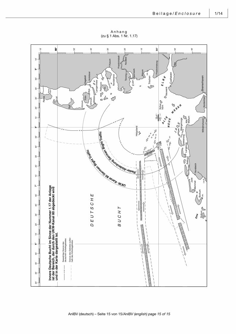
B e i l a g e / E n c l o s u r e 1/14
AnlBV (deutsch) – Seite 15 von 15/AnlBV (english) page 15 of 15
Pos: 17 /NfS/Beilagen/AnlBV/5. Deutsch Bucht Übersicht neu angelegt @ 0\mod_1384930040871_6.docx@ 3894 @ @ 1
A n h a n g(zu § 1 Abs. 1 Nr. 1.17)
=== Ende der Liste für Textmarke Inhalt ===
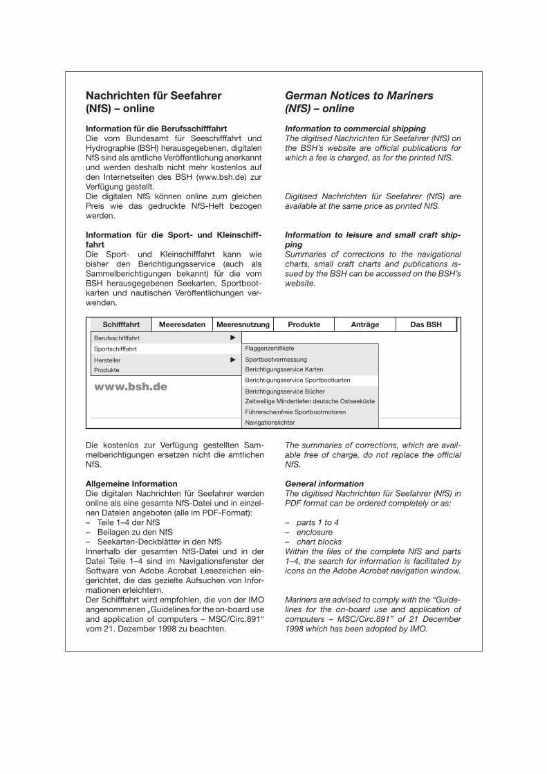
Nachrichten für Seefahrer
(NfS) – online
Information für die Berufsschifffahrt
Die vom Bundesamt für Seeschifffahrt und Hydrographie (BSH) herausgegebenen, digitalen NfS sind als amtliche Veröffentlichung anerkannt und werden deshalb nicht mehr kostenlos auf den Internetseiten des BSH (www.bsh.de) zur Verfügung gestellt.Die digitalen NfS können online zum gleichen Preis wie das gedruckte NfS-Heft bezogenwerden.
Information für die Sport- und Kleinschiff-
fahrt
Die Sport- und Kleinschifffahrt kann wie bisher den Berichtigungsservice (auch als Sammelberich tigungen bekannt) für die vom BSH herausgegebenen Seekarten, Sportboot-karten und nautischen Ver öffentlichungen ver-wenden.
German Notices to Mariners
(NfS) – online
Information to commercial shipping
The digitised Nachrichten für Seefahrer (NfS) on the BSH’s website are official publications for which a fee is charged, as for the printed NfS.
Digitised Nachrichten für Seefahrer (NfS) are available at the same price as printed NfS.
Information to leisure and small craft ship-
ping
Summaries of corrections to the navigational charts, small craft charts and publications is-sued by the BSH can be accessed on the BSH’s website.
Die kostenlos zur Verfügung gestellten Sam-melberichtigungen ersetzen nicht die amtlichen NfS.
Allgemeine Information
Die digitalen Nachrichten für Seefahrer werden online als eine gesamte NfS-Datei und in einzel-nen Dateien angeboten (alle im PDF-Format):– Teile 1–4 der NfS– Beilagen zu den NfS– Seekarten-Deckblätter in den NfSInnerhalb der gesamten NfS-Datei und in der Datei Teile 1–4 sind im Navigationsfenster der Software von Adobe Acrobat Lesezeichen ein-gerichtet, die das gezielte Aufsuchen von Infor-mationen erleichtern.Der Schifffahrt wird empfohlen, die von der IMO angenommenen „Guidelines for the on-board use and application of computers – MSC/Circ.891“ vom 21. Dezember 1998 zu beachten.
The summaries of corrections, which are avail-able free of charge, do not replace the official NfS.
General information
The digitised Nachrichten für Seefahrer (NfS) in PDF format can be ordered completely or as:
– parts 1 to 4– enclosure– chart blocksWithin the files of the complete NfS and parts 1–4, the search for information is facilitated by icons on the Adobe Acrobat navigation window.
Mariners are advised to comply with the “Guide-lines for the on-board use and application of computers – MSC/Circ.891” of 21 December 1998 which has been adopted by IMO.
Schifffahrt Meeresdaten Meeresnutzung Produkte Anträge Das BSH
Berufsschifffahrt c
Sportschifffahrt Flaggenzertifi kate
Hersteller c Sportbootvermessung
Produkte Berichtigungsservice Karten
www.bsh.deBerichtigungsservice Sportbootkarten
Berichtigungsservice Bücher
Zeitweilige Mindertiefen deutsche Ostseeküste
Führerscheinfreie Sportbootmotoren
Navigationslichter