Embed Size (px)
Citation preview
Proceedings World Geothermal Congress 2020
Reykjavik, Iceland, April 26 – May 2, 2020
1
Reservoir Rock of Ulubelu Geothermal System, Indonesia
Nusantara, V.D.M., Prasetyo, I.M., Pratama, G.R., Nurseto, S.T., Alibazah, J. S., Arifin, M.T., Koestono, H., and
Thamrin, M.H.
PT. Pertamina Geothermal Energy, Skyline Building 19th floor, Jl. MH. Thamrin No.9, Jakarta, 10340, Indonesia.
Keywords: Ulubelu, Borehole geology, Stratigraphy, Lithology, Reservoir, Well-targetting, Lateral permeability
ABSTRACT
Ulubelu geothermal field lays in a volcano-tectonic depression produced from combined Sula post-caldera depression and tectonism
related to the Great Sumatera Fault at 700 to 900 meter above sea level, Lampung, Indonesia. The field associated with a dormant
strato-volcanoe called Mt.Rendingan in the northern part, in which its pyroclastic products fills the graben structure to the southern
part. As a sequence of graben filling formation, the lithology distributed evenly inside the Ulubelu graben boundary. Drilling data
and well test result show a conformable trend between reservoir feed zone and Ignimbrite (Rhyolitic tuff) layer distribution as a
highly permeable zone.
With its unique pattern and characteristic, Ignimbrite layer is proven to be a productive reservoir zone controlled by both lithological
facies distribution and rock fracturing. Targeting this layer will improve the success ratio of production well in Ulubelu field. This
stratigraphic approach is effectively applied in volcano-tectonic depression setting filled by pyroclastic materials. With the same
regional tectonic setting, this lateral permeability concept might be suitable and relevant to be applied on other geothermal fields
along the great Sumatran fault.
1. INTRODUCTION
Ulubelu geothermal field located about 100 km west of Bandar Lampung, Lampung province, Sumatra Island, Indonesia. Pertamina
Geothermal Energy (PGE) conducted the exploration stage in Ulubelu since the late 80’s. The three first exploration slim holes were
drilled in 1995 with maximum borehole temperature of 225oC and depths averaging 900-1000 meter (Siahaan, 2015).
Ulubelu is a neutral liquid dominated geothermal system with 4x55 MWe installed capacity within 2018. The information about
Ulubelu geothermal field is shown in Table 1 and Table 2 below.
Table 1. Information of Ulubelu geothermal field
Ulubelu Geothermal Field 1st & 2nd Unit 3rd & 4th Unit
Commission 2012 2015
Energy sales contract Steam Electricity
Table 2. Character of Ulubelu geothermal system
Reservoir fluid Water dominated system.
Fluid pH Neutral.
Reservoir temperature 250 – 280 oC.
Heat source Mt. Rendingan.
Proven productive structure Northwest - Southeast trending structures inside the depression.
Ulubelu geothermal field lays as a half graben structures related to tensional stress from Great Sumatran Fault (GSF) inside the post-
caldera depression of Mt. Sula. GSF controls geological structures along Sumatran Island trending to northwest - southeast which is
perpendicular to subduction zone in the western part of Sumatra. The collapse structure produced from tensional stress controls
surface manifestations pathways in Ulubelu. Ulubelu productive structures identification was based on the interpretation from surface
structure alignments and also from borehole image data. Two main structures trending northwest - southeast defined as boundary of
hydrothermal distribution in the system. Pagar Alam fault restrains reservoir fluid pathways in the western, as well as Talang Marsum
fault in the eastern part of the depression (Trianggo, 2015).
The secondary fractures trending NW-SE and NNW-SSE inside the graben boundary is targeted as productive fault for production
well. This patterned fractures is proven as a feed zone associated with lateral permeability controlled by reservoir rock formation
facies. Targeting these fractures in reservoir rock layers will increase the permeability rate of production well in Ulubelu.
Nusantara et al.
2
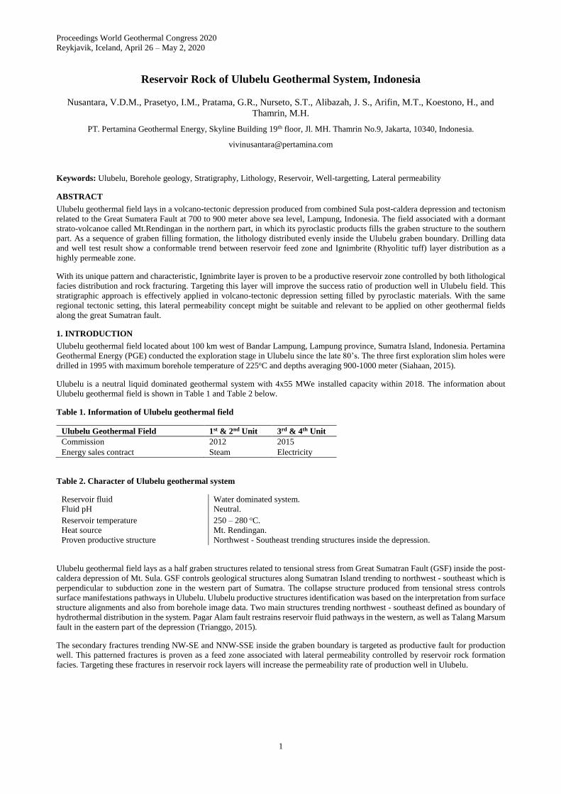
Figure 1: The figure of Ulubelu geothermal field from surface model and satellite image taken in early 2019 showing the
distribution of structures, manifestations, production - injection zone, and power plants location.
Ulubelu depression flanked by two young volcanoes, namely Mt. Rindingan and Mt. Tanggamus. With the diameters of 4 km, Ulubelu
depression mostly filled by young volcanic activity products and occurrence of monogenic volcanoes such as Mt. Duduk and Mt.
Tiga. Subsurface stratigraphy of Ulubelu geothermal field composed of lava and pyroclastic products of Mt.Rendingan, mixed
volcaniclastics breccia associated with carbonates lenses, ignimbrite as the reservoir facies of the system, and carbonaceous rocks as
the deepest layer penetrated by numerous wells at elevation around -1100 masl. The stratigraphy of Ulubelu geothermal system is
summarized in the table 3 below.
Table 3. Subsurface stratigraphy of Ulubelu geothermal system obtained from borehole data analysis
Stratigraphy
Facies
Rock Unit Elevation Character
Andesite Lava. Vesicular Andesite lava with
sheeting & columnar joint in
the surface. Porphyritic
texture, strongly oxidized.
Surface to 400 masl. This
depth interval is covered by a
cemented 20” blind casing.
Shallow loss zone with high mud loss rate,
secondary permeability caused by
fractured primary rock structures (sheeting
& columnar joints).
Pyroclastic
breccia. As
Claycap zone.
Tuff breccia, tuff lapilli,
andesite breccia. Associated
with carbonate lenses.
400 to (-500) masl. This
formation is thickening to the
east.
Typical high clay concentration (15-50%),
Washout sticky clay from rock matrix are
commonly causes bit balling problems.
Lenses of
Epiclasts and
Carbonates. As
Marker formation.
80% reworked skeletal
content (mudstone)
fragments in epiclast
breccia, matrix consist of
tuff and mud.
(-200) to (-500) masl. The
depth varies inside the
Pyroclastic breccia layer.
This interval covered by 13-
3/8” blind casing.
Rate of drilling mud loss 2-11 BPM. This
formation defined as a marker of transition
alteration zone in Ulubelu. Clay
concentration gradually decreasing from
50% to 10%.
Ignimbrite. As
Reservoir rock.
White colored fragmental
tuff with clear quartz, grain
supported. Described as
“clean tuff” or Rhyolitic tuff
facies as well. Washout
clays are disappeared.
(-500) to (-1100) masl. The
top of reservoir rock zone is
found to be tilted deeper to
the east. Production interval
secured by 10-3/4” liner.
Clay concentration drop significantly to
≤10%. Mud loss rate increasing gradually.
Stated as proven feed zones from PT-
spinner measurement data in several wells.
Carbonaceous
slate/rock. As
base of reservoir
zone.
Dark colored, consist of
carbonaceous rich clay
(Illite) to sand sized material
with micas. Vein filled by
wairakite. Shaly structure
and foliated, brittle, and
unstable.
(-1100) to (-1300) masl. The
bottom depth of the
formation is undefined due to
drilling problem. Shoe of 10-
3/4” or contingency 8-7/8”
perforated liner is set in this
depth as TD well.
Total loss circulation with aerated water
circulation,. Collapsed formation in this
interval is still unsolved by multiple
drilling scenario in total loss condition. It
causes high torque and stuck on drill pipe.
Nusantara et al.
3
As a sequence of graben filling formation inside of a depression system, the formation lateral distribution are spread evenly aligned
the basin topography. It is proven by borehole data in every well inside the depression that the dipping of this sequence of lithology
is tilted to east near Talang Marsum fault as the boundary.
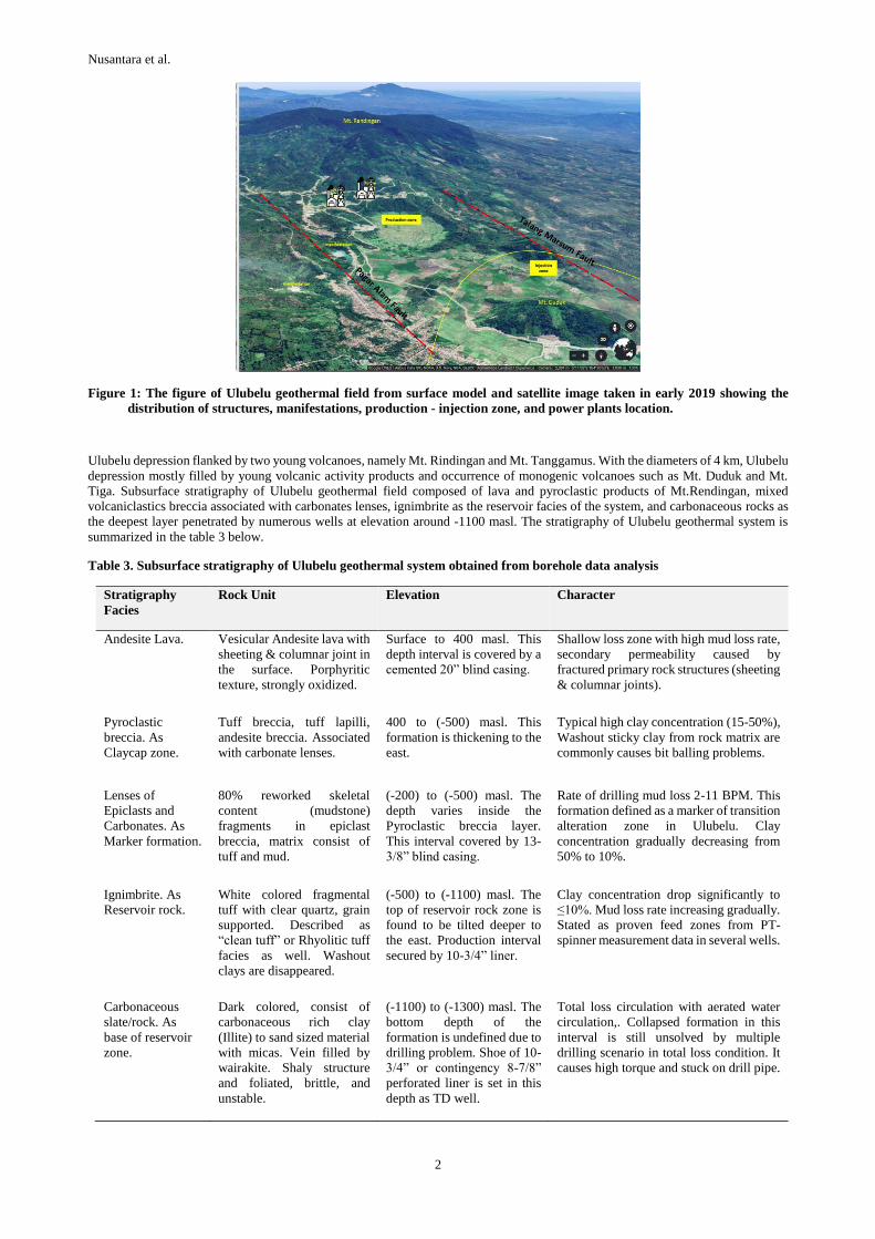
2. RESERVOIR ROCK FACIES
Petrography analysis of core and cutting samples determine the reservoir rock facies in Ulubelu as an altered Rhyolitic tuff facies by
its composition, or also called as Ignimbrite. It has fragmental texture, matrix supported, felsic color with vesicular structure filled
by secondary mineral. The Ignimbrite from core samples are fractured and jointed by later tectonic deformation.
Figure 2: Megascopic image of Ignimbrite in Ulubelu which is defined as a reservoir rock facies from core samples showing
the permeability features from secondary faults, microfractures, and its primary rock texture (vesicular) associated
with Epidote, Secondary Quartz, Pyrite, and Wairakite.
The ignimbrite consists of volcanic glass as ground mass, fine size plagioclase and primary quartz as phenocrist. Some glass shard
texture can be found in fully altered condition. Intensity of alteration in this facies is 0.6 IA or very intense. Ignimbrite is strongly
altered in groundmass and phenocrist to secondary minerals such as wairakite, illite, chlorite, carbonates, quartz epidote and opaque.
These secondary minerals also fill the vein and grain contact in rock body. Primary permeability in this lithology comes from its
microfractures, open veins, and vesiculars. Major composition of Ignimbrite in reservoir zone described at Table 4 below.
Table 4. Mineral composition of Ignimbrite in reservoir zone of Ulubelu geothermal system
Minerals Abundance by whole
rock percentage Remarks
Volcanic Glass 20% As altered groundmass with vesiculars, replaced by Chlorite & Illite.
Plagioclase
Primary Quartz
5%
5%
Phenocrist. Size 0.3-1 mm. subhedral, replaced by calcite and quartz.
Phenocrist. Size 0.1-2 mm, euhedral to anhedral.
Epidote 25% Sized 0.3-0.5 mm, suhedral-euhedral, replace groundmass, as vein, fills the pore.
Sec. Quartz 12% Fine grain size, replace the ground mass, as vein associated with epidote.
Calcite 13% Size 0.3-1 mm, replace the phenocrist, fills the veins and groundmass.
Opaque 7% Dispersed in groundmass and vein.
Illite 5% In groundmass, associated with chlorite and opaque.
Chlorite 5% Replace plagioclase and groundmass.
Wairakite 3% As veins associated with quartz and Opaque (pyrite).
Nusantara et al.
4
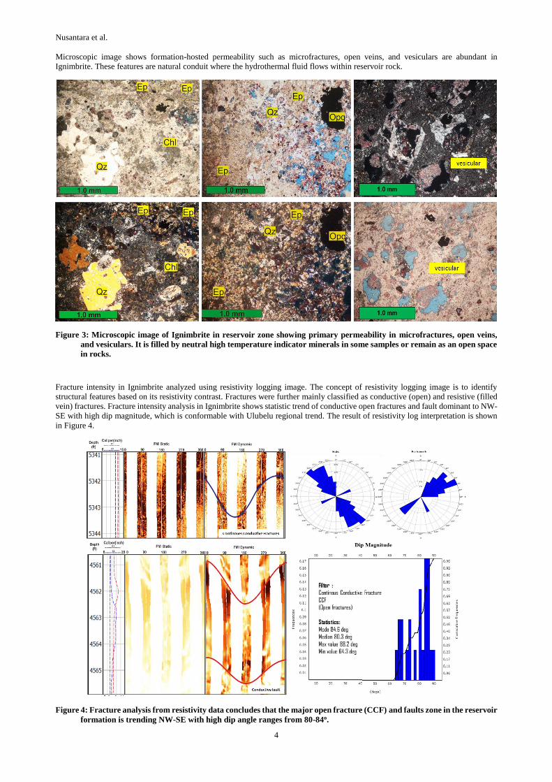
Microscopic image shows formation-hosted permeability such as microfractures, open veins, and vesiculars are abundant in
Ignimbrite. These features are natural conduit where the hydrothermal fluid flows within reservoir rock.
Figure 3: Microscopic image of Ignimbrite in reservoir zone showing primary permeability in microfractures, open veins,
and vesiculars. It is filled by neutral high temperature indicator minerals in some samples or remain as an open space
in rocks.
Fracture intensity in Ignimbrite analyzed using resistivity logging image. The concept of resistivity logging image is to identify
structural features based on its resistivity contrast. Fractures were further mainly classified as conductive (open) and resistive (filled
vein) fractures. Fracture intensity analysis in Ignimbrite shows statistic trend of conductive open fractures and fault dominant to NW-
SE with high dip magnitude, which is conformable with Ulubelu regional trend. The result of resistivity log interpretation is shown
in Figure 4.
Figure 4: Fracture analysis from resistivity data concludes that the major open fracture (CCF) and faults zone in the reservoir
formation is trending NW-SE with high dip angle ranges from 80-84o.
Nusantara et al.
5
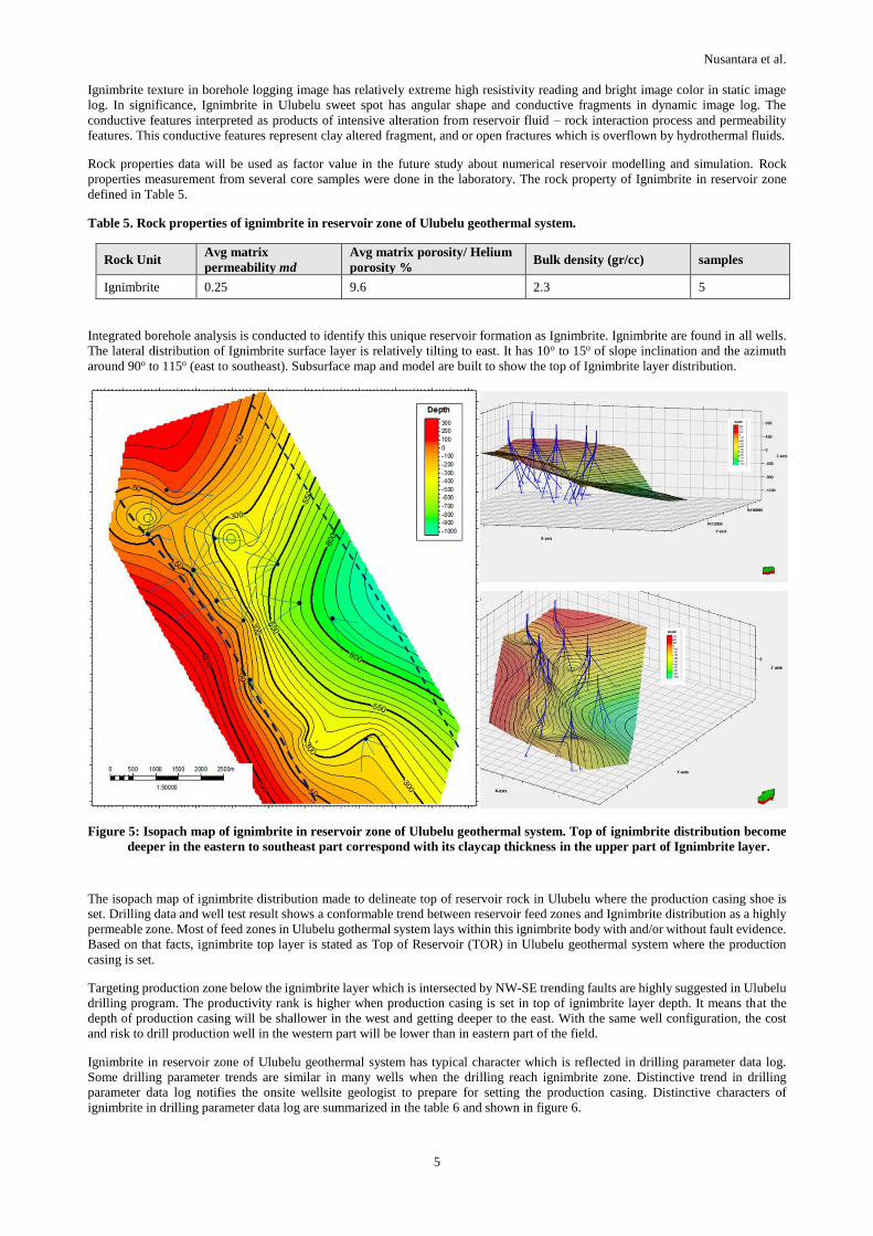
Ignimbrite texture in borehole logging image has relatively extreme high resistivity reading and bright image color in static image
log. In significance, Ignimbrite in Ulubelu sweet spot has angular shape and conductive fragments in dynamic image log. The
conductive features interpreted as products of intensive alteration from reservoir fluid – rock interaction process and permeability
features. This conductive features represent clay altered fragment, and or open fractures which is overflown by hydrothermal fluids.
Rock properties data will be used as factor value in the future study about numerical reservoir modelling and simulation. Rock
properties measurement from several core samples were done in the laboratory. The rock property of Ignimbrite in reservoir zone
defined in Table 5.
Table 5. Rock properties of ignimbrite in reservoir zone of Ulubelu geothermal system.
Rock Unit Avg matrix
permeability md
Avg matrix porosity/ Helium
porosity % Bulk density (gr/cc) samples
Ignimbrite 0.25 9.6 2.3 5
Integrated borehole analysis is conducted to identify this unique reservoir formation as Ignimbrite. Ignimbrite are found in all wells.
The lateral distribution of Ignimbrite surface layer is relatively tilting to east. It has 10o to 15o of slope inclination and the azimuth
around 90o to 115o (east to southeast). Subsurface map and model are built to show the top of Ignimbrite layer distribution.
Figure 5: Isopach map of ignimbrite in reservoir zone of Ulubelu geothermal system. Top of ignimbrite distribution become
deeper in the eastern to southeast part correspond with its claycap thickness in the upper part of Ignimbrite layer.
The isopach map of ignimbrite distribution made to delineate top of reservoir rock in Ulubelu where the production casing shoe is
set. Drilling data and well test result shows a conformable trend between reservoir feed zones and Ignimbrite distribution as a highly
permeable zone. Most of feed zones in Ulubelu gothermal system lays within this ignimbrite body with and/or without fault evidence.
Based on that facts, ignimbrite top layer is stated as Top of Reservoir (TOR) in Ulubelu geothermal system where the production
casing is set.
Targeting production zone below the ignimbrite layer which is intersected by NW-SE trending faults are highly suggested in Ulubelu
drilling program. The productivity rank is higher when production casing is set in top of ignimbrite layer depth. It means that the
depth of production casing will be shallower in the west and getting deeper to the east. With the same well configuration, the cost
and risk to drill production well in the western part will be lower than in eastern part of the field.
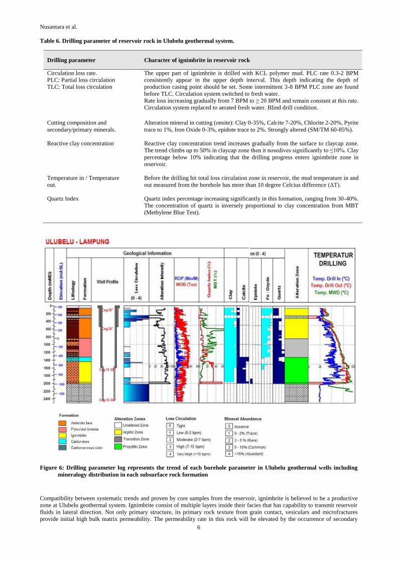
Ignimbrite in reservoir zone of Ulubelu geothermal system has typical character which is reflected in drilling parameter data log.
Some drilling parameter trends are similar in many wells when the drilling reach ignimbrite zone. Distinctive trend in drilling
parameter data log notifies the onsite wellsite geologist to prepare for setting the production casing. Distinctive characters of
ignimbrite in drilling parameter data log are summarized in the table 6 and shown in figure 6.
Nusantara et al.
6
Table 6. Drilling parameter of reservoir rock in Ulubelu geothermal system.
Drilling parameter Character of ignimbrite in reservoir rock
Circulation loss rate.
PLC: Partial loss circulation
TLC: Total loss circulation
The upper part of ignimbrite is drilled with KCL polymer mud. PLC rate 0.3-2 BPM
consistently appear in the upper depth interval. This depth indicating the depth of
production casing point should be set. Some intermittent 3-8 BPM PLC zone are found
before TLC. Circulation system switched to fresh water.
Rate loss increasing gradually from 7 BPM to ≥ 20 BPM and remain constant at this rate.
Circulation system replaced to aerated fresh water. Blind drill condition.
Cutting composition and
secondary/primary minerals.
Alteration mineral in cutting (onsite): Clay 0-35%, Calcite 7-20%, Chlorite 2-20%, Pyrite
trace to 1%, Iron Oxide 0-3%, epidote trace to 2%. Strongly altered (SM/TM 60-85%).
Reactive clay concentration Reactive clay concentration trend increases gradually from the surface to claycap zone.
The trend climbs up to 50% in claycap zone then it nosedives significantly to ≤10%. Clay
percentage below 10% indicating that the drilling progress enters ignimbrite zone in
reservoir.
Temperature in / Temperature
out.
Before the drilling hit total loss circulation zone in reservoir, the mud temperature in and
out measured from the borehole has more than 10 degree Celcius difference (ΔT).
Quartz Index Quartz index percentage increasing significantly in this formation, ranging from 30-40%.
The concentration of quartz is inversely proportional to clay concentration from MBT
(Methylene Blue Test).
Figure 6: Drilling parameter log represents the trend of each borehole parameter in Ulubelu geothermal wells including
mineralogy distribution in each subsurface rock formation
Compatibility between systematic trends and proven by core samples from the reservoir, ignimbrite is believed to be a productive
zone at Ulubelu geothermal system. Ignimbrite consist of multiple layers inside their facies that has capability to transmit reservoir
fluids in lateral direction. Not only primary structure, its primary rock texture from grain contact, vesiculars and microfractures
provide initial high bulk matrix permeability. The permeability rate in this rock will be elevated by the occurrence of secondary
Nusantara et al.
7
structures like open fractures near existing fault zone. For the next targeting in development well, it is highly recommended to consider
the ignimbrite distribution elevation combining with fractures/faults as drilling targets.
3. CONCLUSION
Lateral permeability controlled by reservoir rock in volcano – tectonic depression like Ulubelu is proven to be productive. The
subsurface distribution of the reservoir rock, in this case identified as ignimbrite lateral layer, should be mapped and modelled from
borehole data and taken into consideration to become target of geothermal well drilling.
The strategy of using combined lateral permeability and faults in depression system which is filled by volcanic rocks facies is
successfully applied for wells sitting and targeting in Ulubelu. It is elevate the drilling success ratio in the recent drilling campaign
from 2016 to 2018.
Preliminary geoscience study should be able to identify the regional tectonic volcano stratigraphy of a field and decide if this semi-
sedimentary lateral concept is suitable to be applied in one of the geothermal field in Sumatra depression (pull apart basin) region
such as Ulubelu. There is a high possibility that this lateral permeability concept might be suitable and relevant to be applied on other
geothermal fields along the great Sumatran fault which is produced by the same regional tensional stress like Ulubelu geothermal
system.
REFERENCES
Darma et.al.: Geothermal Energy Update: Geothermal Energy Development and Utilization in Indonesia, Proceedings, World
Geothermal Congress 2015, Melbourne, Australia (2015).
Hochstein et.al,: Indonesia Volcanic Geothermal System, Proceedings, World Geothermal Congress 2015, Melbourne, Australia
(2015).
Mulyadi : Ulubelu, The Most Developed Geothermal Area in South Sumatra, Proceedings, World Geothermal Congress 2000, Kyusu,
Japan (2000).
Nurseto et.al.: Evaluation of The Productive Geological Structure in Ulubelu Geothermal System, Proceedings, World Geothermal
Congress 2015, Melbourne, Australia (2015).
Siahaan E. E., Sasradipoera, Silitonga T. H., Pelmelay C., Koestono H., Mubarok M. H., and Rifki G.: Success Development Drilling
in Ulubelu Green Field in South Sumatra Based on Geological Structure Evidence, Generate 4X55MW, Proceedings, World
Geothermal Congress 2015, Melbourne, Australia (2015).
Yuniar, M., Hastuti P., and Silaban M.: Ulubelu, First Year Reservoir Monitoring, Proceedings, World Geothermal Congress 2015,
Melbourne, Australia (2015).