Embed Size (px)
Citation preview

Atti Soc. tosc. Sci. nat., Mem., Serie A, 112 (2007)pagg. 115-126, figg. 4, tab. 1
S. Sedov (*), e. Solleiro-rebolledo (*), S.l. Fedick (**), J. Gama-caStro (*),S. PalacioS-mayorGa (*), e. valleJo Gómez (*)
Soil geneSiS in relAtion to lAndScApe evolutionAnd Ancient SuStAinAble lAnd uSe in the northeAStern
YucAtAn peninSulA, Mexico
agrochimiche, tali da supporre che fosse usato come fertiliz-zante per compensare queste limitazioni.
Parole chiave - uso del territorio, evoluzione del paesaggio, suoli, Maya, Messico.
introduction
Maya civilization, perhaps the most developed pre-hispanic society of the Americas, flourished for over a thousand years in the tropical lowlands of south-ern Mexico and central America before declining for still unknown reasons around Ad 900 (Sharer, 1994). the high population levels of the region could only have been supported through intensive agriculture and resource management (culbert et al., 1990; Fedick, 1996). the Maya are one of the very few advanced agrarian civilizations to have developed in the humid tropics, within what is often considered to be a hostile and under productive environment. While there is great interest in the causes behind the classic Maya «col-lapse», an equally interesting problem is determining how very high population levels were maintained for hundreds of years without exhausting the thin and frag-ile soils that characterize the region.the main limitations for agriculture in the humid trop-ics are related to soil properties. in these ecosystems, most nutrient elements are contained in the plants. these nutrients are recycled quickly as vegetation dies, decom-poses, and the nutrients are made available again for plant uptake. this cycle is broken when vegetation is cleared for cultivation or other purposes. nutrients exit the system as crops are harvested, and shortening cycles of clearing and cultivation do not allow enough recycling of vegetation to replenish soil nutrients. land clearance also exposes the thin soils to heavy seasonal rains that can quickly lead to massive soil loss through erosion.Soil cover of the Yucatan peninsula, mainly classi-fied as Rendzinas (box lu’um in Yucatec Mayan) and Leptosols (tsek’el), are characterized as very shallow, humus rich, and stony. While many studies of ancient Maya intensive agricultural practices have now been conducted (harrison & turner, 1978; pohl, 1985; Flan-nery, 1982; Fedick, 1996; White, 1999), there has been relatively little research on how soil fertility was main-tained under such intensive cultivation systems.As a contribution to the study of ancient agricultural practices in the northern Maya lowlands, we assess the structure and properties of soils in order to understand
(*) departamento de edafología, instituto de geología, unAM, Mexico city, Mexico.(**) department of Anthropology, university of california, riverside, uSA.
Abstract - the ancient Maya developed productive agrosys-tems in a humid tropical environment often considered to have unfavorable soil conditions. our objective was to assess the pedogenetic and geomorphological processes which con-trol soil formation and distribution, as well as to understand their relation to landscape development and their influence in ancient agriculture. We studied a typical soil toposequence formed over limestone and affected by karst processes in the northeastern Yucatan peninsula. the soil cover is dominated by leptic phaeozems and rendzic leptosols in the uplands, and leptic calcisols in the wetlands. the soils of the uplands have a weathered groundmass containing abundant silicate clay and iron oxides; the intensive pedogenesis and vertical transport of soil material towards karst sinkholes is responsible of the thinness and high weathering status. in wetlands, bio-chemical calcite precipitation occurs, accompanied by surface accumulation of algal residues (periphyton crust). in the tran-sition area, a polygenetic profile (calcisol over cambisol) was developed, indicating recent advance of wetlands. the upland soils present limitations for agriculture: low p availability, and soil loss through karst erosion. periphyton has adequate agro-chemical properties to support the hypothesis that it was used as fertilizer for compensation of these constraints.
Key words - land management, landscape evolution, soils, Maya, Mexico.
Riassunto - Genesi del suolo in relazione all’evoluzione del paesaggio ed all’uso sostenibile del territorio nell’antichi-tà nella penisola dello Yucatan nord-orientale (Messico). gli antichi Maya svilupparono agrosistemi produttivi in un ambiente tropicale umido dove le caratteristiche dei suoli sono spesso considerate sfavorevoli. L’obiettivo di questo lavoro è individuare i processi pedologici e geomorfici che controllano la formazione e la distribuzione dei suoli e com-prendere le loro relazioni con l’evoluzione del paesaggio e la loro influenza sull’agricoltura antica. È stata studiata una tipi-ca toposequenza della penisola dello Yucatan nord-orientale, sviluppata su calcare ed influenzata da processi carsici. i suoli sono prevalentemente leptic phaeozems e rendzic leptosols nella zona collinare e leptic calcisols nelle aree paludose. i suoli di collina sono caratterizzati da una pasta di fondo alterata, contenente abbondanti argille silicatiche ed ossidi di ferro; la forte pedogenesi ed il trasporto di materiale verso gli inghiottitoi carsici sono causa del ridotto spessore e della forte alterazione. nelle zone umide di pianura si verifica la precipitazione biochimica di calcite assieme alla deposizione superficiale di residui algali (peryphyton crust). nella zona di transizione si sono sviluppati profili poligenici (calcisol su cambisol), indicando così un avanzamento recente delle zone paludose. I suoli di collina sono limitanti per l’agricoltura a causa della scarsa disponibilità di p e di forti perdite dovute all’erosione carsica. Il periphython ha buone caratteristiche

116 S. Sedov, e. Solleiro-rebolledo, S.l. Fedick, J. gAMA-cAStro, S. pAlAcioS-MAYorgA, e. vAlleJo góMez
their genesis, stability, and evolution. in particular, we investigate the possibility that the ancient Maya made use of a concentrated, high quality bio-fertilizer that was readily available in at least some areas of the northern lowlands. this potential source of nutrients is the algae mat, known as periphyton, that is known to grow in great abundance in wetlands of the Yalahau region, in the northeastern Yucatan peninsula. periphyton is a complex community of algae and other aquatic microorganisms that form in seasonal bodies of water such as wetlands (see Wetzel, 1983). We propose that the ancient Maya collected periphyton, and/or the nutrient-rich humus that forms beneath it, and transported these bio-fertilizers for use in home gardens and other agricultural plots.
environmental conditionS
our case study examines the soil cover distribution along a topographic transect (toposequence) in an area of northern Quintana roo, Mexico, where ongoing archaeological survey of the Yalahau regional human ecology project is documenting dense Maya settlement dating primarily to portions of the late preclassic and early classic periods (ca. 100 bc to Ad 350), with widespread reoccupation of the region dating to the late postclassic period (Ad 1250-1520) (see Fedick et al., 2000). the soil study focuses on land within and around the el eden ecological reserve, which is located 38
kilometers WNW of Cancun, Mexico (21° 3’N, 87°11’ W) (Fig. 1). geologically the northern peninsula consists of cretaceous age uplifted fossiliferous (primarily Acro-pora/diplora corals and mollusca bivalves) limestone. these rocks, mainly included in the Yucatan evaporite Formation (lópez-ramos, 1975), reach a depth of 3,500 m and rest over a paleozoic basement. overlying evap-orites, a sequence of limestones, sandstones and evapo-ritic deposits of paleocene-eocene age is found. the landscape is characterized as a relatively smooth plain broken by numerous karstic sinkholes (known locally as «cenotes»). the altitude of the platform averages 25-35 m (lugo-hupb et al., 1992). pool (1980) described (using Yucatec Mayan terminology) four geomorphic elements of the relief: heights or Ho’lu’um, plain or kan kab, depression or k’op, and cenotes or dzoonot.climate is hot and humid. Mean annual temperature is 25°c and the annual precipitation is 1,126 mm. the highest temperature, during May, is 28°c. the maxi-mum precipitation is concentrated in summer, from May to october, reaching 915 mm (garcía, 1988).natural vegetation is subtropical moist forest, a medi-um-high broadleaf, evergreen forest with Vitex gaumeri (yax nik) associated with Brosimum alicastrum (ramón), Bursera simaruba (chaka), Lysiloma bahamense (tzalam), and Coccoloba cozumelensis (boob) along with Guettarda compsii (tastab), Cedrella mexicana (cedro), and Lonchocarpus yucatensis (xuul) (Miranda, 1959). in wetlands, tropical savanna vegetation dominates.
Fig. 1 - location of study area and soil profiles.

117Soil geneSiS in relAtion to lAndScApe evolution And Ancient SuStAinAble lAnd uSe
methodS
Soils were defined according to their morphology following the criteria of the World reference base (Wrb, 1998). eighteen soil pits were opened, and for this study 7 were selected that represent different site conditions.bulk samples for physical and chemical analyses, as well as undisturbed samples for thin sections, were col-lected from genetic horizons. Soil colors were deter-mined according to the Munsell Soil color charts (1975). organic matter, available p and ph were evalu-ated according to guidelines of the united States depart-ment of Agriculture (uSdA, 1993). thin sections were prepared from undisturbed soil samples impregnated resin, studied under a petrographic microscope and described, following the terminology of bullock et al. (1985). elemental analysis of periphyton was carried out by pixe (particle induced x-ray emission).
reSultS
Soil distributionFigure 2 represents the distribution and variability of the most frequent soil associations, indicated by a conventional key, according to the uSdA (1993). this figure shows the presence of six soil associations, each of them consists of two or three soil units which gener-ally exhibit different properties. the first term of the key (lprz) points out that the soil unit represents more than 50% of the mapping unit. the last term of the key (lpli), indicates that this soil unit occupies at least 10% of the total area of this unit. there are also soils that occupy less than 10% of the surface. the most common association is rendzic leptosol + calcaric leptosol + lithic leptosol (lprz + lpca + lpli). differences in this association are due to changes in relief and lime-stone composition, expressed by calcaric leptosols + lithic leptosols (lpca + lpli). Areas with the least soil development are represented by lithic leptosols + rendzic leptosols (lpli + lprz). landforms under water saturation conditions are represented by the pres-ence of gleyic leptosols (lpgl), that are dominant in flood zones and wetlands. More detailed soil cover on the local scale shows also the presence of more devel-oped soils: leptic phaeozems and chromic cambisols in uplands and leptic calcisols in wetlands. however their sparse and patchy distribution makes it difficult to include them in the map which presents the soil cover assessment on a regional scale.the diverse soil units show a complex intergrade in genesis, evolution, distribution and differentiating char-acteristics. this intergradation probably has its origin in the different decarbonatation rates of the parent mate-rial (limestone), because of selective weathering. this intergradation also constitutes a three-dimensional con-tinuum of soils along which geographical boundaries are diffuse and consequently very difficult to draw, and sometimes impossible to separate through conventional soil survey.
Soil morphology and chemical characteristicsWe construct an e-W transect in order to identify soil variety and distribution through the landscape (Fig. 1 and pl. 4). Although the el edén area is characterized by the presence of a plain with little relief, two different landforms are found: the uplands and the wetlands.In the uplands (Ho’lu’um) under mainly undisturbed forest (profile 1), soils are thin (less than 30 cm depth), with an Ah/Ac/c profile. they have a dark reddish brown (5Yr 3/3, dry) Ah horizon, 15 cm thick (tab. 1). this horizon has a very well developed granular structure, with a high root density and a high content of organic carbon (8.9%, tab. 1). the Ac horizon is red-dish brown (5Yr 4/4, dry), with a fine granular struc-ture, and is softer than the previous horizon. Weathered limestone fragments are common, however, there is no reaction to hcl, indicating that soil matrix is free of
Fig. 2 - Soil association distribution in el edén area. Wi: wetland; dots: settlements; star: research station.
WRB (1998) FAO (1994)
Maya SoilClassification
lp: leptosol litosol chaltum
Tsek’el = LP + Rendzina
lprz:rendzic leptosol
rendzina Boxlu’um = Black Rendzina
K’ankab = Brown Rendzina
Chakl’um = Red Rendzina
lpli:lithic leptosol
litosol Chal tum - Tsek’el
lpgl:gleyic leptosol
litosol Ak’alche
lpca:calcaric leptosol
litosol Tsek’el

118 S. Sedov, e. Solleiro-rebolledo, S.l. Fedick, J. gAMA-cAStro, S. pAlAcioS-MAYorgA, e. vAlleJo góMez
carbonates. profile ph values are close to neutral (6.8). the c horizon is composed of 90% fractured limestone, in-filled by soil material. it was classified as leptic calcaric phaeozem. these soils are sometimes thinner (13 cm thick) and stony (profiles 2 and 3). the Ah horizon, with a less developed granular structure, rests directly on limestone. in this case, they were classified as rendzic leptosols.Within the relatively flat terrain, small depressions can be found (k’op). Within these depressions, soils are somewhat deeper and clayey. they show an A/bg/c profile (profile 4). the Ah horizon is very dark grayish brown (10Yr 3/2, dry), 11 cm thick, with a granular to subangular blocky structure and the highest content of organic carbon (15.3%). the bg horizon is grayish brown (10Yr 5/2, dry), clayey, with thin clay cutans over aggregates. bioturbation is strong and the pres-ence of Fe concretions is common. Some peds break into angular blocks with 60° angles, indicating ver-tic characteristics, although not very well expressed. Weathered limestone fragments are found at the depth of 24 cm, but horizons have no reaction to hcl. the soil was classified as leptic gleyic phaeozem.Another soil type was identified in the uplands, to the north-west side of the transect (Fig. 1). in this loca-tion, soils are thicker (35 cm-depth), and more clayey (profile 13). the surface o horizon (5 cm thick) can be subdivided into three layers. the first one is com-posed of fresh organic materials; the second one has partly decomposed organic matter, and the third is rich in fungi mycelium. the Ah horizon (15 cm thick) is dark reddish brown (5Yr 3/3, dry) and has a granular structure with a high root density and moderate con-
tents of organic carbon (5.2%, tab. 1). the b horizon, 15 cm thick, has a subangular blocky structure, is very hard when dry, and very clayey. the c horizon is rich in weathered limestone fragments, although the complete profile has no reaction to hcl, and has ph values of 6.5. it was classified as chromic cambisol.in uplands, the soil cover is discontinuous; rock out-crops are rather frequent and limestone looks strongly weathered, with dissolution pits and etched zones. Sur-prisingly, soils in some portions of the wetland are the thinnest in the whole area (profile 8). they are only a few centimeters thick, with 1 cm of a very dark gray (10Yr 3/1, dry) organic-matter horizon, highly decom-posed. under this thin soil profile we found a rather thin (less than 10 cm) gray bk horizon, rich in calcite and containing mollusk shells. it was classified as leptic calcisol.in intermediate positions, between uplands and the lower areas of wetland, where forest is restricted over gentle slopes, the periphyton appears, forming a soft crust (pl. 4). under periphyton, a 5-cm pale bk horizon was found with light gray color when dry (10Yr 7/1) that becomes brown when humid (7.5Yr 4/2). it is san-dy and rich in carbonates. below, a well developed soil profile was found. the buried A horizon is dark brown (7.5Yr 3/4, dry), 10 cm thick, with a well expressed granular structure and with abundant charcoal frag-ments. its organic carbon content is low (1.04%), and it does not react with hcl. the bw horizon, 10 cm thick, is similar in color (7.5Yr 3/4, dry), but coarser in texture (more silty), with abundant concretions and a slight reaction to hcl. the underlying c horizon has many weathered limestone fragments. this soil can be
tab. 1 - Selected properties of the study soils.
Horizon Depth (cm) Color dry Color wet OC* (%) pH P** ppm
profile 1leptic calcaric phaeozem
Ah 0-15 5Yr 3/3 5Yr 3/2 8.93 6.8 7.31
Ac 15-27 6.10 6.8 3.50
profile 2leptic calcaric phaeozem
Ah 0-13 5Yr 3/3 5Yr 3/2 9.15 6.8 10.10
profile 3rendzic leptosol
Ah 0-14 10Yr 3/2 10Yr 2/2 11.15 7.1 7.35
profile 4leptic gleyic phaeozem
Ah 0-11 10Yr 3/2 10Yr 2/2 15.3 6.3 7.31
bg 11-24 0.97 6.9 7.31
profile 13chromic cambisol
A 5-20 5Yr 3/3 5Yr 3/2 5.05 6.5 2.24
b 20-35 2.69 6.5 1.12
profile 5polygenetic profile
bk 0-5 7.5Yr 7/1 7.5Yr 4/2 2.59 7.5 7.31
Ah 5-14 7.5Yr 3/4 7.5Yr 3/2 1.04 7.6 3.50
bw 14-24 7.5Yr 3/4 7.5Yr 3/2 0.68 7.6 3.50
profile 8leptic calcisol
bk 1-3 5.20 7.5 3.01
* organic carbon. ** Available phosphorus.
119Soil geneSiS in relAtion to lAndScApe evolution And Ancient SuStAinAble lAnd uSe
regarded as polygenetic, because two different cycles of pedogenesis and sedimentation were recognized.in all geomorphological positions, including wetlands, we observed typical results of karstic alteration, forming fractures and sinkholes (cenotes of different sizes).
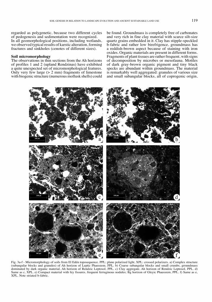
Soil micromorphologythe observations in thin sections from the Ah horizons of profiles 1 and 2 (upland rendzinas) have exhibited a quite unexpected set of micromorphological features. only very few large (> 2 mm) fragments of limestone with biogenic structure (numerous mollusk shells) could
be found. groundmass is completely free of carbonates and very rich in fine clay material with scarce silt-size quartz grains embedded in it. clay has stipple-speckled b-fabric and rather low birefrigence, groundmass has a reddish-brown aspect because of staining with iron oxides. organic materials are present in different forms. Fragments of plant tissues are rather frequent, with signs of decomposition by microbes or mesofauna. Mottles of dark gray-brown organic pigment and tiny black specks are abundant within groundmass. the material is remarkably well aggregated: granules of various size and small subangular blocks, all of coprogenic origin,
Fig. 3a-f - Micromorphology of soils from el edén toposequence. ppl: plane polarized light, xpl: crossed polarizers. a) complex structure (subangular blocks and granules) of Ah horizon of leptic phaeozem, ppl. b) coarse subangular blocks and small crumbs, groundmass dominated by dark organic material, Ah horizon of rendzic leptosol, ppl. c) clay aggregate, Ah horizon of rendzic leptosol, ppl. d) Same as c, xpl. e) compact material with fey fissures, frequent ferruginous nodules; bg horizon of gleyic phaeozem, ppl. f) Same as e, xpl. note striated b-fabric.

120 S. Sedov, e. Solleiro-rebolledo, S.l. Fedick, J. gAMA-cAStro, S. pAlAcioS-MAYorgA, e. vAlleJo góMez
are partly welded, to form the porous aggregates of higher order, and all together produce spongy fabric with a dense void system (Fig. 3a).despite the macromorphological similarity with lep-tic phaeozems, the micromorphological properties of rendzic leptosols are quite different. groundmass is mainly formed by dark-colored (brown or black) iso-tropic organic material. under higher magnification, a large part is dominated by fine detritus. larger frag-ments of plant tissues in different stages of decompo-sition are also abundant. this material is organized in
rather coarse subangular blocks or in small crumbs of irregular shape (Fig. 3b). in contrast to phaeozems, carbonate particles of various sizes (from gravel to tiny micrite specks) are frequent in the groundmass. Although the major part of these particles are derived from the physical breakdown of limestone, there is also some neoformed biogenic calcite – presumably a root metabolism product. on the contrary, all kinds of silicate materials, and in particular clay, are scarce. We found only few clay-rich rounded aggregates with lighter yellow-brown color and speckled to granostri-
Fig. 3g-l - Micromorphology of soils from el edén toposequence. ppl: plane polarized light, xpl: crossed polarizers. g) Stress cutan, bg horizon of gleyic phaeozem, xpl. h) charcoal fragments, bg horizon of gleyic phaeozem, ppl. i) channeled micritic aggregate, bk horizon, leptic calcisol, ppl. j) Same as i, xpl. k) Micritic ooids, bk horizon, leptic calcisol, ppl. l) Mollusk shell, bk horizon, leptic calcisol, ppl.
121Soil geneSiS in relAtion to lAndScApe evolution And Ancient SuStAinAble lAnd uSe
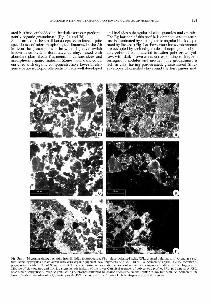
ated b-fabric, embedded in the dark isotropic predomi-nantly organic groundmass (Fig. 3c and 3d).Soils formed in the small karst depression have a quite specific set of micromorphological features. in the Ah horizon the groundmass is brown to light yellowish brown in color. it is dominated by clay, mixed with abundant plant tissue fragments of various sizes and amorphous organic material. zones with dark color, enriched with organic components, have lower birefri-gence or are isotropic. Microstructure is well developed
and includes subangular blocks, granules and crumbs. the bg horizon of this profile is compact, and its struc-ture is dominated by subangular to angular blocks sepa-rated by fissures (Fig. 3e). Few, more loose, microzones are occupied by welded granules of coprogenic origin. the color of soil material is rather pale brown-yel-low, with dark-brown areas corresponding to frequent ferruginous nodules and mottles. the groundmass is rich in clay, having porostriated, granostriated (thick envelopes of oriented clay round the ferruginous nod-
Fig. 3m-r - Micromorphology of soils from el edén toposequence. ppl: plane polarized light, xpl: crossed polarizers. m) granular struc-ture, some aggregates are coloured with dark organic pigment, few fragments of plant tissues. bk horizon of upper calcisol member of polygenetic profile, ppl. n) Same as m, xpl, note intensive interferention colours of micrite, dark aggregates show low birefrigence. o) Mixture of clay-organic and micritic granules, Ah horizon of the lower cambisol member of polygenetic profile, ppl. p) Same as o, xpl, note high birefrigence of micritic granules. q) Microarea cemented by coarse crystalline calcite (center to low left part), Ah horizon of the lower cambisol member of polygenetic profile, ppl. r) Same as q, xpl, note high birefrigence of calcitic cement.
122 S. Sedov, e. Solleiro-rebolledo, S.l. Fedick, J. gAMA-cAStro, S. pAlAcioS-MAYorgA, e. vAlleJo góMez
ules) and mosaic-speckled b-fabric (Fig. 3f). rather frequent are stress cutans along opened and closed fis-sures (Fig. 3g). Few charcoal fragments are embedded in the groundmass (Fig. 3h). Soil material is free of carbonates in both in the Ah and bg horizons.the micromorphology of the leptic calcisol in the wetland implies a quite distinct mode of pedogenesis. the major part of groundmass consists of carbonates – in contrast to highland phaeozems and cambisols, in which groundmass is dominated by silicate clay. however, these carbonates are represented not by fragmented parent limestone (as in rendzic leptosol) but exclusively by neoformed micritic calcite. Micrite (with admixture of microsparite) forms blocky and granular aggregates, often welded to build up spongy fabric with high porosity. Frequently the micrite accu-mulations have specific biogenic microstructure: ooids (Fig. 3k), channeled clusters, related to the activity of algae (Fig. 3i, j) (vogt, 1987). granules are often colored with dark-brown organic pigment – the pres-ence of which lowers the material birefrigence. partly decomposed plant tissues as well as shell fragments, or even complete unbroken shells (Fig. 3l) of mollusks are common.Soils on the gentle slope towards the wetland (profile 5) demonstrate a peculiar and contradictory combina-tion of micromorphological properties; according to earlier observations, some of them are typical for the wetland and others, for the upland soils. the surface carbonate horizon is an analogue of laguna calcisols; its material is dominated by neoformed biogenic cal-cite (Fig. 3m, n). on the contrary, the underlying Ah and bw horizons resemble the phaeozems of elevated landsurfaces: their groundmass is free of carbonates and contains abundant silicate clay. the Ah horizon has a granular structure and is enriched with organic material; however it also has some clusters of biogenic micrite that may be derived from the overlying car-bonate horizon (Fig. 3o, p). the micromorphology of bw is somewhat similar to the bg horizon of the karst depression phaeozem, being rather compact, clayey, having blocky structure and containing frequent fer-ruginous nodules. however, its groundmass has darker color due to pigmentation with iron oxide, the clay is less oriented, and stress cutans are absent. A peculiar feature observed in thin sections from both Ah and bw horizons are microzones, cemented by large crystals of calcite, filling all available pore space and «trapping» the soil aggregates (Fig. 3q, r).
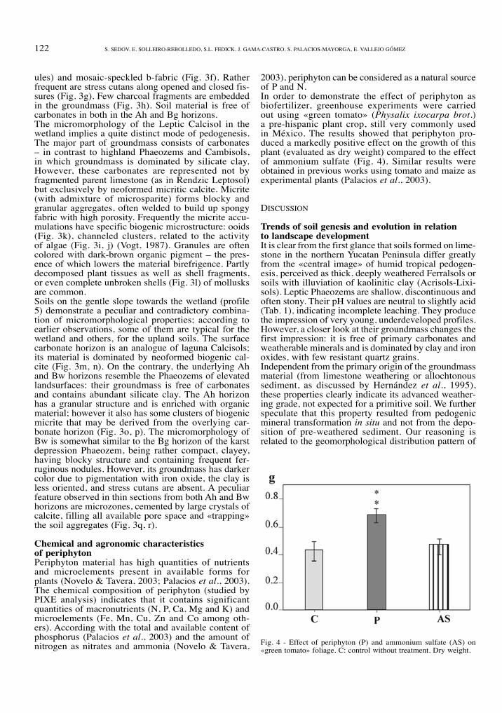
Chemical and agronomic characteristics of periphytonperiphyton material has high quantities of nutrients and microelements present in available forms for plants (novelo & tavera, 2003; palacios et al., 2003). the chemical composition of periphyton (studied by pixe analysis) indicates that it contains significant quantities of macronutrients (n, p, ca, Mg and k) and microelements (Fe, Mn, cu, zn and co among oth-ers). According with the total and available content of phosphorus (palacios et al., 2003) and the amount of nitrogen as nitrates and ammonia (novelo & tavera,
2003), periphyton can be considered as a natural source of p and n.in order to demonstrate the effect of periphyton as biofertilizer, greenhouse experiments were carried out using «green tomato» (Physalix ixocarpa brot.) a pre-hispanic plant crop, still very commonly used in México. the results showed that periphyton pro-duced a markedly positive effect on the growth of this plant (evaluated as dry weight) compared to the effect of ammonium sulfate (Fig. 4). Similar results were obtained in previous works using tomato and maize as experimental plants (palacios et al., 2003).
diScuSSion
Trends of soil genesis and evolution in relationto landscape developmentit is clear from the first glance that soils formed on lime-stone in the northern Yucatan peninsula differ greatly from the «central image» of humid tropical pedogen-esis, perceived as thick, deeply weathered Ferralsols or soils with illuviation of kaolinitic clay (Acrisols-lixi-sols). leptic phaeozems are shallow, discontinuous and often stony. their ph values are neutral to slightly acid (tab. 1), indicating incomplete leaching. they produce the impression of very young, underdeveloped profiles. however, a closer look at their groundmass changes the first impression: it is free of primary carbonates and weatherable minerals and is dominated by clay and iron oxides, with few resistant quartz grains.independent from the primary origin of the groundmass material (from limestone weathering or allochtonous sediment, as discussed by hernández et al., 1995), these properties clearly indicate its advanced weather-ing grade, not expected for a primitive soil. We further speculate that this property resulted from pedogenic mineral transformation in situ and not from the depo-sition of pre-weathered sediment. our reasoning is related to the geomorphological distribution pattern of
Fig. 4 - effect of periphyton (p) and ammonium sulfate (AS) on «green tomato» foliage. c: control without treatment. dry weight.

123Soil geneSiS in relAtion to lAndScApe evolution And Ancient SuStAinAble lAnd uSe
weathering products. the most altered soil materials were found on elevated land surfaces which provide a leaching environment of accelerating weathering, and not in lower wetlands, which present better con-ditions for accumulation of any kind of sediment but less opportunities for advanced in situ mineral altera-tion because of poor internal drainage. As an additional argument in favor of the possibility for advanced in situ weathering in Yucatan, we should mention its rather long persistence as a stable terrestrial block, since the tertiary.We arrived at what seems to be a contradiction between high weathering status of soil materials from one side and its thinness, uneven distribution, and abrupt con-tact with the limestone from the other. the interac-tion of pedogenetic and geomorphological processes is supposed to be responsible for such a situation. in general, we believe that considerable soil redeposition occurs permanently in geomorphologically unstable karst environments of the northern Yucatan peninsula. however, our studies of the soil catenary sequence at el edén revealed no signs of lateral sheet erosion, natu-ral or man-induced, which would transport fine mate-rial from the uplands to the wetlands. in the latter we have not found thick pedosediments: wetland profiles are often thinner than upland ones. the evidence, even more convincing, is that the groundmass composition of wetland calcisols is very specific and cannot result from redeposition of materials, originating either from upland phaeozems or from limestone. calcisols lack the silicate clay, which could serve as a marker of phaeozem-derived pedosediments. their groundmass consists mostly of carbonates; however, those are not the products of limestone fragmentation, but the result of biochemical calcite precipitation from dissolved car-bonates, mostly by algae. We relate this process directly to the functioning of algal community developed in wetlands during rainy season, which forms the periphy-ton. this conclusion agrees with results reported by leyden and co-workers (1996). these authors also found low erosion rates and absence of anthropogenic lateral soil transport enhancement.the erosional dynamics in the northern Maya low-lands seems to differ remarkably from that in the south-ern Maya lowlands, where various authors report the strongest evidences of intensive lateral soil transport corresponding to ancient Maya occupation periods. evidence for erosion in the southern lowlands includes thick layers of redeposited soil on lower land surfaces (beach, 1998a; beach et al., 2003; dunning et al., 2002) as well as enhanced sediment accumulation in lakes (summarized by rice, 1996). both phenomena are lacking in our study area. We agree with leyden et al. (1996) that this difference is related to the character of relief. however, although we did not find evidence of long distance lateral soil redeposition we assume that short-distance, mostly vertical soil transport is quite intensive towards cracks, hollows, and small but steep depressions of karst origin. We found a lot of such forms, empty as well as partly filled with fine pedosediments in all parts of our toposequence. Adja-cent to these karstic forms, limestone outcrops are often
free of soil. the phaeozem in the small karst depression described earlier has enhanced thickness, due to addi-tion of redeposited soil from above, as indicated by the presence of charcoal fragments even in its lowest bg horizon. As far as many karst sinkholes are connected to a vast underground system, part of the soil material is probably transported deeper, contributing to cave and cenote sediments. in fact, each profile on the land surface is the result of a balance between pedogenesis (leaching and weathering, as well as clay, iron oxide and humus accumulation in the uplands; secondary car-bonate precipitation and surface accumulation of plant debris and periphyton crust in the wetlands) and soil loss due to vertical transportation towards karst sink-holes. rate differences between these two processes (as far as karst erosion is highly variable) cause the variety of in situ soils: from thick red chromic cambisols to the thinnest rendzic leptosols, and finally bare etched rock. it should be noted that the groundmass of ren-dzic leptosols, although dominated by plant detritus and primary carbonates, still contains some clay-rich aggregates – most probably the last remnants of an earlier continuously weathered horizon, like that in the neighboring phaeozems. We suppose that these lepto-sols are not young soils in its early stage of formation, but rather a result of degradation of a previous well developed profile, due to unbalanced soil loss caused by enhanced karst erosion.in the minute pedosediment accumulation depressions, the highest soil thickness is accompanied by the mani-festation of redoximorphic processes (frequent ferru-ginous nodules) indicating that these locations receive both additional fine material and moisture. only here we found profiles with vertic properties, which are reported to be much more common in depressions of the southern Maya lowlands (beach et al., 2003). When small karst sinkholes or fissures are filled with pedosediment, they may be interpreted as representing a rather deep, vertically oriented A horizon associated with the adjacent rock outcrops.Similar «balance» models for soil cover development in karst regions were proposed for other natural zones such as boreal forests (goryachkin & Shavrina, 1997) and Mediterranean environments (Atalay, 1997).
Two-storeyed soil in the wetland periphery:an indicator of recent environmental changeA soil profile formed in the marginal part of the wet-land, close to the upland forest has signs of the over-lapping of two different pedogenetic events. the upper unit, similar to wetland calcisol, is superimposed on a cambisol, which is typical for upland soil formation. We interpret it as a result of the extension of wetland area, affected by the regular floods towards the terri-tories earlier occupied by the upland forest ecosystem. We also attribute partial cementation of the cambisol groundmass (originally carbonate-free) by large crystals of secondary calcite to the same landscape dynamics, which caused periodical saturation of soil with surface water, from which calcium carbonate could precipitate. the timing of this environmental change is unknown, as far as no instrumental or archaeological dating for
124 S. Sedov, e. Solleiro-rebolledo, S.l. Fedick, J. gAMA-cAStro, S. pAlAcioS-MAYorgA, e. vAlleJo góMez
either of the two soil units are available. the driving force of this dynamic is also uncertain and could imply climatic change as well as groundwater table rising, related to sea level fluctuations. the data on the stratig-raphy of paleosol-sedimentary sequences of the south-ern Maya lowlands give some hints for the preliminary correlation and interpretation of our calcisol-cambi-sol profile. in a number of papers where such data are presented (pohl & bloom, 1996; pope & pohl, 1996; voorhies, 1996), the following stratification regularity is described: well developed humus-rich paleosols are overlain by pale «gray clay», or «gray silt», often with carbonates and gypsum, sometimes accompanied by layers of freshwater mollusk shells. the lower paleosols indicate a phase of relative geomorphological stability, while the overlying layers «are the result of natural deposition representing both alluviation and colluvia-tion in floodplains and associated backswamps, accen-tuated by deposition of calcium carbonate and gypsum from ground and surface water» (pohl & bloom, 1996). We suppose that the cambisol unit (profile 5) could be correlative to organic-rich paleosols and the calcisol, the overlying carbonate-rich sediments; so if our cor-relation is right, the two-storeyed profile of the wet-land periphery reflects landscape processes which took place within the ancient Maya occupation period.
Pedogenetic properties in relation to ancientland useFray diego de landa, a Franciscan missionary who arrived to Yucatan soon after the Spanish occupation and left informative descriptions about various aspects of Maya life wrote: «Yucatan is the country with the least earth that i have seen… it is marvelous that the fertility of this land is so great on top of and between the stones» (tozzer, 1941: 186, original 1566). in this passage he refers to the extraordinary fertility of thin calcareous soils of Yucatan (leptic phaeozems and rendzic leptosols described above) which, from the contemporary standpoint, seem to be so unsuited to agriculture. in fact, these soils lack the majority of dis-advantages common to the usual, extremely leached, humid tropical soils. the characteristics of Yucatan soil are provided by the unique combination of weathered groundmass, rich in silicate clay and iron oxides, and limestone located quite near the surface. the permanent dissolution of the latter (evidenced by various corrosion forms) gives sufficient dissolved calcium carbonate to provide ph values close to neutral and to avoid the problems of typical tropical soils, related to excessive acidity and Al toxicity. it also provides the stabilization and high accumulation of dark disperse humus. humus, clay, and iron oxides are the agents of stable aggregate formation which provide favorable physical properties, regarding soil moisture availability, aeration, and root penetration. there is no tendency to compaction and hardening, that is usual for cultivated tropical Acrisols and lixisols (van Wambeke, 1992). We agree with beach (1998b) that the major soil limitations for agri-
culture are its thinness and uneven surface distribu-tion, as well as very low available p contents (tab. 1), showing deficiency in this nutrient. An important way to match cultivation to such soil conditions, was plant-ing in natural karst features filled with soil material (kepecs & boucher, 1996).
Wetlands: a source of fertilizer for upland soils?recent studies in the southern Maya lowlands have produced evidence for ancient manipulation and trans-formation of wetlands for intensive agricultural produc-tion (e.g. turner & harrison, 1983; culbert et al., 1990; pohl & bloom, 1996). this evidence comes primarily from wetlands with thick, dark, humus-rich paleosols that overlay even deeper deposits of clayey sediments. in some cases the ancient Maya apparently manipulated natural hummocks in these wetlands for cultivation, in other cases they excavated channels to improve drain-age, and in some wetlands they may have constructed raised planting platforms. none of these practices are apparent, nor were they probably possible, in the wet-lands of the Yalahau region in the northeastern Yucatan peninsula, where the studied calcisols directly overlay bedrock. however, an extensive system of rock-align-ment features, apparently constructed by the ancient Maya, has been documented in the el edén wetland, and similar features have been noted in other wetlands of the region (Fedick, 2003; Fedick et al., 2000). While the catena presented in this study suggests poor agri-cultural potential for the shallow wetland calcisols, it should be remembered that hydraulic conditions and soil formation processes in the wetlands may have var-ied considerably through the holocene, as suggested by recent studies of climate change and sea level fluc-tuations (curtis et al., 1996; Froede, 2002; haug et al., 2003; Morton et al., 2000). our own soil studies indicate that the extent of the Yalahau wetlands, and the associated soil formation processes, have changed through recent geological time. it should also be noted that the current catena does not include deeper soils known to exist within the el edén wetland. the record-ed rock alignment features ring the deeper marshes and savannas, and form check-dams across the sloughs (Fedick et al., 2000). Fedick (2003) has suggested a number of possible wetland plant and animal resources (rather than domesticated crops) that may have been cultivated by the Maya through the control of soil and water movement within the wetlands. the possibility that wetland hydrology may have been manipulated to encourage the growth of periphyton remains a viable hypothesis. preliminary studies by Morrison & cózatl (2003) have recovered aquatic (wetland) species of mollusks from an ancient upland habitation site and probable gardening area, strongly suggesting the trans-port of periphyton or wetland soils for use as fertilizer. our ongoing soils and archaeological studies seek to clarify both the ancient use of wetlands as possible cul-tivation areas, and possible transport of periphyton or wetland soils for upland gardening.
125Soil geneSiS in relAtion to lAndScApe evolution And Ancient SuStAinAble lAnd uSe
acknowledGementS
this research has been funded by uc MexuS - conAcYt collabo-rative grant program 2002 («reconstructing ancient Maya sustainable intensive agriculture: a multidisciplinary evaluation of the periphyton fertilizer hypothesis»). We thank Juan castillo-rivero and James rotenberg for their valuable guidance during field research in el edén, and to l. huerta-Arcos and e. Jiménez for technical assistance.
reFerenceS
Atalay i., 1997. red Mediterranean soils in some karstic regions of taurus mountains, turkey. Catena 28: 247-260.
beach t., 1998a. Soil catenas, tropical deforestation, and ancient and contemporary soil erosion in the petén, guatemala. Phys. Geogr. 19: 378-405.
beach t., 1998b. Soil constraints on northwest Yucatan, México: pedoarchaeology and Maya subsistence at chunchucmil. Geoar-chaeology 13: 759-791.
beach t., dunning n., luzzadder-beach S., Scarborough v., 2003. depression soils in the lowland tropics of northwestern belize: anthropogenic and natural origins. in: gómez-pompa A., Allen M., Fedick, S., Jiménez-orsonio J. (eds.), the lowland Maya Area: three Millennia at the human-Wildland interface: 139-174. haworth press, binghampton, nY.
bullock p., Fedoroff n., Jongerius A., Stoops g., tursina t., babel u., 1985. handbook for Soil thin Section description. Waine research publications, Wolverhampton, u.k.
culbert t.p, rice d.S. (eds.), 1990. prehistoric population history in the Maya lowlands. university of new Mexico press, Albuquer-que.
curtis J.h., hodell d.A., brenner M., 1996. climate variability on the Yucatan peninsula (Mexico) during the past 3500 years, and the implications for Maya cultural development. Quaternary Res. 46: 37-47.
dunning n.p., luzzadder-beach S., beach t., Jones J.g., Scarborou-gh v., culbert t.p., 2002. Arising from the bajos: the evolution of a neotropical landscape and the rise of Maya civilization. Ann. Assoc. Am. Geogr. 92: 267-283.
Fedick S.l. (ed.), 1996. the managed mosaic: ancient Maya agricul-ture and resource use. university of utah press, Salt lake city.
Fedick S.l., Morrison b.l., Andersen b.J., boucher S., ceja Aco-sta J., Mathews J.p., 2000. Wetland manipulation in the Yalahau region of the northern Maya lowlands. Journal of Field Archaeo-logy 27: 131-152.
Fedick S.l., 2003. Archaeological evidence for ancient and historic resource use associated with the el edén wetland, northern Quin-tana roo, Mexico. in: gómez-pompa A., Allen M.F., Fedick S.l., Jiménez-osornio J.J. (eds.), the lowland Maya area: three mil-lennia at the human-wildland interface: 339-359. haworth press, binghamton, newYork.
Flannery k.v. (ed.), 1982. Ancient Maya subsistence: studies in memory of dennis e. puleston. Academic press, new York.
Froede c.r.J., 2002. rizolith evidence in support of a late holoce-ne sea-level highstand at least 0.5 m higher than present at key biscayne, Florida. Geological Survey of America 30: 203-206.
harrison p.d., turner ii b.l. (eds.), 1978. pre-hispanic Maya agri-culture. university of new Mexico press, Albuquerque.
haug g.h., günter d., peterson l.c., Sigman d.M., hughen k.A., Aeschlimann b., 2003. climate and the collapse of Maya civili-zation. Science 299: 1731-1735.
hernández x.e., bello b.e., levy t.S., 1985. la roza-tumba-quema en Yucatán. in: la milpa en Yucatán: un sistema de producción agrícola tradicional: 35-86, colegio de postgraduados, Monte-cillo, México.
garcía e., 1988. Modificaciones al sistema de clasificación climática de köpen (special edition made by author).
goryachkin S.v., Shavrina e.v., 1997. evolution and dynamics of soil-geomorphic systems in karst landscapes of the european nor-th. Eurasian Soil Sci. 30: 1045-1055.
kepecs S., boucher S., 1996. the pre-hispanic cultivation of rejol-ladas and stone-lands: new evidence from northeast Yucatan. in:
Fedick S.l. (ed.), the managed mosaic: ancient Maya agricul-ture and resource use: 69-91. university of utah press, Salt lake city.
leyden b.W., brenner M., Whitmore t., curtis J.h., piperno d.r., dahling b.h., 1996. A record of long- and short-term climatic variation from northwest Yucatan: cenote San José chulchacá. in: Fedick S.l. (ed.), the managed mosaic: ancient maya agri-culture and resource use: 30-50. university of utah press, Salt lake city.
lópez-ramos A., 1975. geología general y de México. 1ª edición, tomo iii, 446, México.
lugo-hubp J., Aceves-Quezada J., espinasa-pereña r., 1992. rasgos geomorfológicos mayores de la península de Yucatán. revista del instituto de geografía, UNAM 10: 143-150.
Miranda F., 1959. estudios acerca de la vegetación. in: beltrán e. (ed.), los recursos naturales del sureste y su aprovechamiento. instituto Mexicano de recursos naturales renovables, México, 2: 251-271.
Morton r.A., paine J.g., blum M.d., 2000. responses of stable bay-margin and barrier-island systems to holocene sea-level high-stands, western gulf of Mexico. J. Sediment. Res. 70: 478-490.
Munsell Soil color charts, 1975. Macbeth division of kollmorgen corporation, baltimore, Maryland.
novelo e., tavera r., 2003. the role of periphyton in the regulation and supply of nutrients in a wetland at el eden, Quintana roo. in: gómez-pompa A., Allen M., Fedick, S., Jiménez-orsonio J.J. (eds.), the lowland Maya area: three millennia at the human-wildland interface. binghampton, nY, haworth press.
palacios S., Anaya A.l., gonzález-velásquez e., huerta-Arcos l., gómez-pompa A., 2003. periphyton as potential biofertilizer in intensive agriculture of the ancient Maya. in: gómez-pompa A., Allen M., Fedick S.l., Jiménez-orsonio J.J. (eds.), the lowland Maya area: three millennia at the human-wildland interface. bing-hampton, nY, haworth press.
pohl M. (ed.), 1985. prehistoric lowland Maya environment and sub-sistence economy. papers of the peabody Museum of Archaeol-ogy and ethnology, vol. 77. harvard university, cambridge.
pohl M., bloom p., 1996. prehistoric Maya farming in the wetlands of northern belize: more data from Albion island and beyond. in: Fedick S.l. (ed.), the managed mosaic: ancient Maya agri-culture and resource use: 145-164. university of utah press, Salt lake city.
pool l., 1980. el estudio de los suelos calcimórficos con relación a la producción maicera. in: hernández x.e., padilla r.o. (eds.), Seminario sobre producción agrícola en Yucatán: 13-18. gob. del estado de Yucatán,-SArh-Spp-cp Mérida, Yucatán, México.
pope k.o., pohl M.d., 1996. Formation of ancient Maya wetland fields: natural and anthropogenic processes. in: Fedick S.l. (ed.), the managed mosaic: ancient Maya agriculture and resource use: 165-176, university of utah press, Salt lake city.
rice d.S., 1996. paleolimnological analysis in the central petén, guatemala. in: Fedick S.l. (ed.), the managed mosaic: ancient Maya agriculture and resource use: 193-206. university of utah press, Salt lake city.
Sharer r.J., 1994. the Ancient Maya. Fifth edition. Stanford uni-versity press, Stanford.
Tozzer A.M. (ed.), 1941. Landa’s Relación de las Cosas de Yuca-tan: A translation. papers of the peabody Museum of American Archaeology and ethnology, vol. xviii. cambridge, harvard university.
turner b.l. ii, harrison p.d., 1983. pulltrouser Swamp and Maya raised fields: a summation. in: turner b.l. ii, harrison p.d. (eds.), pull-trouser swamp: ancient Maya habitat, agriculture, and settlement in northern belize: 246-269. Austin, university of texas press.
uSdA, 1993. the Soil Survey Manual. handbook no. 18. united States department of Agriculture, Washington.
van Wanbeke A., 1992. Soils of the tropics: properties and appraisal. Mcgraw-hill, new York.
vogt t., 1987. Quelques microstructures de croutes calcaires quater-naires d’Afrique du Nord. In: Fedoroff N., Bresson L.M., Courty M.A. (eds.), Micromorphologie des sols: 563-568.
voorhies b., 1996. the transformation from foraging to farming in lowland Mesoamerica. in: Fedick S.l. (ed.), the managed mosa-

126 S. Sedov, e. Solleiro-rebolledo, S.l. Fedick, J. gAMA-cAStro, S. pAlAcioS-MAYorgA, e. vAlleJo góMez
ic: ancient Maya agriculture and resource use: 17-29. university of utah press, Salt lake city.
Wetzel r.g. (ed.), 1983. periphyton of freshwater ecosystems. dr. W. Junk publishers, the hague.
White c.d. (ed.), 1999. reconstructing ancient Maya diet. university of utah press, Salt lake city.
Wrb, 1998. World reference base for soil resources. World Soil resources reports 84. Food and Agricultural organization of the united nations, rome.


![EVALUATION OF IMPACT OF SOIL COMPACTION IN DITCH …one of the main reasons that contribute to reduction of soil porosity [5]. Soil compaction intensity is directly dependent on the](https://img.pdfslide.org/doc/110x75/6087fd86f3300b5ca742e69d/evaluation-of-impact-of-soil-compaction-in-ditch-one-of-the-main-reasons-that-contribute.jpg)