Embed Size (px)
Citation preview
51DIE ERDE · Vol. 144 · 1/2013
ZusammenfassungIn Sri Lanka wurde seit der antiken Anuradhapura-Periode (5. Jahrhundert v. Chr. – 11. Jahrhundert n. Chr.) ein komplexes System kaskadenartig miteinander in Beziehung stehender Talsperren installiert. Hierdurch konnte ebenso wie bei modernen Wassermanagementstrategien die Hochwasser- und Bodenerosionsgefährdung einge-schränkt und die Wasserqualität kontrolliert werden; durch Wasserspeicherung konnte Bewässerungswasser zur Verfügung gestellt werden. Diese Talsperren-Kaskaden waren die zentrale Maßnahme dieser antiken Ein-zugsgebietsbewirtschaftung; sie stehen in unmittelbarer Beziehung zur Einführung des Reisanbaus in Sri Lanka. Die exemplarisch untersuchten Wewas wurden alle in Tälern angelegt, die bereits vor den Baumaßnahmen durch fluviale Akkumulation gekennzeichnet waren. Die sedimentologischen Analysen dieser Talsperren zeigten, dass eine zuverlässige Altersdatierung ebenso wie die Rekonstruktion des Sediment- und Wasserhaus haltes schwie-rig ist. Dies ist im Wesentlichen eine Folge der flachen Geometrie der Talsperren, die während der Regenzeit zu einer beständigen Umlagerung der Talsperrensedimente durch Wellenbewegung führt. Weiterhin wird während der Trockenzeit das Sediment durch Entnahme und landwirtschaftliche Nutzung gestört. Trotz der fehlenden Eignung der Wewa-Sedimente für eine hochauflösende Umweltrekonstruktion erlauben die aufgeschlossenen Sedimente eine Differenzierung zwischen verwittertem Ausgangsgestein und hangenden fluvialen Sedimenten.
Keywords Watershed management; water harvesting; sediment characters; sustainability; traditional knowledge
Characterisation of the Rota Wewa tank cascade system in the vicinity of Anuradhapura, Sri Lanka
Brigitta Schütt1, Wiebke Bebermeier1, Julia Meister1, Chandana Rohana Withanachchi2
1 Freie Universität Berlin, Department of Earth Sciences, Physical Geography, Malteserstr. 74-100, 12249 Berlin, Germany, [email protected], [email protected], [email protected]
2 Department of Humanities, Archaeology and Heritage Management, Rajarata University, Mihintale, Sri Lanka, [email protected]
Manuscript submitted: 2 October 2011 / Accepted for publication: 5 January 2012 / Published online: 2 September 2013
AbstractA complex and sustainable watershed management strategy was implemented in Sri Lanka during the ancient Anuradhapura period, from the 5th century BC to the 11th century AD. Like modern watershed management strategies, it focused on f lood prevention, soil erosion control, water quality control and water storage for ir-rigation. Tank cascade systems were the key element of these ancient watershed management installations. The wewas investigated were constructed in valleys characterised by f luvial accumulation. Sedimentologi-cal analyses of these tank cascade systems show that a precise age determination and the reconstruction of sediment and water f luxes as triggered by human-environment interactions are difficult. This is caused by the shallow character of the wewas leading to the steady redeposition of the tank sediments by wave motions dur-ing the wet season and agricultural use of the desiccated wewas during the dry season. Beyond, the sediments analysed allow to distinguish between the weathered parent bedrock and the overlying sediments. A differen-tiation between wewa deposits and the underlying f luvial deposits remains challenging.
Schütt, Brigitta, Wiebke Bebermeier, Julia Meister and Chandana Rohana Withanachchi: Characterisation of the Rota Wewa tank cascade system in the vicinity of Anuradhapura, Sri Lanka – DIE ERDE 144 (1): 51-68
DOI: 10.12854/erde-144-4
Vol. 144, No. 1 · Research article
D I E E R D EJournal of the
Geographical Society of Berlin
52 DIE ERDE · Vol. 144 · 1/2013
Characterisation of the Rota Wewa tank cascade system in the vicinity of Anuradhapura, Sri Lanka
1. Introduction
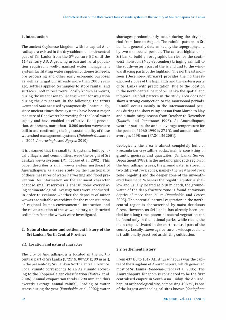
The ancient Ceylonese kingdom with its capital Anu-radhapura existed in the dry-subhumid north-central part of Sri Lanka from the 5th century BC until the 11th century AD. A growing urban and rural popula-tion required a well-organised water management system, facilitating water supplies for domestic needs, ore processing and other early economic purposes as well as irrigation. Already more than 2000 years ago, settlers applied techniques to store rainfall and surface runoff in reservoirs, locally known as wewas, during the wet season to use this water for irrigation during the dry season. In the following, the terms wewa and tank are used synonymously. Continuously, since ancient times these systems have been a major measure of floodwater harvesting for the local water supply and have enabled an effective flood preven-tion. At present, more than 10,000 ancient wewas are still in use, confirming the high sustainability of these watershed management systems (Dahdouh-Guebas et al. 2005, Amarasinghe and Nguyen 2010).
It is assumed that the small tank systems, built by lo-cal villagers and communities, were the origin of Sri Lanka’s wewa systems (Panabokke et al. 2002). This paper describes a small wewa system northeast of Anuradhapura as a case study on the functionality of these measures of water harvesting and flood pre-vention. As information on the sediment character of these small reservoirs is sparse, some overview-ing sedimentological investigations were conducted. In order to evaluate whether the deposits of minor wewas are suitable as archives for the reconstruction of regional human-environmental interaction and the reconstruction of the wewa history, undisturbed sedi ments from the wewas were investigated.
2. Natural character and settlement history of the Sri Lankan North Central Province
2.1 Location and natural character
The city of Anuradhapura is located in the north- central part of Sri Lanka (8°21’ N, 80°23’ E; 89 m asl), in the present-day Sri Lankan North Central Province. Local climate corresponds to an As climate accord-ing to the Köppen-Geiger classification (Kottek et al. 2006). Annual evaporation totals 1,290 mm and thus exceeds average annual rainfall, leading to water stress during the year (Panabokke et al. 2002); water
shortages predominantly occur during the dry pe-riod from June to August. The rainfall pattern in Sri Lanka is generally determined by the topography and by two monsoonal periods. The central highlands of Sri Lanka build an orographic barrier for the south-west monsoon (May-September) bringing rainfall to the southwestern part of the island and to the wind-wardfacing parts of the highland. The northeast mon-soon (December- February) provides the northeast- exposed slopes of the highlands and the eastern parts of Sri Lanka with precipitation. Due to the location in the north-central part of Sri Lanka the spatial and temporal rainfall pattern in the study area does not show a strong connection to the monsoonal periods. Rainfall occurs mainly in the intermonsoonal peri-ods during the short rainy season from March to May and a main rainy season from October to November (Domrös and Ranatunge 1993). At Anuradhapura weather station, the annual average temperature for the period of 1960-1990 is 27.1°C, and annual rainfall averages 1198 mm (FAOCLIM 2001).
Geologically the area is almost completely built of Precambrian crystalline rocks, mainly consisting of granitic gneisses and quartzites (Sri Lanka Survey Department 1988). In the metamorphic rock region of the Anuradhapura area, the groundwater is stored in two different rock zones, namely the weathered rock zone (regolith) and the deeper zone of the unweath-ered basement. Whereas the regolith aquifer is shal-low and usually located at 2-10 m depth, the ground-water of the deep fracture zone is found at various depths of more than 30 m (Panabokke and Perera 2005). The potential natural vegetation in the north-central region is characterised by moist deciduous forest. However, as Sri Lanka has already been set-tled for a long time, potential natural vegetation can be found only in the national parks, while rice is the main crop cultivated in the north-central part of the country. Locally, chena agriculture is widespread and is traditionally practised as shifting cultivation.
2.2 Settlement history
From 437 BC to 1017 AD, Anuradhapura was the capi-tal of the Kingdom of Anuradhapura, which governed most of Sri Lanka (Dahdouh-Guebas et al. 2005). The Anuradhapura Kingdom is considered to be the first centralised empire in South Asia. Today, the Anurad-hapura archaeological site, comprising 40 km2, is one of the largest archaeological sites known (Coningham
53DIE ERDE · Vol. 144 · 1/2013
Characterisation of the Rota Wewa tank cascade system in the vicinity of Anuradhapura, Sri Lanka
et al. 2007, Kohlmeyer 2010). Nowadays, Anuradhapura is listed as a UNESCO world heritage site and is cur-rently the capital of the North Central Province. The settlement history of Sri Lanka goes back to the Mesolithic, when the Balangoda Culture inhabited the island from 48 000 to 26 000 BC (Deraniyagala 1972). During the Early Iron Age (900 to 600 BC) a village-based agricultural and pastoral society developed, also involving household craft production, and the use of mineral resources became common. Findings from protohistoric sites indicate that animals had already been domesticated. In the hinterland of Anuradha-pura, the settlements of that time had a remarkable ribbon pattern spreading out alongside the river banks (Deraniyagala 1972).
Subsequent to the Iron Age, during the Early Histori-cal period, settlements in the Anuradhapura area not only lined the river banks but were also spread out in a cluster pattern which was linked to the location of artificial water reservoirs (wewas) as irrigation centres. The large-scale irrigation networks formed the economic basis for the closely related complex settlement patterns of the Early Historical period (Deraniyagala 1998). After the 4th century BC, the use of natural resources – for irrigation agriculture as well as for processing mineral resources – was in-tensified throughout the area of Anuradhapura. This coincides with a demographic expansion, the devel-opment of bigger chiefdoms and the establishment of a diverse social hierarchy. In the Early Historic era, state formation began and social stratification, the development of urban centres and long-distance trade emerged (Deraniyagala 1998).
3. The irrigation system of Sri Lanka
3.1 History of the wewa systems
The tank cascade systems of Sri Lanka date back to the ancient Anuradhapura period. They constitute a sophisticated watershed management structure enabling irrigation agriculture to be practised in the dry-subhumid regions of Sri Lanka (Mahatantila et al. 2008). The system is composed of thousands of hu-man-made reservoirs, locally known as wewas, their highest density can be found in the dry zone of Sri Lanka, where they facilitated agricultural production for more than 2000 years ( Jayatilaka et al. 2003). The wewas form a system of floodwater harvesting, water
storage and water distribution, mainly for the cultiva-tion of rice ( Jayatilaka et al. 2003).
According to the size of the reservoirs and their com-mand areas, they can be classified as major, medium, minor and micro irrigation works. Major wewas are defined as tanks with reservoir surface areas larger than 50 ha and command areas exceeding 80 ha. By contrast, the village tanks are much smaller, and their corresponding command areas are also significantly smaller; therefore they belong to the class of minor or micro irrigation works (Murray 2004). The wewas are located cascade-like along the valley courses and are connected by canals and spillways.
Written sources such as the Mahavasma, the chronicle of Sri Lanka, give evidence that the larger wewa sys-tems were constructed and directed by various kings from 300 BC onwards ( Jayasena and Selker 2004, Panabokke et al. 2002). The Bassawakkulama tank in Anuradhapura (107 ha reservoir surface) was built around 300 BC and is assumed to be the earliest large irrigation reservoir (Brohier 1934). All other ancient major irrigation works in Sri Lanka were most likely constructed later, namely in the period from 300 BC to 1200 AD (Chandrajith et al. 2008). During the historical period of Anuradhapura, the number of wewa systems steadily grew, reaching its peak in the period between the 8th and the 10th century AD in the hinterland of Anu-radhapura. In 993 AD Anuradhapura was destroyed by conquerors from South India (Domrös 1976) and the wewa cascade systems fell into disuse (Gilliland et al. 2013). These conquerors founded a new capitel 80 km southeast in Polonnaruwa. Here King Parakramabahu, who reigned in the 12th century AD, was famous for his tank-building activities. It is documented that he had built around 2500 major and minor tanks as well as more than 4000 canals (Kenyon et al. 2006). The con-struction and service of the large wewa systems was carried out by a small number of professional engi-neers and administrators (Kenyon et al. 2006).
By contrast, the thousands of small village tank sys-tems were designed and built by little village com-munities (Panabokke et al. 2002). Due to a lack of historical records it is still unclear when the con-struction of these small irrigation systems began. It is widely assumed that the construction of the vil-lage wewa systems developed out of the operation of rain-fed agriculture (Amarasinghe and Nguyen 2010, Panabokke 2010). Dahdouh-Guebas et al. (2005) es-timate that more than 30,000 human-made tanks
54 DIE ERDE · Vol. 144 · 1/2013
Characterisation of the Rota Wewa tank cascade system in the vicinity of Anuradhapura, Sri Lanka
were built all over Sri Lanka in historical times. Two thirds of these were village wewa systems (Zubair 2005). At present, more than 10,000 wewas are still in use (Dahdouh-Guebas et al. 2005, Amarasinghe and Nguyen 2010), belonging to approximately 3,500 tank cascade systems (Murray 2004). In the north-central region of Sri Lanka, especially after the 13th century AD, numerous major wewa systems fell into disrepair and were abandoned because of wars and epidemics (Zubair 2005). Under the British colonial administra-tion in the 19th century, several of the major ancient ir-rigation works were restored. After World War I, res-toration programmes also included numerous small village wewa systems, resulting in a “stabilisation of the small tank irrigated agriculture’’ within the dry zone of Sri Lanka (Panabokke et al. 2002).
3.2 Distribution of tanks and design of tank cascade systems
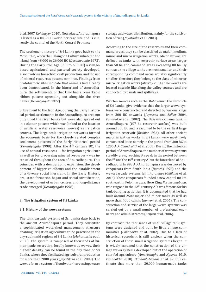
The spatial distribution of wewas is highly variable all over Sri Lanka and reaches the highest densities – with up to one tank per 1.2 km2 – in the North Western Province and the North Central Province (Panabokke et al. 2002). Ninety percent of these wewas are inte-gral parts of tank cascade systems (Fig. 1), where sur-face runoff is stored along a valley course. Each wewa cascade consists of up to 30 reservoirs of varying size; in general, reservoir size increases downstream ( Jay-atilaka et al. 2003). The village wewa systems are im-
pounded by earth dams that are constructed across the stream channels in order to collect runoff (Groenfeldt 2004). Wewa systems of neighbouring valleys can be linked by channels. The stored water is distributed to the downstream paddy fields via sluices (Mahatantila et al. 2008, Chandrajith et al. 2008), and overabundant wa-ter is conducted via spillways to the linked downstream wewa, preventing water loss (Itakura 1995).
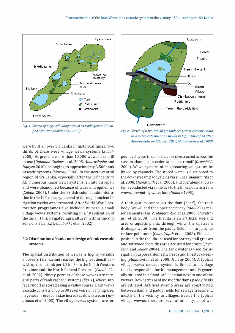
A tank system comprises the dam (bund), the tank body (wewa) and the upper periphery (thaulla) as ma-jor elements (Fig. 2; Mahatantila et al. 2008, Chandra-jith et al. 2008). The thaulla is an artificial wetland area of aquatic plants through which the upstream drainage water from the paddy fields has to pass to reduce pollutants (Chandrajith et al. 2008). Fines de-posited in the thaulla are used for pottery; tall grasses and softwood from this area are used for crafts ( Jaya-sena and Selker 2004). The tank water is used for ir-rigation purposes, domestic needs and livestock keep-ing (Mahatantila et al. 2008, Murray 2004). A typical village wewa cascade system is linked to a village that is responsible for its management and is gener-ally situated in a flood-safe location next to one of the wewas. Downstream of most of the dams paddy fields are situated. Artifical swamp areas are constructed between dam and paddy fields for sewage treatment, mostly in the vicinity to villages. Beside the typical village wewas, there are several other types of we-
Fig. 1 Sketch of a typical village wewa cascade system (modi-fied after Panabokke et al. 2002) Fig. 2 Sketch of a typical village tank ecosystem corresponding
to a micro-catchment as shown in Fig. 1 (modified after Amarasinghe and Nguyen 2010; Mahatantila et al. 2008)
55DIE ERDE · Vol. 144 · 1/2013
was: forest tanks, which are mainly built in the jungle and provide the wild animals with drinking water, or erosion control tanks functioning as siltation basins before runoff reaches the main tank (Goldsmith and Hildyard 1984, Zubair 2005).
3.3 Investigations on the wewas’ sedimentary environments
There are few studies available investigating the sedi-ments within the wewa cascade system. These studies were conducted to understand the ecosystem of a wewa cascade system and to develop pollution management plans, some investigations have explored the geo- and hydrochemistry of these systems, mainly to evaluate catchment weathering (Chandrajith et al. 2008), water quality (Mahatantila et al. 2008) and pollution due to the use of agrochemicals (Mahatantila et al. 2008, Chan-drajith et al. 2008). In general, the investigated tank sediments were proved to be unpolluted even though extensive rice cultivation was observed within the catchment (Chandrajith et al. 2008). The investigation of wewa sediments with the intention to reconstruct the palaeoenvironmental history is rare (Riether 1991).
4. Methods
4.1 Data processing and field work
Topographic maps at a scale of 1:50,000 (sheets: 25; 26; 30; 31) published by the Sri Lanka Survey Department (2003) were incorporated to support fieldwork and assist mapping in a GIS environment (Arc GIS 9.3 by ESRI). A digital elevation model (SRTM 3 90 m * 90 m pixel size) was used to delineate the catchment of the Aruvi Aru river and its sub-catchments.
The field campaign took place in March 2010. To ob-tain age models of the tank sediments and palaeoen-vironmental proxies, tubed sediments were extracted within the Rota Wewa tank cascade system using a percussion driller. Altogether, five sediment cores were extracted from four different tanks (Tab. 1, Fig. 4); results presented here refer to the sediment sequences RW01, RW03 and RW05. Hydrological and infrastructural features such as thaulla areas, spill-ways and sluices were systematically recorded by field mapping and GPS application (Garmin 60Cx). During the field campaign the wewas of the Rota Wewa cascade system were dry.
4.2 Sediment analysis
Sediment analysis was performed at the Physical Geo-graphy laboratory, Department of Earth Sciences, FU Berlin. The lithostratigraphy of all sediment sequences was described. Magnetic susceptibility measurements were performed before sampling by using the core scanning sensor type MS2C of a Bartington System with horizontal logging. The cores were passed through the sensor in half-sections, and measurements were taken at 4 cm intervals. The calculated ratio of volume sus-ceptibility (κ) is dimensionless and was measured in SI units. A calibration check was provided by using a cali-bration sample. The drift of the sensor was evaluated by measurements of air before and after each core.
Due to the homogeneous nature of the sediments, caused by wave motions in the shallow water of the tanks and disturb laminations and event layers, sam-pling was done at 10-20 cm intervals, extracting 2 cm thick bulk samples. Sediment samples were reduced to fines < 2 mm Ø. After air drying, half of each sam-ple was homogenised with an agate disc swing mill for further mineralogical and chemical analysis.
4.3 Texture
A Beckman-Coulter LS 13320 PIDS laser diffraction par-ticle size analyser was used for determining the grain-size distributions of selected samples. The ana lysis was carried out at the laboratories of the Leibniz Institute for Applied Geophysics (LIAG) in Hanover. Grain-size distri-butions are shown in vol.-%. Due to the small contents of organic matter in the sediments (mean = 0.27 mass-%) organic material was not removed from samples prior to the measurements (cf. Beuselinck et al. 1998, Machalett et al. 2008). Carbonate contents were also negligible and were therefore not removed before analysis. The grain-size distribution displayed shows the clay, silt and sand distribution with the clay fraction comprising grain sizes < 5.5 µm. As lamination and event layers do not occur in the wewa sediments analysed, this procedure proves to be sufficient to identify the boundary between the in-situ weathered bedrock and the overlying alloch-thonous river and reservoir deposits.
4.4 Bulk parameters
The electrical conductivity of the water-saturated sedi ments was measured with the DIST 3 (HANNA)
Characterisation of the Rota Wewa tank cascade system in the vicinity of Anuradhapura, Sri Lanka
56 DIE ERDE · Vol. 144 · 1/2013
conductometer in a suspension of 5 g of dried sedi-ments and 12.5 ml of distilled water after a 30 min re-action time. The total and inorganic carbon contents were determined using a carbon analyser (Woesthoff Carmho graph). The total carbon contents (TC mass-%) were determined by dry combustion of 0.1 g of the ho-mogenised sample at 1000°C in an oxygen atmosphere and subsequent quantification of the evolved CO2 in 20 ml 0.05 N NaOH solution by conductivity (Woesthoff Carmhograph 16). For the analysis of the total inor-ganic carbon content (TIC mass-%), CO2 was evolved during acid (H3PO4) treatment of 0.1 g of homogenised sediment and quantified by a similar conductometric method to that used for the TC content. The total or-ganic carbon content (TOC mass-%) was calculated by subtraction of TIC from TC. Calcite (CaCO3) was used as the calibration standard for TC (12.01 ± 0.15 %; RSD < 2 %) and TIC (12.01 ± 0.38 %; RSD < 4 %) analyses.
4.5 Chemical analysis
Samples were analysed for the major element concen-trations of S, Mn and Fe using an inductively coupled
plasma optical emission spectrometer (ICP-OES Per-kin Elmer Optima 2100DV). Dilutions of 1.0 g of dry homogenised sediment were produced with a nitro-hydrochloric acid (aqua regia) dilution according to DIN EN 13346 (2001) and with hydrochloric acid (25 ml of 3 % HCl). For data quality control a certified reference material (LGC6156; Portsmouth harbour sediment < 200 μm), duplicate dilutions, and blank reagents were used (Schütt et al. 2010).
4.6 Mineralogical analysis
Mineralogical analysis was exemplarily applied to the sediments of core RW03 to gain information on the mineralogical composition of the sediments. Powder samples were analysed by X-ray diffraction (PW 1710, Philips) using a copper kα-tube from 3-70°2θ with steps of 0.02°2θ, each step being measured for two seconds. Contents of mineral components were quantitatively derived from diffraction intensity and the area framed by the peak using Philips X’Pert HighScore software. Accuracies of measurement and detection limits are specific to minerals. Accuracy of measurement aver-
Characterisation of the Rota Wewa tank cascade system in the vicinity of Anuradhapura, Sri Lanka
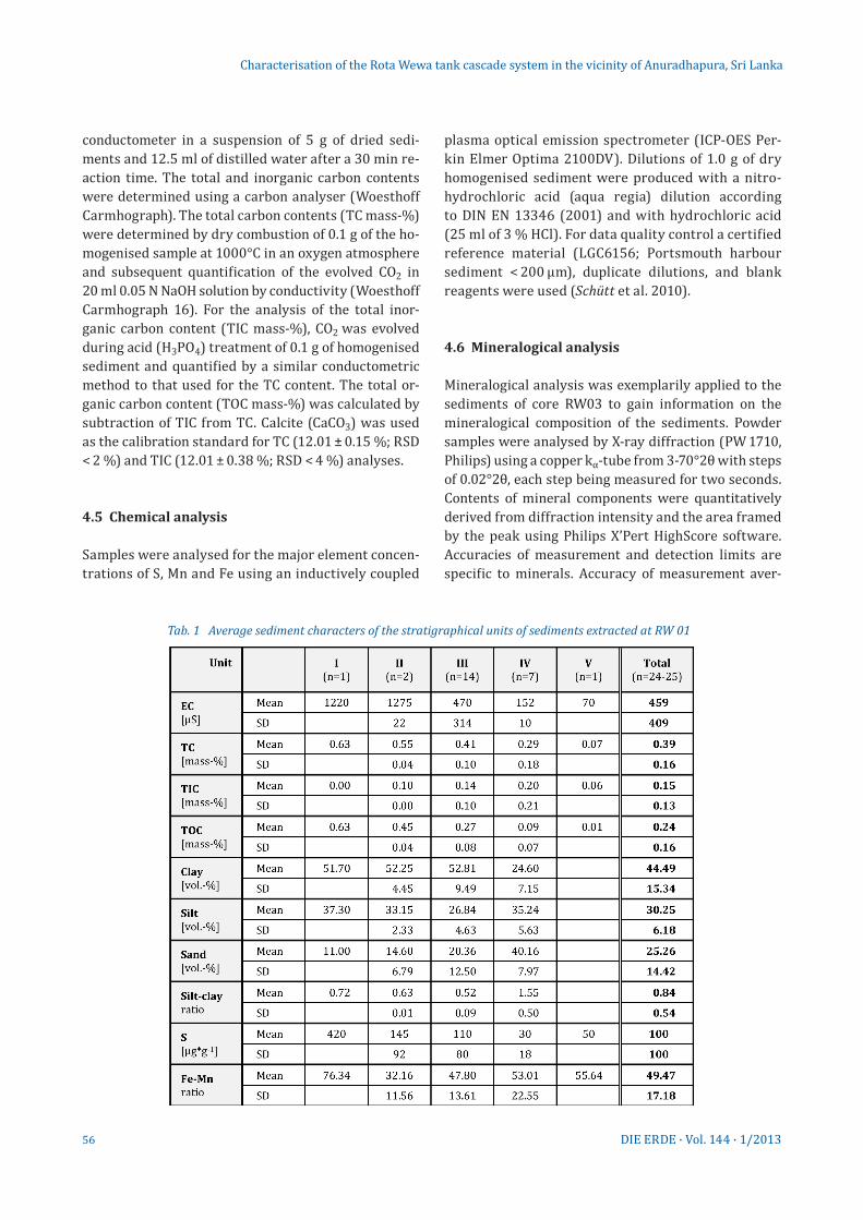
Tab. 1 Average sediment characters of the stratigraphical units of sediments extracted at RW 01
57DIE ERDE · Vol. 144 · 1/2013
ages 0.05°2θ for quartz. The detection limit depends on the location of the major diffraction peak d100, sample preparation and quality of grinding stock (particle size) as well as on instrument settings (Schütt et al. 2010).
4.7 Dating
The chronological frame of the tank sediments was set up by AMS radiocarbon dating of six samples. Analyses were carried out at the Radiocarbon Laboratory in Poznan, Poland. Sample preparation included manual removing of recent rootlets. The radiocarbon ages were calibrated
using the software OxCal (v. 4.1) and the IntCal09 calibra-tion curve by Reimer et al. (2009). The radiocarbon ages were calibrated to weighted calendar years and their range, and are reported as calibrated years BC (Tab. 1).
4.8 Data Analysis
Referring to Schütt (e.g., Schütt 1998a, 1998b, 2004a, 2004b; Schütt et al. 2010; Schwanghart et al. 2008; Schwanghart et al. 2009) data analysis was conducted for homogeneous sediment units, set on the basis of the lithostratigraphical description and the run of the
Characterisation of the Rota Wewa tank cascade system in the vicinity of Anuradhapura, Sri Lanka
Tab. 2 Samples and core data for 14C chronology of the Rota Wewa system (P.-o.m.-b.s. = Plants – organic material – bulk sediment)
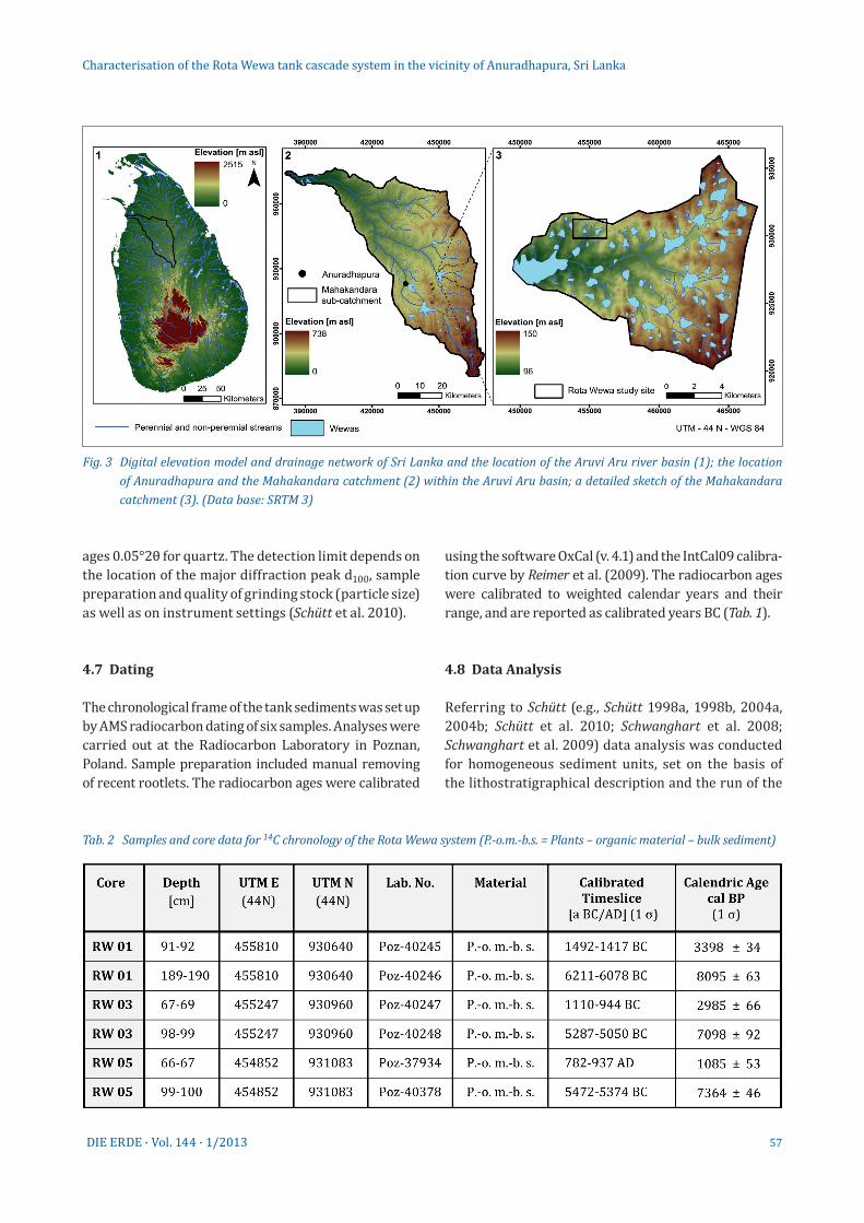
Fig. 3 Digital elevation model and drainage network of Sri Lanka and the location of the Aruvi Aru river basin (1); the location of Anuradhapura and the Mahakandara catchment (2) within the Aruvi Aru basin; a detailed sketch of the Mahakandara catchment (3). (Data base: SRTM 3)
58 DIE ERDE · Vol. 144 · 1/2013
respective sediment parameters (bulk parameters, chemical parameters, mineralogical parameters, tex-ture). Each unit is characterised by mean and standard deviation (SD), single values were only regarded where minimum or maximum outliers occurred. This method has proven to be suitable for non-laminated sediments where event layers are also missing, as it is typical for shallow lake systems to which the wewas also belong (see comprehensive description in Schütt 2004b).
5. The Rota Wewa tank system
The Rota Wewa is a village tank system about 30 km east of Anuradhapura; it is part of a sub-catchment of the Mahakandara reservoir, located in the catchment of the river Aruvi Aru (Fig. 3). This major-scale tank is supplied by several wewa cascade systems, altogether consisting of around 100 small tanks. The Rota Wewa cascade system is located in the upper reaches of a small cascade in the northwest of the Mahakandara reservoir, composed of four tanks with a total drain-age basin area of 2.9 km2, approximately 12 % of which is covered by the reservoirs themselves (tank surface area). All the investigated tanks are shallow with maxi-mum water levels of c. 2 m and thus dry up periodically.
With an average slope of about 0.9°, the relief of the Rota Wewa cascade drainage basin is plane, with very flat valleys and shallow divides. The four tanks of the Rota
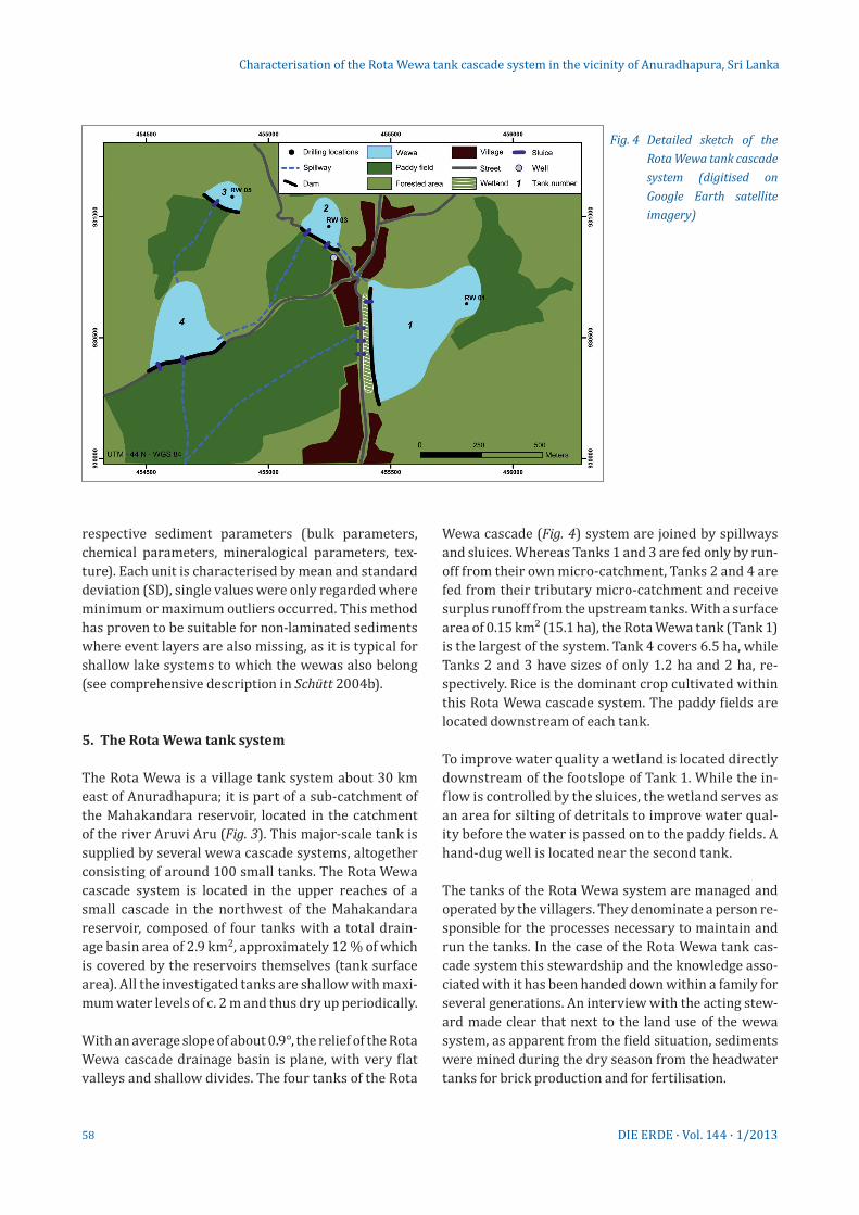
Wewa cascade (Fig. 4) system are joined by spillways and sluices. Whereas Tanks 1 and 3 are fed only by run-off from their own micro-catchment, Tanks 2 and 4 are fed from their tributary micro-catchment and receive surplus runoff from the upstream tanks. With a surface area of 0.15 km² (15.1 ha), the Rota Wewa tank (Tank 1) is the largest of the system. Tank 4 covers 6.5 ha, while Tanks 2 and 3 have sizes of only 1.2 ha and 2 ha, re-spectively. Rice is the dominant crop cultivated within this Rota Wewa cascade system. The paddy fields are located downstream of each tank.
To improve water quality a wetland is located directly downstream of the footslope of Tank 1. While the in-flow is controlled by the sluices, the wetland serves as an area for silting of detritals to improve water qual-ity before the water is passed on to the paddy fields. A hand-dug well is located near the second tank.
The tanks of the Rota Wewa system are managed and operated by the villagers. They denominate a person re-sponsible for the processes necessary to maintain and run the tanks. In the case of the Rota Wewa tank cas-cade system this stewardship and the knowledge asso-ciated with it has been handed down within a family for several generations. An interview with the acting stew-ard made clear that next to the land use of the wewa system, as apparent from the field situation, sediments were mined during the dry season from the head water tanks for brick production and for fertilisation.
Characterisation of the Rota Wewa tank cascade system in the vicinity of Anuradhapura, Sri Lanka
Fig. 4 Detailed sketch of the Rota Wewa tank cascade system (digitised on Google Earth satellite imagery)
59DIE ERDE · Vol. 144 · 1/2013
6. Sediments extracted from the Rota Wewa tank system
6.1 RW 01
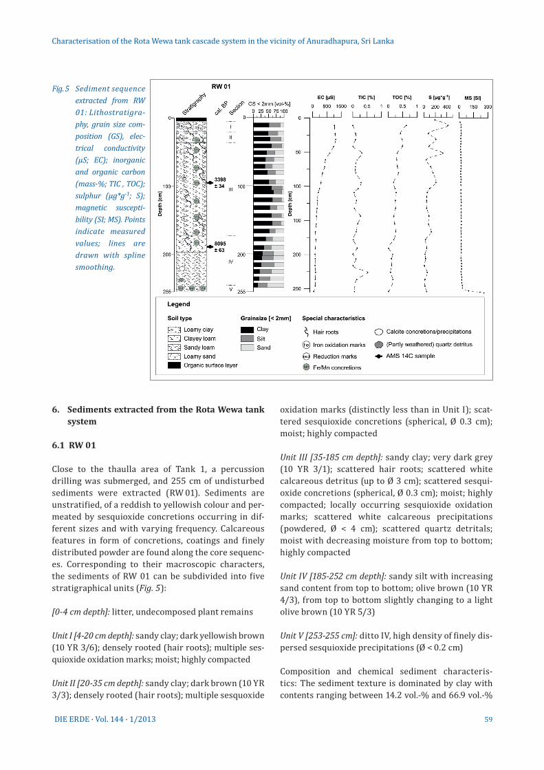
Close to the thaulla area of Tank 1, a percussion drilling was submerged, and 255 cm of undisturbed sediments were extracted (RW 01). Sediments are unstratified, of a reddish to yellowish colour and per-meated by sesquioxide concretions occurring in dif-ferent sizes and with varying frequency. Calcareous features in form of concretions, coatings and finely distributed powder are found along the core sequenc-es. Corresponding to their macroscopic characters, the sediments of RW 01 can be subdivided into five stratigraphical units (Fig. 5):
[0-4 cm depth]: litter, undecomposed plant remains
Unit I [4-20 cm depth]: sandy clay; dark yellowish brown (10 YR 3/6); densely rooted (hair roots); multiple ses-quioxide oxidation marks; moist; highly compacted
Unit II [20-35 cm depth]: sandy clay; dark brown (10 YR 3/3); densely rooted (hair roots); multiple sesquoxide
oxidation marks (distinctly less than in Unit I); scat-tered sesquioxide concretions (spherical, Ø 0.3 cm); moist; highly compacted
Unit III [35-185 cm depth]: sandy clay; very dark grey (10 YR 3/1); scattered hair roots; scattered white calcareous detritus (up to Ø 3 cm); scattered sesqui-oxide concretions (spherical, Ø 0.3 cm); moist; highly compacted; locally occurring sesquioxide oxidation marks; scattered white calcareous precipitations (powdered, Ø < 4 cm); scattered quartz detritals; moist with decreasing moisture from top to bottom; highly compacted
Unit IV [185-252 cm depth]: sandy silt with increasing sand content from top to bottom; olive brown (10 YR 4/3), from top to bottom slightly changing to a light olive brown (10 YR 5/3)
Unit V [253-255 cm]: ditto IV, high density of finely dis-persed sesquioxide precipitations (Ø < 0.2 cm)
Composition and chemical sediment characteris-tics: The sediment texture is dominated by clay with contents ranging between 14.2 vol.-% and 66.9 vol.-%
Characterisation of the Rota Wewa tank cascade system in the vicinity of Anuradhapura, Sri Lanka
Fig. 5 Sediment sequence ex tracted from RW 01: Lithostratigra-phy, grain size com-position (GS), elec-trical conductivity (µS; EC); inorganic and organic carbon (mass-%; TIC , TOC); sulphur (µg*g-1; S); magnetic suscepti-bility (SI; MS). Points indicate measured values; lines are drawn with spline smoothing.
60 DIE ERDE · Vol. 144 · 1/2013
(mean: 44.5 vol.-%, std. = 15.34, n=24). While clay dom-inates from Unit III down to 150 cm depth, it continu-ously decreases from 150 cm depth down to the base (Fig. 5, Tab. 1). With decreasing clay contents, silt and sand contents increase. The silt-clay ratio averages 0.84 (std. = 0.54, n = 24), showing significantly lower values in Units I-III (mean = 0.52-0.72 vol.-%, n = 1-14) than in Unit IV (mean = 1.55 vol.-%, std. 0.50, n = 7) (α < 0.01). Sand contents are of high variability ranging between 5.5 vol.-% at the top and 55.0 vol.-% at the base and in-creasing continuously from top to bottom (Tab. 1).
The electrical conductivity values of the sediment saturation extract decreases constantly from top to bottom, reaching values of 1290 µS close to the surface and dropping to 70 µS at the base. The total carbon con-tents of the sediment sequence are generally low, rang-ing between 0.07 % and 0.63 % (mean = 0.39 mass-%, std. = 0.16, n = 25; Tab. 1). Also the organic carbon con-tents of the sediments contin uously decrease from top to bottom, totalling 0.63 mass-% close to the surface (Unit I) and dropping to 0.01 mass-% in Unit V. Inor-ganic carbon contents average 0.15 mass-% (std. = 0.13,
n = 25) throughout the sequence, undergoing strong oscillations; the total inorganic carbon contents peak at 50 cm depth, 80 cm depth and 225 cm depth, reach-ing maximum values of 0.59 mass-% in core section IV. Also the sediment’s sulphur contents are highly varia-ble, ranging from 10 to 420 µg*g-1 (mean = 100 µg*g-1, std. = 100, n = 25) showing local peaks parallel to the peaks of the inorganic carbon content and reach-ing maximum values in the uppermost core sections (Units I–III). The Fe-Mn ratios reach their highest val-ues in Unit I, being considerably lower in section II and increasing gradually from Units III to V (mean = 49.47, std. = 17.18, n = 25; cf. Tab. 2). Magnetic susceptibility values are generally very low (< 25 SI) but suddenly in-crease in Unit V, reaching values of up to 300 SI.
To set up a chronological frame of the sediments ex-tracted in RW 01, two samples of bulk organic material were analysed to determine their radiocarbon ages (Tab. 2). The radiocarbon dates (AMS) show ages of 8095 ± 63 cal yr BP at 199 cm depth and 3398 ± 34 cal yr BC at 91 cm depth, indicating a Holocene chronol-ogy of the sediment sequence.
Characterisation of the Rota Wewa tank cascade system in the vicinity of Anuradhapura, Sri Lanka
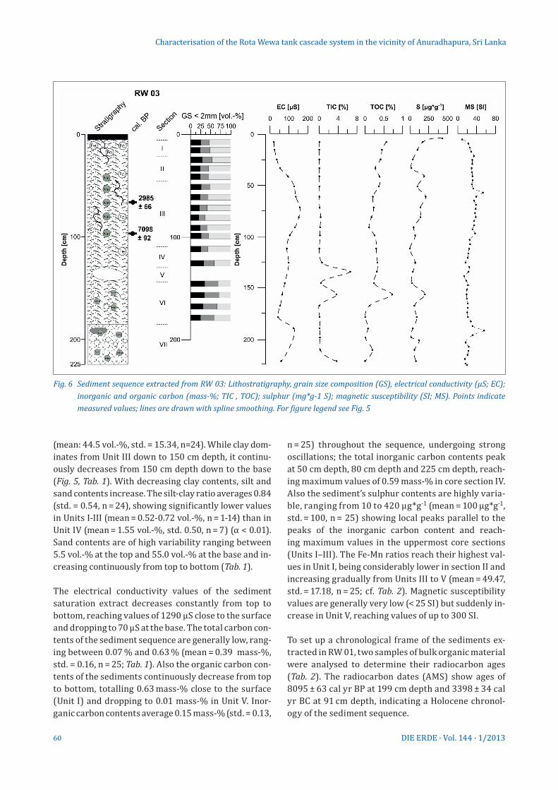
Fig. 6 Sediment sequence extracted from RW 03: Lithostratigraphy, grain size composition (GS), electrical conductivity (µS; EC); inorganic and organic carbon (mass-%; TIC , TOC); sulphur (mg*g-1 S); magnetic susceptibility (SI; MS). Points indicate measured values; lines are drawn with spline smoothing. For figure legend see Fig. 5
61DIE ERDE · Vol. 144 · 1/2013
6.2 RW 03
In the central part of Tank 2, approximately 80 m be-hind the dam, a percussion drilling extracted 225 cm of undisturbed sediments. These sediments are non-stratified, of a brownish colour, and permeated by sesquioxide concretions varying in size and concen-tration. Calcareous features in form of concretions, coatings and finely distributed powder are found along the core sequences.
Corresponding to their macroscopic characters, the sediments are subdivided into seven stratigraphical units (Fig. 6):
[0-4 cm]: litter, undecomposed plant remains
Unit I [4-21 cm]: sandy loam; dark brown (7.5 YR 4/6); weakly rooted (hair roots), strong sesquioxide oxida-tion marks; dry; highly compacted
Unit II [21-45 cm]: sandy-clayey loam; dark brown (10 YR 3/3); moderately rooted (hair roots); moist;
highly compacted; mottled sesquioxide oxidation marks; scattered sesquioxide concretions Ø < 2 mm
Unit III [45-110 cm]: sandy-clayey loam; very dark greyish brown (10 YR 3/2) to dark yellowish brown (10 YR 4/4); moderately to weakly rooted (hair roots); moist; highly compacted; scattered sesquioxide con-cretions (up to 3-4 mm Ø); isolated calcareous concre-tions (powdered, up to 1 cm Ø)
Unit IV [110-128 cm]: sandy clayey loam; dark grey-ish brown (10 YR 4/2); not rooted, moist, moderately compacted, sesquioxide oxidation marks
Unit V [128-146 cm]: decomposed calcareous detrital (brownish grey; 10 YR 6/2) appearing in its original struc-ture and embedded in a matrix of sandy loam (dark greyish brown; 10 YR 4/2); not rooted; moist; highly compacted
Unit VI [146-185 cm]: sandy to clayey loam; dark grey-ish brown (10 YR 4/2); not rooted; moist; moderately compacted; scattered sesquioxide concretions (Ø < 1 cm), scattered calcareous concretions (Ø < 0.5 cm)
Characterisation of the Rota Wewa tank cascade system in the vicinity of Anuradhapura, Sri Lanka
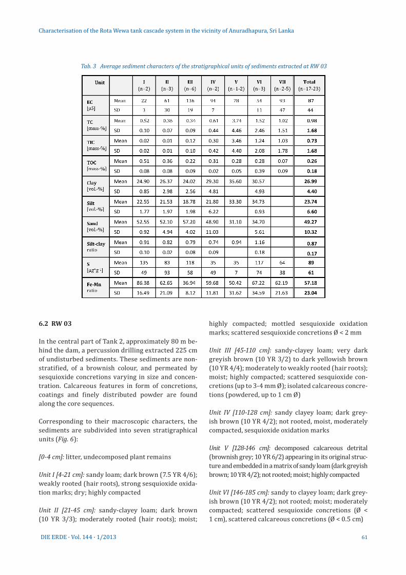
Tab. 3 Average sediment characters of the stratigraphical units of sediments extracted at RW 03
62 DIE ERDE · Vol. 144 · 1/2013
Unit VII [185-225 cm]: sandy; crumbly; yellowish brown (10 YR 5/8); not rooted; scattered sesquioxide concretions; moist; highly compacted
Composition and chemical sediment characteris-tics: Sand dominates the extracted sediments with contents of 29.30-63.90 vol.-% (mean = 49.27 vol.-%, std. = 10.32, n = 17); sand contents decrease from top to bottom (Tab. 3). The silt contents vary between 15.50 vol.-% and 35.80 vol.-%, averaging 23.74 vol.-% (std. = 6.60, n = 17). The contents of the clay remain below 20.60 vol.-% (mean = 16.99, std. = 4.40, n = 17). The silt-clay ratio averages 0.88 (std. = 0.17, n = 17), lacking statistically significant differences between the different units (α > 0.05).
The mineral composition of the sediments from RW 03 is dominated by quartz and feldspars with an average of 37 vol.-% quartz (std. = 15.7, n = 23) and 57 vol.-% feldspar (std. = 14.4, n = 23). Quartz contents are nega-tively correlated to feldspar contents (r = -0.7, n = 23; α < 0.05). Amphiboles occur at 180-225 cm depth with
contents of up to 15 vol.-%. Calcite frequently occurs in Units V and VI, corresponding to the macroscopically described calcareous features. The variability of calcite contents is high, ranging between 2 and 50 vol.-%. Clay minerals were detected with only very low concentra-tions along the whole sediment sequence.
The electrical conductivity values of the water-saturated samples range between 20 µS and 158 µS (mean = 87 µS, std. = 44, n = 19), being particularly low in the uppermost Units I and II. The total carbon contents show a high variability with values ranging between 0.0 and 6.89 mass-% (std. = 1.68, n = 23). The total organic carbon contents are highest in the sedi-ments close to the surface (Unit I and Unit II), reaching values of 0.6 mass-% TOC; they also peak at 155 cm depth, reaching similar concentrations to those in the uppermost layers. Total inorganic carbon contents av-erage 0.73 mass-% (std. = 1.68, n = 22) and reach maxima of 6.57 mass-% in Unit V and 3.69 mass-% in Unit VII, corresponding to the occurrence of calcite. The sul-phur contents are generally lower than in core RW 01,
Characterisation of the Rota Wewa tank cascade system in the vicinity of Anuradhapura, Sri Lanka
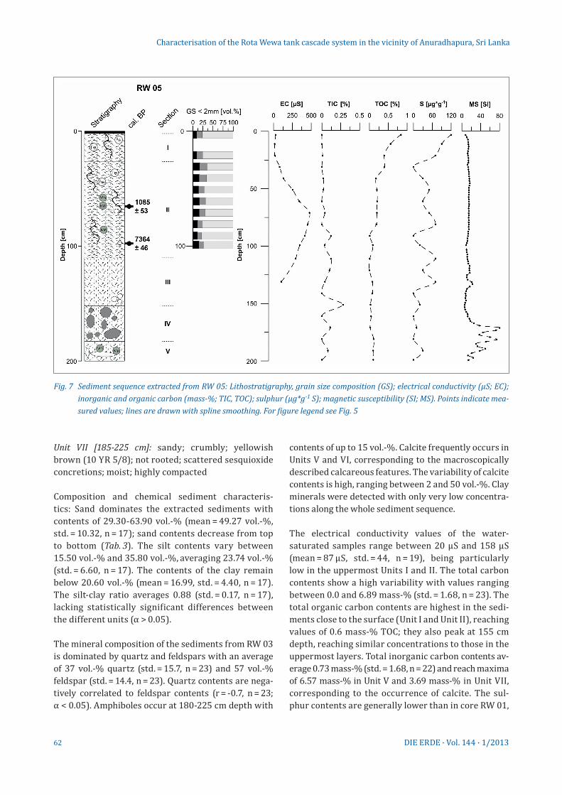
Fig. 7 Sediment sequence extracted from RW 05: Lithostratigraphy, grain size composition (GS); electrical conductivity (µS; EC); inorganic and organic carbon (mass-%; TIC, TOC); sulphur (µg*g-1 S); magnetic susceptibility (SI; MS). Points indicate mea-sured values; lines are drawn with spline smoothing. For figure legend see Fig. 5
63DIE ERDE · Vol. 144 · 1/2013
reaching a maximum value of 210 µg*g-1 parallel to the total organic carbon peak in Unit VI and showing the highest contents in Units I to III (mean = 89 µg*g-1, std. = 61, n = 23). The Fe-Mn ratios are highly variable, ranging between 28.06 and 103.05 (mean = 57.18, std = 23.04, n = 23) reaching their highest values in Unit I and lowest values in Unit III. Magnetic suscep-tibility values are generally low, reaching scattered maxima of up to 70 SI in Units III and VII.
The radiocarbon dates (AMS) from two samples of organic bulk sediments yield ages of 2985 ± 66 cal a BP at a depth of 68 cm and 7098 ± 92 cal a BP at a depth of 98 cm, providing a Holocene chronology of the sediment sequence.
6.3 RW 05
The sediments extracted in the percussion drilling RW 05 originate from the central part of Tank 3, lo-cated 50 metres upstream of the dam. The profile to-tals about 200 cm. The extracted sediments are not
stratified. The basal part shows the highly weathered saprolite, superimposed by the wewa’s stillwater sediments. The colour is brownish throughout. Cor-responding to their macroscopic characters, the sedi-ments are subdivided into five stratigraphical units:
[0-2 cm]: litter, undecomposed plant remains
Unit I [2-26 cm]: sandy; yellowish brown (10YR 5/3); weakly rooted (hair roots); dry; highly compacted
Unit II [26-110 cm]: sandy loam; dark greyish brown (10 YR 4/2); weakly rooted (hair roots); moist; high-ly compacted; scattered sesquioxide concretions (Ø 2-3 mm); scattered calcareous nodules (up to Ø 1 cm; very pale brown, 10 YR 8/2); increasing mois-ture in the middle of the unit; mottled sesquioxide oxi-dation marks between 33 and 41 cm depth
Unit III [110-155 cm]: mixed layer of sandy (brown-ish yellow, 10 YR 6/6) and loamy sediments (greyish brown, 10 YR 5/2); crumbly; not rooted; moist; highly compacted; scattered carbonate precipitations
Characterisation of the Rota Wewa tank cascade system in the vicinity of Anuradhapura, Sri Lanka
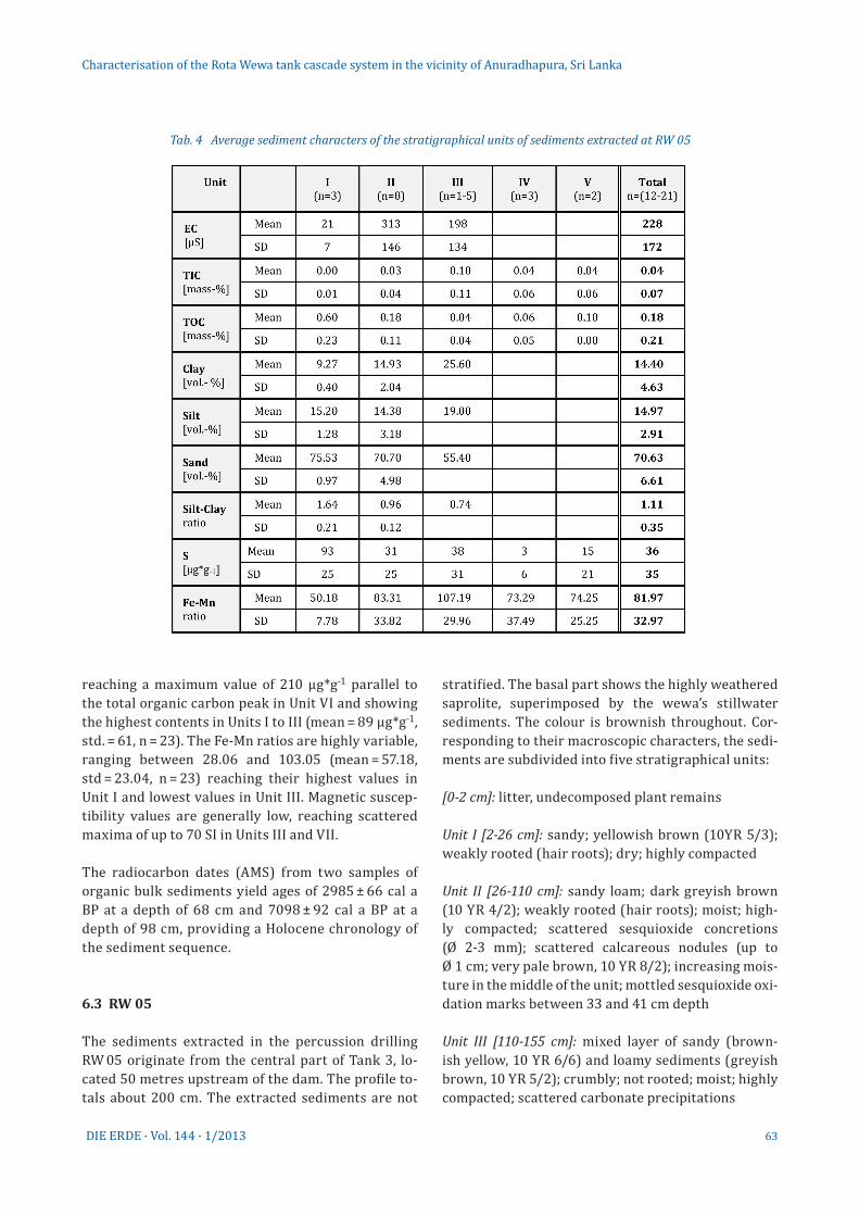
Tab. 4 Average sediment characters of the stratigraphical units of sediments extracted at RW 05
64 DIE ERDE · Vol. 144 · 1/2013
Unit IV [155-181 cm]: ditto Unit III; but increased inci-dence of partly weathered quartzite detritals
Unit V [181-200 cm]: ditto Unit III; but scattered sesqui-oxide concretions (very small)
Grain-size distributions of Units I and II (Fig. 7) do not show significant differences. Sediments exposed in Units III–V were presumably formed by weathering of the parent rock material, corresponding to saprolite.
Composition and chemical sediment characteris-tics: Analysis of sediment texture focuses on Units I and II. In these sediment sequences the sand frac-tion dominates, reaching contents up to 78.70 vol.-% (mean = 70.63 vol.-%, std = 6.61, n = 12), while the sand contents in Units I and II increase from top to bottom (Tab. 4). The sand contents of Unit III are considerably lower than in Units I and II. The silt fraction contents average 14.97 vol.-% (std. = 2.91, n = 12). The contents of the clay fraction range from 8.81 vol.-% to 25.60 vol.-% (mean = 14.40 vol.-%, std. = 4.63, n = 12), being particularly low in Unit I and increasing from top to bottom. The silt-clay ratios average 1.11 (std. = 0.35, n = 12) and are significantly higher in Unit I (mean = 1.64, n = 3) than in Units II and III (n = 1) (α < 0.05).
The electrical conductivity values of the moist sedi ment samples are low, ranging from 16 µS to 478 µS (mean = 228 µS, std. = 172, n = 13), being particularly low in Unit I, while the highest values are recorded in Unit II (Tab. 4). The total carbon contents average 0.23 mass-% (std. = 0.19, n = 21). Accordingly, the TOC contents are low, reflected by an average of 0.18 mass-% (std. = 0.21, n = 21) with decreasing concentrations from top to bottom (Tab. 4). Total inorganic carbon contents (TIC) av-erage 0.04 mass-% (std. = 1.68, n = 22) and reach a maximum of 0.28 mass-% in Unit III at a depth of 151 cm, corresponding to the occurrence of calcite. The sulphur contents in the sediments of RW 05 are significantly lower than those of the sediments from RW 01 and RW 03, reaching a maximum value of 120 µg*g-1 in Unit I (mean = 36 µg*g-1, std. = 35, n = 21). The Fe-Mn ratios show a high variability, with values ranging from 37.92 to 138.19 (mean = 81.97, std. = 32.97, n = 21). The highest Fe-Mn ratios are reached in Units II and III. Magnetic susceptibil-ity values are very low in Units I to III, increasing to the base of the extracted sediments and reaching a maximum value of 78 SI in Unit IV.
7. Discussion of the sediment records
7.1 Reliability of the chronology
Radiocarbon dating of lake sediments based on bulk samples is associated with several problems. Major sources for errors are related to the fact that carbon from uncertain origins is used for dating (Grimm et al. 2009), for instance the “hardwater effect”, describing the occurrence of old-carbon reservoirs (e. g. bedrock, lignite, coal, carbonaceous shales) (Nambudiri et al. 1980, Lowe et al. 1988 and Grimm and Jacobson 2004). This effect leads to an overestimation of ages.
The carbonates detected in the sediments from the Rota Wewa system correspond to calcites. The con-cretion-like appearance of the carbonates points to their post-sedimentary precipitation along desicca-tion cracks or roots during the desiccation and simul-taneous concentration of solutions (Sonnenfeld 1984). In Sri Lanka, the occurrence of calcite precipitations in the form of concretions is a common morphologi-cal feature in the soils of the dry zone, as described by Panabokke (1959) and Moorman and Panabokke (1961). Panabokke (1959) assumes that the soluble calcium derives from the soils in the upper regions of the valleys and is due to the downward movement of water. Once in dissolution, the calcium is transported in the lateral subsoil flow and precipitates as calcare-ous concretions in the poorly drained soils of the less elevated areas. As carbonates do not occur in the bed-rock of the drainage basin, it has to be concluded that the calcites found are authigenic or originate from or-ganisms (shells, bones) (Schütt et al. 2005).
Other sources for errors, which are related to the wewa sediment, might lead to an underestimation of ages: (1) vertical dislocation of humic acids, (2) fluctu-ations of the ground water and water table of the we-was, (3) incomplete removal of recent rootlets/roots (4) bioturbation (Premathilake 2009, Possnert 1990). Even taking these sources for errors into account the absolute age data provide a rough chronology. How-ever, the six radiocarbon ages analysed for three sedi-ment sequences relate plausibly.
7.2 Sediment characters The grain-size compositions of all three sediment sequences document the allochthonous origin of the
Characterisation of the Rota Wewa tank cascade system in the vicinity of Anuradhapura, Sri Lanka
65DIE ERDE · Vol. 144 · 1/2013
sediments (Dunne et al. 1991, Folk 1966) and foster to point out the transition between autochthonous weath-ered bedrock and allochthonous tank sediments. In the sediment sequences of RW 01 and RW 05, the Sl values of magnetic susceptibility document the transition from the highly weathered bedrock – sapro lite devel-oped in the parent granitic gneisses and quartzites – to the overlying sediment units. In RW 03 this transition is detectable only macroscopically and is represented by loamy sand in which partly weathered quartz detritus is embedded, but SI values do not give a clear indication.
To distinguish between the wewa sediments and the fluvial deposits of the valleys in which the wewas were built, the radiocarbon ages give valuable information. Ages of the sediments from RW 01 and RW 03 clearly indicate that large parts of both sequences were al-ready deposited before the ancient Anuradhapura pe-riod. Also, the basal sediments exposed in RW 05 were deposited before the ancient Anuradhapura period, whereas overlying sediments only 30 cm above origi-nate from the 9th century AD. This indicates that the tank system was constructed in a fluvial accumula-tion zone (Patt et al. 2011), corresponding to the over-all slightly rolling relief whose small gradients retard turbulent runoff and erosion processes (Ahnert 2009).However, for all three sediment sequences, only one radiocarbon age matches the ancient Anuradhapura period, at least documenting that historical wewa sediments do exist, an observation that is contrary to the assumption by Riether (1991). The hiatus of younger sediments can most likely be explained by the removal of sediments by the local villagers. As in-terviews with the local population showed, particu-larly sediments from wewas in the headwater areas are removed when the reservoirs have fallen dry and are used for construction purposes, either for brick production, as packed earth or as a fertiliser alterna-tive. The removed sediments are predominantly the uncompacted, most recent deposits.
In all three sediment sequences extracted, local in-creases in the electrical conductivity values of the water-saturated samples along the profile trace the dry front of the desiccating reservoir (Sonnenfeld 1984). The high fraction of quartz and silicates in the mineralogical composition of the reservoir sediments affirms their detrital origin (Schütt 2004b).
In perennial lakes, the decomposition of suspended organic matter is predominantly controlled by oxida-tion, whereas after deposition the decay of organic
matter is continued by anaerobic bacteria (Meyers and Ishiwatari 1993) and can result in the total decompo-sition of organic matter (Livingstone 1984). Conse-quently, high decomposition rates can be expected in ephemeral or periodical lakes during desiccation. Organic carbon contents in the sediments from tanks of the Rota Wewa system are very low, and decreasing contents of organic carbon from top to bottom sug-gest a progressively early diagenetic decomposition of organic matter (Rheinheimer 1974), which is forced by light, high temperatures and oxygen (Vallentyne 1962). Locally increased organic carbon contents might cor-respond to the deposition of larger plant remains and soil organic matter as a consequence of flood events and concurrent erosion processes in the drainage ba-sin (Dunne et al. 1991). In general, increased organic carbon contents of lacustrine sediments indicate dep-osition rates higher than decomposition rates such as those caused by soil erosion processes (Lerman 1979).
Sesquioxide precipitation in all three sediment se-quences document oxidising processes during desic-cation of the wewa systems presented here (Schütt 2004a). In the three sediment profiles, Fe-Mn ratios increase from top to bottom. As Mn in lacustrine sediments indicates drainage basin conditions, it is often standardised to Fe by means of the Fe-Mn ratio (Mackereth 1966, Boyle 2001, Schütt 2004a). While Fe contents are highly correlated to the lithogenous Fe contents, Mn contents are related to soil-forming processes during which it can be mobilised more easi-ly than iron under reducing conditions (Schlichting and Schweikle 1980). In consequence it is assumed that in-creased Fe-Mn ratios document increased input of de-tritals, whereas decreased Fe-Mn ratios are evidence of phases with extended wetland areas in the wewa margin. Hence, the inflowing groundwater is enriched by dissolved Mn, which is subsequently incorporated in the lake sediments (Schwanghart et al. 2008).
Sulphur contents in the analysed sediments are mostly close to the detection limit and repeatedly show local increases. As the parent bedrock in the Rota Wewa drainage basin is granite and gneiss, a geogenic origin of the sulphur contents in the res-ervoir sediments is excluded. Since peaks in sulphur contents repeatedly coincide with peaks in organic carbon content, it is concluded that sulphur in the reservoir sediments originates from the decay of or-ganic deposits. Sulphur is concentrated as enzyme or amino acid in organic material and is reduced and removed during microbial decay (Swain 1970).
Characterisation of the Rota Wewa tank cascade system in the vicinity of Anuradhapura, Sri Lanka
66 DIE ERDE · Vol. 144 · 1/2013
8. Conclusions
The ancient Sri Lankan wewa cascade systems which were implemented in the hinterland of Anu-radhapura more than 2000 years ago represent a complex and sustainable watershed management strategy. This is proven by the analysis of written sources and the exemplary recording of the wewas’ spatial pattern in conjunction with a preliminary analysis of sediment sources. The implementation of wewa cascade systems focused on the same aims as those of modern watershed management strate-gies: f lood prevention, soil erosion control, water quality control and irrigation.
While historical written sources focus on the ma-jor wewas, which were mainly built by the kings, chronological information on the minor wewas is scarce. However, these minor wewas form the ma-jority of the approximately 10,000 ancient wewas in Sri Lanka still in use. They control runoff and prevent soil erosion in the headwater areas and are assumed to be the predecessors of the major wewas (Panabokke et al. 2002). The sedimentological ana-lysis of the minor wewa systems was carried out to prove this assumption. Additionally, the sediments were assessed on their eligibility to draw conclu-sions on human-environment interactions.
Owing to the area’s long settlement history and inten-sive land use, soil erosion processes and concurrent high deposition rates can be expected (Langbein and Schumm 1958, Wilson 1973, Saunders and Young 1983) but have not been observed, most likely because local villagers removed sediments from the wewas for con-struction or agricultural purposes. In consequence, owing to the complex utilisation pattern of the wewa cascade systems, their sediments have proved to be unsuitable for the precise determination of the age of these systems in the hinterland of Anuradhapura and the reconstruction of sediment and water fluxes.
The sediments analysed give a distinct indication on the transition from weathered bedrock to the over-lying sediments. This information is given either macroscopically or by significant changes in mag-netic susceptibility values and increasing contents of coarse detritals. A clear differentiation between wewa deposits and the underlying fluvial deposits remains challenging; this evidence is aggravated by the fact that the wewas were constructed in valleys characterised by fluvial accumulation.
During the wet season the shallow nature of the we-was causes repeated redeposition of the tank sedi-ments by wave motions. During the dry season the desiccated tank areas are used for pasture, and sedi-ments are exploited for brick production and as ferti-liser. In consequence, the sediments extracted from a tank bed prove to be unsuitable to draw conclusions of human-environment interaction during settlement history. An inventory of the technical infrastructure of the Rota Wewa cascade system together with a sedi mentological analysis indicates that the thaulla areas located at the reservoir inflows will most likely be more suitable sediment archives. Also, the river bank outcrops indicate that the floodplains of the re-ceiving streams – at least in their lower courses – will be valuable archives for future research.
Acknowledgements
Field work in the wewa cascade systems in the Anuradhapura area was made possible by the kind financial support of the Department of Earth Sci-ences, FU Berlin, and the Gerda Henkel Stiftung (Prof. Dr. K. Kohlmeyer, Ausgrabungen in der Zita-delle von Anuradhapura (Sri Lanka)). We thank Anne Beck from the Department of Earth Sciences at Freie Universität for the English proof reading.
References
Ahnert, F. 2009: Einführung in die Geomorphologie. – 4. Auflage. – Stuttgart
Amarasinghe, U.S. and T.T.T. Nguyen 2010: Enhancing rural farmer in-come through fish production: secondary use of water resources in Sri Lanka and elsewhere. – In: De Silva, S.S. and F.B. Davy (eds.): Success stories in Asian aquaculture. – Dordrecht: 103-130
Beuselinck, L., G. Govers, J. Poesen, G. Degraer and L. Froyen 1998: Grain-size analysis by laser diffractometry: comparison with the sieve-pipette method. – Catena 32 (3-4): 193-208
Boyle, J.F. 2001: Inorganic geochemical methods in paleolimnology. – In: Last, W.M., J.P. Smol and H.J.B. Birks (eds.): Tracking environ-mental change using lake sediments. Volume 2: Physical and geochemical methods. – Dordrecht: 83-142
Brohier, R.L. 1934: Ancient irrigation works in Ceylon. Volume 1. – Ceylon Government Press 37. – Colombo
Brohier, R.L. 1937: Ancient irrigation works in Ceylon. Volume 2. – Ceylon Government Press 43. – Colombo
Chandrajith, R., K. Mahatantila, H.A.H. Jayasena and H.J. Tobschall 2008: Geochemical characteristics of sediments from a reservoir (tank) eco-system in Sri Lanka. – Paddy and Water Environment 6 (4): 363-371
Characterisation of the Rota Wewa tank cascade system in the vicinity of Anuradhapura, Sri Lanka
67DIE ERDE · Vol. 144 · 1/2013
Coningham, R., P. Gunawardhana, M. Manuel, G. Adikari, M. Katugam-pola, R. Young, A. Schmidt, K. Krishnan, I. Simpson, G. McDonnell and C. Batt 2007: The state of theocracy: defining an early medie val hinterland in Sri Lanka. – Antiquity 81 (313): 699-719
Dahdouh-Guebas, F., S. Hettiarachchi, D.L. Seen, O. Batelaan, S. Sooriyarachchi, L.P. Jayatissa and N. Koedam 2005: Transitions in ancient inland freshwater resource management in Sri Lanka affect biota and human populations in and around coastal la-goons. – Current Biology 15 (6): 579-586
Deraniyagala, S.U. 1972: The citadel of Anuradhapura 1969: exca-vations in the Gedige area. – Ancient Ceylon. Journal of the Ar-chaeological Survey Department of Ceylon 2: 48-89
Deraniyagala, S.U. 1992: The prehistory of Sri Lanka: an ecologi-cal perspective. Part 1. – Department of Archaeological Survey, Government of Sri Lanka. – Colombo
Deraniyagala, S.U. 1998: Pre- and protohistoric settlement in Sri Lan-ka. – XIII U.I.S.P.P. Congress Proceedings, Forli, 8-14 September 1996: Vol. 5: The Prehistory of Asia and Oceania. – Forli: 277-285
Domrös, M. 1976: Sri Lanka: die Tropeninsel Ceylon. – Wissen-schaftliche Länderkunden 12. – Darmstadt
Domrös, M. and E. Ranatunge 1993: A statistical approach towards a regionalization of daily rainfall in Sri Lanka. – International Journal of Climatology 13 (7): 741-754
Dunne, T., W. Zhang and B.F. Aubry 1991: Effects of rainfall, vegeta-tion, and microtopography on infiltration and runoff. – Water Resources Research 27 (9): 2271-2285
FAOCLIM 2001: FAOCLIM 2: World-wide agroclimatic data. – Envi-ronment and Natural Resources, Working paper 5. – CD-ROM. – Food and Agriculture Organization of the United Nations (FAO). Version 2.01. – Rome
Folk, R.L. 1966: A review of grain-size parameters. – Sedimentology 6 (2): 73-93
Gilliland, K., I.A. Simpson, W.P. Adderley, C.I. Burbidge, A.J. Cresswell, D.C.W. Sanderson, R.A.E. Coningham, M. Manuel, K. Strickland, P. Gunawardhana and G. Adikari 2013: The dry tank: Development and disuse of water management infrastructure in the Anurad-hapura hinterland, Sri Lanka. – Journal of Archaeological Sci-ence 40 (2): 1012-1028
Goldsmith, E. and N. Hildyard (eds.) 1984: The social and environmen-tal effects of large dams. Volume 1: Overview. – Camelford, UK
Grimm, E.C. and G.L. Jacobson Jr. 2004. Late Quaternary vegetation his-tory of the eastern United States. – In: Gillespie, A.R., S.C. Porter and B.F. Atwater (eds.): The Quaternary period in the United States. – Developments in quaternary science 1. – Amsterdam: 381-402
Grimm, E.C., L.J. Maher Jr. and D.M. Nelson 2009: The magnitude of error in conventional bulk-sediment radiocarbon dates from central North America. – Quaternary Research 72 (2): 301-308
Groenfeldt, D.J. 2004: Building on tradition: Indigenous irrigation and sustainable developement in Asia. – In: Wacker, C. (ed.): Water, cultural diversity and international solidarity: Sympo-sium proceedings. – Zürcher Arbeitspapiere zur Ethnologie 16. – Zürich: 1-26
Itakura, J. 1995: Water balance model for planning rehabilitation of a tank cascade irrigation system in Sri Lanka. – International Irrigation Management Institute Working Paper 37. – Colombo
Jayasena, H.A.H. and J.S. Selker 2004: Thousand years of hydrau-lic civilization. Some sociotechnical aspects of water manage-ment. – In: World Water Council 2004. Proceedings of the work-shop on water and politics: Understanding the role of politics in water management. – Marseille: 225-238
Jayatilaka, C.J., R. Sakthivadivel, Y. Shinogi, I.W. Makin and P. With-arana 2003: A simple water balance modelling approach for determining water availability in an irrigation tank cascade system. – Journal of Hydrology 273 (1): 81-102
Kenyon, P., C. Pollett and N. Wills-Johnson 2006: Sustainable water management practices: Lessons from ancient Sri Lanka. – Water Policy 8 (3): 201-210
Kohlmeyer, K. 2010: Anfänge der Königshauptstadt Anuradhapura. – In: Archäologie in Deutschland 4: 14-19
Kottek, M., J. Grieser, C. Beck, B. Rudolf and F. Rubel 2006: World Map of the Köppen-Geiger climate classification updated. – Meteo-rologische Zeitschrift 15 (3): 259-263
Langbein, W.B. and S.A. Schumm 1958: Yield of sediment in relation to mean annual precipitation. – Transactions of the American Geophysical Union 39 (6): 1076-1084
Lerman, A. 1979: Geochemical processes: Water and sediment envi-ronments. – New York
Livingstone, D. 1984: The preservation of algal remains in recent lake sediments. – In: Haworth, E.Y., and J.W.G. Lund (eds.): Lake sediments and environmental history. – Minneapolis: 191-202
Lowe, J.J., S. Lowe, A.J. Fowler, R.E.M. Hedges and T.J.F. Austin 1988: Comparison of accelerator and radiometric radiocarbon measure-ments obtained from Late Devensian Lateglacial lake sediments from Llyn Gwernan, North Wales, UK. – Boreas 17 (3): 355-369
Machalett, B., E.A. Oches, M. Frechen, L. Zöller, U. Hambach, N.G. Mavlyanova, S.B. Markovic and W. Endlicher 2008: Aeolian dust dynamics in central Asia during the Pleistocene: driven by the long-term migration, seasonality, and permanency of the Asiatic polar front. – Geochemistry, Geophysics, Geosystems 9 (8): 1-22
Mackereth, F.J.H. 1966: Some chemical observations on post-glacial lake sediments. – Philosophical Transactions of the Royal Soci-ety of London. Series B, Biological Sciences 250 (765): 165-213
Madduma Bandara, C.M. 1985: Catchment ecosystems and village tank cascades in the dry zone. – In: Lundquist, J., U. Lohm and M. Falkenmark (eds.): Strategies for river basin management. – The GeoJournal Library 6. – Dordrecht: 99-113
Mahatantila, K., R. Chandrajith, H.A.H. Jayasena and K.B. Ranawana 2008: Spatial and temporal changes of hydrogeochemistry in ancient tank cascade systems in Sri Lanka: evidence for a con-structed wetland. – Water and Environment Journal 22 (1): 17-24
Meyers, P.A. and R. Ishiwatari 1993: The early diagenesis of organic matter in lacustrine sediments. – In: Engel, M.H. and S.A. Macko (eds.): Organic geochemistry: Principles and applications. – New York: 185-209
Characterisation of the Rota Wewa tank cascade system in the vicinity of Anuradhapura, Sri Lanka
68 DIE ERDE · Vol. 144 · 1/2013
Moorman, F. and C. Panabokke 1961: Soils of Ceylon: A new ap-proach to the identification and classification of the soils of Cey-lon. – The Tropical Agriculturalist 117: 5–65
Murray, F.J. 2004: Potential for aquaculture in community- managed irrigation systems of the dry-zone, Sri Lanka: Impacts on liveli-hoods of the poor. – Ph.D. thesis, University of Stirling
Nambudiri, E.M.V., J.T. Teller, and W.M. Last 1980: Pre-Quaternary microfossils: a guide to errors in radiocarbon dating. – Geology 8 (3): 123-126
Panabokke, C.R. 1959: A study of some soils in the dry zone of Ceylon. – Soil Science 87 (2): 67-74
Panabokke, C.R., R. Sakthivadivel and A.D. Weerasinghe 2002: Evolu-tion, present status and issues concerning small tank systems in Sri Lanka. – International Water Management Institute. – Colombo
Panabokke, C.R. and A.P.G.R.L. Perera 2005: Groundwater resources of Sri Lanka. – Special Report of the Water Resources Board Sri Lanka. – Colombo
Panabokke, C.R. 2010: Evolution of the indigenous village irrigation systems of Sri Lanka. – Economic Review 36 (1-2): 3-9
Patt, H., P. Gonsowski, D. Vischer und A. Huber 2011: Wasserbau: Grundlagen, Gestaltung von wasserbaulichen Bauwerken und Anlagen. – 7. Auflage. – Berlin
Premathilake, R. 2006: Relationship of environmental changes in central Sri Lanka to possible prehistoric land-use and climate changes. – Palaeogeography, Palaeoclimatology, Palaeoecology 240 (3-4): 468-496
Possnert, G. 1990: Radiocarbon dating by accelerator technique. – Norwegian Archaeological Review 23 (1-2): 30-37
Reimer, P.J., M.G.L. Baillie, E. Bard, A. Bayliss, J.W. Beck, P.G. Black-well, C.B. Ramsey, C.E. Buck, G.S. Burr, R.L. Edwards, M. Friedrich, P.M. Grootes, T.P. Guilderson, I. Hajdas, T.J. Heaton, A.G. Hogg, K.A. Hughen, K.F. Kaiser, B. Kromer, F.G.McCormac, S.W. Manning, R.W. Reimer, D.A. Richards, J.R. Southon, S. Talamo, C.S. Turney, J. van der Plicht and C.E. Weyhenmeyer 2009: IntCal09 and Marine09 radiocarbon age calibration curves, 0-50,000 years cal BP. – Radiocarbon 51 (4): 1111-1150
Rheinheimer, G. 1974: Aquatic microbiology. – London et al. Riether, N. 1991: Geomorphologische Prozesse im Lichte von Sedi-
menten aus dem westlichen Sri Lanka. – Kölner Geographische Arbeiten 55
Saunders, I. and A. Young 1983: Rates of surface processes on slopes, slope retreat and denudation. – Earth Surface Processes and Landforms 8 (5): 473-501
Schlichting, E. and V. Schweikle 1980: Interpedon translocations and soil classification. – Soil Science 130 (4): 200-204
Schütt, B. 1998a: Reconstruction of Holocene paleoenvironments in the endorheic basin of Laguna de Gallocanta, central Spain by in-
vestigation of mineralogical and geochemical characters from la-custrine sediments. – Journal of Paleolimnology 20 (3): 217-234
Schütt, B. 1998b: Reconstruction of palaeoenvironmental conditions by investigation of Holocene playa-sediments in the Ebro Basin, Spain: Preliminary results. – Geomorphology 23 (2): 273-283
Schütt, B. 2004a: The chemistry of playa-lake-sediments as a tool for the reconstruction of Holocene environmental conditions – a case study from the central Ebro basin. – In: Smykatz-Kloss, W. and P. Felix-Hennigsen (eds.): Palaeoecology of quarternary dry-lands. – Lecture Notes in Earth Science 102. – Berlin et al.: 5-30
Schütt, B. 2004b: Zum holozänen Klimawandel der zentralen Iberi-schen Halbinsel. – Relief, Boden, Paläoklima 20. – Berlin, Stuttgart
Schütt, B., S. Thiemann and B. Wenclawiak 2005. Deposition of mod-ern fluvio-lacustrine sediments in Lake Abaya, South Ethiopia. A case study from the delta areas of Bilate River and Gidabo River, northern basin. – Zeitschrift für Geomorphologie, Sup-plementbände 138: 131-151
Schütt, B., J. Berking, M. Frechen, P. Frenzel, A. Schwalb, C. Wrozyna 2010: Late Quaternary transition from lacustrine to a fluvio-lacustrine environment in the north-western Nam Co, Tibetan Plateau, China. – Quaternary International 218 (1-2): 104-117
Schwanghart, W., B. Schütt and M. Walther 2008: Holocene cli-mate evolution of the Ugii Nuur basin, Mongolia. – Advances in Atmospheric Sciences 25 (6): 986-998
Schwanghart, W., M. Frechen, N.J. Kuhn and B. Schütt 2009: Holocene environmental changes in the Ugii Nuur basin, Mongolia. – Palaeo-geography, Palaeoclimatology, Palaeoecology, 279: 160-171
Silva, R. 2000: Development of ancient cities in Sri Lanka with special reference to Anuradhapura. – In: Gunawardana, R.A.L.H., S. Path-manathan and M. Rohanadeera (eds.): Reflections on a heritage. Historical scholarship on pre-modern Sri Lanka. – History and archaeology of Sri Lanka 1. – Central Cultural Fund, Ministry of Cultural and Religious Affairs, Publications 255. – Colombo: 49-81
Sonnenfeld, P. 1984: Brines and evaporites. – OrlandoSri Lanka Survey Department 1988: National Atlas of Sri Lanka. –
ColomboSri Lanka Survey Department 2003: Topographic maps of Sri Lan-
ka, 1:50.000. – ColomboSwain, F.M. 1970: Non-marine organic geochemistry. – CambridgeVallentyne, J.R. 1962: Solubility and the decomposition of organic
matter in nature. – Archives of Hydrobiology 58 (4): 423-434Wilson, L. 1973: Variations in mean annual sediment yield as a
function of mean annual precipitation. – American Journal of Science 273: 335-349
Zubair, L. 2005: Modernisation of Sri Lanka’s traditional irrigation system and sustainability. – Science Technology Society 10 (2): 161-195
Characterisation of the Rota Wewa tank cascade system in the vicinity of Anuradhapura, Sri Lanka