Embed Size (px)
Citation preview
1
Preliminary Report of the Damage by the 2021 Off
Fukushima Prefecture Earthquake Mj7.3, Japan
Kazuma INOUE1, Takashi KIYOTA2,Masataka SHIGA3, Ji Dang4 and Xin Wang5
1Member of JSCE, Lecturer, Dept. of Civil Eng., National Institute of Technology, Gunma College
(580, Toriba-machi, Maebashi-shi, Gunma 371-8530, Japan)
E-mail:[email protected] of JSCE, Associate Professor, Institute of Industrial Science, The University of Tokyo
(4-6-1 Komaba, Meguro-ku, Tokyo, 153-8505, Japan)
E-mail:[email protected] of JSCE, Assistant Professor, Institute of Industrial Science, The University of Tokyo
(4-6-1 Komaba, Meguro-ku, Tokyo, 153-8505, Japan)
E-mail:[email protected] of JSCE, Associate Professor, Department of Civil and EnviromentalEngineering, Saitama University
(255 Shimo-Okubo Sakura-ku, Saitama-shi, Saitama-ken 338-8570, Japan)
E-mail:[email protected] member of JSCE, Associate Professor, Department of Architecture, Ashikaga University
(268-1 Ohmae, Ashikaga-shi, Tochigi-ken 326-8558, Japan)
E-mail:[email protected]
Key Facts
・ Hazard Type : Earthquake
・ Date of the disaster : February 13th, 2021
・ Location of the survey : Fukushima and Miyagi prefectures, Japan
・ Date of the field survey : February 15th and 16th, 2021
・ Survey tools : Digital Camera
・ Key findings:
(1) Minor damage due to soil liquefaction and ground deformation were found in Yamamoto Town
and Soma Port.
(2) Damage, such as road pavement cracks, cracks around abutment and suspected liquefication in
Soma Overpass Bridge and Soma East Bridge are reported.
(3) Cracks and spalling due to shear deformation in horizontal beams of the frame piers of the
Shinkansen viaduct near to Shiroishi Zao station were found.
(4) Damage to buildings was not severe compared to the measured strong ground motions.
Key Words : Offshore the Fukushima Prefecture Earthquake, Geotechnical damage,Damage to bridges,
Damage to builidings
1. INTRODUCTION
At 23:07 on February 13th, 2021, an earthquake of
Mj7.3 occurred off the coast of Fukushima Prefec-
ture. Japan Meteorological Agency (JMA) estimated
that it was an aftershock of the 2011 off the Pacific
coast of Tohoku earthquake. The epicenter of this
earthquake is located at 37.7N,141.8E, and the depth
of the epicenter is about 55 km, fault-type earthquake
with a pressure axis in the WNW-ESE direction. The
largest seismic intensity of this earthquake, 6+, was
observed in Soma City, Shinchi Town, Kunimi
Town, and Zao Town. Substantial large peak ground
acceleration of 1432 cm/s2 was observed in KiK-net
Yamamoto station (MYGH10).
Moreover, the class-4 long-period ground motion
was observed by JMA in Nakadori, Fukushima Pre-
fecture. The high-speed train, Tohoku Shinkansen,
was stopped for 10 days due to damage of utility
poles on the railway viaducts. The Joban Expressway
(between Soma IC and Watari IC) was closed due to
the collapse of a cut slope. In Yamamoto Town,
where large surface acceleration was observed, water
was cut off for six days. The authors conducted an
earthquake damage survey in Fukushima and south-
ern Miyagi prefectures on February 15 and 16. This
JSCE Journal of Disaster FactSheets, FS2021-E-0001, 2021
2
report summarized characteristics of ground motions,
geotechnical and structural damage.
2. STRONG GROUND MOTION RECORD
AT DAMAGE INVESTIGATION AREA
Figure 1 shows the seismic stations of the NIED1)
near the area of this earthquake damage survey.
These stations, KiK-net Yamamoto (MYGH010), K-
NET Soma (FKS001), K-NET Fukushima (FKS003),
K-NET Shiroishi (MYG016) and K-NET Koriyama
(FKS018), are installed near our earthquake damage
survey sites. Figure 2 shows the distribution of the
epicenters of earthquakes that occurred from 1997 to
2021 off the Pacific Ocean, including off Fukushima
Prefecture. The epicenter of the 2021 earthquake is
closer to the Japanese archipelago than that of 2011.
Figure 3 shows the surface acceleration time histories
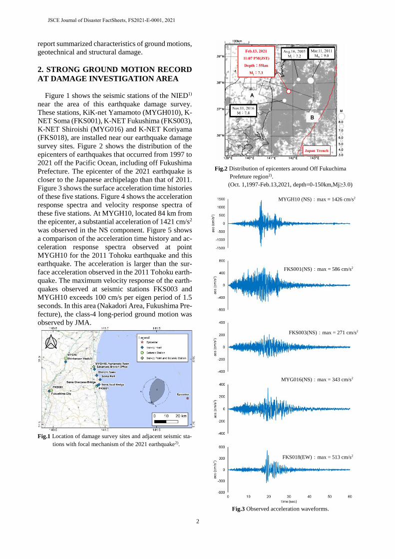
of these five stations. Figure 4 shows the acceleration
response spectra and velocity response spectra of
these five stations. At MYGH10, located 84 km from
the epicenter, a substantial acceleration of 1421 cm/s2
was observed in the NS component. Figure 5 shows
a comparison of the acceleration time history and ac-
celeration response spectra observed at point
MYGH10 for the 2011 Tohoku earthquake and this
earthquake. The acceleration is larger than the sur-
face acceleration observed in the 2011 Tohoku earth-
quake. The maximum velocity response of the earth-
quakes observed at seismic stations FKS003 and
MYGH10 exceeds 100 cm/s per eigen period of 1.5
seconds. In this area (Nakadori Area, Fukushima Pre-
fecture), the class-4 long-period ground motion was
observed by JMA.
Fig.1 Location of damage survey sites and adjacent seismic sta-
tions with focal mechanism of the 2021 earthquake2).
Fig.2 Distribution of epicenters around Off Fukuchima
Prefeture region2).
(Oct. 1,1997-Feb.13,2021, depth=0-150km,Mj≥3.0)
Fig.3 Observed acceleration waveforms.
MYGH10 (NS):max = 1426 cm/s2
FKS001(NS):max = 586 cm/s2
FKS003(NS):max = 271 cm/s2
MYG016(NS):max = 343 cm/s2
FKS018(EW):max = 513 cm/s2
JSCE Journal of Disaster FactSheets, FS2021-E-0001, 2021
3
(a) Acceleration response spectra Sa(h=0.05).
(b) Velocity response spectra Sv(h=0.05)
Fig.4 Response spectra Sa and Sv.
(a) Observed acceleration waveforms.
(b) Acceleration response spectra Sa(h=0.05)
Fig.5 Comparison of the 2021 earthquake and the 2011 Tohoku
Earthquake observed at MYGH10.
3. GEOTECHNICAL DAMAGE
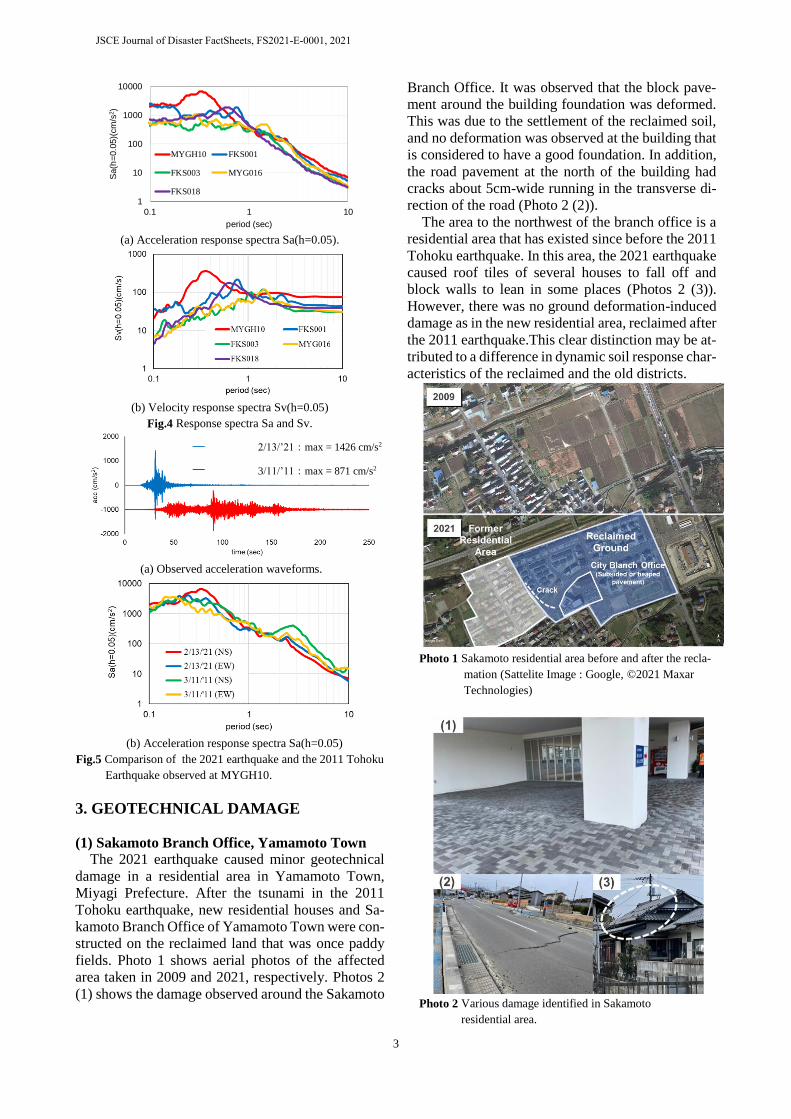
(1) Sakamoto Branch Office, Yamamoto Town
The 2021 earthquake caused minor geotechnical
damage in a residential area in Yamamoto Town,
Miyagi Prefecture. After the tsunami in the 2011
Tohoku earthquake, new residential houses and Sa-
kamoto Branch Office of Yamamoto Town were con-
structed on the reclaimed land that was once paddy
fields. Photo 1 shows aerial photos of the affected
area taken in 2009 and 2021, respectively. Photos 2
(1) shows the damage observed around the Sakamoto
Branch Office. It was observed that the block pave-
ment around the building foundation was deformed.
This was due to the settlement of the reclaimed soil,
and no deformation was observed at the building that
is considered to have a good foundation. In addition,
the road pavement at the north of the building had
cracks about 5cm-wide running in the transverse di-
rection of the road (Photo 2 (2)).
The area to the northwest of the branch office is a
residential area that has existed since before the 2011
Tohoku earthquake. In this area, the 2021 earthquake
caused roof tiles of several houses to fall off and
block walls to lean in some places (Photos 2 (3)).
However, there was no ground deformation-induced
damage as in the new residential area, reclaimed after
the 2011 earthquake.This clear distinction may be at-
tributed to a difference in dynamic soil response char-
acteristics of the reclaimed and the old districts.
Photo 1 Sakamoto residential area before and after the recla-
mation (Sattelite Image : Google, ©2021 Maxar
Technologies)
Photo 2 Various damage identified in Sakamoto
residential area.
1
10
100
1000
10000
0.1 1 10
Sa(h
=0.0
5)(
cm
/s2)
period (sec)
MYGH10 FKS001
FKS003 MYG016
FKS018
2/13/’21:max = 1426 cm/s2
3/11/’11:max = 871 cm/s2
JSCE Journal of Disaster FactSheets, FS2021-E-0001, 2021
4
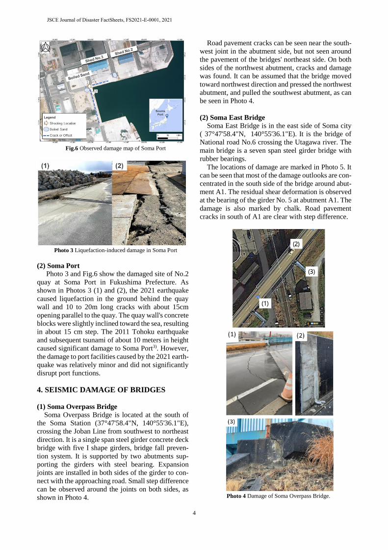
Fig.6 Observed damage map of Soma Port
Photo 3 Liquefaction-induced damage in Soma Port
(2) Soma Port Photo 3 and Fig.6 show the damaged site of No.2
quay at Soma Port in Fukushima Prefecture. As
shown in Photos 3 (1) and (2), the 2021 earthquake
caused liquefaction in the ground behind the quay
wall and 10 to 20m long cracks with about 15cm
opening parallel to the quay. The quay wall's concrete
blocks were slightly inclined toward the sea, resulting
in about 15 cm step. The 2011 Tohoku earthquake
and subsequent tsunami of about 10 meters in height
caused significant damage to Soma Port3). However,
the damage to port facilities caused by the 2021 earth-
quake was relatively minor and did not significantly
disrupt port functions.
4. SEISMIC DAMAGE OF BRIDGES
(1) Soma Overpass Bridge
Soma Overpass Bridge is located at the south of
the Soma Station (37°47'58.4"N, 140°55'36.1"E),
crossing the Joban Line from southwest to northeast
direction. It is a single span steel girder concrete deck
bridge with five I shape girders, bridge fall preven-
tion system. It is supported by two abutments sup-
porting the girders with steel bearing. Expansion
joints are installed in both sides of the girder to con-
nect with the approaching road. Small step difference
can be observed around the joints on both sides, as
shown in Photo 4.
Road pavement cracks can be seen near the south-
west joint in the abutment side, but not seen around
the pavement of the bridges' northeast side. On both
sides of the northwest abutment, cracks and damage
was found. It can be assumed that the bridge moved
toward northwest direction and pressed the northwest
abutment, and pulled the southwest abutment, as can
be seen in Photo 4.
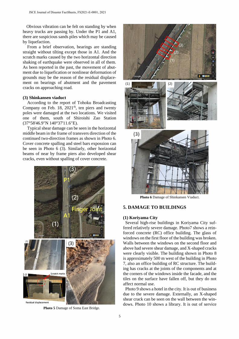
(2) Soma East Bridge
Soma East Bridge is in the east side of Soma city
( 37°47'58.4"N, 140°55'36.1"E). It is the bridge of
National road No.6 crossing the Utagawa river. The
main bridge is a seven span steel girder bridge with
rubber bearings.
The locations of damage are marked in Photo 5. It
can be seen that most of the damage outlooks are con-
centrated in the south side of the bridge around abut-
ment A1. The residual shear deformation is observed
at the bearing of the girder No. 5 at abutment A1. The
damage is also marked by chalk. Road pavement
cracks in south of A1 are clear with step difference.
Photo 4 Damage of Soma Overpass Bridge.
JSCE Journal of Disaster FactSheets, FS2021-E-0001, 2021
5
Obvious vibration can be felt on standing by when
heavy trucks are passing by. Under the P1 and A1,
there are suspicious sands piles which may be caused
by liquefaction.
From a brief observation, bearings are standing
straight without tilting except those in A1. And the
scratch marks caused by the two horizontal direction
shaking of earthquake were observed in all of them.
As been reported in the past, the movement of abut-
ment due to liquefication or nonlinear deformation of
grounds may be the reason of the residual displace-
ment on bearings of abutment and the pavement
cracks on approaching road.
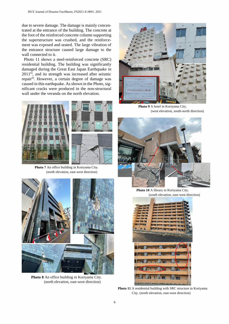
(3) Shinkansen viaduct
According to the report of Tohoku Broadcasting
Company on Feb. 18, 20214), ten piers and twenty
poles were damaged at the two locations. We visited
one of them, south of Shiroishi Zao Station
(37°58'46.9"N 140°37'11.6"E).
Typical shear damage can be seen in the horizontal
middle beam in the frame of transvers direction of the
continued two-direction frames as shown in Photo 6.
Cover concrete spalling and steel bars expossion can
be seen in Photo 6 (3). Similarly, other horizontal
beams of near by frame piers also developed shear
cracks, even without spalling of cover concrete.
Photo 5 Damage of Soma East Bridge.
Photo 6 Damage of Shinkansen Viaduct.
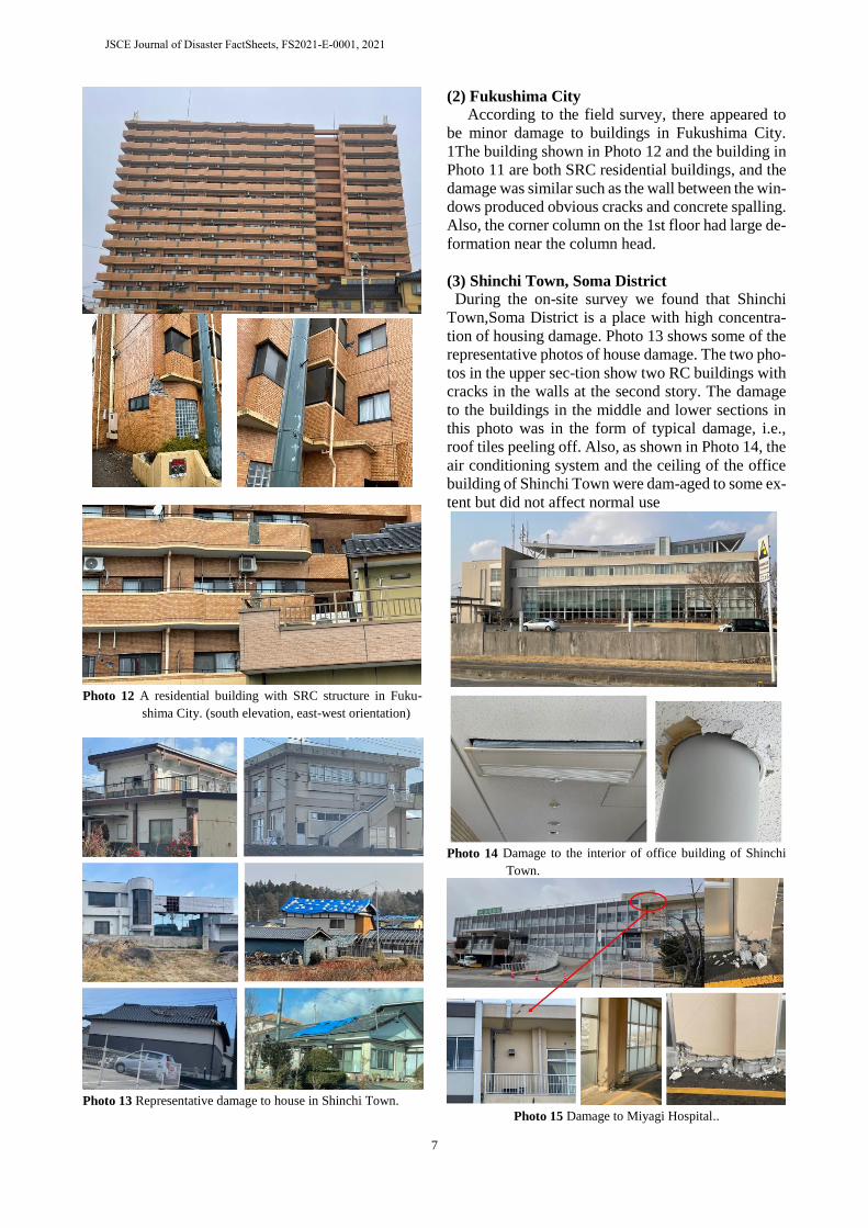
5. DAMAGE TO BUILDINGS
(1) Koriyama City
Several high-rise buildings in Koriyama City suf-
fered relatively severe damage. Photo7 shows a rein-
forced concrete (RC) office building. The glass of
windows on the first floor of the building was broken.
Walls between the windows on the second floor and
above had severe shear damage, and X-shaped cracks
were clearly visible. The building shown in Photo 8
is approximately 500 m west of the building in Photo
7, also an office building of RC structure. The build-
ing has cracks at the joints of the components and at
the corners of the windows inside the facade, and the
tiles on the surface have fallen off, but they do not
affect normal use.
Photo 9 shows a hotel in the city. It is out of business
due to the severe damage. Externally, an X-shaped
shear crack can be seen on the wall between the win-
dows. Photo 10 shows a library. It is out of service
JSCE Journal of Disaster FactSheets, FS2021-E-0001, 2021
6
due to severe damage. The damage is mainly concen-
trated at the entrance of the building. The concrete at
the foot of the reinforced concrete column supporting
the superstructure was crushed, and the reinforce-
ment was exposed and seated. The large vibration of
the entrance structure caused large damage to the
wall connected to it.
Photo 11 shows a steel-reinforced concrete (SRC)
residential building. The building was significantly
damaged during the Great East Japan Earthquake in
20116), and its strength was increased after seismic
repair6). However, a certain degree of damage was
caused in this earthquake. As shown in the Photo, sig-
nificant cracks were produced in the non-structural
wall under the veranda on the north elevation.
Photo 7 An office building in Koriyama City.
(north elevation, east-west direction)
Photo 8 An office building in Koriyama City.
(north elevation, east-west direction)
Photo 9 A hotel in Koriyama City.
(west elevation, south-north direction)
Photo 10 A library in Koriyama City.
(south elevation, east-west direction)
Photo 11 A residential building with SRC structure in Koriyama
City. (north elevation, east-west direction)
JSCE Journal of Disaster FactSheets, FS2021-E-0001, 2021
7
Photo 12 A residential building with SRC structure in Fuku-
shima City. (south elevation, east-west orientation)
Photo 13 Representative damage to house in Shinchi Town.
(2) Fukushima City
According to the field survey, there appeared to
be minor damage to buildings in Fukushima City.
1The building shown in Photo 12 and the building in
Photo 11 are both SRC residential buildings, and the
damage was similar such as the wall between the win-
dows produced obvious cracks and concrete spalling.
Also, the corner column on the 1st floor had large de-
formation near the column head.
(3) Shinchi Town, Soma District
During the on-site survey we found that Shinchi
Town,Soma District is a place with high concentra-
tion of housing damage. Photo 13 shows some of the
representative photos of house damage. The two pho-
tos in the upper sec-tion show two RC buildings with
cracks in the walls at the second story. The damage
to the buildings in the middle and lower sections in
this photo was in the form of typical damage, i.e.,
roof tiles peeling off. Also, as shown in Photo 14, the
air conditioning system and the ceiling of the office
building of Shinchi Town were dam-aged to some ex-
tent but did not affect normal use
Photo 14 Damage to the interior of office building of Shinchi
Town.
Photo 15 Damage to Miyagi Hospital..
JSCE Journal of Disaster FactSheets, FS2021-E-0001, 2021
8
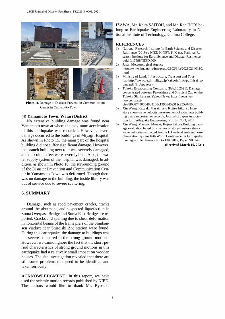
Photo 16 Damage to Disaster Prevention Communication
Center in Yamamoto Town
(4) Yamamoto Town, Watari District
No extensive building damage was found near
Yamamoto town at where the maximum acceleration
of this earthquake was recorded. However, severe
damage occurred to the buildings of Miyagi Hospital.
As shown in Photo 15, the main part of the hospital
building did not suffer significant damage. However,
the branch building next to it was severely damaged,
and the column feet were severely bent. Also, the wa-
ter supply system of the hospital was damaged. In ad-
dition, as shown in Photo 16, the surrounding ground
of the Disaster Prevention and Communication Cen-
ter in Yamamoto Town was deformed. Though there
was no damage to the building, the inside library was
out of service due to severe scattering.
6. SUMMARY
Damage, such as road pavement cracks, cracks
around the abutment, and suspected liquefaction in
Soma Overpass Bridge and Soma East Bridge are re-
ported. Cracks and spalling due to shear deformation
in horizontal beams of the frame piers of the Shinkan-
sen viaduct near Shiroishi Zao station were found.
During this earthquake, the damage to buildings was
not severe compared to the strong ground motions.
However, we cannot ignore the fact that the short-pe-
riod characteristics of strong ground motions in this
earthquake had a relatively small impact on wooden
houses. The site investigation revealed that there are
still some problems that need to be identified and
taken seriously.
ACKNOWLEDGMENT: In this report, we have
used the seismic motion records published by NIED.
The authors would like to thank Mr. Ryosuke
IZAWA, Mr. Keita SAITOH, and Mr. Ren HORI be-
long to Earthquake Engineering Laboratory in Na-
tional Institute of Technology, Gunma College.
REFERENCES 1) National Research Institute for Earth Science and Disaster
Resilience (2019):NIED K-NET, KiK-net, National Re-
search Institute for Earth Science and Disaster Resilience,
doi:10.17598/NIED.0004
2) Japan Meteorological Agency:
https://www.jma.go.jp/jma/press/2102/14a/202102140110.
html
3) Ministry of Land, Infrastructure, Transport and Tour-
ism:http://www.pa.thr.mlit.go.jp/kakyoin/info/pdf/hisai_so
uma.pdf (in Japanese)
4) Tohoku Broadcasting Company. (Feb.18.2021). Damage
concentrated between Fukushima and Shiroishi Zao on the
Tohoku Shinkansen. Yahoo News: https://news.ya-
hoo.co.jp/arti-
cles/ff6c6748083d8d8130c1990d46e312c255e04f0d
5) Xin Wang, Kazuaki Masaki, and Kojiro Irikura : Inter-
story shear-wave velocity measurement of a damage build-
ing using microtremor records, Journal of Japan Associa-
tion for Earthquake Engineering, Vol.14, No.3, 2014.
6) Xin Wang, Mazuaki Masaki, Kojiro Irikura:Building dam-
age evaluation based on changes of story-by-story shear-
wave velocities extracted from a 1D vertical ambient noise
observation system,16th World Conference on Earthquake,
Santiago Chile, January 9th to 13th 2017, Paper N0. 749.
(Received March 16, 2021)
JSCE Journal of Disaster FactSheets, FS2021-E-0001, 2021