Embed Size (px)
Citation preview
Nagra Nationale Genossenschaft fOr die Lagerung radioaktiver Abfalle
Cedra Societe cooperative nationale pour I'entreposage de dechets radioactifs
Cisra Societa cooperativa nazionale per I'immagazzinamento di scorie radioattive
TECHNISCHER BERICHT 85-53
THE EASTERN JURA: RELATIONS BETWEEN THIN-SKINNED AND BASEMENT TECTONICS, LOCAL AND REGIONAL
H. P. LAUBSCHER OKTOBER 1985
GEOLOGISCH-PALAONTOLOGISCHES INSTITUT DER UNIVERSITAT BASEL
Parkstrasse 23 5401 Baden 1 Schweiz Telephon 056/205511
Die vor1iegende Arbeit liefert einen wichtigen Beitrag
zum Verstandnis der geologisch-tektonischen Verhaltnisse
in der Nordschweiz. Hierzu haben die in den Jahren 1980
bis 1984 durchgeflihrten geophysikalischen Messungen und
Tiefbohrungen der Nagra wesentliche neue Informationen
beigetragen.
Die Arbeit wird gleichzeitig in der Festschrift zum
100. Geburtstag von H. Cloos in der Geologischen Rund
schau, Band 75, Heft 3, 1986 publiziert.
Der Autor hat seine eigenen Ansichten und Schlussfolgerungen
dargestellt. Diese mlissen nicht unbedingt mit denjenigen der
Nagra libereinstimrnen.
This report makes an important contribution to the eluci
dation of the geological structure of Northern Switzerland.
Results of Nagra's geophysical surveys and exploratory
boreholes, executed from 1980 to 1984, have contributet
critical new information.
This paper is being presented at the same time in the issue
of Geologische Rundschau celebrating the 100th birthday
anniversary of H. Cloos (Geologische Rundschau, Vol. 75,
No.3, 1986).
The viewpoints presented and conclusions reached are
those of the author and do not necessarily represent those
of Nagra.
NAGRA NTB 85-53 - I -
ABSTRACT
The thesis area of Hans Cloos in the eastern Jura straddles the boundary between the Paleogene structures of the Tabular Jura, a part of the southeastern end of the Rhine graben, and the Neogene folds and thrusts of the Folded Jura. A recent reflection seismic survey in the area adjacent to the east provides new information on the subsurface structure and the relation between three superposed tectonic events. The main boundary fault zones of a deep and complexly faulted late Paleozoic trough, trending ENE, were reactivated in the early Tertiary. Faulted flexures and small folds, rooted in the basement and Paleozoic, with an amplitude of usually 100 to 300 m were produced, rather than the normal faults typical for the extensional fields of the Rhine-Bresse graben system in the west and the Bavarian Molasse basin in the east. This suggests their being part of a transform zone between these extensional fields. During Jura decollement in the Neogene these inherited, deeply rooted sub-decollement structures remained passive: their small size is kinematically incompatible with the intense subsequent thrusting and folding of the thin Mesozoic-Tertiary skin. However, thrust ramps were apparently nucleated at the respective southern foot of these Paleogene flexures and folds. The best defined and simplest of these composite structures is the Mandach structure within the Tabular Jura, a south-facing flexure of about 300 m relief, developed in the Paleogene by reactivation of the northern border fault zone of the Paleozoic trough. In the Neogene a north-vergent decollement thrust, which is connected with the regional Jura decollement in the middle Triassic evaporites, was initiated at its site. The southernmost nucleation point at the southern limit of the folded Jura was apparently re-used after intervals of northward spreading of decollement. There is evidence that a similar succession of events took place in the central and western Jura as well. Regionally, the boundary faults of at least some of the Paleozoic troughs were reactivated in the early Tertiary as transform zones linking the Rhine-Bresse-Rhone graben systems, while these early Tertiary tectonics in turn provided important boundary conditions for Jura decollement, Which is the result of northward propagation of the Europa-Africa collision zone in the Neogene.
NAGRA NTB 85-53 - II -
ZUSAMMENFASSUNG
Das Dissertationsgebiet von Hans Cloos im ostlichen Jura liegt im Grenzbezirk zwischen den untertertiaren Strukturen des Tafeljuras, einem Teil des Slidostendes des Rheingrabens und den neogenen Falten und Ueberschiebungen des Faltenjuras. In jlingster Zeit wurden reflexionsseismische Aufnahmen von ausgezeichneter Qualitat im ostlich anschliessenden Gebiet durchgefUhrt. Sie forderten kritische neue Information zutage Uber die Untergrundstruktur und die Beziehungen zwischen drei aufeinanderfolgenden tektonischen Ereignissen. Das alteste ist dokumentiert in einem mehrere Kilometer tiefen und komplex zerbrochenen und gefalteten spatpalaozoischen Trog, der ungefahr ENE streicht. Seine wichtigsten Randbruchzonen wurden im Untertertiar reaktiviert, und zwar entstanden leicht zerbrochene Flexuren und kleine Falten, die in der Tiefe wurzeln und eine Ampli tude von ungefahr 100 - 300 Meter erreichen. Dieser tektonische Stil steht im Gegensatz zu den gleichaltrigen Dehnungsfeldern sowohl im \'lesten (Rhein-Bresse Grabensystem) wie auch im Osten (Bruchsysteme des bayrischen Molassebeckens). Daraus mochte man schliessen, dass das Untersuchungsgebiet in einer vermittelnden Transforrnzone liegt. vlahrend der neogenen JuraAbscherung tiber den Trias-Evaporiten blieben diese kleinen Strukturen passiv: ihre geringe Grosse ist kinematisch inkompatibel mit der intensiven Ueberschiebungs- und Faltentektonik der abgescherten Sedimenthaut. Andererseits wurden nach der seismischen Evidenz an ihrem jeweiligen Slidfuss Ueberschiebungsrampen nukleiert. Die am besten definierte und einfachste dieser zusammengesetzten Strukturen ist die Mandach-Struktur im Tafeljura, eine nach Sliden blickende Flexur von etwa 300 Metern Hohe. Sie entstand im Palaogen durch Reaktivierung der nordlichen Randbruchzone des palaozoischen Troges. Die Datierung als Palaogen gelingt in der ostlichen Fortsetzung. 1m Neogen entwickelte sich an dieser Flexur eine nordvergente Ueberschiebung, die gegen Sliden in die allgemeine Abscherung des Juras Uber den Evaporiten der mittleren Trias Ubergeht. Der sUdlichste Nukleationspunkt fUr Ueberschiebungen am Sudfuss des Juras wurde offenbar wiederholt aktiviert nach Intervallen, in denen sich die Abscherung nach Norden ausbreitete. Er konnte als eine Art IIUeberschiebungsmUhle li bezeichnet werden. Es gibt mancherlei Anzeichen flir eine ahnliche Reihenfolge der Ereignisse im zentralen und westlichen Jura. Regional gesehen wurden besonders die Randstorungen wenigstens einiger der palaozoischen Troge im Palaogen reaktiviert, und zwar hauptsachlich als Transforrnzonen im Rhein-Bresse-Rhone-Graben-System. Andererseits lieferte diese untertertiare Tektonik wesentliche Randbedingungen fUr die neogene Jura-Abscherung, die Front der sich gegen Norden ausbreitenden Kollisionszone zwischen Europa und Afrika.
NAGRA NTB 85-53 - III -
RESUME
La region etudiee par Hans Cloos au cours de sa these se situe entre les structures paleogenes du Jura tabulaire - une partie de l'extremite sud-est du fosse rhenan - et les plissements et charriages neogenes du Jura plisse. Une recente campagne sismique de reflexion dans la region adjacente nous a donne des informations detaillees sur la structure du soubassement characterisee par trois evenements tectoniques superposes: Le plus ancien est represente par un fosse en direction ENE, rempli de plusieurs kilometres de sediments du paleozoique tardif et borde par un systeme camplexe de failles. Ces failles marginales furent reactivees au tertiaire inferieur produisant des flexures fracturees et des petits plis d'une amplitude de 100 a 300 metres, enracinees profondemment. C'est done un style tectonique divergent des failles normales des fosses rhenan et bressan a l'ouest et du bassin mOlassique bavarois a l'est, tous datant du tertiaire inferieur. Les structures observees semblent correspondre a une zone de transformation entre ces deux zones d'extension. Pendant Ie decollement du Jura au neogene ces structures profondes deja tectoni sees au paleogene se trouverent en dessous de l'horizon de decollement et resterent passives. Du point de vue cinematique leur dimension reduite est incompatible avec la tectonique intensive de plissement et de charriage de la couverture mesozoique. Par contre les charriages prirent naissance au pied meridional de ces flexures et plis paleogenes. La flexure la mieux definie et egalement la plus simple de ces structures composees, est la structure de Mandach dans Ie Jura tabulaire. Cette flexure au regard sud, d'un rejet d'environ 300 metres, fut generee au paleogene par la reactivation du systeme de failles de la bordure nord du fosse paleozoique. C1est au pied meridional de cette flexure, dans les evaporites du trias moyen, qulun plan de chevauchement de vergence nord se developpa lors du decollement neogene du Jura plisse. En ce qui concerne les points d'origine des charriages plus meridionaux, ils furent reactives plusieures fois suivant les intervals du decollement progressant vers le nord. Une succession similaire dans les parties centrales et occidentales du Jura semble possible. Du point de vue regional les failles de plusieurs fosses paleozoiques furent reactivees au paleogene, essentiellement comme zones de transformation dans Ie systeme paleogene des fosses rhenan, bressan et rhodanien. A son tour cette tectonique du tertiaire inferieur posa des conditions importantes pour Ie decollement du Jura, lui meme resultat de la propagation vers Ie nord de la zone de collision entre l'Europe et l'Afrique au neogene.
NAGRA NTB 85-53 - IV -
TABLE OF CONTENTS
ABSTRACT ZUSAMMENF AS SUNG RESUME
TABLE OF CONTENTS LIST OF FIGURES
1
2
3
3.1
3.2
3.3
3.4
4
INTRODUCTION
THE REGIONAL PICTURE
DETAILS OF THE SEQUENCE OF DEFORMATION IN THE EASTERN JURA
The Mandach Structure
The sub-decollement relief
Folds and thrusts of the easternmost Jura: geometry and relation to sub-decollement structure
The nucleation of supra-decollement thrusts
INDICATIONS OF PALEOGENE IRREGULARITIES
Page
I II
III
IV V
1
3
7
10
13
17
20
IN THE DECOLLEMENT SURFACE WEST OF FIGURE 3 24
5 CONCLUSIONS 26
6 BIBLIOGRAPHY 27

NAGRA NTB 85-53 - V -
LIST OF FIGURES
Figure 1=
Figure 2:
Figure 3:
Figure 4:
Figure 5:
Figure 6:
Figure 7:
Figure 8:
Late Paleozoic (as far as known) and early Tertiary troughs and grabens of the Rhine-Rhone system and surroundings, simplified.
The relation of the Neogene Alpine front (Jura) to Paleogene and Paleozoic structures.
Location of seismic lines in the easternmost Jur a and its foreland.
Two seismic profiles through the Mandach structure.
Figure 4 without interpretation.
Time sections, migrated. Basal Triassic (sub-decollement), Paleogene relief.
The sections of Figure 6, simplified, showing the main structures and their interference.
Reflection time contours on basal Triassic Buntsandstein.
Figure 9: The same as Figure 8, greatly simplified, showing the main structures and their interference.
Figure 10: The relation of the main decollement structures to sub-decollement relief on Lines 10, 30, 60.
Figure 11: Three models for thrust (dot-dash) nucleation at sub-decollement structures.
Figure 12: A qualitative model of successive thrust nucleation in the course of decollement in the eastern Jura.
NAGRA NTB 85-53 - 1 -
1 INTRODUCTION
In his dissertation about an area straddling the boundary between the Paleogene *) structures of the Tabular Jura and the Neogene structures of the Folded Jura, Hans Cloos (1910) discussed the relation between basement tectonics and the various manifestations of thin-skinned tectonics above the decollement layer of the middle Triassic. At that time, Buxtorf's (1907) first version of the decollement ("Fernschub") model for the folded Jura had just been published, and the detailed implications had not been worked out. Cloos was one of the very first tackling this problem. He realized that the Paleogene normal faults of the Tabular Jura were sometimes rooted in the pre-Mesozoic, and sometimes in the middle Triassic and in this case were probably decollement features. Hhere penetrating into the domain of the later (Neogene) folded Jura, they were apparently reactivated in various ways, and in some instances rather passively incorporated into the Neogene thrust and fold tectonics. He accepted the "Mont Terrible-flexure" of Buxtorf (1907) as the most fundamental deep-seated structure which gave rise to the marginal thrust of the Jura in the area.
In the subsequent three quarters of this century, these relations were debated by several authors, and much new evidence has come to light. I have, for the last 25 years, been involved in field work and tectonic analysis of extensive parts of the eastern Jura, including Cloos's dissertation area. However, the most recent and most revealing information has been contributed by the geophysical surveys and the drillholes of Nagra (1985), in the easternmost part of the eastern Jura. The reflection seismic lines are of very high quality and permit a new insight into the relations between basement and decollement tectonics; formerly, one had of necessity to be content with models obtained by extrapolation of surface data and tunnel information (e.g. Laubscher, 1977, 1981). I had the privilege of being allowed to spend much time on the interpretation of these seismic lines, and a good deal of my argumentation rests on their evidence. I shall first sketch the regional picture,
*) In This article "Paleogene" stands for "pre-Upper tv1arine Molasse" and possibly includes a part of the Aqui tanien.
NAGRA NTB 85- 5 3 - 2 -
then present in detail the seismic evidence for those events that bear on the thesis of this article, and finally briefly assess the importance of the new information for the rest of the Jura and its surroundings.
o I
200Km
I
x
~ Tertiary normal faults
xxxx II Transform zones
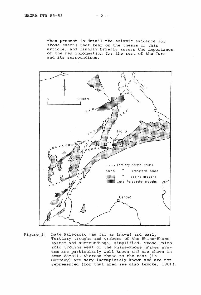
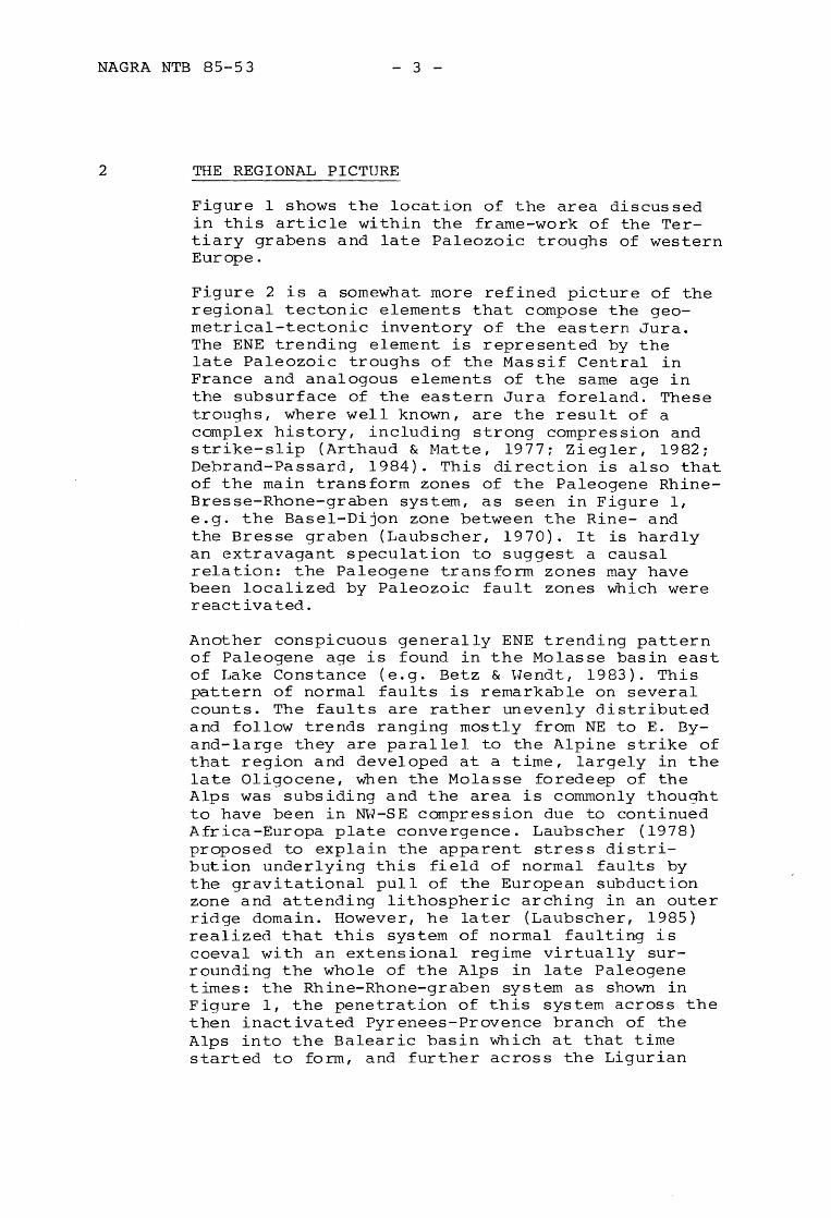
Figure 1: Late Paleozoic (as far as known) and early Tertiary troughs and grabens of the Rhine-Rhone system and surroundings, simplified. Those Paleozoic troughs west of the Rhine-Rhone graben system are particularly well known and are shown in some detail, whereas those to the east (in Germany) are very incompletely known and are not represented (for that area see also Lemcke, 1981).
NAGRA NTB 85-53 - 3 -
2 THE REGIONAL PICTURE
Figure I shows the location of the area discussed in this article within the frame-work of the Tertiary grabens and late Paleozoic troughs of western Europe.
Figure 2 is a somewhat more refined picture of the regional tectonic elements that compose the geometrical-tectonic inventory of the eastern Jura. The ENE trending element is represented by the late Paleozoic troughs of the Massif Central in France and analogous elements of the same age in the subsurface of the eastern Jura foreland. These troughs, where well known, are the result of a complex history, including strong compression and strike-slip (Arthaud & Matte, 1977; Ziegler, 1982; Debrand-Passard, 1984). This direction is also that of the main transform zones of the Paleogene RhineBresse-Rhone-graben system, as seen in Figure 1, e.g. the Basel-Dijon zone between the Rine- and the Bresse graben (Laubscher, 1970). It is hardly an extravagant speculation to suggest a causal relation: the Paleogene transform zones may have been localized by Paleozoic fault zones which were reactivated.
Another conspicuous generally ENE trending pattern of Paleogene age is found in the Molasse basin east of Lake Constance (e.g. Betz & Hendt, 1983). This pattern of normal faults is remarkable on several counts. The faults are rather unevenly distributed and follow trends ranging mostly from NE to E. Byand-large they are parallel to the Alpine strike of that region and developed at a time, largely in the late Oligocene, When the Molasse foredeep of the Alps was subsiding and the area is commonly thought to have been in NH-SE compression due to continued Africa-Europa plate convergence. Laubscher (1978) proposed to explain the apparent stress distribution underlying this field of normal faults by the gravitational pull of the European subduction zone and attending lithospheric arching in an outer ridge domain. However, he later (Laubscher, 1985) realized that this system of normal faulting is coeval with an extensional regime virtually surrounding the whole of the Alps in late Paleogene times: the Rhine-Rhone-graben system as shown in Figure 1, the penetration of this system across the then inactivated Pyrenees-Provence branch of the Alps into the Balearic basin which at that time started to form, and further across the Ligurian
NAGRA NTB 85-53 - 4 -
Alps into the Southern Alps. Apparently large-scale decoupling by roll-back of subduction took place at that time, comparable to Aegean or Tyrrhenian backarc spreading nowadays (e.g. Angelier & Le Pichon, 1980). Hhile there is compelling evidence for a regional crustal extension in the later part of the Paleogene, the change of direction between the Bavarian Molasse- and the Rhinegraben fault systems calls for a special explanation. Accepting the strike of the normal faults as the direction of the sigma 2 trajectories, one is forced to postulate a change in the geometry of the stress field somewhere in the area between Lake Constance and Basel. The geometry of the eastern part is still most plausibly attributed to the gravity pull of the European subduction zone, whereas the Rhine-Rhonegraben system, being in the farther foreland, might conveniently be attributed to asthenospheric convection. As Hans Cloos (1939) had already pointed out in his famous essay on "Hebung-Spaltung-Vulkanismus", the Rhinegraben developed in the cen tral part of a domal uplift which can hardly be anything but thermally activated. Thus there is good reason to cons ide r a fundamental change of condi tions at the lower crustal boundary between the two regions. Without going into further details it is evident from Figures 1 and 2 that the eastern Jura and its foreland are at the junction of the two Paleogene stress fields, and this has to be borne in mind when assessing its structural elements.
Among many structures the southeastern end of the Rhinegraben appears to be affected by this situation. Hhile Cloos (1939) called attention to the branching of the Rhinegraben at its southern end and its opening "in the form of a trumpet", putting it forth as one example of an universal rule (also compare Laubscher, 1970~ Withjack & Scheiner, 1982), our present interest focusses on the fact that this branching is strongly asymmetrical. According to the foregoing discussion we tentatively attribute this asymmetry to the presence of inhomogeneities inherited from the late Paleozoic, as well as to the transition between two Paleogene stress fields of different causation.
This was the structural framework encountered by the "Miocene revolution" (Laubscher, 1985), when decoupling between the Africa and Europa plates and extension stopped and the Alpine domain again became a main suture of plate collision. At that time, important compressional features were added both north and south of the Alps, and among them,
NAGRA NTB 85-53
<}--z--
Figure 2:
5
c: .g (/) 0)
5. E 8
,..---J\----.
""0 ,!g .~
""0 ........... -0 0) 0) ]5 (/) 0 o .D 0. 0 ~ 5.
II
-0 ""0 c: c: 0 o ...... o
c 0) u o :0 o
-0 c: o
c: 0)
E ~ "0 u
'0) -0
.... 0)
r-
c 0)
E 0) (/)
o .D
(/)
:::l o
2 ·c o -e o (.)
0)
:2 I
0)
0..
n mn ~ LJ llill [ill]
\
\
~ o Q
o LO
o
\
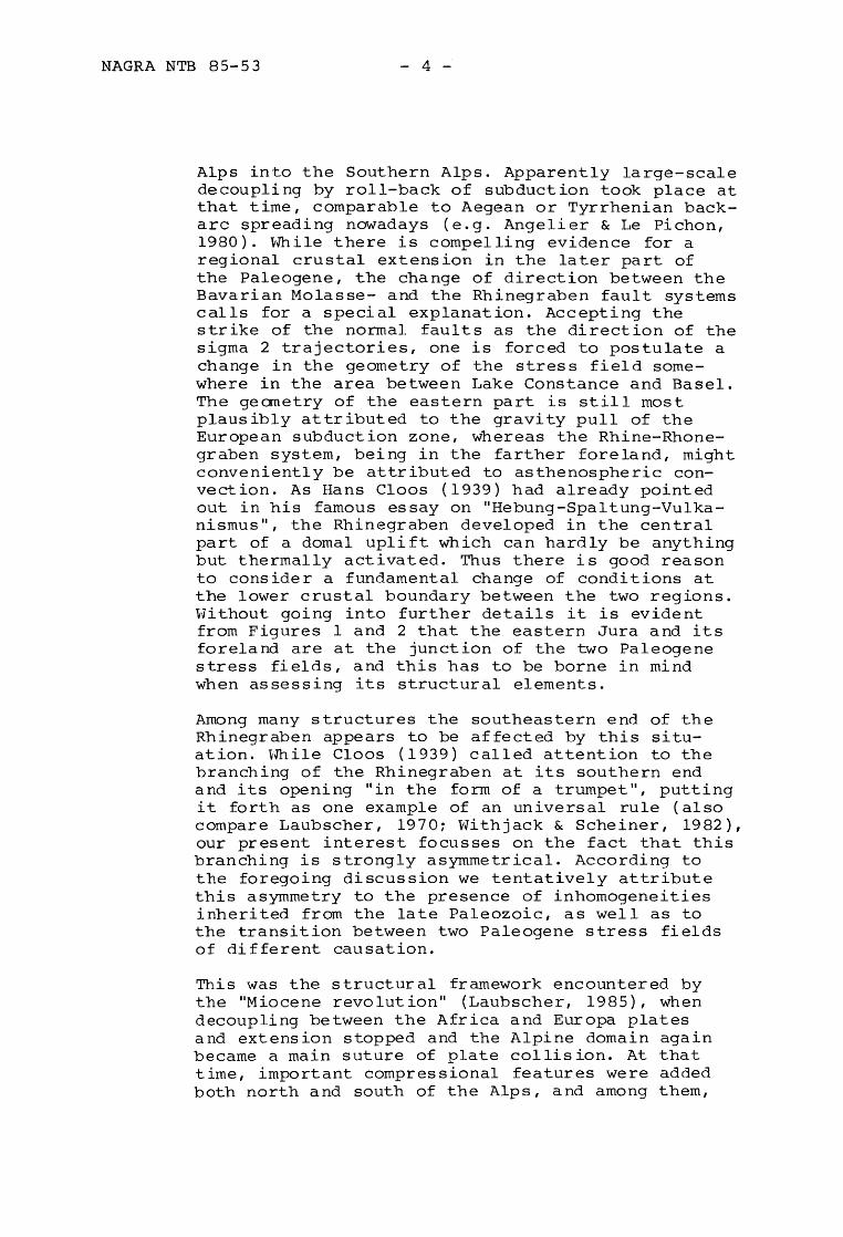
The relation of the Neogene Alpine front (Jura) to Paleogene and Paleozoic structures. The shading denotes Tertiary cover and generally exceeds the Paleogene depressions. Some known occurrences of Paleozoic are omitted, particularly those found by isola ted dr illholes.
.s:::. u c: 0)
~ -0 0)
"0 ·u o (/) (/)
o
\
\
\
NAGRA NTB 85-53 - 6 -
.. --.....
--
.-..
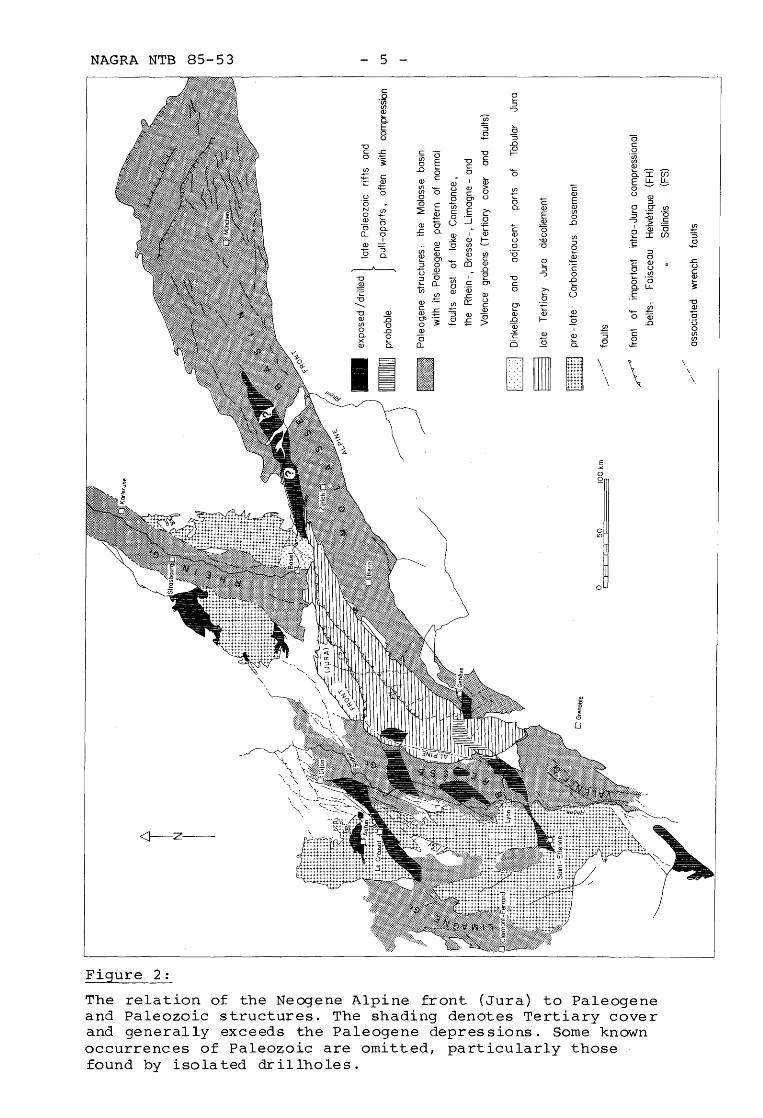
particularly relevant for the area under examination, the Jura fold and thrust system. The adaptation of the external front of the Jura to the Paleogene structures of the Rhine-Bresse-graben system is conspicuous and has been documented in great detail (e.g. Laubscher, 1981~ LefavraisRaymond, 1962). The new seismic survey now provides detailed information on an analogous relationship in the easternmost Jura.
.. ., ... . -
,'.
-
10
_<I _<1
.... . .
----
5 km
..... . . AI
60
Figure 3: Location of seismic lines in the easternmost Jura and its foreland. Dashed lines with open triangles: Mettau and Mandach thrusts; dashed line with open half-circles: Rekingen flexurei lines with black triangles: main thrusts of the folded Jurai diagonally ruled: late Paleozoic trough: Line AA' corresponds to line AA' of Figure 6.
. -.
NAGRA NTB 85-53 - 7 -
3 DETAILS OF THE SEQUENCE OF DEFORMATION IN THE EASTERN JURA
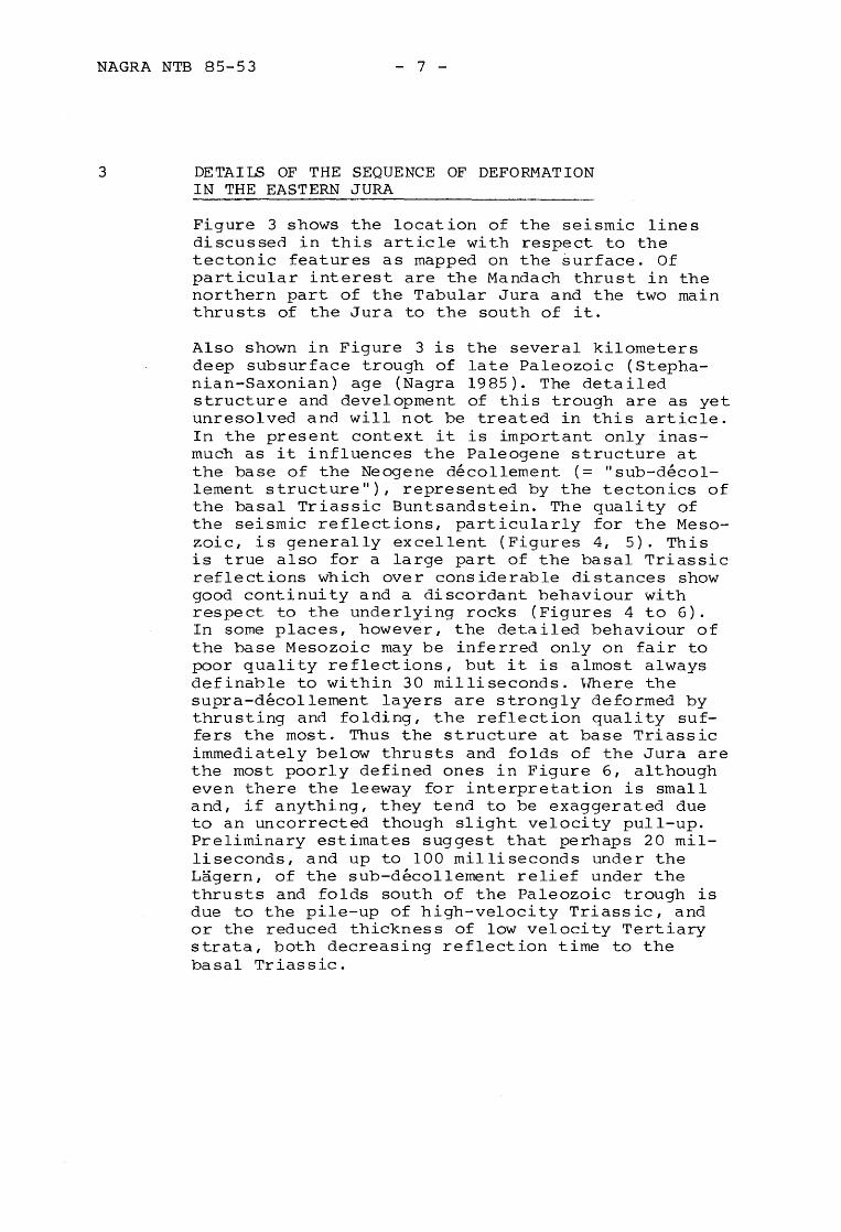
Figure 3 shows the location of the seismic lines discussed in this article with respect to the tectonic features as mapped on the surface. Of particular interest are the Mandach thrust in the northern part of the Tabular Jura and the two main thrusts of the Jura to the south of it.
Also shown in Figure 3 is the several kilometers deep subsurface trough of late Paleozoic (Stephanian-Saxonian) age (Nagra 1985). The detailed structure and development of this trough are as yet unresolved and will not be treated in this article. In the present context it is important only inasmuch as it influences the Paleogene structure at the base of the Neogene decollement (= II sub-decollement structure "), represented by the tectonics of the basal Triassic Buntsandstein. The quality of the seismic reflections, particularly for the Mesozoic, is generally excellent (Figures 4, 5). This is true also for a large part of the basal ~riassic reflections which over considerable distances show good continuity ~nd a discordant behaviour with respect to the underlying rocks (Figures 4 to 6). In some places, however, the detailed behaviour of the base Mesozoic may be inferred only on fair to poor quality reflections, but it is almost always definable to within 30 milliseconds. Hhere the supra-decollement layers are strongly deformed by thrusting and folding, the reflection quality suffers the most. Thus the structure at base Triassic immediately below thrusts and folds of the Jura are the most poorly defined ones in Figure 6, although even there the leeway for interpretation is small and, if anything, they tend to be exaggerated due to an uncorrected though slight velocity pull-up. Preliminary estimates suggest that perhaps 20 milliseconds, and up to 100 milliseconds under the Lagern, of the sub-decollement relief under the thrusts and folds south of the Paleozoic trough is due to the pile-up of high-velocity Triassic, and or the reduced thickness of low velocity Tertiary strata, both decreasing reflection time to the basal Triassic.
NAGRA NTB 85-53 - 8 -
Figure 4: Two seismic profiles through the Mandach structure. (a) Line 55, east of the Aare river (stack); (b) Line 31, west of the Aare river (migrated). For location see Figure 3. Interpreted. P = Paleozoic; U = unconformity at base of Mesozoic; M = top Muschelkalk; L = top Lias; F = Paleogene fault; dotted line = decollement and Mandach thrust; hatched: northern border fault zone of late Paleozoic trough, approximate positon.
NAGRA NTB 85-53 - 9 -
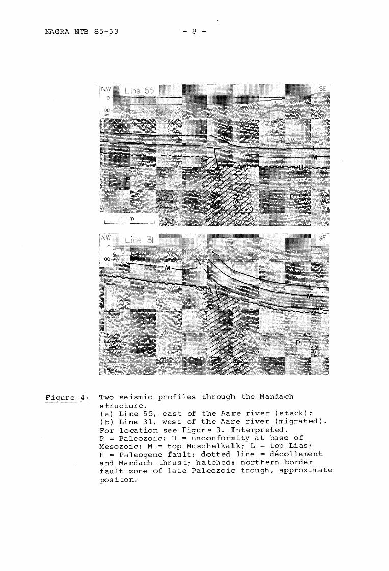
Figure 5: Figure 4 without interpretation.
NAGRA NTB 85-53 - 10 -
3.1 The Mandach Structure
Of paramount importance for some of the following arguments is the Mandach structure (Figs. 3 to 9), one of the principal features of the eastern Tabular Jura. It is mappable as a thrust at the surface (Brandlin, 1911). At depth it had been interpreted first as a basement thrust by Buxtorf (1907), and then as a decollement thrust again by Buxtorf (in Buxtorf and Niggli, 1934). One reason for the uncertainty has been its isolated occurrence in the Tabular Jura, several kilometers north of the apparent front of the folded Jura. The seismic survey now reveals that the Mandach structure consists of three superposed structures that developed at the same place at large time intervals and in response to entirely different tectonic situations. The three structures are from the top down:
1. The Neogene Mandach thrust proper, a north-vergent decollement thrust on the Middle Triassic evaporites;
2. a sub-decollement faulted flexure, down to the southi
3. the northern boundary fault zone of the deep late Paleozoic trough.
As the supra-decollement structure - the Mandach thrust - is of moderate size, the resulting distortion of the velocity distribution is slight, and the Mandach flexure is but negligibly distorted on the seismic lines (compare, e.g., Laubscher, 1956). Although it is developed above the northern border fault zone of the Paleozoic trough (Figs. 4 to 6), it is generally wider than this fault zone. It is associated with warps or small folds and is dissected by numerous small faults which are often at the limit of reliable seismic detectability. From a first inspection one is tempted to surmise that a part of the flexure might be due to differential compaction of the Paleozoic trough sediments. However, this is evidently not so: Mesozoic sedimentation is not visibly affected, implying a period of quiescence of more than 100 my following late Paleozoic diastrophism; on the other hand, differential compaction would be effective continuously as load is added. The age of the Mandach flexure and, by extension of the argument, of regional subdecollement tectonics generally, is Paleogene and thus pre-decollement (the latter is Late Miocene).
A
1 D
NW
I ~ I ~ \
-"--~-- - - _\ I.. 60 ~-'',----~ -------~ - ----c= ~----~-
2 km
----=-.-~---------.~~i,~~JD ~D F···········----~'m-h--~r~-~~ F' t
- ~ ~
~ -~':--- to., S ~- ~- ~- ~------< ~ • 40 a ~-~~>_~ __ - _ """ ~"
I --------: ~ II 31/30 L - ~~~n'-nnm~~--,-------\----f~--_---_--_-_--_
50
--~D
15 ;-=----=----. -------------
----------/~,,----- - ---------,-1'----__ _ ---.--[~-~~-~I --_h_-.·- -----------h----,--(-------r-t-------...:--.----.., ____ --.....~--"'__i_>_ _____ ,_
-- ._--10
70 i A
---------
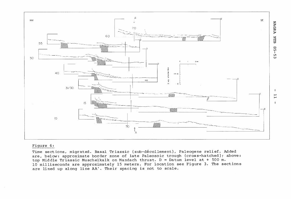
Figure 6:
Time sections, migrated. Basal Triassic (sub-decollement), Paleogene relief. Added are, below: approximate border zone of late Paleozoic trough (cross-hatched); above: top Middle Triassic Muschelkalk on Mandach thrust. D = Datum level at + 500 m. 10 milliseconds are approximately 15 meters. For location see Figure 3. The sections are lined up along line AA'. Their spacing is not to scale.
SE
---~D
D
~ G) ~ ~
Z 8 to
en U1 I
U1 W
I--' I--'
NAGRA NTB 85-53 - 12 -
This may be inferred from the situation east of the Mandach thrust which ends at the Aare river (Figure 3). From there towards the ENE a branch of the Mandach flexure continues across the Rhine (Figs. 3 to 6) and is found to be pre-Miocene (von Braun, 1953, also compare Geologische Karte der zentralen Nordschweiz l:lOO'OOOr 1984). The supradecollement Mandach-thrust (Figs. 4, 5), on the other hand, although not datable directly, has created some relief with respect to the middle Miocene Juranagelfluh and consequently is probably younger, although the irregular erosional base of the Juranagelfluh renders quantification difficult. In addition, the seismic lines in many places show decollement features linking it with the general decollement of the Jura folds and thrusts, which are definitely post-Juranagelfluh. As von Braun (1953) and others before him have pointed out, there are several indications in the area, that pre-Miocene flexures have been "reactivated" during Jura decollement. Now the seismic lines through the Mandach structure demonstrate in exemplary fashion the initial stages of a decollement thrust nucleated on top of a pre-existing sub-decollement structure, see Figures 4 and 5.
Particularly clear is the situation on Line 31. Here, the supra-decollement structure begins to deviate (ramp) from the basal decollement about 500 m south of the main break in the sub-decollement structure. This is hardly surprising. If the sub-decollement fault F in Figure 4 acted as a stress concentrator, nucleating the Mandach thrust, one of the stress concentration lobes emanating from the up-side of the fault pointed obliquely down to the south (compare Figure 11 and Laubscher, 1977). It is possible also that the change in slope at the southern foot of the flexure acted as an additional stress concentrator (see p. 21). Kinematically, the thrust had to branch off from the basal decollement zone a few hundred meters south of the fault in order to climb on the up-thrown block. Below the thrust a small supra-decollement fold may be recognized on the up-side of the normal fault. In may have developed at the leading edge of the thrust. Figure 6 shows that on all the lines the sub-decollement Mandach structure is a faulted flexure, the faults being generally small, rather than a big fault step. Evidently no large fault steps were necessary for nucleating decollement thrusts and faults; possibly breaks in slope, changes of curvature, were often sufficient for the required stress concentrations.
NAGRA NTB 85-53 - 13 -
3.2 The sub-decollement relief
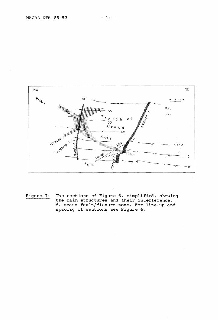
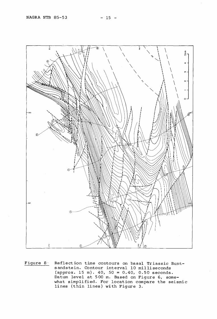
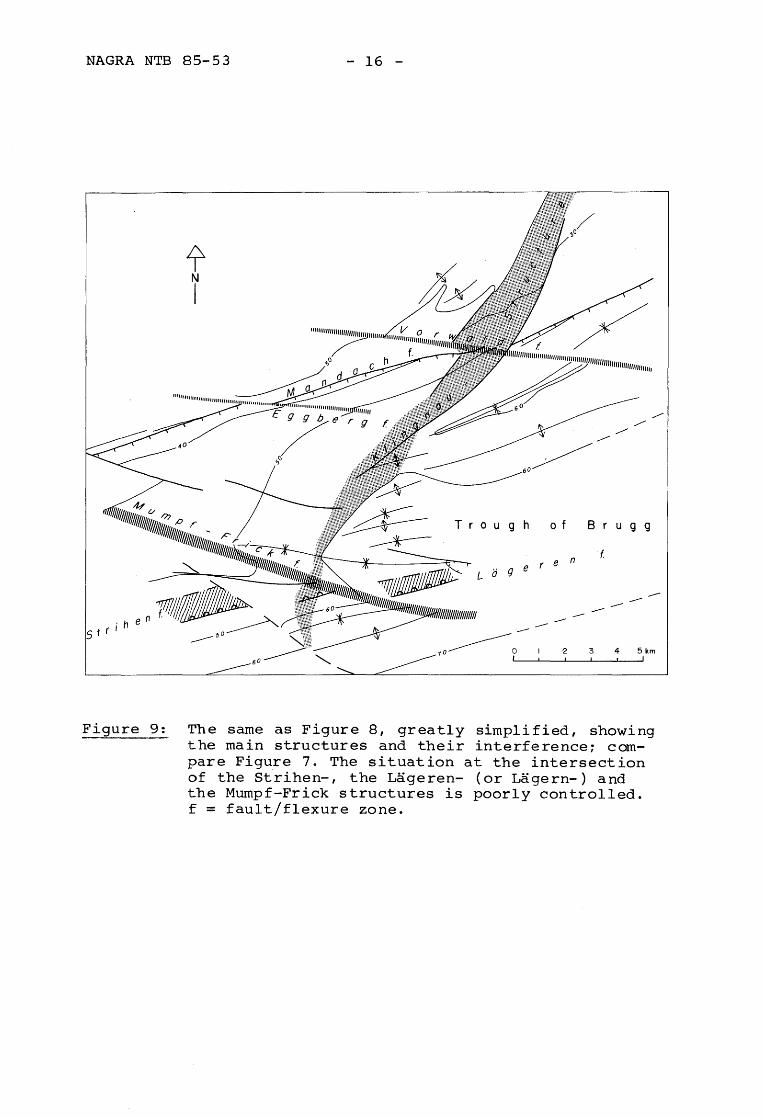
In Figure 6 an attempt was made to decipher the details of the sub-decollement structure of a larger area, as it would be important to understand the regional fault pattern. However, this is difficult because the good supra-decollement reflectors cannot be used for the identification of the small sub-decollement features, the evaporites usually causing disharmony of structure. There are possibly too many faults on Figure 6. Figure 7 is a smoothed-out version of Figure 6, retaining only the most important faults. Figure 8 is a reflection-time map of the sub-decollement structure based on Figure 6, somewhat simplified: only those faults were accepted that were either definite on the seismic records or else lined up easily and facilitated the contouring. An exception is the zone of interference of the Mandach-, the Vorwaldand the Klingnau-structures (see Figure 9). This area is evidently faulted in a complex way, although it is impossible at this time to define the pattern exactly. Figure 9 is a simplified version of Figure 8, in order to lay bare the main structural pattern, also compare Figure 7. The northern part is dominated by the ENE-trending Mandach flexure. The Mandach flexure interferes wi th a series of vAAl-trending structures, the most important of which is the Vorwald fault zone. It projects into the well-known Vorwald fault of the Black Forest. The Eggberg fault zone of the Black Forest is only weakly developed in the area of Figure 9. A more important vlffiv-trending zone is here named the Mumpf-Frick-zone which W of Figure 9 is characterized by a belt of NNE-striking small faults and narrow grabens in the Middle Triassic plateau NW of Frick. The Mandach flexure also interferes with the NE to ENE-trending Klingnau zone, which again seems to be a complexly faulted flexure, down to the ESE. The area of triple interference between the Mandach flexure, the Klingnau structure and the Vorwald fault zone is particularly complex, as already stated. E of the interference, the Mandach flexure (Line 55, Figure 4) is reduced to about 100 m. Svv of it, the faults of the Klingnau structure become much smaller; however, its persistent influence on the other structures is evident down to the southern limit of the map, compare Figure 8. It marks an axial flexure in the Brugg synclinorium and is also a boundary between the various minor structures occurring in that synclinorium. In the south it interferes with the Mumpf-Frick-trend on about Line 15, where the Aare
NAGRA NTB 85-53
NW
60
o
- 14 -
55
irOUgh ot --- 50
Frick
B rug 9 40
o I 2km
~:I
30/31
Figure 7: The sections of Figure 6, simplified, showing the main structures and their interference. f. means fault/flexure zone. For line-up and spacing of sections see Figure 6.
SE
15
NAGRA NTB 85-53 - 15 -
0 \ \ 0 \ !;; :e \
'" \ ~ \ \ \
0 \ ICl ...
""'\ \ \ \ .".
\ \ \ \
\ \
\ \ rt'l \
\ \ \
0...- ,\ C\J
'" I \ '" I \
\ I \
\ \
\ 0 \
099
Figure 8·- Reflect ion time contours on basal Triassic Buntsandstein. Contour interval 10 milliseconds (approx. 15 m). 40, 50 = 0.40, 0.50 seconds. Datum level at 500 m. Based on Figure 6, somewhat simplified. For location compare the seismic lines (thin lines) with Figure 3.
NAGRA NTB 85-53 - 16 -
f N
I
11111111111"
"'''''IIJ:~''''''''~~'''''IIJIlIlIlIlIlIlrm;;;;;;,
T r 0 u 9 h
(j 9 e r
------10 -------------0 ,
o f B r u 9 9
e n
----------------2 3 4 5km
I
Figure 9: The same as Figure 8, greatly simplified, showing the main structures and their interference; compare Figure 7. The situation at the intersection of the Strihen-, the Lageren- (or Lagern-) and the Mumpf-Frick structures is poorly controlled. f = fault/flexure zone.
NAGRA NTB 85-53 - 17 -
valley crosses the thrusts of the eastern Jura. On the east side of the Aare river the structure of the thrust belt is different from that on the west side: it seems that this sub-decollement trend also acted as a transverse zone in the supra-decollement structures. The southern part of the map is characterized by a series of flexures and warps that generally trend somewhat north of east and do not neatly line up on the various lines. This again seems to be due to oblique interference with the Klingnau and the Mumpf-Frick structures. The southern zone of warps marks the south-limb of the Brugg-synclinorium. At depth this coincides with the southern border zone of the main Paleozoic trough, just as the Mandach flexure, which is the northern limb of the Brugg synclinorium, also coincides with the northern border of the main Paleozoic trough. The Brugg synclinorium is thus the weakly reactivated Paleozoic trough, except for the fact that its axial plunge to the east is opposite to that of the Paleozoic trough (Nagra, 1985).
The Paleogene sub-decollement structures, though not defined in every desirable detail, are clearly different from the extensional fault blocks of the Rhinegraben or the Bavarian Molasse basin on the two sides of the area here examinede They rather resemble the Paleogene flexures of the Basel-Dijon transform zone (Laubscher, 1970). This suggests that these peculiar structures may be due to a transform zone between the Bavarian Molasse basin and the Rhine-Rhone graben systems, see Figure 1. Its coincidence with the Paleozoic Constance-Frick trough probably means that this inherited profound crustal inhomogeneity was a boundary for blocks of variable Paleogene extension.
3.3 Folds and thrusts of the easternmost Jura: geometry and relation to sub-decollement structure
The results of the seismic data analysis of the Mandach structure may now be compared with the somewhat less clear sub- and supra-decollement features to its south (Figure 10). The simplest of these structures is on Line 60 and probably corresponds to the Irchel fold (compare von Braun, 1953). It is the northernmost identifiable decollement fold east of the Mandach thrust. The underlying sub-decollement features are small but real, as the overlying velocity structure is but little disturbed. They reveal slight antithetic tilting
NAGRA NTB 85-53 - 18 -
of a small fault block, which is autochthonous with respect to the overlying decollement fault as tectonic transport stopped here. The main features are the following:
- the fold seems to have been nucleated at the leading edge of one ore more little thrusts emanating from the southern sub-decollement step.
- the fold as seen on the upper Jurassic and the overlying Tertiary projects no deeper than the Opalinus shales on top of the Lias reflector. The sub-Opalinus strata have been shortened in a different mode.
- the area of divergence between reflectors above and below the Opalinus shales is filled by apparently tightly spced small complementary thrusts, although the jumbled reflections here do not permit detailed analysis. Rotation of the fold limbs was supported by unterthrusting both north and south.
It is particularly the last point that is new. In several papers I have attempted to develop rules for extrapolation of surface features down to the decollement zone, using considerations of material balance (Laubscher 1956, 1977). Although I pointed out that there is an infinity of possible solutions compatible with this general constraint, I proposed to use the simplest methods of downward projection. In the case at hand, this would have lead to a simple box-fold rooted in the Middle Triassic, the core being supported by plastically deformed evaporites. It now appears that the mode of disharmony exhibited by the Irchel fold is the rule rather than the exception in the area. A number of other folds crossed by the seismic lines, although larger and more complex, show similar behaviour. Except for general conjectures the mechanical reason for this cannot be stated at present. However, I should like to point out that a similar disharmony was encountered in the lower plate of the Dottenberg thrust in the Hauenstein-Basistunnel, compare Laubscher (1983). A number of subordinate little kink bands and thrusts appear on good reflectors outside the main fold and are generally confined to narrow stratigraphic intervals. Although some of them are at the limit of seimsic resolution, I think the majority of them is real and points to a tendency for subordinate decollement in higher incompetent layers of the Mesozoic and possibly the Tertiary. This is particularly true for the MaIm;
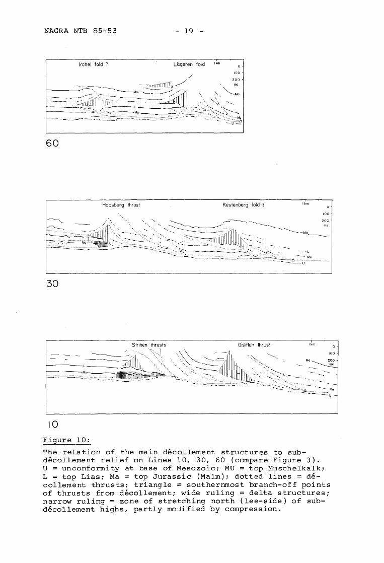
NAGRA NTB 85-53 - 19 -
Ikm Uigeren fold Irchel fold ? o
60
Habsburg thrust Kestenberg fold ? I km
30
Strihen thrusts Gislifluh thrust I km
10
Figure 10:
The relation of the main decollement structures to subdecollement relief on Lines 10, 30, 60 (compare Figure 3).
o
100
U = unconformity at base of Mesozoici MU = top Muschelkalki L = top Lias; Ma = top Jurassic (MaIm); dotted lines = decollement thrusts; triangle = southernmost branch-off points of thrusts from decollement; wide ruling = delta structures; narrow ruling = zone of stretching north (lee-side) of subdecollement highs, partly mo:lified by compression.
o
NAGRA NTB 85-53 - 20 -
comparable small features in the upper Jurassic are well known from surface exposures. Their existence points to the limitations of material balance considerations.
The decollement structures south of the main border thrust of the Jura imply shortenings on the order of a few kilometers and are obviously allochthonous. However, their relation to the small subdecollement structures is complex.
Figure 10 shows some of the most obvious types of Neogene supra-decollement structures and their relation to Paleogene sub-decollement tectonics. No attempt is made at a complete geological interpretation. The main irregularities are:
- Northvergent thrusts branching off from the basal decollement plane. Associated ramp folds tend to be the south limb of anticlines (compare Laubscher, 1983).
- Blind, northvergent thrusts giving rise to delta structures (e.g. Harding, 1985) with southvergent detachment thrusts originating at their tip, usually above the Lias reflector. Reflections from the core of the delta structures are jumbled and do not permit detailed analysis. The roof of the delta structures generally gives rise to the north-limb of folds. Frequently, small folds and subordinate north-vergent thrusts are added to the roof of the delta structure.
- Stretching phenomena on the lee-side of the obstacles to decollement mainly in the Triassic. They are believed to result from a pull-apart situation (downstep of decollement in the direction of movement).
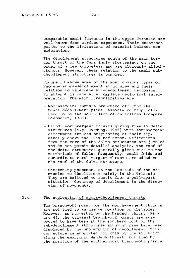
3.4 The nucleation of supra-decollement thrusts
The branch-off point for the north-vergent thrusts are not tied to an unique position on obstacles. However, as suggested by the Mandach thrust (Figure 4), the original branch-off points are suspected to have been at the southern foot of the sub-decollement structures although many have been displaced by the propagation of decollement. This conjecture is supported not only by the situation along the embryonic Mandach thrust, but also by the position of the southernmost branch-off points
NAGRA NTB 85-53 - 21 -
I <_._._._._.[ 0=.
A
~. .(- ] \ B
c
Figure 11: Three models for thrust (dot-dash) nucleation at sub-decollement structures.
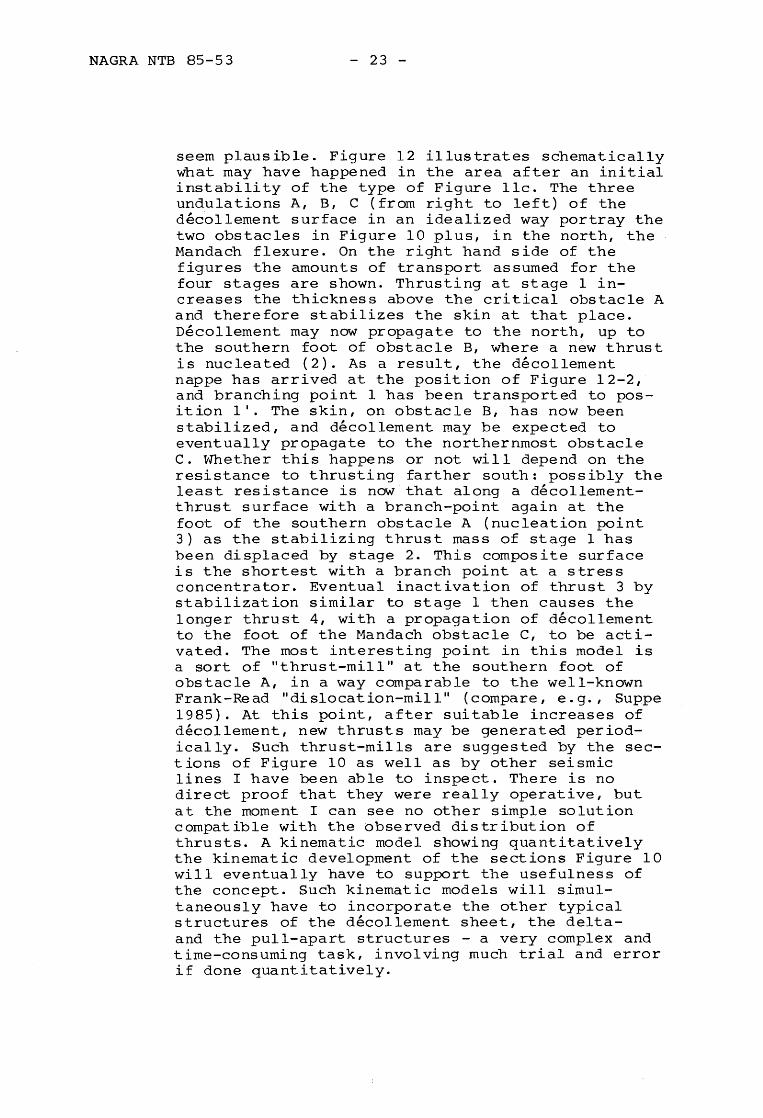
marked by triangles on the three sections of Figure 10. For those points no plausible sub-d~collement structure farther south is found as a cause for original nucleation, with subsequent transport to the north by continued d~collement. It thus looks as if the points marked by a triangle had been about the last nucleation points before Jura decollement stopped. Nucleation points on the leeside of obstacles are consequently thought to have been transportes from an original position on that side of the obstacle opposed to the movement (compare Figure 12).
Figures 11 and 12 schematically illustrate this sequence of events. In Figure lla the model for nucleation of thrusts at the upside of a normal fault is illustrated as postulated by Laubscher (e.g. 1977). This simple model was proposed for the Rheintal-Jura, where norm~l faults of the Rhinegraben-system are known to enter the Jura. However, these situations are nowhere exposed, and it is possible that in many parts of the RheintalJura similar obstacles tod~collement exist as those shown in Figure 10; this may be expected particularly for parts of the Rhine-Bresse transform system. Figure lIb portrays the situation of
NAGRA NTB 85-53 - 22 -
-.-._-- -_._--_.-c B A
2
3
c A 3"- - -'- -'- -'-'
4
Figure 12: A qualitative model of successive thrust nucleation in the course of decollement in the eastern Jura. Dot-dashed lines are active thrusts, dashed lines are inactivated thrusts. Numbers and full circles are successive nucleation points, numbers with primes are displaced, numbers with double primes are twice displaced nucleation points. North is left.
a fault step facing decollement such as that in Figure 4, and Figure llc that of an idealized broken sub-decollement fold. At the southern foot of the obstacle stress concentrations will develop because a simple translation without internal deformation is not possible. Stability in this area may be further decreased by erosional thinning of section on top of the fold. Altogether the nucleation of the thrust in the position shown would
NAGRA NTB 85-53 - 23 -
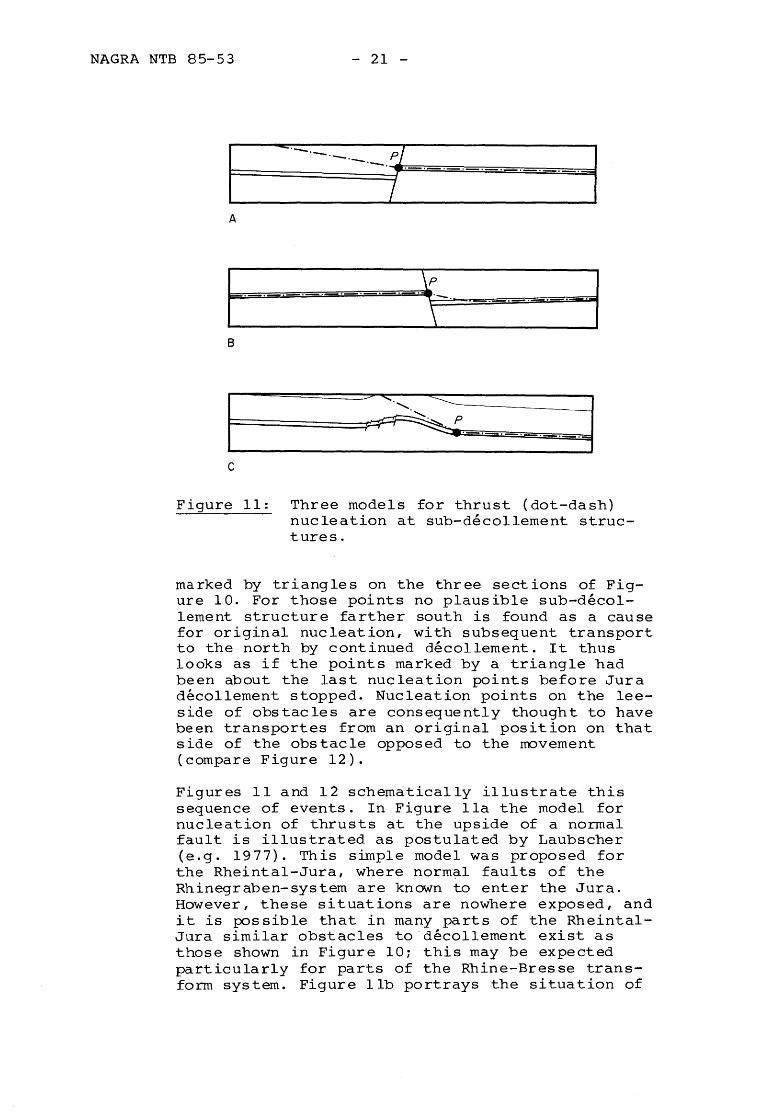
seem plausible. Figure 12 illustrates schematically what may have happened in the area after an initial instability of the type of Figure llc. The three undulations A, B, C (from right to left) of the decollement surface in an idealized way portray the two obstacles in Figure 10 plus, in the north, the Mandach flexure. On the right hand side of the figures the amounts of transport assumed for the four stages are shown. Thrusting at stage 1 increases the thickness above the critical obstacle A and therefore stabilizes the skin at that place. Decollement may now propagate to the north, up to the southern foot of obstacle B, where a new thrust is nucleated (2). As a result, the decollement nappe has arrived at the position of Figure 12-2, and branching point 1 has been transported to position I'. The skin, on obstacle B, has now been stabilized, and decollement may be expected to eventually propagate to the northernmost obstacle c. Whether this happens or not will depend on the resistance to thrusting farther south: possibly the least resistance is now that along a decollementthrust surface with a branch-point again at the foot of the southern obstacle A (nucleation point 3) as the stabilizing thrust mass of stage 1 has been displaced by stage 2. This composite surface is the shortest with a branch point at a stress concentrator. Eventual inactivation of thrust 3 by stabilization similar to stage 1 then causes the longer thrust 4, with a propagation of decollement to the foot of the Mandach obstacle C, to be activated. The most interesting point in this model is a sort of "thrust-mill" at the southern foot of obstacle A, in a way comparable to the well-known Frank-Read "dislocation-mill" (compare, e.g., Suppe 1985). At this point, after suitable increases of decollement, new thrusts may be generated periodically. Such thrust-mills are suggested by the sections of Figure 10 as well as by other seismic lines I have been able to inspect. There is no direct proof that they were really operative, but at the moment I can see no other simple solution compatible with the observed distribution of thrusts. A kinematic model showing quantitatively the kinematic development of the sections Figure 10 will eventually have to support the usefulness of the concept. Such kinematic models will simultaneously have to incorporate the other typical structures of the decollement sheet, the delta-and the pull-apart structures - a very complex and time-consuming task, involving much trial and error if done quantitatively.
NAGRA NTB 85-53 - 24 -
4 INDICATIONS OF PALEOGENE IRREGULARITIES IN THE DECOLLEMENT SURFACE WEST OF FIGURE 3
Figure 10 shows the apparent relation between subdecollement irregularities and thin-skin structures. It demonstrates, together with the model Figure 12, that the relation between the two is complex. In spite of this, irregular structural trends in the interior of the Jura, which by their departure from a regular overall pattern suggest the presence of some inherited imhomogeneity, may be used to propose an extension of the Paleogene structural system. Moreover, if the influence of late Paleozoic structures on the Paleogene pattern is considered, by analogy with the eastern Jura, some speculations as to the presence of late Paleozoic structures under the Jura may briefly be sketched.
The most important Paleogene sub-decollement struc~ ture may exist below the southern foot of the western Jura. It may be the thrust mill for the Faisceau He1vetique, the most intensely deformed innermost belt of the Jura system (Figure 2). The rationale for postulating the existence of this structure or belt of structures is as follows.
The St.-Etienne trough in its northeastern continuation defines the southwestern end of the Faisceau Helvetique (Figure 2). This late Paleozoic trough has not only had a great influence on the development of Mesozoic facies and thicknesses (Debrand-Passard, 1984), it also coincides with the southern end of the Bresse- and Limagne grabens (Figure 1). It thus had a regional influence on Paleogene developments. The extrapolation of its axis to the northeast approximately parallels the southern border of the Jura and trends towards the Constance-Frick trough. For the area in between, Aubert (1958) has called attention to a pronounced angular unconformity between the Mesozoic and the Oligocene conglomerates in the Vallee de Joux.
The Faisceau Helvetique is characterized by repeated largescale thrusting (compare Laubscher, 1965; Bitterli, 1972). Important thrusting in the southern part of this belt is apparently the youngest (Laubscher, 1965). A plausible explanation compatible with the information would be that of a thrust mill similar to that of the model Figure 12.
NAGRA NTB 85-53 - 25 -
Laubscher (1972), for lack of detailed information; had proposed to consider the general increase ih thickness of the Tertiary as the condition determining the southern boundary of the folded Jura. I should like now to refine that notion as sketched above.
These arguments are hardly sufficient to raise the conjecture above the level of a plausible scenario, but I think they are interesting enough to deserve being kept in mind as further information becomes available.
In the western Jura, the next important fold belt to the north is the Faisceau Salinois which merges with the border thrust on the Bresse graben or Faisceau Ledonien at Salins. The thrusts and folds composing the Faisceau Salinois are arranged in a dextral en-echelon pattern, which characterizes it as a transpressive belt. As such transpressive belts are oblique to the principal stresses and the vector of translation, they require an inherited zone of weakness, otherwise thrusts and elongate cylindrical folds should form.
In the central part of the Rheintal-Jura, several authors have repeatedly called attention to the influence of inherited Rhinegraben structures (e.g. Liniger, 1926; Laubscher, 1980).
East of the eastern border of the Rhinegraben proper, there are numerous suggestive deviations fram average regional trends. One of the most prominent of these is the change in trend of the frontal Jura structures near Eptingen, in the dissertation area of Hans Cloos (1910; see also "Geologische Karte der Schweiz II 1 : 500' 000). "Jest of Eptingen the trend is V1NW and shows structures reminiscent of a dextrally transpressive boundary. East of Eptingen the trend is ENE with unmistakable sinistrally transpressive arrangements. The VlNW trend passes into the Landskron flexure which is known to be associated with the Paleogene Rhinegraben. It may be speculated that the ENE trend belongs to the southern margin of the ConstanceFrick trough, extended to the west (compare Laubscher & Pfirter, 1984). Both trends continue into the Jura. As these speculations are of great practical importance, they will no doubt be checked and supplemented by geophysical and eventually drilling information.
NAGRA NTB 85-53 - 26 -
5 CONCLUSIONS
New seismic lines across the eastern folded Jura and its foreland reveal that three events are responsible for the geometry of Jura tectonics in that area. A deep, faulted, late Paleozoic trough trending ENE (the Constance-Frick trough) was slightly reactivated in the Paleogene, apparently as a transform zone between parts of the extensional fields of the Molasse basin of Bavaria and the Rhine-Rhone-graben system. The resulting Paleogene tectonics are characterized by small faulted flexures and folds. During Jura decollement in the Noegene these inherited sub-decollement structures remained passive but localized initiation of thrusting.
Nucleation points on the decollement plane apparently were mostly the changes in slope at the southern foot of the sub-decollement flexures and folds. Particularly the southernmost of them was probably re-used repeatedly after intervals of northward propagation of decollement. There is no indication of a participation of basement during Neogene compression: all the available evidence supports the impression that the sub-decollement thrusting and folding are Paleogene; in addition, their small size is incompatible with the intense supra-decollement thrusting and folding. Projection of these results into the western Jura suggests that the southern foot of the Jura and some of its more important thrust belts may have been similarly localized: the late Paleozoic trough of St. Etienne points toward the southwestern end of the Jura, where Tertiary unconformities are reminiscent of the small sub-decollement wrinkles in the eastern Jura that were produced by reactivation of late Paleozoic fault zones.
Acknowledgments
I thank NAGRA for permission to publish this article, and particularly Peter Diebold for invaluable help and stimulating discussions. Several of my students have assisted in preparing the illustrations.
NAGRA NTB 85-53 - 27 -
6 BIBLIOGRAPHY
ANGELIER, J. & LE PICHON, Y. (1980): La sUbduction hellenique et l'expansion egeenee: reconstitution cinematique et interpretation dynamique. C.R. somm. Soc. geol. France 5, 158 - 161.
ARTHAUD, F. & MATTE, P. (1977): Late Paleozoic strike-slip faulting in Southern Europe and Northern Africa; results of a right-lateral shear zone between the Appalachians and the Urals. Bull. Geol. Soc. Amer. 88, 1305 - 1320.
AUBERT, D. (1958): Sur l'existence d'une ride de plissement oligocene dans Ie Jura vaudois. Bull. Soc. neuchat. Sci. nat. 81, 47 - 54.
BETZ, D. & HENDT, A. (1983): Neuere Ergebnisse der Aufschluss- und Gewinnungstatigkeit auf Erdal und Erdgas in Sliddeutschland. Bull. Ver. schweiz. Petroleum-Geol. u. -lng. 49/117, 9 - 36.
BITTERLI, P. (1972): Erdolgeologische Forschungen im Jura. Bull. Ver. schweiz. Petroleum-Geol. u. -Ing. 39/95, 13 - 28.
BRAENDLIN, E. (1911): Zur Geologie des nardlichen Aargauer Tafeljura zwischen Aare- und Fricktal. Verh. natf. Ges. Basel 22/1, 57 - 148.
BUXTORF, A. (1907): Zur Tektonik des Kettenjura. Ber. Versamml. oberrh. geol. Ver., 30. /40. Versamml., 1906/7, 29 - 38.
BUXTORF, A. & NIGGLI, P. (1934): Laufenburg-Etzgen (Schwarzwaldkristallin) und Aargauer Tafeljura. Geol. Flihrer der Schweiz 8, Centralschweiz, Exkursion Nr. 34 B, 534 - 539. Schweiz. Geol. Ges., Basel.
CLOOS, H. (1910): Tafel- und Kettenland im Basler Jura und ihre tektonischen Beziehungen nebst Beitragen zur Kenntnis des Tertiars. N. Jb. Mineral. Geol. Palaont. Beilbd. 30, 97 - 232.
CLOOS, H. (1939): Hebung - Spaltung - Vulkanismus. Geol. Rdsch. 30, 401 - 527.
NAGRA NTB 85-53 - 28 -
DEBRAND-PASSARD, S. (1984): Synthese geologique du sud-est de la France. Mem. Bur. Rech. geol. min. 125 + 126.
GEOLOGISCHE Karte der zentralen Nordschweiz, 1984, 1 : 100'000. Geol. Spezialkarte Nr. 121. Nagra & Schweiz. Geol. Komm., Bern.
GEOLOGISCHE Karte der Schweiz, 1980, 1 : 500'000. Schweiz. Geol. Komm., Bern.
HARDING, T.P. (1985): Seismic characteristics and identification of negative flower structures, positive flower structures, and positive structural inversion. Bull. Amer. Assoc. Petroleum Geol. 69/4, 582 - 600.
HAUBER, L. (1960): Geologie des Tafel- und Faltenjura zwischen Reigoldswil und Eptingen. Beitr. geol. Karte Schweiz. N.F. 112.
LAUBSCHER, H. (1956): Deformations along faults in E Venez uela. Geophysics 21/2, 368 - 387.
LAUBSCHER, H.P. (1965): Ein kinematisches Modell der Jurafaltung. Eclogae geol. Helv. 58/1, 232 - 318.
LAUBSCHER, H.P. (1970): Grundsatzliches zur Tektonik des Rheingrabens. In: Graben Problems. Int. Upper Mantle Proj. Sci. Rep. 27. Schweizerbart, Stuttgart.
LAUBSCHER, H.P. (1972): Some overall aspects of Jura dynamics. Amer. J. Sci. 272, 293 - 304.
LAUBSCHER, H.P. (1973a): Jura mountains. In: Gravity and Tectonics. K.A. DeJong & R. Scholten, Eds., John Wiley, Chichester.
LAUBSCHER, H.P. (1973b): Faltenjura und Rheingraben: Zwei Grossstrukturen stossen zusammen. Jber. Mitt. oberrh. geo1. Ver. 55, 145 - 158.
LAUBSCHER, H.P. (1977): Fold development in the Jura. Tectonophysics 37, 337 - 362.
LAUBSCHER, H.P. (1978): Foreland folding. Tectonophysics 47, 325 - 337.
NAGRA NTB 85-53 - 29 -
LAUBSCHER, H.P. (1980): Die Entwicklung des Faltenjuras - Daten und Vorstellungen. N. Jb. Geol. Palaont. Abh. 160/3, 289 - 320.
LAUBSCHER, H.P. (1981): The 3D propagation of decollement in the Jura. In: Thrust and Nappe Tectonics. Geol. Soc. London, 311 - 318.
LAUBSCHER, H.P. (1983): Ueberschiebungen im Jura. Jber. Mitt. oberrh. geol. Ver. 65, 181 - 189.
LAUBSCHER, H. & PfIRTER, U. (1984): Bericht Uber die Exkursion der Schweizerischen Geologischen Gesellschaft in den ostlichen Faltenjura, vom 15. bis 17. Oktober 1983. Eclogae geol. Helv. 77/1, 205 - 219.
LAUBSCHER, H.P. (1985): The late Alpine (Periadriatic) intrusions and the Insubric line. Mem. Soc. geol. ital., in print.
LEFAVRAIS-RAYMOND, A. (1962): Contribution a l'etude geologique de la Bresse d'apres les sondages profonds. Mem. Bur. Rech. geol. min. 16, p. 170.
LEMCKE, K. (1981): Das heutige geologische Bild des deutschen Alpenvorlandes nach drei Jahrzehnten Oel- und Gasexploration. Eclogae geol. Helv. 74/1, 1 - 18.
LINIGER, H. (1926): Ueber Gi tterfal tung im Bernerjura. Eclogae geol. Helv. 19, 625 - 629.
LUTZ, M. (1964): Stratigraphie und tektonische Untersuchungen am slidwestlichen Schwarzwaldrand zwischen Hiesental und Hochrhein. Oberrh. geol. Abh. 13/1-2, 75 - 122.
NAGRA Projektbericht NGB 85-04. Projekt Gewahr 1985. Endlager fUr hochaktive Abfalle: Das System der Sicherheitsbarrieren. Nationale Genossenschaft fUr die Lagerung radioaktiver Abfalle, Baden.
STELLRECHT, R. (1963): Zur Stratigraphie und Tektonik der Weitenauer Vorberge am Slidostende des Oberrheingrabens. Oberrh. geol. Abh. 12, 119 - 127.
NAGRA NTB 85-53 - 30 -
SUPPE, J. (1985): Principles of Structural Geology. Prentice Hall Inc. Englewood Cliffs, New J e r s ey 0 7 63 2 .
VON BRAUN, E. (1953): Geologische und sedimentpetrographische Untersuchungen im Hochrheingebiet zwischen Zurzach und Eglisau. Eclogae geol. Helv. 46, 143 - 170.
~vITHJACK, M.O. & SCHEINER, C. (1982) : Fault pa tterns associated with domes - An experimental and analytical study. Bull. Amer. Assoc. Petroleum Geol. 66/3, 302 - 316.
ZIEGLER, P.A. (1982): Geological Atlas of Western and Central Europe. Shell Internationale Petroleum Maatschappij B.V., The Hague.