Embed Size (px)
Citation preview
R u m ä n i s c h e T i e f e b e ne
Do
bru
t sc
ha
D i n a r i s c h e s G e b i r g e
Z e n t r a l a l p e n N ö r d l i c h e K a l k a l p e n
Nö r d l i c h e s A l p e n v o r l a n d
Bes sa r a b i e n
B a l k a n g e b i r g e
S ü d l i c h e K a l k a l p e n Ung
aris
che T
iefe
bene
LEGENDE
Donaueinzugsgebiet
Donau
Zuflüsse (Flusseinzugsgebiet > 4,000 km 2 )
Seen (Wasseroberfläche > 100 km 2 )
Schwarzes Meer Küsteneinzugsgebiet
Lagunen (Wasseroberfläche > 100 km 2 )
Kanäle
Höhe über dem Meeresspiegel (m)
Staatsgrenzen
Städte: > 1,000,000 EinwohnerInnen
250,000 - 1,000,000 EinwohnerInnen
100,000 - 250,000 EinwohnerInnen
Kilometer
Maßstab:
This product includes geographical data licensed from European National Mapping Agencies. EuroGlobalMap v1.0 (EuroGeographics) was used as the basic topographic layer for DE, AT, CZ, IT, SI and HR. The data for the other countries is based on VMAP Level 0 data from NIMA. The outer border of the DRBD is based on national information from DE, AT, CH, CZ, SK, SI, HR, BA, CS, BG, RO, UA and MD. For PL, AL, MK and IT the data of the European Commission (Joint Research Centre) was used.
Prepared by FLUVIUS, Vienna, June 2005; The production of this map was financially supported by
The digital elevation model (DEM) is based on the global GETOPO30 data with a horizontal grid spacing of approximately one kilo meter.
Ein Produkt der IKSD, Wien
DEUTSCHLAND
SCHWEIZ
ITALIEN
TSCHECHISCHE REPUBLIK
ÖSTERREICH
SLOWENIEN
KROATIEN
UNGARN
BOSNIEN UND HERZEGOWINA
SERBIEN
RUMÄNIEN
REPUBLIK MOLDAU
UKRAINE
POLEN
SLOWAKEI
BULGARIEN
SCHWARZES MEER
MAZEDONIEN ALBANIEN
MONTENEGRO
Ta t r a
O
s t k ar p
at e
n
S ü d k a r p a t e n
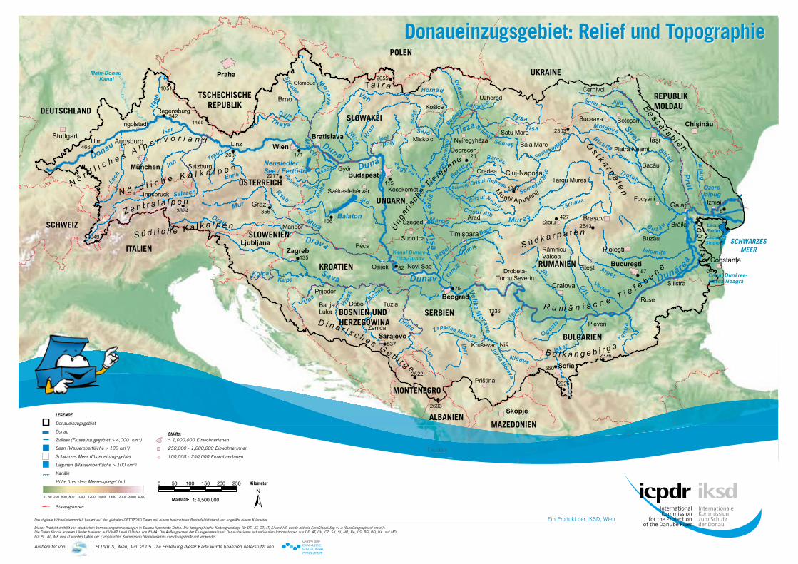
Donaueinzugsgebiet: Relief und Topographie
Das digitale Höhenlinienmodell basiert auf den globalen GETOPO30 Daten mit einem horizontalen Rasterfeldabstand von ungefähr einem Kilometer.
Dieses Produkt enthält von staatlichen Vermessungseinrichtungen in Europa lizenzierte Daten. Die topographische Kartengrundlage für DE, AT, CZ, IT, Sl und HR wurde mittels EuroGlobalMap v1.o (EuroGeographics) erstellt. Die Daten für die anderen Länder basieren auf VMAP Level 0 Daten von NIMA. Die Außengrenzen der Flussgebietseinheit Donau basieren auf nationalen Informationen aus DE, AT, CH, CZ, SK, Sl, HR, BA, CS, BG, RO, UA und MD. Für PL, AL, MK und IT wurden Daten der Europäischen Kommission (Gemeinsames Forschungszentrum) verwendet.
Aufbereitet von FLUVIUS, Wien, Juni 2005. Die Erstellung dieser Karte wurde finanziell unterstützt von
This product includes geographical data licensed from European National Mapping Agencies. EuroGlobalMap v1.0 (EuroGeographics) was used as the basic topographic layer for DE, AT, CZ, IT, SI and HR. The data for the other countries is based on VMAP Level 0 data from NIMA. The outer border of the DRBD is based on national information from DE, AT, CH, CZ, SK, SI, HR, BA, CS, BG, RO, UA and MD. For PL, AL, MK and IT the data of the European Commission (Joint Research Centre) was used.
Prepared by FLUVIUS, Vienna, June 2005; The production of this map was financially supported by
The digital elevation model (DEM) is based on the global GETOPO30 data with a horizontal grid spacing of approximately one kilometer.
ein Produkt von ICPDR, WienEin Produkt der IKSD, Wien