Embed Size (px)
Citation preview
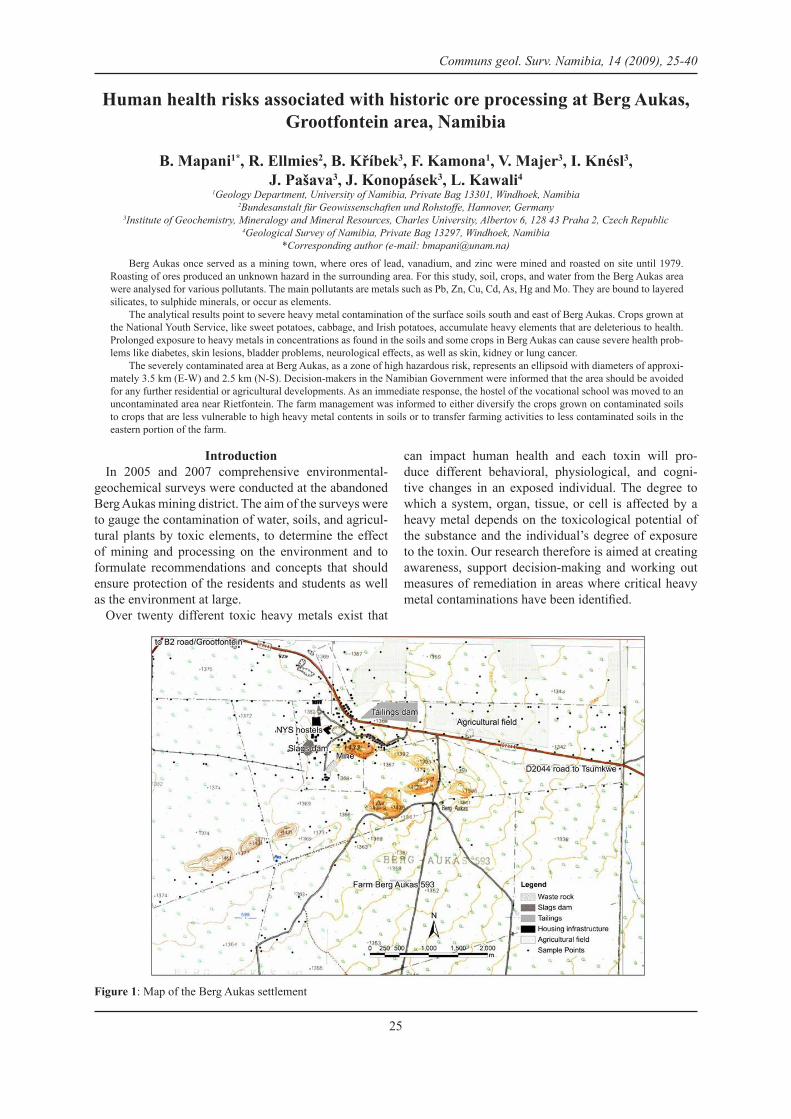
Human health risks associated with historic ore processing at Berg Aukas, Grootfontein area, Namibia
B. Mapani1*, R. Ellmies2, B. Kříbek3, F. Kamona1, V. Majer3, I. Knésl3, J. Pašava3, J. Konopásek3, L. Kawali4
1Geology Department, University of Namibia, Private Bag 13301, Windhoek, Namibia2Bundesanstalt für Geowissenschaften und Rohstoffe, Hannover, Germany
3Institute of Geochemistry, Mineralogy and Mineral Resources, Charles University, Albertov 6, 128 43 Praha 2, Czech Republic 4Geological Survey of Namibia, Private Bag 13297, Windhoek, Namibia
*Corresponding author (e-mail: [email protected])
Berg Aukas once served as a mining town, where ores of lead, vanadium, and zinc were mined and roasted on site until 1979. Roasting of ores produced an unknown hazard in the surrounding area. For this study, soil, crops, and water from the Berg Aukas area were analysed for various pollutants. The main pollutants are metals such as Pb, Zn, Cu, Cd, As, Hg and Mo. They are bound to layered silicates, to sulphide minerals, or occur as elements.
The analytical results point to severe heavy metal contamination of the surface soils south and east of Berg Aukas. Crops grown at the National Youth Service, like sweet potatoes, cabbage, and Irish potatoes, accumulate heavy elements that are deleterious to health. Prolonged exposure to heavy metals in concentrations as found in the soils and some crops in Berg Aukas can cause severe health prob-lems like diabetes, skin lesions, bladder problems, neurological effects, as well as skin, kidney or lung cancer.
The severely contaminated area at Berg Aukas, as a zone of high hazardous risk, represents an ellipsoid with diameters of approxi-mately 3.5 km (E-W) and 2.5 km (N-S). Decision-makers in the Namibian Government were informed that the area should be avoided for any further residential or agricultural developments. As an immediate response, the hostel of the vocational school was moved to an uncontaminated area near Rietfontein. The farm management was informed to either diversify the crops grown on contaminated soils to crops that are less vulnerable to high heavy metal contents in soils or to transfer farming activities to less contaminated soils in the eastern portion of the farm.
Communs geol. Surv. Namibia, 14 (2009), 25-40
IntroductionIn 2005 and 2007 comprehensive environmental-
geochemical surveys were conducted at the abandoned Berg Aukas mining district. The aim of the surveys were to gauge the contamination of water, soils, and agricul-tural plants by toxic elements, to determine the effect of mining and processing on the environment and to formulate recommendations and concepts that should ensure protection of the residents and students as well as the environment at large.
Over twenty different toxic heavy metals exist that
can impact human health and each toxin will pro-duce different behavioral, physiological, and cogni-tive changes in an exposed individual. The degree to which a system, organ, tissue, or cell is affected by a heavy metal depends on the toxicological potential of the substance and the individual’s degree of exposure to the toxin. Our research therefore is aimed at creating awareness, support decision-making and working out measures of remediation in areas where critical heavy metal contaminations have been identified.
Figure 1: Map of the Berg Aukas settlement
25
Geology of Berg Aukas area
Berg Aukas is located 15km east of Grootfontein on the farm Berg Aukas 593, in the Otavi Mountain Land, Namibia (Figure 1). The area is located on good loamy soils that are underlain by carbonates. Currently the Na-tional Youth Service (NYS) uses most of the residential houses, workshops and hostels of the former mine as an agricultural vocational school and the farmland to the east of the tailings dump as an experimental crop farm.
The Berg Aukas mine is situated on the northern limb of the Berg Aukas Syncline. The syncline structure con-sists of dolostones, limestones and shales of the Berg Aukas Formation (at the base of Abenab Subgroup/Otavi Group). The Berg Aukas Formation is part of the Neoproterozoic sedimentation on the Otavi Platform. The sedimentary rocks were folded during the Pan-Af-rican Event.
Two types of lead-zinc-vanadium mineralization oc-cur at the Berg Aukas mine (Misiewicz, 1988):
(i) The Northern Ore Horizon consists of a series of lenses with oxidized ore of sulphide replacement bod-ies. The ore occurs along the contact between two tex-turally distinct varieties of grey dolomite. The zone of mineralization strikes roughly east-west and dips about 50° to the south. In the topmost lens, the sulphides are confined to massive, fine-grained replacement bodies in which sphalerite, galena and subordinate pyrite are the only visible primary sulphides. Common second-ary minerals are descloizite, willemite, cerussite, smith-sonite and goethite.
(ii) The complex Central Ore Body, Intermediate and Hanging Wall Ore Body are located in recrystallised dolomite, in which they follow solution cavities that are controlled by steeply dipping north-south striking frac-tures. Ore bodies are arranged in an en echelon pattern, and dip almost vertically. In addition, the bodies are extremely irregular in outline and frequently contain blocks of barren dolomite. Galena and sphalerite, partly oxidized, are disseminated in layers of clay, mud and sand of varying dolomite content. The contacts between the ore bodies and country rocks are sporadically lined
with crystalline willemite.
Mining and mining remnants
The lead-zinc-vanadium deposit of Berg Aukas was discovered in 1913, when the apex of the Central Ore Body on top of a hill was located. Mining started in 1920 and was terminated at the groundwater level in 1928. In 1950 the mine was re-opened and vanadinite and sulphide concentrate was produced and roasted on the spot. The ore reserves at the time of mine closure in 1978 were estimated as 1.65 Mt grading 0.6% V2O5, 5% Pb and 17% Zn (Misiewicz, 1988).
Remnants of two waste rock heaps are located di-rectly on the area of the former mining and metallurgi-cal complex (Figure 1). The waste dumps are not stable and in some places, slumping of large blocks and water erosion furrows can be observed. Access to some gal-leries of the old mine is not secured. The total amount of material deposited in waste rock heaps is estimated at 91,680 m3.
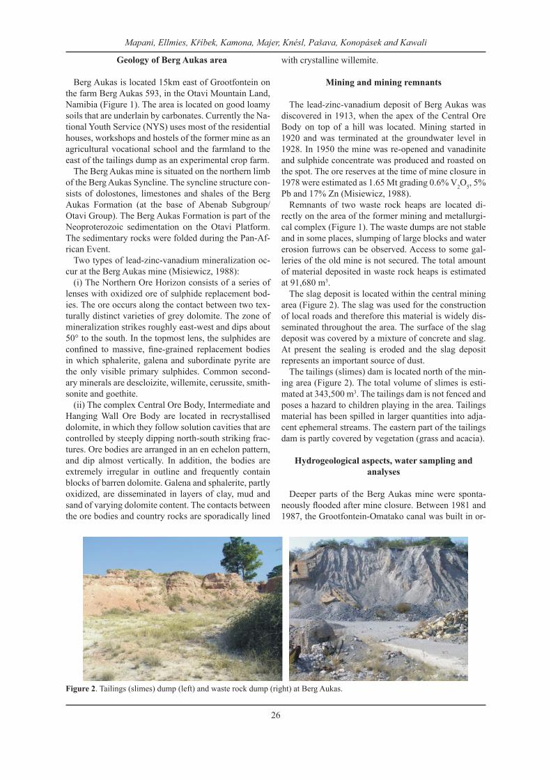
The slag deposit is located within the central mining area (Figure 2). The slag was used for the construction of local roads and therefore this material is widely dis-seminated throughout the area. The surface of the slag deposit was covered by a mixture of concrete and slag. At present the sealing is eroded and the slag deposit represents an important source of dust.
The tailings (slimes) dam is located north of the min-ing area (Figure 2). The total volume of slimes is esti-mated at 343,500 m3. The tailings dam is not fenced and poses a hazard to children playing in the area. Tailings material has been spilled in larger quantities into adja-cent ephemeral streams. The eastern part of the tailings dam is partly covered by vegetation (grass and acacia).
Hydrogeological aspects, water sampling and analyses
Deeper parts of the Berg Aukas mine were sponta-neously flooded after mine closure. Between 1981 and 1987, the Grootfontein-Omatako canal was built in or-
Figure 2. Tailings (slimes) dump (left) and waste rock dump (right) at Berg Aukas.
Mapani, Ellmies, Kříbek, Kamona, Majer, Knésl, Pašava, Konopásek and Kawali
26
der to supply water from Berg Aukas, Kombat and oth-er mines in the Otavi Mountain Land to Windhoek. The mines in the Otavi Mountain Land can supply a total of 15 Mm3 water per year (Ploethner et al., 1998). The groundwater from the underground mine of Berg Aukas is currently used for the water supply of the town itself and for irrigation of surrounding farming projects.
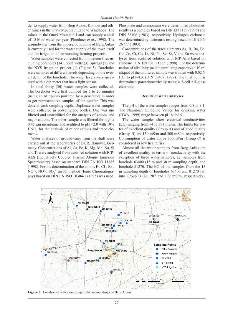
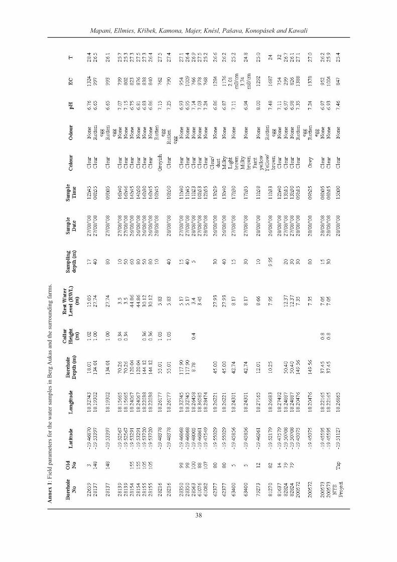
Water samples were collected from nineteen sites in-cluding boreholes (14), open wells (3), springs (1) and the NYS irrigation project (1) (Figure 3). Boreholes were sampled at different levels depending on the over-all depth of the borehole. The water levels were meas-ured with a dip meter that has a light sensor.
In total thirty (30) water samples were collected. The boreholes were first pumped for 5 to 20 minutes (using an MP pump powered by a generator) in order to get representative samples of the aquifer. This was done at each sampling depth. Duplicate water samples were collected in polyethylene bottles. One was un-filtered and unacidified for the analysis of anions and major cations. The other sample was filtered through a 0.45 µm membrane and acidified to pH <2.0 with 10% HNO3 for the analysis of minor cations and trace ele-ments.
Water analyses of groundwater from the shaft were carried out at the laboratories of BGR, Hanover, Ger-many. Concentrations of Al, Ca, Fe, K, Mg, Mn, Na, Si and Ti were analysed from acidified solution with ICP-AES (Inductively Coupled Plasma Atomic Emission Spectrometry) based on standard DIN EN ISO 11885 (1998). For the determination of the anions F-, Cl-, Br-, NO3-, NO2-, SO4
2- an IC method (Ionic Chromatogra-phy) based on DIN EN ISO 10304-1 (1995) was used.
Phosphate and ammonium were determined photomet-rically as a complex based on DIN EN 1189 (1996) and DIN 38406 (1983), respectively. Hydrogen carbonate was determined by titrimetric testing based on DIN EN 26777 (1993).
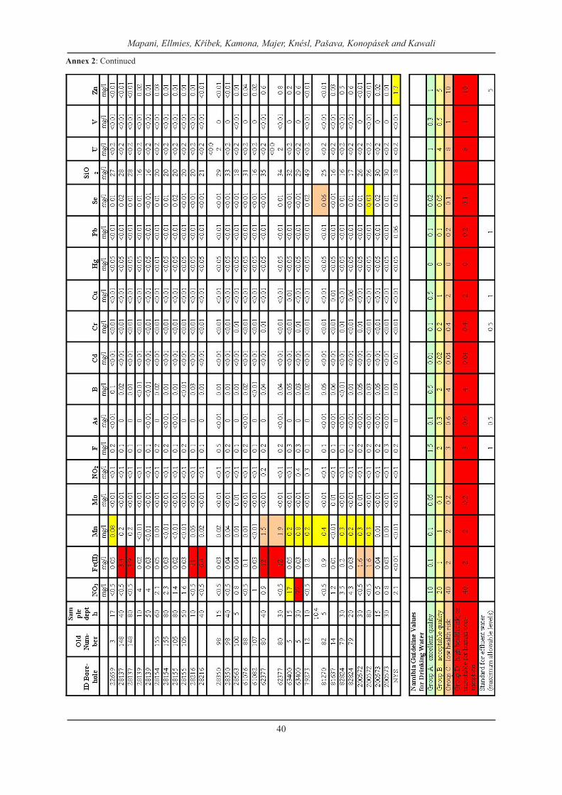
Concentrations of the trace elements As, B, Ba, Be, Cd, Co, Cr, Cu, Li, Ni, Pb, Sc, Sr, V and Zn were ana-lysed from acidified solution with ICP-AES based on standard DIN EN ISO 11885 (1998). For the determi-nation of alkalinity (acid neutralizing capacity) a 10 ml aliquot of the unfiltered sample was titrated with 0.02 N HCl to pH=4.3. (DIN 38409, 1979). The final point is determined potentiometrically using a 2-cell pH-glass electrode.
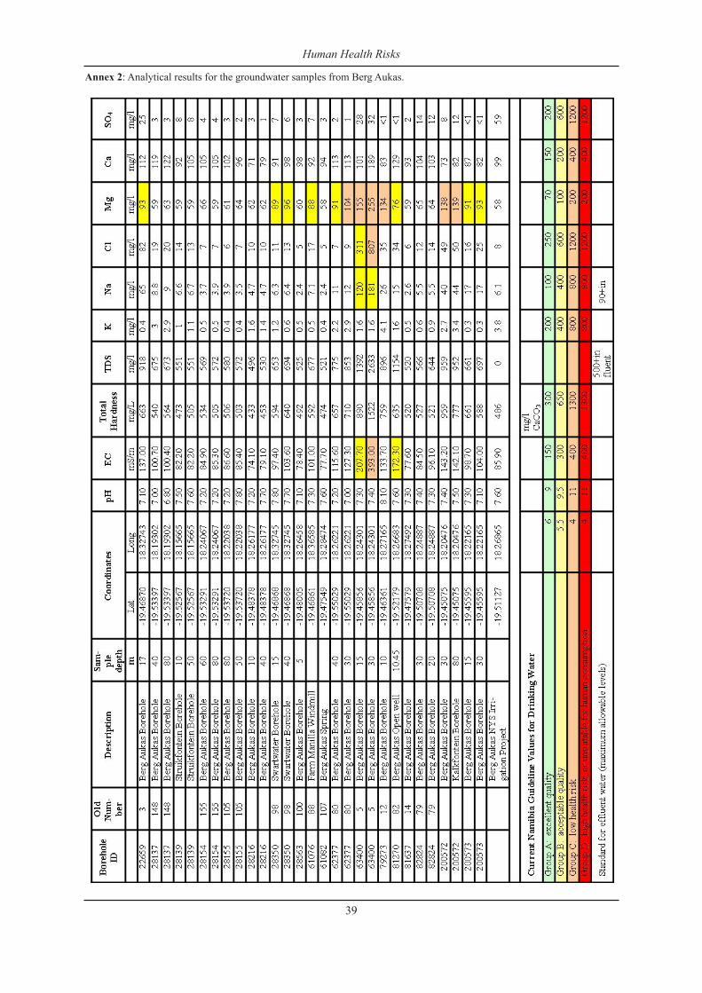
Results of water analyses
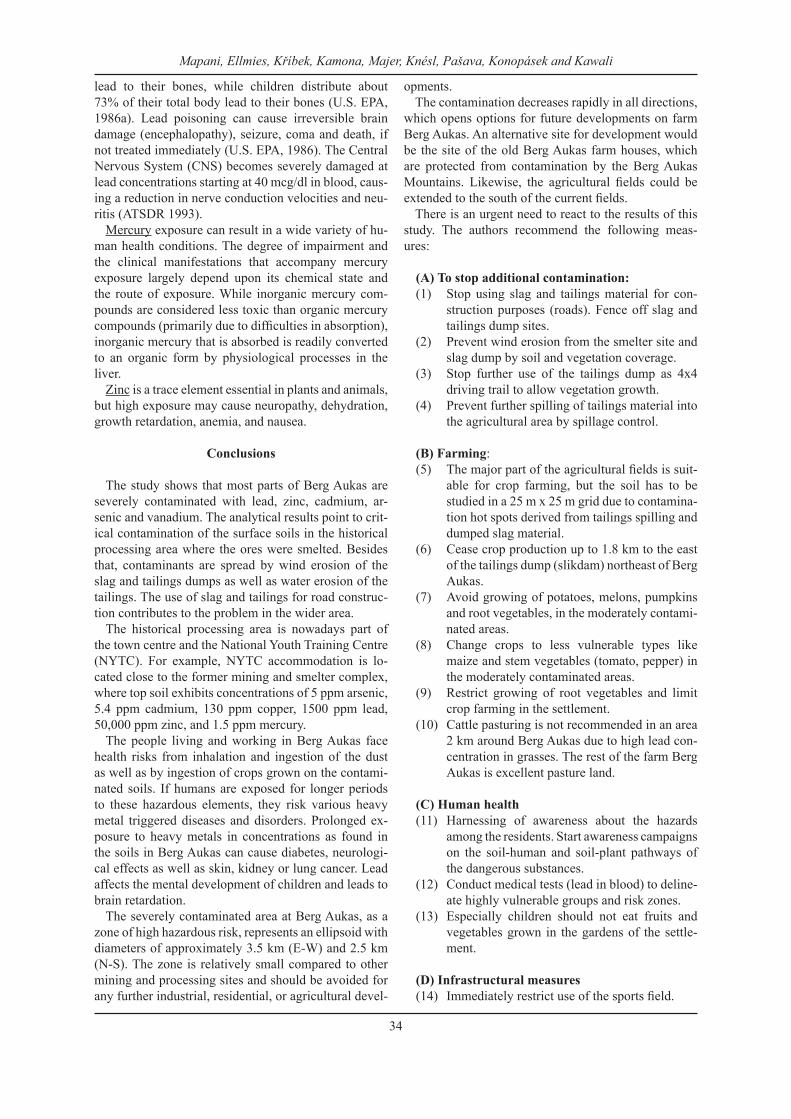
The pH of the water samples ranges from 6.8 to 8.1. The Namibian Guideline Values for drinking water (DWA, 1999) range between pH 6 and 9.
The water samples show electrical conductivities (EC) ranging from 74 to 393 mS/m. The limits for wa-ter of excellent quality (Group A) and of good quality (Group B) are 150 mS/m and 300 mS/m, respectively. Consumption of water above 300mS/m (Group C) is considered as low health risk.
Almost all the water samples from Berg Aukas are of excellent quality in terms of conductivity with the exception of three water samples, i.e. samples from borehole 63400 (15 m and 30 m sampling depth) and borehole 81270. The EC of the samples from the 15 m sampling depth of boreholes 63400 and 81270 fall into Group B (i.e. 207 and 172 mS/m, respectively),
Figure 3. Location of water sampling in the surroundings of Berg Aukas
Human Health Risks
27
while the sample from 30 m sampling depth of bore-hole 63400 has an EC of 393 mS/m, indicating a low health risk.
The sample from the NYS irrigation scheme has an EC of 85 mS/m. This is in the same range as previous analyses in June 2005 (85 mS/m) and in August 2007 (89 mS/m) (GSN Environmental Monitoring Series, No18).
Conclusion on groundwater quality
In general, the groundwater in the Berg Aukas and the surrounding areas does not show any significant signs of contamination from the past mining activities. It is of excellent to acceptable quality according to the Na-mibian Guideline Values for drinking water. Although the soil in the mining area is highly contaminated, the groundwater does not reflect those contaminants. The groundwater is naturally protected by the carbonate containing host rocks. The metals are kept immobile in the upper soil horizons due to the relatively high pH of the soil.
Trace metals are only detectable in the water which is pumped directly from the old Berg Aukas mine shaft, and which is used for irrigation at the National Youth Service agricultural fields and human consumption in the settlement. However, arsenic, cadmium and lead values are far below the limits of Group A (“excellent quality”) of the Namibian Guideline Values for drink-ing water. Only zinc values are with 1.7 mg/l slightly elevated in one water sample, marking it as Group B (“acceptable quality”). Based on the analysed metal concentrations, the Berg Aukas tap water is safe for hu-man consumption and no health risks can be expected by using the water for vegetable irrigation.
The water quality is compromised by elevated salinity in some of the boreholes. Magnesium and sodium chlo-ride are naturally occurring and can not be attributed to contamination of groundwater by human activities.
Soil sampling and analytical methods
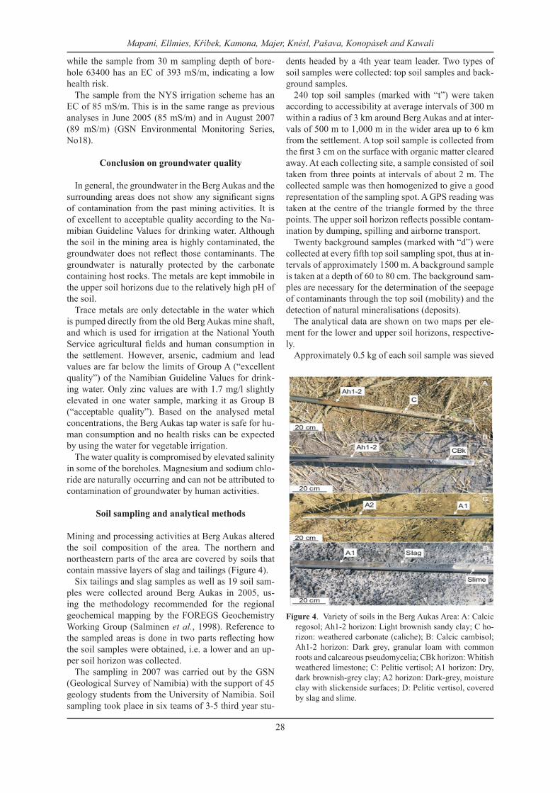
Mining and processing activities at Berg Aukas altered the soil composition of the area. The northern and northeastern parts of the area are covered by soils that contain massive layers of slag and tailings (Figure 4).
Six tailings and slag samples as well as 19 soil sam-ples were collected around Berg Aukas in 2005, us-ing the methodology recommended for the regional geochemical mapping by the FOREGS Geochemistry Working Group (Salminen et al., 1998). Reference to the sampled areas is done in two parts reflecting how the soil samples were obtained, i.e. a lower and an up-per soil horizon was collected.
The sampling in 2007 was carried out by the GSN (Geological Survey of Namibia) with the support of 45 geology students from the University of Namibia. Soil sampling took place in six teams of 3-5 third year stu-
dents headed by a 4th year team leader. Two types of soil samples were collected: top soil samples and back-ground samples.
240 top soil samples (marked with “t”) were taken according to accessibility at average intervals of 300 m within a radius of 3 km around Berg Aukas and at inter-vals of 500 m to 1,000 m in the wider area up to 6 km from the settlement. A top soil sample is collected from the first 3 cm on the surface with organic matter cleared away. At each collecting site, a sample consisted of soil taken from three points at intervals of about 2 m. The collected sample was then homogenized to give a good representation of the sampling spot. A GPS reading was taken at the centre of the triangle formed by the three points. The upper soil horizon reflects possible contam-ination by dumping, spilling and airborne transport.
Twenty background samples (marked with “d”) were collected at every fifth top soil sampling spot, thus at in-tervals of approximately 1500 m. A background sample is taken at a depth of 60 to 80 cm. The background sam-ples are necessary for the determination of the seepage of contaminants through the top soil (mobility) and the detection of natural mineralisations (deposits).
The analytical data are shown on two maps per ele-ment for the lower and upper soil horizons, respective-ly.
Approximately 0.5 kg of each soil sample was sieved
Figure 4. Variety of soils in the Berg Aukas Area: A: Calcic regosol; Ah1-2 horizon: Light brownish sandy clay; C ho-rizon: weathered carbonate (caliche); B: Calcic cambisol; Ah1-2 horizon: Dark grey, granular loam with common roots and calcareous pseudomycelia; CBk horizon: Whitish weathered limestone; C: Pelitic vertisol; A1 horizon: Dry, dark brownish-grey clay; A2 horizon: Dark-grey, moisture clay with slickenside surfaces; D: Pelitic vertisol, covered by slag and slime.
Mapani, Ellmies, Kříbek, Kamona, Majer, Knésl, Pašava, Konopásek and Kawali
28
to <0.2 mm. The fraction of < 0.2 mm was homogenized in an agate ball mill and the fraction < 0.063 mm was used for analyses. One gram of sample and 50 ml of a solution of HNO3 and HCl in the ratio 1:9 were used to prepare a leachate.
Trace elements of 19 soil samples were determined in the laboratory of the Czech Geological Survey (af-ter the methodology of Dempírová and Vitková, 2002), and at Charles University, Prague. Fe, Cd, Cu, Mo, Pb and Zn were analysed using flame atomic absorption spectroscopy (FAAS) with a PE 4000 spectrometer. Arsenic was determined by hydrite generation atomic absorption spectrometry (HGAAS) using the PE 503 equipment. Hg was analysed mercurometrically, using an AMA 254 analyser. The amount of total carbon was determined using the ELTRA CS 500 equipment. Sam-ples were combusted, and the quantity of the resulting CO2 was measured using an IR detector. The amount of carbonate carbon was determined using the Cou-lomat 7021 equipment. Samples were decomposed in the concentrated solution of H3PO4, and the amount of liberated CO2 was recalculated to that of carbonate car-bon (Ccarb). The amount of organic carbon (Corg) was determined by subtraction of carbonate carbon from total carbon content (Ctot): Corg = Ctot – Ccarb. Total sulphur (Stot) was determined on the ELTRA CS 500 equipment. Samples were combusted at a temperature of 1450°C, and the amount of released SO2 was deter-mined by an infrared detector.
The 260 soil samples of the sampling campaign in 2007 were analysed using a portable x-ray fluorescence (XRF) spectrometer XLt 700 Series Environmental An-alyzer Version 4.2 of NITON Corporation, USA. The instrument is pre-calibrated by the manufacturer, and the measurements taken were compared with readings from international standard samples (NIST 2709, NIST 2710, RCRA and others). The samples were analysed for As, Cu, Pb, V and Zn only. The detection limits vary between 10 and 30 mg/kg for the elements of concern. The confidence intervals (2 sigma; 95%) depend on the measuring time and typically range from ±5 to ±50% for a measuring time of 60 seconds.
Results of soils analyses
The tailings material contains very high amounts of zinc, vanadium, cadmium, arsenic and mercury (Table 1). In contrast, the lead concentrations are low. Approx-imately 18 wt. % of the tailings consists of particles of less than 8 μm in diameter (PM8). These particles pose the most serious health effects as they enter the lungs.
The slag is rich in zinc, lead, vanadium, copper and arsenic (Table 1). The amount of PM8 particles in the slag dust is low (1.3 wt.%).
The analytical results for the soil samples are present-ed in the form of distribution maps of the pollutants. The maps for As, Cd, Hg and V were produced with SURFER of Golden Software Inc. ArcGIS was used to
produce distribution maps for Cu, Pb and Zn.
Arsenic
In the lower soil horizon, contents of arsenic are gen-erally low (median: 0.89 ppm, maximum: 9.62 ppm) (Figure 5). Higher concentrations (> 2.6 ppm) were de-tected in the area of the former mining and processing complex and eastward (downwind) of the slime dams. The elevated concentrations trace back to an infiltra-tion of arsenic-rich solution from the top soil. The me-dian content of As in the top soil is one order higher (4.99 ppm) compared with the lower soil horizon, and maximum values are two orders higher (363 ppm) (Fig-ure 6).
Cadmium
Concentrations of cadmium in the lower soil horizons are very low (median: >0.8 ppm, maximum: 7.8 ppm) (Appendix 2). Two areas of slightly higher cadmium values (from 2.3 to 5.3 ppm Cd) are located in the former mining and metallurgical complex. The cadmium con-centration in the upper soil horizon is much higher (me-dian: 5.4 ppm, maximum value: 387 ppm) (Appendix 2). It is important to note that elevated concentrations of cadmium in the upper soil horizon encircle the whole area of Berg Aukas and extend towards the east. The large-scale contamination can not be explained by dust fall-out from mining operations and slime deposits. It is probably a result of emissions from the roasting of ores in the past.
Copper
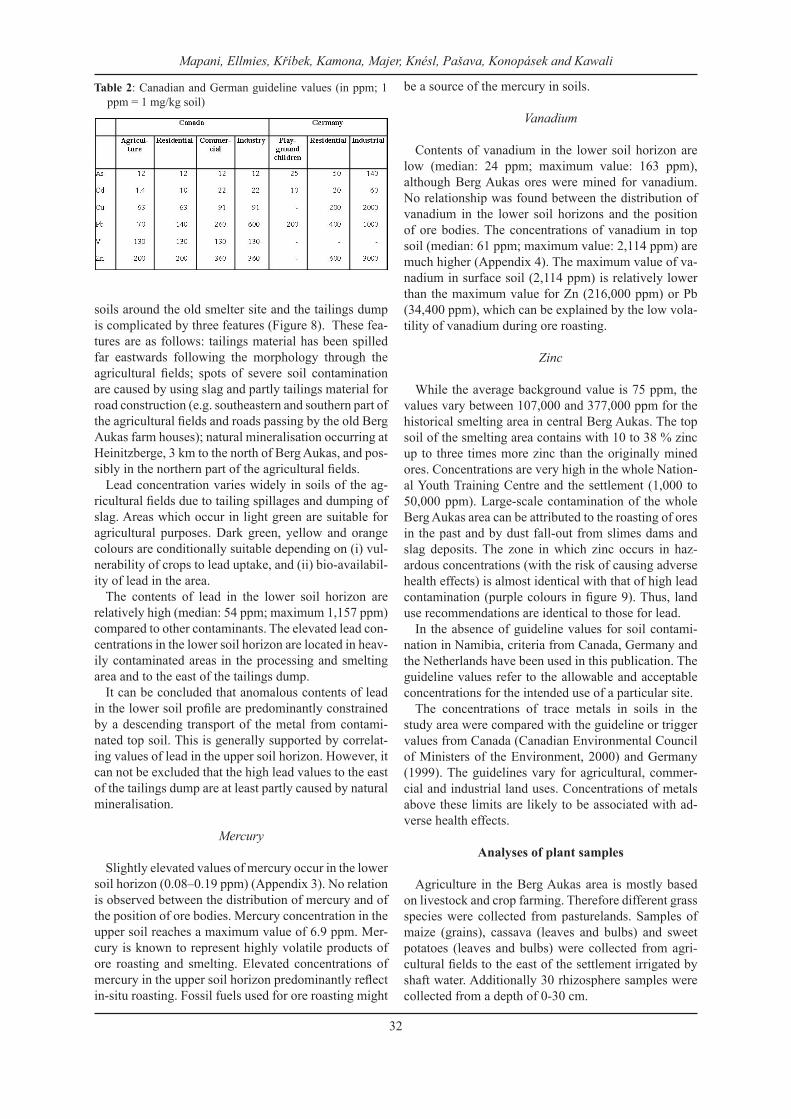
Contents of copper in the lower soil horizon are rela-tively low (median: 14 ppm), which corresponds to the low values of copper in ores. Concentrations of copper in surface soils range from 6 to 327 ppm (median: 28 ppm), and are only slightly higher compared with the lower soil horizon. The distribution of Cu can reflect both the position of ore bodies as well as the extent of contamination from the surface (Figure 7).
Human Health Risks
29
Table 1: Average chemical composition of tailings and slags at Berg Aukas
tailings slagsCtot (wt. %) 10.5 5.1Stot (wt. %) 0.034 0.110CO2 (wt. %) 37.16 6.04Corg (wt. %) 0.42 0.00V (ppm) 704 832Fe (wt. %) 1.68 3.98Cu (ppm) 184 640Zn (ppm) 52,100 22,400Mo (ppm) < 5 13Cd (ppm) 352 < 0.8Pb (ppm) < 10 11,600As (ppm) 109.1 383.7Hg (ppm) 2.228 0.028
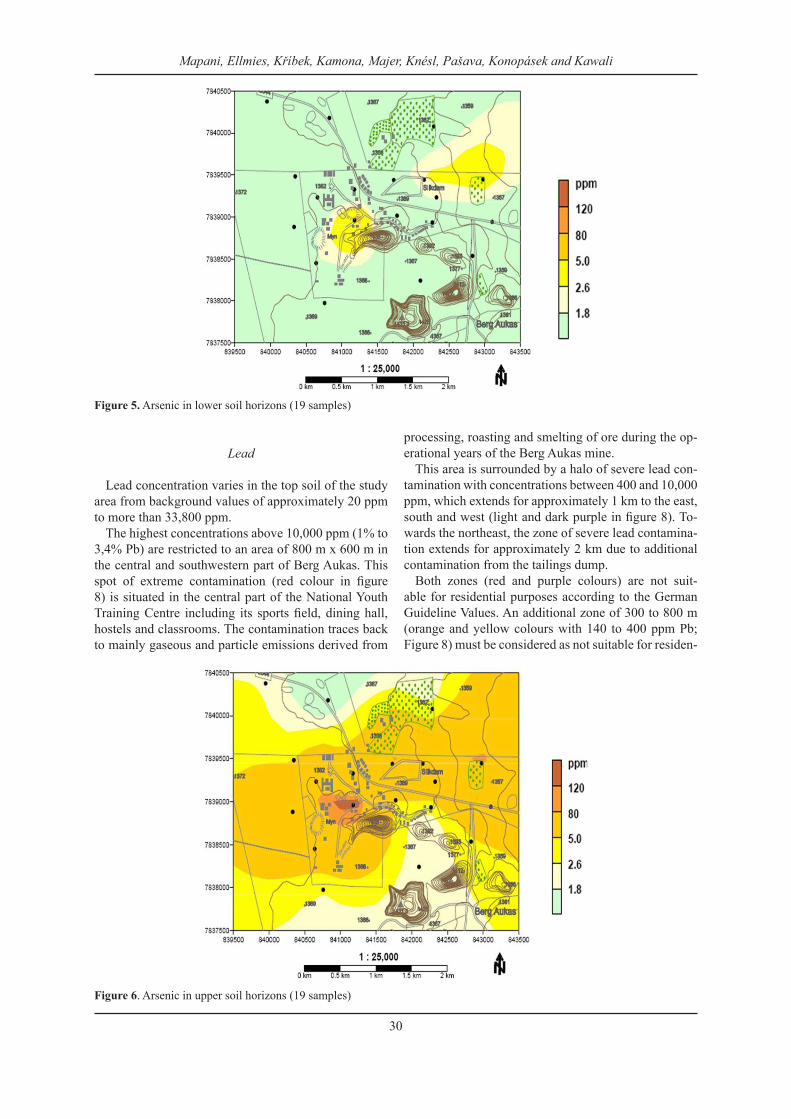
Figure 6. Arsenic in upper soil horizons (19 samples)
Mapani, Ellmies, Kříbek, Kamona, Majer, Knésl, Pašava, Konopásek and Kawali
30
Figure 5. Arsenic in lower soil horizons (19 samples)
Lead
Lead concentration varies in the top soil of the study area from background values of approximately 20 ppm to more than 33,800 ppm.
The highest concentrations above 10,000 ppm (1% to 3,4% Pb) are restricted to an area of 800 m x 600 m in the central and southwestern part of Berg Aukas. This spot of extreme contamination (red colour in figure 8) is situated in the central part of the National Youth Training Centre including its sports field, dining hall, hostels and classrooms. The contamination traces back to mainly gaseous and particle emissions derived from
processing, roasting and smelting of ore during the op-erational years of the Berg Aukas mine.
This area is surrounded by a halo of severe lead con-tamination with concentrations between 400 and 10,000 ppm, which extends for approximately 1 km to the east, south and west (light and dark purple in figure 8). To-wards the northeast, the zone of severe lead contamina-tion extends for approximately 2 km due to additional contamination from the tailings dump.
Both zones (red and purple colours) are not suit-able for residential purposes according to the German Guideline Values. An additional zone of 300 to 800 m (orange and yellow colours with 140 to 400 ppm Pb; Figure 8) must be considered as not suitable for residen-
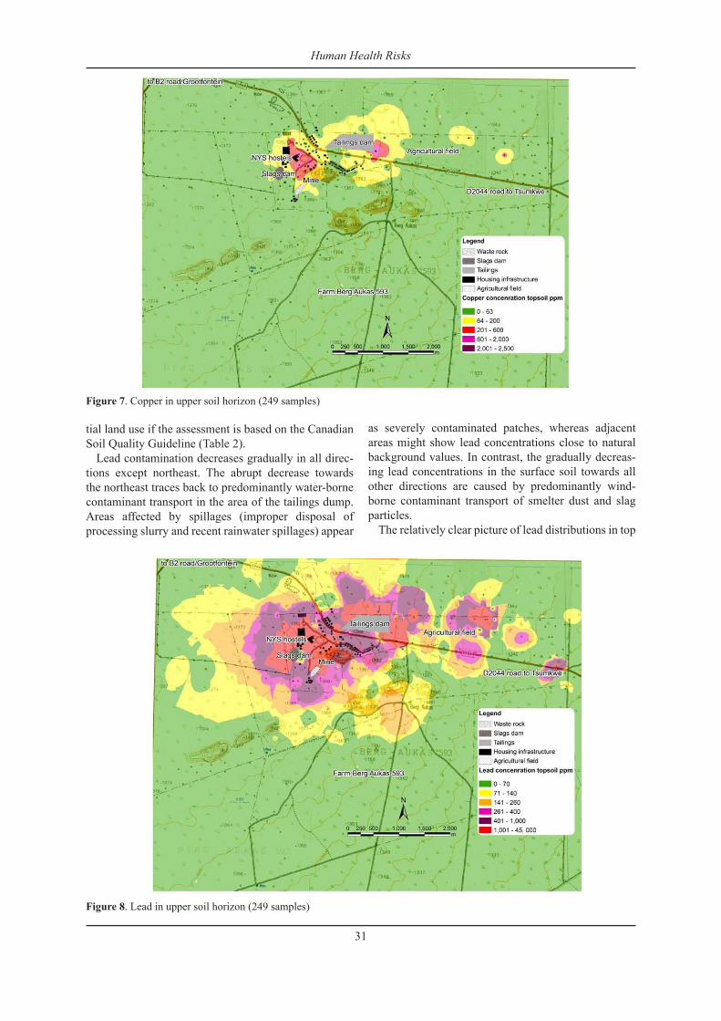
Figure 7. Copper in upper soil horizon (249 samples)
Human Health Risks
31
tial land use if the assessment is based on the Canadian Soil Quality Guideline (Table 2).
Lead contamination decreases gradually in all direc-tions except northeast. The abrupt decrease towards the northeast traces back to predominantly water-borne contaminant transport in the area of the tailings dump. Areas affected by spillages (improper disposal of processing slurry and recent rainwater spillages) appear
as severely contaminated patches, whereas adjacent areas might show lead concentrations close to natural background values. In contrast, the gradually decreas-ing lead concentrations in the surface soil towards all other directions are caused by predominantly wind-borne contaminant transport of smelter dust and slag particles.
The relatively clear picture of lead distributions in top
Figure 8. Lead in upper soil horizon (249 samples)
Mapani, Ellmies, Kříbek, Kamona, Majer, Knésl, Pašava, Konopásek and Kawali
32
Table 2: Canadian and German guideline values (in ppm; 1 ppm = 1 mg/kg soil)
soils around the old smelter site and the tailings dump is complicated by three features (Figure 8). These fea-tures are as follows: tailings material has been spilled far eastwards following the morphology through the agricultural fields; spots of severe soil contamination are caused by using slag and partly tailings material for road construction (e.g. southeastern and southern part of the agricultural fields and roads passing by the old Berg Aukas farm houses); natural mineralisation occurring at Heinitzberge, 3 km to the north of Berg Aukas, and pos-sibly in the northern part of the agricultural fields.
Lead concentration varies widely in soils of the ag-ricultural fields due to tailing spillages and dumping of slag. Areas which occur in light green are suitable for agricultural purposes. Dark green, yellow and orange colours are conditionally suitable depending on (i) vul-nerability of crops to lead uptake, and (ii) bio-availabil-ity of lead in the area.
The contents of lead in the lower soil horizon are relatively high (median: 54 ppm; maximum 1,157 ppm) compared to other contaminants. The elevated lead con-centrations in the lower soil horizon are located in heav-ily contaminated areas in the processing and smelting area and to the east of the tailings dump.
It can be concluded that anomalous contents of lead in the lower soil profile are predominantly constrained by a descending transport of the metal from contami-nated top soil. This is generally supported by correlat-ing values of lead in the upper soil horizon. However, it can not be excluded that the high lead values to the east of the tailings dump are at least partly caused by natural mineralisation.
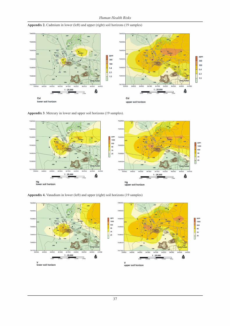
Mercury
Slightly elevated values of mercury occur in the lower soil horizon (0.08–0.19 ppm) (Appendix 3). No relation is observed between the distribution of mercury and of the position of ore bodies. Mercury concentration in the upper soil reaches a maximum value of 6.9 ppm. Mer-cury is known to represent highly volatile products of ore roasting and smelting. Elevated concentrations of mercury in the upper soil horizon predominantly reflect in-situ roasting. Fossil fuels used for ore roasting might
be a source of the mercury in soils.
Vanadium
Contents of vanadium in the lower soil horizon are low (median: 24 ppm; maximum value: 163 ppm), although Berg Aukas ores were mined for vanadium. No relationship was found between the distribution of vanadium in the lower soil horizons and the position of ore bodies. The concentrations of vanadium in top soil (median: 61 ppm; maximum value: 2,114 ppm) are much higher (Appendix 4). The maximum value of va-nadium in surface soil (2,114 ppm) is relatively lower than the maximum value for Zn (216,000 ppm) or Pb (34,400 ppm), which can be explained by the low vola-tility of vanadium during ore roasting.
Zinc
While the average background value is 75 ppm, the values vary between 107,000 and 377,000 ppm for the historical smelting area in central Berg Aukas. The top soil of the smelting area contains with 10 to 38 % zinc up to three times more zinc than the originally mined ores. Concentrations are very high in the whole Nation-al Youth Training Centre and the settlement (1,000 to 50,000 ppm). Large-scale contamination of the whole Berg Aukas area can be attributed to the roasting of ores in the past and by dust fall-out from slimes dams and slag deposits. The zone in which zinc occurs in haz-ardous concentrations (with the risk of causing adverse health effects) is almost identical with that of high lead contamination (purple colours in figure 9). Thus, land use recommendations are identical to those for lead.
In the absence of guideline values for soil contami-nation in Namibia, criteria from Canada, Germany and the Netherlands have been used in this publication. The guideline values refer to the allowable and acceptable concentrations for the intended use of a particular site.
The concentrations of trace metals in soils in the study area were compared with the guideline or trigger values from Canada (Canadian Environmental Council of Ministers of the Environment, 2000) and Germany (1999). The guidelines vary for agricultural, commer-cial and industrial land uses. Concentrations of metals above these limits are likely to be associated with ad-verse health effects.
Analyses of plant samples
Agriculture in the Berg Aukas area is mostly based on livestock and crop farming. Therefore different grass species were collected from pasturelands. Samples of maize (grains), cassava (leaves and bulbs) and sweet potatoes (leaves and bulbs) were collected from agri-cultural fields to the east of the settlement irrigated by shaft water. Additionally 30 rhizosphere samples were collected from a depth of 0-30 cm.
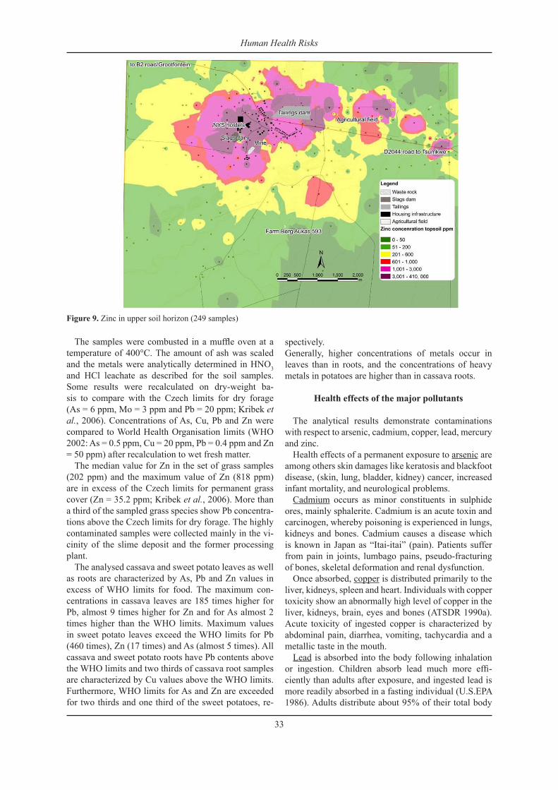
Figure 9. Zinc in upper soil horizon (249 samples)
Human Health Risks
33
The samples were combusted in a muffle oven at a temperature of 400°C. The amount of ash was scaled and the metals were analytically determined in HNO3 and HCl leachate as described for the soil samples. Some results were recalculated on dry-weight ba-sis to compare with the Czech limits for dry forage (As = 6 ppm, Mo = 3 ppm and Pb = 20 ppm; Kribek et al., 2006). Concentrations of As, Cu, Pb and Zn were compared to World Health Organisation limits (WHO 2002: As = 0.5 ppm, Cu = 20 ppm, Pb = 0.4 ppm and Zn = 50 ppm) after recalculation to wet fresh matter.
The median value for Zn in the set of grass samples (202 ppm) and the maximum value of Zn (818 ppm) are in excess of the Czech limits for permanent grass cover (Zn = 35.2 ppm; Kribek et al., 2006). More than a third of the sampled grass species show Pb concentra-tions above the Czech limits for dry forage. The highly contaminated samples were collected mainly in the vi-cinity of the slime deposit and the former processing plant.
The analysed cassava and sweet potato leaves as well as roots are characterized by As, Pb and Zn values in excess of WHO limits for food. The maximum con-centrations in cassava leaves are 185 times higher for Pb, almost 9 times higher for Zn and for As almost 2 times higher than the WHO limits. Maximum values in sweet potato leaves exceed the WHO limits for Pb (460 times), Zn (17 times) and As (almost 5 times). All cassava and sweet potato roots have Pb contents above the WHO limits and two thirds of cassava root samples are characterized by Cu values above the WHO limits. Furthermore, WHO limits for As and Zn are exceeded for two thirds and one third of the sweet potatoes, re-
spectively. Generally, higher concentrations of metals occur in leaves than in roots, and the concentrations of heavy metals in potatoes are higher than in cassava roots.
Health effects of the major pollutants
The analytical results demonstrate contaminations with respect to arsenic, cadmium, copper, lead, mercury and zinc.
Health effects of a permanent exposure to arsenic are among others skin damages like keratosis and blackfoot disease, (skin, lung, bladder, kidney) cancer, increased infant mortality, and neurological problems.
Cadmium occurs as minor constituents in sulphide ores, mainly sphalerite. Cadmium is an acute toxin and carcinogen, whereby poisoning is experienced in lungs, kidneys and bones. Cadmium causes a disease which is known in Japan as “Itai-itai” (pain). Patients suffer from pain in joints, lumbago pains, pseudo-fracturing of bones, skeletal deformation and renal dysfunction.
Once absorbed, copper is distributed primarily to the liver, kidneys, spleen and heart. Individuals with copper toxicity show an abnormally high level of copper in the liver, kidneys, brain, eyes and bones (ATSDR 1990a). Acute toxicity of ingested copper is characterized by abdominal pain, diarrhea, vomiting, tachycardia and a metallic taste in the mouth.
Lead is absorbed into the body following inhalation or ingestion. Children absorb lead much more effi-ciently than adults after exposure, and ingested lead is more readily absorbed in a fasting individual (U.S.EPA 1986). Adults distribute about 95% of their total body
lead to their bones, while children distribute about 73% of their total body lead to their bones (U.S. EPA, 1986a). Lead poisoning can cause irreversible brain damage (encephalopathy), seizure, coma and death, if not treated immediately (U.S. EPA, 1986). The Central Nervous System (CNS) becomes severely damaged at lead concentrations starting at 40 mcg/dl in blood, caus-ing a reduction in nerve conduction velocities and neu-ritis (ATSDR 1993).
Mercury exposure can result in a wide variety of hu-man health conditions. The degree of impairment and the clinical manifestations that accompany mercury exposure largely depend upon its chemical state and the route of exposure. While inorganic mercury com-pounds are considered less toxic than organic mercury compounds (primarily due to difficulties in absorption), inorganic mercury that is absorbed is readily converted to an organic form by physiological processes in the liver.
Zinc is a trace element essential in plants and animals, but high exposure may cause neuropathy, dehydration, growth retardation, anemia, and nausea.
Conclusions
The study shows that most parts of Berg Aukas are severely contaminated with lead, zinc, cadmium, ar-senic and vanadium. The analytical results point to crit-ical contamination of the surface soils in the historical processing area where the ores were smelted. Besides that, contaminants are spread by wind erosion of the slag and tailings dumps as well as water erosion of the tailings. The use of slag and tailings for road construc-tion contributes to the problem in the wider area.
The historical processing area is nowadays part of the town centre and the National Youth Training Centre (NYTC). For example, NYTC accommodation is lo-cated close to the former mining and smelter complex, where top soil exhibits concentrations of 5 ppm arsenic, 5.4 ppm cadmium, 130 ppm copper, 1500 ppm lead, 50,000 ppm zinc, and 1.5 ppm mercury.
The people living and working in Berg Aukas face health risks from inhalation and ingestion of the dust as well as by ingestion of crops grown on the contami-nated soils. If humans are exposed for longer periods to these hazardous elements, they risk various heavy metal triggered diseases and disorders. Prolonged ex-posure to heavy metals in concentrations as found in the soils in Berg Aukas can cause diabetes, neurologi-cal effects as well as skin, kidney or lung cancer. Lead affects the mental development of children and leads to brain retardation.
The severely contaminated area at Berg Aukas, as a zone of high hazardous risk, represents an ellipsoid with diameters of approximately 3.5 km (E-W) and 2.5 km (N-S). The zone is relatively small compared to other mining and processing sites and should be avoided for any further industrial, residential, or agricultural devel-
opments. The contamination decreases rapidly in all directions,
which opens options for future developments on farm Berg Aukas. An alternative site for development would be the site of the old Berg Aukas farm houses, which are protected from contamination by the Berg Aukas Mountains. Likewise, the agricultural fields could be extended to the south of the current fields.
There is an urgent need to react to the results of this study. The authors recommend the following meas-ures:
(A) To stop additional contamination: (1) Stop using slag and tailings material for con-
struction purposes (roads). Fence off slag and tailings dump sites.
(2) Prevent wind erosion from the smelter site and slag dump by soil and vegetation coverage.
(3) Stop further use of the tailings dump as 4x4 driving trail to allow vegetation growth.
(4) Prevent further spilling of tailings material into the agricultural area by spillage control.
(B) Farming: (5) The major part of the agricultural fields is suit-
able for crop farming, but the soil has to be studied in a 25 m x 25 m grid due to contamina-tion hot spots derived from tailings spilling and dumped slag material.
(6) Cease crop production up to 1.8 km to the east of the tailings dump (slikdam) northeast of Berg Aukas.
(7) Avoid growing of potatoes, melons, pumpkins and root vegetables, in the moderately contami-nated areas.
(8) Change crops to less vulnerable types like maize and stem vegetables (tomato, pepper) in the moderately contaminated areas.
(9) Restrict growing of root vegetables and limit crop farming in the settlement.
(10) Cattle pasturing is not recommended in an area 2 km around Berg Aukas due to high lead con-centration in grasses. The rest of the farm Berg Aukas is excellent pasture land.
(C) Human health(11) Harnessing of awareness about the hazards
among the residents. Start awareness campaigns on the soil-human and soil-plant pathways of the dangerous substances.
(12) Conduct medical tests (lead in blood) to deline-ate highly vulnerable groups and risk zones.
(13) Especially children should not eat fruits and vegetables grown in the gardens of the settle-ment.
(D) Infrastructural measures(14) Immediately restrict use of the sports field.
Mapani, Ellmies, Kříbek, Kamona, Majer, Knésl, Pašava, Konopásek and Kawali
34
(15) Any new development (industry, residential, agricultural) has to be avoided in red and purple zones.
(E) Trigger remediation(16) Contaminated urban areas have to be reha-
bilitated, if they are intended for future use as residential areas, e.g. by covering top soils with organic matter and vegetation.
(17) Removal of the severely contaminated top soil seems an option in some parts of the settle-ment, which are affected by airborne pollution. Here, the highly contaminated top soil can be removed and properly disposed.
(18) Soil removal and re-disposal is not an option in the central processing and smelting zone due to a deep penetration of the contaminants in the soil horizon, and thus, a tremendous volume of contaminated soil. Rehabilitation by reprocess-ing of the extremely contaminated soil (3% Pb, 30 % Zn) might be viable.
The Government of Namibia reacted without delay on the results of this study. After presentation of the results by the Ministry of Mines and Energy, Cabinet decided to take immediate action by evacuation of the hostels of the vocational school. Students are now accommodated in a safe environment at Rietfontein near Grootfontein. The follow-up on all measures (e.g. agricultural land use, food security, and remediation) is regularly moni-tored by Cabinet.
References
ATSDR (Agency for Toxic Substances and Disease Registry). 1989. Toxicological Profile for Arsenic. Agency for Toxic Substances and Disease Registry, U.S. Public Health Service, Atlanta, GA. ATSDR/TP-88/02.
ATSDR (Agency for Toxic Substances and Disease Registry). 1989a. Toxicological Profile for Mercury. ATSDR/U.S. Public Health Service.
ATSDR (Agency for Toxic Substances and Disease Registry). 1990. Toxicological Profile for Alumi-num. Agency for Toxic Substances and Disease Registry, U.S. Public Health Service, Atlanta, GA ATSDR/TP-88/01.
ATSDR (Agency for Toxic Substances and Disease Registry). 1990a. Toxicological Profile for Copper. Prepared by Syracuse Research Corporation for
ATSDR, U.S. Public Health Service under Contract 88-0608-2. ATSDR/TP-90-08.
ATSDR (Agency for Toxic Substances and disease Registry). 1993. Toxicological Profile for Lead. Update. Prepared by Clement International Corpo-ration under contract No. 205-88-0608 for ATSDR, U.S. Public Health Service, Atlanta, GA.
Bundesbodenschutz- und Altlastenverordnung, BBod-SchG (1999), BGBl I S., 1554, 63 p.
Centeno, J. 2001. Arsenic Poisoning Examples. Metals and Health and the environment conference pro-ceedings, June 28th 2001, Lusaka, Zambia.
GSN (Geological Survey of Namibia). 2007. Berg Au-kas - Human health risks associated with historic ore processing at Berg Aukas, Grootfontein area, Namibia, Environmental Monitoring Series No13, Geological Survey of Namibia, Windhoek, Decem-ber 2006, 29 p.
Knesl, I., Konopasek, J., Kribek, B., Majer, V., Pasava, J., Kamona, F., Mapani, B., Mufenda, M., Ellmies, R., Hahn, L., Ettler, V. 2006. Assessment of the min-ing and processing of ores on the environment in mining districts of Namibia: Kombat, Berg Aukas and Kaokoland. Czech Geological Survey, Record Office - File Report No. 1/2006, 166 p.
Misiewicz, J.E. 1988. The Geology and metallogeny of the Otavi Mountain Land, Damara Orogen, SWA/Namibia, with particular reference to the Berg Au-kas Zn-Pb-V deposit – A model of ore genesis. Un-publ. M. Sc. Thesis, Rhodes University, 143 p.
Ploethner, D., Teschner, M. and Schwartz, M.O. 1998. German-Namibian groundwater exploration project, Follow-up report vol 4. MS. Bundesanstalt für Geowissenschaften und Rohstoffe, Hannover, Ar-chives No. 117136, 70 p.
U.S. Environmental Protection Agency (EPA). 1986. Lead effects on cardiovascular function, early de-velopment, and stature: an addendum to EPA Air Quality Criteria for Lead (1986). In: Air Quality Criteria for Lead, Vol. I. Environmental Criteria and Assessment Office, Research Triangle Park, NC. EPA-600/8-83/028aF. Available from NTIS, Springfield, VA; PB87-142378. pp. A1-67.
U.S. EPA. 1987. Drinking Water Criteria Document for Copper. Prepared by the Office of Health and Envi-ronmental Assessment, Environmental Criteria and Assessment Office, Cincinnati, OH, for the Office of Drinking Water, Washington, DC. ECAO-CIN-417.
Human Health Risks
35
Appendix 1: Water analyses for shaft water from Berg Aukas and groundwater from farm Dornhügel in comparison with Na-mibian guideline values for drinking water
Mapani, Ellmies, Kříbek, Kamona, Majer, Knésl, Pašava, Konopásek and Kawali
36
Human Health Risks
37
Appendix 3. Mercury in lower and upper soil horizons (19 samples).
Appendix 2. Cadmium in lower (left) and upper (right) soil horizons (19 samples)
Appendix 4. Vanadium in lower (left) and upper (right) soil horizons (19 samples)
Ann
ex 1
: Fie
ld p
aram
eter
s for
the
wat
er sa
mpl
es in
Ber
g A
ukas
and
the
surr
ound
ing
farm
s.
Mapani, Ellmies, Kříbek, Kamona, Majer, Knésl, Pašava, Konopásek and Kawali
38
Human Health Risks
39
Annex 2: Analytical results for the groundwater samples from Berg Aukas.
Annex 2: Continued
Mapani, Ellmies, Kříbek, Kamona, Majer, Knésl, Pašava, Konopásek and Kawali
40