Embed Size (px)
DESCRIPTION
Innichen – Fischleintal Bike Store Tel. +39 0474 740 050 [email protected] Papin Sport Tel. +39 0474 913 450 www.papinsport.com Papin Sport Tel. +39 0474 913 450 www.papinsport.com Tel. +39 0474 710 310 Tel. +39 0474 913 149 Tel. +39 0474 972 132 Tel. +39 0474 745 136 Tel. +39 0474 748 660 Mair Freddy Tel. +39 0474 740 105 www.funactive.info Innichen | San Candido Trojer Martin Tel. +39 0474 913 216 www.trojer.info Toblach | Dobbiaco www.hochpustertal.info | www.altapusteria.info 10 10 12 1
Citation preview
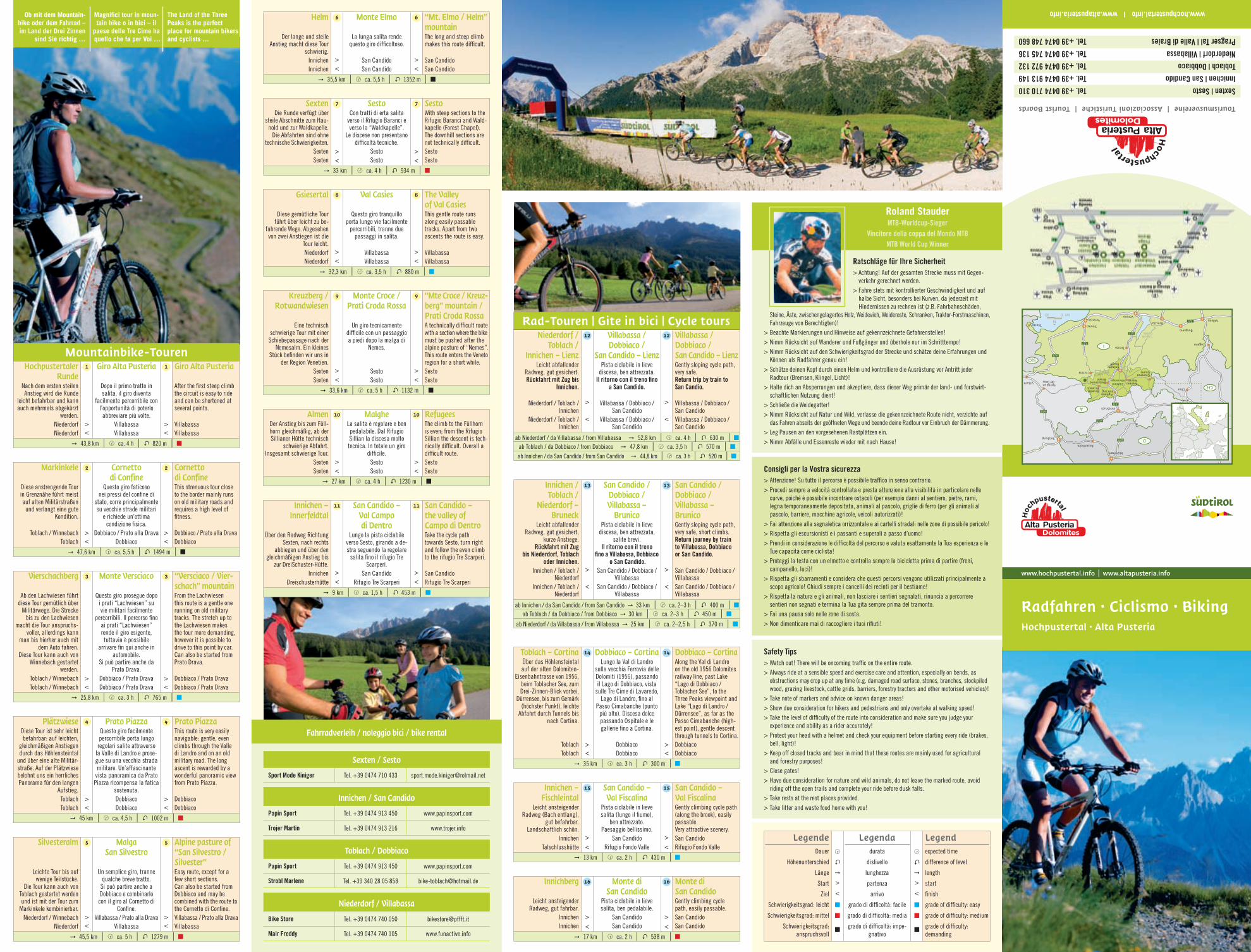
Mountainbike-TourenHochpustertaler
RundeNach dem ersten steilen Anstieg wird die Runde
leicht befahrbar und kann auch mehrmals abgekürzt
werden.Niederdorf Niederdorf
1
><
Giro Alta Pusteria
Dopo il primo tratto in salita, il giro diventa
facilmente percorribile con l’opportunità di poterlo abbreviare più volte.
VillabassaVillabassa
1
><
Giro Alta Pusteria
After the fi rst steep climb the circuit is easy to ride and can be shortened at several points.
VillabassaVillabassa
" 43,8 km | à ca. 4 h | L 820 m |
Markinkele
Diese anstrengende Tour in Grenznähe führt meist auf alten Militärstraßen
und verlangt eine gute Kondition.
Toblach / WinnebachToblach
2
><
Cornetto di Confine
Questo giro faticoso nei pressi del confi ne di
stato, corre principalmente su vecchie strade militari
e richiede un’ottima condizione fi sica.
Dobbiaco / Prato alla DravaDobbiaco
2
><
Cornetto di ConfineThis strenuous tour close to the border mainly runs on old military roads and requires a high level of fi tness.
Dobbiaco / Prato alla DravaDobbiaco
" 47,6 km | à ca. 5,5 h | L 1494 m |
Vierschachberg
Ab den Lachwiesen führt diese Tour gemütlich über
Militärwege. Die Strecke bis zu den Lachwiesen
macht die Tour anspruchs-voller, allerdings kann
man bis hierher auch mit dem Auto fahren.
Diese Tour kann auch von Winnebach gestartet
werden.Toblach / WinnebachToblach / Winnebach
3
><
Monte Versciaco
Questo giro prosegue dopo i prati “Lachwiesen” su vie militari facilmente
percorribili. Il percorso fi no ai prati “Lachwiesen” rende il giro esigente, tuttavia è possibile
arrivare fi n qui anche in automobile.
Si può partire anche da Prato Drava.
Dobbiaco / Prato DravaDobbiaco / Prato Drava
3
><
“Versciaco / Vier-schach” mountainFrom the Lachwiesen this route is a gentle one running on old military tracks. The stretch up to the Lachwiesen makes the tour more demanding, however it is possible to drive to this point by car.Can also be started from Prato Drava.
Dobbiaco / Prato DravaDobbiaco / Prato Drava
" 25,8 km | à ca. 3 h | L 765 m |
PlätzwieseDiese Tour ist sehr leicht befahrbar: auf leichten,
gleichmäßigen Anstiegen durch das Höhlensteintal
und über eine alte Militär-straße. Auf der Plätzwiese belohnt uns ein herrliches Panorama für den langen
Aufstieg. ToblachToblach
4
><
Prato PiazzaQuesto giro facilmente percorribile porta lungo
regolari salite attraverso la Valle di Landro e prose-gue su una vecchia strada militare. Un’affascinante
vista panoramica da Prato Piazza ricompensa la fatica
sostenuta.DobbiacoDobbiaco
4
><
Prato PiazzaThis route is very easily navigable: gentle, even climbs through the Valle di Landro and on an old military road. The long ascent is rewarded by a wonderful panoramic view from Prato Piazza.
DobbiacoDobbiaco
" 45 km | à ca. 4,5 h | L 1002 m |
Silvesteralm
Leichte Tour bis auf wenige Teilstücke.
Die Tour kann auch von Toblach gestartet werden und ist mit der Tour zum
Markinkele kombinierbar.Niederdorf / Winnebach
Niederdorf
5
><
Malga San Silvestro
Un semplice giro, tranne qualche breve tratto. Si può partire anche a Dobbiaco e combinarlo con il giro al Cornetto di
Confi ne.Villabassa / Prato alla Drava
Villabassa
5
><
Alpine pasture of “San Silvestro /Silvester”Easy route, except for a few short sections. Can also be started from Dobbiaco and may be combined with the route to the Cornetto di Confi ne.Villabassa / Prato alla DravaVillabassa
" 45,5 km | à ca. 5 h | L 1279 m |
Helm
Der lange und steile Anstieg macht diese Tour
schwierig.InnichenInnichen
6
><
Monte Elmo
La lunga salita rende questo giro diffi coltoso.
San CandidoSan Candido
6
><
“Mt. Elmo / Helm”mountainThe long and steep climb makes this route diffi cult.
San CandidoSan Candido
" 35,5 km | à ca. 5,5 h | L 1352 m |
SextenDie Runde verfügt über
steile Abschnitte zum Hau-nold und zur Waldkapelle.
Die Abfahrten sind ohne technische Schwierigkeiten.
SextenSexten
7
><
SestoCon tratti di erta salita
verso il Rifugio Baranci e verso la “Waldkapelle”.
Le discese non presentano diffi coltà tecniche.
SestoSesto
7
><
SestoWith steep sections to the Rifugio Baranci and Wald-kapelle (Forest Chapel). The downhill sections are not technically diffi cult.SestoSesto
" 33 km | à ca. 4 h | L 934 m |
Gsiesertal
Diese gemütliche Tour führt über leicht zu be-
fahrende Wege. Abgesehen von zwei Anstiegen ist die
Tour leicht.NiederdorfNiederdorf
8
><
Val Casies
Questo giro tranquillo porta lungo vie facilmente
percorribili, tranne due passaggi in salita.
VillabassaVillabassa
8
><
The Valley of Val CasiesThis gentle route runs along easily passable tracks. Apart from two ascents the route is easy.
VillabassaVillabassa
" 32,3 km | à ca. 3,5 h | L 880 m |
Kreuzberg /Rotwandwiesen
Eine technisch schwierige Tour mit einer Schiebepassage nach der
Nemesalm. Ein kleines Stück befi nden wir uns in
der Region Venetien.SextenSexten
9
><
Monte Croce /Prati Croda Rossa
Un giro tecnicamente diffi cile con un passaggio a piedi dopo la malga di
Nemes.
SestoSesto
9
><
“Mte Croce / Kreuz-berg” mountain / Prati Croda RossaA technically diffi cult routewith a section where the bikemust be pushed after the alpine pasture of “Nemes”. This route enters the Veneto region for a short while.SestoSesto
" 33,6 km | à ca. 5 h | L 1132 m |
AlmenDer Anstieg bis zum Füll-horn gleichmäßig, ab der Sillianer Hütte technisch
schwierige Abfahrt. Insgesamt schwierige Tour.
SextenSexten
10
><
MalgheLa salita è regolare e ben pedalabile. Dal Rifugio Sillian la discesa molto tecnica. In totale un giro
diffi cile. SestoSesto
10
><
RefugeesThe climb to the Füllhorn is even; from the Rifugio Sillian the descent is tech-nically diffi cult. Overall a diffi cult route.SestoSesto
" 27 km | à ca. 4 h | L 1230 m |
Innichen –Innerfeldtal
Über den Radweg Richtung Sexten, nach rechts
abbiegen und über den gleichmäßigen Anstieg bis
zur DreiSchuster-Hütte.Innichen
Dreischusterhütte
11
><
San Candido – Val Campo di Dentro
Lungo la pista ciclabile verso Sesto, girando a de-stra seguendo la regolare
salita fi no il rifugio Tre Scarperi.
San CandidoRifugio Tre Scarperi
11
><
San Candido –the valley of Campo di DentroTake the cycle path towards Sesto, turn right and follow the even climb to the rifugio Tre Scarperi.
San CandidoRifugio Tre Scarperi
" 9 km | à ca. 1,5 h | L 453 m |
Ob mit dem Mountain-bike oder dem Fahrrad – im Land der Drei Zinnen
sind Sie richtig …
Magnifi ci tour in moun-tain bike o in bici – il
paese delle Tre Cime ha quello che fa per Voi …
The Land of the Three Peaks is the perfect place for mountain bikers and cyclists …
Legende Dauer
Höhenunterschied
Länge
Start
Ziel
Schwierigkeitsgrad: leicht
Schwierigkeitsgrad: mittel
Schwierigkeitsgrad: anspruchsvoll
à
L
">
<
Legendadurata
dislivello
lunghezza
partenza
arrivo
grado di diffi coltà: facile
grado di diffi coltà: media
grado di diffi coltà: impe-gnativo
à
L
">
<
Legendexpected time
difference of level
length
start
fi nish
grade of diffi culty: easy
grade of diffi culty: medium
grade of diffi culty: demanding
Rad-Touren | Gite in bici | Cycle toursNiederdorf /
Toblach /Innichen – Lienz
Leicht abfallender Radweg, gut gesichert. Rückfahrt mit Zug bis
Innichen.
Niederdorf / Toblach / Innichen
Niederdorf / Toblach / Innichen
12
>
<
Villabassa / Dobbiaco /
San Candido – LienzPista ciclabile in lieve
discesa, ben attrezzata. Il ritorno con il treno fi no
a San Candido.
Villabassa / Dobbiaco / San Candido
Villabassa / Dobbiaco / San Candido
12
>
<
Villabassa / Dobbiaco /San Candido – LienzGently sloping cycle path, very safe. Return trip by train to San Candio.
Villabassa / Dobbiaco / San CandidoVillabassa / Dobbiaco / San Candido
ab Niederdorf / da Villabassa / from Villabassa " 52,8 km | à ca. 4 h | L 630 m | ab Toblach / da Dobbiaco / from Dobbiaco " 47,8 km | à ca. 3,5 h | L 570 m |
ab Innichen / da San Candido / from San Candido " 44,8 km | à ca. 3 h | L 520 m |
Innichen / Toblach /
Niederdorf – Bruneck
Leicht abfallender Radweg, gut gesichert,
kurze Anstiege. Rückfahrt mit Zug
bis Niederdorf, Toblach oder Innichen.
Innichen / Toblach / Niederdorf
Innichen / Toblach / Niederdorf
13
>
<
San Candido /Dobbiaco /Villabassa –
BrunicoPista ciclabile in lieve
discesa, ben attrezzata, salite brevi.
Il ritorno con il treno fi no a Villabassa, Dobbiaco
o San Candido.San Candido / Dobbiaco /
VillabassaSan Candido / Dobbiaco /
Villabassa
13
>
<
San Candido /Dobbiaco /Villabassa –BrunicoGently sloping cycle path, very safe, short climbs. Return journey by train to Villabassa, Dobbiaco or San Candido.
San Candido / Dobbiaco / VillabassaSan Candido / Dobbiaco / Villabassa
ab Innichen / da San Candido / from San Candido " 33 km | à ca. 2–3 h | L 400 m | ab Toblach / da Dobbiaco / from Dobbiaco " 30 km | à ca. 2–3 h | L 450 m |
ab Niederdorf / da Villabassa / from Villabassa " 25 km | à ca. 2–2,5 h | L 370 m |
Toblach – CortinaÜber das Höhlensteintal auf der alten Dolomiten-
Eisenbahntrasse von 1956, beim Toblacher See, zum Drei-Zinnen-Blick vorbei,
Dürrensee, bis zum Gemärk (höchster Punkt), leichte Abfahrt durch Tunnels bis
nach Cortina.
ToblachToblach
14
><
Dobbiaco – CortinaLungo la Val di Landro
sulla vecchia Ferrovia delle Dolomiti (1956), passando il Lago di Dobbiaco, vista
sulle Tre Cime di Lavaredo, Lago di Landro, fi no al
Passo Cimabanche (punto più alto). Discesa dolce passando Ospitale e le gallerie fi no a Cortina.
DobbiacoDobbiaco
14
><
Dobbiaco – CortinaAlong the Val di Landro on the old 1956 Dolomites railway line, past Lake “Lago di Dobbiaco / Toblacher See”, to the Three Peaks viewpoint and Lake “Lago di Landro / Dürrensee”, as far as the Passo Cimabanche (high-est point), gentle descent through tunnels to Cortina.DobbiacoDobbiaco
" 35 km | à ca. 3 h | L 300 m |
Innichen – Fischleintal
Leicht ansteigender Radweg (Bach entlang),
gut befahrbar. Landschaftlich schön.
InnichenTalschlusshütte
15
><
San Candido –Val Fiscalina
Pista ciclabile in lieve salita (lungo il fi ume),
ben attrezzato. Paesaggio bellissimo.
San CandidoRifugio Fondo Valle
15
><
San Candido –Val FiscalinaGently climbing cycle path (along the brook), easily passable. Very attractive scenery.San CandidoRifugio Fondo Valle
" 13 km | à ca. 2 h | L 430 m |
Innichberg
Leicht ansteigender Radweg, gut fahrbar.
InnichenInnichen
16
><
Monte di San Candido
Pista ciclabile in lieve salita, ben pedalabile.
San CandidoSan Candido
16
><
Monte di San CandidoGently climbing cycle path, easily passable.San CandidoSan Candido
" 17 km | à ca. 2 h | L 538 m |
Ratschläge für Ihre Sicherheit > Achtung! Auf der gesamten Strecke muss mit Gegen- verkehr gerechnet werden. > Fahre stets mit kontrollierter Geschwindigkeit und auf halbe Sicht, besonders bei Kurven, da jederzeit mit Hindernissen zu rechnen ist (z.B. Fahrbahnschäden, Steine, Äste, zwischengelagertes Holz, Weidevieh, Weideroste, Schranken, Traktor-Forstmaschinen, Fahrzeuge von Berechtigten)!> Beachte Markierungen und Hinweise auf gekennzeichnete Gefahrenstellen!> Nimm Rücksicht auf Wanderer und Fußgänger und überhole nur im Schritttempo!> Nimm Rücksicht auf den Schwierigkeitsgrad der Strecke und schätze deine Erfahrungen und Können als Radfahrer genau ein!> Schütze deinen Kopf durch einen Helm und kontrolliere die Ausrüstung vor Antritt jeder Radtour (Bremsen, Klingel, Licht)!> Halte dich an Absperrungen und akzeptiere, dass dieser Weg primär der land- und forstwirt- schaftlichen Nutzung dient!> Schließe die Weidegatter!> Nimm Rücksicht auf Natur und Wild, verlasse die gekennzeichnete Route nicht, verzichte auf das Fahren abseits der geöffneten Wege und beende deine Radtour vor Einbruch der Dämmerung.> Leg Pausen an den vorgesehenen Rastplätzen ein.> Nimm Abfälle und Essenreste wieder mit nach Hause!
Safety Tips> Watch out! There will be oncoming traffi c on the entire route.> Always ride at a sensible speed and exercise care and attention, especially on bends, as obstructions may crop up at any time (e.g. damaged road surface, stones, branches, stockpiled wood, grazing livestock, cattle grids, barriers, forestry tractors and other motorised vehicles)! > Take note of markers and advice on known danger areas!> Show due consideration for hikers and pedestrians and only overtake at walking speed!> Take the level of diffi culty of the route into consideration and make sure you judge your experience and ability as a rider accurately!> Protect your head with a helmet and check your equipment before starting every ride (brakes, bell, light)!> Keep off closed tracks and bear in mind that these routes are mainly used for agricultural and forestry purposes!> Close gates!> Have due consideration for nature and wild animals, do not leave the marked route, avoid riding off the open trails and complete your ride before dusk falls.> Take rests at the rest places provided.> Take litter and waste food home with you!
Roland StauderMTB-Worldcup-Sieger
Vincitore della coppa del Mondo MTBMTB World Cup Winner
Consigli per la Vostra sicurezza> Attenzione! Su tutto il percorso è possibile traffi co in senso contrario.> Procedi sempre a velocità controllata e presta attenzione alla visibilità in particolare nelle curve, poiché è possibile incontrare ostacoli (per esempio danni al sentiero, pietre, rami, legna temporaneamente depositata, animali al pascolo, griglie di ferro (per gli animali al pascolo, barriere, macchine agricole, veicoli autorizzati)!> Fai attenzione alla segnaletica orrizzontale e ai cartelli stradali nelle zone di possibile pericolo!> Rispetta gli escursionisti e i passanti e superali a passo d’uomo!> Prendi in considerazione le diffi coltà del percorso e valuta esattamente la Tua esperienza e le Tue capacità come ciclista!> Proteggi la testa con un elmetto e controlla sempre la bicicletta prima di partire (freni, campanello, luci)!> Rispetta gli sbarramenti e considera che questi percorsi vengono utilizzati principalmente a scopo agricolo! Chiudi sempre i cancelli dei recinti per il bestiame!> Rispetta la natura e gli animali, non lasciare i sentieri segnalati, rinuncia a percorrere sentieri non segnati e termina la Tua gita sempre prima del tramonto.> Fai una pausa solo nelle zone di sosta.> Non dimenticare mai di raccogliere i tuoi rifi uti!
Tourismusvereine | Associazioni Turistiche | Tourist Boards
Sexten | SestoInnichen | San CandidoToblach | DobbiacoNiederdorf | VillabassaPragser Tal | Valle di Braies
Tel. +39 0474 710 310Tel. +39 0474 913 149Tel. +39 0474 972 132Tel. +39 0474 745 136Tel. +39 0474 748 660
www.hochpustertal.info | www.altapusteria.info
Radfahren · Ciclismo · BikingHochpustertal · Alta Pusteria
www.hochpustertal.info | www.altapusteria.info
Sexten / Sesto
Sport Mode Kiniger Tel. +39 0474 710 433 [email protected]
Innichen / San Candido
Papin Sport Tel. +39 0474 913 450 www.papinsport.com
Trojer Martin Tel. +39 0474 913 216 www.trojer.info
Toblach / Dobbiaco
Papin Sport Tel. +39 0474 913 450 www.papinsport.com
Strobl Marlene Tel. +39 340 28 05 858 [email protected]
Niederdorf / Villabassa
Bike Store Tel. +39 0474 740 050 [email protected]
Mair Freddy Tel. +39 0474 740 105 www.funactive.info
Fahrradverleih / noleggio bici / bike rental
AUTONOME PROVINZ
BOZEN - SÜDTIROL
Abteilung Mobilität
PROVINCIA AUTONOMA
DI BOLZANO - ALTO ADIGE
Ripartizione MobilitàAUTONOME PROVINZ
BOZEN - SÜDTIROL
Abteilung Mobilität
PROVINCIA AUTONOMA
DI BOLZANO - ALTO ADIGE
Ripartizione Mobilità
Drau-UrsprungSorgenti d. Drava
Drau - Drava
HaunoldhütteRif. Baranci
Rif. Jora Hütte
JägerhütteBaita d.Cacciatore
Kleinmarerhof
Rif.Gröberhütte
GasthofJaufen Rist.Kahi
SeeschupfeIl Fienile
RistoranteSeerestaurant
JörgerhofGostnerhof
SeiterhofKurterhof
Drei-Zinnen-Blick
Rest. DürrenseeRist. Lago di Landro
Hennstoll
Burg
Rienz
GratschGrazze
Cappella Silvester Kapelle
St.Peteram Kofl
RatsbergMonterota
Alt-SchluderbachWildpark
Parco Fauna
Saghäuser
KandellenFrondeigen
1601
1650
1595
1241
1213
1259
I n n i c h b e r gMonte San Candido
HaunoldRocca dei Baranci
Neuner Kofel HaunoldköpflPicc. Rocca dei Baranci
GantkofelCima Ganda
1606
HelmMonte Elmo
H a s e l s b e r g
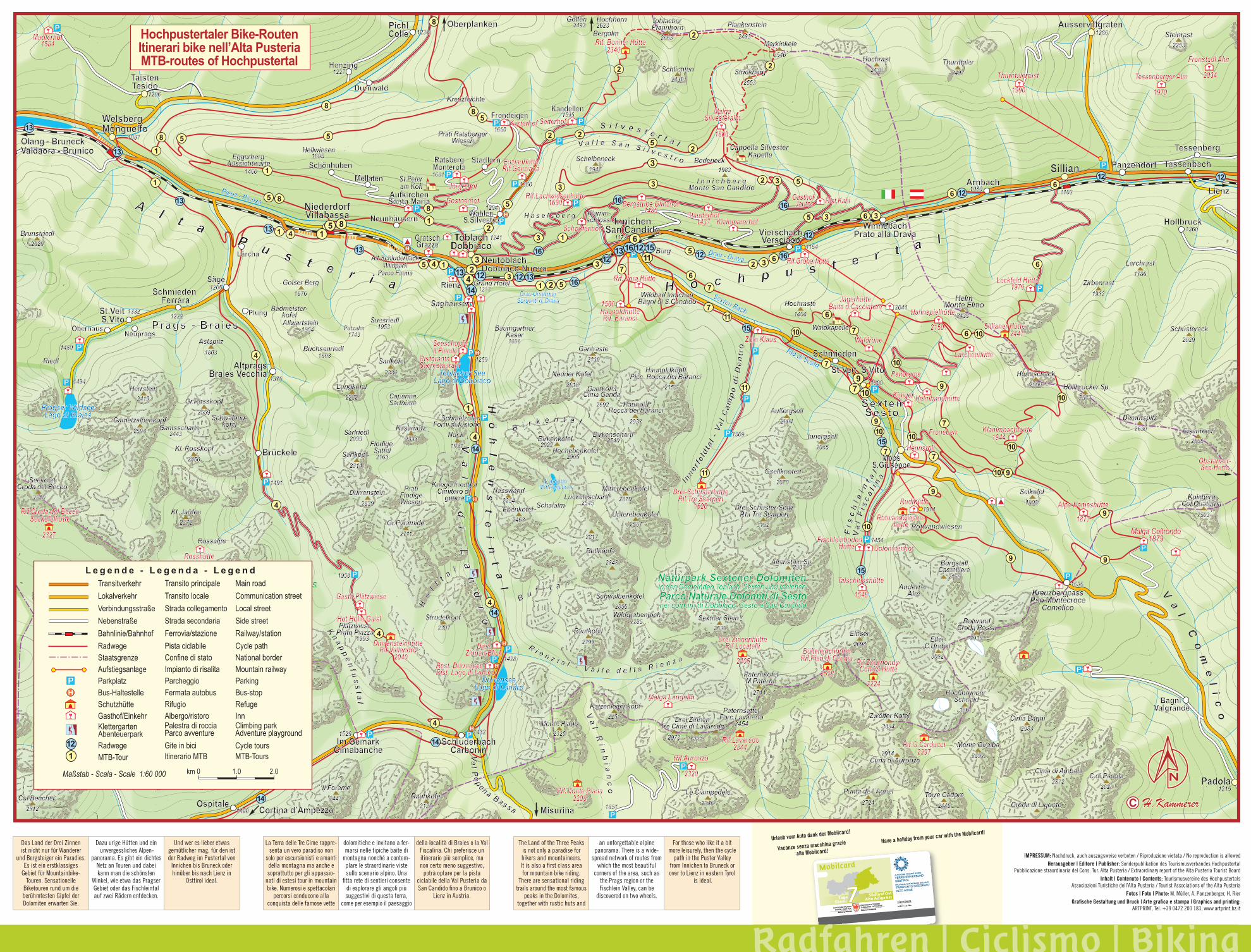
Hochpustertaler Bike-RoutenItinerari bike nell’Alta PusteriaMTB-routes of Hochpustertal
Transito principaleTransito localeStrada collegamentoStrada secondariaFerrovia/stazionePista ciclabileConfine di statoImpianto di risalitaParcheggioFermata autobusRifugioAlbergo/ristoro
TransitverkehrLokalverkehrVerbindungsstraßeNebenstraßeBahnlinie/BahnhofRadwegeStaatsgrenzeAufstiegsanlageParkplatzBus-HaltestelleSchutzhütteGasthof/EinkehrKlettergartenAbenteuerpark
Palestra di rocciaParco avventure
Main roadCommunication streetLocal streetSide streetRailway/stationCycle pathNational borderMountain railwayParkingBus-stopRefugeInnClimbing parkAdventure playground
MTB-Tour Itinerario MTB MTB-Tours
L e g e n d e - L e g e n d a - L e g e n d
km 0 1.0 2.0Maßstab - Scala - Scale 1:60 000
Radwege Gite in bici Cycle tours
IMPRESSUM: Nachdruck, auch auszugsweise verboten / Riproduzione vietata / No reproduction is allowedHerausgeber | Editore | Publisher: Sonderpublikation des Tourismusverbandes Hochpustertal
Pubblicazione straordinaria del Cons. Tur. Alta Pusteria / Extraordinary report of the Alta Pusteria Tourist Board Inhalt | Contenuto | Contents: Tourismusvereine des Hochpustertals
Associazioni Turistiche dell’Alta Pusteria / Tourist Associations of the Alta PusteriaFotos | Foto | Photo: M. Müller, A. Panzenberger, H. Rier
Grafi sche Gestaltung und Druck | Arte grafi ca e stampa | Graphics and printing:ARTPRINT, Tel. +39 0472 200 183, www.artprint.bz.it
Das Land der Drei Zinnen ist nicht nur für Wanderer
und Bergsteiger ein Paradies. Es ist ein erstklassiges
Gebiet für Mountainbike-Touren. Sensationelle
Biketouren rund um die berühmtesten Gipfel der Dolomiten erwarten Sie.
Dazu urige Hütten und ein unvergessliches Alpen-
panorama. Es gibt ein dichtes Netz an Touren und dabei kann man die schönsten
Winkel, wie etwa das Pragser Gebiet oder das Fischleintal auf zwei Rädern entdecken.
Und wer es lieber etwas gemütlicher mag, für den ist der Radweg im Pustertal von
Innichen bis Bruneck oder hinüber bis nach Lienz in
Osttirol ideal.
La Terra delle Tre Cime rappre-senta un vero paradiso non
solo per escursionisti e amanti della montagna ma anche e soprattutto per gli appassio-
nati di estesi tour in mountain bike. Numerosi e spettacolari
percorsi conducono alla conquista delle famose vette
dolomitiche e invitano a fer-marsi nelle tipiche baite di
montagna nonché a contem-plare le straordinarie viste sullo scenario alpino. Una
fi tta rete di sentieri consente di esplorare gli angoli più suggestivi di questa terra,
come per esempio il paesaggio
della località di Braies o la Val Fiscalina. Chi preferisce un itinerario più semplice, ma non certo meno suggestivo,
potrà optare per la pista ciclabile della Val Pusteria da San Candido fi no a Brunico o
Lienz in Austria.
The Land of the Three Peaks is not only a paradise for hikers and mountaineers. It is also a fi rst class area for mountain bike riding.
There are sensational riding trails around the most famous
peaks in the Dolomites, together with rustic huts and
an unforgettable alpine panorama. There is a wide-
spread network of routes from which the most beautiful
corners of the area, such as the Prags region or the Fischlein Valley, can be
discovered on two wheels.
For those who like it a bit more leisurely, then the cycle
path in the Puster Valley from Innichen to Bruneck or over to Lienz in eastern Tyrol
is ideal.
Radfahren | Ciclismo | BikingRadfahren | Ciclismo | BikingRadfahren | Ciclismo | BikingRadfahren | Ciclismo | BikingRadfahren | Ciclismo | BikingRadfahren | Ciclismo | BikingRadfahren | Ciclismo | Biking
Urlaub vom Auto dank der Mobilcard!
Vacanze senza macchina grazie
alla Mobilcard!
Have a holiday from your car with the Mobilcard!