1
Umgebungsplan Local area map Genau genommen gibt es am Hauptbahnhof zwei U-Bahnhöfe: Der ältere von beiden wurde am 18. Oktober 1980 eröffnet und ist inzwischen einer der meistfrequentierten U-Bahnhöfe im Netz. Hier verlassen U1 und U2 die gemeinsame Innenstadt-Strecke und verzweigen sich in Richtung Norden. Die vier Gleise verlaufen unter dem Bahnhofplatz; an deren Südende gelangt man über ein kleines Zwischengeschoss zum eine Ebene höher liegenden Bahnsteig der U4 und U5. Seit 10. März 1984 rollen von diesem Bahnhof unterhalb der Bayerstraße U-Bahnen zur Theresienwiese und weiter Rich-tung Westen. Von den U-Bahnlinien hat man nicht nur Anschluss zu Zügen und S-Bahnen, sondern auch zu zahlreichen Bus- und Tramlinien an der Oberfläche. 1925 ging es am Bahnhofplatz noch deutlich beschaulicher zu (Foto), doch ebenso wie heute fuhr die Trambahn vor dem Hertie-Haus und dem alten Telegraphenamt gegenüber vom Bahnhofsgebäude. Der U-Bahnhof Hauptbahnhof Hauptbahnhof Legende Key U-Bahnlinie Underground line U-Bahnhof Underground station Rolltreppe Escalator Buslinie Bus line Festtreppe Staircase Trambahnlinie Tram line Fußgängerzone Pedestrian Zone Aufzug Lift S-Bahnlinie Suburban railway Passage Passage Bike & Ride Bike & Ride Bahnlinie Railway Öffentliche Einrichtung Public building Parkhaus Parking garage Haltestelle (Tram/Bus) Stop (Tram/Bus) Kirche Church Polizei Police station Haltestelle (S-Bahn) Stop (S-Bahn) Ausgang Exit Theater Theater 46 Hausnummer House number Touristeninformation Tourist Information Foto: © MVG 1 2 Prielmayerstraße 3 Bereitschaftspraxis / Ärztlicher Notdienst Ausgang Exit F4 Schwanthalerstraße 62 Sozialbürgerhaus Ausgang Exit B7 Adolf-Kolping-Straße F7 – H7 Arcostraße H3 Arnulfstraße A2 – E4 Augustenstraße E1 Bahnhofplatz E5 – F4 Bayerstraße A6 – H5 Dachauer Straße E1 – E4 Denisstraße B1 – C1 Elisenstraße F3 – H4 Goethestraße D6 – D8 Herbststraße A1 – A2 Hirtenstraße C2 – E3 Hopfenstraße A2 – B1 Josephspitalstraße H8 Karlsplatz (Stachus) H5 – H6 Karlstraße F1 – H2 Katharina-von-Bora-Straße H1 – H2 Landwehrstraße A8 – G8 Straße Position Ausgang Street Map reference Exit Straße Position Ausgang Street Map reference Exit Straßenverzeichnis Street directory Luisenstraße E4 –G1 Luitpoldstraße F5 – G4 Marsstraße A1 – F3 Mittererstraße C6 – C7 Paul-Heyse-Straße B8 – C6 Paul-Heyse-Unterführung B5 – C3 Prielmayerstraße F4 – H5 Rundfunkplatz B1 – B2 Sankt-Pauls-Platz A8 Sankt-Paul-Straße A7 – A8 Schillerstraße E8 – F6 Schlosserstraße F6 – H6 Schützenstraße F5 – H6 Schwanthalerstraße A7 – H7 Seidlstraße B3 – D1 Senefelderstraße E6 – E7 Sonnenstraße H5 – H8 Sophienstraße F2-H3 Zweigstraße F6-F7 Orientierung leicht gemacht Easy orientation ! 1. Nutzen Sie das Straßenverzeichnis, um den passenden Ausgangsbuchstaben zu finden 1. Use the street directory to find the appropriate exit letter 2. Folgen Sie „Ihrem“ Buchstaben auf den Schildern im Bahnhof zum richtigen Ausgang 2. Follow „your“ letter in the signage to the right exit Cityring 68 Tierpark X98 Holzkirchner Bahnhof Cityring 58 Hauptbahnhof X98 Holzkirchner Bahnhof Cityring 68 via Goetheplatz, Kolumbusplatz Hauptbahnhof Süd Tierpark X98 Ostbahnhof 100 58 Cityring via Königsplatz, Universität Tierpark X98 Hauptbahnhof Nord Stadtrundfahrten Hauptbahnhof Nord Stadtrundfahrten Hauptbahnhof Nord Fürstenried West N41 Klinikum Großhadern N40 Karlsplatz (Stachus) Waldperlach N45 Dülferstraße N41 Kieferngarten N40 Karlsplatz (Stachus) Münchner Freiheit N45 Ostbahnhof 100 Cityring 58 Elisenstraße Hauptbahnhof Nord 100 Cityring 68 Elisenstraße Moosach N20 Moosach 20 Karlsplatz (Stachus) Effnerplatz N17 Amalienburgstraße N17 Schwanseestraße 18 Gondrellplatz 18 St. Emmeram 17 Amalienburgstraße 17 St. Emmeram 16 Romanplatz 16 Karlsplatz (Stachus) Petuelring N27 Großhesseloher Brücke N27 Sendlinger Tor 27 Petuelring 27 Karlsplatz (Stachus) Sendlinger Tor 28 Scheidplatz 28 St.-Veit-Straße N19 St.-Veit-Straße 21 Berg am Laim Bf. 19 Karlsplatz (Stachus) Pasing N19 Westfriedhof 21 Pasing 19 Karlsplatz (Stachus) Karlsplatz N20 Willibaldplatz 29 Lorem ipsum St.-Veit-Str. 21 Karlsplatz 20 Hauptbahnhof Nord Moosach N20 Hochschule München 29 Westfriedhof 21 Moosach 20 Hauptbahnhof Nord Karlsplatz N20 Willibaldplatz 29 St.-Veit-Str. 21 Karlsplatz 20 Karlstraße Moosach N20 Hochschule München 29 Westfriedhof 21 Moosach 20 Karlstraße Effnerplatz N17 St. Emmeram 17 St. Emmeram 16 Hauptbahnhof Nord Amalienburgstraße N17 Amalienburgstraße 17 Romanplatz 16 Hauptbahnhof Nord Amalienburgstraße N16 Amalienburgstraße 17 Romanplatz 16 Hopfenstraße Effnerplatz N17 St. Emmeram 17 St. Emmeram 16 Hopfenstraße Pasing N19 Pasing 19 Willibaldplatz 29 Gondrellplatz 18 Hauptbahnhof Süd St.-Veit-Straße N19 Berg am Laim Bf. 19 Hochschule München 29 Schwanseestraße 18 Hauptbahnhof Süd St.-Veit-Straße N19 Berg am Laim Bf. 19 Hochschule München 29 18 Schwanseestraße Holzkirchner Bahnhof Pasing N19 Pasing 19 Willibaldplatz 29 Gondrellplatz 18 Holzkirchner Bahnhof Hauptbahnhof Moosach N20 St.-Veit-Straße N19 Amalienburgstraße N17 Hochschule München 29 Moosach 20 Berg am Laim Bf. 19 Amalienburgstraße 17 Romanplatz 16 St. Emmeram 16 St. Emmeram 17 Pasing 19 Willibaldplatz 29 Effnerplatz N17 Pasing N19 Hauptbahnhof A F G D B E Lift zur U1/U2/U7/U8 Lift zur U1/U2/U7/U8 Lift zur U4/U5 U5 U5 U5 U4 U4 U4 U2 U2 U2 U1 U1 z 2 1 z U1 z U8 U8 U8 U7 U7 U7 31 12 41 1 7 2 2 4 1 3 3 21 Sendlinger Tor Hackerbrücke S t i g l m a i e r p l a t z Königsplatz Karlsplatz (Stachus) Hauptbahnhof Theresienwiese Karlsplatz (Stachus) Hauptbahnhof Hauptbahnhof München Central Station Holzkirchner Bahnhof Starnberger Flügelbahnhof Staatsministerium der Justiz (Justizpalast) Kunstpavillon Berufsbildungs- zentrum Gymnasium Bay. Blinden- und Sehbehindertenbund e.V. Kinder- und Jugendmuseum Referat für Gesundheit und Umwelt Referat für Bildung und Sport Sozialbürger- haus Kreisjugendring Grund- schule Goethe Institut Realschule Bayerischer Rundfunk Oberfinanz- direktion Oberlandes- gericht Bayerischer Verfassungs- gerichtshof Staatliche Antikensammlung Alter Botanischer Garten Neptun- brunnen Sozialreferat/ Stadtjugendamt Gewerk- schaftshaus Statistisches Amt Bereitschaftspraxis Ärztlicher Notdienst St. Bonifaz St. Paul Deutsches Theater Bayerstraße Sankt- Pauls-Platz Rundfunk- platz Karlsplatz (Stachus) Bahnhofplatz Sankt-Paul-Straße Adolf-Kolping-Straße Schillerstraße Senefelderstraße Goethestraße Mittererstraße Schwanthalerstraße Schwanthalerstraße Landwehrstraße Landwehrstraße Hopfenstraße Herbststraße Denisstraße Seidlstraße Hirtenstraße Karlstraße Katharina-von-Bora-Straße (ehem. Meiserstraße) Luitpoldstraße S o p h i e n s t r a ß e Arcostraße Elisenstraße Josephspital- straße Augusten- straße Schlosser- straße Marsstraße Rundfunk- platz Sankt- Pauls-Platz Karlsplatz (Stachus) Karl-Stützel- Platz Sonnenstraße Zweigstraße Elisenstraße Marsstraße Hirtenstraße Hopfenstraße Denisstraße Herbststraße Dachauer Straße Augusten- straße Arnulfstraße Arnulfstraße Marsstraße Seidlstraße Paul-Heyse-Unterführung Paul-Heyse-Straße Bahnhofplatz Luisenstraße Bayerstraße Bayerstraße Bayerstraße Sonnenstraße Karlstraße Arcostraße Katharina-von-Bora-Straße (ehem. Meiserstraße) Prielmayerstraße Luitpoldstraße Schützenstraße Schlosser- straße Josephspital- straße Zweigstraße Adolf-Kolping-Straße Schillerstraße Senefelderstraße Goethestraße Mittererstraße Landwehrstraße Landwehrstraße Schwanthalerstraße Schwanthalerstraße Sankt-Paul-Straße S o p h i e n s t r a ß e A 1 2 B C D E F G H 1 2 3 4 5 6 7 7 5 6 3 4 G D E F A B C 8 8 H N | Münchner Verkehrsgesellschaft mbH (MVG) | U-Bahnhof Hauptbahnhof HU | Stand: 2019-12-15 © 2013 0 50 100 150 200 Meter

N N2 Umgebungsplan - MVG · 1 3 3 21 or e S t i g l m a i e r p l a t z Knigsplat Karlsplat Stachus auptbahnhof Theresienwiese arlsplatz Stachus Hauptbahnhof Hauptbahnhof ünchen

  • Upload
    others

  • View
    1

  • Download
    0

Embed Size (px)

Citation preview

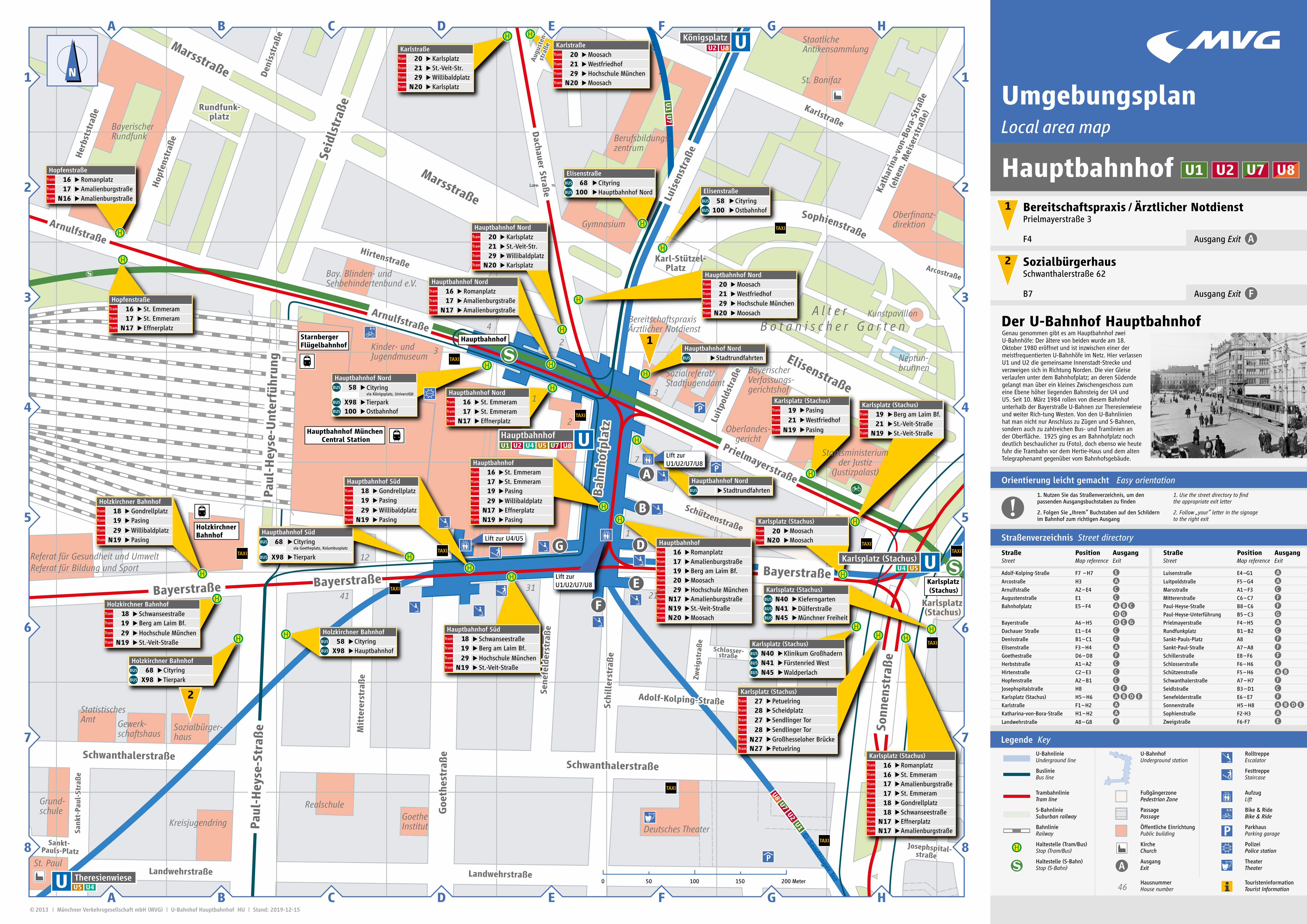
UmgebungsplanLocal area map

Genau genommen gibt es am Hauptbahnhof zwei U-Bahnhöfe: Der ältere von beiden wurde am 18. Oktober 1980 eröffnet und ist inzwischen einer der meistfrequentierten U-Bahnhöfe im Netz. Hier verlassen U1 und U2 die gemeinsame Innenstadt-Strecke und verzweigen sich in Richtung Norden. Die vier Gleise verlaufen unter dem Bahnhofplatz; an deren Südende gelangt man über ein kleines Zwischengeschoss zum eine Ebene höher liegenden Bahnsteig der U4 und U5. Seit 10. März 1984 rollen von diesem Bahnhof unterhalb der Bayerstraße U-Bahnen zur Theresienwiese und weiter Rich-tung Westen. Von den U-Bahnlinien hat man nicht nur Anschluss zu Zügen und S-Bahnen, sondern auch zu zahlreichen Bus- und Tramlinien an der Oberfläche. 1925 ging es am Bahnhofplatz noch deutlich beschaulicher zu (Foto), doch ebenso wie heute fuhr die Trambahn vor dem Hertie-Haus und dem alten Telegraphenamt gegenüber vom Bahnhofsgebäude.

Der U-Bahnhof Hauptbahnhof

Hauptbahnhof

Legende Key

U-BahnlinieUnderground line

U-BahnhofUnderground station

RolltreppeEscalator

BuslinieBus line

FesttreppeStaircase

TrambahnlinieTram line

FußgängerzonePedestrian Zone

AufzugLift

S-BahnlinieSuburban railway

PassagePassage

Bike & RideBike & Ride

BahnlinieRailway

Öffentliche EinrichtungPublic building

ParkhausParking garage

Haltestelle (Tram/Bus)Stop (Tram/Bus)

KircheChurch

PolizeiPolice station

Haltestelle (S-Bahn)Stop (S-Bahn)

AusgangExit

TheaterTheater

46HausnummerHouse number

TouristeninformationTourist Information

Fot

o: ©

MVG

1

2

Prielmayerstraße 3Bereitschaftspraxis / Ärztlicher Notdienst

Ausgang ExitF4

Schwanthalerstraße 62Sozialbürgerhaus

Ausgang ExitB7

Adolf-Kolping-Straße F7 – H7

Arcostraße H3

Arnulfstraße A2 – E4

Augustenstraße E1

Bahnhofplatz E5 – F4

Bayerstraße A6 – H5

Dachauer Straße E1 – E4

Denisstraße B1 – C1

Elisenstraße F3 – H4

Goethestraße D6 – D8

Herbststraße A1 – A2

Hirtenstraße C2 – E3

Hopfenstraße A2 – B1

Josephspitalstraße H8

Karlsplatz (Stachus) H5 – H6

Karlstraße F1 – H2 Katharina-von-Bora-Straße H1 – H2

Landwehrstraße A8 – G8

Straße Position AusgangStreet Map reference Exit

Straße Position AusgangStreet Map reference Exit

Straßenverzeichnis Street directory

Luisenstraße E4 –G1

Luitpoldstraße F5 – G4

Marsstraße A1 – F3

Mittererstraße C6 – C7

Paul-Heyse-Straße B8 – C6

Paul-Heyse-Unterführung B5 – C3

Prielmayerstraße F4 – H5

Rundfunkplatz B1 – B2

Sankt-Pauls-Platz A8

Sankt-Paul-Straße A7 – A8

Schillerstraße E8 – F6

Schlosserstraße F6 – H6

Schützenstraße F5 – H6

Schwanthalerstraße A7 – H7

Seidlstraße B3 – D1

Senefelderstraße E6 – E7

Sonnenstraße H5 – H8

Sophienstraße F2-H3

Zweigstraße F6-F7

Orientierung leicht gemacht Easy orientation

!1. Nutzen Sie das Straßenverzeichnis, um den passenden Ausgangsbuchstaben zu finden

1. Use the street directory to find the appropriate exit letter

2. Folgen Sie „Ihrem“ Buchstaben auf den Schildern im Bahnhof zum richtigen Ausgang

2. Follow „your“ letter in the signage to the right exit

Cityring68TierparkX98

Holzkirchner Bahnhof

Cityring58HauptbahnhofX98

Holzkirchner Bahnhof

Cityring68via Goetheplatz, Kolumbusplatz

Hauptbahnhof Süd

TierparkX98

Ostbahnhof100

58 Cityringvia Königsplatz, Universität

TierparkX98

Hauptbahnhof Nord

Stadtrundfahrten

Hauptbahnhof Nord

StadtrundfahrtenHauptbahnhof Nord

Fürstenried WestN41Klinikum GroßhadernN40

Karlsplatz (Stachus)

WaldperlachN45

DülferstraßeN41KieferngartenN40

Karlsplatz (Stachus)

Münchner FreiheitN45

Ostbahnhof100Cityring58

ElisenstraßeHauptbahnhof Nord100Cityring68

Elisenstraße

MoosachN20Moosach20

Karlsplatz (Stachus)

EffnerplatzN17AmalienburgstraßeN17

Schwanseestraße18Gondrellplatz18St. Emmeram17Amalienburgstraße17St. Emmeram16Romanplatz16

Karlsplatz (Stachus)PetuelringN27Großhesseloher BrückeN27

Sendlinger Tor27

Petuelring27Karlsplatz (Stachus)

Sendlinger Tor28

Scheidplatz28

St.-Veit-StraßeN19St.-Veit-Straße21Berg am Laim Bf.19

Karlsplatz (Stachus)

PasingN19

Westfriedhof21

Pasing19Karlsplatz (Stachus)

KarlsplatzN20Willibaldplatz29

Lorem ipsum

St.-Veit-Str.21Karlsplatz20

Hauptbahnhof Nord

MoosachN20Hochschule München29Westfriedhof 21Moosach20

Hauptbahnhof Nord

KarlsplatzN20Willibaldplatz29St.-Veit-Str.21Karlsplatz20

Karlstraße

MoosachN20Hochschule München29Westfriedhof21Moosach20

Karlstraße

EffnerplatzN17St. Emmeram17St. Emmeram16

Hauptbahnhof Nord

AmalienburgstraßeN17Amalienburgstraße17Romanplatz16

Hauptbahnhof Nord

AmalienburgstraßeN16Amalienburgstraße17Romanplatz16

Hopfenstraße

EffnerplatzN17St. Emmeram17St. Emmeram16

Hopfenstraße

PasingN19

Pasing19Willibaldplatz29

Gondrellplatz18Hauptbahnhof Süd

St.-Veit-StraßeN19

Berg am Laim Bf.19Hochschule München 29

Schwanseestraße18Hauptbahnhof Süd

St.-Veit-StraßeN19

Berg am Laim Bf.19Hochschule München29

18 SchwanseestraßeHolzkirchner Bahnhof

PasingN19

Pasing19Willibaldplatz29

Gondrellplatz18Holzkirchner Bahnhof

Hauptbahnhof

MoosachN20St.-Veit-StraßeN19AmalienburgstraßeN17Hochschule München29Moosach20Berg am Laim Bf.19Amalienburgstraße17Romanplatz16

St. Emmeram16St. Emmeram17Pasing19Willibaldplatz29EffnerplatzN17PasingN19

Hauptbahnhof

A

F

G D

B

E

Lift zur U1/U2/U7/U8

Lift zur U1/U2/U7/U8

Lift zur U4/U5

U5

U5

U5

U4

U4

U4

U2

U2

U2

U1

U1

z

2

1

z

U1

z

U8

U8

U8

U7

U7

U7

31

12

41

1

7

2

2

4

1

3

3

21

Sendlinger Tor

Hackerbrücke

Stiglmaierplatz

Königsplatz

Karlsplatz (Stachus)

Hauptbahnhof

Theresienwiese

Karlsplatz (Stachus)

Hauptbahnhof

Hauptbahnhof München Central Station

Holzkirchner Bahnhof

Starnberger Flügelbahnhof

Staatsministeriumder Justiz

(Justizpalast)

Kunstpavillon

Berufsbildungs-zentrum

Gymnasium

Bay. Blinden- undSehbehindertenbund e.V.

Kinder- und Jugendmuseum

Referat für Gesundheit und UmweltReferat für Bildung und Sport

Sozialbürger-haus

Kreisjugendring

Grund-schule

Goethe Institut

Realschule

BayerischerRundfunk

Oberfinanz-direktion

Oberlandes-gericht

BayerischerVerfassungs-gerichtshof

Staatliche Antikensammlung

A l t e r B o t a n i s c h e r G a r t e n

Neptun-brunnen

Sozialreferat/Stadtjugendamt

Gewerk-schaftshaus

Statistisches Amt

BereitschaftspraxisÄrztlicher Notdienst

St. Bonifaz

St. Paul

Deutsches Theater

Bayerstraße

Sankt-Pauls-Platz

Rundfunk- platz

Karlsplatz (Stachus)

Bah

nhof

plat

z

Sank

t-Pa

ul-S

traß

e

Adolf-Kolping-StraßeSchi

ller

stra

ße

Sene

feld

erst

raß

e

Goe

thes

traß

e

Mit

tere

rstr

aße

SchwanthalerstraßeSchwanthalerstraße

LandwehrstraßeLandwehrstraße

Hop

fens

traß

e

Her

bsts

traß

e

Den

isst

raße

Seid

lstr

aße

Hirtenstraße

Karlstraße

Kath

arin

a-vo

n-Bo

ra-S

traß

e

(ehe

m. M

eise

rstr

aße)

Luit

pold

stra

ße

Sophienstraße

Arcostraße

Elisenstraße

Josephspital- straße

Aug

uste

n- s

traß

e

Schlosser-straße

Marsstraße

Rundfunk- platz

Sankt-Pauls-Platz

Karlsplatz (Stachus)

Karl-Stützel- Platz

Sonn

enst

raß

e

Zwei

gstr

aße

Elisenstraße

Marsstraße

Hirtenstraße

Hop

fens

traß

e

Den

isst

raße

Her

bsts

traß

e

Dachauer Straß

e

Aug

uste

n- s

traß

e

Arnulfstraße

Arnulfstraße

Marsstraße

Seid

lstr

aße

Paul

-Hey

se-U

nter

führ

ung

Paul

-Hey

se-S

traß

e

Bah

nhof

plat

z

Luis

enst

raße

BayerstraßeBayerstraße Bayerstraße

Sonn

enst

raß

e

Karlstraße

Arcostraße

Kath

arin

a-vo

n-Bo

ra-S

traß

e

(ehe

m. M

eise

rstr

aße)

Prielmayerstraße

Luit

pold

stra

ße

Schützenstraße

Schlosser-straße

Josephspital- straße

Zwei

gstr

aße

Adolf-Kolping-StraßeSchi

ller

stra

ße

Sene

feld

erst

raß

e

Goe

thes

traß

e

Mit

tere

rstr

aße

LandwehrstraßeLandwehrstraße

SchwanthalerstraßeSchwanthalerstraße

Sank

t-Pa

ul-S

traß

e

Sophienstraße

A

1

2

B C D E F G H

1

2

3

4

5

6

77

5

6

3

4

GD E FA B C

8 8

H

N

| Münchner Verkehrsgesellschaft mbH (MVG) | U-Bahnhof Hauptbahnhof HU | Stand: 2019-12-15 © 2013

0 50 100 150 200 Meter